BASIC CHECKLIST REQUIRED FOR SUBMISSION OF APPLICATION PARTICULARS
|
|
|
- Dulcie Johnston
- 8 years ago
- Views:
Transcription
1
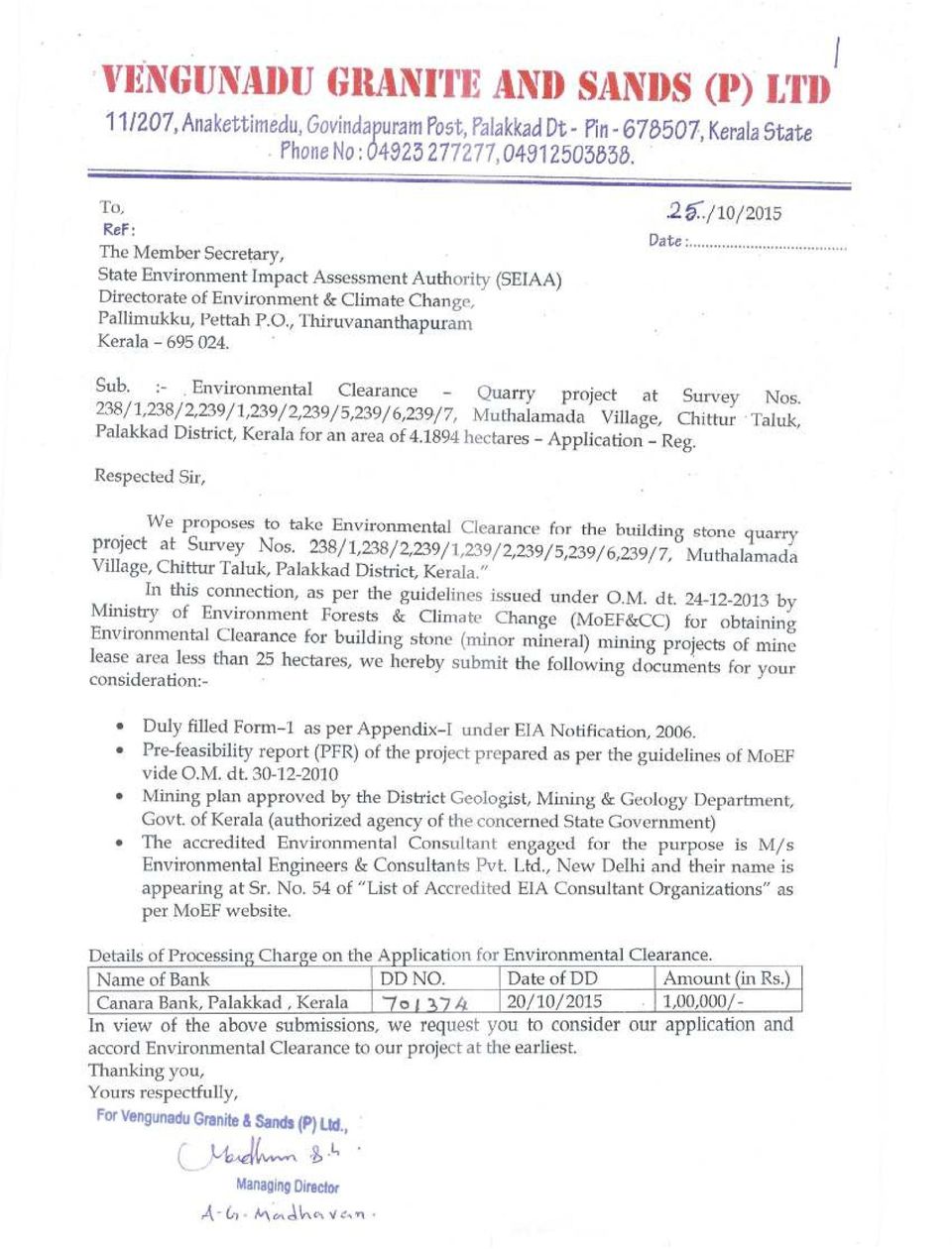
2 2 BASIC CHECKLIST REQUIRED FOR SUBMISSION OF APPLICATION SR. NO. PARTICULARS YES/ NO Page no Is the application contain covering letter by the project proponent addressed to Member Secretary, SEIAA? Is the covering letter contain the signature of the project proponent in ink color other than black? Is the covering letter contain the name of the project proponent in handwritten by himself? YES 1 YES 1 YES 1 4 Is there an index page with the application? YES 3 5 Is the applicable checklist attached with the application attached with the application? YES Is the checklist contain the page numbers? YES Is the application has continuous page number from the beginning till end? YES Did all columns of Form I duly filled? YES Did the Form I contain the signature of the project proponent along with his name in handwritten by himself in ink color other than black? Did the ID proof of the project proponent attached with the application? Is the Pre-feasibility report and Mining plan attached with the application? Did the attested copy of the accreditation certificate of the consultancy organization attached with the application? Did the ID proof of the EIA coordinator attached with the application? Did the attested recent photograph of the project proponent attached with the application? YES 22 YES YES YES YES 230 YES 195

3 3 INDEX S. No. Particulars Page No. 1 Covering letter 1 2 Basic check list 2 3 Index 3 4 Checklist for mining projects Form Questionnaire for mining projects Pre-feasibility Report Mining plan approved by the District Geologist, Mining & Geology Department (Original) Letter of Intent issued by District Geologist, Mining & Geology Department, Govt. of Kerala Cluster certificate (status on other quarries located within 500 m radius) issued by District Geologist, Mining & Geology Department, 190 Govt. of Kerala 11 Proof of ownership of land Tax Receipts Proof of Authorized Signatory Attested ID Proof of the Authorized Signatory Attested recent photograph of the authorized signatory Resolution by the partners of the Partnership firm (Original) Notarized copy of Certificate of Incorporation and the page in which the name of Directors appear Cadastral map duly signed by Village officer (Original) Recent photographs of the project site with digital dates of the camera Area Survey plan approved by Village Officer (Original) Analysis reports from accredited laboratories (Original) Ambient air quality reports W ell / open well / pond water test reports Ambient noise level reports Attested copy of accreditation certificate of Laboratory conducting Environmental analysis Attested true copy of NABET accreditation certificate of the consultancy organization Attested true copy of NABET accreditation certificate of the consultancy organization Photo I.D of EIA Coordinator Undertaking responsibility for the proposal submitted Affidavit by the project proponent Soft copy of the proposal (in PDF format) 234
 issued by District Geologist, Mining & Geology Department, 190 Govt.")
4 CHECKLIST FOR MINING PROJECTS seeking Environmental Clearance Sr. Item Page No. Description No. 1. Category/Sub category & Schedule Category B/B2 & 6 Schedule 1 (a) 2. Form I Attached 6-22 Questionnaire for mining projects Attached Pre-feasibility report Attached Environment Management Plan Included in PFR Whether the project site falls within ESZ-1 of WGEEP report or ESA of HLWG Report status = Not in ESA -- HLWG 4. Proof of ownership of land Attached Proof of authorized signatory Attached Cadastral map duly signed by Village Officer (original) Attached Recent photographs of the project site with digital dates of the camera Attached Area survey plan approved by Village officer (original) Attached Panoramic view of the site / Google Attached 96 image with date GPS readings in WGS 84 datum Latitude (N) Longitude (E) 10 34'45.58"N to 10 34'53.13"N 76 48'39.54"E to "E 10. Distance of the mining area from the nearest human settlement 140 m Right & nature of land (as per records) Private land Is the property forest land/govt. land/own land Private own land Extent of land in hectares ha Proposed production capacity 1,50,000 MTA Expected life of mine (in years) About 14 years Ultimate depth of mining (in MSL) 70 m MSL Quantity of topsoil estimated to be removed 23,087 cu. m Method of mining Open cast Underground mining if any proposed No Analysis reports from accredited laboratories (original) Attached Attested copy of accreditation certificate of laboratory conducting Attached Environmental Analysis 22. Waste management proposals Provided in PFR - EMP Mined area management Provided in PFR Attested true copy of NABET accreditation certificate (Original to be produced for verification at the time of presentation with photo ID of the EIA Co-ordinator) Attached
 Attached 202 7.")
5 a) Accreditation with serial number of QCI / NABET b) Undertaking responsibility for the proposal submitted c) Joint undertaking with the project proponent for implementation of EMP and EC conditions 1. Constitution of Environment Monitoring Cell 2. Providing fire fighting system 3. Providing systems to minimize dust emissions 4. To provide adequate safety measures for the construction workers during the construction phase 5. To upload the following in the website of the project: a) EC order b) Status of compliance of the stipulated EC conditions c) Results of monitoring data and update the same periodically AND d) Send the copy of the EC to the LSG concerned 25. Affidavits for: (indicating the name of project and location) 26. Proposals for Corporate Social responsibility (Amount, activities and duration with specific details) 27. Total cost of the project with details of insurance, funding etc 28. Soft copy of the proposal (in PDF format) 29. Details of Authorized Signatory (Name, Postal address, Pin code, Telephone No., Fax No., ID) 30. Details of NABET approved EIA consultant organization 5 Sr. No Attached 231 Not provided -- Attached Provided Project Cost = Rs Crores Insurance = Insurance to the quarry w orkers w ould provide through insurance company. Funding = Ow n source & bank loan 33 P Provided 234 Mr. A.G. Madhavan, Managing Director, M/s Vengunadu Granite and Sands Pvt. Ltd. Anakkattimedu, Moochankundu, Govindapuram P.O., Muthalamada, Palakkad District, Kerala. Ph , Mobile No E- mail :- prasadsyr@gmail.com & rupeshraj.67@gmail.com M/s Environmental Engineers & Consultants Pvt. Ltd., A1-198, Janak Puri, New Delhi
 EC order b) Status of compliance of the stipulated EC conditions c) Results of monitoring data and update the same periodically AND d) Send")
6 FORM - 1 6

7 7 I Basic Information APPENDIX I (See paragraph 6) FORM - 1 S. No. Item : Details 1. Name of the Project : Masonry Stone Mine ( Quarry ) project of 2. S. No. in the schedule : 1(a) 3. Proposed capacity/ area/ length/ tonnage to be handled /command area/ lease area /number of wells to be drilled M/s Vengunadu Granite and Sands Pvt. Ltd. : Proposed Capacity 1,50,000 MTA Area Mineable reserves Life of Mine 4. New/ Expansion / Modernization : Existing Quarry Project hectares 19,86,500 MT About 14 years 5. Existing capacity/ Area etc. : Existing Quarry: The quarry was working with short term 6. Category of project i.e. 'A' or 'B' : B 7. Does it attract the general condition? If yes, please specify. 8. Does it attract the specific condition? If yes, please specify. : No : No permits issued by Mining & Geology Department, Govt. of Kerala. 9. Location : The proposed building stone quarry project is situated at Survey Nos. 238/1, 238/2, 239/1, 239/2, 239/5, 239/6, 239/7, Muthalamada 1 Village, Muthalamada Panchayath, Chittur Taluk, Palakkad District, Kerala in an area of hectares. The geographical location of the mine with respect to the pillar boundary is given below:- Latitude (N) Longitude (E) 10 34'45.58"N to 10 34'53.13"N 76 48'39.54"E to "E Plot/ Survey/ Khasra no. : Survey Nos. 238/1, 238/2, 239/1, 239/2, 239/5, 239/6, 239/7 Land status : Private own land ( hectares ) Village : Muthalamada 1 Tehsil : Chittur District : Palakkad District State : Kerala

8 10. Nearest Railway station/ Airport along with distance in kms. 11. Nearest Town, City, District Headquarters along with distance in kms. 12. Village Panchayat, Zilla Parishad, Municipal Corporation, Local body (Complete postal address with telephone no. to be given). : Particulars Name Distance (From lease) Railway Muthalamada 7 km, NW Station Station Airport Coimbatore Airport 65 km, NE : Particulars Name Distance, Direction 8 (From lease) Nearest Town Kollengode 17 km, NW : Village Office :- Muthalamada Village Office, Muthalamada, Chittur, Palakkad District, Kerala Panchayat Office :- Panchayat Secretary, Muthalamada Grama Panchayat, Chittur, Palakkad District, Kerala Tel. No Name of the applicant : M/s Vengunadu Granite and Sands Pvt. Ltd. 14. Registered address : N.A. 15. Address for correspondence Name : Mr. A.G. Madhavan, Designation (Owner / Partner / CEO) : Managing Director Address : Mr. A.G. Madhavan, Managing Director, M/s Vengunadu Granite and Sands Pvt. Ltd. Anakkattimedu, Moochankundu, Govindapuram P.O., Muthalamada, Palakkad District, Kerala Ph , Mobile No Pin Code : prasadsyr@gmail.com & rupeshraj.67@gmail.com Telephone no. : Ph , Mobile No Fax No. : N.A. 16. Details of alternative sites examined, if any. Location of these sites should be shown on a Toposheet. 17. Interlinked projects : None 18. Whether separate application of interlinked project has been submitted? : The current proposal is for the existing quarry project and mineral specific hence no alternate site was examined. : Not Applicable 19. If yes, date of submission : Not Applicable

9 20. If no, reason : Not Applicable 21. Whether the proposal involves approval / Clearance under: if yes, details of the same and their status to be given. (a) The Forest (Conservation) Act, (1980)? : Not Applicable (b) The Wildlife (Protection) Act, 1972? Not Applicable (c) The C.R.Z. Notification, 1991? Not Applicable 22. Whether there is any : The following Govt. Orders / Policies are to be followed:- Government Order / Policy Kerala Minor Mineral Concession Rules, relevant / relating to the site: Mines Act, 1952 Explosive Rules, 2008 Kerala Panchayat Raj Act, 1994 Central Ground Water Authority Water Pollution (Prevention & Control) Act, 1974 Air Pollution (Prevention & Control) Act, 1981 Environment Protection Act, 1986 EIA Notification, 2006 / 2009 The Kerala Promotion of Tree Growth in Non-Forest Areas (Amendment) Act, Forest land involved (hectare) : No Whether there is any litigation pending against the project : No litigation is pending against the lease area/ applicant of the proposed lease area in any court of law. and/or land in which the project is proposed to be set up? (a) Name of the Court (b) Case No. (c) Orders / directions of the court, if any and its relevance with the proposed project. 25. Expected cost of the project : Rs Crores *Capacity corresponding to sectoral activity (such as production capacity for manufacturing, mining lease area and production capacity for mineral production, area for mineral exploration, length for linear transport infrastructure, generation capacity for power generation etc.,)
 Act, 1974 Air Pollution")
10 II Activity 1. Construction, operation or decommissioning of the Project involving actions, which will cause physical changes in the locality (topography, land use, changes in water bodies, etc.) S. No. Information/Checklist confirmation Yes/ No Details thereof (with approximate quantities /rates, wherever possible) with source of information data 1.1 Permanent or temporary change on land use, land cover or topography including increase in intensity of land use (with respect to local land use plan) Yes Land use: - The project site is private owned land. There is expected to be change in the land use as mining area in the core zone. The highest elevation of the lease area is 105 m. MSL and lowest is 80 m MSL. As the proposed area is hilly, the drainage is towards SE to NW. However, any other significant impact will be confined within the lease area. 1.2 Clearance of existing land, Yes The area for proposed quarry is rocky land with vegetation and buildings? some native trees, climbers, grass, shrubs, herbs etc. There is no existing building in the proposed area. 1.3 Creation of new land uses? Yes The present land use as per the revenue record is private owned land. The new land use pattern will be as follows as per post operational use :- 1. Excavated Pit : ha. (reclaimed by plantation and pond). 2. Drainage : Green belt: Pre-construction investigations No Not applicable e.g. bore holes, soil testing? 1.5 Construction works? Yes Facilities like site office, labour quarters and magazine area will be developed within the complex and will be utilized. 1.6 Demolition works? No Not applicable 1.7 Temporary sites used for No Not applicable construction works or housing of construction workers? 1.8 Above ground buildings, Yes The proposed project activity involves 87% of the structures or earthworks including linear structures, cut and fill or excavations. pit area for exploiting the building stone up to the conceptual phase. As the area is devoid of any structures above ground so there will not be any 10

11 impact due to mining activity. The production will have ha. area as pit at the conceptual stage. The extent of impact will however be confined to lease area only. 1.9 Underground works including No There will be no underground mining activities. mining or tunneling? The mining will be done by open cast semimechanized method of mining Reclamation works? Yes At the end of life of mine, the total excavated area will be ha. and the same will be reclaimed by plantation Dredging? No Not Applicable 1.12 Offshore structures? No Not Applicable 1.13 Production and manufacturing processes? Yes The mining will be done by semi - mechanized opencast method as per approved Mining Plan. It includes blasting, loading, transport and excavation activities. The working will be done by forming benches of 5.0m (average) height. Mining will be started from the first year with systematic working. The height of the bench will not be kept more than 5.0m. The mining will be done with the help of tools such as drills, jack hammer, compressors, picks, excavators etc. The impact on physical environment will be significant and confined to lease area. There will be change in land cover, topography & vegetal cover as depicted in point no Facilities for storage of goods or materials? Yes Facilities will be developed for :- 1. Mineral will be transported to designated place. 2. Top soil and waste generated during the plan period will be dumped outside the mining area at pre determined place and will be utilized over reclaimed areas for plantation. 3. Overburden will be utilized within the pit for lying of haul road and at the end, it will be use 11

12 for soil base for plantation Facilities for treatment or disposal of solid waste or liquid effluents? Yes Solid Waste A total quantity of 23,087 cu. m. of topsoil and 8,465 cu. m of over burden will be removed during the mining operations. The topsoil excavated from the quarry will be dumped separately at pre-determined place and subsequently will be utilized in spreading over reclaimed areas for plantation. OB will be utilized for laying internal haul road and will form base in reclamation / plantation. Liquid Effluent The sewage to a tune of 0.8 KLD generated from the mine office will be diverted to the septic tank followed by soak pit Facilities for long term housing of operational workers? Yes Labour quarters will be provided within the complex but outside the proposed lease area New road, rail or sea traffic during construction or operation? Yes For the purposes of mining activities, existing roads are sufficient. However, haul road will be suitably developed within the proposed area New road, rail, air waterborne or Yes For the purposes of mining activities, existing other transport infrastructure roads are sufficient. However, haul road will be including new or altered routes suitably developed within the proposed area. and stations, ports, airports etc? 1.19 Closure or diversion of existing No Not Applicable transport routes or infrastructure leading to changes in traffic movements? 1.20 New or diverted transmission No Not Applicable lines or pipelines? 1.21 Impoundment, damming, Yes The run-off from the lease area will be suitably culverting, realignment or other changes to the hydrology of water courses or aquifers? collected through channels and will be stored in storm water pond for further utilization in Mine. However, all measures will be taken not to disturb the natural drainage system of the surrounding area 1.22 Stream crossings? No Not applicable 1.23 Abstraction or transfers of water from ground or surface waters? Yes The water to a tune of 1 KLD will be drawn from the wells for domestic purpose. 12

13 1.24 Change in water bodies or the land surface affecting drainage or run -off? No There will be no change in water bodies. The change in the land surface due to mining will not affect the surface drainage or run off Transport of personnel or Yes Vehicles will be engaged for mineral and material materials for construction, transport. About 33 trips of 15 T capacity will be operation or decommissioning? utilized for transporting the mineral on daily basis Long-term dismantling or Yes At the end of life of mine, excavated pit will be decommissioning or restoration works? backfilled and reclaimed and rehabilitated by plantation with native species so as to restore the natural eco-system Ongoing activity during Yes At the end of life of mine, reclamation of the area decommissioning which could will be carried out. Suitable plantation with have an impact on the shrubs, herbs & trees will be done as a part of environment? eco-restoration work Influx of people to an area in Yes Due to the mining activity and due to the attached either temporarily or ancillary unit, there will be workers attracted to permanently? the project area. It is proposed to employ 20 persons in the project Introduction of alien species? No Not applicable 1.30 Loss of native species or genetic diversity? Yes Due to the mining activities, there will be loss of some native species and vegetation. However, some of these species will be planted at the end use for eco-restoration Any other actions? No Nil 2. Use of Natural resources for construction or operation of the Project (such as land, water, materials or energy, especially any resources which are non-renewable or in short supply):- Information/ checklist Yes/ Details thereof (with approximate quantities confirmation No /rates, wherever possible) with source of information data 2.1 Land especially undeveloped or agricultural land (ha) Yes The lease area consists of ha, which is private land and present land use is rocky land with quarrying activities. 2.2 Water (expected source & Yes The daily water demand will be only 5 KLD. competing users) unit: KLD Well water to meet the drinking water and other domestic water requirement about 1 KLD of the workers and the staff. A storm water collection pond for meeting the water requirements of ancillary units and other 13

14 dust separation systems. 2.3 Minerals (MT) Yes It is a mining project for excavation of building stone. Production will be 1,50,000 MTA. This is available in abundance in Kerala and some other states and is being used in construction of roads and buildings. 2.4 Construction material stone, aggregates, sand / soil (expected source MT) Yes The infrastructure facilities like mine office, labour shed, canteen, etc. will be developed and small quantity of construction material is required. 2.5 Forests and timber (source MT) No Not applicable 2.6 Energy including electricity and fuels (source, competing users) Unit: fuel (MT), energy (MW) Yes Electricity:- The total power requirement will be 75 kw, which will be drawn from diesel engine. Fuel Quantity 16 to 20 lt/ hr. 2.7 Any other natural resources (use Yes Use of solar energy for external lightings. appropriate standard units) 3. Use, storage, transport, handling or production of substances or materials, which could be harmful to human health or the environment or raise concerns about actual or perceived risks to human health. S. No. Information/Checklist confirmation Yes/ No Details thereof (with approximate quantities / rates, wherever possible) with source of information data 3.1 Use of substances or materials, which are hazardous (as per MSIHC rules) to human health or Yes Nitrate Fuel Oil (NFO) mixture which is an explosive substance and is hazardous. Also the detonators used for blasting is a hazardous the environment (flora, fauna, chemical. However, a limited quantity in and water supplies) compliance with Explosives Act will be stored in the magazine for safety of the workers. 3.2 Changes in occurrence of No Not applicable disease or affect disease vectors (e.g. insect or water borne diseases) 3.3 Affect the welfare of people e.g. by changing living conditions? Yes The present project will directly/ indirectly develop the area by providing employment opportunities. With the proposed development in and around the area there will be many supporting facilities/ infrastructure eventually leading to the development of the area. 3.4 Vulnerable groups of people who Yes The nearest house is located at 140 m, SE side 14
 No Not applicable 2.")
15 could be affected by the project e.g. hospital patients, children, the elderly etc., of the proposed quarry. All necessary measures will be taken to operate the mine in compliance with air, water, noise and vibration standards from time to time. 3.5 Any other causes No Not applicable 4. Production of solid wastes during construction or operation or decommissioning (MT/month) S. No. Information/Checklist confirmation Yes/ No Details thereof (with approximate quantities / rates, wherever possible) with source of information data 4.1 Spoil, overburden or mine wastes Yes About 23,087 cu.m of top soil and 8,465 cu.m. of overburden will be generated from the proposed mine. 4.2 Municipal waste (domestic and or Yes The municipal solid waste generated from the commercial wastes) labour quarter will be suitably disposed along with reclamation or back filling. 4.3 Hazardous wastes (as per Yes Negligible in quantity like used oil which will be Hazardous Waste Management disposed to the local recyclers. Rules) 4.4 Other industrial process wastes. No Not applicable 4.5 Surplus product. No Not applicable 4.6 Sewage sludge or other sludge from effluent treatment. Yes The sludge generated from the septic tank on a periodical basis will be dried and will be used as manure in plantation. 4.7 Construction or demolition No Not applicable wastes. 4.8 Redundant machinery or No Not applicable equipment. 4.9 Contaminated soils or other No Not applicable materials Agricultural wastes. No Not applicable 4.11 Other solid wastes. No Not applicable 5. Release of pollutants or any hazardous, toxic or noxious substances to air (Kg/hr) S. Information/ Checklist Yes/ Details thereof (with approximate quantities / No. confirmation No rates, wherever possible) with source of information data 5.1 Emissions from combustion of fossil fuels from stationary or Yes Diesel engine emissions rates (Unit - g/kwhr) are given below: 15
 with source of information data 4.")
16 mobile sources. PM - 0.3; NOx - 9.2; CO - 3.5; HC Transportation: Movement of vehicles will generate dust. The transportation activities on unpaved area results in fugitive emissions to the tune (Unit - kg/veh.mt) of for PM 10 and for PM 2.5 (USEPA-AP42 series). Gaseous Emission rate (Unit - g/kwh) due to transportation: CO ; HC ; NOx All measures will be taken to restrict the emission within CPCB norms. 5.2 Emissions from production Yes The proposed production will be 1,50,000 MTA. processes. Dust is the main pollutant, which will be generated mainly from mining activities (drilling, blasting and excavation) and vehicle movement. The different measures taken to control dust emissions are given below:- Water sprinkling on haul roads Wet drilling Limiting the speed of the vehicles Regular maintenance of vehicles / equipments Loaded Trucks will be covered with tarpaulin sheets during transportation Greenbelt development 5.3 Emissions from materials Yes There will be fugitive emissions generated during handling including storage or transport. material handling, transportation, loading and unloading etc. Regular water sprinkling on haul road will suppress the dust particles and prevent them from getting air-borne. Transportation Movement of vehicles like dumpers, trucks, tankers etc. will also generate dust. The transportation activities on unpaved area results in fugitive emissions to the tune of kg / VkmT for PM 10 and kg/vkmt for PM Emissions from construction No Not applicable activities including plant and equipment 16
 and vehicle movement.")
17 5.5 Dust or odors from handling of materials including construction materials, sewage and waste. Yes There is no odor from handling of material. Only dust will be generated from transportation & handling materials. The dust emission will be controlled by adopting suitable measures viz. water sprinkling, plantation, making enclosures & maintaining roads. Personnel Protective Equipment (PPE s) will be provided to the workers. Periodical medical examination will be arranged to the employees at intervals of not more than 5 years. 5.6 Emissions from incineration of No Not applicable waste 5.7 Emissions from burning of waste No Not applicable in open air (e.g. slash materials, construction debris) 5.8 Emissions from any other No Not applicable sources 6. Generation of Noise and Vibration, and Emissions of Light and Heat S. No. Information/ Checklist confirmation Yes/ No Details thereof (with approximate quantities/ rates, wherever possible) with source of information data 6.1 From operation of equipment e.g. Yes Mining operation is being carried out by semimechanized engines, ventilation plant, method. However based on crushers production capacity mining equipments configuration with expected noise levels (in db(a)) will be as under:- Excavator Compressor - 81 Tippers/ Trucks Mobile Crane - 83 Mitigation Measures:- Maintenance of machinery Enclosed cabins in excavator Earmuff & earplug Periodical medical checkup Noise level maintained to 85dB(A) 6.2 From industrial or similar No Not applicable processes 6.3 From construction or demolition No Not applicable 17

18 6.4 From blasting or piling Yes Controlled Blasting (Milli second electric) technique will be adopted to restrict the PPV levels well below the DGMS standards of <15 mm/ sec at all times. The blasting will be done at designated hours i.e. 04:00 pm. 6.5 From construction or operational Yes Due to vehicular traffic and material traffic transportation within the lease area, noise will be generated. However, the expected noise levels will be well maintained within the DGMS and CPCB norms. 6.6 From lighting or cooling systems No Not applicable 6.7 From any other sources No Not applicable 7. Risks of contamination of land or water from releases of pollutants into the ground or into sewers, surface waters, groundwater, coastal waters or the sea:- S. Information/ Checklist Yes/ Details thereof (with approximate quantities / No. confirmation No rates, wherever possible) with source of information data 7.1 From handling, storage, use or spillage of hazardous materials No NFO Mixture is proposed to be used for blasting purpose. Due care will be taken to avoid risk during handling, storage, use or spillage of explosives. However, a 300 kg magazine is there for storing the explosive. 7.2 From discharge of sewage or other effluents to water or the No There is no risk of contamination of land and water due to discharge of untreated wastewater. land (expected mode and place However, no untreated sewage will be of discharge) discharged in the open land causing the contamination to ground water. The wastewater generated will be channelized in the septic tank followed by soak pit By deposition of pollutants emitted to air into the land or into water No During operation phase there will be mainly dust emissions from excavation, loading, unloading, mineral handling, transportation and mobile sources. Measures like controlled blasting, water sprinkling, green belt development etc. will be adopted to minimize the same. 7.4 From any other sources No There will not be any other sources, which will contaminate land and water resources.

19 7.5 Is there a risk of long term build No Nothing will be significant. up of pollutants in the environment from these sources? 8. Risk of accidents during construction or operation of the project, which could affect human health or the environment. S. No. Information/Checklist confirmation Yes/ No Details thereof (with approximate quantities / rates, wherever possible) with source of information data 8.1 From explosions, spillages, fires etc. from storage, handling, use Yes The stone quarry mine will result in increase in frequency of blasting for mining the mineral. or production of hazardous However, controlled blasting with optimum charge of substances holes will be carried out to loosen the rock. Explosion hazards are envisaged due to mishandling of explosives. Explosives will be handled with utmost care in compliance of conditions imposed by Chief Controller of Explosive & Metalliferous Mines Regulation, NFO mixture, slurry explosive, safety fuse, and detonators will be used for blasting. 8.2 From any other causes Yes The risks of accidents are envisaged due to the operation of equipments, failure of mine pit etc. Pit slope will be kept at 45. Face slope will be kept at 70. No loose stone will be allowed near the edges of excavation and along the sites of haul road. However, good safety practices will be adopted at the site. All precautionary measures will be adopted and use of protective equipments will be mandatory. However, for minor incidences and accidents first aid measures will be provided at site. 8.3 Could the project be affected by Yes Zone-III, Moderate damage risk zone as per natural disasters causing BMTPC, vulnerability atlas seismic zone of India environmental damage (e.g IS: Floods, earthquakes, landslides, cloudburst etc)? There is no history of flood, earthquake, cloud burst and landslide reported so far. 9. Factors which should be considered (such as consequential development) which could lead to environmental effects or the potential for cumulative impacts with other existing or planned activities in the locality S. Information/ Checklist Yes/ Details thereof (with approximate quantities / 19

20 III No. confirmation No rates, wherever possible) with source of 9.1 Lead to development of supporting cities, ancillary development or development stimulated by the project which could have impact on the environment e.g.: Supporting infrastructure (roads, power supply, waste or waste water treatment, etc.) housing development extractive industries supply industries other 9.2 Land to after use of the site, which could have an impact on environment. 9.3 Set a precedent for later developments. 9.4 Have cumulative effects due to proximity to other existing or planned projects with similar effects. Environmental Sensitivity S. No. Areas Yes Yes Yes No 1 Areas protected under international conventions, national or local legislation for their ecological, or other related value landscape, cultural 2 Areas which are important or sensitive for ecological reasons - Wetlands, watercourses or other water bodies, coastal zone, biospheres, mountains, information data 20 The proposed project will directly / indirectly develop the area by providing employment opportunities. With the proposed development in and around the area there will be many supporting facilities/ infrastructure eventually leading to the development of the area. The land used will be fully reclaimed and rehabilitated by backfilling the pits and plantation. Plantation and afforestation will add to the improvement in environment and aesthetic beauty of the area. There will be other ancillary developments which spring up due to the coming of the project, resulting in setting a precedent for later development. There is no quarry in operation within 500m radius. Name/ Identity No Aerial distance (within 15 km) proposed project location boundary None within the study area Yes Forest: - Nelliyampathi Reserve Forest, 15 km, SW Aaliyar Reserve Forest, 14 km, S

21 forests Water Bodies :- Chuliyar Dam, 5 km, NW Meenkara Dam, 6 km, N 3 Areas used by protected, important or sensitive species of flora or fauna for breeding, nesting, foraging, resting, over wintering, migration 4 Inland, coastal, marine or underground waters No None within the study area Yes Water Bodies :- Chuliyar Dam, 5 km, NW Meenkara Dam, 6 km, N 5 State, National boundaries Yes Tamil Nadu State boundary 2 km, E 6 Routes or facilities used by the public for access to recreation or other tourist, pilgrim areas Yes Religious places :- Kilavanpudur Church, 4 km, NE Kilavanpudur Temple, 4 km, NE Muthalmada Mosque, 7 km, NW 7 Defense installations No None within the study area 8 Densely populated or built-up area Yes Town Kollengode, 17 km, NW 9 Areas occupied by sensitive man-made land uses (hospitals, schools, places of worship, community facilities) 10 Areas containing important, high quality or scarce resources (ground water resources, surface resources, forestry, agriculture, fisheries, tourism, minerals) 21 Nearest house 140m towards SE Yes Nearest Hospital :- No Chulliyarmedu, 7 km, N Nearest School :- Chulliyarmedu, 7 km, N None within the study area 11 Areas already subjected to pollution or environmental damage. (those where existing legal environmental standards are exceeded) 12 Areas susceptible to natural hazard which could cause the project to present environmental problems (earthquakes, subsidence, landslides, erosion, flooding or extreme or adverse climatic conditions) No Earth Quake Zone None within the study area Zone-III, Moderate damage risk zone as par BMTPC, Vulnerability atlas Seismic zone of India IS:
22
23 23 QUESTIONAIRE FOR MINING PROJECTS S. No. Particulars Details 1. About the proposal a. Name and Address of the Mr. A.G. Madhavan, Managing Director, Proponent M/s Vengunadu Granite and Sands Pvt. Ltd. Anakkattimedu, Moochankundu, Govindapuram P.O., Muthalamada, Palakkad District, Kerala. Ph , Mobile No E- mail :- & b. Location and Specifications The proposed building stone quarry project is situated at Survey Nos. 238/1, 238/2, 239/1, 239/2, 239/5, 239/6, 239/7, Muthalamada 1 Village, Muthalamada Panchayath, Chittur Taluk, Palakkad District, Kerala in an area of hectares. The geographical location of the mine lease area is given below:- Latitude (N) 10 34'45.58"N to 10 34'53.13"N Longitude (E) 76 48'39.54"E to "E c. Social Infrastructure around the Nearest School Chulliyarmedu, 7 km, N project site (School, Hospital, Nearest Hospital Chulliyarmedu, 7 km, N Residences, Police Station, Fire Nearest Residence About 140m towards SE Station, Ambulance etc.) Nearest Police Kollengode, 17 km, NW Station Nearest Fire Station Chittur, 30 km, N Nearest Ambulance Chittur, 30 km, N d. Distance from the site to the nearest As under:- i. Water Bodies Water Bodies :- Chuliyar Dam, 5 km, NW Meenkara Dam, 6 km, N ii. Religious places like church, temple mosque etc. Kilavanpudur Church, 4 km, NE Kilavanpudur Temple, 4 km, NE Muthalmada Mosque, 7 km, NW
24 iii. Sensitive ecosystems like Wildlife Wildlife Sanctuaries - Nil Sanctuaries, Reserve Forests, Forest : Biosphere Reserves, Human Nelliyampathi Reserve Forest, 15 km, SW Inhabitation Aaliyar Reserve Forest, 14 km, S Biosphere Reserves Nil Human Inhabitation 140m, SE iv. Any electrical installations/ micro HT & LT Line About 500m SE Wave station/ Defense Mobile tower Muthalmada, 7 km, NW establishments etc. Defense Establishment None within the area a. Storage/ Safety of explosives Within the complex b. Fire and safety precautions Within the complex c. First Aid Within the complex d. No. of laborers to be employed at a 20 persons time and their safety e. Access road and width to the plot 7 m., tarred road, S f. Whether public or private & Private owned land Ownership 2. About the Mining Area a. Total Reserve Mineable 27,54,597 MT Geological 19,86,500 MT b. Contour Map Ref. Annexure No. 7 (Page No. 101) c. Sectional map showing overburdens (Average) Ref. Annexure No. 4 (Page No. 98) 24 d. Geology of the area (Secondary data) e. Hydrology indicating water bodies and ground water conditions (secondary data) Ref. PFR (Pre-feasibility Report) Section (Page No ) Ref. PFR Section (Page No ) f. 500m radius map showing the infrastructure Ref. Annexure No. 6 (Page No. 100) g. Land use pattern As under:-
25 Sr. No. Land Use Category Pre- Operational (Ha.) Operational for next five years (Ha.) 1 Top Soil Dump Nil Over burden Nil 3 Excavation (Voids Only) (Outside the mining area within own property) 25 Post Operational for life of mine (Ha.) Nil ( ha. Reclaimed by plantation & ha. Convert into pond) 4 Road Nil 5 Built Up Area Nil Nil Nil 6 Drainage Nil Green belt Nil Undisturbed Area Nil Total h. Baseline data of the environmental quality parameters Ref. PFR Section (Page No ) i. Biodiversity of the area specifying endemic and endangered species. Ref. PFR Section (Page No ) 3. About the Mining Activities a. Drawings indicating different facilities including Reduced Level (RL) Ref. Annexure No. 8 (Page No. 102) b. Details of method of working with phasing of activities, height and width of benches The proposed mining operations will be carried out by open cast semi-mechanized method. The salient features of proposed mining method are:- The height and width of the bench will be maintained at 5.0 m. The mining will be done from top to bottom by slicing of 2.5 m thick. The exploitation of mineral is being done up to 70 m. MSL in conceptual phase. Considering the stability of rocks the final slope or say ultimate pit slope is proposed 45 from vertical. Haul road will be developed up to point of loading. Transportation of the mineral from pit-mouth to destination will be by tippers/trucks (15T capacity). c. Details of drilling, blasting explosives Ref. PFR Section to (Page No. 44)
26 d. Transportation of material with route Ref. PFR Section (Page No. 45) e. Details of over burden (OB) removal and stacking Ref. PFR Section 3.9 (Page No. 46) f. Plan for managing storm water Ref. PFR Section (Page No ) g. Plan for power supply and water supply h. Plan for labour and safety in the 26 Power: - The total power requirement will be 75 kw, which will be drawn from diesel engine. Water: - The water required will be sourced from the well water/ storm water pond. mining area Ref. PFR Section (Page No ) i. Plan for managing dust, noise, silt and other pollutants. Ref. PFR Section (Page No ) 4. About the post mine plans a. Plan for green belt and fencing Ref. PFR Section (Page No ) b. Periodic monitoring of environmental quality and management Ref. PFR Section (Page No ) c. Mine Closure Plan Demolition of structure, removal of deleterious material and restoration of land for sustainable practices 5. About the Social Obligations a. Mitigation measures to reduce hazardous conditions and hardship to local inhabitants b. Addressing concerns of local inhabitants like health, water, employment, resettlement/ rehabilitation c. Compensation for loss of land, crops and other adverse impacts on account of mining d. Specific measures for Corporate Social Responsibility with success indicators Ref. PFR Section (Page No ) Ref. PFR Section (Page No ) Ref. PFR Section (Page No ) No R & R issues; Ref. PFR Section (Page No ) Ref. PFR Section (Page No ) *****************
27 PROJECT : Masonry Stone Mine (Quarry project) PRE - FEASIBILTY REPORT APPLICANT : M/s VENGUNADU GRANITE AND SANDS PVT. LTD. 27 PRE FEASIBILITY REPORT ENVIRONMENTAL ENGINEERS & CONSULTANTS PVT. LTD. October, 2015 Managing Director Mr. A.G. Madhavan
28 PROJECT : Masonry Stone Mine (Quarry project) PRE - FEASIBILTY REPORT APPLICANT : M/s VENGUNADU GRANITE AND SANDS PVT. LTD. 28 INDEX S. No. Contents Page No. 1.0 Executive Summary Salient Features of the project Proposed Planning Introduction of the project / Background information Identification of project and project proponent Brief description of the Nature of the project Need for the project and its importance to the Country and or Region Demand Supply Gap Imports Vs. Indigenous Production Export Possibilities Domestic / Export Markets Employment generation (Direct & Indirect) due to the project Project Description Type of project including interlinked and interdependent projects Location (map showing General Location, Specific Location & Project 39 boundary & Project site layout) with coordinates 3.3 Details of Alternate sites considered and the basis of selecting the 39 proposed site, particularly the environmental considerations 3.4 Size of magnitude of operation Project description with process details (a schematic diagram / flow chart 40 showing the project layout, components of the project etc should be given) Mineral Reserves Year wise production details Production record Proposed method of mining Open cast mining Salient features of mining method Extent of mechanization Drilling Blasting 44 ENVIRONMENTAL ENGINEERS & CONSULTANTS PVT. LTD. October, 2015 Managing Director Mr. A.G. Madhavan
29 PROJECT : Masonry Stone Mine (Quarry project) PRE - FEASIBILTY REPORT APPLICANT : M/s VENGUNADU GRANITE AND SANDS PVT. LTD Explosive used Storage of explosive Conceptual Mining Plan Raw material required along with estimated quantity, likely source, 45 marketing area of final products, mode of transport Mineral transportation Resource optimization / recycling and reuse envisaged in the project Availability of water its source, energy / power requirement & source Water Power Quantity of wastes to be generated (liquid and solid) and scheme for their 46 management / disposal 4.0 Site analysis Connectivity Land form, land use and land ownership Land form Land Use Land ownership Topography (along with map) Geology of the Area Hydrogeology Baseline Environment Air Environment Water Environment Noise Environment Existing Biological Environment Floral aspects Faunal aspects Social Infrastructure & Need Based Assessment Study Introduction Approach adopted Stake Holders 66 ENVIRONMENTAL ENGINEERS & CONSULTANTS PVT. LTD. October, 2015 Managing Director Mr. A.G. Madhavan
30 PROJECT : Masonry Stone Mine (Quarry project) PRE - FEASIBILTY REPORT APPLICANT : M/s VENGUNADU GRANITE AND SANDS PVT. LTD Muthalamada Grama Panchayat Panchayat at a Glance Demography Identified Corporate Social Responsibility Summary of CSR Activities Environmental Management Plan Land Environment Water Environment Storm Water Management Air Environment Impacts Management Noise Environment Impact Management Ground Vibration Blasting Hazards Blasting Vibration & Control Measures Fly Rock Control Measures Air Blast Control Measures Mine Closure Plan Risk Assessment & Disaster Management Plan Falls of sides Storage & use of explosives Storage of oil and fuel Water Disaster Management Plan Infrastructure Occupational Health and Safety Occupation Health Safety plan Safety Organization 82 ENVIRONMENTAL ENGINEERS & CONSULTANTS PVT. LTD. October, 2015 Managing Director Mr. A.G. Madhavan
31 PROJECT : Masonry Stone Mine (Quarry project) PRE - FEASIBILTY REPORT APPLICANT : M/s VENGUNADU GRANITE AND SANDS PVT. LTD Safety Circle Safety Training Health & Safety Monitoring Plan Existing land use pattern (agriculture, non-agriculture, forest, water bodies 83 (including area under CRZ)), shortest distances from the periphery of the project to the periphery of the forests, national park, wild life sanctuary, eco sensitive areas, water bodies (distance from the HFL of river), CRZ Land Use Pattern Distance from the Periphery of the project to the periphery of the forest, 84 National Park, Wild Life Sanctuary, Eco Sensitive Areas, Water Bodies, Notified Industrial Area, CRZ Area 4.5 Existing Infrastructure Soil Classification Climatic Data Social Infrastructure Available Planning Brief Planning Concept (Type of industries, facilities, transportation etc.) Town 86 & Country Planning / Development Authority Classification 5.2 Population Projection Land Use Planning (Break-up along with green belt etc.) Proposed Green belt development / Eco-restoration Compensatory mass plantation programme Environment Monitoring programme Baseline Environmental Quality Assessment of Infrastructure Demand (Physical & Social) Amenities / Facilities Proposed Infrastructure Industrial Area (Processing Area) Residential Area (Non-processing area) Green belt Social Infrastructure Connectivity (Traffic & Transportation Road / Rail etc.) 91 ENVIRONMENTAL ENGINEERS & CONSULTANTS PVT. LTD. October, 2015 Managing Director Mr. A.G. Madhavan
32 PROJECT : Masonry Stone Mine (Quarry project) PRE - FEASIBILTY REPORT APPLICANT : M/s VENGUNADU GRANITE AND SANDS PVT. LTD Drinking Water Management (Source & Supply of water) Sewerage system Industrial Waste Management Solid Waste Management Power Requirement & Supply / Source Rehabilitation and Resettlement (R & R Plan) Policy to be adopted (Central / State) in respect of the project affected 92 persons including home oustees, land oustees and landless 8.0 Project schedule and cost estimates Likely date of start of production and likely date of completion (time 93 schedule for the project will be given) 8.2 Estimated project cost along with analysis in terms of economic viability of 93 the project 9.0 Analysis of proposal Financial and Social Benefits with special emphasis on the benefits to the 94 local people including tribal population 10.0 Conclusion 94 Annexure No. Particulars 1. Route map showing location of the lease area 2. Google map showing location of the lease area 3. The Key map of the project site 4. Production & Development plan of the mining project 5. Conceptual plan (post mine closure plan) of the proposed mine area 6. Environmental plan showing all features site & surrounding within 500 m. radius 7. Topographical contour map of the project site 8. Surface cum geological plan of the lease area 9. Copy of format of the Report of Medical Examination under Rule 29B ENVIRONMENTAL ENGINEERS & CONSULTANTS PVT. LTD. October, 2015 Managing Director Mr. A.G. Madhavan
33 PROJECT : Masonry Stone Mine (Quarry project) PRE - FEASIBILTY REPORT APPLICANT : M/s VENGUNADU GRANITE AND SANDS PVT. LTD EXECUTIVE SUMMARY The proposed Stone Quarry Mine (Minor Mineral) of M/s Vengunadu Granite and Sands Pvt. Ltd. is situated at Survey Nos. 238/1, 238/2, 239/1, 239/2, 239/5, 239/6, 239/7, Muthalamada 1 Village, Muthalamada Panchayath, Chittur Taluk, Palakkad District, Kerala in an area of hectares. Mining projects of minor minerals with area less than 50 ha. of mining lease are categorized as category 'B' as per Notification S.O.2731(E) dated As per O.M. dated 24/12/2013 by Ministry of Environment & Forests, Govt. of India, all projects with mining area less than 25 hectares is classified as Category B2. The Eco-friendly Mining Plan has been approved by Mining & Geology Department, Govt. of Kerala. This Mining plan is based on the requirements under the Kerala Minor Mineral Concession Rules, The land for the proposed quarry is private owned land and the land is possessed in the name of M/s Vengunadu Granite and Sands Pvt. Ltd. The targeted production of mine will be 1,50,000 MTA. The estimated project cost will be Rs Crores. The expected life of mine estimated will be of about 14 years. The working will be carried out by opencast semi-mechanized method as per the approved Mining Plan. 1.1 SALIENT FEATURES OF THE PROJECT Particulars Details Geographical Location Latitude (N) 10 34'45.58"N to 10 34'53.13"N Longitude (E) 76 48'39.54"E to "E Total Mine Lease area hectare Total area owned by the proponent hectare Current status of the quarry Existing Quarry Project Local name of the project area Anakkattimedu Production 1,50,000 MTA Geological Reserves 27,54,597 MT Mineable Reserves 19,86,500 MT Life of Mine About 14 years Estimated project cost Rs Crores Man Power 20 Person ENVIRONMENTAL ENGINEERS & CONSULTANTS PVT. LTD. October, 2015 Managing Director Mr. A.G. Madhavan
APPENDIX I (See Paragraph -6) FORM I
 FORM I") APPENDIX I (See Paragraph -6) FORM I (I) Basic Information: Sl.. Item Details 1 Name of the project/s Removal of sand from Sand bar SB-G2 2 S.. in the schedule G 3 Proposed capacity / area/length / tonnage
APPENDIX I (See Paragraph -6) FORM I (I) Basic Information: Sl.. Item Details 1 Name of the project/s Removal of sand from Sand bar SB-G2 2 S.. in the schedule G 3 Proposed capacity / area/length / tonnage
APPENDIX I. (See Paragraph-6) FORM 1
 FORM 1") APPENDIX I (See Paragraph-6) FORM 1 (I) Basic Information S.. Item Details 1. Name of the Project/s Dankari Granite Black Stone Quarry 2. Sl. in the schedule Sairat case no- 91/ 12-13 3. Proposed capacity
APPENDIX I (See Paragraph-6) FORM 1 (I) Basic Information S.. Item Details 1. Name of the Project/s Dankari Granite Black Stone Quarry 2. Sl. in the schedule Sairat case no- 91/ 12-13 3. Proposed capacity
RISK ASSESSMENT REPORT
 RISK ASSESSMENT REPORT Submitted by: M/s D.D. Bricks Co. Prop. : Harbhagwan Village: Mohan Ke Uttar Tehsil: Guru Harsahai District: Ferozepur, Punjab (M): 0-99993-38601 Construction, operation or decommissioning
RISK ASSESSMENT REPORT
 RISK ASSESSMENT REPORT Submitted by: Rakesh Kumar, Partner M/s Maluka Bricks Industry Village Maluka, Sub-Tehsil Bhagta Bhaika, Tehsil & District Bathinda. (Punjab) (M): 0-98141-22141 1 ACTIVITY 2 1. Construction,
PRE-FEASIBILITY REPORT
 PRE-FEASIBILITY REPORT OF MASONRY MINING PROJECT (M.L. No. 107/02, ML Area: 1.0 ha) At Near Village-Banar Tehsil- Kotputli District - Jaipur (Raj.) PROJECT PROPONENT R/o Navratan Apartment, Plot No. 7A,
Form-1, Prefeasibility Report, Mining Plan for Rough Stone for S.F.Nos.: 332/1, 321/1 &
 Form-1, Prefeasibility Report, Mining Plan for Rough Stone for S.F.s.: 332/1, 321/1 & 321/3, THIRUPAIR Village, ULUNDURPET Taluk, VILUPPURAM District Tamil Nadu of THIRU.R. VIJAYAKUMAR. (Extent 0.83.50
Appendix I. Form 1 BASIC INFORMATION GRANITE MINING PROJECT VILLAGE KHARDA KI DHANI, TEHSIL ROHAT, DISTRICT PALI, RAJASTHAN
 Appendix I Form 1 BASIC INFORMATION GRANITE MINING PROJECT VILLAGE KHARDA KI DHANI, TEHSIL ROHAT, DISTRICT PALI, RAJASTHAN AREA: 1.0 HECT (NON FOREST LAND) ML: 56/2000 PRODUCTION CAPACITY: 46,653 TPA PROJECT
Form-1, Prefeasibility Report, Mining Plan for Rough Stone for S.F.No: 421/4(Part), LEMBALAKUDI Village, THIRUMAYAM Taluk, PUDUKKOTTAI
, LEMBALAKUDI Village, THIRUMAYAM Taluk, PUDUKKOTTAI") Form-1, Prefeasibility Report, Mining Plan for Rough Stone for S.F.: 421/4(Part), LEMBALAKUDI Village, THIRUMAYAM Taluk, PUDUKKOTTAI District Tamil Nadu of Thiru. S. APPAZ. (Extent 1.21.5Ha) FORM -1 (I)
Form-1, Prefeasibility Report, Mining Plan for Rough Stone for S.F.: 421/4(Part), LEMBALAKUDI Village, THIRUMAYAM Taluk, PUDUKKOTTAI District Tamil Nadu of Thiru. S. APPAZ. (Extent 1.21.5Ha) FORM -1 (I)
FORM - 1. Location/ Site alternatives under consideration : Block No. O : Contact Information : 98795 50353
 FORM - 1 I. Basic Information Name of project : Ajaysinh Bhupatsinh Suratia (Black Trap) Location/ Site alternatives under consideration : Block. O : Size of Project Lagu Survey. 17, Mahi River at Aklacha,
APPENDIX I (See Paragraph-6) FORM 1. S. No. Item Details
 FORM 1. S. No. Item Details") 1 APPENDIX I (See Paragraph-6) (I) Basic Information FORM 1 S.. Item Details 1. Name of the Project/s Rojnaguda Stone Quarry In Kalahandi district of Odisha 2. S. in the schedule 1 (a) 3. Proposed capacity
1 APPENDIX I (See Paragraph-6) (I) Basic Information FORM 1 S.. Item Details 1. Name of the Project/s Rojnaguda Stone Quarry In Kalahandi district of Odisha 2. S. in the schedule 1 (a) 3. Proposed capacity
Application Forms for Prior Environmental Clearance as per Environmental Impact Assessment Notification dtd 14-09-2006 & 01-12-09 & Ammendments
 Application Forms for Prior Environmental Clearance as per Environmental Impact Assessment tification dtd 14-09-2006 & 01-12-09 & Ammendments To be submitted By NITEEN PARMAR S/O SHRI NARENDRA SINGH PARMAR
PROPOSED TERMS OF REFERENCE
 PROPOSED TERMS OF REFERENCE ABOUT THE PROJECT: Rampura Marble Mine (ML No.- 420/91) is proposed by M/s Continental Minerals Pvt. Ltd. The Mine Lease area consists of 3.0 ha, which is located at Khasra
Project Details- Minor Minerals (Other Than Sand)
") Project - Minor Minerals (Other Than Sand) Sr. ABOUT THE PROPOSAL 1. Name of Lease Holder M/s. KARMANBHAI JODHABHAI RABARI (Partner) 2. Location address Mr. Karmanbhai Jodhabhai Rabari Survey No- 194 Paikee,
Project - Minor Minerals (Other Than Sand) Sr. ABOUT THE PROPOSAL 1. Name of Lease Holder M/s. KARMANBHAI JODHABHAI RABARI (Partner) 2. Location address Mr. Karmanbhai Jodhabhai Rabari Survey No- 194 Paikee,
Project Details-Minor Minerals (Other Than Sand)
") Project Details-Minor Minerals (Other Than Sand) Sr. No. Details Particulars ABOUT THE PROPOSAL 1. Name Of lease Holder M/s. Kirtikumar Samji Sengani 23 0'27.43"N 69 24'10.21"E 2. Location address Survey
Project Details-Minor Minerals (Other Than Sand) Sr. No. Details Particulars ABOUT THE PROPOSAL 1. Name Of lease Holder M/s. Kirtikumar Samji Sengani 23 0'27.43"N 69 24'10.21"E 2. Location address Survey
2. PRE-FEASIBILITY REPORT
 2. PRE-FEASIBILITY REPORT 2.1 Executive Summary The proposed project is Building stone quarry having lease area of 1.214 ha and falls under Category- A as per EIA Notification 2006 and its amendments of
2. PRE-FEASIBILITY REPORT
 2. PRE-FEASIBILITY REPORT 2.1 Executive Summary The proposed project is Building stone quarry having lease area of 0.809 ha and falls under Category- A as per EIA Notification 2006 and its amendments of
Project Details- Minor Minerals (Other Than Sand)
") Project - Minor Minerals (Other Than Sand) Sr. ABOUT THE PROPOSAL 1. Name of Lease Holder M/s. ABDUL MUNAF MOHAMMEDMIYA MALEK Mr.Abdul Munaf Mohammedmiya malek (Proprietor) 2. Location address OPP Block
Project - Minor Minerals (Other Than Sand) Sr. ABOUT THE PROPOSAL 1. Name of Lease Holder M/s. ABDUL MUNAF MOHAMMEDMIYA MALEK Mr.Abdul Munaf Mohammedmiya malek (Proprietor) 2. Location address OPP Block
Form-I for seeking clearance for project attracting CRZ notification
 Form-I for seeking clearance for project attracting CRZ notification Basic information: Name of the Project: - Proposed Beach Resort by A. R. RESORTS INDIA PVT. LTD. Location or site alternatives under
PRE- FEASIBILITY STUDY REPORT. M/s. SAI MINERALS
 PRE- FEASIBILITY STUDY REPORT FOR M/s. SAI MINERALS BLACK TRAP MINING (AREA 04-00-00 HECTARE) OF APPLICANT (Mr. AMARJITSINH R. VARACHHIYA) (PARTNER) AT SURVEY NO: 13, AT: ASHNAVI, TAL: JHAGADIA, DIST:
PRE FEASIBILITY REPORT
 PRE FEASIBILITY REPORT for PROPOSED PROJECT FOR SOIL MINING of M/s. BHAVINKUMAR VINODBHAI LAD SURVEY NO. 98, MOJE ANCHELI, TAL. BARDOLI, DIST. SURAT, GUJARAT 1 CONTENTS Sr. Description Page No. No. 1.
Proposed Terms of Reference for EIA studies
 1 Proposed Terms of Reference for EIA studies Base line data collection will be collected for the Post-Monsoon season 2016 (September to November 2016) in study area and 10 kms radius from project site.
TERMS OF REFERENCE FOR SCOPING OF EIA STUDY
 TERMS OF REFERENCE FOR SCOPING OF EIA STUDY Ours project is a proposed large scale unit and categorized as 5(h)-B as per the EIA notification 2006 of MoEFCC, New Delhi and subsequent amendments. Looking
PRE-FEASIBILITY REPORT
 PRE-FEASIBILITY REPORT OF MASONRY STONE (CHEJA PATTHAR) MINING PROJECT (ML Area: 1.0 ha, M.L. No. 65/2011, Production Capacity-1, 11,780 TPA) Near Village: Gangora, Tehsil: Pahari, District: Bharatapur
APPLICATION FOR ENVIRONMENTAL CLEARANCE
 APPLICATION FOR ENVIRONMENTAL CLEARANCE CREATIVE ENGINEERS & CONSULTANTS NABET ACCREDITED, NABL ACCREDITED TESTING LABORATORY& ISO 9001: 2008 CERTIFIED COMPANY 9B/4, BHARATHWAJAR STREET, EAST TAMBARAM,
1311/P, Khata No-570. Mariwada Malkangiri Malkangiri. APPENDIX I (See Paragraph-6) FORM 1. Basic Information. S. No. Item Details
 FORM 1. Basic Information. S. No. Item Details") 1 APPENDIX I (See Paragraph-6) (I) Basic Information FORM 1 S.. Item Details 1. Name of the Project/s Mariwada Stone Quarry In Malkangiri district of Odisha 2. S. in the schedule 1 (a) 3. Proposed capacity
1 APPENDIX I (See Paragraph-6) (I) Basic Information FORM 1 S.. Item Details 1. Name of the Project/s Mariwada Stone Quarry In Malkangiri district of Odisha 2. S. in the schedule 1 (a) 3. Proposed capacity
PRE- FEASIBILITY STUDY REPORT
 PRE- FEASIBILITY STUDY REPORT FOR RAJNIKANT GORDHANBHAI CHANIYARA PROPOSED BLACK TRAP MINING (AREA 03-00-53 HECTARE) OF APPLICANT (Mr.Rajnikant Gordhanbhai chaniyara) (PAWOR OF ATTORNEY) AT BLOCK NO: 66
ENVIRONMENT MANAGEMENT PLAN
 ENVIRONMENT MANAGEMENT PLAN OF M/s Baghel Infrastructure Pvt. Ltd. AT Khasra No 1203/1 Vill- Makrohar, Tehsil-Mada, District-Singrauli (M.P.) Production Capacity: 8158Cu.mt/year Metal Stone Area 1.00 Hectare
PRE - FEASIBILITY REPORT
 PRE - FEASIBILITY REPORT FOR OBTAINING PRIOR ENVIRONMENT CLEARANCE TO Building Stone MINING ACTIVITY FOR CATEGORY B3 UNDER THE EIA NOTIFICATION 3006 AMENDED ON 31/05/3013 TO 1.97.58 SHREE SHAH ENGINEERING
M/s Gokul Stone Industries
 Minor Mineral Black Trap Mine (Existing Project) Village : Rethvaniya, Ta : Chikhli, Dist : Navsari (Gujarat) Production Capacity : 2,50,000 TPA Area : 01-50-00 Ha. Proposal For Environmental Clearance
APPENDIX I FORM I. Basic Information
 APPENDIX I (I) Basic Information FORM I S.. Item Details 1 Name of the project/s Enhancement of Phosphoric Acid Production from 700 MTPD to 1000 MTPD P2O5 and other auxiliary Facilities within the Existing
ENVIRONMENT MANAGEMENT PLAN
 ENVIRONMENT MANAGEMENT PLAN FOR VILLAGE TEHSIL DISTRICT AREA MINERAL : Makrohar : Mada : Singrauli (M.P.) : 1.00 hect : Metal Stone KHASRA No : 176,178 PRODUCTION CAP : 15375 Cu.mt/year Metal Stone APPLICANT
How To Conduct An Environmental Impact Assessment
 Proposed Terms of Reference for EIA studies 1. Introduction The proposed expansion of Bulk Drugs & Intermediates manufacturing unit by M/s. Sri Krishna Pharmaceuticals Limited (Unit V). is located at Plot
2x800 MW Thermal Power Project Near Village Paraspani, Tehsil Pathargama, Godda- District By Adani Power (Jharkhand) Limited
 Limited") (IV) Proposed Terms of Reference for EIA Studies Project Category Project Proponent Location Paraspani Thermal Power Plant (2x800 MW) Coal based Thermal Power Project A [1(d) Thermal Power Plant 500 MW]
(IV) Proposed Terms of Reference for EIA Studies Project Category Project Proponent Location Paraspani Thermal Power Plant (2x800 MW) Coal based Thermal Power Project A [1(d) Thermal Power Plant 500 MW]
Pre- FEASIBILITY REPORT
 Pre- FEASIBILITY REPORT In Respect Of JHILIMINDA SAND BED OVER 20.30 ACRES OR 8.215 HA IN VILLAGE JHILIMINDA, ATTABIRA TAHASIL OF BARGARH DISTRICT, ODISHA (For the Financial Year-2015-16 to 2019-20) Prepared
ENVIRONMENT MANAGEMENT PLAN
 ENVIRONMENT MANAGEMENT PLAN OF Shri Kuldeep Choudhary AT Khasra No.Part of 112 Vill.-Golpura, Tehsil-Gandhwani, District-Dhar (M.P.) Production Capacity: 4543 Cu.mt/year Basalt Stone&4543 Cu.mt/year Murram
ENVIRONMENT MANAGEMENT PLAN
 ENVIRONMENT MANAGEMENT PLAN FOR VILLAGE TEHSIL DISTRICT AREA MINERAL : Kothi : Pawai : Panna (M.P.) : 1.370 Hectare : Flagstone KHASRA No : 31 PRODUCTION CAP : Max 875 Cu.mt/year Flagstone APPLICANT Shri
PRE FEASIBILITY REPORT
 PRE FEASIBILITY REPORT FOR M/S. AMRUT STONE QUARRY (AREA 2.57 HECTARE) OF APPILCANT MR. RAJNIKANT BHAGWANJIBHAI KATHIRIYA (Partner) AT BLOCK NO: 98,VILL: ZAB, TAL: MANDVI, DIST: SURAT 394163 GUJARAT. 1
ENVIRONMENTAL MANAGEMENT PLAN :-
 ENVIRONMENTAL MANAGEMENT PLAN :- The Environment Management Plan (EMP) is required to ensure sustainable development in the area of the proposed project. Hence it needs to be all encompassive plan for
ENVIRONMENT MANAGEMENT PLAN
 ENVIRONMENT MANAGEMENT PLAN ENVIrONMENT MaNaGEMENT plan 1. INTRODUCTION: Shri Ratilal Ravji Solanki have a Blacktrap mining lease project for an area of 1.00.00 Ha located on Survey no. 984 paiki, Village:
Form -1 Mining Plan & Pre-feasibility Report
 Form -1 Mining Plan & Pre-feasibility Report FOR QUARRYING OF GREY GRANITE (EXTENT 1.8.0Ha)-B2 PROJECT S.F.Nos 35/2D, 35/3, 35/2E (P)& 3/1A1 (P) Village Chendarapalli Taluk Krishnagiri District Krishnagiri
Form 1 as per EIA Notification 2006 for Meyyur Rough Stone Quarry of Thiru.N.Suresh Meyyur Village, Tiruvannamalai Taluk and District and Tamilnadu
 Form 1 as per EIA tification 2006 for Meyyur Rough Stone Quarry of Thiru.N.Suresh Meyyur Village, Tiruvannamalai Taluk and District and Tamilnadu Application Form for Obtaining Environmental Clearance
Application Form for Obtaining Environmental Clearance from State Level Environment Impact Assessment Authority (SEIAA) Tamilnadu
 Tamilnadu") Form 1 as per EIA tification 2006 for Vengadampatti Part-2 Rough Stone, Jelly and Gravel Quarry of Tmt. B.Lakshmi Rajam, Vengadampatti Part-2 Village, Alangulam Taluk, Tirunelveli District and Tamilnadu
Form 1 as per EIA tification 2006 for Vengadampatti Part-2 Rough Stone, Jelly and Gravel Quarry of Tmt. B.Lakshmi Rajam, Vengadampatti Part-2 Village, Alangulam Taluk, Tirunelveli District and Tamilnadu
PRE-FEASIBILITY CUM EMP REPORT FOR SAND EXTRACTION PROJECT (FROM RIVER PURNA PAT) FOR. KESHAVBHAI RATANJIBHAI PATEL 150 MT/day
 FOR. KESHAVBHAI RATANJIBHAI PATEL 150 MT/day") A PRE-FEASIBILITY CUM EMP REPORT FOR SAND EXTRACTION PROJECT (FROM RIVER PURNA PAT) FOR KESHAVBHAI RATANJIBHAI PATEL 150 MT/day VILL.:VIRPOR, TAL.: VALOD, DIST.: TAPI INDEX LIST OF CONTENTS CHAPTER DESCRIPTION
A PRE-FEASIBILITY CUM EMP REPORT FOR SAND EXTRACTION PROJECT (FROM RIVER PURNA PAT) FOR KESHAVBHAI RATANJIBHAI PATEL 150 MT/day VILL.:VIRPOR, TAL.: VALOD, DIST.: TAPI INDEX LIST OF CONTENTS CHAPTER DESCRIPTION
The Terms of reference (ToR) for conducting Rapid EIA study for the proposed project is described below:
 for conducting Rapid EIA study for the proposed project is described below:") Proposed Terms of Reference for EIA Study Objective: In order to identify the environmental impacts due to construction and operation of the proposed project and associated facilities, a study will be
Proposed Terms of Reference for EIA Study Objective: In order to identify the environmental impacts due to construction and operation of the proposed project and associated facilities, a study will be
Extent : 2.12.5Ha S.F. No. : 9/4A, 9/4B, 9/5, 10/3, 10/4 and 10/5 Village : Uthupatti Taluk : Kulithalai District : Karur State : Tamilnadu
 PROPOSAL TO OBTAIN ENVIRONMENTAL CLEARANCE FROM SEIAA. FOR Uthupatti ROUGH STONE QUARRY Extent 2.12.5Ha S.F.. 9/4A, 9/4B, 9/5, 10/3, 10/4 and 10/5 Village Uthupatti Taluk Kulithalai District Karur State
Pre- FEASIBILITY REPORT
 Pre- FEASIBILITY REPORT In Respect Of SRIPURA SAND BED-BOVER 35.25 ACRES OR 14.265 HA IN VILLAGE SRIPURA, JHARSUGUDA TAHASIL OF JHARSUGUDA DISTRICT, ODISHA (For the Financial Year-2015-16 to 2019-20) Prepared
Form -1 Mining Plan & Pre-feasibility Report
 Form -1 Mining Plan & Pre-feasibility Report TO OBTAIN ENVIRONMENTAL CLEARANCE FOR QUARRYING OF BLACK GRANITE (DOLERITE) (EXTENT 2.81.0Ha)-B2 PROJECT IN S.F.Nos 9,80,258/2B,258/6A & 258/6B Village Naduvanapalli
PRE FEASIBILITY REPORT
 PRE FEASIBILITY REPORT In Respect Of MAHUMUHAN STONE MINE 9 OVER 2.00 ACRES (0.81 HECTARE) IN VILLAGE MAHUMUHAN, SORO TAHASIL OF BALASORE DISTRICT, ODISHA (FOR THE PERIOD: 2015 16 TO 2019 20) APPLICANT
ENVIRONMENT MANAGEMENT PLAN
 ENVIRONMENT MANAGEMENT PLAN 1 [Type the company name] ENVIRONMENT MANAGEMENT PLAN LIMESTONE (BUILDING) 1.0. INTRODUCTION: The proposed M/s. Building Lime Stone Mine of Shree Jitubhai Parbatbhai Chudashma
Environment Management Plan
 Environment Management Plan FOR Mining of Sildhara Flage Stone Quarry Area-.1.50,Hectare Kh No-87 At Village- Sildhara, Tehsil Panna, Distt.Panna MR.BRIJMOHAN SINGH S/O SHRI JAI RAM SINGH RESI-VILLAGE
PRE FEASIBILITY REPORT
 PRE FEASIBILITY REPORT ON NAFRI STONE QUARRY NO.2 (IN MAYURBHANJ DISTRICT OF ODISHA) Lease Area: 4.97 acres or 2.01 Ha. of Sri Shyamsundar Bhattar & Others Baripada EXECUTIVE SUMMARY CHAPTER 1 Nafri Stone
M/s. Karshanbhai Bhagvanbhai Rabari
 PRE FEASIBILITY REPORT FOR M/s. Karshanbhai Bhagvanbhai Rabari Black TRAP MINING (AREA 1.00 HECTARE) OF APPLICANT Mr. Karshanbhai Bhagvanbhai Rabari (Proprietor) AT Survey No. 194 Paikee, Vill: Thoriyali,
FORM 1. Basic Information
 (I) Basic Information FORM 1 S. Item Details 1 Name of the Project /s Establishment of 1.5 M KCal/Hr (500 kg/hr) Hazardous Waste Incinerator (Upgradation) by M/s Ramky Enviro Engineers Limited. 2 S.. in
Proposed Terms of Reference for EIA studies
 Proposed Terms of Reference for EIA studies 1(a): STANDARD TERMS OF REFERENCE FOR CONDUCTING ENVIRONMENT IMPACT ASSESSMENT STUDY FOR NON-COAL MINING PROJECTS AND INFORMATION TO BE INCLUDED IN EIA/EMP REPORT
Village Panchayat Halkarni, Tal- Gadhinglaj, Dist- Kolhapur nos. to be given)
") (1) Basic Information APPENDIX 1 (See paragraph - 6) Serial Item Details Number 1. Name of the Project/s Stone Quarry of Mr. Yogesh Dundappa Chavan, Halkarni, Tal-Gadhinglaj, Dist- Kolhapur 2. Sr.. in
(1) Basic Information APPENDIX 1 (See paragraph - 6) Serial Item Details Number 1. Name of the Project/s Stone Quarry of Mr. Yogesh Dundappa Chavan, Halkarni, Tal-Gadhinglaj, Dist- Kolhapur 2. Sr.. in
PRE-FEASIBILITY CUM DETAIL PROJECT REPORT FOR SAND EXTRACTION PROJECT: 300 MT/DAY (FROM RIVER TAPI PAT)
") A PRE-FEASIBILITY CUM DETAIL PROJECT REPORT FOR SAND EXTRACTION PROJECT: 300 MT/DAY (FROM RIVER TAPI PAT) OF PADMABEN JAYANTIBHAI OAD RESI. AT: VILL: GHALA, TAL: KAMREJ, DIST: SURAT INDEX LIST OF CONTENTS
A PRE-FEASIBILITY CUM DETAIL PROJECT REPORT FOR SAND EXTRACTION PROJECT: 300 MT/DAY (FROM RIVER TAPI PAT) OF PADMABEN JAYANTIBHAI OAD RESI. AT: VILL: GHALA, TAL: KAMREJ, DIST: SURAT INDEX LIST OF CONTENTS
FORM -1 MINING PLAN & PRE-FEASIBILITY REPORT. FOR QUARRYING OF ROUGH STONE (Extent: 3.00.0Ha)-B2 Project
-B2 Project") FORM -1 MINING PLAN & PRE-FEASIBILITY REPORT FOR QUARRYING OF ROUGH STONE (Extent 3.00.0Ha)-B2 Project!!"# $%&'( )!*+ $*, % -!#( # )(!&.* /012 3345 36 7898 ;?DGGMN
FORM -1 MINING PLAN & PRE-FEASIBILITY REPORT FOR QUARRYING OF ROUGH STONE (Extent 3.00.0Ha)-B2 Project!!"# $%&'( )!*+ $*, % -!#( # )(!&.* /012 3345 36 7898 ;?DGGMN
TERMS OF REFERENCE. BEFORE CONSTRUCTION: Sl No TOR RESPONSE 1. Legalities of the land: Is the land The Project is clear from all angles.
 TERMS OF REFERENCE Name of the Project: M/s Suadela Constructions Pvt. Ltd. Address: Sy.No. 321/2B(P),321/2C(P),322/1,323/1(P),323/1(P),323/3,323/4,323/5(P), 323/6,323/7,325/1(P),325/2,327,328/1,328/2(P),328/3,328/4,330,331,332/2
ENVIRONMENT MANAGEMENT PLAN
 1.0 INTRODUCTION ENVIRONMENT MANAGEMENT PLAN The Environment Management Plan has been developed with a view to bring down the levels of impacts during proposed mining activities In each of the areas of
ENVIRONMENT MANAGEMENT PLAN
 ENVIRONMENT MANAGEMENT PLAN Page 33 ENVIRONMENT MANAGEMENT PLAN BLACK TRAP 1.0. INTRODUCTION: The proposed M/s. Black Trap Mine of Govindbhai Karshanbhai Ram area at near Vill.Chuldi, Tal.Malia-Hatina,
ENVIRONMENT MANAGEMENT PLAN
 6. REHABILITATION AND RESETTLEMENT (R & R) PLAN Since the project is private land, there is no reserves forest or protected forest land within the applied area. There is no human settlements within the
Pre-feasibility Report
 1.0 INTRODUCTION EXECUTIVE SUMMARY Balanga Sand Bed over an area of 12.50Ac./5.06Ha. of, Sri Nilamani Behera is located in village Uthaninuagaon, under Tahasil- Badasahi in Mayurbhanj district of Odisha.
TERMS OF REFERENCE FOR THE RAPID EIA STUDY
 TERMS OF REFERENCE FOR THE RAPID EIA STUDY 1 SUMMARY OF EIA METHODOLOGY STEP I : SCOPING OF THE ASSESSMENT Own with prevailing regulatory setting and criteria Identification of Environmental Assessment
APPLICATION THE GRANT OF ENVIRONMENT CLEARANCE
 APPLICATION FOR THE GRANT OF ENVIRONMENT CLEARANCE OF OLMUNDA SAND MINE (LEASE AREA- 5.67 HA.) (IN THE RIVER BED OF KOEL RIVER) (NEW LEASE) AT Village & P.O.: Olmunda, Tehsil & P.S.: Sisai District: Gumla,
ENVIRONMENT MANAGEMENT PLAN
 ENVIRONMENT MANAGEMENT PLAN LIMESTONE 1. INTRODUCTION: The proposed Bagdhara Limestone area, near Village- Bagdhara, Taluka- Jamjodhpur and District-Jamnagar, Gujarat has been granted to Dipakkumar Anantray
Environment Management Plan
 Environment Management Plan FOR Mining of Crusher Stone Area 2.000 Hectare, Khasra No. 42/2 Village AT THANWARI Tehsil District State SEONI SEONI MADHYA PRADESH Proponent SHRI LAKHAN LAL S/O SHRI CHETAN
PRE- FEASIBILITY REPORT
 PRE- FEASIBILITY REPORT Applicant: M/s Regaliya Minerals Pvt. Ltd. Page 0 1.0 EXECUTIVE SUMMARY This mining project falls under Category A (presence of interstate boundary between Haryana and Rajasthan
Environment Management Plan
 Environment Management Plan FOR Quarry Lease of Crusher Stone Area 1.437Hectare, Kh. No. 40/8 KA AT Village: BHAWANDA, Tehsil: SEONI MALWA Distt HOSHANGABAD (M. P.) Proponent M/S JYORI CONSTRUCTION COMPANY
Fauna- No particular type of fauna finds except snakes, hynus & Jackals, wild cat, wildhen etc. are found in and around the area.
 Environmental Management Plan Baseline information Topography:- The general slope of the area is towards east and gently sloping from 25 0 to 30 0 except southern part which is sloping towards south The
Environment Management Plan
 Environment Management Plan FOR Mining of Agariya Crusher stone Quarry Area-4.00,Hectare Kh No-141/3/1,141/4,141/5 At Village- Agariya, Tehsil: Gouharganj Distt. Raisen SHRI. ASHOK SHARMA S/O SHRI GANGAPRASAD
LIQUID WASTE TREATMENT FACILITY MENDIS ROAD, HUDSON CREEK DRAFT GUIDELINES FOR A PUBLIC ENVIRONMENTAL REPORT
 LIQUID WASTE TREATMENT FACILITY MENDIS ROAD, HUDSON CREEK DRAFT GUIDELINES FOR A PUBLIC ENVIRONMENTAL REPORT Introduction The purpose of this Public Environmental Report (PER) is to provide the Government
NIMAPALLI STONE QUARRY
 EIA/ EMP NIMAPALLI STONE QUARRY Village : Nimapalli Tahasil : Purushottampur State : Odisha Lease Area - 4.046 Ha Screening Category B2 SRI SANJAY KUMAR NAYAK At- Pallyama, Dist : Ganjam (Odisha) CONTENTS
CHANDAM7AIL,P SAND DEPOSIT
 1 RVER SAND QUARRY 11 ENVRONMENT MANEGMENT PLAN OF CHANDAM7AL,P SAND DEPOST VLLAGE- GHAWDAWAL, TEHSHL- LAltEAR DSTRCT- BMTUD, STATE- MADHYA PRADESH (MASRL4 NO- 1, 10, 15, AREA- 5.975 Hectare APPLCANT Sub
EnVirOnMEnT ManaGEMEnT PLan. FOr. M/S. LiME STOnE MinE OF. Dhirajlal Panchanbhai Vachhani. area. PrOPOSEd PrOdUCTiOn:-36000 TPa
 EnVirOnMEnT ManaGEMEnT PLan FOr M/S. LiME STOnE MinE OF dhirajlal PanChhanBhai VaChhani area (SUrVEY no.49 PaiKi, ViLL.Unadari, TaL.Una, dis.junagadh) PrOPOSEd PrOdUCTiOn:-36000 TPa PrOJECT COST: - 15
Environmental Management Plan
 Environmental Management Plan FOR BOULDER, GRAVEL AND SAND MINOR MINERAL Mine lease area: 13.20 Ha Village Mandlai Tehsil Raipur Rani, District- Panchkula and State - Haryana Category of Project: B2 Lease
TOR for Synthetic Organic Chemicals ToR for EIA studies in respect of the synthetic organic chemicals industry may include, but not limited to the
 TOR for Synthetic Organic Chemicals ToR for EIA studies in respect of the synthetic organic chemicals industry may include, but not limited to the following: 1 Executive summary of the project giving a
Pre- FEASIBILITY REPORT
 Pre- FEASIBILITY REPORT In Respect Of KAIPADAR NEW BUILDING STONE QUARRY (GA) OVER 2.50 ACRES OR 1.00 HA IN VILLAGE KAIPADAR, KHURDA TAHASIL OF KHURDA DISTRICT, ODISHA (For the Financial Year-2015-16 to
Proposed Brick Clay Mining Project for M/s Batra Industries at Village Tutwala, Teh. Abohar, District- Fazilka, Punjab INDEX
 INDEX Sl.. Contents Page. 1 FORM I APPLICATION FOR CLAY MINING FOR BRICK KILN 3 BASIC INFORMATION 6 ACTIVITY 7 2 PRE-FEASIBILITY REPORT 21 3 MINING PLAN 35 ` ENCLOSURES Sl.. Contents 1 UNDERTAKING 2 UNDERTAKING
Environmental Management Plan
 Environmental Management Plan ENVIRONMENTAL MANAGEMENT PLAN An Environmental Management Plan is prepared for construction phase, post construction phase (commissioning & operation) and for post project
STANDARD TEMPLATE FORM-1 PRE- FEASIBILITY REPORT ENVIRONMENT MANAGEMENT PLAN & MINING PLAN. COLOUR GRANITE QUARRY (QUARRY LEASE AREA: 1.00 ha.
 STANDARD TEMPLATE FORM-1 PRE- FEASIBILITY REPORT ENVIRONMENT MANAGEMENT PLAN & MINING PLAN For COLOUR GRANITE QUARRY (QUARRY LEASE AREA: 1.00 ha.) At SY. NO.266 OF HAVALIGI VILLAGE, VIDAPANAKAL MANDAL,
APPLICATION THE GRANT OF ENVIRONMENT CLEARANCE
 APPLICATION FOR THE GRANT OF ENVIRONMENT CLEARANCE OF TELO STONE MINE (LEASE AREA- 3.49 HA.) (RENEWAL OF LEASE) AT Village: Telo, P.O.: Pathna, P.S.: Ranga Tehsil: Pathna, District: Sahibganj Jharkhand
Pre- FEASIBILITY REPORT
 Pre- FEASIBILITY REPORT In Respect Of SARANKOTE STONE QUARRY OVER 2.40 ACRES OR 0.971 HA IN VILLAGE SARANKOTE, BARKOTE TAHASIL OF DEOGARH DISTRICT, ODISHA (For the Financial Year-2015-16 to 2019-20) Prepared
PROPOSED TERMS OF REFERENCE
 Annexure-IV PROPOSED TERMS OF REFERENCE 1.0 Proposed Scope of Work for EIA Study The components of the EIA study include: Detailed description of all elements of the project activities (existing and proposed
List of Documents. List of Annexure
 List of Documents S.No. Description Page No. 1 Form I Application 1 to 15 2 Standard Template and Checklist 16 to 24 3 Form IA for Building & Construction Projects 25 to 35 4 Environmental Management Plan
Final Environmental Impact Assessment of Smt. Singam Bhavani Laterite Mining ADDITIONAL STUDIES
 ADDITIONAL STUDIES 7.0 DISASTER MANAGEMENT PLAN It is presumed that the proposed mining process would be designed and engineered with all possible safety measures and standard code of practices. In spite
APPENDIX I. Revised FORM 1
 APPENDIX I Revised FORM 1 Basic Information Serial No. Item Details 1.1 Name of the project/s Proposed Residential Project by S. S. Properties at S. No.31/ & 32, Tal.- Mulshi, Dist. Pune 2. S. No. in the
APPLICATION (FORM-1, PRE-FEASIBILITY REPORT)
") APPLICATION (FORM-1, PRE-FEASIBILITY REPORT) ENVIRONMENTAL CLEARANCE FOR STONE MINE (MINING LEASE AREA 0.40 Ha) AT Gut. 39, Village- Warkhed (Khurd), Tehsil- Shegaon, District- Buldhana, State-Maharashtra
APPLICATION (FORM-1, PRE-FEASIBILITY REPORT) ENVIRONMENTAL CLEARANCE FOR STONE MINE (MINING LEASE AREA 0.40 Ha) AT Gut. 39, Village- Warkhed (Khurd), Tehsil- Shegaon, District- Buldhana, State-Maharashtra
Frequently Asked Questions (FAQs) on Hydropower
 on Hydropower") Frequently Asked Questions (FAQs) on Hydropower What are the advantages of Hydropower? A renewable source of energy - saves scarce fuel reserves. Non-polluting and hence environment friendly. Long life
Frequently Asked Questions (FAQs) on Hydropower What are the advantages of Hydropower? A renewable source of energy - saves scarce fuel reserves. Non-polluting and hence environment friendly. Long life
APPLICATION (FORM-1, PRE-FEASIBILITY REPORT)
") APPLICATION (FORM-1, PRE-FEASIBILITY REPORT) Environmental Clearance For Minor Mineral Mine Rampuri Stone Mine Mining Lease Area: 4.85Ha, Proposed Production: 50,107 TPA Quartzite AT Village- Rampuri,
APPLICATION (FORM-1, PRE-FEASIBILITY REPORT) Environmental Clearance For Minor Mineral Mine Rampuri Stone Mine Mining Lease Area: 4.85Ha, Proposed Production: 50,107 TPA Quartzite AT Village- Rampuri,
Pre- FEASIBILITY REPORT
 Pre- FEASIBILITY REPORT In Respect Of KAIPADAR NEW BUILDING STONE QUARRY (KHA) OVER 7.50 ACRES OR 3.00 HA IN VILLAGE KAIPADAR, KHURDA TAHASIL OF (For the Financial Year-2015-16 to 2019-20) Prepared on
APPLICATION THE GRANT OF ENVIRONMENT CLEARANCE
 APPLICATION FOR THE GRANT OF ENVIRONMENT CLEARANCE OF DAMDAMI STONE & MORUM MINE (LEASE AREA: 18.21 ha) (NEW LEASE) AT Village: Damdami, Tehsil: Hussainabad District: Palamu, Jharkhand (Category- B2) Applicant
Environmental guidelines for preparation of an Environment Management Plan
 Environmental guidelines for preparation of an Environment Management Plan Environment Protection Authority MAY 2013 Australian Capital Territory, Canberra 2013 This work is copyright. Apart from any use
Environmental Law Enforcement in Zimbabwe. Farai Michael Nyahwa
 Environmental Law Enforcement in Zimbabwe By Farai Michael Nyahwa Presentation Breakdown Institutional Arrangement for Environmental Law Enforcement in Zimbabwe Major Environmental Issues of Concern In
COMPREHENSIVE PROJECT REPORT FOR PROPOSED EXPANSION OF RESIDENTIAL APARTMENT PROJECT GREEN FIELDS
 COMPREHENSIVE PROJECT REPORT FOR PROPOSED EXPANSION OF RESIDENTIAL APARTMENT PROJECT GREEN FIELDS At Survey No.s 73/1, 73/2A, 74 (P) & 81, Bommenahalli Village, Bidarahalli Hobli, Bangalore East Taluk,
M/s SANGHVI GRUHA NIRMAN PVT. LTD. PROPOSED. REDEVELOPMENT OF BUILDING (JANKI BHAVAN) At
 At") M/s SANGHVI GRUHA NIRMAN PVT. LTD. PROPOSED REDEVELOPMENT OF BUILDING (JANKI BHAVAN) At Final Plot No. 1274, situated at T.P.S. IV, Mahim, Hatiskar Marg, Prabhadevi, Mumbai 400 025. EXECUTIVE SUMMARY PREPARED
M/s SANGHVI GRUHA NIRMAN PVT. LTD. PROPOSED REDEVELOPMENT OF BUILDING (JANKI BHAVAN) At Final Plot No. 1274, situated at T.P.S. IV, Mahim, Hatiskar Marg, Prabhadevi, Mumbai 400 025. EXECUTIVE SUMMARY PREPARED
THE NATURAL RESOURCES AND ENVIRONMENT ORDINANCE (CAP. 84 - LAWS OF SARAWAK, 1958 Ed.)
") THE NATURAL RESOURCES AND ENVIRONMENT ORDINANCE (CAP. 84 - LAWS OF SARAWAK, 1958 Ed.) THE NATURAL RESOURCES AND ENVIRONMENT (PRESCRIBED ACTIVITIES) ORDER, 1994 (Made under section 11A(1)) (Incorporating
THE NATURAL RESOURCES AND ENVIRONMENT ORDINANCE (CAP. 84 - LAWS OF SARAWAK, 1958 Ed.) THE NATURAL RESOURCES AND ENVIRONMENT (PRESCRIBED ACTIVITIES) ORDER, 1994 (Made under section 11A(1)) (Incorporating
TERMS OF REFERENCE FOR THE RAPID EIA STUDY FOR SHIVKAR LIGNITE BLOCK, DIST. BARMER, RAJASTHAN
 1. GENERAL TERMS OF REFERENCE FOR THE RAPID EIA STUDY FOR SHIVKAR LIGNITE BLOCK, DIST. BARMER, RAJASTHAN The main objective of the EIA study is to assess the positive and negative impacts likely to accrue
Pre- FEASIBILITY REPORT
 Pre- FEASIBILITY REPORT In Respect Of (For the Financial Year-2015-16 to 2019-20) Prepared on Behalf of SRI ANTARYAMI BISWAL Chhend, Rourkela, Dist-Sundargarh, Odisha PREPARED BY The Techno Chamber, Plot
ENVIRONMENTAL MANAGEMENT PLAN
 ENVIRONMENTAL MANAGEMENT PLAN CONTENTS OF ENVIRONMENTAL MANAGEMENT PLAN Chapter Title Page No. 1. INTRODUCTION 1-4 2. PROJECT PROPONENT 1 2.1 Project Location and Accessibility 1 2.2 Infrastructure and
PROPOSAL FOR HOUSTON COUNTY BAN ON SILICA SAND MINING / PROCESSING ACTIVITY. Introduction and Assumptions
 PROPOSAL FOR HOUSTON COUNTY BAN ON SILICA SAND MINING / PROCESSING ACTIVITY Introduction and Assumptions 1. The existing section 27 Mineral Extraction of the Zoning Ordinance would remain and continue