Earthquake Lab. A. Locate the Epicenter. Name: Lab Section:
|
|
|
- Emmeline Miles
- 9 years ago
- Views:
Transcription
1 Earthquake Lab Name: Lab Section: The goal of this portion of the lab is to learn how recording of earthquakes seismograms are used to locate earthquakes, determine their magnitudes, and to understand the sense of fault motion related to the earthquake. Typical seismogram of a small earthquake recorded fairly near the source. The P-waves arrive first and are later swamped by the arrival of the S-waves, The S - P interval is the time between the first arrivals of the P and S waves; it is used to determine the distance from the epicenter). This interaction produces additional seismic waves (phases) which will be detected by seismographs. Refer to Fig in your textbook for an explanation of how seismographs work. units of distance (usually mm) P-wave arrival S-wave arrival S - P interval units of time (usually seconds) maximum amplitude A. Locate the Epicenter 1. Measure the S-P interval from the 3 seismograms shown on the following page, and enter the results in the table below. Then, use the S-P travel time curve (follows the seismogram) to determine the distance between the station and the epicenter and enter the data into the table. 2. Next, take a compass and set its radius to the epicentral distance for each station and draw arcs around each station. Ideally, the three arcs should intersect at a single point, which is the epicenter if they do not, you should go back and check your work. Clearly mark the location of the epicenter. 3. Is there a known fault in the vicinity of the epicenter that is likely to have slipped to create the earthquake? If so, name the fault. Station S-P(sec) Distance(km) Elko Eureka Las Vegas
. This interaction produces additional seismic waves (phases) which will be detected by seismographs. Refer to Fig. 10.14 in your textbook for an explanation of how seismographs work.")
2 Las Vegas, Nev Elko, Nev Eureka, Ca

3 P waves travel between 6 and 13 km/sec. S waves are slower and travel between 3.5 and 7.5 km/sec. In most regions, study of numerous earthquakes with well-known epicenter locations results in an empirical S-P curve, such as the one shown to the right. B. Magnitude of the Earthquake The magnitude of an earthquake provides a convenient measure of its size scaled to a small number usually less than 9. It is a unitless number, derived from the amplitude of ground motion associated with S-waves, adjusted for the distance between the epicenter and the seismograph station (the amplitude generally drops off with distance from epicenter). The table below helps puts earthquake magnitudes into perspective. Richter M ag nitude TN T for Sei smi c En erg y Yield Exa mple ounces Brea king a ro ck on a l ab ta ble po un ds La rge Blast at a Co nstruction Site poun ds ton La rge Qua rry or Mine Blast ton s ton s ton s 4.0 1,000 ton s Sma ll Nuclear Wea pon 4.5 5,100 ton s Average Torna do (total energ y) ,000 ton s ,000 ton s Little Skul l Mtn., NV Qua ke, million ton s Dou ble Spri ng Fla t, NV Quake, million ton s No rthri dge, CA Qua ke, million ton s H yogo-ken Na nb u, Jap an Q ua ke, 1995 ; Large st The rmonuclear Wea pon million ton s Lan ders, CA Qua ke, billion ton s Sa n Fr ancisco, CA Q ua ke, billion ton s Anch orage, AK Qua ke, billion ton s Chilea n Qua ke, trillion ton s Sa n-an drea s typ e fault circling Earth (NOT POSSIBL E); OR small asteroid impact trillion ton s Fa ult Ea rth in half throug h c enter(not POSSIBL E); OR Ear th's daily receipt of solar energ y modified from John Louie, U. Nevada Reno Seismology Lab

4 B. Magnitude of the Earthquake 1. Measure the maximum amplitude of the S-waves from the 3 seismograms, and enter the results in the table below; add the distances from epicenter you obtained in the previous problem. 2. Then, use the graphical device to the right (called a nomogram) to determine the Richter magnitude of the earthquake as indicated by each of the three seismograms. Ideally, they should all converge on a single answer if they do not, you should go back and check your work. Station Distance from Epicenter (km) Max S-wave Amplitude (mm) Magnitude Elko Eureka Las Vegas C. Recurrence Time of the Earthquake The North American Plate and the Pacific plate are moving past each other at about 5 cm/yr, but this slip is distributed along many separate faults. The best estimate for the section of the San Andreas of interest here is 14 mm/yr. Use the typical slips in the table to the right to estimate the approximate recurrence interval for an earthquake of this magnitude. Magnitude Avg. Slip 4 m 1.4 m 40 cm 10 cm

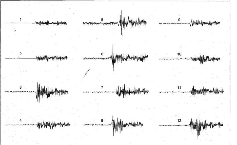
5 C. Focal Mechanism of the Earthquake Earthquake waves spread out from a point where the rupture and displacement first begin this point is called the hypocenter or the focus of the earthquake (the epicenter is the place on the surface directly above the focus. There is a distinctive pattern of first motion right around the focus, as shown below. 3D View of a Left-Lateral Strike-Slip Fault pulls away from adjacent rock, causing dilation Enlarged View of Focal Point pushes into adjacent rock, causing compression front of first P-wave View from Above Surface dilational first motion compressional first motion compressional first motion dilational first motion auxiliary plane fault plane in gray pushes into adjacent rock, causing compression pulls away from adjacent rock, causing dilation fault plane epicenter As shown in the above diagrams, the nature of the first P-wave varies from compressional to dilational as it radiates out into the four quadrants originating from the focus. Seismograms can detect this sense of motion and is recorded as either up upward first motion for compression and a downward first motion for dilation. By studying the map-view pattern of first motion recorded at various stations, you can define the four quadrants, which in turn indicate the sense of motion along the fault when the earthquake occurred. 1. Study the seismograms on the next page and determine whether the first motion is compressional or dilational, then transfer that information onto the map; darken compressional stations and draw a thin vertical line through dilational stations. 2. Based on your interpretations, find the approximate auxiliary plane and shade the compressional quadrants, then shown the relative sense of motion along the ' ' fault with some arrows ' 3 Hayward Fault 1 7 San Andreas Fault '

6
7 D. The Global Pattern of Seismicity and Plate Tectonics Seismicity occurs where rocks are being deformed under brittle ( breakable, susceptible to failure by fracturing rather than ductile flow, like silly putty) conditions, so the global distribution of reveals where deformation is occurring. As you all know by now, most seismicity is concentrated along plate boundaries, but there is quite a bit more that can be gleaned from a closer inspection of the locations of seismicity. We have loaded a huge database of earthquake foci or hypocenters onto the Geowall computer to help you see the patterns of seismicity in 3D. The questions below refer to the sub-scene called South America. Your lab assistants will show you how to start up the seismicity display. Working with your partner, study the various scenes and write short answers to the following questions. Caribbean Plate Cocos Plate 7.0 Nazca Plate 5.9 Volcanic Gap Peru - Chile Trench Volcanic Gap South American Plate 1. Study the seismicity along the South American margin. Based on the seismicity, does the subducting plate appear to be continuous or discontinuous (in both horizontal and vertical, or down-dip, directions)? Describe your observations that lead to your answer. Chile Ridge Antarctic Plate 2. a) What is the approximate relationship between the location of volcanism on the overriding plate and the dip and depth of subduction? b) Are there any differences in the subduction zone beneath the two volcanic gaps? How might these differences account for the lack of volcanism. 3. Note that all of the seismicity is not confined to the subducting plate. How might you account for the seismicity that is not in or near the subducting plate?

Name: Date: Class: Finding Epicenters and Measuring Magnitudes Worksheet
 Example Answers Name: Date: Class: Finding Epicenters and Measuring Magnitudes Worksheet Objective: To use seismic data and an interactive simulation to triangulate the location and measure the magnitude
Seismic Waves Practice
 1. Base your answer to the following question on the diagram below, which shows models of two types of earthquake waves. Model A best represents the motion of earthquake waves called 1) P-waves (compressional
Locating the Epicenter and Determining the Magnitude of an Earthquake
 Locating the and Determining the Magnitude of an Earthquake Locating the Measuring the S-P time interval There are hundreds of seismic data recording stations throughout the United States and the rest
EARTHQUAKES. Compressional Tensional Slip-strike
 Earthquakes-page 1 EARTHQUAKES Earthquakes occur along faults, planes of weakness in the crustal rocks. Although earthquakes can occur anywhere, they are most likely along crustal plate boundaries, such
DYNAMIC CRUST: Unit 4 Exam Plate Tectonics and Earthquakes
 DYNAMIC CRUST: Unit 4 Exam Plate Tectonics and Earthquakes NAME: BLOCK: DATE: 1. Base your answer to the following question on The block diagram below shows the boundary between two tectonic plates. Which
Lecture 12 Earthquake Magnitude
 Lecture 12 Earthquake Magnitude Locating Earthquakes Last time, we learned that we could obtain a rough estimate of the distance in miles to an earthquake epicenter by multiplying the S - P time interval
The earthquake source
 Global seismology: The earthquake source Reading: Fowler p111-140 and Bolt Appendix G Earthquake location Earthquake focus: Latitude, longitude, depth Earthquake epicenter: Latitude, longitude Earthquakes
Chapter 5: Earthquakes
 Chapter 5: Earthquakes 1. Experiencing an Earthquake firsthand 2. The Science of Ghost Forests and Megaearthquakes 3. Faults, Earthquakes, and Plate Tectonics 4. Seismic Waves and Earthquake Detection
Earthquakes. Earthquakes: Big Ideas. Earthquakes
 Earthquakes Earthquakes: Big Ideas Humans cannot eliminate natural hazards but can engage in activities that reduce their impacts by identifying high-risk locations, improving construction methods, and
12.510 Introduction to Seismology Spring 2008
 MIT OpenCourseWare http://ocw.mit.edu 12.510 Introduction to Seismology Spring 2008 For information about citing these materials or our Terms of Use, visit: http://ocw.mit.edu/terms. 04/30/2008 Today s
Magnitude 7.2 GUERRERO, MEXICO
 A powerful magnitude-7.2 earthquake shook central and southern Mexico on Friday. The earthquake occurred at a depth of 24 km (15 miles). Its epicenter was in the western state of Guerrero, near the seaside
Regents Questions: Plate Tectonics
 Earth Science Regents Questions: Plate Tectonics Name: Date: Period: August 2013 Due Date: 17 Compared to the oceanic crust, the continental crust is (1) less dense and more basaltic (3) more dense and
The Dynamic Crust 2) EVIDENCE FOR CRUSTAL MOVEMENT
 EVIDENCE FOR CRUSTAL MOVEMENT") The Dynamic Crust 1) Virtually everything you need to know about the interior of the earth can be found on page 10 of your reference tables. Take the time to become familiar with page 10 and everything
The Dynamic Crust 1) Virtually everything you need to know about the interior of the earth can be found on page 10 of your reference tables. Take the time to become familiar with page 10 and everything
Unit 4 Lesson 6 Measuring Earthquake Waves. Copyright Houghton Mifflin Harcourt Publishing Company
 Shake, Rattle, and Roll What happens during an earthquake? As plates of the lithosphere move, the stress on rocks at or near the edges of the plates increases. This stress causes faults to form. A fault
Geological Maps 3: Faulted Strata
 Geological Maps 3: Faulted Strata Brittle deformation in rocks is characterized by fractures, joints and faults. Fractures and joints can be of any size, orientation or pattern. Some joints form regular
Plate Tectonics: Ridges, Transform Faults and Subduction Zones
 Plate Tectonics: Ridges, Transform Faults and Subduction Zones Goals of this exercise: 1. review the major physiographic features of the ocean basins 2. investigate the creation of oceanic crust at mid-ocean
FOURTH GRADE EARTHQUAKES 1 WEEK LESSON PLANS AND ACTIVITIES
 FOURTH GRADE EARTHQUAKES 1 WEEK LESSON PLANS AND ACTIVITIES PLATE TECTONIC CYCLE OVERVIEW OF FOURTH GRADE VOLCANOES WEEK 1. PRE: Comparing different structures of volcanoes. DURING: Modeling three types
Plate Tectonics. Introduction. Boundaries between crustal plates
 Plate Tectonics KEY WORDS: continental drift, seafloor spreading, plate tectonics, mid ocean ridge (MOR) system, spreading center, rise, divergent plate boundary, subduction zone, convergent plate boundary,
Earthquakes. www.earthquakes.bgs.ac.uk
 Earthquakes www.earthquakes.bgs.ac.uk Introduction Earthquakes are among the most deadly natural hazards. There are around 100 earthquakes each year of a size that could cause serious damage. They strike
Earthquakes. www.earthquakes.bgs.ac.uk. Seismograph stations operated by the British Geological Survey
 Seismograph stations operated by the British Geological Survey Earthquakes Photograph supplied by Andy Thompson, Arup Advanced Technology, EEFIT Mission www.earthquakes.bgs.ac.uk Introduction Earthquakes
Name Date Class. By studying the Vocabulary and Notes listed for each section below, you can gain a better understanding of this chapter.
 CHAPTER 7 VOCABULARY & NOTES WORKSHEET Earthquakes By studying the Vocabulary and Notes listed for each section below, you can gain a better understanding of this chapter. SECTION 1 Vocabulary In your
Plate Tectonics Web-Quest
 Plate Tectonics Web-Quest Part I: Earth s Structure. Use the following link to find these answers: http://www.learner.org/interactives/dynamicearth/structure.html 1. Label the layers of Earth in the diagram
TECTONICS ASSESSMENT
 Tectonics Assessment / 1 TECTONICS ASSESSMENT 1. Movement along plate boundaries produces A. tides. B. fronts. C. hurricanes. D. earthquakes. 2. Which of the following is TRUE about the movement of continents?
Transform Boundaries
 Lecture 7 Plates and Mantle Plumes Transform Boundaries Transform boundaries occur where one segment of rigid lithosphere slides horizontally past another in response to stresses in the lithosphere. The
How Did These Ocean Features and Continental Margins Form?
 298 10.14 INVESTIGATION How Did These Ocean Features and Continental Margins Form? The terrain below contains various features on the seafloor, as well as parts of three continents. Some general observations
Earthquake Magnitude Calculator for the AS-1 Seismograph 1
 Magnitude calculator for the AS-1 Page 1 of 23 Earthquake Magnitude Calculator for the AS-1 Seismograph 1 Lawrence W. Braile and Saptarshi Dasgupta, Purdue University SKIP TO CALCULATORS Introduction:
THE 2004 SUMATRA EARTHQUAKE AND INDIAN OCEAN TSUNAMI: WHAT HAPPENED AND WHY
 Page 6 The Earth Scientist THE 2004 SUMATRA EARTHQUAKE AND INDIAN OCEAN TSUNAMI: WHAT HAPPENED AND WHY Seth Stein and Emile A. Okal Dept of Geological Sciences, Northwestern University, Evanston Illinois
Study Guide Questions Earth Structure and Plate Tectonics
 Study Guide Questions Earth Structure and Plate Tectonics What evidence did Alfred Wegener present in 1912 to support the idea of continental drift? Why did most geologists at the time dismiss Wegener
Magnitude 8.8 OFFSHORE MAULE, CHILE
 A great 8.8-magnitude struck central Chile early Saturday. The quake hit 200 miles (325 kilometers) southwest of the capital Santiago. The epicenter was just 70 miles (115 kilometers) from Concepcion,
Determination of source parameters from seismic spectra
 Topic Determination of source parameters from seismic spectra Authors Michael Baumbach, and Peter Bormann (formerly GeoForschungsZentrum Potsdam, Telegrafenberg, D-14473 Potsdam, Germany); E-mail: [email protected]
Earthquake Hazards and Risks
 Page 1 of 7 EENS 3050 Tulane University Natural Disasters Prof. Stephen A. Nelson Earthquake Hazards and Risks This page last updated on 28-Aug-2013 Earthquake Risk Many seismologists have said that "earthquakes
89.325 Geology for Engineers Earthquakes
 89.325 Geology for Engineers Earthquakes Name I. Introduction The crust of the earth behaves in a brittle manner. Stress is the force applied to a brittle substance and strain represents the build-up of
Glossary. continental crust: the sections of crust, the outermost layer of the earth, that include the continents
 aftershock: an earthquake that follows a larger earthquake or main shock and originates in or near the rupture zone of the larger earthquake. Generally, major earthquakes are followed by a number of aftershocks
Earthquake Magnitude
 Earthquake Magnitude Earthquake magnitude scales: Logarithmic measure of earthquake size amplitude of biggest wave: Magnitude 6 quake 10 * Magnitude 5 energy: Magnitude 6 quake is about 32 * Magnitude
Geology 112 Earthquakes. Activity 1 Worksheet Introduction to the Course. What is a Fault? What is an Earthquake?
 Geology 112 Earthquakes Name Activity 1 Worksheet Introduction to the Course. What is a Fault? What is an Earthquake? Activity 1 Objectives: Introduce student to the topics, requirements and format of
FIFTH GRADE PLATE TECTONICS 1 WEEK LESSON PLANS AND ACTIVITIES
 FIFTH GRADE PLATE TECTONICS 1 WEEK LESSON PLANS AND ACTIVITIES PLATE TECTONIC CYCLE OVERVIEW OF FIFTH GRADE VOLCANOES WEEK 1. PRE: Exploring the rocks produced by volcanoes. LAB: Comparing igneous rocks.
Activity #1-HS What is a Seismometer? High School Level
 Activity #1-HS What is a Seismometer? High School Level Objective Students will learn that a seismometer detects 3 components of motion and that a seismogram is the record of an earthquake. Background
Plate Tectonics. Plate Tectonics The unifying concept of the Earth sciences. Continental Drift
 Plate Tectonics The unifying concept of the Earth sciences. The outer portion of the Earth is made up of about 20 distinct plates (~ 100 km thick), which move relative to each other This motion is what
Geol 101: Physical Geology PAST EXAM QUESTIONS LECTURE 4: PLATE TECTONICS II
 Geol 101: Physical Geology PAST EXAM QUESTIONS LECTURE 4: PLATE TECTONICS II 4. Which of the following statements about paleomagnetism at spreading ridges is FALSE? A. there is a clear pattern of paleomagnetic
Interactive Plate Tectonics
 Interactive Plate Tectonics Directions: Go to the following website and complete the questions below. http://www.learner.org/interactives/dynamicearth/index.html How do scientists learn about the interior
Geodynamics Lecture 2 Kinematics of plate tectonics
 Geodynamics Lecture 2 Kinematics of plate tectonics Lecturer: David Whipp [email protected]! 4.9.2013 Geodynamics www.helsinki.fi/yliopisto 1 Goals of this lecture Present the three types of plate
4. Plate Tectonics II (p. 46-67)
") 4. Plate Tectonics II (p. 46-67) Seafloor Spreading In the early 1960s, samples of basaltic ocean crust were dredged up from various locations across the ocean basins. The samples were then analyzed to
4. Plate Tectonics II (p. 46-67) Seafloor Spreading In the early 1960s, samples of basaltic ocean crust were dredged up from various locations across the ocean basins. The samples were then analyzed to
Georgia Performance Standards Framework for Shaky Ground 6 th Grade
 The following instructional plan is part of a GaDOE collection of Unit Frameworks, Performance Tasks, examples of Student Work, and Teacher Commentary. Many more GaDOE approved instructional plans are
Plate tectonics states that the Earth's crust and upper mantle are broken into sections, called plates.
 Notes on Plate Tectonics Plate tectonics states that the Earth's crust and upper mantle are broken into sections, called plates. These plates move around the mantle. Plates are composed of the crust and
Earthquakes, faulting, beach-balls, magnitude scales
 Earthquakes, faulting, beach-balls, magnitude scales Faulting Geometry Faulting is a complex process and the variety of faults that exists is large. We will consider a simplified but general fault classification
Plate Tectonics: Big Ideas. Plate Tectonics. Plate Tectonics. The unifying concept of the Earth sciences.
 Plate Tectonics: Big Ideas Our understanding of Earth is continuously refined. Earth s systems are dynamic; they continually react to changing influences from geological, hydrological, physical, chemical,
Using Google Earth to Explore Plate Tectonics
 Using Google Earth to Explore Plate Tectonics Laurel Goodell, Department of Geosciences, Princeton University, Princeton, NJ 08544 [email protected] Inspired by, and borrows from, the GIS-based Exploring
Plate Tectonics Lab. Continental Drift. The Birth of Plate Tectonics
 Plate Tectonics Lab Continental Drift Take a look at a globe sometime and observe the remarkable fit between South America and Africa. Could they have, in fact, been connected? During the 19th and early
Presentations. Session 1. Slide 1. Earthquake Risk Reduction. 1- Concepts & Terminology
 Earthquake Risk Reduction Presentations Session 1 Slide 1 Earthquake Risk Reduction 1- Concepts & Terminology Welcome to the World Bank Institute s (WBI) Distance Learning (DL) course on Earthquake Risk
ES Chapter 10 Review. Name: Class: Date: Multiple Choice Identify the choice that best completes the statement or answers the question.
 Name: Class: Date: ES Chapter 10 Review Multiple Choice Identify the choice that best completes the statement or answers the question. 1. Scientists used the pattern of alternating normal and reversed
Tectonic plates push together at convergent boundaries.
 KEY CONCEPT Plates converge or scrape past each other. BEFORE, you learned Plates move apart at divergent boundaries In the oceans, divergent boundaries mark where the sea floor spreads apart On land,
1. The diagram below shows a cross section of sedimentary rock layers.
 1. The diagram below shows a cross section of sedimentary rock layers. Which statement about the deposition of the sediments best explains why these layers have the curved shape shown? 1) Sediments were
Continental Drift, Sea Floor Spreading and Plate Tectonics
 Page 1 of 13 EENS 1110 Tulane University Physical Geology Prof. Stephen A. Nelson Continental Drift, Sea Floor Spreading and Plate Tectonics This page last updated on 26-Aug-2015 Plate Tectonics is a theory
Chapter 7 Earthquake Hazards Practice Exam and Study Guide
 Chapter 7 Earthquake Hazards Practice Exam and Study Guide 1. Select from the following list, all of the factors that affect the intensity of ground shaking. a. The magnitude of the earthquake b. Rather
FOURTH GRADE PLATE TECTONICS 1 WEEK LESSON PLANS AND ACTIVITIES
 FOURTH GRADE PLATE TECTONICS 1 WEEK LESSON PLANS AND ACTIVITIES PLATE TECTONIC CYCLE OVERVIEW OF FOURTH GRADE VOLCANOES WEEK 1. PRE: Comparing different structures of volcanoes. LAB: Modeling three types
II. Earth Science (Geology) Section (9/18/2013)
 Section (9/18/2013)") EAPS 100 Planet Earth Lecture Topics Brief Outlines II. Earth Science (Geology) Section (9/18/2013) 1. Interior of the Earth Learning objectives: Understand the structure of the Earth s interior crust,
EAPS 100 Planet Earth Lecture Topics Brief Outlines II. Earth Science (Geology) Section (9/18/2013) 1. Interior of the Earth Learning objectives: Understand the structure of the Earth s interior crust,
Unit: Restless Earth Lesson: Earth s Interior
 Melissa Duran, Hoover Middle School, San Jose, CA 1/9/03 Bay Area Science Museum Collaboratory Project Unit: Restless Earth Lesson: Earth s Interior Introduction Standards: 1.b, 7.e Objectives Students
How do scientists measure earthquakes?
 Name: Source: http://www.scholastic.com/browse/article.jsp?id=4892 http://gizmodo.com/5833688/what-do-earthquake-magnitudes-mean http://www.kids-fun-science.com/moment-magnitude-scale.html http://tremor.nmt.edu/faq/how.html
EARTHQUAKE MAGNITUDE
 EARTHQUAKE MAGNITUDE Earliest measure of earthquake size Dimensionless number measured various ways, including M L local magnitude m b body wave magnitude M s surface wave magnitude M w moment magnitude
Plate Tectonics Practice Questions and Answers Revised August 2007
 Plate Tectonics Practice Questions and Answers Revised August 2007 1. Please fill in the missing labels. 2. Please fill in the missing labels. 3. How many large plates form the outer shell of the earth?
Chapter 8: Plate Tectonics -- Multi-format Test
 Name: Class: Date: ID: A Chapter 8: Plate Tectonics -- Multi-format Test Modified True/False Indicate whether the statement is true or false. If false, change the identified word or phrase to make the
SIXTH GRADE PLATE TECTONICS 1 WEEK LESSON PLANS AND ACTIVITIES
 SIXTH GRADE PLATE TECTONICS 1 WEEK LESSON PLANS AND ACTIVITIES PLATE TECTONIC CYCLE OVERVIEW OF SIXTH GRADE VOLCANOES WEEK 1. PRE: Comparing the structure of different types of volcanoes. LAB: Plotting
Dip is the vertical angle perpendicular to strike between the imaginary horizontal plane and the inclined planar geological feature.
 Geological Visualization Tools and Structural Geology Geologists use several visualization tools to understand rock outcrop relationships, regional patterns and subsurface geology in 3D and 4D. Geological
Tsunami Practice Questions and Answers Revised November 2008
 Tsunami Practice Questions and Answers Revised November 2008 1. What happened on 26 December 2004 off the west coast of Sumatra? 2. What is the final estimate of the magnitude of the Sumatra 26 December
Seismographs. Lesson 7. Seismographs recording activity on Kilauea
 Seismographs Lesson 7 E arthquakes generate seismic waves that travel all around the world and can be detected by sensitive instruments called seismographs. The earliest instrument to detect earthquakes
Plate Tectonics Short Study Guide
 Name: Class: Date: Plate Tectonics Short Study Guide Multiple Choice Identify the letter of the choice that best completes the statement or answers the question. 1. The existence of coal beds in Antarctica
Building 1D reference velocity model of the Irpinia region (Southern Apennines): microearthquakes locations and focal mechanism
: microearthquakes locations and focal mechanism") Building 1D reference velocity model of the Irpinia region (Southern Apennines): microearthquakes locations and focal mechanism Tutor Prof. Raffaella De Matteis PhD student Emanuela Matrullo Geophisics
Building 1D reference velocity model of the Irpinia region (Southern Apennines): microearthquakes locations and focal mechanism Tutor Prof. Raffaella De Matteis PhD student Emanuela Matrullo Geophisics
Investigation 6: What happens when plates collide?
 Tectonics Investigation 6: Teacher Guide Investigation 6: What happens when plates collide? In this activity, students will use the distribution of earthquakes and volcanoes in a Web GIS to learn about
Step 2: Learn where the nearest divergent boundaries are located.
 What happens when plates diverge? Plates spread apart, or diverge, from each other at divergent boundaries. At these boundaries new ocean crust is added to the Earth s surface and ocean basins are created.
EARTHQUAKE PREDICTION
 Lecture 15 Earthquake Prediction EARTHQUAKE PREDICTION To successfully predict an earthquake we would like to know:- PLACE TIME MAGNITUDE (rather like a weather forecast) 1 Evidence must be integrated
Chapter 2. Plate Tectonics. Plate Tectonics: Learning Goals
 Plate Tectonics Chapter 2 Interactions at depend on the direction of relative plate motion and the type of crust. Which kind of plate boundary is associated with Earthquake activity? A. Divergent Boundary
Hot Spots & Plate Tectonics
 Hot Spots & Plate Tectonics Activity I: Hawaiian Islands Procedures: Use the map and the following information to determine the rate of motion of the Pacific Plate over the Hawaiian hot spot. The volcano
The seismic activity in the area of Greece between 1966 and 1969
 The seismic activity in the area of Greece between 1966 and 1969 P. A. GIANNAKOPOULOS * Received on March 28'", 1972 SUMMARY. The earthquake activity in the area of Greece for the years 1966, 1967, 1968
Name: Period: # Plate Tectonics. Journey to the center of the Earth
 Plate Tectonics Journey to the center of the Earth Use pages 124 129 to answer the following questions. Exploring Inside Earth (p. 125-126) 1. What are the two main types of evidence that Geologist use
DEEP AZIMUTHAL SEISMIC ANISOTROPY IN THE WESTERNANATOLIA AND AEGEAN SUBDUCTION ZONE
 DEEP AZIMUTHAL SEISMIC ANISOTROPY IN THE WESTERNANATOLIA AND AEGEAN SUBDUCTION ZONE G. Polat -1 and M.N. Ozel -1 Adress: 1- Boğaziçi University, Kandilli Observatory and Earthquake Research Institution,
Reading GPS Time Series Plots Worksheet
 Reading GPS Time Series Plots Worksheet By: Roger Groom and Cate Fox-Lent, UNAVCO Master Teachers in-residence, Shelley Olds, UNAVCO The Global Positioning System, GPS, is used to study the Earth, how
The interior of the Earth is divided into layers based on chemical and physical properties.
 Plate Tectonics Lecture Notes: Slide 1. Title Slide Slide 2. The interior of the Earth is divided into layers based on chemical and physical properties. The Earth has an outer silica-rich, solid crust,
6.E.2.2 Plate Tectonics, Earthquakes and Volcanoes
 Name: Date: 1. The road shown below was suddenly broken by a natural event. 3. The convergence of two continental plates would produce Which natural event most likely caused the crack in the road? island
Plate Tectonics. Learning Guide. Pacific Plate. Pacific Ocean. Divergent boundaries
 Plate Tectonics Learning Guide North American Plate Eurasian Plate Arabian Plate Pacific Plate Atlantic Ocean Pacific Ocean Cocos Plate Nazca Plate South American Plate African Plate Convergent boundary
Earthquakes. Was anyone hur t? 358 Chuck Nacke/TimeLife Pictures/Getty Images
 Academic Standard 3: Students collect and organize data to identify relationships between physical objects, events, and processes. They use logical reasoning to question their own ideas as new information
Continental Drift. Alfred Wegener (1880-1930) Proposed that all of the continents were once part of a large supercontinent - Pangaea Based on:
 Proposed that all of the continents were once part of a large supercontinent - Pangaea Based on:") Plate Tectonics and Continental Drift Continental Drift Alfred Wegener (1880-1930) Proposed that all of the continents were once part of a large supercontinent - Pangaea Based on: Similarities in shorelines
Plate Tectonics and Continental Drift Continental Drift Alfred Wegener (1880-1930) Proposed that all of the continents were once part of a large supercontinent - Pangaea Based on: Similarities in shorelines
Introduction to Plate Tectonics via Google Earth
 Introduction to Plate Tectonics via Google Earth Plate tectonics is a unifying framework for understanding the dynamic geology of the Earth. The theory posits that the outermost layers of the Earth (the
Earthquakes: Interesting Facts and F.A.Q.
 Earthquakes: Interesting Facts and F.A.Q. Earthquakes kill approximately 8,000 people each year and have caused an estimated 13 million deaths in the past 4,000 years. The moment magnitude scale (MMS)
Laboratory #8: Structural Geology Thinking in 3D
 Name: Lab day: Tuesday Wednesday Thursday ENVG /SC 10110-20110L Planet Earth Laboratory Laboratory #8: Structural Geology Thinking in 3D http://www.nd.edu/~cneal/physicalgeo/lab-structural/index.html Readings:
Location and Distance on Earth (Chapter 22 part 1)
") GEOLOGY 306 Laboratory Instructor: TERRY J. BOROUGHS NAME: Location and Distance on Earth (Chapter 22 part 1) For this assignment you will require: a calculator, protractor, and a metric ruler, and an
GEOLOGY 306 Laboratory Instructor: TERRY J. BOROUGHS NAME: Location and Distance on Earth (Chapter 22 part 1) For this assignment you will require: a calculator, protractor, and a metric ruler, and an
LABORATORY TWO GEOLOGIC STRUCTURES
 EARTH AND ENVIRONMENT THROUGH TIME LABORATORY- EES 1005 LABORATORY TWO GEOLOGIC STRUCTURES Introduction Structural geology is the study of the ways in which rocks or sediments are arranged and deformed
Geometric Optics Converging Lenses and Mirrors Physics Lab IV
 Objective Geometric Optics Converging Lenses and Mirrors Physics Lab IV In this set of lab exercises, the basic properties geometric optics concerning converging lenses and mirrors will be explored. The
Plate Tectonics Chapter 2
 Plate Tectonics Chapter 2 Does not include complete lecture notes. Continental drift: An idea before its time Alfred Wegener First proposed his continental drift hypothesis in 1915 Published The Origin
Pore pressure. Ordinary space
 Fault Mechanics Laboratory Pore pressure scale Lowers normal stress, moves stress circle to left Doesn Doesn t change shear Deviatoric stress not affected This example: failure will be by tensile cracks
Earthquakes Natural and Induced. Rick Aster Professor of Geophysics and Department Head Geosciences Department Colorado State University
 Earthquakes Natural and Induced Rick Aster Professor of Geophysics and Department Head Geosciences Department Colorado State University Overview What causes earthquakes? How do we detect, locate, and measure
Using Remotely Sensed Data From ASTER to Look Impact of Recent Earth Quakes in Gujarat, India.
 Using Remotely Sensed Data From ASTER to Look Impact of Recent Earth Quakes in Gujarat, India. A major earth quake occurred in Gujarat, India on January 26,2000. (Origin time 03:16 GMT, Location 23.399N
Inside Earth Chapter 3
 Name Hour Due Date Inside Earth Chapter Page 1 Volcanoes and Plate Tectonics Page 2 Volcanic Activity Page - Mapping Earthquakes and Volcanoes Page 4 Mapping Earthquakes and Volcanoes table Page 5 - Mapping
Shake, Rattle, and Roll. Tina Moore, Denise Robinette, & Matt Utz
 Shake, Rattle, and Roll Tina Moore, Denise Robinette, & Matt Utz Shake, Rattle, and Roll - Earthquakes Lesson Plan - Day One I. Objective: A. Student will be able to read and label a two axis graph. B.
Plotting Earthquake Epicenters an activity for seismic discovery
 Plotting Earthquake Epicenters an activity for seismic discovery Tammy K Bravo Anne M Ortiz Plotting Activity adapted from: Larry Braile and Sheryl Braile Department of Earth and Atmospheric Sciences Purdue
GEOLOGIC MAPS. PURPOSE: To be able to understand, visualize, and analyze geologic maps
 GEOLOGIC MAPS PURPOSE: To be able to understand, visualize, and analyze geologic maps Geologic maps show the distribution of the various igneous, sedimentary, and metamorphic rocks at Earth s surface in
SUMMARY OF MAGNITUDE WORKING GROUP RECOMMENDATIONS ON DETERMINING EARTHQUAKE MAGNITUDES FROM DIGITAL DATA
 B SUMMARY OF MAGNITUDE WORKING GROUP RECOMMENDATIONS ON DETERMINING EARTHQUAKE MAGNITUDES FROM DIGITAL DATA The Working Group on Magnitudes (Magnitude WG) of the International Association of Seismology
ABSG Consulting, Tokyo, Japan Email: [email protected] 2. Professor, Kogakuin University, Tokyo, Japan 3
 Application of Earthquake Early Warning System and Real-time Strong-motion Monitoring System to Earthquake Disaster Mitigation of a High-Rise Building in Tokyo, Japan Tomohiro Kubo 1, Yoshiaki Hisada 2,
LAB 2 SUPPLEMENT: THE JULES VERNE VOYAGER, JR.
 LAB 2 SUPPLEMENT: THE JULES VERNE VOYAGER, JR. For this section of the lab we will be using a very cool web-based map tool that provides access to an amazing suite of state-of-the-art scientific observations
1 Introduction. External Grant Award Number: 04HQGR0038. Title: Retrieval of high-resolution kinematic source parameters for large earthquakes
 External Grant Award Number: 04HQGR0038 Title: Retrieval of high-resolution kinematic source parameters for large earthquakes Author: Hong Kie Thio URS Group Inc. 566 El Dorado Street, 2 nd floor Pasadena,