GEOLOGIC MAPS. PURPOSE: To be able to understand, visualize, and analyze geologic maps
|
|
|
- Roxanne Gilmore
- 9 years ago
- Views:
Transcription
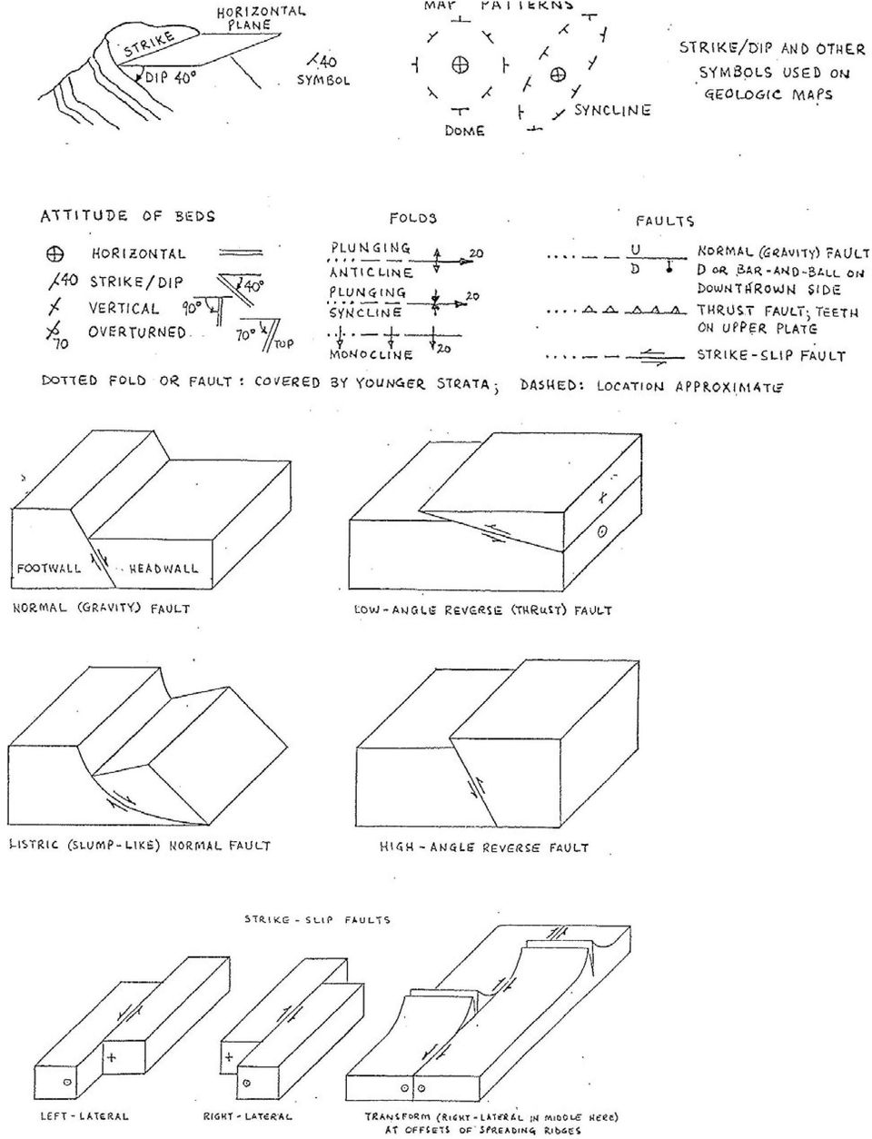
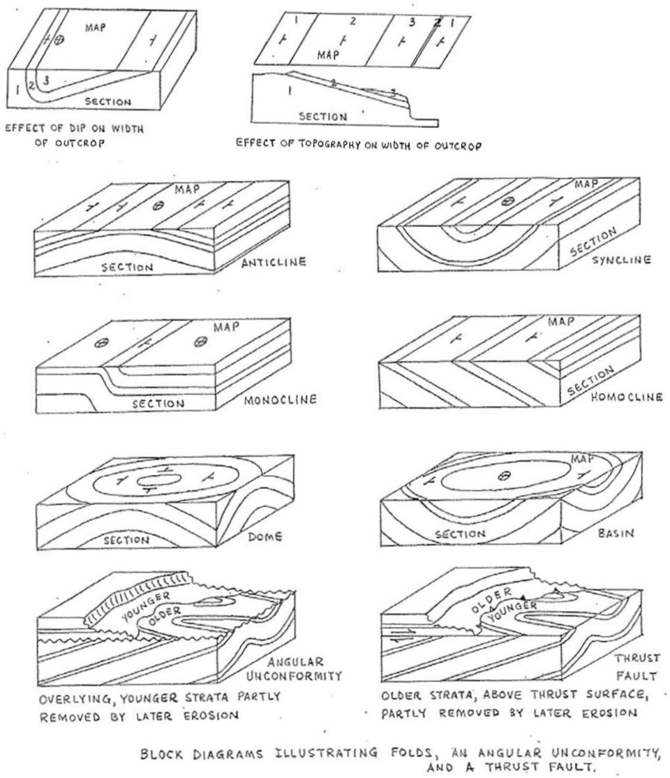
1 GEOLOGIC MAPS PURPOSE: To be able to understand, visualize, and analyze geologic maps Geologic maps show the distribution of the various igneous, sedimentary, and metamorphic rocks at Earth s surface in plan view. The contacts between different geologic formations and the various structures that occur in the rocks are typically superimposed upon the contour lines of topography in the map area. Geologic cross sections often appear with geologic maps. They are diagrams illustrating the distribution of geologic units in the vertical dimension along a line through the map area. They may also show the topographic profile of the land surface. Map Explanations or Keys are also found accompanying geologic maps. The formations are presented and described in chronological sequence, with the oldest unit at the bottom and the youngest unit at the top. Geologic maps make use of specific map symbols to relate important information. Illustrations of common structure symbols and fault/fold relations are on pages 2 and 3. Useful items on geologic maps: The symbol for a geologic unit, labeled on the map and in the explanation, begins with the capitalized symbol for the geologic period (or era), followed by lowercase letters that designate the name of the formation. for example, the Ordovician Swan Peak Formation is labeled Osp Contact lines on a map separate and mark the boundary between two adjacent geologic formations. Outcrops are those places where a geologic formation is exposed at the Earth s surface. Three factors control the width of a formation s outcrop on a geologic map: 1) the formation s thickness; 2) the slope of the land in the area of an outcrop; and 3) the dip angle of the beds in the formation. The dip angle, measured in degrees, is the maximum angle between an imaginary horizontal plane and the sloping bedding plane of sedimentary strata. The direction of dip is the compass bearing that the rock units are tilted towards, measured downwards from the horizontal. The line of strike is the direction of the intersection of an imaginary horizontal plane and a tilted bedding plane or contact. The direction of strike is always at a right angle to the direction of dip. Fold symbols are a line along the crest of an anticline, trough of a syncline, or the inflection along a monocline. The type of fold is indicated by arrows across this line: pointing outward for an anticline, inward for a syncline, and in the direction of the step down for a monocline.

2
3
4 Exercise Part 1 (do before lab): Visualizing Geology in 3-D with online program tasks/questions in italics will be graded We are going to explore the block-diagrams provided on the previous pages in 3-D by exploring this site: Go to Click on Visualize, then click on View Models. We ll begin by looking at blocks that have already been created, then later we can explore building our own block models. 1. a) Select normal fault. Rotate the model so that you observe the block from all angles. Draw a small sketch of the normal fault from both a top view and a side view. Label the footwall and the hanging wall (aka headwall ): b) Select reverse fault. Rotate the model so that you observe the block from all angles. Sketch the reverse fault from a top view and a side view, labeling the footwall and the hanging wall: c) Compare the two sets of drawings you just made. Explain how you differentiate the two faults from each other based on your illustrations. 2. a) Select syncline and rotate the model so that you observe the block from all angles. Now, select anticline and rotate the model. Finally, select plunging anticline and do the same. b) Sketch here the top and a side view of a syncline and the plunging anticline, label the oldest strata and the youngest strata on you diagrams:

5 c) Describe the similarities and differences between these two folds and how you use the ages of the rock layers to differentiate them. Next, hit the back button on your browser and go back to the Visible Geology starting page to clear things and start over with a new block by clicking again on Visualize. This time stay on Create Geology, and select Geologic Beds and create a new geology block with at least 3 layers of your choosing. Edit the 3 layers to fit the block, the total is 86 units high, so for example: layer 1 = 32, layer 2 = 24, and layer 3 = 30 units to fill the whole block. 3. Now create a dome, selecting the Domes and Basins icon. Begin by setting the radius at 30, and then Add Dome Event to deform your block. The events are incremental, so you should do 3 events in a row to make the pattern really visible. Rotate the block so that you observe it from all angles. Play around with the radius to see how it affects your dome. 4. Geologic maps often display patterns that are far more complex than those we have seen so far in these block models. Geologists spend a lot of their time and brain-power trying to unravel the events that created the complex geology we observe in the landscape. You will now create some very complex map patterns. a) Folding folds. Create a simple fold in your basic layered block model: 000 strike, 90 dip, 000 rake, and under More Options : 90 period, 20 amplitude. Examine your block from all angles. It should look very familiar. Now, simply change the strike to 045 and the dip to 70 and add new folding event. Examine your block diagram. When looking at just the top, like in a Geologic Map, what previous structure in this exercise does the pattern roughly resemble? Now lets add a 3 rd folding event. Change the strike to 090, the dip to 50, and the period to 30. Sketch here the top (map view) and the east-side (cross section view):

6 a) Click on Geologic History, and delete these three folding events to get back to your simple layers. Go back to Create Geology and let s begin by tilting the beds at the default dip of 45 degrees. Now, go back to the Create Geology menu and add a Simple Unconformity using the default settings. This block should look familiar. Continuing to build on this tilted model, let s go ahead and fault it as well. Click on Fault, and go with a strike of 30 and a dip of 35, and under More Options, make it have a slip of 25. Finally, add a folding event to this block. Make the fold strike 060, have a dip of 90, and (under More Options) have a period of 090. Whew! You can go back to Geologic History to remember your 4 deformation events. Please sketch here the map view and the east-side cross-section view. Which line is the fault? Can you put a symbol on it showing which side is down along the fault line? Which line is the unconformity? Can you label it? Extra bonus if you can correctly label the oldest to youngest beds in your deformed block. 5. Keeping your complicated block model, open the Explore tab at the top right. In this menu, you can make cross-sectional views (like at the sides of your block) in any direction you want it is nifty. Now, drill a borehole in the middle of your block. Check it out. This is the amount of information an exploration geologist generally receives to work from. Imagine trying to interpret the complicated geologic history of an area with such a narrow tube of rock! With a few more boreholes, and geologic training, you could do it!
 have a period of 090. Whew!")
7 Exercise Part 2: Inspecting Geologic maps in the lab room Sugar House 1. Focusing on the bedrock underlying the Wasatch Mtns of the eastern 1/3 of map... a) What type of fold structure parallels Parley s Canyon (northeast part of map)? b) Compare (list) the bedrock ages along the axis of the fold, versus to the south along the limb, towards Mill Canyon which is older? 2. Observe the fault that lies parallel to the mountain front in the southern part of the map, within the yellow Qu map unit. a) Which side of the fault, generally, is down-thrown? What type of fault is this? b) The fault is shown as cross-cutting and offsetting the Qu map unit. How old is the fault activity? Bright Angel Arizona 3. Looking at the contact lines shown between Paleozoic geologic units, relative to the topographic contours--what is the general dip or tilt of the bedrock units? 4. Taken on the south side of Grand Canyon, what is the thickness of the Paleozoic rocks exposed? 5. What type of unconformity exists between the Zoroaster Granite, the Bright Angel, and the Tapeats formations south of Bradley Point (in east-central part of map)? 6. Observe the Pipe fault where it crosses the small drainage south of Isis Temple (west-central part of map): a) Constrain the geologic age of the Pipe fault, considering the geologic formations it does and does not cross-cut:
 Which side of the fault, generally, is down-thrown?")
8 b) Considering the direction that the fault line Vs as it crosses the drainage, what direction does this fault surface dip? c) What kind of fault is this? Flaming Gorge 7. North of the Uinta fault, which runs east-west through the center of the map area a) What rock types (not specific unit names) form the high plateaus, ridges, and steep cliffs, such as the Boars Tusk and the steep cliffs in Horseshoe Canyon? b) What bedrock type underlies the broader valleys, such as Antelope Flat and Lucerne Valley? c) Hypothesize why this would be: 8. a) The rock south of the Uinta fault is of what geologic age? Compare this to the age range of rocks immediately north of the fault: b) Using the symbols along the fault line, which side of the fault is up-thrown? c) Based upon these observations, what type of fault is the Uinta fault? d) Due to movement on the Uinta fault, the rocks north of the fault are broadly bent into what type of fold? 9. Based upon your observations from question 8, and using cross cutting relations, constrain the geologic timing of Uinta fault activity as best you can. Explain your reasoning!
 The rock south of the Uinta fault is of what geologic age?")
LABORATORY TWO GEOLOGIC STRUCTURES
 EARTH AND ENVIRONMENT THROUGH TIME LABORATORY- EES 1005 LABORATORY TWO GEOLOGIC STRUCTURES Introduction Structural geology is the study of the ways in which rocks or sediments are arranged and deformed
Dip is the vertical angle perpendicular to strike between the imaginary horizontal plane and the inclined planar geological feature.
 Geological Visualization Tools and Structural Geology Geologists use several visualization tools to understand rock outcrop relationships, regional patterns and subsurface geology in 3D and 4D. Geological
Map Patterns and Finding the Strike and Dip from a Mapped Outcrop of a Planar Surface
 Map Patterns and Finding the Strike and Dip from a Mapped Outcrop of a Planar Surface Topographic maps represent the complex curves of earth s surface with contour lines that represent the intersection
Laboratory #8: Structural Geology Thinking in 3D
 Name: Lab day: Tuesday Wednesday Thursday ENVG /SC 10110-20110L Planet Earth Laboratory Laboratory #8: Structural Geology Thinking in 3D http://www.nd.edu/~cneal/physicalgeo/lab-structural/index.html Readings:
USING RELATIVE DATING AND UNCONFORMITIES TO DETERMINE SEQUENCES OF EVENTS
 EARTH AND ENVIRONMENT THROUGH TIME LABORATORY- EES 1005 LABORATORY THREE USING RELATIVE DATING AND UNCONFORMITIES TO DETERMINE SEQUENCES OF EVENTS Introduction In order to interpret Earth history from
Structural Geology Laboratory 9 (Name)
") Structural Geology Laboratory 9 (Name) Geologic maps show the distribution of different types of structures and rock stratigraphic units generally on a topographic base such as a quadrangle map. Key structures
Structural Geology Laboratory 9 (Name) Geologic maps show the distribution of different types of structures and rock stratigraphic units generally on a topographic base such as a quadrangle map. Key structures
Location and Distance on Earth (Chapter 22 part 1)
") GEOLOGY 306 Laboratory Instructor: TERRY J. BOROUGHS NAME: Location and Distance on Earth (Chapter 22 part 1) For this assignment you will require: a calculator, protractor, and a metric ruler, and an
GEOLOGY 306 Laboratory Instructor: TERRY J. BOROUGHS NAME: Location and Distance on Earth (Chapter 22 part 1) For this assignment you will require: a calculator, protractor, and a metric ruler, and an
Geological Maps 1: Horizontal and Inclined Strata
 Geological Maps 1: Horizontal and Inclined Strata A well-rounded geologist must be familiar with the processes that shape the Earth as well as the rocks and minerals that comprise it. These processes cover
Geologic History Review
 1. The climate that existed in an area during the early Paleozoic Era can best be determined by studying (1) the present climate of the area (2) recorded climate data of the area since 1700 (3) present
Geology and Landscapes 2014 Maps and cross-sections
 Geology and Landscapes 2014 Maps and cross-sections Practicals 2 to 9 will be dedicated to the study of geological maps and the production of geological cross-section. Below is a summary of the different
Introduction to Structural Geology
 Introduction to Structural Geology Workbook 3 Geological Maps BGS Introduction to geological maps 4 1. Outcrop patterns on geological maps 7 2. Cross sections 16 3. Structure contours 22 cknowledgements
STRUCTURAL GEOLOGY LABORATORY MANUAL
 STRUCTURAL GEOLOGY LABORATORY MANUAL Fourth Edition by David T. Allison Copyright 2015 Associate Professor of Geology Department of Earth Sciences University of South Alabama TABLE OF CONTENTS LABORATORY
Geological Maps 3: Faulted Strata
 Geological Maps 3: Faulted Strata Brittle deformation in rocks is characterized by fractures, joints and faults. Fractures and joints can be of any size, orientation or pattern. Some joints form regular
89.215 - FORENSIC GEOLOGY GEOLOGIC TIME AND GEOLOGIC MAPS
 NAME 89.215 - FORENSIC GEOLOGY GEOLOGIC TIME AND GEOLOGIC MAPS I. Introduction There are two types of geologic time, relative and absolute. In the case of relative time geologic events are arranged in
Stratigraphic Cross Sections Why study old rocks?
 rom IRIS collection: Animations of eologic Processes www.iris.edu/educate/animations Stratigraphic ross Sections Why study old rocks? The earthquake potential of an area can be determined by studying the
Roof Tutorial. Chapter 3:
 Chapter 3: Roof Tutorial The majority of Roof Tutorial describes some common roof styles that can be created using settings in the Wall Specification dialog and can be completed independent of the other
How Did These Ocean Features and Continental Margins Form?
 298 10.14 INVESTIGATION How Did These Ocean Features and Continental Margins Form? The terrain below contains various features on the seafloor, as well as parts of three continents. Some general observations
Petrel TIPS&TRICKS from SCM
 Petrel TIPS&TRICKS from SCM Maps: Knowledge Worth Sharing Map Annotation A map is a graphic representation of some part of the earth. In our industry, it may represent either the surface or sub surface;
Experiment 5: Magnetic Fields of a Bar Magnet and of the Earth
 MASSACHUSETTS INSTITUTE OF TECHNOLOGY Department of Physics 8.02 Spring 2005 Experiment 5: Magnetic Fields of a Bar Magnet and of the Earth OBJECTIVES 1. To examine the magnetic field associated with a
Plate Tectonics: Ridges, Transform Faults and Subduction Zones
 Plate Tectonics: Ridges, Transform Faults and Subduction Zones Goals of this exercise: 1. review the major physiographic features of the ocean basins 2. investigate the creation of oceanic crust at mid-ocean
Sample Table. Columns. Column 1 Column 2 Column 3 Row 1 Cell 1 Cell 2 Cell 3 Row 2 Cell 4 Cell 5 Cell 6 Row 3 Cell 7 Cell 8 Cell 9.
 Working with Tables in Microsoft Word The purpose of this document is to lead you through the steps of creating, editing and deleting tables and parts of tables. This document follows a tutorial format
Laboratory 6: Topographic Maps
 Name: Laboratory 6: Topographic Maps Part 1: Construct a topographic map of the Egyptian Pyramid of Khafre A topographic map is a two-dimensional representation of a three-dimensional space. Topographic
Basic AutoSketch Manual
 Basic AutoSketch Manual Instruction for students Skf-Manual.doc of 3 Contents BASIC AUTOSKETCH MANUAL... INSTRUCTION FOR STUDENTS... BASIC AUTOSKETCH INSTRUCTION... 3 SCREEN LAYOUT... 3 MENU BAR... 3 FILE
Lecture Outlines PowerPoint. Chapter 11 Earth Science, 12e Tarbuck/Lutgens
 Lecture Outlines PowerPoint Chapter 11 Earth Science, 12e Tarbuck/Lutgens 2009 Pearson Prentice Hall This work is protected by United States copyright laws and is provided solely for the use of instructors
SolidWorks: Mirror, Revolve, and. Introduction to Robotics
 SolidWorks: Mirror, Revolve, and Circular Pattern Introduction to Robotics Let s Review At this point we have learned the following: Extrude Boss/Base Extruded Cut Adding Relations and Dimensions Linear
Understand the Sketcher workbench of CATIA V5.
 Chapter 1 Drawing Sketches in Learning Objectives the Sketcher Workbench-I After completing this chapter you will be able to: Understand the Sketcher workbench of CATIA V5. Start a new file in the Part
CATIA Drafting TABLE OF CONTENTS
 TABLE OF CONTENTS Introduction...1 Drafting...2 Drawing Screen...3 Pull-down Menus...4 File...4 Edit...5 View...6 Insert...7 Tools...8 Drafting Workbench...9 Views and Sheets...9 Dimensions and Annotations...10
MET 306. Activity 8a. Mechanism Design Creo 2.0 Level 7 POINT A GROUND LINK LINK 1 LINK 2 LINK 3 POINT B 10/15/2010 1
 Mechanism Design Creo 2.0 Level 7 POINT A LINK 1 GROUND LINK LINK 2 LINK 3 POINT B 10/15/2010 1 Download parts ground, key, link_1, link_2, link_3 and pulley from the V:/MET_306/Activity_8_Creo drive.
Applying a circular load. Immediate and consolidation settlement. Deformed contours. Query points and query lines. Graph query.
 Quick Start Tutorial 1-1 Quick Start Tutorial This quick start tutorial will cover some of the basic features of Settle3D. A circular load is applied to a single soil layer and settlements are examined.
1051-232 Imaging Systems Laboratory II. Laboratory 4: Basic Lens Design in OSLO April 2 & 4, 2002
 05-232 Imaging Systems Laboratory II Laboratory 4: Basic Lens Design in OSLO April 2 & 4, 2002 Abstract: For designing the optics of an imaging system, one of the main types of tools used today is optical
Principles of groundwater flow
 Principles of groundwater flow Hydraulic head is the elevation to which water will naturally rise in a well (a.k.a. static level). Any well that is not being pumped will do for this, but a well that is
Microsoft Excel 2010 Charts and Graphs
 Microsoft Excel 2010 Charts and Graphs Email: [email protected] Web Page: http://training.health.ufl.edu Microsoft Excel 2010: Charts and Graphs 2.0 hours Topics include data groupings; creating
SolidWorks Tutorial 3 MAGNETIC BLOCK
 SolidWorks Tutorial 3 MAGNETIC BLOCK Magnetic Block In this exercise you will make a magnetic block. To do so, you will create a few parts, which you will assemble. You will learn the following new applications
Surface Machining. NATIONAL INSTITUTE FOR AVIATION RESEARCH Wichita State University. Revision 5.13 Copyright 2004. All rights reserved.
 Surface Machining NATIONAL INSTITUTE FOR AVIATION RESEARCH Wichita State University Revision 5.13 Copyright 2004. All rights reserved. www.cadcamlab.org None of this material may be reproduced, used or
Geologic time and dating. Geologic time refers to the ages relevant to Earth s history
 Geologic time and dating Most figures and tables contained here are from course text: Understanding Earth Fourth Edition by Frank Press, Raymond Siever, John Grotzinger, and Thomas H. Jordan Geologic time
Mastercam X6 Basic 3D Design
 Basic 3D Design mastercam x getting started tutorials Mastercam X6 Basic 3D Design December 2011 Be sure you have the latest information! Information might have been changed or added since this document
Rock Cycle Part I Student Guide
 Rock Cycle Part I Student Guide Write your answers on the separate answer sheet provided. Introduction Why are there different kinds of rock on Earth? Earth rocks are recycled so that new rock is constantly
CATIA Functional Tolerancing & Annotation TABLE OF CONTENTS
 TABLE OF CONTENTS Introduction...1 Functional Tolerancing and Annotation...2 Pull-down Menus...3 Insert...3 Functional Tolerancing and Annotation Workbench...4 Bottom Toolbar Changes...5 3D Grid Toolbar...5
CATIA Wireframe & Surfaces TABLE OF CONTENTS
 TABLE OF CONTENTS Introduction... 1 Wireframe & Surfaces... 2 Pull Down Menus... 3 Edit... 3 Insert... 4 Tools... 6 Generative Shape Design Workbench... 7 Bottom Toolbar... 9 Tools... 9 Analysis... 10
Tectonic plates push together at convergent boundaries.
 KEY CONCEPT Plates converge or scrape past each other. BEFORE, you learned Plates move apart at divergent boundaries In the oceans, divergent boundaries mark where the sea floor spreads apart On land,
CATIA Basic Concepts TABLE OF CONTENTS
 TABLE OF CONTENTS Introduction...1 Manual Format...2 Log on/off procedures for Windows...3 To log on...3 To logoff...7 Assembly Design Screen...8 Part Design Screen...9 Pull-down Menus...10 Start...10
STRUCTURAL GEOLOGY LABORATORY MANUAL
 STRUCTURAL GEOLOGY LABORATORY MANUAL Fourth Edition by David T. Allison Copyright 2013 Associate Professor of Geology Department of Earth Sciences University of South Alabama TABLE OF CONTENTS LABORATORY
Roof Tutorial. Chapter 3:
 Chapter 3: Roof Tutorial The first portion of this tutorial can be completed independent of the previous tutorials. We ll go over some common roof styles that can be created using settings in the Wall
principles of stratigraphy: deposition, succession, continuity and correlation
 Relative Age Dating Comparative Records of Time Nature of the rock record principles of stratigraphy: deposition, succession, continuity and correlation Stratigraphic tools biological succession of life:
A Guide to Writing a Geological Map Report in ESS241
 A Guide to Writing a Geological Map Report in ESS241 Allison Enright and Charly Bank Department of Earth Sciences University of Toronto Abstract Your abstract should be a stand-alone summary of your report,
1. Kyle stacks 30 sheets of paper as shown to the right. Each sheet weighs about 5 g. How can you find the weight of the whole stack?
 Prisms and Cylinders Answer Key Vocabulary: cylinder, height (of a cylinder or prism), prism, volume Prior Knowledge Questions (Do these BEFORE using the Gizmo.) [Note: The purpose of these questions is
CATIA Tubing and Piping TABLE OF CONTENTS
 TABLE OF CONTENTS Introduction...1 Manual Format...2 Tubing and Piping design...3 Log on/off procedures for Windows...4 To log on...4 To logoff...8 Pull-down Menus...9 Edit...9 Insert...12 Tools...13 Analyze...16
Step 2: Learn where the nearest divergent boundaries are located.
 What happens when plates diverge? Plates spread apart, or diverge, from each other at divergent boundaries. At these boundaries new ocean crust is added to the Earth s surface and ocean basins are created.
By Gene Kitts, Senior Vice President-Mining Services, International Coal Group, Inc.
 Why Surface Mine? By Gene Kitts, Senior Vice President-Mining Services, International Coal Group, Inc. Why do we surface mine in Central Appalachia? It s certainly not because we like the public attention
Excel -- Creating Charts
 Excel -- Creating Charts The saying goes, A picture is worth a thousand words, and so true. Professional looking charts give visual enhancement to your statistics, fiscal reports or presentation. Excel
Kitchen and Bath Design Tutorial
 Adding Cabinets Chapter 5: Kitchen and Bath Design Tutorial This tutorial continues where the Materials Tutorial left off. You should save this tutorial using a new name to archive your previous work.
Carbonate Rock Formation
 Limestone, dolomite (or dolostone), and marble are often collectively referred to as carbonate rocks because the main mineral is calcite. The chemical name of calcite is calcium carbonate. Limestone, dolomite,
Exploring Geometric Transformations in a Dynamic Environment Cheryll E. Crowe, Ph.D. Eastern Kentucky University
 Exploring Geometric Transformations in a Dynamic Environment Cheryll E. Crowe, Ph.D. Eastern Kentucky University Overview The GeoGebra documents allow exploration of four geometric transformations taught
Magnetic Fields and Their Effects
 Name Date Time to Complete h m Partner Course/ Section / Grade Magnetic Fields and Their Effects This experiment is intended to give you some hands-on experience with the effects of, and in some cases
MD5-26 Stacking Blocks Pages 115 116
 MD5-26 Stacking Blocks Pages 115 116 STANDARDS 5.MD.C.4 Goals Students will find the number of cubes in a rectangular stack and develop the formula length width height for the number of cubes in a stack.
Geologic Time. Relative Dating. Principle of Original Horizontality. Relative Time. Absolute Time. Geologic Column
 Geologic Time Relative Time 5 Principles of Relative Dating Absolute Time Radiometric Dating Geologic Column Relative Dating principle of horizontality principle of superposition principle of cross-cutting
Getting Started in Tinkercad
 Getting Started in Tinkercad By Bonnie Roskes, 3DVinci Tinkercad is a fun, easy to use, web-based 3D design application. You don t need any design experience - Tinkercad can be used by anyone. In fact,
Pro/ENGINEER Wildfire 4.0 Basic Design
 Introduction Datum features are non-solid features used during the construction of other features. The most common datum features include planes, axes, coordinate systems, and curves. Datum features do
A Beginners Guide to Track Laying.
 A Beginners Guide to Track Laying. I should first say that none of the material below is original. I have made use of many sources of information and have often copied directly from them. All I claim to
Curriculum Map Earth Science - High School
 September Science is a format process to use Use instruments to measure Measurement labs - mass, volume, to observe, classify, and analyze the observable properties. density environment. Use lab equipment
The Dynamic Crust 2) EVIDENCE FOR CRUSTAL MOVEMENT
 EVIDENCE FOR CRUSTAL MOVEMENT") The Dynamic Crust 1) Virtually everything you need to know about the interior of the earth can be found on page 10 of your reference tables. Take the time to become familiar with page 10 and everything
The Dynamic Crust 1) Virtually everything you need to know about the interior of the earth can be found on page 10 of your reference tables. Take the time to become familiar with page 10 and everything
Introduction to Autodesk Inventor for F1 in Schools
 Introduction to Autodesk Inventor for F1 in Schools F1 in Schools Race Car In this course you will be introduced to Autodesk Inventor, which is the centerpiece of Autodesk s digital prototyping strategy
CHAPTER 6 THE TERRESTRIAL PLANETS
 CHAPTER 6 THE TERRESTRIAL PLANETS MULTIPLE CHOICE 1. Which of the following is NOT one of the four stages in the development of a terrestrial planet? 2. That Earth, evidence that Earth differentiated.
Kitchen and Bath Design Tutorial
 Adding Cabinets Kitchen and Bath Design Tutorial This tutorial continues where the Interior Design Tutorial left off. You should save this tutorial using a new name to archive your previous work. The tools
Basic Elements of Reading Plans
 Center for Land Use Education and Research at the University of Connecticut Basic Elements of Reading Plans University of Connecticut. The University of Connecticut supports all state and federal laws
SolidWorks Tutorial 4 CANDLESTICK
 SolidWorks Tutorial 4 CANDLESTICK Candlestick In this tutorial you will make a simple container and a candlestick out of sheetmetal. You will learn about working with sheet metal in SolidWorks. We will
Excel 2007 Basic knowledge
 Ribbon menu The Ribbon menu system with tabs for various Excel commands. This Ribbon system replaces the traditional menus used with Excel 2003. Above the Ribbon in the upper-left corner is the Microsoft
Stability Assessment of Chamshir Dam Based on DEM, South West Zagros
 2015 2nd International Conference on Geological and Civil Engineering IPCBEE vol. 80 (2015) (2015) IACSIT Press, Singapore DOI: 10.7763/IPCBEE. 2015. V80. 13 Stability Assessment of Chamshir Dam Based
Reflection and Refraction
 Equipment Reflection and Refraction Acrylic block set, plane-concave-convex universal mirror, cork board, cork board stand, pins, flashlight, protractor, ruler, mirror worksheet, rectangular block worksheet,
Gestation Period as a function of Lifespan
 This document will show a number of tricks that can be done in Minitab to make attractive graphs. We work first with the file X:\SOR\24\M\ANIMALS.MTP. This first picture was obtained through Graph Plot.
Tutorial 8 Raster Data Analysis
 Objectives Tutorial 8 Raster Data Analysis This tutorial is designed to introduce you to a basic set of raster-based analyses including: 1. Displaying Digital Elevation Model (DEM) 2. Slope calculations
Step 2: Headings and Subheadings
 Step 2: Headings and Subheadings This PDF explains Step 2 of the step-by-step instructions that will help you correctly format your ETD to meet UCF formatting requirements. Step 2 shows you how to set
Excel 2007: Basics Learning Guide
 Excel 2007: Basics Learning Guide Exploring Excel At first glance, the new Excel 2007 interface may seem a bit unsettling, with fat bands called Ribbons replacing cascading text menus and task bars. This
ADA POST INSPECTION CHECKLIST. Job No. Route County Location
 ADA POST INSPECTION CHECKLIST Job No. Route County Location SIDEWALKS All sidewalks constructed within the project limits are ADA compliant. Sidewalks are 5 or greater in width. Exception, existing sidewalks
QUATERNARY DATING METHODS 1: RELATIVE DATING TECHNIQUES
 QUATERNARY DATING METHODS 1: RELATIVE DATING TECHNIQUES Objectives: In this lab we will examine relative dating methods used to date Quaternary glacial deposits. After this lab you should be able to: 1)
Acceleration of Gravity Lab Basic Version
 Acceleration of Gravity Lab Basic Version In this lab you will explore the motion of falling objects. As an object begins to fall, it moves faster and faster (its velocity increases) due to the acceleration
House Design Tutorial
 Chapter 2: House Design Tutorial This House Design Tutorial shows you how to get started on a design project. The tutorials that follow continue with the same plan. When we are finished, we will have created
REPORT OF WORK GUIDELINES
 REPORT OF WORK GUIDELINES The following guidelines apply to a report of work submitted under section 56(1) of the Mining Act (http://laws.gnb.ca/en/showdoc/cs/m-14.1). 1 (1) A report of work shall be submitted
Weekend Cabin Retreat Project Site Plans
 Weekend Cabin Retreat Project Site Plans Sacramento City College EDT 300/ENGR 306 EDT 300/ENGR 306 - Site Plans 1 Cabin Project Site Plan/Bubble Diagram - Assignment 1 =10-0 Floor Plan - Assignment 1/4
The purposes of this experiment are to test Faraday's Law qualitatively and to test Lenz's Law.
 260 17-1 I. THEORY EXPERIMENT 17 QUALITATIVE STUDY OF INDUCED EMF Along the extended central axis of a bar magnet, the magnetic field vector B r, on the side nearer the North pole, points away from this
GEOL 104 Dinosaurs: A Natural History Geology Assignment. DUE: Mon. Sept. 18
 GEOL 104 Dinosaurs: A Natural History Geology Assignment DUE: Mon. Sept. 18 Part I: Environments of Deposition Geologists can use various clues in sedimentary rocks to interpret their environment of deposition:
Sectional drawings cutting plane
 Section Views Section Views The technique called section views is used to improve the visualization of new designs, clarify multiview drawings and facilitate the dimensioning of drawings. For mechanical
Welcome to the topic on creating key performance indicators in SAP Business One, release 9.1 version for SAP HANA.
 Welcome to the topic on creating key performance indicators in SAP Business One, release 9.1 version for SAP HANA. 1 In this topic, you will learn how to: Use Key Performance Indicators (also known as
Introduction to CATIA V5
 Introduction to CATIA V5 Release 16 (A Hands-On Tutorial Approach) Kirstie Plantenberg University of Detroit Mercy SDC PUBLICATIONS Schroff Development Corporation www.schroff.com www.schroff-europe.com
LAB 6: GRAVITATIONAL AND PASSIVE FORCES
 55 Name Date Partners LAB 6: GRAVITATIONAL AND PASSIVE FORCES And thus Nature will be very conformable to herself and very simple, performing all the great Motions of the heavenly Bodies by the attraction
1. You are about to begin a unit on geology. Can anyone tell me what geology is? The study of the physical earth I.
 PLATE TECTONICS ACTIVITY The purpose of this lab is to introduce the concept of plate tectonics and the formation of mountains. Students will discuss the properties of the earth s crust and plate tectonics.
CREATING EXCEL PIVOT TABLES AND PIVOT CHARTS FOR LIBRARY QUESTIONNAIRE RESULTS
 CREATING EXCEL PIVOT TABLES AND PIVOT CHARTS FOR LIBRARY QUESTIONNAIRE RESULTS An Excel Pivot Table is an interactive table that summarizes large amounts of data. It allows the user to view and manipulate
CONSTRUCTING SINGLE-SUBJECT REVERSAL DESIGN GRAPHS USING MICROSOFT WORD : A COMPREHENSIVE TUTORIAL
 CONSTRUCTING SINGLE-SUBJECT REVERSAL DESIGN GRAPHS USING MICROSOFT WORD : A COMPREHENSIVE TUTORIAL PATRICK GREHAN ADELPHI UNIVERSITY DANIEL J. MORAN MIDAMERICAN PSYCHOLOGICAL INSTITUTE This document is
Maps A Primer for Content & Production of Topographic Base Maps For Design Presented by SurvBase, LLC
 Maps A Primer for Content & Production of Topographic Base Maps For Design Presented by Definition and Purpose of, Map: a representation of the whole or a part of an area. Maps serve a wide range of purposes.
Lesson 5: The Rock Cycle: Making the Connection
 Target Grade or Age Level Sixth grade science Lesson 5: The Rock Cycle: Making the Connection Scientific Processes Addressed Defining operationally, formulating and testing hypotheses, constructing models
Phases of the Moon. Preliminaries:
 Phases of the Moon Sometimes when we look at the Moon in the sky we see a small crescent. At other times it appears as a full circle. Sometimes it appears in the daylight against a bright blue background.
Introduction to the TI-Nspire CX
 Introduction to the TI-Nspire CX Activity Overview: In this activity, you will become familiar with the layout of the TI-Nspire CX. Step 1: Locate the Touchpad. The Touchpad is used to navigate the cursor
Learning Module 4 - Thermal Fluid Analysis Note: LM4 is still in progress. This version contains only 3 tutorials.
 Learning Module 4 - Thermal Fluid Analysis Note: LM4 is still in progress. This version contains only 3 tutorials. Attachment C1. SolidWorks-Specific FEM Tutorial 1... 2 Attachment C2. SolidWorks-Specific
TECTONICS ASSESSMENT
 Tectonics Assessment / 1 TECTONICS ASSESSMENT 1. Movement along plate boundaries produces A. tides. B. fronts. C. hurricanes. D. earthquakes. 2. Which of the following is TRUE about the movement of continents?
Updates to Graphing with Excel
 Updates to Graphing with Excel NCC has recently upgraded to a new version of the Microsoft Office suite of programs. As such, many of the directions in the Biology Student Handbook for how to graph with
Road Rehabilitation and Reconstruction Using AutoCAD Civil 3D
 Road Rehabilitation and Reconstruction Using AutoCAD Civil 3D Contents Introduction... 3 Introduction to Corridor Targets... 3 Surface Targets... 4 Width and Offset Targets... 5 Elevation or Slope Targets...
Leaf River Outdoor Products Vibrashine, Inc. P.O. Box 557 Taylorsville, MS 39168 (601) 785-9854 FAX (601) 785-9874 www.vibrashine.
 785-9854 FAX (601) 785-9874 www.vibrashine.") MULTI-CARD PICTURE VIEWER Model PV-2.5 Leaf River Outdoor Products Vibrashine, Inc. P.O. Box 557 Taylorsville, MS 39168 (601) 785-9854 FAX (601) 785-9874 www.vibrashine.com 2 THANKS and WELCOME What does
MULTI-CARD PICTURE VIEWER Model PV-2.5 Leaf River Outdoor Products Vibrashine, Inc. P.O. Box 557 Taylorsville, MS 39168 (601) 785-9854 FAX (601) 785-9874 www.vibrashine.com 2 THANKS and WELCOME What does
[Geology Layers of the Earth] [Basic: Grade 2-3] [Advanced: Grade 5: Introduction to Plate Tectonics}
![[Geology Layers of the Earth] [Basic: Grade 2-3] [Advanced: Grade 5: Introduction to Plate Tectonics}](/thumbs/40/21755359.jpg "[Geology Layers of the Earth] [Basic: Grade 2-3] [Advanced: Grade 5: Introduction to Plate Tectonics}") [Geology Layers of the Earth] [Basic: Grade 2-3] [Advanced: Grade 5: Introduction to Plate Tectonics} BACKGROUND Scientists and geologists have been able to do some drilling on Earth. They are also able
[Geology Layers of the Earth] [Basic: Grade 2-3] [Advanced: Grade 5: Introduction to Plate Tectonics} BACKGROUND Scientists and geologists have been able to do some drilling on Earth. They are also able