Laboratory #8: Structural Geology Thinking in 3D
|
|
|
- Morgan Anthony
- 9 years ago
- Views:
Transcription
1 Name: Lab day: Tuesday Wednesday Thursday ENVG /SC L Planet Earth Laboratory Laboratory #8: Structural Geology Thinking in 3D Readings: Laboratory Manual at the lab web site: 110 points total. Tools needed for this lab: scissors, protractor, ruler, pencil, and an eraser!!! Introduction: This week we continue our shift from the study of minerals and rocks to the study of geologic and topographic maps. Geologists use maps to (1) simplify data in a systematic fashion for easier understanding of geologic features that are large (or small but complex) in scale, (2) to study geologic features when they cannot study them directly in the field, (3) to simplify the transfer of information between researchers. We will use three types of maps: geologic maps, geologic cross-sections, and block diagrams. Geologic maps illustrate the geology at the earth s surface, or how the geology would look from the air if it was possible to remove all vegetation, soil and regolith. Geologic cross-sections illustrate how the geology would look if we could take a cross-section through the earth s surface; road-cuts through hills are an example of a geologic cross-section. Block diagrams are a combination of geologic maps and cross-sections, illustrating both surface features and cross-sections through the earth. Structural geology is the study of the ways in which rocks or sediments are primarily arranged and secondarily deformed on the Earth. Stress (force per unit area) may deform (or strain) rocks either by bending (seen as folds) or breaking (as in faults). The geometry of folds and faults is controlled by the amount of force involved, the direction of the applied force (compressional, tensional, and shearing), and by the types of rocks involved (some rocks are more likely to perform plastically than others). A number of the important terms used in structural geology are defined on the last 3 pages of this lab handout. Also, check out the lab website for more hints and information. USE A PENCIL FOR THIS LAB! BE SURE TO LABEL THE BACK OF EACH BLOCK WITH YOUR NAME AND LAB DAY 1
 simplify data in a systematic fashion for easier understanding of geologic features that are large (or small but complex) in scale, (2) to study geologic features when they")
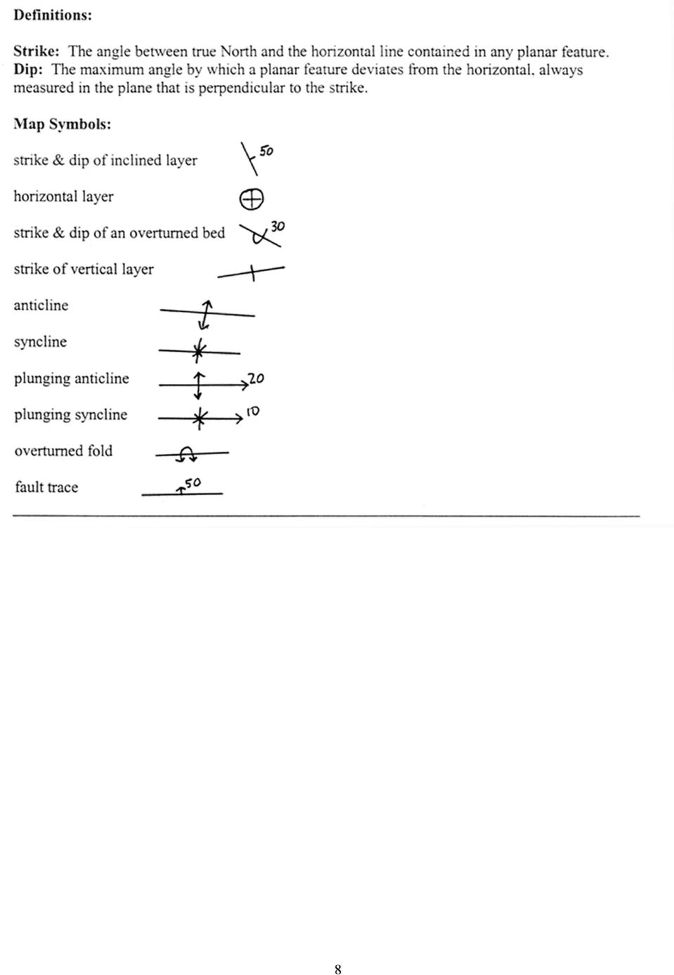
2 Part I Symbols for Strike and Dip (see Figs & 14.4, page 241, in your Lab Manual). 1) Using the symbols on the last 3 pages of this handout, and using your protractor/ruler, draw the appropriate symbols for the following attitudes (see Pages 8 & 9 of this lab). Assume NORTH is at the top of the page (6 points). A. Strike: NW, Dip: NE B. Strike: NE, Dip: SE C. Horizontal bedding D. Strike: N, Dip: W (but overturned) E. Strike: NE, Dip: NW F. Strike: SW, Dip: vertical Part II Faults in Cross-Section and Map View (e.g., Fig , Page 246, in your Lab Manual). 1) For each of the following three cross-sections and one map view of faults: a) Draw arrows indicating how the blocks either side of the fault have moved (the arrows should be drawn next to the fault face). (4 points I point for each diagram) b) Indicate (if possible) the direction of dip of the fault plane (i.e., north, south, east, west). If you can t tell, say so! (4 points) c) Identify the type of fault the diagram represents (normal, reverse, right or left-lateral strike-slip). (4 points) 2
.")
3 Part III Folds and Faults in Block Diagrams (see Fig. 14.9, page 245, in your Lab Manual). 1) Label the block diagrams below, indicating whether they are synclines, anticlines, plunging synclines and plunging anticlines (1 point each). Then label which bed(s) is/are oldest and which is/are youngest as seen in each block diagram. (3 points each) Assume the beds are not over-turned. (16 points total). 3
 is/are oldest and which is/are youngest as seen in each block diagram.")
4 2) The following questions are also drawn from your lab manual. Complete the blank sides in the two block diagrams (5 pts each). See Figure 14.5 (page 242) of your Lab manual for an example. Also look at Figures 14.9 and 14.10, page 245, in your lab manual Use a protractor to measure the angles of beds and the fault where appropriate. Lowest numbers (i.e., 2) correspond to the oldest rocks. Answer the following questions: a) In Figure A, what geologic structure is shown? HINT: Draw in the axial plane on the upper surface before you start. (3 pts) (see Fig. 14.9, page 245 in your lab manual) b) What kind of fault is shown in Figure B, and what kind of geologic structure does the fault cross-cut? (see Fig , page 245, in your lab manual). Bed 7 is the youngest, bed 2 the oldest. NOTE THAT THE WAY TO REPRESENT THE DIP OF A FAULT IS SHOWN IN THIS DIAGRAM. (2 pts for the structure; 2 pts for the fault) 4
 b) What kind of fault is shown in Figure B, and what kind of geologic structure does the fault cross-cut? (see Fig. 14.10, page 245, in your lab manual).")
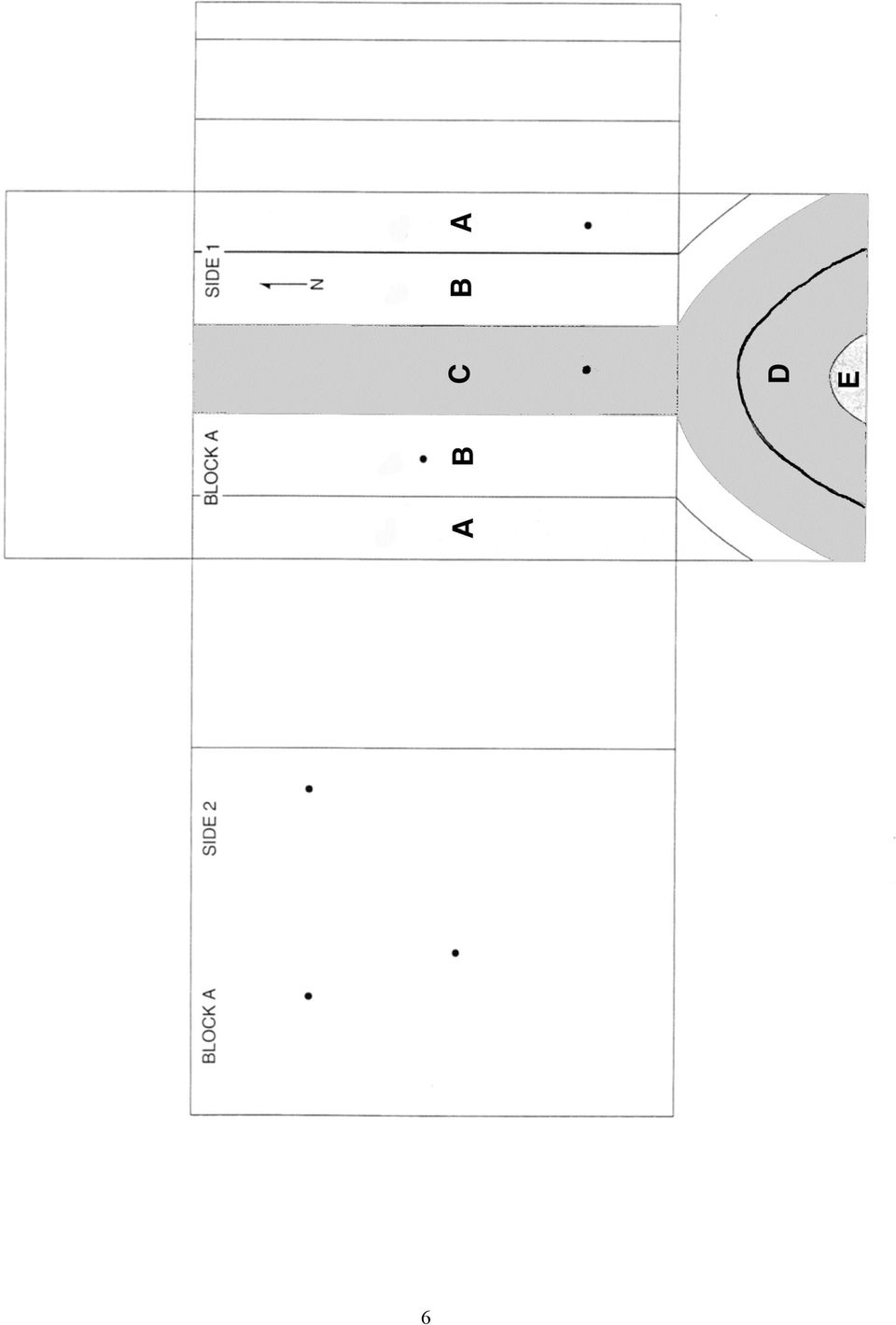
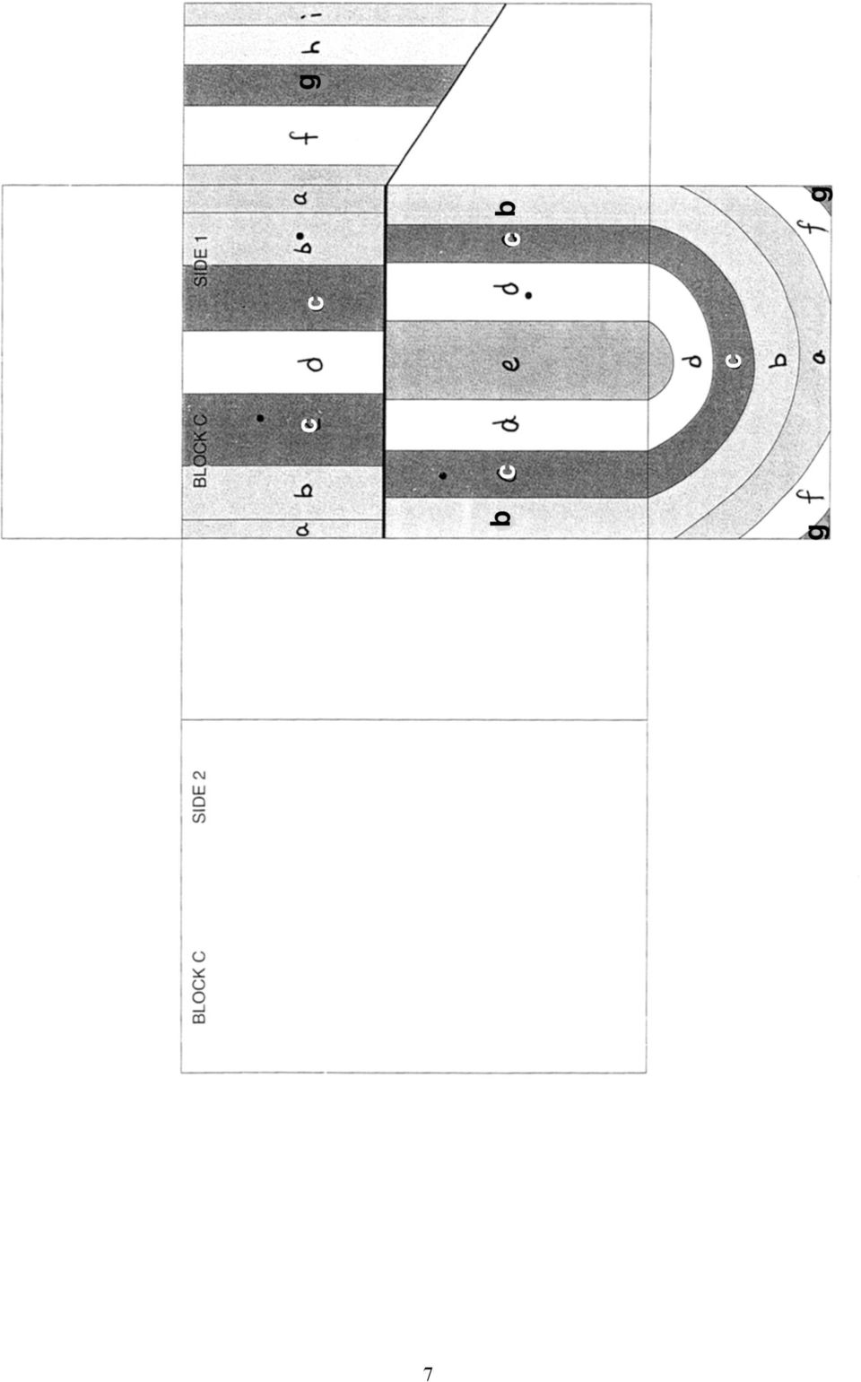
5 3) The following questions are drawn from your lab manual. The questions refer to the block diagrams on pages 6 and 7 of this handout. Cut out the diagrams before starting the problems. Assume no overturned beds. MAKE SURE YOUR NAME AND LAB DAY ARE CLEARLY WRITTEN ON THE BACK OF EACH BLOCK DIAGRAM. 3a) Refer to Block A with Side 1 up (26 pts Total) i) Fill in the blank faces on the sides and bottom (Side 2) of the block. In order to keep track of the layers I have labeled them as A, B, C, etc. Be sure to include these labels when filling in the blank faces. (10 pts.) ii) Put strike and dip symbols at the spaces indicated with dots on Sides 1 and 2. (6 pts) iii) Illustrate the position of the axial surface of the fold by sketching its trace on the top of the block. The trace is an imaginary line that outlines the axial surface. The axial surface most nearly divides a fold into two equal parts). (2 pts) iv) Label all oldest and youngest beds present on Sides 1 and 2 on the block. Make sure the T.A.s and I will be able to find your answers. (6 pts) v) What type of fold is this (as seen from Side 1)? Label the type of fold right on the block. Make sure the T.A.s and I will be able to find your answer. (2 pts) 3b) Refer to Block C with Side 1 up (32 pts Total). NOTE: The color block in your lab manual is incorrect. i) Fill in the blank faces on the sides and base of the block. Be sure to include these labels when filling in the blank faces. (20 pts) ii) Put strike and dip symbols at the spaces indicated with dots on Side 1. (4 pts) iii) Give a dip symbol with angle of dip for the fault on the block. (2 pts) iii) Indicate the relative movement of the fault by placing arrows on opposite sides of the fault on the side faces. (2 pts) iv) Label the hanging wall and footwall on the top and side faces right on the block. (4 pts) 5
 ii) Put strike and dip symbols at the spaces indicated with dots on Sides 1 and 2.")
6 6
7 7
8 8
9 9

10 10

Dip is the vertical angle perpendicular to strike between the imaginary horizontal plane and the inclined planar geological feature.
 Geological Visualization Tools and Structural Geology Geologists use several visualization tools to understand rock outcrop relationships, regional patterns and subsurface geology in 3D and 4D. Geological
Structural Geology Laboratory 9 (Name)
") Structural Geology Laboratory 9 (Name) Geologic maps show the distribution of different types of structures and rock stratigraphic units generally on a topographic base such as a quadrangle map. Key structures
Structural Geology Laboratory 9 (Name) Geologic maps show the distribution of different types of structures and rock stratigraphic units generally on a topographic base such as a quadrangle map. Key structures
LABORATORY TWO GEOLOGIC STRUCTURES
 EARTH AND ENVIRONMENT THROUGH TIME LABORATORY- EES 1005 LABORATORY TWO GEOLOGIC STRUCTURES Introduction Structural geology is the study of the ways in which rocks or sediments are arranged and deformed
Location and Distance on Earth (Chapter 22 part 1)
") GEOLOGY 306 Laboratory Instructor: TERRY J. BOROUGHS NAME: Location and Distance on Earth (Chapter 22 part 1) For this assignment you will require: a calculator, protractor, and a metric ruler, and an
GEOLOGY 306 Laboratory Instructor: TERRY J. BOROUGHS NAME: Location and Distance on Earth (Chapter 22 part 1) For this assignment you will require: a calculator, protractor, and a metric ruler, and an
GEOLOGIC MAPS. PURPOSE: To be able to understand, visualize, and analyze geologic maps
 GEOLOGIC MAPS PURPOSE: To be able to understand, visualize, and analyze geologic maps Geologic maps show the distribution of the various igneous, sedimentary, and metamorphic rocks at Earth s surface in
USING RELATIVE DATING AND UNCONFORMITIES TO DETERMINE SEQUENCES OF EVENTS
 EARTH AND ENVIRONMENT THROUGH TIME LABORATORY- EES 1005 LABORATORY THREE USING RELATIVE DATING AND UNCONFORMITIES TO DETERMINE SEQUENCES OF EVENTS Introduction In order to interpret Earth history from
Map Patterns and Finding the Strike and Dip from a Mapped Outcrop of a Planar Surface
 Map Patterns and Finding the Strike and Dip from a Mapped Outcrop of a Planar Surface Topographic maps represent the complex curves of earth s surface with contour lines that represent the intersection
STRUCTURAL GEOLOGY LABORATORY MANUAL
 STRUCTURAL GEOLOGY LABORATORY MANUAL Fourth Edition by David T. Allison Copyright 2015 Associate Professor of Geology Department of Earth Sciences University of South Alabama TABLE OF CONTENTS LABORATORY
Geology and Landscapes 2014 Maps and cross-sections
 Geology and Landscapes 2014 Maps and cross-sections Practicals 2 to 9 will be dedicated to the study of geological maps and the production of geological cross-section. Below is a summary of the different
Introduction to Structural Geology
 Introduction to Structural Geology Workbook 3 Geological Maps BGS Introduction to geological maps 4 1. Outcrop patterns on geological maps 7 2. Cross sections 16 3. Structure contours 22 cknowledgements
Geological Maps 1: Horizontal and Inclined Strata
 Geological Maps 1: Horizontal and Inclined Strata A well-rounded geologist must be familiar with the processes that shape the Earth as well as the rocks and minerals that comprise it. These processes cover
Unit 6 Direction and angle
 Unit 6 Direction and angle Three daily lessons Year 4 Spring term Unit Objectives Year 4 Recognise positions and directions: e.g. describe and find the Page 108 position of a point on a grid of squares
Experiment 5: Magnetic Fields of a Bar Magnet and of the Earth
 MASSACHUSETTS INSTITUTE OF TECHNOLOGY Department of Physics 8.02 Spring 2005 Experiment 5: Magnetic Fields of a Bar Magnet and of the Earth OBJECTIVES 1. To examine the magnetic field associated with a
Questions & Answers Proposed for Exam #3
 Questions & Answers Proposed for Exam #3 GE50 Introduction to Physical Geology (Geology for Engineers) Missouri University of Science and Technology Fall Semester 2007, Leslie Gertsch ([email protected])
Geological Maps 3: Faulted Strata
 Geological Maps 3: Faulted Strata Brittle deformation in rocks is characterized by fractures, joints and faults. Fractures and joints can be of any size, orientation or pattern. Some joints form regular
89.215 - FORENSIC GEOLOGY GEOLOGIC TIME AND GEOLOGIC MAPS
 NAME 89.215 - FORENSIC GEOLOGY GEOLOGIC TIME AND GEOLOGIC MAPS I. Introduction There are two types of geologic time, relative and absolute. In the case of relative time geologic events are arranged in
Plate Tectonics: Ridges, Transform Faults and Subduction Zones
 Plate Tectonics: Ridges, Transform Faults and Subduction Zones Goals of this exercise: 1. review the major physiographic features of the ocean basins 2. investigate the creation of oceanic crust at mid-ocean
Stability Assessment of Chamshir Dam Based on DEM, South West Zagros
 2015 2nd International Conference on Geological and Civil Engineering IPCBEE vol. 80 (2015) (2015) IACSIT Press, Singapore DOI: 10.7763/IPCBEE. 2015. V80. 13 Stability Assessment of Chamshir Dam Based
STRUCTURAL GEOLOGY LABORATORY MANUAL
 STRUCTURAL GEOLOGY LABORATORY MANUAL Fourth Edition by David T. Allison Copyright 2013 Associate Professor of Geology Department of Earth Sciences University of South Alabama TABLE OF CONTENTS LABORATORY
Yasuhiro Yamada a, *, Ken McClay b
 Journal of Structural Geology 25 (2003) 1331 1336 www.elsevier.com/locate/jsg Application of geometric models to inverted listric fault systems in sandbox experiments. Paper 2: insights for possible along
12.510 Introduction to Seismology Spring 2008
 MIT OpenCourseWare http://ocw.mit.edu 12.510 Introduction to Seismology Spring 2008 For information about citing these materials or our Terms of Use, visit: http://ocw.mit.edu/terms. 04/30/2008 Today s
Layers of the Earth and Plate Tectonics
 Layers of the Earth and Plate Tectonics Objectives: explain various ways the earth can be changed by natural forces define the term Geology define the terms Crust, Mantle, Outer Core and Inner Core classify
SECOND GRADE 1 WEEK LESSON PLANS AND ACTIVITIES
 SECOND GRADE 1 WEEK LESSON PLANS AND ACTIVITIES UNIVERSE CYCLE OVERVIEW OF SECOND GRADE UNIVERSE WEEK 1. PRE: Discovering stars. LAB: Analyzing the geometric pattern of constellations. POST: Exploring
Stratigraphic Cross Sections Why study old rocks?
 rom IRIS collection: Animations of eologic Processes www.iris.edu/educate/animations Stratigraphic ross Sections Why study old rocks? The earthquake potential of an area can be determined by studying the
Drilling into Science: A Hands-on Cooperative Learning Oil Exploration Activity designed for Middle School and High School Students
 Drilling into Science: A Hands-on Cooperative Learning Oil Exploration Activity designed for Middle School and High School Students Lauren C. Neitzke 1, Teresa Rousseau 2, and Diane Gavin 2 1. Rutgers
Geology 2 Physical Geology Lab Lab #9 Point Lobos Fieldtrip - Preparation
 Geology 2 Physical Geology Lab Fieldtrip - Preparation What: We will be going to Point Lobos State Reserve for our Wednesday October 18 class lecture and lab session Why: We will look at some of our local
SECOND GRADE PLATE TECTONICS 1 WEEK LESSON PLANS AND ACTIVITIES
 SECOND GRADE PLATE TECTONICS 1 WEEK LESSON PLANS AND ACTIVITIES PLATE TECTONIC CYCLE OVERVIEW OF SECOND GRADE VOLCANOES WEEK 1. PRE: Investigating the parts of a volcano. LAB: Comparing the parts of a
SGS4.3 Stage 4 Space & Geometry Part A Activity 2-4
 SGS4.3 Stage 4 Space & Geometry Part A Activity 2-4 Exploring triangles Resources required: Each pair students will need: 1 container (eg. a rectangular plastic takeaway container) 5 long pipe cleaners
Structural Axial, Shear and Bending Moments
 Structural Axial, Shear and Bending Moments Positive Internal Forces Acting Recall from mechanics of materials that the internal forces P (generic axial), V (shear) and M (moment) represent resultants
LAB 6: GRAVITATIONAL AND PASSIVE FORCES
 55 Name Date Partners LAB 6: GRAVITATIONAL AND PASSIVE FORCES And thus Nature will be very conformable to herself and very simple, performing all the great Motions of the heavenly Bodies by the attraction
Solving Simultaneous Equations and Matrices
 Solving Simultaneous Equations and Matrices The following represents a systematic investigation for the steps used to solve two simultaneous linear equations in two unknowns. The motivation for considering
ORANGE PUBLIC SCHOOLS OFFICE OF CURRICULUM AND INSTRUCTION OFFICE OF SCIENCE. GRADE 6 SCIENCE Post - Assessment
 ORANGE PUBLIC SCHOOLS OFFICE OF CURRICULUM AND INSTRUCTION OFFICE OF SCIENCE GRADE 6 SCIENCE Post - Assessment School Year 2013-2014 Directions for Grade 6 Post-Assessment The Grade 6 Post-Assessment is
A Guide to Writing a Geological Map Report in ESS241
 A Guide to Writing a Geological Map Report in ESS241 Allison Enright and Charly Bank Department of Earth Sciences University of Toronto Abstract Your abstract should be a stand-alone summary of your report,
Rock Cycle Part I Student Guide
 Rock Cycle Part I Student Guide Write your answers on the separate answer sheet provided. Introduction Why are there different kinds of rock on Earth? Earth rocks are recycled so that new rock is constantly
THE TRANSITION FROM OPEN PIT TO UNDERGROUND MINING: AN UNUSUAL SLOPE FAILURE MECHANISM AT PALABORA
 THE TRANSITION FROM OPEN PIT TO UNDERGROUND MINING: AN UNUSUAL SLOPE FAILURE MECHANISM AT PALABORA Richard K. Brummer*, Hao Li* & Allan Moss *Itasca Consulting Canada Inc., Rio Tinto Limited ABSTRACT At
LAB 6 - GRAVITATIONAL AND PASSIVE FORCES
 L06-1 Name Date Partners LAB 6 - GRAVITATIONAL AND PASSIVE FORCES OBJECTIVES And thus Nature will be very conformable to herself and very simple, performing all the great Motions of the heavenly Bodies
Geologic History Review
 1. The climate that existed in an area during the early Paleozoic Era can best be determined by studying (1) the present climate of the area (2) recorded climate data of the area since 1700 (3) present
Lesson 3: The Big Rock Lesson: Introduction to Rocks. Scientific Process(es) Addressed: Observing, communicating, inferring and defining operationally
 Addressed: Observing, communicating, inferring and defining operationally") Target Grade or Age Level: Sixth grade earth science Lesson 3: The Big Rock Lesson: Introduction to Rocks Scientific Process(es) Addressed: Observing, communicating, inferring and defining operationally
Target Grade or Age Level: Sixth grade earth science Lesson 3: The Big Rock Lesson: Introduction to Rocks Scientific Process(es) Addressed: Observing, communicating, inferring and defining operationally
Pore pressure. Ordinary space
 Fault Mechanics Laboratory Pore pressure scale Lowers normal stress, moves stress circle to left Doesn Doesn t change shear Deviatoric stress not affected This example: failure will be by tensile cracks
Geologic Time. Relative Dating. Principle of Original Horizontality. Relative Time. Absolute Time. Geologic Column
 Geologic Time Relative Time 5 Principles of Relative Dating Absolute Time Radiometric Dating Geologic Column Relative Dating principle of horizontality principle of superposition principle of cross-cutting
Suggested Activities Processes that Shape the Earth: Earth s Structure and Plate Tectonics
 Suggested Activities Processes that Shape the Earth: Earth s Structure and Plate Tectonics From Harcourt Science Teacher Ed. Source (Grade Level) Title Pages Concept Harcourt Science (4) The Layers of
Lesson #13 Congruence, Symmetry and Transformations: Translations, Reflections, and Rotations
 Math Buddies -Grade 4 13-1 Lesson #13 Congruence, Symmetry and Transformations: Translations, Reflections, and Rotations Goal: Identify congruent and noncongruent figures Recognize the congruence of plane
Locating the Epicenter and Determining the Magnitude of an Earthquake
 Locating the and Determining the Magnitude of an Earthquake Locating the Measuring the S-P time interval There are hundreds of seismic data recording stations throughout the United States and the rest
1. You are about to begin a unit on geology. Can anyone tell me what geology is? The study of the physical earth I.
 PLATE TECTONICS ACTIVITY The purpose of this lab is to introduce the concept of plate tectonics and the formation of mountains. Students will discuss the properties of the earth s crust and plate tectonics.
Line Segments, Rays, and Lines
 HOME LINK Line Segments, Rays, and Lines Family Note Help your child match each name below with the correct drawing of a line, ray, or line segment. Then observe as your child uses a straightedge to draw
Geometry 1. Unit 3: Perpendicular and Parallel Lines
 Geometry 1 Unit 3: Perpendicular and Parallel Lines Geometry 1 Unit 3 3.1 Lines and Angles Lines and Angles Parallel Lines Parallel lines are lines that are coplanar and do not intersect. Some examples
Printing Letters Correctly
 Printing Letters Correctly The ball and stick method of teaching beginners to print has been proven to be the best. Letters formed this way are easier for small children to print, and this print is similar
Activity 3: Observing the Moon
 Activity 3: Observing the Moon Print Name: Signature: 1.) KEY. 2.). 3.). 4.). Activity: Since the dawn of time, our closest neighbor the moon has fascinated humans. In this activity we will explore the
Reflection and Refraction
 Equipment Reflection and Refraction Acrylic block set, plane-concave-convex universal mirror, cork board, cork board stand, pins, flashlight, protractor, ruler, mirror worksheet, rectangular block worksheet,
Plate Tectonics Web-Quest
 Plate Tectonics Web-Quest Part I: Earth s Structure. Use the following link to find these answers: http://www.learner.org/interactives/dynamicearth/structure.html 1. Label the layers of Earth in the diagram
GETTING TO THE CORE: THE LINK BETWEEN TEMPERATURE AND CARBON DIOXIDE
 DESCRIPTION This lesson plan gives students first-hand experience in analyzing the link between atmospheric temperatures and carbon dioxide ( ) s by looking at ice core data spanning hundreds of thousands
E XPLORING QUADRILATERALS
 E XPLORING QUADRILATERALS E 1 Geometry State Goal 9: Use geometric methods to analyze, categorize and draw conclusions about points, lines, planes and space. Statement of Purpose: The activities in this
Mirror, mirror - Teacher Guide
 Introduction Mirror, mirror - Teacher Guide In this activity, test the Law of Reflection based on experimental evidence. However, the back-silvered glass mirrors present a twist. As light travels from
Laboratory 6: Topographic Maps
 Name: Laboratory 6: Topographic Maps Part 1: Construct a topographic map of the Egyptian Pyramid of Khafre A topographic map is a two-dimensional representation of a three-dimensional space. Topographic
Structural Origin of the Claremont Anticline, Nova Scotia: Has new seismic solved an old problem?
 Structural Origin of the Claremont Anticline, Nova Scotia: Has new seismic solved an old problem? J.P.(Paddy) Chesterman Devon Canada Corporation, 301 400-3rd Avenue SW, Calgary, AB, T2P 4H2 [email protected]
Earthquakes. Earthquakes: Big Ideas. Earthquakes
 Earthquakes Earthquakes: Big Ideas Humans cannot eliminate natural hazards but can engage in activities that reduce their impacts by identifying high-risk locations, improving construction methods, and
The Dynamic Crust 2) EVIDENCE FOR CRUSTAL MOVEMENT
 EVIDENCE FOR CRUSTAL MOVEMENT") The Dynamic Crust 1) Virtually everything you need to know about the interior of the earth can be found on page 10 of your reference tables. Take the time to become familiar with page 10 and everything
The Dynamic Crust 1) Virtually everything you need to know about the interior of the earth can be found on page 10 of your reference tables. Take the time to become familiar with page 10 and everything
MECHANICS OF SOLIDS - BEAMS TUTORIAL 2 SHEAR FORCE AND BENDING MOMENTS IN BEAMS
 MECHANICS OF SOLIDS - BEAMS TUTORIAL 2 SHEAR FORCE AND BENDING MOMENTS IN BEAMS This is the second tutorial on bending of beams. You should judge your progress by completing the self assessment exercises.
Scaffolding Task: Angle Tangle
 Fourth Grade Mathematics Unit Scaffolding Task: Angle Tangle STANDARDS FOR MATHEMATICAL CONTENT MCC4.MD.5. Recognize angles as geometric shapes that are formed wherever two rays share a common endpoint,
Paper Reference. Edexcel GCSE Mathematics (Linear) 1380 Paper 1 (Non-Calculator) Foundation Tier
 1380 Paper 1 (Non-Calculator) Foundation Tier") Centre No. Candidate No. Paper Reference 1 3 8 0 1 F Paper Reference(s) 1380/1F Edexcel GCSE Mathematics (Linear) 1380 Paper 1 (Non-Calculator) Foundation Tier Friday 2 March 2012 Afternoon Time: 1 hour
Centre No. Candidate No. Paper Reference 1 3 8 0 1 F Paper Reference(s) 1380/1F Edexcel GCSE Mathematics (Linear) 1380 Paper 1 (Non-Calculator) Foundation Tier Friday 2 March 2012 Afternoon Time: 1 hour
Name: Date: Class: Finding Epicenters and Measuring Magnitudes Worksheet
 Example Answers Name: Date: Class: Finding Epicenters and Measuring Magnitudes Worksheet Objective: To use seismic data and an interactive simulation to triangulate the location and measure the magnitude
Plate Tectonics. Introduction. Boundaries between crustal plates
 Plate Tectonics KEY WORDS: continental drift, seafloor spreading, plate tectonics, mid ocean ridge (MOR) system, spreading center, rise, divergent plate boundary, subduction zone, convergent plate boundary,
Lab 2: Vector Analysis
 Lab 2: Vector Analysis Objectives: to practice using graphical and analytical methods to add vectors in two dimensions Equipment: Meter stick Ruler Protractor Force table Ring Pulleys with attachments
PDCA Driven-Pile Terms and Definitions
 PDCA Driven-Pile Terms and Definitions This document is available for free download at piledrivers.org. Preferred terms are descriptively defined. Potentially synonymous (but not preferred) terms are identified
Cut out a design. Do not cut down the fold line.
 Symmetry esson 8 Fold a piece of paper in half. ut out a design. o not cut down the fold line. Unfold the cut out design. You have just made a symmetric figure. symmetric figure can be folded so that both
LESSON PLAN FOR ROCKS AND MINERALS. Episode Six 306 Street Science (Earth Science)
") LESSON PLAN FOR ROCKS AND MINERALS Episode Six 306 Street Science (Earth Science) Science lessons come easily if you are along a stream bed or road cut. All around you are examples of sedimentary rocks,
LESSON PLAN FOR ROCKS AND MINERALS Episode Six 306 Street Science (Earth Science) Science lessons come easily if you are along a stream bed or road cut. All around you are examples of sedimentary rocks,
3D Drawing. Single Point Perspective with Diminishing Spaces
 3D Drawing Single Point Perspective with Diminishing Spaces The following document helps describe the basic process for generating a 3D representation of a simple 2D plan. For this exercise we will be
Section 9.1 Vectors in Two Dimensions
 Section 9.1 Vectors in Two Dimensions Geometric Description of Vectors A vector in the plane is a line segment with an assigned direction. We sketch a vector as shown in the first Figure below with an
Carbonate Rock Formation
 Limestone, dolomite (or dolostone), and marble are often collectively referred to as carbonate rocks because the main mineral is calcite. The chemical name of calcite is calcium carbonate. Limestone, dolomite,
Missouri Regions Shaped by Land Forms and Geology
 Missouri Regions Shaped by Land Forms and Geology Lesson Abstract Summary: MO GLE: Subject Areas: The students will use various resources to compare and contrast the geology of each Missouri region to
Unit 4 Lesson 6 Measuring Earthquake Waves. Copyright Houghton Mifflin Harcourt Publishing Company
 Shake, Rattle, and Roll What happens during an earthquake? As plates of the lithosphere move, the stress on rocks at or near the edges of the plates increases. This stress causes faults to form. A fault
Procedure: Geometrical Optics. Theory Refer to your Lab Manual, pages 291 294. Equipment Needed
 Theory Refer to your Lab Manual, pages 291 294. Geometrical Optics Equipment Needed Light Source Ray Table and Base Three-surface Mirror Convex Lens Ruler Optics Bench Cylindrical Lens Concave Lens Rhombus
Difference between a vector and a scalar quantity. N or 90 o. S or 270 o
 Vectors Vectors and Scalars Distinguish between vector and scalar quantities, and give examples of each. method. A vector is represented in print by a bold italicized symbol, for example, F. A vector has
CHAPTER 6 THE TERRESTRIAL PLANETS
 CHAPTER 6 THE TERRESTRIAL PLANETS MULTIPLE CHOICE 1. Which of the following is NOT one of the four stages in the development of a terrestrial planet? 2. That Earth, evidence that Earth differentiated.
Magnetic Fields and Their Effects
 Name Date Time to Complete h m Partner Course/ Section / Grade Magnetic Fields and Their Effects This experiment is intended to give you some hands-on experience with the effects of, and in some cases
Part 1: Background - Graphing
 Department of Physics and Geology Graphing Astronomy 1401 Equipment Needed Qty Computer with Data Studio Software 1 1.1 Graphing Part 1: Background - Graphing In science it is very important to find and
The following questions refer to Chapter 19, (PAGES 259 278 IN YOUR MANUAL, 7 th ed.)
") GEOLOGY 306 Laboratory Instructor: TERRY J. BOROUGHS NAME: Locating the Planets (Chapter 19) and the Moon and Sun (Chapter 21) For this assignment you will require: a calculator, colored pencils, a metric
GEOLOGY 306 Laboratory Instructor: TERRY J. BOROUGHS NAME: Locating the Planets (Chapter 19) and the Moon and Sun (Chapter 21) For this assignment you will require: a calculator, colored pencils, a metric
Geologic time and dating. Geologic time refers to the ages relevant to Earth s history
 Geologic time and dating Most figures and tables contained here are from course text: Understanding Earth Fourth Edition by Frank Press, Raymond Siever, John Grotzinger, and Thomas H. Jordan Geologic time
Exploration of the Solar System
 Exploration of the Solar System I. Phases of the Moon all about perspective. In this section you will use WWT to explore how the moon appears to change phases from our vantage point on Earth over the course
What is Energy? 1 45 minutes Energy and You: Energy Picnic Science, Physical Education Engage
 Unit Grades K-3 Awareness Teacher Overview What is energy? Energy makes change; it does things for us. It moves cars along the road and boats over the water. It bakes a cake in the oven and keeps ice frozen
FOURTH GRADE PLATE TECTONICS 1 WEEK LESSON PLANS AND ACTIVITIES
 FOURTH GRADE PLATE TECTONICS 1 WEEK LESSON PLANS AND ACTIVITIES PLATE TECTONIC CYCLE OVERVIEW OF FOURTH GRADE VOLCANOES WEEK 1. PRE: Comparing different structures of volcanoes. LAB: Modeling three types
Unit: Restless Earth Lesson: Earth s Interior
 Melissa Duran, Hoover Middle School, San Jose, CA 1/9/03 Bay Area Science Museum Collaboratory Project Unit: Restless Earth Lesson: Earth s Interior Introduction Standards: 1.b, 7.e Objectives Students
BASIC LESSON Objective(s)
") [Geology - Landforms] [K-1: Basic] [Grades 2-3: Advanced] BACKGROUND Landforms are natural features of the Earth's surface. They are created by the movement of ice or water, earthquakes, lava flows, volcanoes,
[Geology - Landforms] [K-1: Basic] [Grades 2-3: Advanced] BACKGROUND Landforms are natural features of the Earth's surface. They are created by the movement of ice or water, earthquakes, lava flows, volcanoes,
EARTHQUAKES. Compressional Tensional Slip-strike
 Earthquakes-page 1 EARTHQUAKES Earthquakes occur along faults, planes of weakness in the crustal rocks. Although earthquakes can occur anywhere, they are most likely along crustal plate boundaries, such
FIRST GRADE PLATE TECTONICS 1 WEEK LESSON PLANS AND ACTIVITIES
 FIRST GRADE PLATE TECTONICS 1 WEEK LESSON PLANS AND ACTIVITIES PLATE TECTONIC CYCLE OVERVIEW OF FIRST GRADE VOLCANOES WEEK 1. PRE: Learning the shapes of volcanoes. LAB: Experimenting with "lava." POST:
Using Google Earth to Explore Plate Tectonics
 Using Google Earth to Explore Plate Tectonics Laurel Goodell, Department of Geosciences, Princeton University, Princeton, NJ 08544 [email protected] Inspired by, and borrows from, the GIS-based Exploring
Experiment 3: Magnetic Fields of a Bar Magnet and Helmholtz Coil
 MASSACHUSETTS INSTITUTE OF TECHNOLOGY Department of Physics 8.02 Spring 2006 Experiment 3: Magnetic Fields of a Bar Magnet and Helmholtz Coil OBJECTIVES 1. To learn how to visualize magnetic field lines
What You ll Learn. Why It s Important
 These students are setting up a tent. How do the students know how to set up the tent? How is the shape of the tent created? How could students find the amount of material needed to make the tent? Why
Earthquakes, faulting, beach-balls, magnitude scales
 Earthquakes, faulting, beach-balls, magnitude scales Faulting Geometry Faulting is a complex process and the variety of faults that exists is large. We will consider a simplified but general fault classification
1 of 79 Erik Eberhardt UBC Geological Engineering EOSC 433
 Stress & Strain: A review xx yz zz zx zy xy xz yx yy xx yy zz 1 of 79 Erik Eberhardt UBC Geological Engineering EOSC 433 Disclaimer before beginning your problem assignment: Pick up and compare any set
Friday 18 January 2013 Morning
 Friday 18 January 2013 Morning AS GCE PHYSICS B (ADVANCING PHYSICS) G492/01 Understanding Processes / Experimentation and Data Handling *G411640113* Candidates answer on the Question Paper. OCR supplied
FIFTH GRADE PLATE TECTONICS 1 WEEK LESSON PLANS AND ACTIVITIES
 FIFTH GRADE PLATE TECTONICS 1 WEEK LESSON PLANS AND ACTIVITIES PLATE TECTONIC CYCLE OVERVIEW OF FIFTH GRADE VOLCANOES WEEK 1. PRE: Exploring the rocks produced by volcanoes. LAB: Comparing igneous rocks.
QUATERNARY DATING METHODS 1: RELATIVE DATING TECHNIQUES
 QUATERNARY DATING METHODS 1: RELATIVE DATING TECHNIQUES Objectives: In this lab we will examine relative dating methods used to date Quaternary glacial deposits. After this lab you should be able to: 1)
Exploring the Phases of the Moon
 Exploring the Phases of the Moon Activity UCIObs 5 Grade Level: 3 5 Source: Copyright (2009) by Tammy Smecker-Hane. Contact [email protected] with questions. Standards: This activity addresses these California
Plate Tectonics: Big Ideas. Plate Tectonics. Plate Tectonics. The unifying concept of the Earth sciences.
 Plate Tectonics: Big Ideas Our understanding of Earth is continuously refined. Earth s systems are dynamic; they continually react to changing influences from geological, hydrological, physical, chemical,
Chapter 7 Earthquake Hazards Practice Exam and Study Guide
 Chapter 7 Earthquake Hazards Practice Exam and Study Guide 1. Select from the following list, all of the factors that affect the intensity of ground shaking. a. The magnitude of the earthquake b. Rather
Experiment 3: Magnetic Fields of a Bar Magnet and Helmholtz Coil
 MASSACHUSETTS INSTITUTE OF TECHNOLOGY Department of Physics 8.02 Spring 2009 Experiment 3: Magnetic Fields of a Bar Magnet and Helmholtz Coil OBJECTIVES 1. To learn how to visualize magnetic field lines
Unit 8 Angles, 2D and 3D shapes, perimeter and area
 Unit 8 Angles, 2D and 3D shapes, perimeter and area Five daily lessons Year 6 Spring term Recognise and estimate angles. Use a protractor to measure and draw acute and obtuse angles to Page 111 the nearest
1 Branches of Earth Science
 CHAPTER 1 1 Branches of Earth Science SECTION The World of Earth Science BEFORE YOU READ After you read this section, you should be able to answer these questions: What are the four major branches of Earth