Using Remotely Sensed Data From ASTER to Look Impact of Recent Earth Quakes in Gujarat, India.
|
|
|
- Doris Sherman
- 8 years ago
- Views:
Transcription
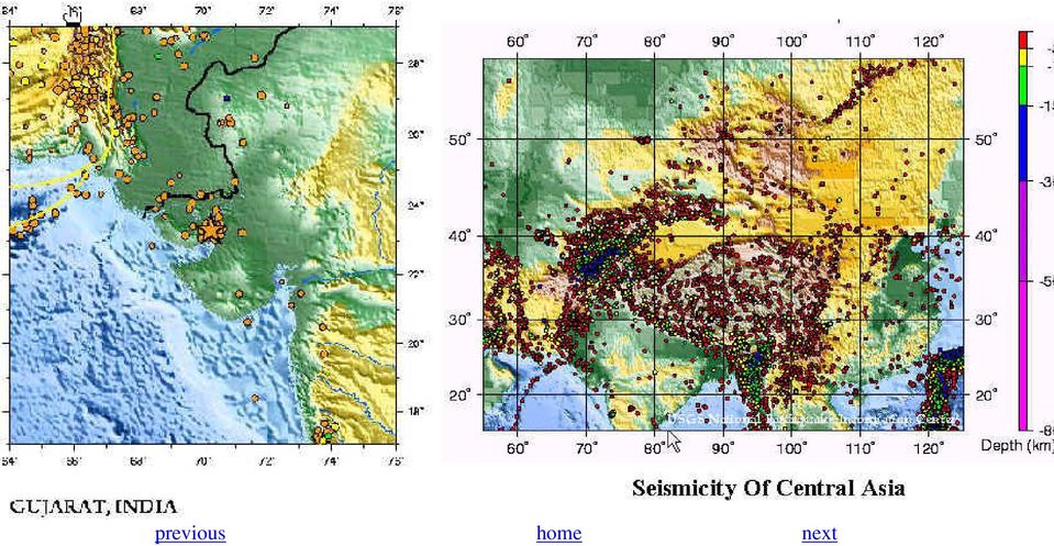
1 Using Remotely Sensed Data From ASTER to Look Impact of Recent Earth Quakes in Gujarat, India. A major earth quake occurred in Gujarat, India on January 26,2000. (Origin time 03:16 GMT, Location N E Magnitude 7.6 on Richter scale, depth 17 km). Earthquake was caused by rupture of fault with in the Indian plate. These kind of earth quakes are called intra-plate earthquake. it caused two geologically significant phenomenon 1) liquefaction 2) fault rupture. The study was conducted to look at these phenomenon by using ASTER images (Advanced Spaceborne Thermal Emission and Reflection Radiometer). For this study two images were used (one from before the earth quake and one from after the earth quake). The study was divided in to two parts, one was to look at the change in hydrology (phenomena of liquefaction) to detect this change, 13th band (thermal band, which showed highest digital number values, the change in values in thermal band was interpreted as change n soil moisture) and visual inspection was also used this as the change was visually perceivable (for this 1st, 2nd and 3rd of visual and near infra red, (VNIR) bands were used). second part of the study was to look at look at faults using satellite image. images from ASTER could not be used to detect fault rupture because of low resolution, images of high resolution of 1 m or less have to be used for this. NEXT Introduction
.")
2 A Mw 7.7 earthquake struck the Kachchh region of Gujarat state in western India at 8:46 a.m. (local time) on January 26, this was the most damaging earthquake in the last fifty years in India. over 20,000 persons were reported dead and over 167,000 injured. the estimated economic loss due to this quake is placed at around US$5 billion. the earthquake was felt in most parts of the country, strongly by people in multi-story buildings in Bombay (~570 km ), and as far away as Calcutta, 1900 km to the east. the entire Kachchh region of Gujarat was extensively damaged, several towns and large villages like Bhuj, Anjar, Vondh, and Bhachau, sustained widespread destruction. Earthquake was caused by rupture of fault with in the Indian plate. These kind of earth quakes are called intra-plate earthquake. during this earthquake two geologically significant phenomenon's were noticed: Liquefaction. Fault rupture. The study concentrates on looking at these phenomenon using ASTER images. previous home next Tectonic Setting The tectonic setting of the Kachchh region is not well understood. It has been classified as stable continental region (SCR), but its proximity to active inter-plate faults suggests it may be transitional between SCR and the plate boundary. The January 26 th earthquake appears to have occurred at depth beneath the eastern Kachchh mainland fault. A series of anticlines occurs along the mainland fault for over 220 km. This fold belt may have uplifted quaternary fluvial terraces on its north flank and formed anticlinal structures and domes in quaternary sediments that underlie the salt flats in the eastern Little-Rann near 23-17N, 71-14E. location and setting of the earthquake.

3 Geological and Geotechnical Effects Fault rupture: No primary fault rupture or sharp folding was reported. But a zone of ground deformation occurred with in alluvial deposits near the northern margin of an anticline and the main land fault. Which caused extensional ground cracking and compressional bulging in a zone over 16 km ling and 0.5 km wide near the epicenter, and these are attributed to liquefaction and lateral spreading. Liquefaction: The earth quake produced wide spread liquefaction in the Great Rann, Little Rann, Banni plains, Kandla river and gulf of Kachch. Liquefaction was manifest at the surface as sand boils, lateral spreads, and collapse features.[1] Topographic relief map showing MSK intensity levels and general distribution of liquefaction Seismic History of Area of Interest

4 previous home next
5 Aster is a multispectral scanner that produces that produces images of high spatial resolution. It is flying in earth orbit, on terra, the first platform of NASA s Earth Observation System. The instrument has three bands in the visible and near-infrared (VNIR)spectral range( mm) with 15-m spatial resolution, six bands in the short-wave-infra-red (SWIR) spectral range ( mm) with 30 m resolution, and five bands in the thermalinfrared (TIR) spectral range.(8-12 mm), with 90 m resolution. These 14 bands are collected in three down looking telescope. Another back word viewing telescope with a single band duplication (VNIR) band 3 provide the capability for stereogrammetric data.[2] The ASTER Imaging System previous home next Methodology Images used: Two ASTER images of the study area were used in the study. One image before the earth quake and a image after
 band 3 provide the capability for stereogrammetric data.")
6 earth quake. To felicitate change detection. Image Processing: PCI (image processing software) was used to extracted images from there HDF compressed form. Bands 1,2, and 3 and 13th band ( in TIR) were imported into PCI independently because of there different resolutions. After impor images, 13th band, thermal images were exported to ERDAS using ENVI, as image calculations are easy and simp previous home next Images Used in Analysis

7 previous home next

8 Change in Hydrology Change Detection Using Visual Inspection: Change Detection Using Thermal Band:

9 previous home next Faults
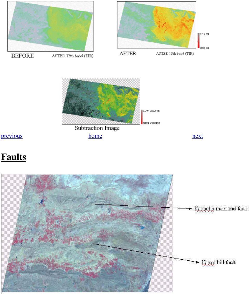
10 visual identification of faults previous home next Conclusions References: The present study looked at changes in hydrology and tried to look at active faults using ASTER images. This study can be extended to look for rupture of faults during earth quake. This can be done by creating high precision DEMs and subtracting their height values. But this needs very high resolution images (may be 1m or less). 1) Preliminary Observation on the Origin and Effects of the January 26, 2001 Bhuj (Gujarat, India) Earthquake. EERI Special Earthquake Report - April ) Gillespie, A.R., Rokguwa, S., Hook, S.J., Matsunaga, T., Temperature Emissivity Separation Algorithm Theoretical Basis Document, Version2.4. Jet Propulsion Laboratory, Pasadena, 22, March ) 4) previous home stop
 Gillespie, A.R., Rokguwa, S., Hook, S.J., Matsunaga, T., Temperature Emissivity Separation Algorithm Theoretical Basis Document, Version2.4.")
APPLICATION OF TERRA/ASTER DATA ON AGRICULTURE LAND MAPPING. Genya SAITO*, Naoki ISHITSUKA*, Yoneharu MATANO**, and Masatane KATO***
 APPLICATION OF TERRA/ASTER DATA ON AGRICULTURE LAND MAPPING Genya SAITO*, Naoki ISHITSUKA*, Yoneharu MATANO**, and Masatane KATO*** *National Institute for Agro-Environmental Sciences 3-1-3 Kannondai Tsukuba
Automated Spacecraft Scheduling The ASTER Example
 Automated Spacecraft Scheduling The ASTER Example Ron Cohen ronald.h.cohen@jpl.nasa.gov Ground System Architectures Workshop 2002 Jet Propulsion Laboratory The Concept Scheduling by software instead of
High Resolution Information from Seven Years of ASTER Data
 High Resolution Information from Seven Years of ASTER Data Anna Colvin Michigan Technological University Department of Geological and Mining Engineering and Sciences Outline Part I ASTER mission Terra
Earthquakes. Earthquakes: Big Ideas. Earthquakes
 Earthquakes Earthquakes: Big Ideas Humans cannot eliminate natural hazards but can engage in activities that reduce their impacts by identifying high-risk locations, improving construction methods, and
3D VISUALIZATION OF GEOTHERMAL WELLS DIRECTIONAL SURVEYS AND INTEGRATION WITH DIGITAL ELEVATION MODEL (DEM)
") Presented at Short Course VII on Exploration for Geothermal Resources, organized by UNU-GTP, GDC and KenGen, at Lake Bogoria and Lake Naivasha, Kenya, Oct. 27 Nov. 18, 2012. GEOTHERMAL TRAINING PROGRAMME
Presented at Short Course VII on Exploration for Geothermal Resources, organized by UNU-GTP, GDC and KenGen, at Lake Bogoria and Lake Naivasha, Kenya, Oct. 27 Nov. 18, 2012. GEOTHERMAL TRAINING PROGRAMME
PACIFIC TSUNAMI: CONTINUING RESEARCH AND FORMATION OF A MUSEUM EXHIBIT
 PACIFIC TSUNAMI: CONTINUING RESEARCH AND FORMATION OF A MUSEUM EXHIBIT Melissa Ann Meiner Geology/Marine Science Department University of Hawai i at Hilo Hilo, HI 96720 ABSTRACT The Sumatran tsunami was
Magnitude 7.2 GUERRERO, MEXICO
 A powerful magnitude-7.2 earthquake shook central and southern Mexico on Friday. The earthquake occurred at a depth of 24 km (15 miles). Its epicenter was in the western state of Guerrero, near the seaside
Earthquake Hazards and Risks
 Page 1 of 7 EENS 3050 Tulane University Natural Disasters Prof. Stephen A. Nelson Earthquake Hazards and Risks This page last updated on 28-Aug-2013 Earthquake Risk Many seismologists have said that "earthquakes
A remote sensing instrument collects information about an object or phenomenon within the
 Satellite Remote Sensing GE 4150- Natural Hazards Some slides taken from Ann Maclean: Introduction to Digital Image Processing Remote Sensing the art, science, and technology of obtaining reliable information
Chapter Overview. Bathymetry. Measuring Bathymetry. Echo Sounding Record. Measuring Bathymetry. CHAPTER 3 Marine Provinces
 Chapter Overview CHAPTER 3 Marine Provinces The study of bathymetry charts ocean depths and ocean floor topography. Echo sounding and satellites are efficient bathymetric tools. Most ocean floor features
ABSTRACT INTRODUCTION PURPOSE
 EVALUATION OF TSUNAMI DISASTER BY THE 2011 OFF THE PACIFIC COAST OF TOHOKU EARTHQUAKE IN JAPAN BY USING TIME SERIES SATELLITE IMAGES WITH MULTI RESOLUTION Hideki Hashiba Associate Professor Department
February 28 Earthquake: We got off easy
 February 28 Earthquake: We got off easy State Geologist John Beaulieu Lucky may not be the first word that comes to mind after an earthquake that injured more than 200 and caused more than $1 billion damage,
Assessment of Impact of the December 26, 2004 Tsunami In Aceh Province Indonesia
 Assessment of Impact of the December 26, 2004 Tsunami In Aceh Province Indonesia Jay H. Samek, David L. Skole, and Walter Chomentowski December 30, 2004 Center for Global Change and Earth Observations
Magnitude 8.8 OFFSHORE MAULE, CHILE
 A great 8.8-magnitude struck central Chile early Saturday. The quake hit 200 miles (325 kilometers) southwest of the capital Santiago. The epicenter was just 70 miles (115 kilometers) from Concepcion,
Land Use/Land Cover Map of the Central Facility of ARM in the Southern Great Plains Site Using DOE s Multi-Spectral Thermal Imager Satellite Images
 Land Use/Land Cover Map of the Central Facility of ARM in the Southern Great Plains Site Using DOE s Multi-Spectral Thermal Imager Satellite Images S. E. Báez Cazull Pre-Service Teacher Program University
2.3 Spatial Resolution, Pixel Size, and Scale
 Section 2.3 Spatial Resolution, Pixel Size, and Scale Page 39 2.3 Spatial Resolution, Pixel Size, and Scale For some remote sensing instruments, the distance between the target being imaged and the platform,
4.6 GEOLOGIC AND SEISMIC HAZARDS
 4.6 GEOLOGIC AND SEISMIC HAZARDS This Section describes the current conditions relating to the geologic and seismic characteristics of the City of Cypress. This Section concludes with an analysis of geologic
Preliminary damage survey report on 2015 Nepal Gorkha Earthquake
 Tokyo, 13 May 2015 Preliminary damage survey report on 2015 Nepal Gorkha Earthquake Pokhrel R.M., Chiaro G., Kiyota T., Katagiri T. Institute of Industrial Science, University of Tokyo, Japan Goda K. Bristol
Software requirements * :
 Title: Product Type: Developer: Target audience: Format: Software requirements * : Data: Estimated time to complete: Fire Mapping using ASTER Part I: The ASTER instrument and fire damage assessment Part
Review for Introduction to Remote Sensing: Science Concepts and Technology
 Review for Introduction to Remote Sensing: Science Concepts and Technology Ann Johnson Associate Director ann@baremt.com Funded by National Science Foundation Advanced Technological Education program [DUE
Hyperspectral Satellite Imaging Planning a Mission
 Hyperspectral Satellite Imaging Planning a Mission Victor Gardner University of Maryland 2007 AIAA Region 1 Mid-Atlantic Student Conference National Institute of Aerospace, Langley, VA Outline Objective
METHODOLOGY FOR LANDSLIDE SUSCEPTIBILITY AND HAZARD MAPPING USING GIS AND SDI
 The 8th International Conference on Geo-information for Disaster Management Intelligent Systems for Crisis Management METHODOLOGY FOR LANDSLIDE SUSCEPTIBILITY AND HAZARD MAPPING USING GIS AND SDI T. Fernández
TECTONICS ASSESSMENT
 Tectonics Assessment / 1 TECTONICS ASSESSMENT 1. Movement along plate boundaries produces A. tides. B. fronts. C. hurricanes. D. earthquakes. 2. Which of the following is TRUE about the movement of continents?
Georgia Performance Standards Framework for Natural Disasters 6 th Grade
 The following instructional plan is part of a GaDOE collection of Unit Frameworks, Performance Tasks, examples of Student Work, and Teacher Commentary. Many more GaDOE approved instructional plans are
Development of Guidance Information for the Repair and Rebuilding of Houses Following the Canterbury Earthquake Series
 Development of Guidance Information for the Repair and Rebuilding of Houses Following the Canterbury Earthquake Series Graeme J Beattie (1) 1. Principal Structural Engineer, BRANZ Ltd, Private Bag 50908,
The Dynamic Crust 2) EVIDENCE FOR CRUSTAL MOVEMENT
 EVIDENCE FOR CRUSTAL MOVEMENT") The Dynamic Crust 1) Virtually everything you need to know about the interior of the earth can be found on page 10 of your reference tables. Take the time to become familiar with page 10 and everything
The Dynamic Crust 1) Virtually everything you need to know about the interior of the earth can be found on page 10 of your reference tables. Take the time to become familiar with page 10 and everything
Chapter Contents Page No
 Chapter Contents Page No Preface Acknowledgement 1 Basics of Remote Sensing 1 1.1. Introduction 1 1.2. Definition of Remote Sensing 1 1.3. Principles of Remote Sensing 1 1.4. Various Stages in Remote Sensing
Unit 4 Lesson 6 Measuring Earthquake Waves. Copyright Houghton Mifflin Harcourt Publishing Company
 Shake, Rattle, and Roll What happens during an earthquake? As plates of the lithosphere move, the stress on rocks at or near the edges of the plates increases. This stress causes faults to form. A fault
WILLOCHRA BASIN GROUNDWATER STATUS REPORT 2009-10
 WILLOCHRA BASIN GROUNDWATER STATUS REPORT 2009-10 SUMMARY 2009-10 The Willochra Basin is situated in the southern Flinders Ranges in the Mid-North of South Australia, approximately 50 km east of Port Augusta
Overview. NRC Regulations for Seismic. Applied to San Onofre Nuclear Generating Station. NRC History. How we Regulate
 Overview 1. NRC History and Overview NRC Regulations for Seismic Analysis and Design Applied to San Onofre Nuclear Generating Station Christie Hale Megan Williams 2. Regulations for Seismic Hazards 3.
Resolutions of Remote Sensing
 Resolutions of Remote Sensing 1. Spatial (what area and how detailed) 2. Spectral (what colors bands) 3. Temporal (time of day/season/year) 4. Radiometric (color depth) Spatial Resolution describes how
Remote sensing study on the Pisa plain
 Remote sensing study on the Pisa plain Bini M., Kukavicic M., Pappalardo M. MapPapers 5en-II, 2012, pp.201-211 doi:10.4456/mappa.2012.34 Multispectral images with medium-high resolution were acquired from
Chapter 7 Earthquake Hazards Practice Exam and Study Guide
 Chapter 7 Earthquake Hazards Practice Exam and Study Guide 1. Select from the following list, all of the factors that affect the intensity of ground shaking. a. The magnitude of the earthquake b. Rather
Stability Assessment of Chamshir Dam Based on DEM, South West Zagros
 2015 2nd International Conference on Geological and Civil Engineering IPCBEE vol. 80 (2015) (2015) IACSIT Press, Singapore DOI: 10.7763/IPCBEE. 2015. V80. 13 Stability Assessment of Chamshir Dam Based
3D Visualization of Seismic Activity Associated with the Nazca and South American Plate Subduction Zone (Along Southwestern Chile) Using RockWorks
 Using RockWorks") 3D Visualization of Seismic Activity Associated with the Nazca and South American Plate Subduction Zone (Along Southwestern Chile) Using RockWorks Table of Contents Figure 1: Top of Nazca plate relative
3D Visualization of Seismic Activity Associated with the Nazca and South American Plate Subduction Zone (Along Southwestern Chile) Using RockWorks Table of Contents Figure 1: Top of Nazca plate relative
WATER BODY EXTRACTION FROM MULTI SPECTRAL IMAGE BY SPECTRAL PATTERN ANALYSIS
 WATER BODY EXTRACTION FROM MULTI SPECTRAL IMAGE BY SPECTRAL PATTERN ANALYSIS Nguyen Dinh Duong Department of Environmental Information Study and Analysis, Institute of Geography, 18 Hoang Quoc Viet Rd.,
EcoInformatics International Inc.
 1 von 10 03.08.2010 14:25 EcoInformatics International Inc. Home Services - solutions Projects Concepts Tools Links Contact EXPLORING BEAVER HABITAT AND DISTRIBUTION WITH GOOGLE EARTH: THE LONGEST BEAVER
Notable near-global DEMs include
 Visualisation Developing a very high resolution DEM of South Africa by Adriaan van Niekerk, Stellenbosch University DEMs are used in many applications, including hydrology [1, 2], terrain analysis [3],
Earthquakes: Interesting Facts and F.A.Q.
 Earthquakes: Interesting Facts and F.A.Q. Earthquakes kill approximately 8,000 people each year and have caused an estimated 13 million deaths in the past 4,000 years. The moment magnitude scale (MMS)
Remote Sensing Satellite Information Sheets Geophysical Institute University of Alaska Fairbanks
 Remote Sensing Satellite Information Sheets Geophysical Institute University of Alaska Fairbanks ASTER Advanced Spaceborne Thermal Emission and Reflection Radiometer AVHRR Advanced Very High Resolution
Lecture 12 Earthquake Magnitude
 Lecture 12 Earthquake Magnitude Locating Earthquakes Last time, we learned that we could obtain a rough estimate of the distance in miles to an earthquake epicenter by multiplying the S - P time interval
Chapter 5: Earthquakes
 Chapter 5: Earthquakes 1. Experiencing an Earthquake firsthand 2. The Science of Ghost Forests and Megaearthquakes 3. Faults, Earthquakes, and Plate Tectonics 4. Seismic Waves and Earthquake Detection
Geol 101: Physical Geology PAST EXAM QUESTIONS LECTURE 4: PLATE TECTONICS II
 Geol 101: Physical Geology PAST EXAM QUESTIONS LECTURE 4: PLATE TECTONICS II 4. Which of the following statements about paleomagnetism at spreading ridges is FALSE? A. there is a clear pattern of paleomagnetic
Earthquakes. www.earthquakes.bgs.ac.uk
 Earthquakes www.earthquakes.bgs.ac.uk Introduction Earthquakes are among the most deadly natural hazards. There are around 100 earthquakes each year of a size that could cause serious damage. They strike
Name Date Class. By studying the Vocabulary and Notes listed for each section below, you can gain a better understanding of this chapter.
 CHAPTER 7 VOCABULARY & NOTES WORKSHEET Earthquakes By studying the Vocabulary and Notes listed for each section below, you can gain a better understanding of this chapter. SECTION 1 Vocabulary In your
INVESTIGA I+D+i 2013/2014
 INVESTIGA I+D+i 2013/2014 SPECIFIC GUIDELINES ON AEROSPACE OBSERVATION OF EARTH Text by D. Eduardo de Miguel October, 2013 Introducction Earth observation is the use of remote sensing techniques to better
Earthquakes. www.earthquakes.bgs.ac.uk. Seismograph stations operated by the British Geological Survey
 Seismograph stations operated by the British Geological Survey Earthquakes Photograph supplied by Andy Thompson, Arup Advanced Technology, EEFIT Mission www.earthquakes.bgs.ac.uk Introduction Earthquakes
Selecting the appropriate band combination for an RGB image using Landsat imagery
 Selecting the appropriate band combination for an RGB image using Landsat imagery Ned Horning Version: 1.0 Creation Date: 2004-01-01 Revision Date: 2004-01-01 License: This document is licensed under a
Using Remote Sensing to Monitor Soil Carbon Sequestration
 Using Remote Sensing to Monitor Soil Carbon Sequestration E. Raymond Hunt, Jr. USDA-ARS Hydrology and Remote Sensing Beltsville Agricultural Research Center Beltsville, Maryland Introduction and Overview
REPORT. Earthquake Commission. Christchurch Earthquake Recovery Geotechnical Factual Report Merivale
 REPORT Earthquake Commission Christchurch Earthquake Recovery Geotechnical Factual Report Merivale REPORT Earthquake Commission Christchurch Earthquake Recovery Geotechnical Factual Report Merivale Report
The Bhuj, India Earthquake of 26 th January 2001
 The Bhuj, India Earthquake of 26 th January 2001 A FIELD REPORT BY EEFIT Editors: S P G Madabhushi University of Cambridge S K Haigh University of Cambridge Earthquake Engineering Field Investigation Team
Plate Tectonics: Ridges, Transform Faults and Subduction Zones
 Plate Tectonics: Ridges, Transform Faults and Subduction Zones Goals of this exercise: 1. review the major physiographic features of the ocean basins 2. investigate the creation of oceanic crust at mid-ocean
Evaluation of the Effect of Upper-Level Cirrus Clouds on Satellite Retrievals of Low-Level Cloud Droplet Effective Radius
 Evaluation of the Effect of Upper-Level Cirrus Clouds on Satellite Retrievals of Low-Level Cloud Droplet Effective Radius F.-L. Chang and Z. Li Earth System Science Interdisciplinary Center University
Spectral Response for DigitalGlobe Earth Imaging Instruments
 Spectral Response for DigitalGlobe Earth Imaging Instruments IKONOS The IKONOS satellite carries a high resolution panchromatic band covering most of the silicon response and four lower resolution spectral
Dip is the vertical angle perpendicular to strike between the imaginary horizontal plane and the inclined planar geological feature.
 Geological Visualization Tools and Structural Geology Geologists use several visualization tools to understand rock outcrop relationships, regional patterns and subsurface geology in 3D and 4D. Geological
EARTHQUAKE PROBLEM: Do's and Don'ts for Protection
 EARTHQUAKE PROBLEM: Do's and Don'ts for Protection Sponsored by Rajiv Gandhi Foundation, New Delhi and Prepared by Department of Earthquake Engineering, University of Roorkee, Roorkee PREFACE A large number
Chincha and Cañete, Peru, Based
 Reconstruction of Ica, Pisco, Chincha and Cañete, Peru, Based on Updated Hazard Maps Julio Kuroiwa Professor emeritus National University of Engineering and UNDP Reconstruction Program/Sustainable Cities.
Soil and Groundwater Salinization Problems in the Khorat Plateau, NE Thailand - Integrated Study of Remote Sensing, Geophysical and Field Data
 Soil and Groundwater Salinization Problems in the Khorat Plateau, NE Thailand - Integrated Study of Remote Sensing, Geophysical and Field Data Probleme der Boden- und Grundwasserversalzung in der Khorat
Improved Warnings for Natural Hazards: A Prototype System for Southern California
 Improved Warnings for Natural Hazards: A Prototype System for Southern California Yehuda Bock Research Geodesist Scripps Institution of Oceanography University of California San Diego, La Jolla, Calif.
Continental Drift, Sea Floor Spreading and Plate Tectonics
 Page 1 of 13 EENS 1110 Tulane University Physical Geology Prof. Stephen A. Nelson Continental Drift, Sea Floor Spreading and Plate Tectonics This page last updated on 26-Aug-2015 Plate Tectonics is a theory
Plate Tectonics: Big Ideas. Plate Tectonics. Plate Tectonics. The unifying concept of the Earth sciences.
 Plate Tectonics: Big Ideas Our understanding of Earth is continuously refined. Earth s systems are dynamic; they continually react to changing influences from geological, hydrological, physical, chemical,
The USGS Landsat Big Data Challenge
 The USGS Landsat Big Data Challenge Brian Sauer Engineering and Development USGS EROS bsauer@usgs.gov U.S. Department of the Interior U.S. Geological Survey USGS EROS and Landsat 2 Data Utility and Exploitation
A Preliminary Report The May 19, 2011 Simav, Turkey Earthquake
 A Preliminary Report The May 19, 2011 Simav, Turkey Earthquake Ömer AYDAN Tokai University, Shizuoka, Japan Visiting Professor, İstanbul Technical University Halil KUMSAR Pamukkale University May 24, 2011
The earthquake source
 Global seismology: The earthquake source Reading: Fowler p111-140 and Bolt Appendix G Earthquake location Earthquake focus: Latitude, longitude, depth Earthquake epicenter: Latitude, longitude Earthquakes
ICOLD POSITION PAPER ON DAM SAFETY AND EARTHQUAKES
 ICOLD POSITION PAPER ON DAM SAFETY AND EARTHQUAKES August 2012 Dam Safety and Earthquakes Position Paper of International Commission on Large Dams (ICOLD) Prepared by ICOLD Committee on Seismic Aspects
Curriculum Map Earth Science - High School
 September Science is a format process to use Use instruments to measure Measurement labs - mass, volume, to observe, classify, and analyze the observable properties. density environment. Use lab equipment
Important Points: Timing: Timing Evaluation Methodology Example Immediate First announcement of building damage
 3.3. Evaluation of Building Foundation Damage Basic Terminology: Damage: Destruction, deformation, inclination and settlement of a building foundation caused by an earthquake. Damage grade: Degree of danger
Rapid Changes in Earth s Surface
 TEKS investigate rapid changes in Earth s surface such as volcanic eruptions, earthquakes, and landslides Rapid Changes in Earth s Surface Constant Changes Earth s surface is constantly changing. Wind,
MODIS IMAGES RESTORATION FOR VNIR BANDS ON FIRE SMOKE AFFECTED AREA
 MODIS IMAGES RESTORATION FOR VNIR BANDS ON FIRE SMOKE AFFECTED AREA Li-Yu Chang and Chi-Farn Chen Center for Space and Remote Sensing Research, National Central University, No. 300, Zhongda Rd., Zhongli
4. Plate Tectonics II (p. 46-67)
") 4. Plate Tectonics II (p. 46-67) Seafloor Spreading In the early 1960s, samples of basaltic ocean crust were dredged up from various locations across the ocean basins. The samples were then analyzed to
4. Plate Tectonics II (p. 46-67) Seafloor Spreading In the early 1960s, samples of basaltic ocean crust were dredged up from various locations across the ocean basins. The samples were then analyzed to
Tectonic plates push together at convergent boundaries.
 KEY CONCEPT Plates converge or scrape past each other. BEFORE, you learned Plates move apart at divergent boundaries In the oceans, divergent boundaries mark where the sea floor spreads apart On land,
Presentations. Session 1. Slide 1. Earthquake Risk Reduction. 1- Concepts & Terminology
 Earthquake Risk Reduction Presentations Session 1 Slide 1 Earthquake Risk Reduction 1- Concepts & Terminology Welcome to the World Bank Institute s (WBI) Distance Learning (DL) course on Earthquake Risk
Geology 3120 - Structural Geology A capstone course
 Geology 3120 - Structural Geology A capstone course a culminating experience in which students synthesize subject-matter knowledge they have acquired, integrate cross-disciplinary knowledge, and connect
Plotting Earthquake Epicenters an activity for seismic discovery
 Plotting Earthquake Epicenters an activity for seismic discovery Tammy K Bravo Anne M Ortiz Plotting Activity adapted from: Larry Braile and Sheryl Braile Department of Earth and Atmospheric Sciences Purdue
6.E.2.2 Plate Tectonics, Earthquakes and Volcanoes
 Name: Date: 1. The road shown below was suddenly broken by a natural event. 3. The convergence of two continental plates would produce Which natural event most likely caused the crack in the road? island
Georgia Performance Standards Framework for Science Grade 6. Unit Organizer: Water in Earth s Processes. (Approximate Time: 5-6 Weeks)
") The following instructional plan is part of a GaDOE collection of Unit Frameworks, Performance Tasks, examples of Student Work, and Teacher Commentary. Many more GaDOE approved instructional plans are
The following instructional plan is part of a GaDOE collection of Unit Frameworks, Performance Tasks, examples of Student Work, and Teacher Commentary. Many more GaDOE approved instructional plans are
Current Status of Seismic Retrofitting Technology
 CONTENTS Current Status of Seismic Retrofitting Technology Damages of Past Earthquakes Seismic Diagnosis Method Building Control Section Urban Building Division Bureau of Urban Development, TMG Seismic
II. Earth Science (Geology) Section (9/18/2013)
 Section (9/18/2013)") EAPS 100 Planet Earth Lecture Topics Brief Outlines II. Earth Science (Geology) Section (9/18/2013) 1. Interior of the Earth Learning objectives: Understand the structure of the Earth s interior crust,
EAPS 100 Planet Earth Lecture Topics Brief Outlines II. Earth Science (Geology) Section (9/18/2013) 1. Interior of the Earth Learning objectives: Understand the structure of the Earth s interior crust,
Layers of the Earth and Plate Tectonics
 Layers of the Earth and Plate Tectonics Objectives: explain various ways the earth can be changed by natural forces define the term Geology define the terms Crust, Mantle, Outer Core and Inner Core classify
A disaster occurs at the point of contact between social activities and a natural phenomenon of unusual scale.
 Hazard Mapping and Vulnerability Assessment Mr. Toshiaki Udono Senior Project Manager, Kansai Division, PASCO Corporation, Japan Mr. Awadh Kishor Sah Project Manager, Project Implementation Department,
Present Status of Coastal Environmental Monitoring in Korean Waters. Using Remote Sensing Data
 Present Status of Coastal Environmental Monitoring in Korean Waters Using Remote Sensing Data Sang-Woo Kim, Young-Sang Suh National Fisheries Research & Development Institute #408-1, Shirang-ri, Gijang-up,
DISASTER RESISTANCE EARTHQUAKES AND STRUCTURES
 DISASTER RESISTANCE EARTHQUAKES AND STRUCTURES EARTHQUAKES Origin of earthquakes The earth was a single land about two hundred million years ago. This land split progressively over a long period of time
How Did These Ocean Features and Continental Margins Form?
 298 10.14 INVESTIGATION How Did These Ocean Features and Continental Margins Form? The terrain below contains various features on the seafloor, as well as parts of three continents. Some general observations
Earthquake Disaster Recovery Plan in TMG
 Earthquake Disaster Recovery Plan in TMG Pre-disaster Management Measures by District and Recovery from Expected Earthquake Directly Underneath Tokyo Planning Section Urban Development Projects Division
Georgia Performance Standards Framework for Shaky Ground 6 th Grade
 The following instructional plan is part of a GaDOE collection of Unit Frameworks, Performance Tasks, examples of Student Work, and Teacher Commentary. Many more GaDOE approved instructional plans are
Europa and Titan: Oceans in the Outer Solar System? Walter S. Kiefer, Lunar and Planetary Institute, Houston TX
 Europa and Titan: Oceans in the Outer Solar System? Walter S. Kiefer, Lunar and Planetary Institute, Houston TX Biologists believe that life requires the presence of some sort of liquid to serve as a medium
Rosaly Lopes, Jet Propulsion Laboratory, California Institute of Technology
 Saturn s Moon Titan: Cassini-Huygens Reveals a New World Rosaly Lopes, Jet Propulsion Laboratory, California Institute of Technology The year 2005 will be remembered in the history of space exploration
Step 2: Learn where the nearest divergent boundaries are located.
 What happens when plates diverge? Plates spread apart, or diverge, from each other at divergent boundaries. At these boundaries new ocean crust is added to the Earth s surface and ocean basins are created.
Landsat Monitoring our Earth s Condition for over 40 years
 Landsat Monitoring our Earth s Condition for over 40 years Thomas Cecere Land Remote Sensing Program USGS ISPRS:Earth Observing Data and Tools for Health Studies Arlington, VA August 28, 2013 U.S. Department
3D Model of the City Using LiDAR and Visualization of Flood in Three-Dimension
 3D Model of the City Using LiDAR and Visualization of Flood in Three-Dimension R.Queen Suraajini, Department of Civil Engineering, College of Engineering Guindy, Anna University, India, suraa12@gmail.com
Deliverable 2.1: Multi-scale framework and indicators of hydromorphological processes and forms
 4 DELINEATION OF SPATIAL UNITS. 4.1 Regional Context: At this scale, no delineation is strictly necessary, since most catchments will fall within a single biogeographic region (various regionalisations
Where in the World Are All the Earthquakes?
 Curry School of Education, University of Virginia www.teacherlink.org/content/science/ Where in the World Are All the Earthquakes? In this activity, students go to the United States Geological Survey (USGS)
From Kutch to Kashmir: Lessons for Use
 Key Idea Editorial Advisors: Dr. Ian Davis Cranfield University, UK Kala Peiris De Costa Siyath Foundation, Sri Lanka Khurshid Alam International Tsunami Programme ActionAid International, Dhaka Madhavi
THE 2004 SUMATRA EARTHQUAKE AND INDIAN OCEAN TSUNAMI: WHAT HAPPENED AND WHY
 Page 6 The Earth Scientist THE 2004 SUMATRA EARTHQUAKE AND INDIAN OCEAN TSUNAMI: WHAT HAPPENED AND WHY Seth Stein and Emile A. Okal Dept of Geological Sciences, Northwestern University, Evanston Illinois
GEOENGINE MSc in Geomatics Engineering (Master Thesis) Anamelechi, Falasy Ebere
 Anamelechi, Falasy Ebere") Master s Thesis: ANAMELECHI, FALASY EBERE Analysis of a Raster DEM Creation for a Farm Management Information System based on GNSS and Total Station Coordinates Duration of the Thesis: 6 Months Completion
Master s Thesis: ANAMELECHI, FALASY EBERE Analysis of a Raster DEM Creation for a Farm Management Information System based on GNSS and Total Station Coordinates Duration of the Thesis: 6 Months Completion
Georgia Performance Standards Framework for Science Grade 6. Unit Organizer: Geology: Inside the Earth (Approximate Time: 7 Weeks)
") The following instructional plan is part of a GaDOE collection of Unit Frameworks, Performance Tasks, examples of Student Work, and Teacher Commentary. Many more GaDOE approved instructional plans are
The following instructional plan is part of a GaDOE collection of Unit Frameworks, Performance Tasks, examples of Student Work, and Teacher Commentary. Many more GaDOE approved instructional plans are
Supervised Classification workflow in ENVI 4.8 using WorldView-2 imagery
 Supervised Classification workflow in ENVI 4.8 using WorldView-2 imagery WorldView-2 is the first commercial high-resolution satellite to provide eight spectral sensors in the visible to near-infrared
Flood Zone Investigation by using Satellite and Aerial Imagery
 Flood Zone Investigation by using Satellite and Aerial Imagery Younes Daneshbod Islamic Azad University-Arsanjan branch Daneshgah Boulevard, Islamid Azad University, Arsnjan, Iran Email: daneshbod@gmail.com
A CONCEPT OUTLINE ESTABLISHING THE
 Updated 13 November 2009 A CONCEPT OUTLINE ESTABLISHING THE Philippine GIS Data Clearinghouse (PhilGIS) www.philgis.org Prepared by Al Tongco, Ph.D. Stillwater, Oklahoma, U.S.A. al_tongco@yahoo.com Introduction
POST-EVENT DATA COLLECTION USING MOBILE GIS/GPS AND DEVELOPMENT OF SEISMIC EVALUATION TECHNIQUE FOR DAMAGE
 POST-EVENT DATA COLLECTION USING MOBILE GIS/GPS AND DEVELOPMENT OF SEISMIC EVALUATION TECHNIQUE FOR DAMAGE Satoshi IWAI 1 And Hiroyuki KAMEDA 2 SUMMARY This paper presents mobile system for post-event