OCEANOGRAPHIE OPERATIONNELLE DU LARGE A LA COTE
|
|
|
- Ashlynn Stevens
- 8 years ago
- Views:
Transcription
1 OCEANOGRAPHIE OPERATIONNELLE DU LARGE A LA COTE LES OUTILS ET LES OBSERVATOIRES DE L OCEAN HAUTURIER ET CÔTIER

2 EPROJECTS (directives, policies, communications) EURO ARGO (ESFRI) Oceanic modelling Marine Core Services (DG ENT / GMES) MY OCEAN Coastal modelling National/regional activities/projects Fisheries data Coastal and shelf seas continuous in situ measurements JERICO Rivers discharges EMSO (ESFRI) EUROSITE (ESFRI) EUROFLEETS (I3) Social/commercial activities MY OCEAN Marine data thematic centers SEADATANET (I3) standards and web portal WISE-Marine (DG ENV) EMODNET (DG MARE)
 standards and web portal")
3 Euro-Argo : a new European Research Infrastructure for climate change research and operational oceanography Coordinator: 20 Institut octobre Français 2011 de Recherche pour l'exploitation de la Mer OCEANOVATION - France - BIARRITZ


4 Argo: the first global real time in-situ ocean observing system 3000 profiling floats worldwide measuring the temperature and salinity to a depth of 2000 m. Maintaining the array s size in the coming decades is the next challenge for Argo. This is essential for GMES Marine Service (operational oceanography), ocean and climate research
, ocean and")
5 Euro Argo Preparatory Phase (January June 2011) FP7 project. New European research infrastructure (ESFRI roadmap) Objectives : Undertake the work needed to ensure that Europe will be able to: Deploy, maintain and operate an array of 800 floats. This will require Europe to deploy 250 floats per annum worldwide. Provide a world-class service to the research (climate) and operational oceanography (GMES Marine Core Service) communities. Main expected outcomes : Agreement for long term (10-20 years) operation of Euro-Argo (financial, legal and governance, organisation, technical). Member States and GMES. see
 and operational oceanography (GMES Marine Core Service) communities.")
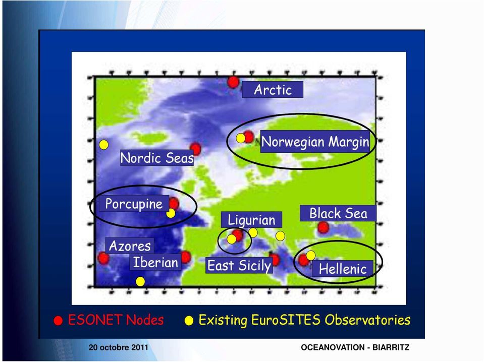
6 Open Sea observatories: A tool complementary to other observation systems allowing: long-term measurements acquisition in real time or near real time, in the water column and on the seafloor, of many parameters of marine environment. 2-way communicating, allowing human intervention in real time when needed. They are innovative systems, bringing Internet in the Ocean and allowing the Ocean reality show 2 observatory types Cable observatory communicating to the shore station via a cable connection Standalone observatory communicating to the shore station via a acoustics and satellite connection

7
8 JERICO Enhanced the coordination between existing coastal observatories Propose common procedure from the sensor to the data quality assessment Enlarge the network with new partners Prepare for the future European Network of operational coastal observatories (OCO)

9 Argos NOREK 6020 RCM9 SBE39 RCM9 2 Rels Argos NOREK 6020 RCM9 SBE39 RCM9 2 Rels The JERICO Infrastructure Network Fixed platforms Ferrybox Fishing vessels Gliders

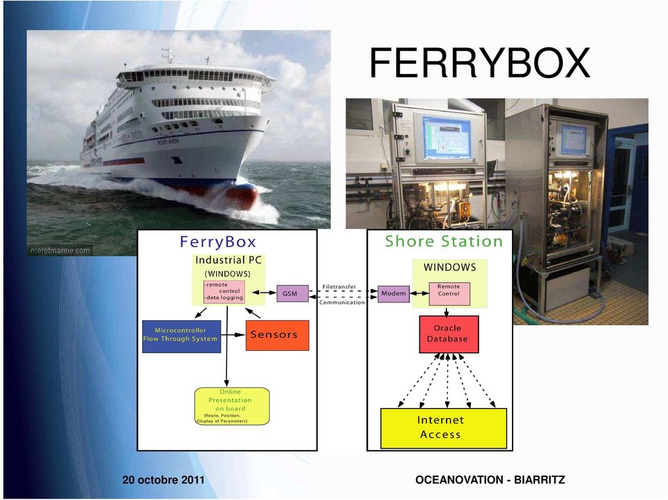
10 FERRYBOX
11 GENERAL DESIGN Static fins GPS/Iridium/Radio (foldable) Air bladder Water-compressibility matching hulls 4 sensor ports (openings) Oil bladder Ballast Unit Control hardware Pitch actuator Li-Ion battery (2.5kWh) Roll actuator Connectors: 10MBitEthernet; Recharge and external power; External sensors Acoustique transducer (Positioning and communications) 11
 Roll actuator Connectors: 10MBitEthernet; Recharge and external power; External")
12
13
14 RADAR COTIER


15 Survey AUVs for Sciences: Cost Optimization of environmental surveillance MultiPayloads to increase rate of usage ASTERx,IDEFx 15

16 Hybrid ROV

Joint European Research Infrastructure Network For Coastal Observatories
 Joint European Research Infrastructure network for Coastal Observatories Second Data Management Report D 5.7 Grant Agreement n 262584 Project Acronym: JERICO Project Title: Towards a Joint European Research
JERICO(FP7) & JERICO-NEXT (H2020) Best Practices and harmonisation. I. Puillat Ifremer Brest - Dyneco/Physed jerico@ifremer.fr
 & JERICO-NEXT (H2020) Best Practices and harmonisation. I. Puillat Ifremer Brest - Dyneco/Physed jerico@ifremer.fr") JERICO(FP7) & JERICO-NEXT (H2020) Best Practices and harmonisation I. Puillat Ifremer Brest - Dyneco/Physed jerico@ifremer.fr www.jerico-fp7.eu Bordeaux 26-27 novembre 2014 JERICO(FP7): WHAT HAVE WE DONE?
JERICO(FP7) & JERICO-NEXT (H2020) Best Practices and harmonisation I. Puillat Ifremer Brest - Dyneco/Physed jerico@ifremer.fr www.jerico-fp7.eu Bordeaux 26-27 novembre 2014 JERICO(FP7): WHAT HAVE WE DONE?
Joint European Research Infrastructure network for Coastal Observatories
 Joint European Research Infrastructure network for Coastal Observatories Delayed Mode Data Management Handbook V1 - D5.1 Grant Agreement n 262584 Project Acronym: JERICO Project Title: Towards a Joint
Building a pan-european observation system for geosciences
 EUROPEAN COMMISSION Research & Innovation Research Infrastructures Building a pan-european observation system for geosciences EU support for research infrastructures in environmental sciences Research
Coriolis data-centre an in-situ data portail for operational oceanography. http://www.coriolis.eu.org codac@ifremer.fr
 Coriolis data-centre an in-situ data portail for operational oceanography Ingrid Puillat on behalf of L. Petit de la Villeon & G. Maudire IFREMER http://www.coriolis.eu.org codac@ifremer.fr 1 How did Coriolis
SeaDataNet pan-european infrastructure for ocean and marine data management and its relation to EMODNet and GEOSS
 SeaDataNet pan-european infrastructure for ocean and marine data management and its relation to EMODNet and GEOSS By Dick M.A. Schaap MARIS SeaDataNet Technical Coordinator Madrid Spain, 26 January 2012,
Coriolis data-centre an in-situ data portail for operational oceanography
 Coriolis data-centre an in-situ data portail for operational oceanography Loïc Petit de la Villéon -Ifremer http://www.coriolis.eu.org codac@ifremer.fr 1 How did Coriolis start to work on operational oceanography?
Establishing and operating an Ocean Data Interoperability Platform ODIP. EU US Australia cooperation
 Establishing and operating an Ocean Data Interoperability Platform ODIP EU US Australia cooperation By Helen Glaves NERC- BGS ODIP Coordinator & Dick M.A. Schaap MARIS ODIP Technical Coordinator Supported
Coriolis, a French project for operational oceanography
 Coriolis, a French project for operational oceanography S Pouliquen *1,T Carval *1,L Petit de la Villéon *1, L Gourmelen *2, Y Gouriou *3 1 Ifremer Brest France 2 Shom Brest France 3 IRD Brest France Abstract
SC2 BIOECONOMY in Horizon 2020
 SC2 BIOECONOMY in Horizon 2020 Food security, sustainable agriculture and forestry, marine and maritime and inland water research and the bioeconomy 19 DICEMBRE 2013 TAVOLA ROTONDA Iniziative e partenariati
NOON. log. Norwegian Ocean Observatory Network by Juergen Mienert
 log NOON Norwegian Ocean Observatory Network by Juergen Mienert Alliance of marine science : from national to global network 1 log TO GET WHERE WE NEED TO GO Observatories as Pioneers for Environmental
Florida Institute of Oceanography
 Florida Institute of Oceanography Dr. William T. Hogarth, Interim Director, FIO & Dr. Jyotika I. Virmani, Associate Director, FIO National Water Quality Monitoring Council New Orleans, LA May 3-5, 2011
HYBRID PEMFC SYSTEM EXPERIMENTATION IN THE SAILBOAT ZERO CO 2
 HYBRID PEMFC SYSTEM EXPERIMENTATION IN THE SAILBOAT ZERO CO 2 www.cea.fr Fuel Cells and Hydrogen for Maritime and Harbour Applications FCH Workshop, Venice, June 14 th, 2013 Didier Bouix / CEA Liten /
The international Argo programme: a revolution for ocean and climate observations Pierre-Yves Le Traon*, Ifremer Coordinator NAOS Equipex Project
 The international Argo programme: a revolution for ocean and climate observations Pierre-Yves Le Traon*, Ifremer Coordinator NAOS Equipex Project * Acknowledgments: NAOS, French Argo, Euro-Argo/Argo international
The Copernicus Marine Enviroment Monitoring Service
 The Copernicus Marine Enviroment Monitoring Service P.Y. Le Traon 7&8 Sep 2015 - CMEMS SE & UU Workshop, Brussels 1 CMEMS : The Copernicus Marine Environment Monitoring Service SATELLITES (S1, S3, Jason-CS)
Fixed point Coastal Observations around Italy
 Fixed point Coastal Observations around Italy A preliminary overview Stefania Sparnocchia (CNR) and Rajesh Nair (OGS) stefania.sparnocchia@ismar.cnr.it, rnair@ogs.trieste.it First JERICO Fixed Platforms
SeaDataNet pan-european infrastructure for ocean and marine data management. Dick M.A. Schaap MARIS
 SeaDataNet pan-european infrastructure for ocean and marine data management By Dick M.A. Schaap MARIS SeaDataNet II Technical Coordinator Co-authors: Michele Fichaut (Ifremer) and Giuseppe Manzella (ENEA)
THEMIS: MARINE RESOURCES MANAGEMENT SOFTWARE SUITE
 THEMIS: MARINE RESOURCES MANAGEMENT SOFTWARE SUITE THEMIS*, A COMPREHENSIVE FISHERIES MANAGEMENT SUITE THEMIS is a comprehensive data integration interface and a crucial tool for maintaining 24-hour fishing
Marine Network for Integrated Data Access (MaNIDA) Portal Deutsche Meeresforschung
 Portal Deutsche Meeresforschung") Helmholtz Impuls- und Vernetzungsfonds Marine Network for Integrated Data Access (MaNIDA) Portal Deutsche Meeresforschung W. Hiller, M. Schulz, G. Breitbach, B. Brügge, A. Lehmann Coordinating Helmholtz
Helmholtz Impuls- und Vernetzungsfonds Marine Network for Integrated Data Access (MaNIDA) Portal Deutsche Meeresforschung W. Hiller, M. Schulz, G. Breitbach, B. Brügge, A. Lehmann Coordinating Helmholtz
Shallow Water Swath Bathymetry from Small Platforms. Advances in Seafloor Mapping Sonar, 30 Dec 2009 Systems Engineering & Assessment Ltd.
 Shallow Water Swath Bathymetry from Small Platforms Advances in Seafloor Mapping Sonar, 30 Dec 2009 Systems Engineering & Assessment Ltd. Presentation Requirements, applications and challenges SWATHplus
The MONGOOS Data portal EMODNET ROOS meeting, Brussels, 18 November 2013
 The MONGOOS Data portal EMODNET ROOS meeting, Brussels, 18 November 2013 Leonidas Perivoliotis Hellenic Center for Marine Research, Greece The MONGOOS Data Portal Collects and process data from Insitu
COUNCIL OF THE EUROPEAN UNION. Brussels, 15 November 2005 14443/05 RECH 212 ENV 529 COSDP 803 TRANS 233 COVER NOTE
 COUNCIL OF THE EUROPEAN UNION Brussels, 15 November 2005 14443/05 COVER NOTE from: RECH 212 ENV 529 COSDP 803 TRANS 233 Secretary-General of the European Commission, signed by Mr. Jordi AYET PUIGARNAU,
A standards-based open source processing chain for ocean modeling in the GEOSS Architecture Implementation Pilot Phase 8 (AIP-8)
") NATO Science & Technology Organization Centre for Maritime Research and Experimentation (STO-CMRE) Viale San Bartolomeo, 400 19126 La Spezia, Italy A standards-based open source processing chain for ocean
NATO Science & Technology Organization Centre for Maritime Research and Experimentation (STO-CMRE) Viale San Bartolomeo, 400 19126 La Spezia, Italy A standards-based open source processing chain for ocean
Coriolis data centre Coriolis-données
 direction de la technologie marine et des systèmes d'information département informatique et données marines Christine Coatanoan Loïc Petit De La Villéon March 2005 COR-DO/DTI-RAP/04-047 Coriolis data
Ocean Observatories Initiative. OOI Data Management. January 15, 2015
 Ocean Observatories Initiative OOI Data Management January 15, 2015 1 Data User Groups OOI CI CONOPS has the following categories of users: Science Education and Outreach OOI Operations Users Data Manager/Evaluators
BIOLOGICAL MONITORING WITH THE WESTERN CANADIAN ODAS MARINE BUOY NETWORK
 BIOLOGICAL MONITORING WITH THE WESTERN CANADIAN ODAS MARINE BUOY NETWORK Jim Gower, Angelica Peña and Ann Gargett Institute of Ocean Sciences, P.O. Box 6, Sidney, BC, V8L 4B2 Tel: 2 363-68, Fax: 363-6746,
SeaDataNet II Proposal
 SeaDataNet II Proposal By Dick M.A. Schaap SeaDataNet Technical Coordinator Angera - Italy, 30 March 2011 SeaDataNet II Overall objective to upgrade the present SeaDataNet infrastructure into an operationally
The European Marine Observation and Data Network
 The European Marine Observation and Data Network EMODnet Open Conference De Grote Post, Oostende, Belgium Tuesday 20 October 2015 info@emodnet.eu cost of ocean observation in EU 1 High level aims Vision
Istanbul Technical University-Center for Satellite Communications and Remote Sensing (ITU-CSCRS)
") Istanbul Technical University-Center for Satellite Communications and Remote Sensing (ITU-CSCRS) Istanbul Technical University, Center for Satellite Communications and Remote Sensing (ITU-CSCRS) was originally
Istanbul Technical University-Center for Satellite Communications and Remote Sensing (ITU-CSCRS) Istanbul Technical University, Center for Satellite Communications and Remote Sensing (ITU-CSCRS) was originally
Université de la Médite TRANSMED: low cost thermosalinometers in the Mediterranean
 www.ciesm.org TRANSMED: a (future) network of low cost thermosalinometers in the Mediterranean I. TAUPIER LETAGE, G. ROUGIER, A. MONTIES and T. FABIANI CNRS/UNIVERSITÉ DE LA MÉDITERRANÉE ANTENNEDETOULON
Maintenance and Disposition. Ocean and Marine Technology Functional Files. Function Number 1800
 Maintenance and Disposition Ocean and Marine Technology Functional Files Function Number 1800 Function number 1800 deal with program related to ocean and marine technology promotion, evaluation, and information.
Offshore monitoring for geological storage
 Offshore monitoring for geological storage Dr Douglas Connelly National Oceanography Centre University of Southampton Waterfront Campus Southampton dpc@noc.soton.ac.uk IEAGHG Taking stock of progress and
The Copernicus Marine Environment and Monitoring Service
 The Copernicus Marine Environment and Monitoring Service Pierre Bahurel, Mercator Ocean Marine data and information powering Blue Growth European Maritime Day, Athens, 28-29 May 2015 Search & Rescue in
Integrating Near Real-Time Data for Coral Reef Ecosystem Forecasting
 Integrating Near Real-Time Data for Coral Reef Ecosystem Forecasting NOAA s Integrated Coral Observing Network (ICON) Atlantic Oceanographic and Meteorological Laboratory Laboratory Review, March 18, 2008
THE FUTURE OF THE OCEAN ECONOMY: AN OECD/IFP FORESIGHT PROJECT
 THE FUTURE OF THE OCEAN ECONOMY: EXPLORING THE PROSPECTS FOR EMERGING OCEAN INDUSTRIES TO 2030 AN OECD/IFP FORESIGHT PROJECT BARRIE STEVENS OECD/DSTI Verftskonferansen 2013 Alesund, Norway, 5 th November
A DAY FOR CARTOGRAPHIC SYSTEMS TO MANAGE COASTAL ZONES
 A DAY FOR CARTOGRAPHIC SYSTEMS TO MANAGE COASTAL ZONES Coastal and maritime data: common heritage, a capital to be shared, a challenge for innovation in Europe 10th December 2009 Provence-Alpes-Côte d
ARMATEURS DE FRANCE S BLUE CHARTER. For responsible transport and maritime services
 ARMATEURS DE FRANCE S BLUE CHARTER For responsible transport and maritime services PREAMBLE As actors of globalization, French shipowners are committed to providing competitive transport and maritime services
ROADMAP ON MARINE RENEWABLE ENERGY
 FAME PROJECT - INTERNATIONAL WORKSHOP TERESA SIMAS 1 20 TH NOVEMBER, 2012 OBJECTIVES Overview of marine renewable energy development and prospects CONTENTS Green House Gas emissions targets Renewable energy
Permanent Reservoir Monitoring (PRM) System Installation: The Installers Perspective
 System Installation: The Installers Perspective") Permanent Reservoir Monitoring (PRM) System Installation: The Installers Perspective Introduction Global Marine Systems Limited (Global Marine) has a vast wealth of knowledge in designing planning and
Permanent Reservoir Monitoring (PRM) System Installation: The Installers Perspective Introduction Global Marine Systems Limited (Global Marine) has a vast wealth of knowledge in designing planning and
CFD Modelling and Real-time testing of the Wave Surface Glider (WSG) Robot
 Robot") 21st International Congress on Modelling and Simulation, Gold Coast, Australia, 29 Nov to 4 Dec 2015 www.mssanz.org.au/modsim2015 CFD Modelling and Real-time testing of the Wave Surface Glider (WSG) Robot
21st International Congress on Modelling and Simulation, Gold Coast, Australia, 29 Nov to 4 Dec 2015 www.mssanz.org.au/modsim2015 CFD Modelling and Real-time testing of the Wave Surface Glider (WSG) Robot
CTD Oceanographic Tags
 CTD Oceanographic Tags The first telemetry tag that links a marine mammal s behavior with its physical environment. Features: Oceanographic quality temperature & salinity profiles Detailed individual dive
The BEAMS Program College of Charleston & University of Washington
 The BEAMS Program College of Charleston & University of Washington Development of the Marine Survey Workforce Leslie R. Sautter, Ph.D. Scott Harris, Ph.D. Dept. of Geology and Environmental Geosciences
SATELLITE OCEANOGRAPHY IN THE AZORES: PAST, PRESENT AND FUTURE
 SATELLITE OCEANOGRAPHY IN THE AZORES: PAST, PRESENT AND FUTURE Oceanography Section / DOP University of the Azores Ana Martins Email: anamartins@uac.pt Azores (NE Atlantic) - very exposed to harsh environments
The distribution of marine OpenData via distributed data networks and Web APIs. The example of ERDDAP, the message broker and data mediator from NOAA
 The distribution of marine OpenData via distributed data networks and Web APIs. The example of ERDDAP, the message broker and data mediator from NOAA Dr. Conor Delaney 9 April 2014 GeoMaritime, London
Observing systems at Spain
 Observing systems at Spain Alicia Lavín Instituto Español de Oceanografía Centro Oceanográfico de Santander European Maritime Day Gijón n May 19, 2010 Historic time series: sea level and SST Nivel del
7th Framework Programme Theme 6 Environment (including climate change)
") 7th Framework Programme Theme 6 Environment (including climate change) «Environnement» et «Énergie» Programme D. Deybe DG RTD Environment Directorate 1 Cooperation Collaborative Research Ten themes 1.
7th Framework Programme Theme 6 Environment (including climate change) «Environnement» et «Énergie» Programme D. Deybe DG RTD Environment Directorate 1 Cooperation Collaborative Research Ten themes 1.
TROPICAL ATMOSPHERE-OCEAN (TAO) PROGRAM FINAL CRUISE REPORT TT-15-01. Area: Equatorial Pacific: 8 N 95 W to 8 S 95 W and 8 S 110 W to 8 N 110 W
 PROGRAM FINAL CRUISE REPORT TT-15-01. Area: Equatorial Pacific: 8 N 95 W to 8 S 95 W and 8 S 110 W to 8 N 110 W") TROPICAL ATMOSPHERE-OCEAN (TAO) PROGRAM FINAL CRUISE REPORT TT-15-01 Area: Equatorial Pacific: 8 N 95 W to 8 S 95 W and 8 S 110 W to 8 N 110 W Itinerary: TT-15-01 DEP April 6, 2015, San Diego, CA ARR May
TROPICAL ATMOSPHERE-OCEAN (TAO) PROGRAM FINAL CRUISE REPORT TT-15-01 Area: Equatorial Pacific: 8 N 95 W to 8 S 95 W and 8 S 110 W to 8 N 110 W Itinerary: TT-15-01 DEP April 6, 2015, San Diego, CA ARR May
telemetry Rene A.J. Chave, David D. Lemon, Jan Buermans ASL Environmental Sciences Inc. Victoria BC Canada rchave@aslenv.com I.
 Near real-time transmission of reduced data from a moored multi-frequency sonar by low bandwidth telemetry Rene A.J. Chave, David D. Lemon, Jan Buermans ASL Environmental Sciences Inc. Victoria BC Canada
Instrumentation for Monitoring around Marine Renewable Energy Devices
 Instrumentation for Monitoring around Marine Renewable Energy Devices 1 Introduction As marine renewable energy has developed, a set of consistent challenges has emerged following attempts to understand
Space radar technologies for oil spills management, detection of illegal fishing and logging activities
 Space radar technologies for oil spills management, detection of illegal fishing and logging activities VIGISAT The French satellite ground receiving station VIGISAT 2009 know today, live better tomorrow
Pan-European infrastructure for management of marine and ocean geological and geophysical data
 Pan-European infrastructure for management of marine and ocean geological and geophysical data By Dick M.A. Schaap Geo-Seas Technical Coordinator March 2010 Supported by the European Commission FP7 - Research
Schedule of Construction. Project Management and Control
 Ocean Observatories Initiative Schedule of Construction Project Management and Control Anthony Ferlaino OOI Project Manager Science Community Workshop I Baltimore, Nov 11-12, 2009 Process Controls of a
Sensing, monitoring and actuating on the UNderwater world through a federated Research InfraStructure Extending the Future Internet SUNRISE
 Sensing, monitoring and actuating on the UNderwater world through a federated Research InfraStructure Extending the Future Internet SUNRISE Grant Agreement number 611449 Announcement of the Second Competitive
Sextant. Spatial Data Infrastructure for Marine Environment. C. Satra Le Bris, E. Quimbert, M. Treguer
 Sextant On-Line information system for marine geographical information E. Quimbert, M. Bellouis, F. Lecuy, M. Treguer Centre de Bretagne BP 70, Plouzané 29280 France E-mail: sextant@ifremer.fr Sextant
Perspektiv fra en faglig ansatt
 Perspektiv fra en faglig ansatt Geir Johnsen, NTNU Strategiske partnerskap og allianser hva får vi ut av dem case NORUS Forskning Hands On Undervisning Fremtidige partnerskap og allianser SiU funded NORUS
Maritime Renewable Technology (MRT) JoEllen Rose Marine Renewables Engineer October 2011
 JoEllen Rose Marine Renewables Engineer October 2011") Maritime Renewable Technology (MRT) JoEllen Rose Marine Renewables Engineer October 2011 Technology Review Tidal Wave/Ocean Current Pelamis Oyster Wavebob ORPC Verdant Power Offshore Wind Poseidon wind/wave
Maritime Renewable Technology (MRT) JoEllen Rose Marine Renewables Engineer October 2011 Technology Review Tidal Wave/Ocean Current Pelamis Oyster Wavebob ORPC Verdant Power Offshore Wind Poseidon wind/wave
How Efficient Is Your Hybrid?
 How Efficient Is Your Hybrid? Legal and Regulatory Consequences of Deploying Undersea Telecommunications Cables with Additional Energy- or Scientific Research-Related Functions Kent Bressie 13 April 2011
Woods Hole Group, Inc. Oceanography and Measurement Systems Division INTEGRATED REAL-TIME MONITORING SYSTEM
 Woods Hole Group, Inc. INTEGRATED REAL-TIME MONITORING SYSTEM Woods Hole Group, Inc. (WHG) has developed the Integrated Real-time Monitoring System (IRMS) as a general-purpose data acquisition and telemetry
CONTRIBUTION TO THE ROUND TABLE
 Il sistema marno costiero Networking territoriale della conoscenza: un opportunità per la Regione Emilia Romagna Bologna, 8 Giugno 2015 CONTRIBUTION TO THE ROUND TABLE DISCUSSION Fabio Fava University
ESONEWS The Newsletter of the European Sea Observatory Network
 Volume 1 Issue 3 ESONEWS The Newsletter of the European Sea Observatory Network ESONIM... 1 Flashes / Short News... 6 Company Profile: nke... 7 Welcome to the last Esonews 27!...8 The objective of the
Advances in Unmanned Surface Vessels (USV s) James Williams Managing Director
 James Williams Managing Director") Advances in Unmanned Surface Vessels (USV s) James Williams Managing Director 1 Abstract Advances in Unmanned Surface Vessels (USV s) James Williams, Managing Director, Swathe Services Group, UK Advanced
Advances in Unmanned Surface Vessels (USV s) James Williams Managing Director 1 Abstract Advances in Unmanned Surface Vessels (USV s) James Williams, Managing Director, Swathe Services Group, UK Advanced
One potential cross-thematic call on "The Ocean of Tomorrow" is proposed, following the single stage procedure: FP7-OCEAN-2013 with 4 topics
 Ref. Ares(2012)466557-17/04/2012 ORIENTATION PAPER FOR "THE OCEAN OF TOMORROW 2013" CALL prepared in connection with the FP7 2013 Work Programme in the area of Food, Agriculture and Fisheries, and Biotechnology
Update on EUMETSAT ocean colour services. Ewa J. Kwiatkowska
 Update on EUMETSAT ocean colour services Ewa J. Kwiatkowska 1 st International Ocean Colour Science meeting, 6 8 May, 2013 EUMETSAT space data provider for operational oceanography Operational data provider
The Integration of Hydrographic and Oceanographic Data in a Marine Geographic Information System U.S. Hydro 2015
 The Integration of Hydrographic and Oceanographic Data in a Marine Geographic Information System U.S. Hydro 2015 Karen Hart CARIS USA Oceanography and Hydrography Defined Oceanography: The branch of Earth
MDM Lab Laboratory of Mechatronics and Dynamic Modelling. Dall Ingegneria Ferroviaria alla Robotica Subacquea
 MDM Lab Laboratory of Mechatronics and Dynamic Modelling Dall Ingegneria Ferroviaria alla Robotica Subacquea Benedetto Allotta benedetto.allotta@unifi.it Alessandro Ridolfi a.ridolfi@unifi.it Laboratorio
For the PNTL Fleet, which are all purpose built vessels, certified to INF3 classification [3] such prevention measure include the following:
![For the PNTL Fleet, which are all purpose built vessels, certified to INF3 classification [3] such prevention measure include the following:](/thumbs/25/5282963.jpg "For the PNTL Fleet, which are all purpose built vessels, certified to INF3 classification [3] such prevention measure include the following:") Emergency Response Arrangements for the Pacific Nuclear Transport Fleet M. Fox International Transport, British Nuclear Fuels plc, Warrington, Cheshire, United Kingdom Abstract. Whilst the likelihood of
Emergency Response Arrangements for the Pacific Nuclear Transport Fleet M. Fox International Transport, British Nuclear Fuels plc, Warrington, Cheshire, United Kingdom Abstract. Whilst the likelihood of
COMMUNICATION FROM THE COMMISSION TO THE EUROPEAN PARLIAMENT AND THE COUNCIL
 EUROPEAN COMMISSION Brussels, 8.7.2014 COM(2014) 451 final COMMUNICATION FROM THE COMMISSION TO THE EUROPEAN PARLIAMENT AND THE COUNCIL Better situational awareness by enhanced cooperation across maritime
Total Subsea Solutions
 Total Subsea Solutions Total Subsea Solutions Developing new energy reserves, managing, and improving producing fields means an unprecedented number of technical challenges. In partnership with our customers,
Request for Quote: Marine Vessel May 16, 2014
 RFQ: Marine Vessel Request for Quote: Marine Vessel May 16, 2014 1.0 INTRODUCTION Industrial Economics, Incorporated (IEc) is seeking a qualified subcontractor(s) to provide an oceangoing vessel to support
 Preface The term algal bloom is used to describe the temporal and spatial accumulation of phytoplankton in general or a single species in an aquatic environment. The phenomenon of water discoloration produced
HELLENIC NATIONAL OCEANOGRAPHIC DATA CENTRE
 1 HELLENIC NATIONAL OCEANOGRAPHIC DATA CENTRE Sissy Iona HCMR, GREECE JCOMM/DMPA COORDINATOR IODE CO-CHAIR NOAA Science Seminars, NOAA/NODC,SSMC III, E/OC5, Silver Spring, History 2 It was established
NDBC s Smart Module Applications
 NDBC s Smart Module Applications National Data Buoy Center Stennis Space Center, MS. Rodney Riley INMARTECH 2014, Corvallis Oregon Smart Module History In 2008, started development to convert (dumb) analog
PARTNER PROFILE. If you are interested to join the partnership for the upcoming EU calls for proposals please fill in the following questions:
 PARTNER PROFILE If you are interested to join the partnership for the upcoming EU calls for proposals please fill in the following questions: Organisation (name, address, department, contact person, tel.,
The Gulf of Maine Ocean Observing System
 The Gulf of Maine Ocean Observing System Overview of remarks 1. Purpose of GoMOOS 2. Governance : User-Driven Nonprofit 3. User Community & Applications Purpose #1. Facilitate safe and efficient marine
Mobile Phone Based Drifting Lagrangian Flow Sensors
 Mobile Phone Based Drifting Lagrangian Flow Sensors J. Beard, K. Weekly, C. Oroza, A. Tinka, A. Bayen University of California Berkeley Departments of Mechanical, Electrical, Computer Science, Civil, and
Au service de vos projets maritimes et fluviaux
 INGÉNIERIE CONSEIL MESURES ENVIRONNEMENTALES Au service de vos projets maritimes et fluviaux Marine Renewable Energies Our services: Impact assessments Regulatory studies Resource and energy assessment
Cruise Report. OSU R/V Oceanus OC1405B. Cascadia Initiative Leg 2 May 28 to June 1 Newport, OR Newport OR. Matt Fowler Chief Scientist
 Cruise Report OSU R/V Oceanus OC1405B Cascadia Initiative Leg 2 May 28 to June 1 Newport, OR Newport OR Matt Fowler Chief Scientist Captain and Crew: R/V Oceanus: Captain: Jeff Crews Chief Engineer: Jonathan
National Data Buoy Center Cooperative Relations
 National Data Buoy Center Cooperative Relations Presentation For NGI Annual Conference May 23, 2012 Landry Bernard National Data Buoy Center Operational Mission To provide a real-time, end-to-end capability
REMOTE MONITORING SOLUTIONS COASTAL, ESTUARY AND INLAND WATERWAYS PRODUCTS, SERVICES & PROJECT SOLUTIONS
 REMOTE MONITORING SOLUTIONS COASTAL, ESTUARY AND INLAND WATERWAYS PRODUCTS, SERVICES & PROJECT SOLUTIONS CUSTOMER CHALLENGES. PENTAIR SOLUTIONS. BETTER MONITORING BETTER RESULTS MARINE ELECTRONIC HIGHWAY
ap Observing System (FOOS)
") SSD-Pesca: the Fisheries es Oceanography ap Observing System (FOOS) Bernardo Patti CNR-IAMC, Capo Granitola, Campobello di Mazara (TP), Italy The fishing Vessel Monitoring System (VMS) is a satellite-based
SSD-Pesca: the Fisheries es Oceanography ap Observing System (FOOS) Bernardo Patti CNR-IAMC, Capo Granitola, Campobello di Mazara (TP), Italy The fishing Vessel Monitoring System (VMS) is a satellite-based
The Development of IALA-NET Data Center in China. Maritime Safety Administration (MSA) of the People's Republic of China
 of the People's Republic of China") The Development of IALA-NET Data Center in China Maritime Safety Administration (MSA) of the People's Republic of China IALA-NET is an IALA project It will be implemented if the trial demonstrates its
The Development of IALA-NET Data Center in China Maritime Safety Administration (MSA) of the People's Republic of China IALA-NET is an IALA project It will be implemented if the trial demonstrates its
It also covers the following optional activities:
 2 PROJECT DESCRIPTION UPDATE 2.1 INTRODUCTION The Original EMPr evaluated the potential impacts of 2D seismic surveys in the Exploration Area. Two seismic surveys were subsequently carried out: one in
http://www.youtube.com/watch? v=pe-1g_476na&feature=player_embed
 On April 20, 2010, the explosion of the BP Deepwater Horizon oil drilling platform, located 90 km offshore in the Mississippi Canyon, caused a 87-day blowout of the Macondo well. During this period, crude
Past, Present and Future
 EBFMtuna 2012 Towards ecosystem based management of tuna fisheries Evolution Of RadiobuoysTechnology For FADs Past, Present and Future Francisco Pino R&D Director Montpellier, October 2012 Beginnings Tunaseiner
How To Build An Open Cabled Infrastructure In Medsea
 A New Open Cabled Infrastructure in Medsea P.Leon, JF.Drogou, D.Chenot, C.Leveque, H.Martinossi, A.Massol, V.Rigaud, D.Santarelli, P.Valdy IFREMER France C.Gojak, K.Bernardet, Z.Hafidi, Y.Lenault, K.Mahiouz
Survey Sensors Hydrofest 2014. Ross Leitch Project Surveyor
 Survey Sensors Hydrofest 2014 Ross Leitch Project Surveyor Satellite Positioning Only provides position of antenna Acoustic Positioning Only provides position of transponder relative to transceiver How
EMODNET Preparatory Actions Hydrographic and Seabed Mapping
 EMODNET Preparatory Actions Hydrographic and Seabed Mapping Service Contracts MARE/2008/03 S12.531515 and MARE/2009/07 S12.563144 By Dick M.A. Schaap Coordinator Hydrographic and Seabed Mapping partnership
13 th EC GI & GIS Workshop WIN: A new OGC compliant SOA. for risk management. GMV, 2007 Property of GMV All rights reserved
 13 th EC GI & GIS Workshop WIN: A new OGC compliant SOA for risk management GMV, 2007 Property of GMV All rights reserved Content 1. Introduction 2. Objectives 3. Architecture and Model 4. Technical aspects
Improving Hydrographic Rate of Effort
 Improving Hydrographic Rate of Effort Presented by Scott Elson Australia s Surveying Responsibility Source: http://www.hydro.gov.au/business-publications/hydroscheme-2010-2012.pdf Company Proprietary 2
The Biodiversity Information System for Europe - BISE -
 The Biodiversity Information System for Europe - BISE - Sabine Roscher Dominique Richard European Topic Centre Biological Diversity (ETC/BD) Meeting of the Group of experts on Protected Areas and ecological
(0008854) A981653 REV B. 4125 system setup and deployment quick start guide
 A981653 REV B. 4125 system setup and deployment quick start guide") (0008854) A981653 REV B 4125 system setup and deployment quick start guide OPERATION IN AIR Do not operate the system while the tow fish in air for extended periods. The system may be enabled to transmit
(0008854) A981653 REV B 4125 system setup and deployment quick start guide OPERATION IN AIR Do not operate the system while the tow fish in air for extended periods. The system may be enabled to transmit
Met Office. Observations Supply. Marine Networks
 Met Office Observations Supply Marine Networks 1 00/XXXX Crown copyright MARINE NETWORKS VOS (& VOSClim) Offshore Units Moored Buoys Drifting Buoys ASAP 2 00/XXXX Crown copyright Port Met Offices Aberdeen
Finnish Marine Research Infrastructure FINMARI
 Finnish Marine Research Infrastructure FINMARI Lauri Laakso, Finnish Meteorological Institute Timo Tamminen, Finnish Environment Institute Finnish Meteorological Institute 1. National roadmap for key research
DISMAR: Data Integration System for Marine Pollution and Water Quality
 DISMAR: Data Integration System for Marine Pollution and Water Quality T. Hamre a,, S. Sandven a, É. Ó Tuama b a Nansen Environmental and Remote Sensing Center, Thormøhlensgate 47, N-5006 Bergen, Norway
A little on Marine Core Services
 A little on Marine Core Services Copernicus Services -> CLOSE WATCH -> RELIABLE and UP-TO-DATE information 6 thematic areas: Land Monitoring Operational Emergency Management Operational Atmosphere Monitoring
Towed Streamer Positioning System
 Towed Streamer Positioning System Performance Data s towed streamer positioning system reduces the positional uncertainty for the entire towed streamer array by integrating horizontal and vertical streamer
Annex VIII. Development of the portal site on remote sensing. (Reviewed by the Second Meeting of NOWPAP WG4)
") Page 1 Development of the portal site on remote sensing (Reviewed by the Second Meeting of NOWPAP WG4) Page 1 Development of the portal site on remote sensing 1 Background Based on the consideration in
Page 1 Development of the portal site on remote sensing (Reviewed by the Second Meeting of NOWPAP WG4) Page 1 Development of the portal site on remote sensing 1 Background Based on the consideration in
Contents. 1. PROFILE p2. 2. SERVICES 2.1 Offshore Support Services p 4 Offshore support p 6 ROV operations p 8
 OCTOBER 2013 22 Contents 1. PROFILE p2 2. SERVICES 2.1 Offshore Support Services p 4 Offshore support p 6 ROV operations p 8 2.2 Hydrographic & Geophysical services p 10 Bathymetric surveys p 12 High resolution
Research, Development and Testing at NNMREC and PMEC. Belinda Batten. Director, Northwest National Marine Renewable Energy Center
 Research, Development and Testing at NNMREC and PMEC Belinda Batten Director, Northwest National Marine Renewable Energy Center National Marine Renewable Energy Centers Northwest National Marine Renewable
THE CORAL TRIANGLE INITIATIVE (CTI) ON CORAL REEFS, FISHERIES AND FOOD SECURITY. 1st Sulu Sulawesi Sea (SSS) Conference 18-19 November 2015
 ON CORAL REEFS, FISHERIES AND FOOD SECURITY. 1st Sulu Sulawesi Sea (SSS) Conference 18-19 November 2015") THE CORAL TRIANGLE INITIATIVE (CTI) ON CORAL REEFS, FISHERIES AND FOOD SECURITY 1st Sulu Sulawesi Sea (SSS) Conference 18-19 November 2015 1 Introduction to CTI PRESENTATION OUTLINE State of the CTI Marine
THE CORAL TRIANGLE INITIATIVE (CTI) ON CORAL REEFS, FISHERIES AND FOOD SECURITY 1st Sulu Sulawesi Sea (SSS) Conference 18-19 November 2015 1 Introduction to CTI PRESENTATION OUTLINE State of the CTI Marine