Past, Present and Future
|
|
|
- Joshua Lewis
- 7 years ago
- Views:
Transcription
1 EBFMtuna 2012 Towards ecosystem based management of tuna fisheries Evolution Of RadiobuoysTechnology For FADs Past, Present and Future Francisco Pino R&D Director Montpellier, October 2012

2 Beginnings Tunaseiner fleet started using FADs Need of tracking FADs at sea 2

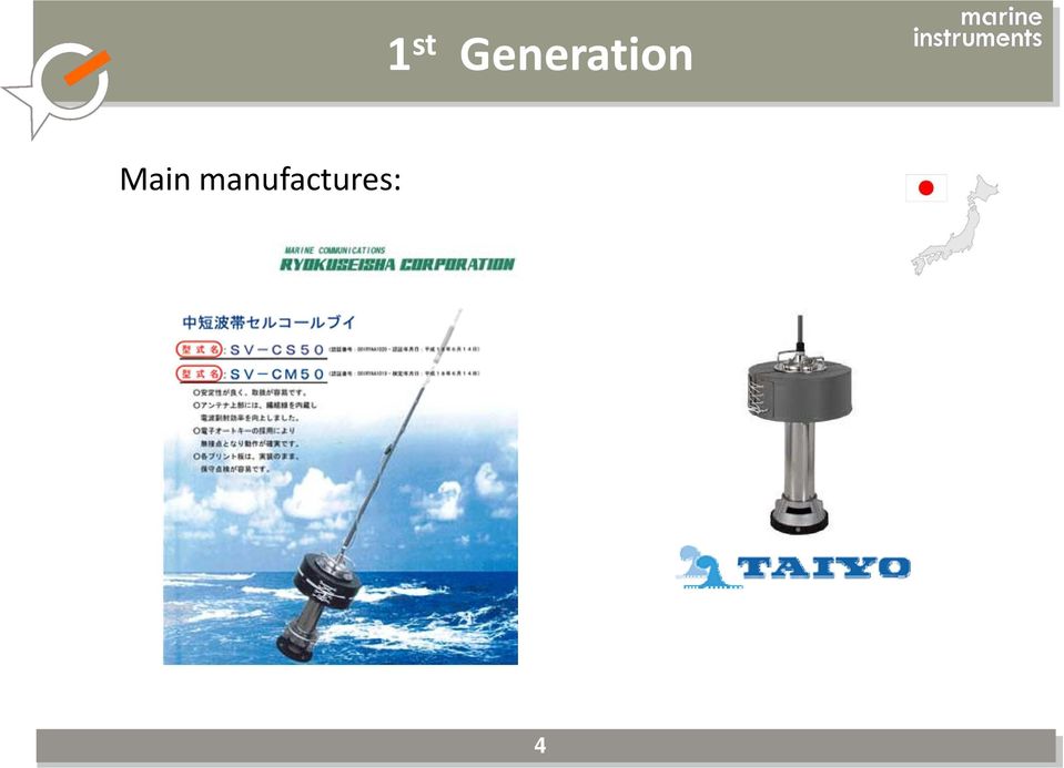
3 1 st Generation SELCALL BUOYS Goniometric reception Only radio direction Limited range coverage <500nm Very extended over the world No airtime i cost Up to date in longliners 3

4 1 st Generation Mi Main manufactures: 4
5 2 nd Generation First SOUNDER BUOY SelCall with a fish finder inside Reception by Meteo Fax Long transmission time Limited range Good operation Easy radio detectable No commercial success High cost 5

6 3 rd Generation ARGOS SATELLITE BUOY Worldwide Coverage. airtime communications costs. Argos Network not optimized for tuna radio buoys. UHF radio messages every 90 seconds. Communications intercepted with radio directional finder. Buoys stolen. No success in tuna fleets. 6

7 4 th Generation GPS RADIO BUOY SelCall Radio Buoy Manually radio operated 7

8 4 th Generation HF Radio buoy. Automatic Transmissions every hour. Water temperature, Battery level. Range over 1000 nm. Frequency change. No interceptions. Automatic reception onboard. PC software managing the radio receiver. Reception of every buoy 24 times a day. Observation of real currents. Automatic reception. 3 Oceans 90% European fleets 8

9 5 th Generation SOLAR SATELLITE BUOY Solar Buoy Inmarsat Satellite. Multibeam Echosounder. Young company. Big challenge. Technical difficulties at sea. 9

10 5 th Generation Two new manufactures: HF GPS Radio Buoys Satellite Radio Buoys Satellite Inmarsat D+ Radio Buoys Battery energy 10

11 5 th Generation First radio buoys with reliable echosounder informations.. No surprise, detection of fish in advance. Large fuel savings M3iBlue Buoy Own 50KHz echosounder Simrad 190KHz echosounder 11

12 M3i Buoy 12

13 M3i Buoy Telecommands Pacific Ocean Evolution of fish below the FAD Probably caught 13

14 M3i Buoy Fish is coming Pacific Ocean Fish under the FAD only for few days Small fish shoal 14

15 M3i Buoy Al Atlantic Ocean Fish very faithful to the FAD First plankton After few days nice fish shoal A shoal probably with some detections of Bigeye 15

16 M3i Buoy Telecommands Indian Ocean M3i ACHIEVEMENTS : 1) Good idea of the size of the school. 2) Drastically reduction of the CO2 emission tons per tuna catch tons The M3ican t help you to discriminatespecies species 16

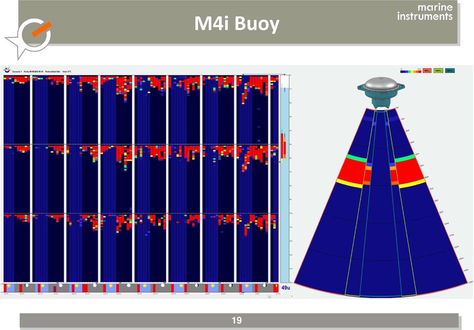
17 6 th Generation Tri frequency sounder buoy: 50KHz, 120 KHz and 200KHz. M4i Buoy Newconcepts: Different frequencies, aperture angleoftransducer transducer. Not only presence or absence of fish and quantities. The way to discriminate species by acoustic signatures. 17

18 M4i Buoy 18

19 M4i Buoy 19
20 What we need? Where are we going? Discrimination sizes and species with high technology sonar? The intensity of the echo received is not more the size of the fish!! 20

21 What we need? Where are we going? FADs that can be driven away from the coast? Driven to a meeting point? To a different current? 21
22 What we need? Where are we going? 22
23 What we need? Where are we going? We need to have a right management of the resource in the oceans Electronic instruments manufacturers Help the scientist to observe. Help fishers to work in the best ecological and sustainable way. MERCI POUR VOTRE ATTENTION!! 23
The use of echo-sounder buoys in purse seine fleets fishing with DFADs in the eastern Pacific Ocean
 The use of echo-sounder buoys in purse seine fleets fishing with DFADs in the eastern Pacific Ocean Moreno 1, G., Murua 2, J., Restrepo 1, V. Summary Tuna purse seine fishers utilizing Drifting Fish Aggregating
THEMIS: MARINE RESOURCES MANAGEMENT SOFTWARE SUITE
 THEMIS: MARINE RESOURCES MANAGEMENT SOFTWARE SUITE THEMIS*, A COMPREHENSIVE FISHERIES MANAGEMENT SUITE THEMIS is a comprehensive data integration interface and a crucial tool for maintaining 24-hour fishing
RESEARCH SHIP ELLEN KHUZWAYO
 RESEARCH SHIP ELLEN KHUZWAYO BACKGROUND: Ellen Khuzwayo, was built according to a Norwegian design by FAROCEAN Marine in Cape Town and commissioned in 2007, she is the newest addition to the Department
MADAGASCAR REPORT MADAGASCAR FISHERIES DATA MANAGEMENT
 44 MADAGASCAR REPORT MADAGASCAR FISHERIES DATA MANAGEMENT Total production statistics have various sources, particularly from logbook, from activities report, from evaluations and projections. It is 120
Havforskningsinstituttet
 to conduct Marine Scientific Research Versjon: 1.02 Opprettet: 11.12.2013 Skrevet av: BTC Godkjent av: KRR Gjelder fra: 11.12.2013 Standard Sidenr: 1 av 6 Application for Consent to conduct Marine Scientific
Lesson 6: Fisheries Management in the Open Ocean. Open Ocean
 !!! Open Ocean Concepts How does fishing equipment affect the amount of fish and bycatch caught in a fishery? How can we change the way we fish to use the ocean better? Standards Addressed HCPS 5. & 5.2
technology Regional Fisheries Livelihoods Programme for South and Southeast Asia (RFLP) Lessons learned notes
 Lessons learned notes") Regional Fisheries Livelihoods Programme for South and Southeast Asia (RFLP) Lessons learned notes Information and communications technology for small-scale fishers and fishing administrations Information
Regional Fisheries Livelihoods Programme for South and Southeast Asia (RFLP) Lessons learned notes Information and communications technology for small-scale fishers and fishing administrations Information
The need to ban fish aggregating devices (FADs) to save juvenile baby tunas. Greenpeace uncovers trade in juvenile tuna in General Santos Fish Port
 to save juvenile baby tunas. Greenpeace uncovers trade in juvenile tuna in General Santos Fish Port") The need to ban fish aggregating devices (FADs) to save juvenile baby tunas 2 December 2014 Quezon City, Philippines Greenpeace uncovers trade in juvenile tuna in General Santos Fish Port Introduction
The need to ban fish aggregating devices (FADs) to save juvenile baby tunas 2 December 2014 Quezon City, Philippines Greenpeace uncovers trade in juvenile tuna in General Santos Fish Port Introduction
FISHERIES Treaty between CANADA and the UNITED STATES OF AMERICA Washington, May 26, 1981 In force July 29, 1981
 FISHERIES Treaty between CANADA and the UNITED STATES OF AMERICA Washington, May 26, 1981 In force July 29, 1981 TREATY BETWEEN THE GOVERNMENT OF CANADA AND THE GOVERNMENT OF THE UNITED STATES OF AMERICA
PMEL Press Releases and NOAA News Stories FY09- FY14
 PMEL Press Releases and NOAA News Stories FY09- FY14 PMEL WIDE Oceanographer named to head NOAA s Seattle research laboratory http://www.noaanews.noaa.gov/stories2011/20111018_pmel.html CLIMATE THEME most
ADS Chapter 564 Security Communications
 ADS Chapter 564 Security Communications Document Quality Check Date: 10/02/2012 Partial Revision Date: 12/30/2011 Responsible Office: SEC/CTIS File Name: 564_100212 12/30/2011 Partial Revision Functional
Bio-Economic Tradeoffs among Gears and Fleet Dynamics of Tuna Purse-Seiner Fishery
 TECHNICAL EXPERTS WORKSHOP ON THE MANAGEMENT OF THE CAPACITY OF THE TUNA FISHING FLEET IN THE EPO, Cartagena de Indias, Colombia, 23-25 April 2014 Bio-Economic Tradeoffs among Gears and Fleet Dynamics
NON-TAR GE T FINFISH SPE CIES AND SMALL TARGET SPECIES
 K obe I I B ycatch W or kshop B ack gr ound Paper NON-TAR GE T FINFISH SPE CIES AND SMALL TARGET SPECIES 1. Overview... 1 2. Information and resources for addressing bycatch... 2 3. Research and management
Improving Hydrographic Rate of Effort
 Improving Hydrographic Rate of Effort Presented by Scott Elson Australia s Surveying Responsibility Source: http://www.hydro.gov.au/business-publications/hydroscheme-2010-2012.pdf Company Proprietary 2
ONLY SAILOR BRINGS YOU LIVE SPORTS OUT HERE
 ONLY SAILOR BRINGS YOU LIVE SPORTS OUT HERE WELCOME TO ANOTHER LEAGUE It s been 23 days since I saw my kids. Another 7 until leave. Supposed to be high winds and rain on my shift. Sure would be nice to
ICCAT Newsletter No. 21
 ICCAT Newsletter No. 21 February 2015 MESSAGE FROM THE ICCAT EXECUTIVE SECRETARY The ICCAT Secretariat has the pleasure to present its readers with ICCAT Newsletter No. 21, informing about the latest events
Report on the international workshop on the use of acoustic data from fishing vessels
 Report on the international workshop on the use of acoustic data from fishing vessels Schiphol airport, Exchange avenue Friday 12 June 2015 Introduction The use of acoustic information from commercial
How To Help Oceans
 The World Bank & the Ocean A Healthy & Productive Ocean to Help Reduce Poverty Why oceans matter to the World Bank NUTRITION Seafood provides 16% of the world s animal protein 1 billion people in developing
Survey Sensors Hydrofest 2014. Ross Leitch Project Surveyor
 Survey Sensors Hydrofest 2014 Ross Leitch Project Surveyor Satellite Positioning Only provides position of antenna Acoustic Positioning Only provides position of transponder relative to transceiver How
IOTC Regional Observer Scheme
 IOTC Regional Observer Scheme OBSERVER TRIP REPORT Observer name : Nationality : IOTC Certification No. : Vessel name : IOTC Registration No. : Vessel type : Trip started : Trip ended : 99 I. Trip summary
SMART FISHING INITIATIVE RESULTS 2010 - JUNE 2016 RESULTS 2010-2016. WWF s 2020 VISION Our oceans are wellmanaged,
 Brent Stirtion/Getty Images RESULTS 2010-2016 WWF s 2020 VISION Our oceans are wellmanaged, healthy, robust and full of life, providing valuable services for the well-being of humanity. SMART FISHING INITIATIVE
Ecosystem perspective on ORs & OCTs
 Workshop on the Application of an Ecosystem Approach for development of Sustainable Aquaculture in Europe s Outermost Regions and Overseas Countries and Territories Session 3: Stakeholders presentations
Newsletter- Special Indonesia
 Newsletter- Special Indonesia What is Handline Tuna Fishing? fishing-living.org Indonesia is the largest tuna-producing country in the world, contributing over 15% of global tuna production. In Indonesia,
13. Steps 3.1 & 3.2. Develop objectives, indicators and benchmarks. Essential EAFM Date Place. Version 1
 13. Steps 3.1 & 3.2 Develop objectives, indicators and benchmarks Essential EAFM Date Place Version 1 Session objectives After this session you will be able to: Develop management objectives Develop indicators
Introduction to AIS White Paper
 Introduction to AIS White Paper 1. Background AIS (Automatic Identification System) is the mariner s most significant development in navigation safety since the introduction of radar. The system was originally
Acoustic monitoring of Japanese anchovy Engraulis japonicus post larvae shirasu
 Title Acoustic monitoring of Japanese anchovy Engraulis japonicus post larvae shirasu K. Miyashita,, A. Watanabe, S. Morioka, Y. Ikewaki,, R. Matsukura,, and H. Yasuma Engraulis japonicus Shirasu fishery
Haputhantri, S.S.K. and H.A.C.C. Perera. Marine Biological Resources Division, National Aquatic Resources Research and Development Agency (NARA)
") Estimation of length-weight relationship and some morphometric relationships of Indo- Pacific Sailfish (Istiophorus platypterus) using biological data of gillnet fishery and longline fishery in Sri Lanka
Estimation of length-weight relationship and some morphometric relationships of Indo- Pacific Sailfish (Istiophorus platypterus) using biological data of gillnet fishery and longline fishery in Sri Lanka
Project Title: Fishing Technology and Conservation Engineering to Reduce Bycatch Contact: Carwyn F. Hammond and Scott McEntire
 Project Title: Fishing Technology and Conservation Engineering to Reduce Bycatch Contact: Carwyn F. Hammond and Scott McEntire Overview: The Conservation Engineering project of the AFSC conducts an ongoing
LIFE UNDER THE SEA. (Lesson Plans) Salvador Rodríguez Almendros
 Salvador Rodríguez Almendros") (Lesson Plans) January - March 2009 (Types of marine life: real facts on sea flora and fauna ) 1 1 and 2 - To express opinions and give account of experiences Methodological skills: (Information handling)
(Lesson Plans) January - March 2009 (Types of marine life: real facts on sea flora and fauna ) 1 1 and 2 - To express opinions and give account of experiences Methodological skills: (Information handling)
What is DECT? DECT stands for Digital Enhanced Cordless Telecommunications.
 DECT 6.0 vs 900 MHz vs 2.4GHz vs 5.8 GHz DECT 6.0 (1.9 GHz) 900 MHz 2.4 GHz 5.8 GHz FCC approved frequency for cordless telecommunication Baby monitors, microwave oven Wi-Fi electronics (routers), wireless
Chapter Overview. Bathymetry. Measuring Bathymetry. Echo Sounding Record. Measuring Bathymetry. CHAPTER 3 Marine Provinces
 Chapter Overview CHAPTER 3 Marine Provinces The study of bathymetry charts ocean depths and ocean floor topography. Echo sounding and satellites are efficient bathymetric tools. Most ocean floor features
THE FISHERIES REQUIREMENTS FOR AREA IN RELATION TO SEISMIC ACTIVITIES THE FISHERIES
 THE FISHERIES REQUIREMENTS FOR AREA IN RELATION TO SEISMIC ACTIVITIES THE FISHERIES The fish stocks in the Norwegian sector can be divided into two separate categories: The pelagic species comprise herring,
ICCAT Newsletter No. 22
 ICCAT Newsletter No. 22 September 2015 MESSAGE FROM THE ICCAT EXECUTIVE SECRETARY The ICCAT Secretariat is pleased to present its readers with ICCAT Newsletter No. 22, informing about the latest events
SATELLITE COMMUNICATION
 SATELLITE COMMUNICATION By Gaurish Kumar Tripathi. 1.0 INTRODUCTION: The use of satellite in communication system is very much a fact of everyday in life. This is evidence by the many homes, which are
Defining Connectivity at Sea
 Shipping Insight, Stamford CT Oct 2015 Defining Connectivity at Sea Shane Rossbacher SVP Business Development, Inmarsat Maritime A brief history The industry leader for more than 35 years 1979 The International
Inmarsat Global Xpress Global, Mobile, Trusted. U.S. Government > Services > Global Xpress
 Inmarsat Global Xpress Global, Mobile, Trusted. U.S. Government > Services > Global Xpress The New Standard in Mobile Satellite Communications As a long-trusted partner of the U.S. government sector, we
GLOBAL CIRCULATION OF WATER
 Global Circulation of Water MODULE - 8A 27 GLOBAL CIRCULATION OF WATER More than three-fourths of the earth s surface is covered by water. Water is an odorless, tasteless, substance than can naturally
The Gulf of Maine Ocean Observing System
 The Gulf of Maine Ocean Observing System Overview of remarks 1. Purpose of GoMOOS 2. Governance : User-Driven Nonprofit 3. User Community & Applications Purpose #1. Facilitate safe and efficient marine
Progress Report on Harmonization and Improvement of T-RFMO Trade Tracking Programs and development of Catch Documentation Systems
 Progress Report on Harmonization and Improvement of T-RFMO Trade Tracking Programs and development of Catch Documentation Systems Jointly Prepared by the Five Secretariats 1. Introduction Kobe Course of
Evolution of Satellite Communication Systems
 Mathieu DERVIN Brussels, 6th May 2015 Brussels, May 2015 Agenda I. From Sputnik to wideband satellite services: The key technological evolutions II. Increase the satellite system capacity: A global system
Climate Change: A Local Focus on a Global Issue Newfoundland and Labrador Curriculum Links 2010-2011
 Climate Change: A Local Focus on a Global Issue Newfoundland and Labrador Curriculum Links 2010-2011 HEALTH Kindergarten: Grade 1: Grade 2: Know that litter can spoil the environment. Grade 3: Grade 4:
ap Observing System (FOOS)
") SSD-Pesca: the Fisheries es Oceanography ap Observing System (FOOS) Bernardo Patti CNR-IAMC, Capo Granitola, Campobello di Mazara (TP), Italy The fishing Vessel Monitoring System (VMS) is a satellite-based
SSD-Pesca: the Fisheries es Oceanography ap Observing System (FOOS) Bernardo Patti CNR-IAMC, Capo Granitola, Campobello di Mazara (TP), Italy The fishing Vessel Monitoring System (VMS) is a satellite-based
Norway (Nøttestad et al.), Faroes (Jacobsen et al.) and Iceland (Sveinbjørnsson et al.)
, Faroes (Jacobsen et al.) and Iceland (Sveinbjørnsson et al.)") Cruise report from the coordinated ecosystem survey with M/V Libas and M/V Brennholm, M/V Finnur Fridi and R/V Arni Fridriksson in the Norwegian Sea and surrounding waters, 9 July- 20 August 2010 By: Norway
Cruise report from the coordinated ecosystem survey with M/V Libas and M/V Brennholm, M/V Finnur Fridi and R/V Arni Fridriksson in the Norwegian Sea and surrounding waters, 9 July- 20 August 2010 By: Norway
Environmental Compliance Questionnaire for National Oceanic and Atmospheric Administration Federal Financial Assistance Applicants
 OMB Approval No.: 0648-0538 Environmental Compliance Questionnaire for National Oceanic and Atmospheric Administration Federal Financial Assistance Applicants Instructions The National Environmental Policy
Request for Proposals Pelagic Longline Bycatch Reduction Program Independent Contractor Economic Analysis
 Request for Proposals Pelagic Longline Bycatch Reduction Program Independent Contractor Economic Analysis Requesting Organization: National Fish and Wildlife Foundation 1133 15th Street NW, Suite 1100
Paper prepared by Consultancy Team Paul Wallis and Nick Wyatt
 TECHNICAL AND COMPLIANCE COMMITTEE Seventh Regular Session 28 September - 4 October 2011 Pohnpei, Federated States of Micronesia OPTIMIZATION OF COST OF COMMISSION OPERATIONS WCPFC-TCC7-2011/09 Rev 1 30
Automatic Dependent Surveillance Broadcast (ADS-B)
") Automatic Dependent Surveillance Broadcast () Surveillance development for Air Traffic Management As air traffic is predicted to increase steadily over the coming years, there is a clear need to ensure
Automatic Dependent Surveillance Broadcast () Surveillance development for Air Traffic Management As air traffic is predicted to increase steadily over the coming years, there is a clear need to ensure
International Monitoring
 International Monitoring 1 Monitoring Regulations Engineering Inspection National Spectrum Management Registration Planning Licensing Coordination 1 Spectrum monitoring is part of the National Spectrum
telemetry Rene A.J. Chave, David D. Lemon, Jan Buermans ASL Environmental Sciences Inc. Victoria BC Canada rchave@aslenv.com I.
 Near real-time transmission of reduced data from a moored multi-frequency sonar by low bandwidth telemetry Rene A.J. Chave, David D. Lemon, Jan Buermans ASL Environmental Sciences Inc. Victoria BC Canada
COMMISSION TENTH REGULAR SESSION Cairns, Australia 2-6 December 2013
 COMMISSION TENTH REGULAR SESSION Cairns, Australia 2-6 December 2013 CONSERVATION AND MANAGEMENT MEASURE FOR BIGEYE, YELLOWFIN AND SKIPJACK TUNA IN THE WESTERN AND CENTRAL PACIFIC OCEAN Conservation and
Satellite Asset Tracking and Fleet Management (SATFM) and SCADA. Presentation by: Dimov Stojce Ilcev DUT. CNS Systems
 and SCADA. Presentation by: Dimov Stojce Ilcev DUT. CNS Systems") Satellite Asset Tracking and Fleet Management (SATFM) and SCADA Presentation by: Dimov Stojce Ilcev DUT CNS Systems August 2011 SATELLITE OPERATORS Current Satellite Constellations Suitable for SATFM and
Satellite Asset Tracking and Fleet Management (SATFM) and SCADA Presentation by: Dimov Stojce Ilcev DUT CNS Systems August 2011 SATELLITE OPERATORS Current Satellite Constellations Suitable for SATFM and
Mangrove loss faster than land-based forests
 ESL ENGLISH LESSON (60-120 mins) 10 th August 2010 Mangrove loss faster than land-based forests Mangrove forests are disappearing faster than land-based forests according to a new United Nations report
Electronic tagging of marine animals
 1 Electronic tagging of marine animals The tagging of marine animals with electronic sensors is increasingly being undertaken by scientists worldwide to track their movements. Electronic tags such as archival,
Space radar technologies for oil spills management, detection of illegal fishing and logging activities
 Space radar technologies for oil spills management, detection of illegal fishing and logging activities VIGISAT The French satellite ground receiving station VIGISAT 2009 know today, live better tomorrow
УДК 528 Nguyen Thanh Le APPLYING MULTIBEAM ECHO-SOUNDER SYSTEM IN MAKING MULTISCALE SEABED TOPOGRAPHY MAP IN VIETNAM
 Новый университет. 2013. 11-12(21-22). ISSN 2221-9552 УДК 528 Nguyen Thanh Le APPLYING MULTIBEAM ECHO-SOUNDER SYSTEM IN MAKING MULTISCALE SEABED TOPOGRAPHY MAP IN VIETNAM Making multiscale seabed topography
Bid Specifications. FDMA / FSK Digital Radio Communications System. Bid must include the following:
 Bid Specifications FDMA / FSK Digital Radio Communications System Bid must include the following: 1. FDMA/FSK Digital Mobile Radios 2. FDMA/FSK Digital Portable Radios 3. FDMA/FSK Repeaters for Conventional/Trunked
CRUISE RESULTS. NOAA Fisheries Research Vessel DELAWARE II Cruise DE 06-15 (Parts I - III) Atlantic Herring Acoustic Survey CRUISE PERIOD AND AREA
 Atlantic Herring Acoustic Survey CRUISE PERIOD AND AREA") 11 December 2006 CRUISE RESULTS NOAA Fisheries Research Vessel DELAWARE II Cruise DE 06-15 (Parts I - III) Atlantic Herring Acoustic Survey CRUISE PERIOD AND AREA Cruise operations were conducted on the
11 December 2006 CRUISE RESULTS NOAA Fisheries Research Vessel DELAWARE II Cruise DE 06-15 (Parts I - III) Atlantic Herring Acoustic Survey CRUISE PERIOD AND AREA Cruise operations were conducted on the
Tackling Climate Change in the U.S.
 Tackling Climate Change in the U.S. Potential Carbon Emissions Reductions from Energy Efficiency and Renewable Energy by 2030 Executive Summary Charles F. Kutscher, Ph.D., P.E. American Solar Energy Society
Fishing for the Future
 Fishing for the Future, 1 of 8 Fishing for the Future OVERVIEW Through a fishing simulation, students model several consecutive seasons of a commercial fishery and explore how technology, population growth,
How Do Oceans Affect Weather and Climate?
 How Do Oceans Affect Weather and Climate? In Learning Set 2, you explored how water heats up more slowly than land and also cools off more slowly than land. Weather is caused by events in the atmosphere.
OCEANOGRAPHIE OPERATIONNELLE DU LARGE A LA COTE
 OCEANOGRAPHIE OPERATIONNELLE DU LARGE A LA COTE LES OUTILS ET LES OBSERVATOIRES DE L OCEAN HAUTURIER ET CÔTIER EPROJECTS (directives, policies, communications) EURO ARGO (ESFRI) Oceanic modelling Marine
MAFAC Commerce Subcommittee Budget Prioritization
 MAFAC Commerce Subcommittee Budget Prioritization Data collection, research and surveys A. Fisheries Research and Management Programs (Ecosystem Assessment Programs *only*) B. Expand Annual Stock Assessments
BESTTuna. Paul A.M. van Zwieten, Simon R. Bush
 BESTTuna Benefiting from Innovations in Sustainable and Equitable Management of Fisheries on Trans boundary Tuna s in the Coral Triangle and Western Pacific Paul A.M. van Zwieten, Simon R. Bush WWFs broken

COUNTRY REPORT ON FISHERIES AND AQUACULTURE
 COUNTRY REPORT ON FISHERIES AND AQUACULTURE Hayri DENİZ National Coordinator Ministry of Food Agriculture and Livestock FAO and EUROFISH Regional Workshop on WTO and Fisheries: An update on WTO and Market
RIR for Hagfish Collection of Information
 RIR for Hagfish Collection of Information A description of the management objectives This collection of information for the hagfish fishery is being proposed under the provisions of section 402(a) of the
AP ENVIRONMENTAL SCIENCE 2006 SCORING GUIDELINES. Question 4
 AP ENVIRONMENTAL SCIENCE 2006 SCORING GUIDELINES Question 4 (a) Identify the five-year period during which the greatest rate of decline in the fish harvest took place. For that five-year period, calculate
Top Trends in Tracking and Communications: 21 st Century Technology...Today. May 7, 2008 Robert DeKoning
 Top Trends in Tracking and Communications: 21 st Century Technology...Today ` May 7, 2008 Robert DeKoning Introduction Technology adoption trends in other industries Waste industry: technology is accelerating
Sonar Principles:- A typical specification sheet would look like this:-
 Sonar Principles:- In part one I concentrated on the head unit s display size, resolution and brightness thus highlighting how important it is to understand these features before actually buying a Sonar,
Stockholmradio - Guide
 Stockholmradio Aviation Communication & Services (Part of the Aviolinx Group) Stockholmradio - Guide This guide will help you understand the effects geomagnetic solar conditions and the time of day/year
Remote Sensing Applied in Marine Fishing: A Review on Indian Marine Fishing Industry Context
 International Journal of Computer Sciences and Engineering Open Access Review Paper Volume-4, Special Issue-1 E-ISSN: 2347-2693 Remote Sensing Applied in Marine Fishing: A Review on Indian Marine Fishing
22. Assessment of the Octopus Stock Complex in the Bering Sea and Aleutian Islands
 22. Assessment of the Octopus Stock Complex in the Bering Sea and Aleutian Islands M. Elizabeth Conners, Christina Conrath, and Kerim Aydin Alaska Fisheries Science Center November 2015 Executive Summary
Hawaii Seafood Market for Pelagic Fish Important pelagic fish in the Hawaii seafood market How the price of fish changes from fisherman to consumer
 Hawaii Seafood Market for Pelagic Fish Important pelagic fish in the Hawaii seafood market How the price of fish changes from fisherman to consumer Introduction The Hawaii seafood market is a vital segment
The Solubility of Calcium Carbonate
 1 The Solubility of Calcium Carbonate Lesson Plan Developed by: John Thurmond, Plainfield North High School, Plainfield, Illinois Based on Presentation June, 2011. Northwestern University, Climate Change
CME 574 Satellite Communications
 CME 574 Satellite Communications Fall, 2007 Dr Hazem Al-Otum Ref. Ellwood Brem, Instructor To orbit the Earth is to fall down and miss the ground! Topics we will cover: History Satellite Mechanics Orbital
Google Explores the 10 th Planet
 Google Explores the 10 th Planet Mermaids and Sea Serpents NASA has spent tens of billions of dollars exploring Planet Earth and the other 8 planets of our solar system yet there is one last great frontier
German High Seas Fishermen and Sustainable Fish Stocks
 An overview of the German high seas fishermen A commitment to sustainability 1 For us, sustainability means managing fish stocks responsibly, securing jobs and providing new opportunities for the future.
Commercial Electronic Logbook Pilot Project
 Commercial Electronic Logbook Pilot Project SEFSC Brett Pierce and Dave Gloeckner Fishery Monitoring Branch Southeast Fisheries Science Center September 16, 2014 Goals and Objectives Goal: Create on-board
An exactearth Technical White Paper April 2015. Satellite AIS
 An exactearth Technical White Paper April 2015 Satellite AIS Executive Summary exactearth Ltd (www.exactearth.com) is a private data services company delivering global locationbased maritime vessel tracking
Commercial fishing vessels, automatic acoustic logging systems and 3D data visualization
 .ICES Journal of Marine Science, 59: 179 189. 2002 doi:10.1006/jmsc.2001.1124, available online at http://www.idealibrary.com on Commercial fishing vessels, automatic acoustic logging systems and 3D data
Redefining Progress Sustainable Indicators Program. Reducing a City s Ecological Footprint: The Case of Santa Monica (1990 2000)
") Redefining Progress Sustainable Indicators Program Reducing a City s Ecological Footprint: The Case of Santa Monica (1990 2000) Jason Venetoulis May 2004 Table of Contents Summary of findings...2 What
Redefining Progress Sustainable Indicators Program Reducing a City s Ecological Footprint: The Case of Santa Monica (1990 2000) Jason Venetoulis May 2004 Table of Contents Summary of findings...2 What
http://video.nationalgeographic.com/video/oceans narrated by sylvia earle/oceans overview 71% is covered by the Earth's Ocean
 Chapter 13 Exploring the Oceans Section 1 Earth's Ocean List the major divisions of the global ocean. Describe the history of Earth's oceans Identify the properties of ocean water. Describe the interactions
Federal Register / Vol. 81, No. 22 / Wednesday, February 3, 2016 / Rules and Regulations
 Federal Register / Vol. 81, No. 22 / Wednesday, February 3, 2016 / Rules and Regulations 5619 DEPARTMENT OF COMMERCE National Oceanic and Atmospheric Administration 50 CFR Part 665 [Docket No. 150625552

ACCREDITED SOLUTION. SAILOR 60/90 Satellite TV Wired Ocean S-Box
 ACCREDITED SOLUTION SAILOR 60/90 Satellite TV Wired Ocean S-Box Document Name: SAILOR Satellite TV Wired Ocean S-Box Revision: I Introduction: This document describes how the Wired Ocean S-Box can be interfaced
Satellite Communication Systems. mgr inż. Krzysztof Włostowski Instytut Telekomunikacji PW chrisk@tele.pw.edu.pl
 Satellite Communication Systems mgr inż. Krzysztof Włostowski Instytut Telekomunikacji PW chrisk@tele.pw.edu.pl Satellite Communication Satellite Communication combines the missile and microwave technologies
HEARING ON MAGNUSON-STEVENS FISHERY CONSERVATION AND MANAGEMENT ACT
 WRITTEN TESTIMONY BY SAMUEL D. RAUCH III DEPUTY ASSISTANT ADMINISTRATOR FOR REGULATORY PROGRAMS AT THE NATIONAL MARINE FISHERIES SERVICE NATIONAL OCEANIC AND ATMOSPHERIC ADMINISTRATION U.S. DEPARTMENT
Utility Green Fleet Policy
 [Author Name] [Type the abstract of the document here. The abstract is typically a short summary of the contents of the document.] Utility Green Fleet Policy [ C o m p a n y A d d r e s s ] Utility Green
Satellite Derived Dynamic Ocean Currents in the Arctic. Jens Olaf Pepke Pedersen Polar DTU / DTU Space www.polar.dtu.dk www.space.dtu.
 Satellite Derived Dynamic Ocean Currents in the Arctic Jens Olaf Pepke Pedersen Polar DTU / DTU Space www.polar.dtu.dk www.space.dtu.dk Benefits of exploiting ocean currents Benjamin Franklins map of the
Search for Containers of Radioactive Waste on the Sea Floor Herman A. Karl
 Search for Containers of Radioactive Waste on the Sea Floor Herman A. Karl Summary and Introduction Between 1946 and 1970, approximately 47,800 large containers of low-level radioactive waste were dumped
Australian International Billfish Tournament
 Australian International Billfish Tournament held under the auspices of GFAA and sponsored by Nautilus Marine Boat Insurance 3rd & 4th March 2010 Port Stephens, NSW The 2010 Australian International Billfish
An Analysis of Shrimp/Turtle II: The WTO Makes Room for Environmental Trade Restrictions
 An Analysis of Shrimp/Turtle II: The WTO Makes Room for Environmental Trade Restrictions Chris Wold, Associate Professor & Randi Black, IELP Law Clerk August 15, 2005 In Shrimp/Turtle I, 1 the WTO s Appellate
Charting the Secret World of the Ocean Floor. The GEBCO Project 1903-2003
 Charting the Secret World of the Ocean Floor. The GEBCO Project 1903-2003 1 Frontiers in Sea Floor Mapping and Visualization By Larry A. Mayer Center for Coastal and Ocean Mapping, University of New Hampshire
INTERIM MEASURES ADOPTED BY PARTICIPANTS IN NEGOTIATIONS TO ESTABLISH SOUTH PACIFIC REGIONAL FISHERIES MANAGEMENT ORGANISATION
 INTERIM MEASURES ADOPTED BY PARTICIPANTS IN NEGOTIATIONS TO ESTABLISH SOUTH PACIFIC REGIONAL FISHERIES MANAGEMENT ORGANISATION Participants in the negotiations to establish a South Pacific Regional Fisheries
Below 3000kHz. [khz] Fishery Radio Buoy / Maritime Radio Communications. Standard Frequency and Time Signal (40kHz/60kHz) Maritime Radio Beacon / DGPS
![Below 3000kHz. [khz] Fishery Radio Buoy / Maritime Radio Communications. Standard Frequency and Time Signal (40kHz/60kHz) Maritime Radio Beacon / DGPS](/thumbs/39/19332964.jpg "Below 3000kHz. [khz] Fishery Radio Buoy / Maritime Radio Communications. Standard Frequency and Time Signal (40kHz/60kHz) Maritime Radio Beacon / DGPS") Below 3000kHz Standard Frequency and Time Signal (40kHz/60kHz) Maritime Beacon / DGPS Loran C Maritime telegraphy / NAVTEX Roadside Communication Aeronautical Beacon AM Broadcasting Maritime and Aeronautical
Below 3000kHz Standard Frequency and Time Signal (40kHz/60kHz) Maritime Beacon / DGPS Loran C Maritime telegraphy / NAVTEX Roadside Communication Aeronautical Beacon AM Broadcasting Maritime and Aeronautical
Synthetic Sensing: Proximity / Distance Sensors
 Synthetic Sensing: Proximity / Distance Sensors MediaRobotics Lab, February 2010 Proximity detection is dependent on the object of interest. One size does not fit all For non-contact distance measurement,
Data Collection and Management Program Review Northeast Fisheries Science Center Summary and Response November 2013
 Northeast Fisheries Science Center Introduction Data Collection and Management Program Review Northeast Fisheries Science Center Summary and Response November 2013 During August 5-8, 2013, six peer reviewers
5 Year Strategic Plan
 Mid Atlantic Fishery Management Council 5 Year Strategic Plan 2014 2018 DRAFT 5/31/2013 Table of Contents Table of Contents... 1 Introduction... 2 The Mid Atlantic Fishery Management Council... 2 Rationale