Ocean Observatories Initiative. OOI Data Management. January 15, 2015
|
|
|
- Oscar Douglas
- 8 years ago
- Views:
Transcription
1 Ocean Observatories Initiative OOI Data Management January 15,

2 Data User Groups OOI CI CONOPS has the following categories of users: Science Education and Outreach OOI Operations Users Data Manager/Evaluators Configuration & Observatory Asset Data Management Cyberinfrastructure Management OOI Management & Observatory Director 2

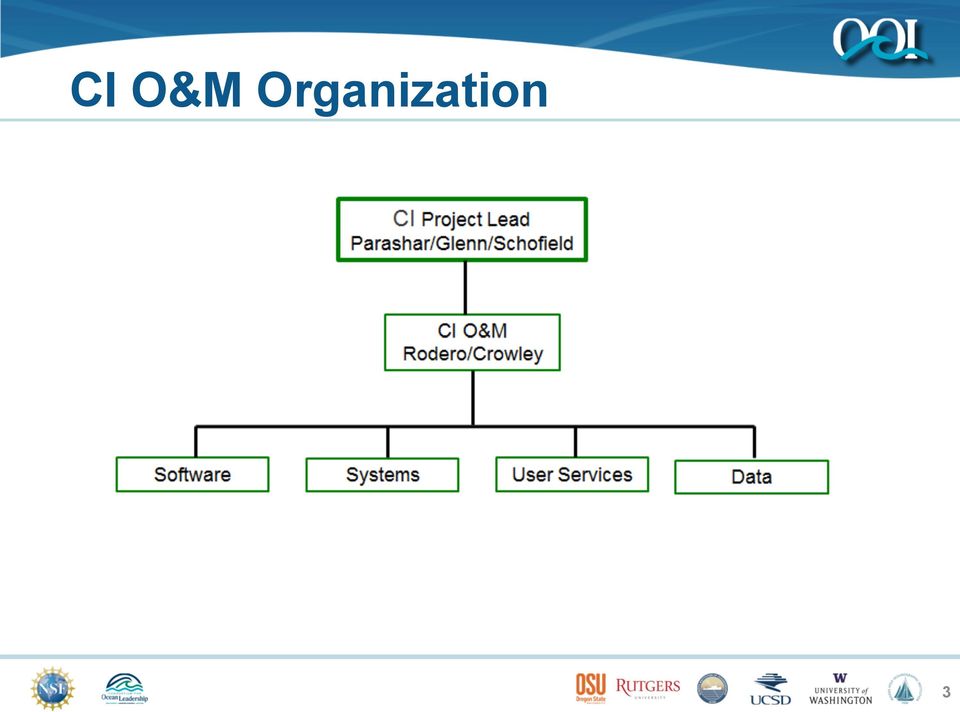
3 CI O&M Organization 3
4 Rutgers CI Structure in O&M 4

5 Rutgers CI Data Team 5
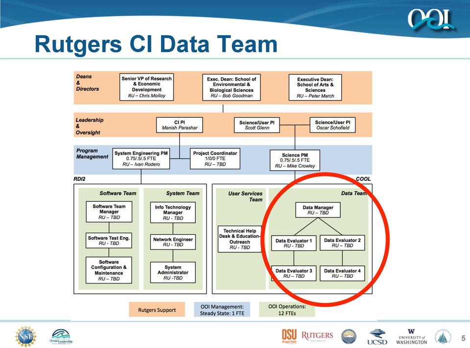
6 Data Management Team Data Manager (1) - Ph.D. + Observatory Experience - Manage the data lifecycle - Manage the data evaluators - Primary human interface for data access & feedback Data Evaluators (4) - Senior level - Ph.D. or MS + Experience - Regular level MS or BS + Experience - Monitor automated Quality Control - Regular and directed human-in-the-loop QC - Designated for Global, Cabled, Endurance & Pioneer 6

7 Data Manager - Hired 7

8 Deployed Scope of OOI (over 800 instruments distributed over all moorings, benthic packages, seafloor nodes, gliders and AUVs) Global Arrays Subsystems Components Instruments Service Frequency Global Arrays Station Papa 1 Subsurface Hybrid Profiler Mooring 12 Yearly 2 Flanking Moorings 32 3 Gliders 9 Irminger Sea 1 Surface Mooring 23 Yearly 1 Subsurface Hybrid Profiler Mooring 12 2 Flanking Moorings 32 3 Gliders 9 Southern Ocean 1 Surface Mooring 23 Yearly 1 Subsurface Hybrid Profiler 12 2 Flanking Moorings 32 3 Gliders 9 Argentine Basin 1 Surface Mooring 23 Yearly 1 Subsurface Hybrid Profiler 12 2 Flanking Moorings 32 3 Gliders 9 Cabled Arrays Subsystems Components Instruments Service Frequency Regional Scale Nodes Hydrate Ridge Seafloor: Primary and Secondary 16 Yearly Profiler Winched 10 Profiler Wire crawler 5 Midwater Platform@ 200m 8 Bottom Instrument Package 6 Axial Seamount Seafloor: Primary and Secondary 26 Yearly Profiler Winched 10 Profiler Wire crawler 5 Midwater 200m 8 Bottom Instrument Package 6 Connected by 880km of seafloor cable, with 10KW power, internet connectivity between 7 primary nodes, multiple secondary nodes, and all distributed instrumentation Coastal Arrays Subsystems Components Instruments Service Frequency Coastal Arrays Pioneer 3 Surface Moorings 60 Twice a year 2 Surface-Piercing Profilers Moorings 18 5 Profiler Moorings 29 3 AUVs 18 6 Gliders 30 Endurance (Oregon Line) 3 Surface Moorings 50 Twice a year 2 Surface-Piercing Profilers Moorings 18 1 Hybrid Profiler Mooring 16 1 Benthic Experiment Package 10 1 Multi-Function Nodes 8 Endurance (Washington Line) 3 Surface Moorings 68 Twice a year 2 Surface-Piercing Profilers Moorings 18 1 Profiler Mooring 5 6 Gliders 30 Computing platforms, software applications, storage, and high speed network equipment Cyber Points of Presence (CyberPoPs) Acquisition Points Distribution Points Integrated Observatory Network OOI Net Hardware / Software Redundant computing environment Cyberinfrastructure Extensive details about each component can be found on the OOI website ( 8

9 Data Flow Example: Pioneer Profiler Profiler Controller Inductive Modem ADCPS/T Ocean WHOI Instrument MOPAK RTE Inductive Modem CTDPF DOFST FLORT PARAD VEL3D Platform Controller Telemetry Iridium OMC Platform Shore Server rsync OMC Data Server Rutgers GUI User rsync from WHOI RU Data Ingest Server Dataset Agent/ Driver uframe Database Data Product Algorithm External Database (ERDAPP) User 9

10 Types of Data Acquired Telemetered (Global, Pioneer, Endurance Arrays) Near real time dataset transmitted to OMC via satellite. A smaller subset of the full recovered dataset. Streaming (Cabled, Endurance Arrays) Real time science and engineering data sent to OMS via cable. Nearly complete subset of the full recovered dataset. Recovered Full dataset (science & engineering) brought back to shore via the recovery vessel. Calibration Dedicated data collected on shore or at sea by manufacturers or Marine Operators to calibrate at-sea sensors. Shipboard Environmental data collected by the ships in normal operations. Metadata 10

11 Data Products Produced Level 0 (L0) Raw sensor data acquired by the Marine Operators Level 1 (L1) Calibrated data in science units: (a) Derived from L0 data (e.g. Conductivity, Temperature & Depth from a CTD), or (b) Delivered through vendor software (e.g. Glider data) Level 2 (L2) Calibrated data in science units derived from multiple L1 products (e.g. Salinity & Density from a CTD) 11

12 OOI Data Quality ConOps Sensor Data Linked Via uframe OMC/OMS uframe Calibration Files Ship Metadata Data visualization Data QA/QC Science User, Educator/ student Marine IOs OOI-net Ux/Ui Data Qa/Qc WHOI, Scripps Raytheon, ASA, ASA, Rutgers, OSU, UW Rutgers Rutgers SMEs 12

13 Data Quality Assurance & Control Quality Assurance Activities by Marine Operators Factory Calibrations, Burn in, Deployment, Recovery Feedback from Data Management Team Automated Quality Control Algorithms Global Range, Local Range, Stuck Sensor, Spike, Gradient, Trend Generate & accumulate automated Quality Control flags Quick Look Data Plots Human in the loop flagging (red, yellow, green & events) Routine workflow with standardized GUIs for Data Evaluators Time Series, Profiles, T-S, Multiple Sensors on same platform Deep Dive Data Investigations Human in the loop Directed workflow by Data Manager with input from community Recovered vs Telemetered, Comparisons w/ Calibration Data, Vicarious calibration comparisons, Climatologies/Models, etc. 13

14 User Interface Categories Status User Interface The Status UI will rely-upon engineering, instrument, status log and asset information data that will be made available by the uframe system. Science User Interface Will contain tools to perform basic analysis of the data. Some of the tools are: GIS mapping of marine assets, visualization of time-series data, trend-analysis tools. Asset Management User Interface Front-end for the asset management database. Allows users to view and modify the data within the asset management system. Also provides APIs to allow scripted updates. Command and Control User Interface Front-end for the monitoring of marine assets and infrastructure. Provides capability of sending commands to the OOI cabled infrastructure specific to the Cabled Array needs 14

15 Visualization Tools for Data QC Close iterative feedback between ASA visualization team and Rutgers data team Time series Depth profiles Parameter-parameter plots X-Y-Z plots 15

16 QC Test Comparisons - ARGO 16

17 Pioneer Array Science How exchanges between a broad shelf with the a deep ocean that is bounded by an energetic western boundary system structure physics, chemistry, and biology of continental shelves Observing**Requirements:* Nested*simultaneous*observa6ons* resolving*short*6me*scales*and* mul6ple*spa6al*scales,*data*from* air<sea*interface*to*sea*floor,* mul6disciplinary*sensor*suites,*real< 6me*data,*high*resolu6on*adap6ve* sampling* Engineering*Drivers:** High*turbulence*resul6ng*in*high* frequency*heterogeneity*in*space/ 6me,*high*rates*of*bio<fouling,* human*presence,*rapid*response* cabaili6es* 17

18 Comparisons to Other Data Streams Met data showing storm responsible for surface cooling First OOI data through uframe - Glider temperature profiles 18

19 Comparisons to Other Data Streams Warm/salty anomalies observed in glider data Satellite SST showing warm core rings responsible for warming 19

20 Vicarious Calibration Opportunities Two OOI Gliders fly by the OOI Wire Following Profiler inshore of the warm core ring observed in the SST Profiling Mooring Central Offshore Glider 002 Glider

21 Data Quality Confidence Building Efforts to engage the external community Engender excitement and ownership of OOI data. Initial focus on Pioneer Array Mini-workshop Expandable to core OOI sensors at other arrays Ocean Observing Science Committee plans for data evaluation workshop Ad-hoc committee of experts formed (based on disciplinary expertise) Intense Data Evaluation at Rutgers Datasets shared with Mini- Workshop participants Mini-Workshop with OOSC, External Experts, Marine IO PSs and CI team. Wider Open community Pioneer data workshop October 2014 November 2014 December 2014 January 2015 February 2015 March 2015 April 2015 May
22 Pioneer Array Mini-Workshop 1.5 Day Mini-Workshop At Rutgers on Feb Overall Goals: (1) Sensors Review QC procedures for first 4 sensor systems (2) User Information Define mechanisms for outreach to user community (3) Community Pioneer Data Workshop Decisions on timing, goals, agenda & constraints 22
23 Mini-Workshop Feedback Matrix Provide feedback on the matrix of 3 data QC activities being applied to 4 types of sensors deployed on Gliders and Wire Following Profilers at Pioneer Automated Algorithms CTD ADCP Ecopuck & PAR Oxygen Quick Look Plots Deep Dive Investigations Based on the Pioneer data viewed during the feedback matrix exercise, provide a summary assessment of the data at this stage and recommendations for the future 23
24 Mini-Workshop Participants OOSC Members: Larry Atkinson, Emmanuel Boss, Mary Jo Richardson, Steve DiMarco, Rouying He, Suzanne Carbotte, Raphael Kudela & Annette DeSilva External Experts: (a) Wendell Brown (U Mass) - CTDs (b) Libe Washburn (UCSB) ADCPs (c) Heidi Sosik (WHOI) Puck & PAR (Optical) (d) Mark Moline (U Del) - Oxygen Marine Operator Project Scientists (PS): (a) Al Plueddemann (Pioneer), in person (b) Jack Barth (Endurance), Deb Kelley (Cabled) & Bob Weller (Global), via webex Rutgers CI Data Management Team, OL & NSF 24
25 Future Mini/Community Workshops Targeting 2-3 Community Workshops in February Pioneer Mini-Workshop leads to the Pioneer Community Workshop After Pioneer Mini-Workshop, begin work on potential Mini-Workshops with Deb Kelley on Cabled Array, Bob Weller on Global, Jack Barth on Endurance. Endurance is a natural extension of the Pioneer & Cabled Array workshops, and will benefit from that experience. Global Array has already held a successful Irminger Sea workshop to engender international community involvement. 25
26 Pioneer Data Evaluation Philosophy Gather a small group of experts to evaluate the scientific quality of a Pioneer data subset that passes through uframe. Generate recommendations in time to help prioritize remaining construction & transition. Pioneer data subset through uframe release 1A of 5 planned releases is the first opportunity. Data streams may not be 100% bug-free, just sufficiently bug-free to enable an initial scientific evaluation. 26
27 Pioneer Data Evaluation Process Quick reminder of Pioneer platform and sensor configurations. Introduce existing transition processing and visualization tools. Review existing test data that has passed through uframe release 1A as documented in existing reports. Review automated QC Algorithms and coefficient look-up table. Generate recommendations for OOI Net Transition Team 27
28 Pioneer Data Recommendations Thursday develop recommendations for: uframe core data processing algorithms GUI display screens to enable internal data evaluation and external scientific use Automated QC coefficients in look-up table Additional data investigations led by the Data Manager Feedback to Marine Operators Friday gap fill and prioritize (1,2,3). Submit. 28
Schedule of Construction. Project Management and Control
 Ocean Observatories Initiative Schedule of Construction Project Management and Control Anthony Ferlaino OOI Project Manager Science Community Workshop I Baltimore, Nov 11-12, 2009 Process Controls of a
A beginners guide to accessing Argo data. John Gould Argo Director
 A beginners guide to accessing Argo data John Gould Argo Director Argo collects salinity/temperature profiles from a sparse (average 3 x 3 spacing) array of robotic floats that populate the ice-free oceans
Data Stewardship for Mobile Platforms at Ocean Networks Canada
 DISCOVER THE OCEAN. UNDERSTAND THE PLANET. Data Stewardship for Mobile Platforms at Ocean Networks Canada Schmidt Ocean Institute 2015 Research Planning Workshop August 27, 2015 Reyna Jenkyns Ocean Networks
Coriolis data centre Coriolis-données
 direction de la technologie marine et des systèmes d'information département informatique et données marines Christine Coatanoan Loïc Petit De La Villéon March 2005 COR-DO/DTI-RAP/04-047 Coriolis data
Coriolis data-centre an in-situ data portail for operational oceanography
 Coriolis data-centre an in-situ data portail for operational oceanography Loïc Petit de la Villéon -Ifremer http://www.coriolis.eu.org codac@ifremer.fr 1 How did Coriolis start to work on operational oceanography?
Perspektiv fra en faglig ansatt
 Perspektiv fra en faglig ansatt Geir Johnsen, NTNU Strategiske partnerskap og allianser hva får vi ut av dem case NORUS Forskning Hands On Undervisning Fremtidige partnerskap og allianser SiU funded NORUS
telemetry Rene A.J. Chave, David D. Lemon, Jan Buermans ASL Environmental Sciences Inc. Victoria BC Canada rchave@aslenv.com I.
 Near real-time transmission of reduced data from a moored multi-frequency sonar by low bandwidth telemetry Rene A.J. Chave, David D. Lemon, Jan Buermans ASL Environmental Sciences Inc. Victoria BC Canada
Maintenance and Disposition. Ocean and Marine Technology Functional Files. Function Number 1800
 Maintenance and Disposition Ocean and Marine Technology Functional Files Function Number 1800 Function number 1800 deal with program related to ocean and marine technology promotion, evaluation, and information.
TROPICAL ATMOSPHERE-OCEAN (TAO) PROGRAM FINAL CRUISE REPORT TT-15-01. Area: Equatorial Pacific: 8 N 95 W to 8 S 95 W and 8 S 110 W to 8 N 110 W
 PROGRAM FINAL CRUISE REPORT TT-15-01. Area: Equatorial Pacific: 8 N 95 W to 8 S 95 W and 8 S 110 W to 8 N 110 W") TROPICAL ATMOSPHERE-OCEAN (TAO) PROGRAM FINAL CRUISE REPORT TT-15-01 Area: Equatorial Pacific: 8 N 95 W to 8 S 95 W and 8 S 110 W to 8 N 110 W Itinerary: TT-15-01 DEP April 6, 2015, San Diego, CA ARR May
TROPICAL ATMOSPHERE-OCEAN (TAO) PROGRAM FINAL CRUISE REPORT TT-15-01 Area: Equatorial Pacific: 8 N 95 W to 8 S 95 W and 8 S 110 W to 8 N 110 W Itinerary: TT-15-01 DEP April 6, 2015, San Diego, CA ARR May
MI oceanographic data
 Marine Institute Oceanographic Data SMARTSkills 2013 Postgraduate Workshop Galway, Oct 2013 Kieran Lyons (kieran.lyons@marine.ie) MI oceanographic data Measured Operational metocean time series (weather
CTD Oceanographic Tags
 CTD Oceanographic Tags The first telemetry tag that links a marine mammal s behavior with its physical environment. Features: Oceanographic quality temperature & salinity profiles Detailed individual dive
Data Management Activities. Bob Keeley OOPC- 9 Southampton, Jun, 2004
 Data Management Activities Bob Keeley OOPC- 9 Southampton, Jun, 2004 OIT Project Issues These include: effective telecommunication needs for agreed standards and protocols provision for innovative data
SYSTEMS ENGINEERING MANAGEMENT PLAN
 SYSTEMS ENGINEERING MANAGEMENT PLAN Version 3-12-P Document Control Number 1100-00000 2010-07-27 Consortium for Ocean Leadership 1201 New York Ave NW, 4 th Floor, Washington DC 20005 www.oceanleadership.org
Research-based Educational Field Studies Using New Sensors for Mapping of Water Surface, Column and Sea-floor
 Research-based Educational Field Studies Using New Sensors for Mapping of Water Surface, Column and Sea-floor Jørgen Berge, Tove Gabrielsen, Ole-Jørgen Lønne UNIS Mark Moline and Christopher Clark California
A.1 Sensor Calibration Considerations
 Wind Speed and Direction Appendix A. Quality Assurance A major pre-requisite for establishing quality control standards for wind measurements is a strong quality assurance program. Remember the mantra
Coriolis data-centre an in-situ data portail for operational oceanography. http://www.coriolis.eu.org codac@ifremer.fr
 Coriolis data-centre an in-situ data portail for operational oceanography Ingrid Puillat on behalf of L. Petit de la Villeon & G. Maudire IFREMER http://www.coriolis.eu.org codac@ifremer.fr 1 How did Coriolis
Adaptive Sampling and the Autonomous Ocean Sampling Network: Bringing Data Together With Skill
 Adaptive Sampling and the Autonomous Ocean Sampling Network: Bringing Data Together With Skill Lev Shulman, University of New Orleans Mentors: Paul Chandler, Jim Bellingham, Hans Thomas Summer 2003 Keywords:
PROTOCOLS AND PROCEDURES FOR OOI DATA PRODUCTS: QA, QC, CALIBRATION, PHYSICAL SAMPLES
 PROTOCOLS AND PROCEDURES FOR OOI DATA PRODUCTS: QA, QC, CALIBRATION, PHYSICAL SAMPLES Version 1-22 Document Control Number 1102-00300 2013-01-15 Consortium for Ocean Leadership 1201 New York Ave NW, 4
Joint European Research Infrastructure network for Coastal Observatories
 Joint European Research Infrastructure network for Coastal Observatories Delayed Mode Data Management Handbook V1 - D5.1 Grant Agreement n 262584 Project Acronym: JERICO Project Title: Towards a Joint
Application of Subsea Wireless Technology to Environmental Monitoring
 Application of Subsea Wireless Technology to Environmental Monitoring Amanda Collins Marketing, WFS Technologies Edinburgh, UK amanda@wfs-tech.com Abstract This paper will look at how wireless technology
OCEANOGRAPHIE OPERATIONNELLE DU LARGE A LA COTE
 OCEANOGRAPHIE OPERATIONNELLE DU LARGE A LA COTE LES OUTILS ET LES OBSERVATOIRES DE L OCEAN HAUTURIER ET CÔTIER EPROJECTS (directives, policies, communications) EURO ARGO (ESFRI) Oceanic modelling Marine
A Project to Create Bias-Corrected Marine Climate Observations from ICOADS
 A Project to Create Bias-Corrected Marine Climate Observations from ICOADS Shawn R. Smith 1, Mark A. Bourassa 1, Scott Woodruff 2, Steve Worley 3, Elizabeth Kent 4, Simon Josey 4, Nick Rayner 5, and Richard
Sea Mammal Research Unit. GPS Phone Tags. www.smru.st-and.ac.uk. Introduction. University of St Andrews. e-mail: telemetry@st-and.ac.
 GPS Phone Tags A major advance in marine mammal telemetry, featuring: GPS quality locations Detailed individual dive and haulout data Efficient and cheap data relay via mobile phone GSM Introduction The
The BEAMS Program College of Charleston & University of Washington
 The BEAMS Program College of Charleston & University of Washington Development of the Marine Survey Workforce Leslie R. Sautter, Ph.D. Scott Harris, Ph.D. Dept. of Geology and Environmental Geosciences
DEVELOPMENT AND FIELD TRIAL OF OER'S MOBILE TELEPRESENCE UNIT ABOARD THE R/V ROGER REVELLE
 DEVELOPMENT AND FIELD TRIAL OF OER'S MOBILE TELEPRESENCE UNIT ABOARD THE R/V ROGER REVELLE ROLAND BRIAN: CONTRACTOR, STEVE FOLEY: UCSD HSN, WEBB PINNER: NOAA OER, JOSEPH RESING: JISAO- UW/NOAA/PMEL, SHARON
ICES Guidelines for Profiling Float Data (Compiled January 2001; revised April 2006)
") ICES Guidelines for Profiling Float Data (Compiled January 2001; revised April 2006) Profiling floats are neutrally buoyant devices that periodically surface to transmit data to a satellite system. The
ICES Guidelines for Profiling Float Data (Compiled January 2001; revised April 2006) Profiling floats are neutrally buoyant devices that periodically surface to transmit data to a satellite system. The
SCOOP: The Future of NDBC Real-Time Data Collection and Reporting
 SCOOP: The Future of NDBC Real-Time Data Collection and Reporting National Data Buoy Center Stennis Space Center, MS James Elliott INMARTECH 2014, Corvallis Oregon Self-Contained Ocean Observations Payload
Coriolis, a French project for operational oceanography
 Coriolis, a French project for operational oceanography S Pouliquen *1,T Carval *1,L Petit de la Villéon *1, L Gourmelen *2, Y Gouriou *3 1 Ifremer Brest France 2 Shom Brest France 3 IRD Brest France Abstract
Data Management Handbook
 Data Management Handbook Last updated: December, 2002 Argo Data Management Handbook 2 TABLE OF CONTENTS 1. INTRODUCTION...4 2. GLOBAL DATA FLOW...5 3. RESPONSIBILITIES...6 3.1. NATIONAL CENTRES:...6 3.2.
Woods Hole Group, Inc. Oceanography and Measurement Systems Division INTEGRATED REAL-TIME MONITORING SYSTEM
 Woods Hole Group, Inc. INTEGRATED REAL-TIME MONITORING SYSTEM Woods Hole Group, Inc. (WHG) has developed the Integrated Real-time Monitoring System (IRMS) as a general-purpose data acquisition and telemetry
The relationships between Argo Steric Height and AVISO Sea Surface Height
 The relationships between Argo Steric Height and AVISO Sea Surface Height Phil Sutton 1 Dean Roemmich 2 1 National Institute of Water and Atmospheric Research, New Zealand 2 Scripps Institution of Oceanography,
The Integration of Hydrographic and Oceanographic Data in a Marine Geographic Information System U.S. Hydro 2015
 The Integration of Hydrographic and Oceanographic Data in a Marine Geographic Information System U.S. Hydro 2015 Karen Hart CARIS USA Oceanography and Hydrography Defined Oceanography: The branch of Earth
BIO Argo Data Management Meeting, Liverpool 14 and 15 October 2013
 BIO Argo Data Management Meeting, Liverpool 14 and 15 October 2013 Forewords: This document summarizes the discussions and subsequent decisions taken during the ADMT14 meeting. Nevertheless, after the
ARCTICNET 2007-2008 MCLANE MOORED PROFILER DATA - QUALITY CONTROL REPORT. Jessy Barrette and Yves Gratton
 ARCTICNET 2007-2008 MCLANE MOORED PROFILER DATA - QUALITY CONTROL REPORT By Jessy Barrette and Yves Gratton INRS-Eau, Terre et Environnement 490, de la Couronne Québec, Qc Canada, G1K 9A9 June 2012 i 2012,
Okeanos Explorer has several core capabilities that are telepresence enabled which bring the experience of being at sea back to you on shore
 Welcome everyone. This is an introduction to the Collaboration Tools used by Okeanos Explorer, the Nation s only federal ship dedicated to ocean exploration. The main objective of our program is to achieve
An Automated Ocean and Weather Monitoring System for Use on Volunteer Observing Ships (VOS)
") An Automated Ocean and Weather Monitoring System for Use on Volunteer Observing Ships (VOS) Tom Houston, Geoffrey K. Morrison, Cynthia Moore and Rod G. Zika The International SeaKeepers Society 4600 Rickenbacker
An Automated Ocean and Weather Monitoring System for Use on Volunteer Observing Ships (VOS) Tom Houston, Geoffrey K. Morrison, Cynthia Moore and Rod G. Zika The International SeaKeepers Society 4600 Rickenbacker
Chapter Overview. Bathymetry. Measuring Bathymetry. Echo Sounding Record. Measuring Bathymetry. CHAPTER 3 Marine Provinces
 Chapter Overview CHAPTER 3 Marine Provinces The study of bathymetry charts ocean depths and ocean floor topography. Echo sounding and satellites are efficient bathymetric tools. Most ocean floor features
Sensor data management software, requirements and considerations. Don Henshaw H.J. Andrews Experimental Forest
 Sensor data management software, requirements and considerations Don Henshaw H.J. Andrews Experimental Forest Joint NERC Environmental Sensor Network/LTER SensorNIS Workshop, October 25-27 th, 2011 COMMON
An autonomous indicator-based ph sensor for oceanographic research and monitoring
 An autonomous indicator-based ph sensor for oceanographic research and monitoring Annual report for period Dec. 1, 2009 to Nov. 30, 2010 PI: Michael DeGrandpre, PhD Dept. of Chemistry and Biochemistry,
CAREER TRACKS PHASE 1 UCSD Information Technology Family Function and Job Function Summary
 UCSD Applications Programming Involved in the development of server / OS / desktop / mobile applications and services including researching, designing, developing specifications for designing, writing,
NASA s Big Data Challenges in Climate Science
 NASA s Big Data Challenges in Climate Science Tsengdar Lee, Ph.D. High-end Computing Program Manager NASA Headquarters Presented at IEEE Big Data 2014 Workshop October 29, 2014 1 2 7-km GEOS-5 Nature Run
André Karpištšenko, Co-Founder & Chief Scientist, Marinexplore Strata, 2014.02.11
 marineos André Karpištšenko, Co-Founder & Chief Scientist, Marinexplore Strata, 2014.02.11 The Ocean's Big Data Platform marineos: a platform for organizing, analyzing and distributing machine data marineos
Data Publication and Paradigm Mapping Solutions
 British Library Difficult Data Meeting December 3 2012 Mapping the data publication paradigm onto the operations of the British Oceanographic Data Centre Roy Lowry British Oceanographic Data Centre Summary
Operational Monitoring of Mesoscale Upper Layer Circulation Fields with Multi-Satellite Technology in the Southwestern Atlantic Ocean
 Operational Monitoring of Mesoscale Upper Layer Circulation Fields with Multi-Satellite Technology in the Southwestern Atlantic Ocean Marcio Vianna & Viviane Menezes VM Oceanica Ltda AGU Ocean Science
HFIP Web Support and Display and Diagnostic System Development
 HFIP Web Support and Display and Diagnostic System Development Paul A. Kucera, Tatiana Burek, and John Halley-Gotway NCAR/Research Applications Laboratory HFIP Annual Meeting Miami, FL 18 November 2015
Environmental monitoring, maritime safety and security: a convergence
 NURC - Partnering for Maritime Innovation Environmental monitoring, maritime safety and security: a convergence VISO workshop, 11-12 June 2009 Tromsø, Norway Dr. M. Rixen rixen@nurc.nato.int Deep sea observatories:
Principles and Practices of Data Integration
 Data Integration Data integration is the process of combining data of different themes, content, scale or spatial extent, projections, acquisition methods, formats, schema, or even levels of uncertainty,
NNMREC and the Pacific Marine Energy Center
 Pacific Marine Energy Center Belinda Batten Director, Northwest National Marine Renewable Energy Center Outline Wave Energy and Oregon Overview of NNMREC and mission Research and Education Testing Scaled
Use Data Budgets to Manage Large Acoustic Datasets
 Use Data Budgets to Manage Large Acoustic Datasets Introduction Efforts to understand the health of the ocean have increased significantly in the recent past. These efforts involve among other things,
Open Source DataTurbine Initiative. Tony Fountain, Peter Shin, Sameer Tilak
 Open Source DataTurbine Initiative Tony Fountain, Peter Shin, Sameer Tilak Outline OSDT Android Sensor Pod OSDT SI2 Sensor-Rocks Large-scale Personalized Mobile Sensing Systems OSDT Android Sensor Pod
Wikibon Storage Projections to an All-flash Datacenter in 2016
 Wikibon.com - http://wikibon.com Wikibon Storage Projections to an All-flash Datacenter in 2016 by David Floyer - 1 June 2015 http://wikibon.com/wikibon-storage-projections-to-an-all-flash-datacenter-in-2016/
Expansion of metadata management, visualization and data processing functionality of OBIS-SEAMAP for passive acoustic monitoring data
 Expansion of metadata management, visualization and data processing functionality of OBIS-SEAMAP for passive acoustic monitoring data Dr. Patrick N. Halpin Duke University Box 90328 Durham, NC 27708-0328
IceCube Project Monthly Report July 2007
 IceCube Project Monthly Report July 2007 Accomplishments The Data Acquisition (DAQ) software processed 1.50 billion events during 2.69 million live seconds in the month of July. The DAQ uptime percentage
DRAFT STANDARD FORM A APPLICATION FOR CONSENT TO CONDUCT MARINE SCIENTIFIC RESEARCH
 Feedback Logout User: Elizabeth Brenner Role: Platform Operator My Profile Reporting Foreign EEZ: CAREER: A functional genomic understanding of microbial s Application Attachments Authorizations Action
UNITED KINGDOM CONTRIBUTION TO ARGO
 UNITED KINGDOM CONTRIBUTION TO ARGO REPORT FOR ARGO SCIENCE TEAM 6 TH MEETING, MARCH 2004 The UK's contribution to Argo is being funded by the Department of the Environment, Food and Rural Affairs (Defra),
Real-time Ocean Forecasting Needs at NCEP National Weather Service
 Real-time Ocean Forecasting Needs at NCEP National Weather Service D.B. Rao NCEP Environmental Modeling Center December, 2005 HYCOM Annual Meeting, Miami, FL COMMERCE ENVIRONMENT STATE/LOCAL PLANNING HEALTH
A standards-based open source processing chain for ocean modeling in the GEOSS Architecture Implementation Pilot Phase 8 (AIP-8)
") NATO Science & Technology Organization Centre for Maritime Research and Experimentation (STO-CMRE) Viale San Bartolomeo, 400 19126 La Spezia, Italy A standards-based open source processing chain for ocean
NATO Science & Technology Organization Centre for Maritime Research and Experimentation (STO-CMRE) Viale San Bartolomeo, 400 19126 La Spezia, Italy A standards-based open source processing chain for ocean
R2R Shipboard Sampling Event Logger
 R2R Shipboard Sampling Event Logger Andy Maffei, Laura Stolp, Cyndy Chandler, Cindy Sellers Rolling Deck to Repository Project Woods Hole Oceanographic Institution 12 February 2013 RVTEC 2012 Meeting Lamont
It Takes a Village to Raise a Machine Learning Model. Lucian Lita @datariver
 It Takes a Village to Raise a Machine Learning Model Lucian Lita It Takes a Village to Raise a Machine Learning Model Lucian Lita Algorithms Data Big Data Sheep @bigdatasheep n 5yr more data is better
SCICEX boat-to-archive route map and data management template Biological and Chemical Samples
 SCICEX boat-to-archive route map and data management template Biological and Chemical Samples R. Sambrotto & B. Smethie SCICEX SAC Feb. 14-15, 2013 SCICEX data management can be thought of in four parts:
AOSN II System Goals and Performance Metrics R. Davis, J. Bellingham, P. Chandler, F. Chavez, N. Leoanard, A. Robinson (revised 11 May 2003)
") AOSN II System Goals and Performance Metrics R. Davis, J. Bellingham, P. Chandler, F. Chavez, N. Leoanard, A. Robinson (revised 11 May 2003) The 2003 AOSN II field program depends on coordinated activities
AOSN II System Goals and Performance Metrics R. Davis, J. Bellingham, P. Chandler, F. Chavez, N. Leoanard, A. Robinson (revised 11 May 2003) The 2003 AOSN II field program depends on coordinated activities
Present Status of Coastal Environmental Monitoring in Korean Waters. Using Remote Sensing Data
 Present Status of Coastal Environmental Monitoring in Korean Waters Using Remote Sensing Data Sang-Woo Kim, Young-Sang Suh National Fisheries Research & Development Institute #408-1, Shirang-ri, Gijang-up,
The Curious Case of Database Deduplication. PRESENTATION TITLE GOES HERE Gurmeet Goindi Oracle
 The Curious Case of Database Deduplication PRESENTATION TITLE GOES HERE Gurmeet Goindi Oracle Agenda Introduction Deduplication Databases and Deduplication All Flash Arrays and Deduplication 2 Quick Show
Echtzeittesten mit MathWorks leicht gemacht Simulink Real-Time Tobias Kuschmider Applikationsingenieur
 Echtzeittesten mit MathWorks leicht gemacht Simulink Real-Time Tobias Kuschmider Applikationsingenieur 2015 The MathWorks, Inc. 1 Model-Based Design Continuous Verification and Validation Requirements
Developing Fleet and Asset Tracking Solutions with Web Maps
 Developing Fleet and Asset Tracking Solutions with Web Maps Introduction Many organizations have mobile field staff that perform business processes away from the office which include sales, service, maintenance,
Instrumentation for Monitoring around Marine Renewable Energy Devices
 Instrumentation for Monitoring around Marine Renewable Energy Devices 1 Introduction As marine renewable energy has developed, a set of consistent challenges has emerged following attempts to understand
Report for the North Atlantic Regional Data Center Meeting 25-26 October 2005 Ifremer Headquarters Issy Les Moulineaux
 1/7 Report for the North Atlantic Regional Data Center Meeting 25-26 October 2005 Ifremer Headquarters Issy Les Moulineaux I. Presentation of Argo Data Management Network and Role of the Regional Data
Application of Technology to Create an Integrated, Multidisciplinary Approach to Safe and Secure Ports
 2005 SRI International SRI International Company Proprietary Application of Technology to Create an Integrated, Multidisciplinary Approach to Safe and Secure Ports Presented to: 10 th Annual Harbor Safety
The PACS Software System. (A high level overview) Prepared by : E. Wieprecht, J.Schreiber, U.Klaas November,5 2007 Issue 1.
 Prepared by : E. Wieprecht, J.Schreiber, U.Klaas November,5 2007 Issue 1.") The PACS Software System (A high level overview) Prepared by : E. Wieprecht, J.Schreiber, U.Klaas November,5 2007 Issue 1.0 PICC-ME-DS-003 1. Introduction The PCSS, the PACS ICC Software System, is the
The PACS Software System (A high level overview) Prepared by : E. Wieprecht, J.Schreiber, U.Klaas November,5 2007 Issue 1.0 PICC-ME-DS-003 1. Introduction The PCSS, the PACS ICC Software System, is the
Gulf of Mexico JENNIFER PATTERSON. SonTek/YSI, San Diego, CA. Tellus Applied Sciences, Williamsburg, VA. I. Introduction
 A Field Evaluation of the CastAway CTD at the Deepwater Horizon Oil Spill site in the Gulf of Mexico JENNIFER PATTERSON SonTek/YSI, San Diego, CA MARK BUSHNELL AND MANUEL HAENGGI Tellus Applied Sciences,
Case study: End-to-end data centre infrastructure management
 Case study: End-to-end data centre infrastructure management Situation: A leading public sector organisation suspected that their air conditioning units were not cooling the data centre efficiently. Consequently,
National Data Buoy Center Cooperative Relations
 National Data Buoy Center Cooperative Relations Presentation For NGI Annual Conference May 23, 2012 Landry Bernard National Data Buoy Center Operational Mission To provide a real-time, end-to-end capability
PROJECT EXECUTION PLAN
 PROJECT EXECUTION PLAN November 2007 DRAFT v2.0 Consortium for Ocean Leadership 1201 New York Avenue NW, Fourth Floor, Washington, D.C. 20005 www.joiscience.org Table of Contents Executive Summary. iv
Data Data Everywhere, We are now in the Big Data era
 Data Data Everywhere, We are now in the Big Data era Mike Liddell 13 th March 2014 UUVs @ OI 2014 Contents Menu Background Big Data What is Generating our Big Data Physical Management of Big Data Optimisation
Solution Brief Availability and Recovery Options: Microsoft Exchange Solutions on VMware
 Introduction By leveraging the inherent benefits of a virtualization based platform, a Microsoft Exchange Server 2007 deployment on VMware Infrastructure 3 offers a variety of availability and recovery
Recent updates and discoveries (unplanned data sources) in the SW06 data
 in the SW06 data") Recent updates and discoveries (unplanned data sources) in the SW06 data Arthur Newhall, Ying-Tsong Lin, Jim Lynch, Tim Duda Reminder on data and availability Studies from unplanned data sources SW06 website
Recent updates and discoveries (unplanned data sources) in the SW06 data Arthur Newhall, Ying-Tsong Lin, Jim Lynch, Tim Duda Reminder on data and availability Studies from unplanned data sources SW06 website
At the bottom of the screen you will also see some of our sister brands, all of which can also plug in to the Storm data logger.
 This presentation will discuss how the challenges of water quality monitoring and realtime data collection can be addressed with new technology. We ll focus on the EXO sonde platform from YSI and the Storm
 Performance and Load Testing For ArcGIS based systems Ian Sims and John Meza OVERVIEW What is Performance and Load Testing What is the objective Acceptance Testing Ongoing Development Areyoutheclient Want
Université de la Médite TRANSMED: low cost thermosalinometers in the Mediterranean
 www.ciesm.org TRANSMED: a (future) network of low cost thermosalinometers in the Mediterranean I. TAUPIER LETAGE, G. ROUGIER, A. MONTIES and T. FABIANI CNRS/UNIVERSITÉ DE LA MÉDITERRANÉE ANTENNEDETOULON
How Efficient Is Your Hybrid?
 How Efficient Is Your Hybrid? Legal and Regulatory Consequences of Deploying Undersea Telecommunications Cables with Additional Energy- or Scientific Research-Related Functions Kent Bressie 13 April 2011
Permanent Reservoir Monitoring (PRM) System Installation: The Installers Perspective
 System Installation: The Installers Perspective") Permanent Reservoir Monitoring (PRM) System Installation: The Installers Perspective Introduction Global Marine Systems Limited (Global Marine) has a vast wealth of knowledge in designing planning and
Permanent Reservoir Monitoring (PRM) System Installation: The Installers Perspective Introduction Global Marine Systems Limited (Global Marine) has a vast wealth of knowledge in designing planning and
http://bco-dmo.org Go to: http://usjgofs.whoi.edu/jg/dir/jgofs/ URL: http://usjgofs.whoi.edu/jg/serv/jgofs/arabian/inventory.html0
 http://bco-dmo.org DATA ACCESS TUTORIAL 2012 OCB PI Summer Workshop Data access: catalog browse scenario 1: you are a former US JGOFS or US GLOBEC researcher, and you know what data you are looking for
Securing the future of decom
 R E Q U I R E D R E A D I N G F O R T H E G L O B A L O I L & G A S I N D U S T R Y S I N C E 1 9 7 5 AUGUST 2011 Deep thinking on the Latin American beat Floating production tales of the unexpected OFFSHORE
The MONGOOS Data portal EMODNET ROOS meeting, Brussels, 18 November 2013
 The MONGOOS Data portal EMODNET ROOS meeting, Brussels, 18 November 2013 Leonidas Perivoliotis Hellenic Center for Marine Research, Greece The MONGOOS Data Portal Collects and process data from Insitu
Quality Assurance for Hydrometric Network Data as a Basis for Integrated River Basin Management
 Quality Assurance for Hydrometric Network Data as a Basis for Integrated River Basin Management FRANK SCHLAEGER 1, MICHAEL NATSCHKE 1 & DANIEL WITHAM 2 1 Kisters AG, Charlottenburger Allee 5, 52068 Aachen,
Cruise Report. OSU R/V Oceanus OC1405B. Cascadia Initiative Leg 2 May 28 to June 1 Newport, OR Newport OR. Matt Fowler Chief Scientist
 Cruise Report OSU R/V Oceanus OC1405B Cascadia Initiative Leg 2 May 28 to June 1 Newport, OR Newport OR Matt Fowler Chief Scientist Captain and Crew: R/V Oceanus: Captain: Jeff Crews Chief Engineer: Jonathan
Cable Laying and Repair - Cable Ship Operations
 http://oceanexplorer.noaa.gov/explorations/03edge/background/sargassum/sargassum.html Cable Laying and Repair - Cable Ship Operations Dr. R.J. Rapp, Director, Industry & Marine Liaison, TE SubCom Submarine
North-Atlantic Regional Data Center. Virginie Thierry E. Autret, F. Gaillard, Y.Gouriou, S. Pouliquen
 North-Atlantic Regional Data Center Virginie Thierry E. Autret, F. Gaillard, Y.Gouriou, S. Pouliquen Overview Introduction: A North-Atlantic DAC Part I - Analysis of T and S at Coriolis: a contribution
BIOLOGICAL MONITORING WITH THE WESTERN CANADIAN ODAS MARINE BUOY NETWORK
 BIOLOGICAL MONITORING WITH THE WESTERN CANADIAN ODAS MARINE BUOY NETWORK Jim Gower, Angelica Peña and Ann Gargett Institute of Ocean Sciences, P.O. Box 6, Sidney, BC, V8L 4B2 Tel: 2 363-68, Fax: 363-6746,
OCEANOGRAPHIC DECISION SUPPORT SYSTEM (ODSS) A TOOL TO IMPROVE EFFICIENCY OF BIOLOGICAL OCEAN STUDY
 A TOOL TO IMPROVE EFFICIENCY OF BIOLOGICAL OCEAN STUDY") OCEANOGRAPHIC DECISION SUPPORT SYSTEM (ODSS) A TOOL TO IMPROVE EFFICIENCY OF BIOLOGICAL OCEAN STUDY Maughan, T. G., MBARI, Moss Landing, USA, tm@mbari.org Rajan, K.., MBARI, Moss Landing, USA, kanna@mbari.org
OCEANOGRAPHIC DECISION SUPPORT SYSTEM (ODSS) A TOOL TO IMPROVE EFFICIENCY OF BIOLOGICAL OCEAN STUDY Maughan, T. G., MBARI, Moss Landing, USA, tm@mbari.org Rajan, K.., MBARI, Moss Landing, USA, kanna@mbari.org
Directorate for Geosciences
 NSF Regional Grants Conference Salt Lake City, Utah Directorate for Geosciences Sonia Esperança, Ph.D. Division of Earth Sciences sesperan@nsf.gov The Mission of the Directorate for Geosciences Support
The Role of Environmental Monitoring and Data Management in Supporting Science to Inform Decision Making: A Case Study
 The Role of Environmental Monitoring and Data Management in Supporting Science to Inform Decision Making: A Case Study Presented by: Dwayne E. Porter Arnold School of Public Health and Baruch Institute
for Oil & Gas Industry
 Wipro s Upstream Storage Solution for Oil & Gas Industry 1 www.wipro.com/industryresearch TABLE OF CONTENTS Executive summary 3 Business Appreciation of Upstream Storage Challenges...4 Wipro s Upstream
EyasSAT: A Classroom Nanosatellite for Teaching Space Systems Engineering. EyasSAT 1
 : A Classroom Nanosatellite for Teaching Space Systems Engineering 1 Introduction The Need The Solution Background System Architecture Applications Conclusions Outline 2 The Need Space Systems Engineering
Microsoft s Open CloudServer
 Microsoft s Open CloudServer Page 1 Microsoft s Open CloudServer How is our cloud infrastructure server design different from traditional IT servers? It begins with scale. From the number of customers
Baltic Marine Environment Protection Commission
 Baltic Marine Environment Protection Commission Helsinki Commission Helsinki, Finland, 3-4 March 2015 HELCOM 36-2015 Document title Special Report from a Cruise - Great Inflow to the Baltic Sea Code 6-1
Request for Quote: Marine Vessel May 16, 2014
 RFQ: Marine Vessel Request for Quote: Marine Vessel May 16, 2014 1.0 INTRODUCTION Industrial Economics, Incorporated (IEc) is seeking a qualified subcontractor(s) to provide an oceangoing vessel to support
Advanced Image Management using the Mosaic Dataset
 Esri International User Conference San Diego, California Technical Workshops July 25, 2012 Advanced Image Management using the Mosaic Dataset Vinay Viswambharan, Mike Muller Agenda ArcGIS Image Management
UK Argo Data Centre and the Southern Ocean Regional Data Centre (SORDAC)
") UK Argo Data Centre and the Southern Ocean Regional Data Centre (SORDAC) Trevor Guymer Chair, UK Argo Expert Group & Head, UK Inter-Agency Committee on Marine Science & Technology Information provided
UK Argo Data Centre and the Southern Ocean Regional Data Centre (SORDAC) Trevor Guymer Chair, UK Argo Expert Group & Head, UK Inter-Agency Committee on Marine Science & Technology Information provided
The Arctic Observing Network and its Data Management Challenges Florence Fetterer (NSIDC/CIRES/CU), James A. Moore (NCAR/EOL), and the CADIS team
, James A. Moore (NCAR/EOL), and the CADIS team") The Arctic Observing Network and its Data Management Challenges Florence Fetterer (NSIDC/CIRES/CU), James A. Moore (NCAR/EOL), and the CADIS team Photo courtesy Andrew Mahoney NSF Vision What is AON? a
The Arctic Observing Network and its Data Management Challenges Florence Fetterer (NSIDC/CIRES/CU), James A. Moore (NCAR/EOL), and the CADIS team Photo courtesy Andrew Mahoney NSF Vision What is AON? a