A little on Marine Core Services
|
|
|
- Samson York
- 7 years ago
- Views:
Transcription

1 A little on Marine Core Services
2 Copernicus Services -> CLOSE WATCH -> RELIABLE and UP-TO-DATE information 6 thematic areas: Land Monitoring Operational Emergency Management Operational Atmosphere Monitoring MACC - MACC2 Pre-operational (Project step) Marine Monitoring MyOcean - MyOcean2 Pre-operational (Project step) Security Development Phase Climate Change Development Phase -> All services are provided free of charge to users at the point of use.
3 MyOcean, Towards the European Copernicus Marine Service MyOcean is an EU funded R&D project (FP7) which fits into the European Earth monitoring programme COPERNICUS. Copernicus User Awareness & Training Tallinn 9/10 April 2014
 monitoring water quality, combatting oil spills, assessing environmental impact, protecting living")
4 A Copernicus Marine Service, Which benefits for the citizen? European citizens are all concerned by Environment and Security at sea. MyOcean services are useful for : reinforcing safety at sea (offshore operations, search & rescue ) monitoring water quality, combatting oil spills, assessing environmental impact, protecting living marine resources, harnessing thermal water energy delivering data for Climate Change scenarios, predicting coastal erosion ( )
5 Mission statement of the Copernicus Marine Service A unique European Marine capability and core-knowledge base Knowledge and innovation base for the maritime policies (Environment & Security) Engine for smart and sustainable growth in the European Union Scientific knowledge for addressing environmental issues.
6 Foundations of the Copernicus Marine Service GMES = Global Monitoring for Environment and Security ( former name of Copernicus)
 STRONG PARTNERSHIP WITH")
7 59 Partners, 28 countries MyOcean ( ) / MyOcean 2 ( ) STRONG PARTNERSHIP WITH EuroGOOS

 Intermediate Users Downstream Service APPLICATIONS")
8 SERVICE MyOcean, How does it work? observations per day from Space and Sea marine service USER USER USER DATA DATA Production of Ocean observations, analysis SYSTEM and Forecasts (Models) Intermediate Users Downstream Service APPLICATIONS providers Public or private USER USER USER USER USER
9 We process Satellite and In Situ Observations From Space Sea Surface Topography, Sea Surface Temperature, Ice, Ocean Color Altimetry, Temperature, Color, SAR data, From the Sea (In Situ) Temperature, Salinity, Sea Level, Currents, ARGO floats, vessels data, drifting buoys, moorings,
10 We run Global and Regional 3D Models We run routinely 3D models, assimilating real time observations We cover the Global Ocean and 6 European Regions The typical grid scale is 1/12 for the global (5-7 km ) and 1/36 for regional (2-3 km) Physical Ocean data and biogeochemical data


11 MyOcean provides a core service To describe the ocean To deliver the data to users To share & inform 350 marine experts in 29 countries 46 inter-connected systems 300 technical interfaces billions of ops/day on supercomputers MyOcean web portal : a sole data Access point. A catalogue of 111 products. Inspire directive compliant A service desk providing assistance and connecting users to experts. MyOcean website Quality Monitoring Information to citizen on the MyOcean IPhone app
 Real Time (Daily/ hourly) Forecast ( 2 to 10 days) Quality indices Next major release now in")
12 A service regularly upgraded Feb2014: 111 Products in one catalogue Currents, Temperature, Salinity, Sea Level, Sea Ice extent, Biogeochemistry, Observation- and modelbased products Re-analyses ( 20 years) Real Time (Daily/ hourly) Forecast ( 2 to 10 days) Quality indices Next major release now in April (V4)
 Area 3 «MARINE AND COASTAL ENVIRONMENT» (water quality,")
 11% 32%")
13 We serve 4 Areas of Benefits 27% 30% Area 1 «MARINE SAFETY» (marine operations, oil spill drift, ship routing, defense, search & rescue, ) Area 3 «MARINE AND COASTAL ENVIRONMENT» (water quality, pollution, coastal activities, ) Area 2 «MARINE RESSOURCES» (fish stock management, ICES, FAO, ) Area 4 «CLIMATE & WEATHER FORECASTING» (climate monitoring, IPY, seasonal forecasting,..) 11% 32%

14 We serve users WW 100 countries delivered 3400 users mid-feb 2014
15 Use cases
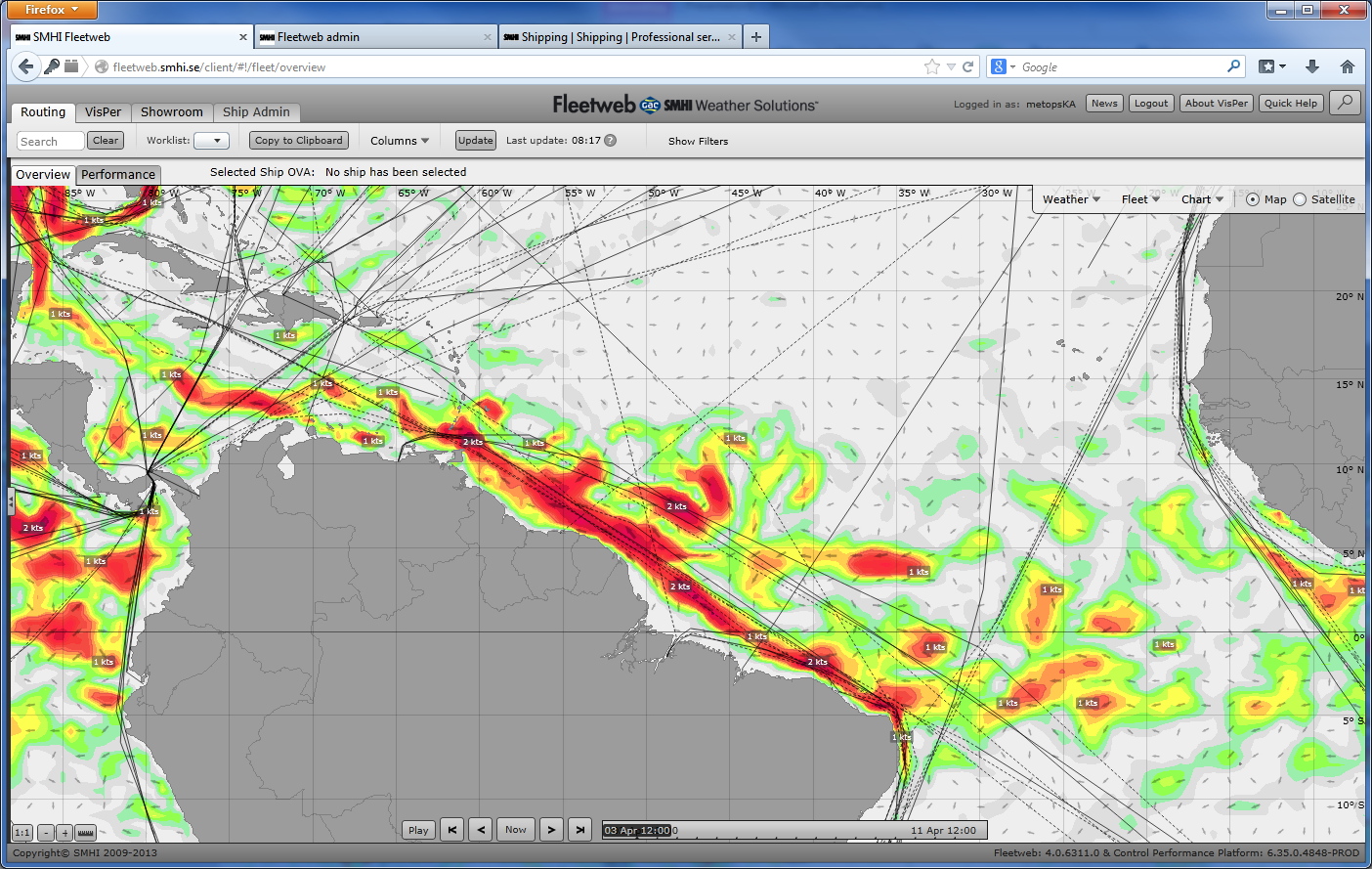
16 SMHI Onboard Routing Fleetweb helps the skipper to be proactive instead of reactive! Deviating vessel speed and fuel consumption put in relation to contracts Expected and reported vessel arrival times in relation to SMHI estimations, based on data from ship captains Estimates of potential lost sailing time and over-consumption of fuel OVA; Ongoing Voyage Analysis. By a simple click you will access all necessary information on the vessel and its current route. Here are also all communications between SMHI and the vessel are available Showroom - gives you a quick overview of the entire fleet, constantly updated About 1400 trips per month handled in Fleetweb. For approx 250 of these a post Post Voyage Analysis is done. The currents from MyOcean are used in about 300 on board systems.

17
18 Earth Observation for Polar Monitoring Created in 2005, Polar View is an international consortium providing a wide variety of earth observation poducts that monitor sea ice cover, glacier runoff, snow cover, snow melt, icebergs, river ice, and lake ice.
19 Sustainable Economic Development Optimizes transportation routes Assists with hydropower generation management Provides information to resource extraction operations Involves indigenous communities Security & Risk Mitigation Allows vessels to chart safe routes around sea ice and icebergs Guides fishing and hunting expeditions for Northern residents Helps protect offshore drilling operations Improves the efficacy of flood warning services Environmental Stewardship Monitors polar freshwater cycles Provides information to help understand and manage animal populatio and habitats Increases awareness of the impacts of climate change and adaptation a mitigation strategies
20 Iceberg Map Polar View imagery tracks ice shelf calving triggered by Japan s earthquake and tsunami Recent satellite photos from the European Space Agency show huge icebergs were created when the Japanese tsunami hit West Antarctica's Sulzberger Ice Shelf. This caused 125 sq km of ice to break off - or calve - from a shelf front that has remained stable for the past 46 years. Kartdata 2014 Google Bilder 2014 TerraMetrics Active Icebergs Currently, there are no active icebergs. In the meantime, check out what the map looked like on these days: May 30 June 5 June 10 June 22 June 28
21 ICEMAR -- a GMES Pilot Sea Ice Service for Maritime Operations Objective - establish a pilot down-stream GMES sea ice information service to improve access to existing and new ice information products to aid ships navigating near or within ice-infested waters in the European Arctic (primarily the Greenland and Barents Seas) and the Baltic Sea. Shall build on existing ice service elements including GMES services and projects, national/ regional institutional and commercial services and will be established in an open and expansible way to facilitate the easy inclusion of additional information services and coverage of new geographical regions in the future.
22 ICEMAR is developing an integrated solution to deliver sea ice information products onboard
23 POLAR ICE POLAR ICE - A new single point of entry web portal Why? Significant interest in Arctic resource development and increased demand for non-standard ice and situational awareness (e.g. new shipping lanes, year-round station-keeping) POLAR ICE s overall aim: To establish an operational end-to-end operational sea ice information service by integrating /building on existing national and European funded infrastructure and capabilities The development of new products/techniques and services (like sea ice pressure) to meet known gaps in current provision POLAR ICE will be driven by the requirements of end users operating in ice infested polar waters reducing risks for shipping and offshore operators reducing the risk of environmental damage reducing costs providing information that will also be useful for the climate change monitoring community POLAR ICE will also: Transfer products and services to the Arctic and Antarctic that are currently tested and available in the Baltic Sea Ensure all ice products are Sentinel ready Provide a full assessment of the economic sustainability and technical merit of the information products and integrated service The project team includes 14 World leading organisations in the field of satellite remote sensing applied to sea ice monitoring and forecasting; all of whom are part of the Polar View network.
24 High-Resolution model: example lprerequisite: Large-scale Arctic locean model (e.g. MyOcean) lsemi-automatic set up of local lmodel (NEMO) on small area where needed... BC from large-scale model ladapt local Seatrack Web oil drift lsystem
25 25 IBPlott use of satellite images on board icebreakers Icebreakers Ships Used operationally by the Finnish, Swedish and Estonian icebreakers Port Waypoints SW designed a implemented b VTT


26 Join the MyOcean community Register online on: Access the MyOcean Collaborative forum! Participate in the next the MyOcean Training workshop, Exeter July 2-4!!! Join us to the next MyOcean User Workshop hosted by EMSA ( the European Maritime Safety Agency ) Lisbon June 2014 Contact MyOcean2 coordinator : Pierre.bahurel@mercator-ocean.fr
27 E-AIMS Euro-Argo Improvements for the GMES/Copernicus Marine Service ( / FP7) E-AIMS aims to improve the European contribution to the international Argo observing system and to prepare the next scientific and operational challenges for in situ monitoring of the world ocean. The main objective is to prepare the evolutions of Argo floats for the next decade. MyWave ( / FP7) A pan-european concerted and integrated approach to operational wave modelling and forecasting a complement to Copernicus Marine Monitoring services The project aims to review and propose service level and coordination requirements for a pan- European wave service complementing the Copernicus Marine Environment Monitoring Service developed by MyOcean / MyOcean2, and thus allowing end users to access a complete view of the physical marine environment. SANGOMA ( / EC FP7) Stochastic Assimilation for the Next Generation Ocean Model Applications SANGOMA works on new developments in data assimilation and prepares them so that future operational systems can use state-of-the-art data-assimilation and related analysis tools. The project builds on a European network of expert teams in advanced data assimilation which will extend existing modular data assimilation systems and will allow for efficient operational testing of the latest data assimilation methods. OPEC ( / EC FP7) OPerational ECology: Ecosystem forecast products to enhance marine Copernicus applications OPEC aims to improve the quality of operational services for biogeochemical and ecological parameters and, in turn, our ability to protect the future status of European marine ecosystems.
28 CoBios ( / EC FP7) Coastal Biomass Observatory Services Using a combination of satellite images and ecological models, which describe and predict ecological processes and distributions of organisms phytoplankton, nutrients and dissolved oxygen, CoBiOS intends to monitor and predict high biomass blooms in coastal waters along Europe s Northern and Baltic shores. MAIRES ( / EC FP7) Monitoring Arctic Land and Sea Ice using Russian and European Satellites MAIRES will develop new methods for mapping of sea ice, icebergs and glaciers in the Arctic. By joint analysis of high-resolution images from European and Russian satellites obtained in the last decades, it is expected to obtain significant new knowledge about ice in the Arctic. SeaU ( / EC FP7) Multisensor Satellite Technologies for Oil Pollution Monitoring and Source Identification The overall aim of SeaU is to improve the current state-of-the-art methodology for satellite based oil spill detection and monitoring, and demonstrate through deliveries to existing and new users how these improvements can contribute to the development of a next generation sustainable downstream service. SIDARUS ( / EC FP7) Sea Ice Downstream Services for Arctic and Antarctic Users and Stakeholders Polar regions are strongly affected by climate change: temperature is increasing, sea ice is retreating during the sum and land ice decreases. SIDARUS seeks to establish a set of sea ice services for climate research, marine safety and environmental monitoring in the Arctic and Antarctic regions.
29 OSS2015 ( / EC FP7) Ocean Strategic Services 2015 The OSS2015 project aims to carry out R&D activities for the development of new and innovative marine biogeochemistry products and services. The OSS2015 products and services will be derived from a combination of satellite and in-situ data as well as biological and bio-optical models. ECOOP MarCoast MERSEA GlobColour
30 What makes Copernicus so special compared to other Earth observation programmes worldwide? Philippe Brunet: A complex set of systems which collect data from multiple sources - mainly Earth observation satellites and in sensors. Copernicus processes these data and provides reliable and up-to-date information through a set of services related to environment and security. How does Copernicus fit into the overall EU policy framework? Philippe Brunet: Copernicus will benefit a wide range of Union policies and contribute to reaching the objectives of Europe 202 will support the development of an effective European space policy which provides the tools to address some the key challenges the European Union has to face, in the areas of the environment and civil security. The programme will boost research, innovation and the development of commercial applications ( downstream services ), thanks to a full and open access to Copernicus observation data and information products. ESA: Who will benefit from the programme and how? Philippe Brunet: Main users are European policymakers and national, regional and local public authorities. They need relevant information to develop environmental legislation and policies or to take critical decisions in the event of an emergency, such as a natural disaster or a humanitarian crisis. Applications bringing socio-economic benefits to European citizens include environment protection, managem of urban areas, agriculture, forestry, fisheries, health, transport, climate change, sustainable development, civ protection and tourism. The principle of full, free and open access to data will enable innovative business initiatives of all sizes to flour and therefore will support job creation and economic growth in. Over the next three years, seven Copernicusdedicated satellites, the Sentinels, are planned to be launched. The programme must continue to meet evolvin users needs and expectations.
31 End users Neste Shipping Oy (Ship owner & operator in Northern Sea Route) Aker Arctic (Ice-going ships & construction of offshore structures) Argos Froyanes Limited (Antarctic fishing company) Greenland Ice Service International Association of Antarctica Tour Operators (IAATO) Polar Geospatial Center Wetterwelt (Maritime weather service) The International Ice Charting Working Group Arctia Shipping (Arctic Shipping Company) Australian Antarctic Division (Department of Sustainability, Environment, Population & Communities)
32 Examples of SIT chart 32
33
34 Examples (screenshots) of existing visualisation SW AMSR2 ice concentration with AMSR2 ice edge, NCEP wind barbs and drift
35 International Web Training Successful Polar View staff undertook website training on January 15, 2014 to provide high quality updates to the site. Training was taken simultaneously on two continents and deemed a success by all involved. Earth Observation for Polar Monitoring Iceberg sightseeing is a one of the tourist attractions of the province of Newfoundland and Labrador. Polar View data help tourists plan their trips into "Icegery Alley". Polar View's services make a significant contribution to the local tourism industry. In cooperation with Hospitality Newfoundland and Labrador, the Atlantic Canada Opportunities Agency (ACOA), and the Department of Tourism, Culture and Recreation for Newfoundland and Labrador, and with the help of the European Space Agency (ESA) and Canadian Space Agency (CSA), Polar View partner organisation C-CORE provides satellite data taken from Synthetic Aperture Radar (SAR) satellites to make iceberg maps that appear on the project's website, icebergfinder.com.

36 Ice Information Needs for Arctic Oil Spill Response and Mitigation Rationale Significant interest in Arctic resource development Increased demand for non-standard ice and situational awareness (e.g. new shipping lanes, year-round station-keeping) Major industry and government initiatives are currently under way to close knowledge gaps Potential for new and improved ice information from emerging technologies Stakeholders Arctic Response Technology JIP Response measures, modelling, monitoring, field trials International Oil and Gas Producer s Organization (OGP) Best practices and standardization Response organizations National and regional/territorial governments (Norway, Greenland, Canada, Baltic Sea States) Arctic Council EPPR Working Group Communities
POLAR ICE Integrated Arctic and Antarctic Sea Ice monitoring Services
 VTT TECHNICAL RESEARCH CENTRE OF FINLAND LTD Place for a photo (no lines around photo) Photo: Tapio Nyman http://www.polarice.eu/ POLAR ICE Integrated Arctic and Antarctic Sea Ice monitoring Services Robin
The Copernicus Marine Enviroment Monitoring Service
 The Copernicus Marine Enviroment Monitoring Service P.Y. Le Traon 7&8 Sep 2015 - CMEMS SE & UU Workshop, Brussels 1 CMEMS : The Copernicus Marine Environment Monitoring Service SATELLITES (S1, S3, Jason-CS)
METIER Course No. 6: Remote Sensing & Hydrosphere Helsinki 6 November 2008 Kati Tahvonen Finnish Environment Institute
 The Use of Remote Sensing, Drifting Forecasts and GIS Data in Oil Response and Pollution Monitoring METIER Course No. 6: Remote Sensing & Hydrosphere Helsinki 6 November 2008 Kati Tahvonen Finnish Environment
Therefore, this is a very important question, which encourages consideration of the current management of the resource.
 Aalisarnermut, Piniarnermut Nunalerinermullu Naalakkersuisoqarfik Department of Fisheries, Hunting and Agriculture Finn's speech to NAFMC Climate change in the North Atlantic has become a reality which
e-navigation and Geospatial Intelligence for Maritime Operations; Developing a Strategic Vision Digital Ship Athens 2014
 e-navigation and Geospatial Intelligence for Maritime Operations; Developing a Strategic Vision Digital Ship Athens 2014 Michael Rambaut for John Erik Hagen, Regional Director NCA Coordinator of IMO Correspondence
CMEMS user requirements and user uptake strategy
 CMEMS Service Evolution & User Uptake Workshop CMEMS user requirements and user uptake strategy Dominique Obaton Mercator Océan CMEMS Service Evolution & User Uptake Workshop The Copernicus Marine service
Satellite Derived Dynamic Ocean Currents in the Arctic. Jens Olaf Pepke Pedersen Polar DTU / DTU Space www.polar.dtu.dk www.space.dtu.
 Satellite Derived Dynamic Ocean Currents in the Arctic Jens Olaf Pepke Pedersen Polar DTU / DTU Space www.polar.dtu.dk www.space.dtu.dk Benefits of exploiting ocean currents Benjamin Franklins map of the
The Copernicus Marine Environment and Monitoring Service
 The Copernicus Marine Environment and Monitoring Service Pierre Bahurel, Mercator Ocean Marine data and information powering Blue Growth European Maritime Day, Athens, 28-29 May 2015 Search & Rescue in
Emergency Management Service. early warning FLOOD AND FIRE ALERTS. Space
 Emergency Management Service early warning FLOOD AND FIRE ALERTS Space 1 Copernicus at a Glance Copernicus is the European Union s Earth Observation programme: a user-driven space programme under civil
From Whitehall to orbit and back again: using space in government
 From Whitehall to orbit and back again: using space in government 18 th June 2014 Bristol 25 th June 2014 Liverpool 3 rd July 2014 -Newcastle Space for Smarter Government Programme (ssgp@sa.catapult.org.uk)
Baltic Sea Perspective on - Building a Gas Pipeline and - Oil Spills
 Baltic Sea Perspective on - Building a Gas Pipeline and - Oil Spills Dr Juha-Markku Leppänen Head of the Monitoring and Assessment Unit, Marine Research Centre, Finnish Environment Institute (SYKE) Content
International Collaboration required to develop Arctic shipping. 5 July 2016 President & CEO Tero Vauraste Arctia Ltd.
 International Collaboration required to develop Arctic shipping 5 July 2016 President & CEO Tero Vauraste Arctia Ltd. Contents 1) Arctic Economic Council 2) Finland in the Arctic Economic Council 3) Team
Real-time Ocean Forecasting Needs at NCEP National Weather Service
 Real-time Ocean Forecasting Needs at NCEP National Weather Service D.B. Rao NCEP Environmental Modeling Center December, 2005 HYCOM Annual Meeting, Miami, FL COMMERCE ENVIRONMENT STATE/LOCAL PLANNING HEALTH
Satellite Snow Monitoring Activities Project CRYOLAND
 Satellite Snow Monitoring Activities Project CRYOLAND Background material for participants to the Workshop on European Snow Monitoring Perspectives, Darmstadt, 4-5 December 2012. CryoLand provides Snow,
THE FUTURE OF THE OCEAN ECONOMY: AN OECD/IFP FORESIGHT PROJECT
 THE FUTURE OF THE OCEAN ECONOMY: EXPLORING THE PROSPECTS FOR EMERGING OCEAN INDUSTRIES TO 2030 AN OECD/IFP FORESIGHT PROJECT BARRIE STEVENS OECD/DSTI Verftskonferansen 2013 Alesund, Norway, 5 th November
THEMIS: MARINE RESOURCES MANAGEMENT SOFTWARE SUITE
 THEMIS: MARINE RESOURCES MANAGEMENT SOFTWARE SUITE THEMIS*, A COMPREHENSIVE FISHERIES MANAGEMENT SUITE THEMIS is a comprehensive data integration interface and a crucial tool for maintaining 24-hour fishing
BMP Guidelines. Environmental Impact Assessment (EIA) report for activities related to hydrocarbon exploration and exploitation offshore Greenland
 report for activities related to hydrocarbon exploration and exploitation offshore Greenland") BMP Guidelines for preparing an Environmental Impact Assessment (EIA) report for activities related to hydrocarbon exploration and exploitation offshore Greenland Danish National Environmental Research
BMP Guidelines for preparing an Environmental Impact Assessment (EIA) report for activities related to hydrocarbon exploration and exploitation offshore Greenland Danish National Environmental Research
Climate Change: A Local Focus on a Global Issue Newfoundland and Labrador Curriculum Links 2010-2011
 Climate Change: A Local Focus on a Global Issue Newfoundland and Labrador Curriculum Links 2010-2011 HEALTH Kindergarten: Grade 1: Grade 2: Know that litter can spoil the environment. Grade 3: Grade 4:
Safety Challenges in the Arctic
 Safety Challenges in the Arctic International Conference on Integrated Operations in the Petroleum Industry Trondheim, 25.09.13 Børre Johan Paaske, DNV GL Agenda Defining the Arctic Safety and environmental
Copernicus Atmosphere Monitoring Service (CAMS) Copernicus Climate Change Service (C3S)
 Copernicus Climate Change Service (C3S)") Vincent-Henri Peuch ECMWF, Head of Copernicus Atmosphere Monitoring Service Copernicus Atmosphere Monitoring Service (CAMS) Copernicus Climate Change Service (C3S) European Centre for Medium-Range Weather
Vincent-Henri Peuch ECMWF, Head of Copernicus Atmosphere Monitoring Service Copernicus Atmosphere Monitoring Service (CAMS) Copernicus Climate Change Service (C3S) European Centre for Medium-Range Weather
FRENCH ARCTIC INITIATIVE SCIENTIFIC PRIORITIES
 FRENCH ARCTIC INITIATIVE SCIENTIFIC PRIORITIES J.J. Pangrazi / Biosphoto J.J. Pangrazi / Biosphoto Conference audience Edouard Bard introductory lecture Dr. Denis-Didier Rousseau (CNRS Senior Research
The distribution of marine OpenData via distributed data networks and Web APIs. The example of ERDDAP, the message broker and data mediator from NOAA
 The distribution of marine OpenData via distributed data networks and Web APIs. The example of ERDDAP, the message broker and data mediator from NOAA Dr. Conor Delaney 9 April 2014 GeoMaritime, London
II. Related Activities
 (1) Global Cloud Resolving Model Simulations toward Numerical Weather Forecasting in the Tropics (FY2005-2010) (2) Scale Interaction and Large-Scale Variation of the Ocean Circulation (FY2006-2011) (3)
New Space Capabilities for Maritime Surveillance
 www.dlr.de ESA Blue Growth Marititime College, Cork, Ireland 17.4..2013 New Space Capabilities for Maritime Surveillance Susanne Lehner German Aerospace Center DLR Remote Sensing Technology Institute DLR
ESA Climate Change Initiative contributing to the Global Space-based Architecture for Climate Monitoring
 ESA Climate Change Initiative contributing to the Global Space-based Architecture for Climate Monitoring Pascal Lecomte Head of the ESA Climate Office ESA/ECSAT Global Space-based Architecture for Climate
USING BIG DATA, SCENARIOS DEVELOPMENT, AND GAME THEORY TO MONITOR, UNDERSTAND AND ADAPT TO CLIMATE CHANGE IN THE CIRCUMPOLAR ARCTIC
 USING BIG DATA, SCENARIOS DEVELOPMENT, AND GAME THEORY TO MONITOR, UNDERSTAND AND ADAPT TO CLIMATE CHANGE IN THE CIRCUMPOLAR ARCTIC Magdalena A K Muir 1 1. Introduction Adaptation to climate change in
Data Centre for French Coastal Operational Oceanography (CDOCO)
") Data Centre for French Coastal Operational Oceanography (CDOCO) M. Fichaut (IFREMER France) A. Bonnat, T. Carval, F. Lecornu, JF. Le Roux, E. Moussat, L. Nonnotte, S. Tarot Context PREVIMER : the French
Data Centre for French Coastal Operational Oceanography (CDOCO) M. Fichaut (IFREMER France) A. Bonnat, T. Carval, F. Lecornu, JF. Le Roux, E. Moussat, L. Nonnotte, S. Tarot Context PREVIMER : the French
SWEDISH METEOROLOGICAL AND HYDROLOGICAL INSTITUTE
 2010 SWEDISH METEOROLOGICAL AND HYDROLOGICAL INSTITUTE DIRECTOR GENERAL s OUTLOOK BUSINESS & MEDIA SERVICES HUMAN RESOURCES RESEARCH SMHI s mandate is to produce decision support to promote good planning,
The Gulf of Maine Ocean Observing System
 The Gulf of Maine Ocean Observing System Overview of remarks 1. Purpose of GoMOOS 2. Governance : User-Driven Nonprofit 3. User Community & Applications Purpose #1. Facilitate safe and efficient marine
CIESIN Columbia University
 Conference on Climate Change and Official Statistics Oslo, Norway, 14-16 April 2008 The Role of Spatial Data Infrastructure in Integrating Climate Change Information with a Focus on Monitoring Observed
Geosciences - Programme subject in programme for Specialization in General Studies
 Geosciences - Programme subject in programme for Specialization in General Studies Dette er en oversettelse av den fastsatte læreplanteksten. Læreplanen er fastsatt på Bokmål Laid down as a regulation
A Future Scenario of interconnected EO Platforms How will EO data be used in 2025?
 A Future Scenario of interconnected EO Platforms How will EO data be used in 2025? ESA UNCLASSIFIED For Official Use European EO data asset Heritage missions Heritage Core GS (data preservation, curation
Where Will the Polar Bears Go?
 Service Stewardship Where Will the Polar Bears Go? Courtesy Kaathy Crane, NOAA Arctic Research Office Science Protect the Earth The Arctic is one of the least explored places on earth, and is changing
Global water resources under increasing pressure from rapidly growing demands and climate change, according to new UN World Water Development Report
 WWDR4 Background Information Brief Global water resources under increasing pressure from rapidly growing demands and climate change, according to new UN World Water Development Report As demand for water
Henry Hudson by Kelly Hashway
 Before planes, people traveled by boat. And getting goods from one place to another took a long time, especially when ships had to sail around continents. In the early 1600s, European trading companies
The European Space Agency s Synthetic Aperture Radar Programme From Experiment to Service Provision
 The European Space Agency s Synthetic Aperture Radar Programme From Experiment to Service Provision Evert Attema ESA, Directorate of Earth Observation Programme! The idea of an independent European space
Future needs of remote sensing science in Antarctica and the Southern Ocean: A report to support the Horizon Scan activity of COMNAP and SCAR
 Future needs of remote sensing science in Antarctica and the Southern Ocean: A report to support the Horizon Scan activity of COMNAP and SCAR Thomas Wagner (thomas.wagner@nasa.gov) Charles Webb NASA Cryospheric
PMEL Press Releases and NOAA News Stories FY09- FY14
 PMEL Press Releases and NOAA News Stories FY09- FY14 PMEL WIDE Oceanographer named to head NOAA s Seattle research laboratory http://www.noaanews.noaa.gov/stories2011/20111018_pmel.html CLIMATE THEME most
Japan s Arctic Policies with regards to Maritime Law and Jurisdictional Issues
 1 Japan s Arctic Policies with regards to Maritime Law and Jurisdictional Issues Prof T Ikeshima LLB, LLM, DES, PhD Waseda University 2 Outline Introduction: geographical background Japan s interests and
The Role of GARNET-E in supporting Disaster Management and Emergency Response for Africa
 The Role of GARNET-E in supporting Disaster Management and Emergency Response for Africa Presented by Prof. Isi Ikhuoria Regional Centre for Training in Aerial Surveys (RECTAS), Nigeria at The 9 th EUMETSAT
JRC and GMES GIO-EMS
 Joint Research Centre JRC and GMES GIO-EMS Guido Lemoine, Jan Kucera, Marco Broglia JRC, Ispra 1st GMES NATIONAL USER FORUM DAY Prague, 29-30 May 2012 Serving society Stimulating innovation Supporting
E-navigation, process, results, status and delivery
 E-navigation, process, results, status and delivery Chile, October 2013 John Erik Hagen, Regional Director NCA Coordinator of IMO Correspondence Group on e-navigation Shipping moves into the digital world
Our Antarctic Facilities
 Our Antarctic Facilities Australian Activities in Antarctica Tony Worby IICWG Chile, October 2014 3 days Macquarie Island Wilkins aerodrome Hobart is Australia s Gateway to East Antarctica and the Southern
Human Impacts on the World Ocean
 This website would like to remind you: Your browser (Safari 7) is out of date. Update your browser for more security, comfort and the best experience on this site. lesson Human Impacts on the World Ocean
http://www.youtube.com/watch? v=pe-1g_476na&feature=player_embed
 On April 20, 2010, the explosion of the BP Deepwater Horizon oil drilling platform, located 90 km offshore in the Mississippi Canyon, caused a 87-day blowout of the Macondo well. During this period, crude
13 th EC GI & GIS Workshop WIN: A new OGC compliant SOA. for risk management. GMV, 2007 Property of GMV All rights reserved
 13 th EC GI & GIS Workshop WIN: A new OGC compliant SOA for risk management GMV, 2007 Property of GMV All rights reserved Content 1. Introduction 2. Objectives 3. Architecture and Model 4. Technical aspects
The Copernicus Atmosphere Monitoring Service (CAMS)
") The Copernicus Atmosphere Monitoring Service (CAMS) Products, services and opportunities Vincent Henri Peuch Head of CAMS Vincent Henri.Peuch@ecmwf.int Funded by the European Union Implemented by Atmospheric
The Copernicus Atmosphere Monitoring Service (CAMS) Products, services and opportunities Vincent Henri Peuch Head of CAMS Vincent Henri.Peuch@ecmwf.int Funded by the European Union Implemented by Atmospheric
Inland Waterway Infrastructure - Mekong River cruise promoting factor. Tokyo September 2010
 Inland Waterway Infrastructure - Mekong River cruise promoting factor Tokyo September 2010 Mekong river system Mekong river system Land and resources: Parts of China, Myanmar and Viet Nam, nearly 1/3 of
Sperry Marine Fleet Management Enterprise Solution
 Sperry Marine Fleet Management Enterprise Solution Performance Based Navigation (PBN) Fuel Navigator Module Alan Aitken Canadian Regional Manager Definition Fleet Management A way of managing infrastructure
EIGHTH SESSION OF THE OPEN WORKING GROUP ON SUSTAINABLE DEVELOPMENT GOALS
 EIGHTH SESSION OF THE OPEN WORKING GROUP ON SUSTAINABLE DEVELOPMENT GOALS New Zealand intervention in segment on Oceans and Seas Stephanie Lee, Chargé d'affaires a.i. 4 February 2014 Check against delivery
Geospatial Software Solutions for the Environment and Natural Resources
 Geospatial Software Solutions for the Environment and Natural Resources Manage and Preserve the Environment and its Natural Resources Our environment and the natural resources it provides play a growing
Update on EUMETSAT ocean colour services. Ewa J. Kwiatkowska
 Update on EUMETSAT ocean colour services Ewa J. Kwiatkowska 1 st International Ocean Colour Science meeting, 6 8 May, 2013 EUMETSAT space data provider for operational oceanography Operational data provider
Marine route optimization. Jens Olaf Pepke Pedersen Polar DTU / DTU Space www.polar.dtu.dk www.space.dtu.dk
 Marine route optimization Jens Olaf Pepke Pedersen Polar DTU / DTU Space www.polar.dtu.dk www.space.dtu.dk Early attempt at route optimization Jens Munk (1579-1628) Tries to find a way to India through
OCEANOGRAPHIE OPERATIONNELLE DU LARGE A LA COTE
 OCEANOGRAPHIE OPERATIONNELLE DU LARGE A LA COTE LES OUTILS ET LES OBSERVATOIRES DE L OCEAN HAUTURIER ET CÔTIER EPROJECTS (directives, policies, communications) EURO ARGO (ESFRI) Oceanic modelling Marine
The One Ocean Model: Fishing and Petroleum Industries in Newfoundland and Labrador, Canada
 The One Ocean Model: Fishing and Petroleum Industries in Newfoundland and Labrador, Canada North Aleutian Basin Energy- Fisheries Workshop Anchorage, Alaska March 18, 2008 Gordon Slade, Executive Director,
Baltic Marine Environment Protection Commission
 Baltic Marine Environment Protection Commission Response Working Group Brussels, Belgium, 1-3 June 2015 RESPONSE 20-2015 Document title Arctic oil recovery exercise KEMI ARCTIC 2015 Code 11-1 Category
Data Sets of Climate Science
 The 5 Most Important Data Sets of Climate Science Photo: S. Rahmstorf This presentation was prepared on the occasion of the Arctic Expedition for Climate Action, July 2008. Author: Stefan Rahmstorf, Professor
Space radar technologies for oil spills management, detection of illegal fishing and logging activities
 Space radar technologies for oil spills management, detection of illegal fishing and logging activities VIGISAT The French satellite ground receiving station VIGISAT 2009 know today, live better tomorrow
The Polar Climate Zones
 The Polar Climate Zones How cold is it in the polar climate? Polar areas are the coldest of all the major climate zones The Sun is hardly ever high enough in the sky to cause the plentiful ice to melt,
AMESD/MESA & GMES and Africa
 AMESD/MESA & GMES and Africa Jolly Wasambo AUC-REA Outline Background MESA: objective and expected results Thematic actions & services Some concerns about natural resources Land degradation Loss of soil
Arctic for the Future. Sergei Tambiev. Action for the Protection of the Arctic Marine Environment www.npa-arctic.ru
 Arctic for the Future Marine Debris: Cleanup Experience in the Russian Arctic Sergei Tambiev Russian Federation Support to the National Programme of Action for the Protection of the Arctic Marine Environment
COASTAL MONITORING & OBSERVATIONS LESSON PLAN Do You Have Change?
 Coastal Change Analysis Lesson Plan COASTAL MONITORING & OBSERVATIONS LESSON PLAN Do You Have Change? NOS Topic Coastal Monitoring and Observations Theme Coastal Change Analysis Links to Overview Essays
European GNSS Applications in Horizon 2020
 European GNSS Applications in Horizon 2020 Official International Space Information Day 2015, Brussels 10 November 2015 Marta Krywanis-Brzostowska European GNSS Agency Integrated approach: understanding
Tools from the US EPA s Climate Ready Water Utilities Initiative (CRWU) EPA Region 3 Conference Extreme Weather Events: Adapt, Mitigate, and Survive
 EPA Region 3 Conference Extreme Weather Events: Adapt, Mitigate, and Survive") Tools from the US EPA s Climate Ready Water Utilities Initiative (CRWU) EPA Region 3 Conference Extreme Weather Events: Adapt, Mitigate, and Survive May 9, 2013 1 Presentation Overview Background on EPA
Tools from the US EPA s Climate Ready Water Utilities Initiative (CRWU) EPA Region 3 Conference Extreme Weather Events: Adapt, Mitigate, and Survive May 9, 2013 1 Presentation Overview Background on EPA
CONCEPT FOR ACTIVITY 1: DYNAMIC & PROACTIVE ROUTES OR GREEN-ROUTES
 TEN-T PROJECT NO: 2010-EU-21109-S CONCEPT FOR ACTIVITY 1: DYNAMIC & PROACTIVE ROUTES OR GREEN-ROUTES January 2012 TABLE OF CONTENTS 1 INTRODUCTION... 3 1.1 Scope and purpose... 3 1.2 Objectives and expected
GLOBAL CIRCULATION OF WATER
 Global Circulation of Water MODULE - 8A 27 GLOBAL CIRCULATION OF WATER More than three-fourths of the earth s surface is covered by water. Water is an odorless, tasteless, substance than can naturally
TOUR DE TABLE CANADA
 TOUR DE TABLE CANADA NATO/CCMS Pilot Study Prevention and Remediation In Selected Industrial Sectors: SEDIMENTS Presented by Lisa Keller, P. Eng. Environment Canada June 20, 2007 Outline Contaminated Sites
An exactearth Technical White Paper April 2015. Satellite AIS
 An exactearth Technical White Paper April 2015 Satellite AIS Executive Summary exactearth Ltd (www.exactearth.com) is a private data services company delivering global locationbased maritime vessel tracking
Newsletter MANAGING DIRECTOR S WELCOME IMPORTANT DATES ISSUE 1 VOLUME 1 YEAR 2015
 ISSUE 1 VOLUME 1 YEAR 2015 MANAGING DIRECTOR S WELCOME Welcome to the inaugural issue of the Polar View newsletter! It is our intention to provide you with these updates on Polar View activities twice
Maritime Human Resources Solutions Seminar. Robert Cadigan President & CEO Newfoundland & Labrador Oil & Gas Industries Association
 Maritime Human Resources Solutions Seminar Robert Cadigan President & CEO Newfoundland & Labrador Oil & Gas Industries Association About NOIA NOIA s mission is to promote development of East Coast Canada
Declaration on the 20th Anniversary of the Barents Euro-Arctic Cooperation. (Kirkenes, Norway, 3 4 June 2013)
") 1 Declaration on the 20th Anniversary of the Barents Euro-Arctic Cooperation (Kirkenes, Norway, 3 4 June 2013) Prime Ministers and other high-level representatives of the members of the Barents Euro- Arctic
1 Declaration on the 20th Anniversary of the Barents Euro-Arctic Cooperation (Kirkenes, Norway, 3 4 June 2013) Prime Ministers and other high-level representatives of the members of the Barents Euro- Arctic
Arctic HSE seminar 1. Ice behavior in northern regions, availability and need for metocean & ice data. Paul Verlaan 24 th March 2014
 Arctic HSE seminar 1 Ice behavior in northern regions, availability and need for metocean & ice data. Paul Verlaan 24 th March 2014 DEFINITIONS & CAUTIONARY NOTE Reserves: Our use of the term reserves
Global Water Resources
 Global Water Resources Highlights from assessment activities over the past two decades, which are used to establish present and future water trends, reveal that: 1. Freshwater resources are unevenly distributed,
GREENLAND COMMAND. Rear Admiral Henrik Kudsk
 GREENLAND COMMAND Rear Admiral Henrik Kudsk Maritime Safety in the Arctic factors, capabilities new challenges. Agenda: Greenland Greenland Command. The Search and Rescue task. Resources for Search and
Global Earth Observation Integrated Data Environment (GEO-IDE) Presentation to the Data Archiving and Access Requirements Working Group (DAARWG)
 Presentation to the Data Archiving and Access Requirements Working Group (DAARWG)") Global Earth Observation Integrated Data Environment (GEO-IDE) Presentation to the Data Archiving and Access Requirements Working Group (DAARWG) Ken McDonald Data Management Integration Architect National
Global Earth Observation Integrated Data Environment (GEO-IDE) Presentation to the Data Archiving and Access Requirements Working Group (DAARWG) Ken McDonald Data Management Integration Architect National
MyOcean Copernicus Marine Service Architecture and data access Experience
 MyOcean Copernicus Marine Service Architecture and data access Experience Sophie Besnard CLS, Toulouse, France February 2015 MyOcean Story MyOcean Challenge & Success MyOcean Service MyOcean System MyOcean
Istanbul Technical University-Center for Satellite Communications and Remote Sensing (ITU-CSCRS)
") Istanbul Technical University-Center for Satellite Communications and Remote Sensing (ITU-CSCRS) Istanbul Technical University, Center for Satellite Communications and Remote Sensing (ITU-CSCRS) was originally
Istanbul Technical University-Center for Satellite Communications and Remote Sensing (ITU-CSCRS) Istanbul Technical University, Center for Satellite Communications and Remote Sensing (ITU-CSCRS) was originally
The concepts developed in this standard include the following: Oceans cover about 70% of the surface of the Earth.
 Name Date Grade 5 SOL 5.6 Review Oceans Made by SOLpass - www.solpass.org solpass100@comcast.net Reproduction is permitted for SOLpass subscribers only. The concepts developed in this standard include
Bipolar Atlantic Thermohaline Circulation (BIAC) a IPY proposal coordinated by Tor Gammelsrød Geophysical Institute, University of Bergen
 a IPY proposal coordinated by Tor Gammelsrød Geophysical Institute, University of Bergen") Bipolar Atlantic Thermohaline Circulation (BIAC) a IPY proposal coordinated by Tor Gammelsrød Geophysical Institute, University of Bergen The role of the Thermohaline Circulation (THC) as a driving force
Bipolar Atlantic Thermohaline Circulation (BIAC) a IPY proposal coordinated by Tor Gammelsrød Geophysical Institute, University of Bergen The role of the Thermohaline Circulation (THC) as a driving force
Office of Climate Change, Energy Efficiency and Emissions Trading. Business Plan
 Office of Climate Change, Energy Efficiency and Emissions Trading Business Plan April 1, 2011 - March 31, 2014 Table of Contents Message from the Premier...3 1.0 OVERVIEW...4 2.0 MANDATE...5 3.0 LINES
Shipping and sustainability
 BRIEFING MARCH 2012 Sustainability Shipping and sustainability Based on the Global Sustainable Shipping Initiatives report for WWF Mike Ambach / WWF-Canada Bulk container ship in the coastal waters near
Jessica Blunden, Ph.D., Scientist, ERT Inc., Climate Monitoring Branch, NOAA s National Climatic Data Center
 Kathryn Sullivan, Ph.D, Acting Under Secretary of Commerce for Oceans and Atmosphere and NOAA Administrator Thomas R. Karl, L.H.D., Director,, and Chair of the Subcommittee on Global Change Research Jessica
Coriolis, a French project for operational oceanography
 Coriolis, a French project for operational oceanography S Pouliquen *1,T Carval *1,L Petit de la Villéon *1, L Gourmelen *2, Y Gouriou *3 1 Ifremer Brest France 2 Shom Brest France 3 IRD Brest France Abstract
Protecting the environment of the Arctic ecosystem. By Professor Olav Orheim Norwegian Polar Institute
 Protecting the environment of the Arctic ecosystem By Professor Olav Orheim Norwegian Polar Institute Outline What is the Arctic? The Arctic marine environment Key environmental challenges Integrated Management
You are What You Eat
 You are What You Eat By: Tanja Schollmeier, marine biologist, School of Fisheries and Ocean Sciences, University of Alaska Fairbanks Grade level: 6-8th grade Context: This lesson emphasizes human impacts
Maritime Domain Awareness: Mapping, Tracking, and Visualization
 Maritime Domain Awareness: Mapping, Tracking, and Visualization Authorized Distributor for: COM DEV USA and exactearth Ltd Proprietary What is Maritime Domain Awareness? Maritime Domain: All areas and
Integrated Water Resources Science and Services. National Water Center
 TOO MUCH POOR QUALITY TOO LITTLE Integrated Water Resources Science and Services and the National Water Center Partnering to Address America s Water Resources Information Needs Mary G. Mullusky National
RESEARCH-BASED SOLUTIONS TO ARCTIC CHALLENGES
 RESEARCH-BASED SOLUTIONS TO ARCTIC CHALLENGES Published december 2015 Tekst: creodk Design: Refleks / refleksdesign.dk DANISH UNIVERSITY PARTNERSHIP ON ARCTIC RESEARCH: UNIVERSITY OF COPENHAGEN, TECHNICAL
Integrated Global Carbon Observations. Beverly Law Prof. Global Change Forest Science Science Chair, AmeriFlux Network Oregon State University
 Integrated Global Carbon Observations Beverly Law Prof. Global Change Forest Science Science Chair, AmeriFlux Network Oregon State University Total Anthropogenic Emissions 2008 Total Anthropogenic CO 2
New York Sea Grant Strategic Plan
 New York Sea Grant Strategic Plan Introduction and Process This is the new strategic plan for New York Sea Grant (NYSG) for the years 2010-2013 as requested by the National Sea Grant Office. This plan
MEMO/08/602. GROUP 1 - ICTs. Brussels, 1 st October 2008
 MEMO/08/602 Brussels, 1 st October 2008 EU/AU Joint Statement on "Implementation of the EU-AU Partnership for Science, Information Society and Space" - Presentation of the 19 "Lighthouse" Projects The
Overview of AMESD. Harry DE BACKER Minister Counsellor EU DEL AU Dar es Salaam, 8 May 2012
 Overview of AMESD Harry DE BACKER Minister Counsellor EU DEL AU Dar es Salaam, 8 May 2012 Political framework African Union Commission European Union ACP Secretariat 5 African Regional Economic Communities
Advances in Arctic Oil-Spill Mitigation, Response Measures and Clean-up Techniques
 Advances in Arctic Oil-Spill Mitigation, Response Measures and Clean-up Techniques Vince Mitchell St John s Newfoundland 28 May 2013 Looking Forward LNXG 1000 Skimming System Animation Present day status
MEOPAR and Horizon 2020 Neil Gall November 18, 2014
 MEOPAR and Horizon 2020 Neil Gall November 18, 2014 OUR FUTURE DEPENDS ON AN INFORMED RELATIONSHIP WITH THE OCEAN MEOPAR as Network of Centres of Excellence 50 researchers from 13 Canadian universities
5 day Training on Climate Change and Adaptation
 Training Programme 5 day Training on and Adaptation Developed by: Bangladesh Centre for Advanced Studies (BCAS) [A comprehensive training module along with guideline for trainers aiming to enhance capacity
Ms Chairman and distinguished guests,
 Ms Chairman and distinguished guests, On behalf of the Ministry of the Environment, I am honored to open this conference that brings together scientists, policymakers and civil society from the Barents
Submission by the United States of America to the UN Framework Convention on Climate Change Communication of U.S. Adaptation Priorities May 29, 2015
 Submission by the United States of America to the UN Framework Convention on Climate Change Communication of U.S. Adaptation Priorities May 29, 2015 Adaptation is a challenge for all Parties. In addition
INTENDED NATIONALLY DETERMINED CONTRIBUTIONS (INDCs)
") UNITED REPUBLIC OF TANZANIA INTENDED NATIONALLY DETERMINED CONTRIBUTIONS (INDCs) 1. Introduction The United Republic of Tanzania, which comprises of Tanzania Mainland and Zanzibar, brings forth her Intended
UNITED REPUBLIC OF TANZANIA INTENDED NATIONALLY DETERMINED CONTRIBUTIONS (INDCs) 1. Introduction The United Republic of Tanzania, which comprises of Tanzania Mainland and Zanzibar, brings forth her Intended
How do abiotic factors and physical processes impact life in the ocean?
 This website would like to remind you: Your browser (Apple Safari 7) is out of date. Update your browser for more security, comfort and the best experience on this site. Activitydevelop Ocean Abiotic Factors
NASA Earth System Science: Structure and data centers
 SUPPLEMENT MATERIALS NASA Earth System Science: Structure and data centers NASA http://nasa.gov/ NASA Mission Directorates Aeronautics Research Exploration Systems Science http://nasascience.nasa.gov/