PUBLIC INFORMATIONAL MEETING THURSDAY APRIL 30, 2015
|
|
|
- Gwen Lawson
- 10 years ago
- Views:
Transcription
1 PUBLIC INFORMATIONAL MEETING THURSDAY APRIL 30, 2015 AT ACTON TOWN HALL FAULKNER ROOM 472 MAIN STREET ACTON, MASSACHUSETTS 7:00 PM FOR THE PROPOSED ASSABET RIVER RAIL TRAIL (ARRT) IN THE TOWNS OF ACTON & MAYNARD, MASSACHUSETTS PROJECT FILE NUMBER PROJECT MANAGEMENT SECTION COMMONWEALTH OF MASSACHUSETTS MASSACHUSETTS DEPARTMENT OF TRANSPORTATION HIGHWAY DIVISION THOMAS TINLIN ACTING HIGHWAY ADMINISTRATOR PATRICIA A. LEAVENWORTH, P.E. CHIEF ENGINEER

2 THE COMMONWEALTH OF MASSACHUSETTS MASSACHUSETTS DEPARTMENT OF TRANSPORTATION HIGHWAY DIVISION NOTICE OF A PUBLIC INFORMATIONAL MEETING Project File No A Design Public Informational Meeting will be held by MassDOT to discuss the proposed Assabet River Rail Trail project in the Towns of Acton and Maynard, MA. WHERE: WHEN: PURPOSE: Acton Town Hall, Faulkner Room 472 Main Street Acton, MA Thursday, April 30, 7:00 PM The purpose of this meeting is to provide the public with the opportunity to become fully acquainted with the proposed rail trail project. All views and comments made at the meeting will be reviewed and considered to the maximum extent possible. PROPOSAL: The proposed rail trail project consists of linking the Assabet River National Wildlife refuge with the downtown Maynard Business District and the South Acton Commuter Rail Station. The limits of work are from the Stow/Maynard Town line to the MBTA station in Acton, a distance of 3.4 miles. The work will include replacement of the existing Bridges at Tobin Park in Maynard and Mill Pond in Acton, and approximately 530 of new boardwalk in Acton. This multi-use trail will be constructed in accordance with applicable design guides. A secure right-of-way is necessary for this project. Acquisitions in fee and permanent or temporary easements may be required. The towns are responsible for acquiring all needed rights in private or public lands. MassDOT s policy concerning land acquisitions will be discussed at this meeting. Written views received by MassDOT subsequent to the date of this notice and up to five (5) days prior to the date of the meeting shall be displayed for public inspection and copying at the time and date listed above. Plans will be on display one-half hour before the meeting begins, with an engineer in attendance to answer questions regarding this project. A project handout will be made available on the MassDOT website listed below. Written statements and other exhibits in place of, or in addition to, oral statements made at the Public Informational Meeting regarding the proposed undertaking are to be submitted to Patricia A. Leavenworth, P.E., Chief Engineer, MassDOT, 10 Park Plaza, Boston, MA 02116, Attention: Roadway Project Management, Project File No Such submissions will also be accepted at the meeting. Mailed statements and exhibits intended for inclusion in the public informational meeting transcript must be postmarked within ten (10) business days of this Public Informational Meeting. Project inquiries may be ed to [email protected] This location is accessible to people with disabilities. MassDOT provides reasonable accommodations and/or language assistance free of charge upon request (including but not limited to interpreters in American Sign Language and languages other than English, open or closed captioning for videos, assistive listening devices and alternate material formats, such as audio tapes, Braille and large print), as available. For accommodation or language assistance, please contact MassDOT s Chief Diversity and Civil Rights Officer by phone ( ), fax ( ), TTD/TTY ( ) or by ([email protected]). Requests should be made as soon as possible prior to the meeting, and for more difficult to arrange services including sign-language, CART or language translation or interpretation, requests should be made at least ten (10) business days before the meeting. In case of inclement weather, meeting cancellation announcements will be posted on the internet at THOMAS TINLIN ACTING HIGHWAY ADMINISTRATOR PATRICIA A. LEAVENWORTH, P.E. CHIEF ENGINEER

3
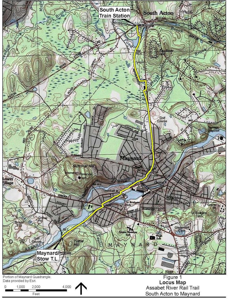
4 ACTON-MAYNARD, MASSACHUSETTS ASSABET RIVER RAIL TRAIL The proposed project displayed for public viewing and comment will be presented in detail to provide the residents of Maynard and Acton a full understanding of the project improvements. Public comments are encouraged and will be recorded and used to assist the Towns and MassDOT during the next and final stage of the rail trail design. Project Description The Massachusetts Department of Transportation Highway Division (MassDOT), in conjunction with the Towns of Maynard and Acton, proposes to construct approximately 3.4 miles of the Assabet River Rail Trail (ARRT) through Maynard and Acton. The ARRT is a proposed multi-use recreational trail and alternative transportation corridor along the B&M Railroad s Marlborough branch line. This project begins at the Stow/Maynard town line at White Pond Road and runs 3.4 miles east and north through Maynard, ultimately ending in South Acton at the South Acton Commuter Rail Station. The project also includes the rehabilitation of the existing railroad trestle over Mill Pond with a prefabricated steel truss bridge, the replacement of the existing pedestrian bridge over the Assabet River in Tobin Park in Maynard with a prefabricated steel truss bridge and a proposed boardwalk over two stormwater basins and a vegetated wetland in Acton. Purpose The municipalities of Maynard, Stow, Hudson, Marlborough, and Acton have been working to develop the Assabet River Rail Trail (ARRT), a mile long rail trail on a former rail line. The ARRT will connect downtowns in Marlborough, Hudson, and Maynard with the South Acton Commuter Rail Station and will connect in-town parks in Marlborough, Hudson, and Maynard with wooded areas, riverfront, and the Assabet River National Wildlife Refuge. The portion of the work in Marlborough and Hudson has been constructed and is being used extensively. The town of Stow is currently working on acquiring the rights to the privately owned land along the proposed trail location. This portion of the ARRT through Acton and Maynard will provide a safer alternative to bicyclists and pedestrians than shared roadway use with motorized vehicles. Existing Conditions The existing location is an former railroad right-of-way that extends from the Stow/Maynard town line, through wooded sections before reaching downtown Maynard, then turning north through mostly wooded sections to the Maynard/Acton town line, then continuing north through Acton until crossing Mill Pond before reaching its terminus at the South Acton MBTA Commuter Rail station. The corridor is lined with thick vegetation and includes significant cut and fill slopes, drainage swales, culverts, wetlands and other obstructions. The Assabet River, Taylor Brook, Pratt Brook, Mill Pond and bordering vegetated wetlands align much of the right-of-way. The segments of right-of-way running parallel to Route 62 and Route 27 are bordered primarily by commercial and residential uses. The remainder of the right-of-way is primarily located adjacent to conservation and wetland areas. Proposed Scope of Work The proposed ARRT section begins at the Stow/Maynard town line at White Pond Road and runs 3.4 miles east and north through Maynard, ultimately ending in South Acton MBTA commuter rail station. Existing conditions of the ARRT vary along the proposed route. The trail begins at White Pond Road/Stow town line and continues easterly along the Marlborough branch railroad right-of-way more or less parallel to the Assabet River, past Ice House Landing and the Maynard DPW garage to Winter Street. The trail in this location follows a gravel road with wooded areas to the right and residential properties to the left. The trail runs along Winter Street for a short distance, crosses Great Road and the mill canal before continuing along the railroad right-of-
 through Maynard and Acton.")
5 way alongside High Street to Sudbury Street. This area is residential and wooded. From there, the trail turns left onto Sudbury Street and then immediately right onto Main Street into the commercial downtown. It runs along the Clock Tower Place parking lot, crosses Main Street to Railroad Street, crosses Florida Road and the Assabet River and travels through the municipal parking lot behind the downtown stores to Summer Street. Once the trail crosses Summer Street, it follows the railroad right-of-way through residential neighborhoods to Haynes Square; crosses Concord Street and continues through some forested areas and open land, crosses Acton Street and continues through some forested land to the Acton Town Line. From the Acton town line, the trail follows the railroad right-of-way, detours around the front of the 20 Main Street facility and reconnects with the former Marlborough branch line to the town-owned farm land south of Maple Street, crosses Maple Street and terminates at the south side of the commuter rail station in South Acton. The majority of the trail in Acton traverses forested land. South of Maple Street the trail passes adjacent to crop land before entering a residential neighborhood. This project will provide important links both locally and regionally. Development of the rail trail will be a strong addition to the communities transportation network and will support future bicycle path connections to adjacent communities. The trail will be used by residents of the communities and visitors of the ARRT and the Assabet River National Wildlife Refuge and provide a vital connection to the MBTA commuter rail station in Acton. Improvement activities will include the following: Paved 8 to 12 foot wide multi-use recreational trail with one or two foot graded shoulders on either side Trail pavement markings and signing Rectangular Rapid Flashing Beacons at trail-roadway crossings Roadway pavement markings and signing at trail crossings Traffic calming features Repair / maintenance of existing culverts Construction of two parking areas/additional spaces at Winter and Florida Streets, Maynard Construction of two parking areas/additional spaces at Sylvia and Maple Streets, Acton Earthwork and landscaping Informational kiosks and trail signage Parking lot and safety lighting Other items incidental to the construction of the trail Replacement of the bridge over the Assabet River in Tobin Park Rehabilitation of the existing railroad trestle over Mill Pond Construction of a boardwalk In addition to the two existing superstructures, there are nine proposed road crossings. The ARRT crosses: Great Road (Route 117) at Mill Street and Winter Street (Maynard), Sudbury Street at Main Street (Route 62) (Maynard), Main Street (Route 62) at Clock Tower Place Driveway (Maynard), Florida Road (Maynard), Summer Street at Maple Street (Maynard), Acton Street (south) at Haynes Street (Route 27) (Maynard), Concord Street at Haynes Street/Brown Street (Route 27) (Maynard), Acton Street (north) at Brown Street (Route 27)/Conant Street (Maynard), Maple Street at Stow Street (Acton). Improvements are proposed at each of the crossings to maintain vehicular capacity while providing a safe and reasonable means of crossing trail users including pavement markings, signing and rectangular rapid flashing beacon installations. Existing drainage patterns are being maintained and runoff from the trail is to be directed to existing or new grass swales. There are several existing cross culverts at various locations along the project which will be cleaned and maintained. Some new cross culverts have been proposed.

6 As part of this project, several areas of project work are expected to impact vegetated wetlands areas in Maynard and Acton. Permanent wetland impacts total 263 square feet. Temporary wetland impacts total 9,502 square feet. Permanent land under water impacts total 6,038 square feet and temporary land under water impacts total 3,344 square feet. The project also proposes impacts to 1,641 linear feet of bank and 1,330 SF of bordering land subject to flooding resulting in 358 CF of impact to floodplain. A Certified Vernal Pool is located in the Assabet River National Wildlife Refuge in Stow, approximately 350 feet southwest of the beginning of the trail in Maynard and is separated from the project limits by the presence of White Pond Road. A potential vernal pool has been mapped in Acton approximately 1,200 feet south of the Mill Pond Bridge, 75 feet west of the trail. Best management practices for erosion and sedimentation control will be adhered to for all phases of construction to minimize impacts to these pools and the adjacent vernal pool habitat. Minimal utility impacts are anticipated as much effort has been undertaken to avoid impacts to utility structures. Two utility poles will require relocations and two fire hydrants will require adjustment in addition to some drainage improvements/modifications. Right-of-Way Impacts Within the project limits, the right-of-way varies between 40 feet and 70 feet which is now owned by the Towns of Acton and Maynard, public right-of-way in the Towns of Acton and Maynard and previously acquired easements. Temporary and permanent easements will be needed from private property owners for work outside these areas. Both Acton and Maynard are currently working with impacted property owners. Project Status / Schedule The Plans on display this evening are 75% complete and currently under review at MassDOT. Comments from the public presentation will be reviewed and addressed in the final design stage. The process will continue to the final Plans, Specifications, and Estimate (PS&E), and the award of construction contract. Construction is anticipated to be complete within two construction seasons (2 years). Currently the project is listed on the 2015 MassDOT Traffic Improvement Program (TIP). With this planned funding being set, construction is anticipated to begin in Project Cost At this time the estimated participating cost of construction is approximately $6.7 million dollars

7 THE COMMONWEALTH OF MASSACHUSETTS MASSACHUSETTS DEPARTMENT OF TRANSPORTATION HIGHWAY DIVISION FEDERAL AID Acton & Maynard, MA Assabet River Rail Trail Project File No This sheet is provided for your comments. Your input is solicited and appreciated. Please return your sheet, with comments, to a staff member at the meeting, or mail to: Patricia A. Leavenworth, P.E., Chief Engineer MassDOT Highway Division 10 Park Plaza, Boston, MA The final date for receipt of written statements and exhibits for inclusion into the official meeting transcript will be ten (10) days after the Informational Meeting. PLEASE TYPE OR PRINT LEGIBLY. Name: Title: Organization: Address:

8 Please Fold and Tape Please Place Appropriate Postage Here Patricia A. Leavenworth, P.E. Chief Engineer MassDOT Highway Division 10 Park Plaza Boston, MA RE: Public Informational Meeting ASSABET RIVER RAIL TRAIL IN THE TOWNS OF ACTON & MAYNARD Project File No Project Management Section

DESIGN PUBLIC HEARING. August 10, 2015 WEST BOYLSTON TOWN HALL, BOARD MEETING ROOM. 140 Worcester Street WEST BOYLSTON, MASSACHUSETTS 6:30 PM
 DESIGN PUBLIC HEARING August 10, 2015 AT WEST BOYLSTON TOWN HALL, BOARD MEETING ROOM 140 Worcester Street WEST BOYLSTON, MASSACHUSETTS 6:30 PM FOR THE PROPOSED Rehabilitation & Stormwater Improvements
Open House Public Meeting for the Thurmond Bridge Rehabilitation Project State Project: State Project S310-25/2-0.10 Federal Project: BR-0252(001)D
D") Open House Public Meeting for the State Project: State Project S310-25/2-0.10 Federal Project: BR-0252(001)D May 7, 2015 Old Glen Jean Bank Glean Jean, WV 4:00-7:00 PM www.transportation.wv.gov PROJECT
Open House Public Meeting for the State Project: State Project S310-25/2-0.10 Federal Project: BR-0252(001)D May 7, 2015 Old Glen Jean Bank Glean Jean, WV 4:00-7:00 PM www.transportation.wv.gov PROJECT
AGENCY COORDINATION AND PUBLIC INVOLVEMENT
 5 AGENCY COORDINATION AND PUBLIC INVOLVEMENT 5.1 AGENCY COORDINATION As part of the planning process for the Oregon Avenue Final EA, DDOT conducted an agency coordination program. This coordination included
3.1 Historical Considerations
 3. Recommended Scope of Bridge improvements 3.1 Historical Considerations In the fall of 2000, an outside consultant, Fraser Design, suggested that the existing 4 th St. Bridge is potentially eligible
 Walkable Communities Florida Department of Transportation State Safety Office Pedestrian and Bicycle Program April 1995 www.dot.state.fl.us/safety Twelve Steps for an Effective Program Page 1 Twelve Steps
March 17, 2015. Dear Mr. Sullins:
 Tony Sullins Endangered Species Chief, Midwest Regional Office Public Comment Process Attn: FWS-R5-ES-2011-0024 Division of Policy and Directives Management U.S. Fish and Wildlife Service 4401 N. Fairfax
3 Tappan Zee Bridge Rehabilitation Options
 3 Tappan Zee Bridge Rehabilitation Options 3.1 Introduction This chapter describes possible options that rehabilitate and enhance the existing Tappan Zee Bridge. Four Rehabilitation Options have been developed:
Informational Workshop Public Meeting Kanawha Falls Bridge Project
 Informational Workshop Public Meeting Kanawha Falls Project WV Department of Transportation Division of Highways in Cooperation with the Federal Highway Administration State Project S310-13-0.02 00 Federal
Narrative Response/Attachment 1 (WisDOT 2014-2018 TAP- Second Round Application ID-SWBP22)
") Narrative Response/Attachment 1 (WisDOT 2014-2018 TAP- Second Round Application ID-SWBP22) 2. For Bicycle and Pedestrian Projects: Clearly indicate the location, length, width, surface materials, and any
Narrative Response/Attachment 1 (WisDOT 2014-2018 TAP- Second Round Application ID-SWBP22) 2. For Bicycle and Pedestrian Projects: Clearly indicate the location, length, width, surface materials, and any
2010 Salida Community Priorities Survey Summary Results
 SURVEY BACKGROUND The 2010 Salida Community Priorities Survey was distributed in September in an effort to obtain feedback about the level of support for various priorities identified in the draft Comprehensive
Muddy River Restoration Project Project Description
 Muddy River Restoration Project Project Description Since the fall of 1996, the Muddy River has flooded three times, causing damage to residents, businesses institutions and the public transit system in
Red Wing Bridge Project. PAC #5/TAC #8 Meeting July 18, 2013
 Red Wing Bridge Project PAC #5/TAC #8 Meeting July 18, 2013 Alternatives Analysis Agenda Overview of Past Progress Progress Since April PAC Bridge 9103 Rehabilitation Study Bridge 9040 Rehab vs. Replacement
CLACKAMAS COUNTY ZONING AND DEVELOPMENT ORDINANCE
 1008 STORM DRAINAGE (3/24/05) 1008.01 PURPOSE To minimize the amount of stormwater runoff resulting from development utilizing nonstructural controls where possible, maintain and improve water quality,
Alternatives to the Circ Project Prioritization Methodology Prepared for Circ Task Force July 28, 2011
 Alternatives to the Circ Project Prioritization Methodology Prepared for Circ Task Force July 28, 2011 CCRPC staff has developed a draft methodology described below and detailed in the attached pages for
APPENDIX F RIGHTS-OF-WAY PRESERVATION GUIDELINES
 Los Angeles County Metropolitan Transportation Authority (Metro) 2009 Transportation Improvement Program Call for Projects APPENDIX F RIGHTS-OF-WAY PRESERVATION GUIDELINES Los Angeles County Metropolitan
PLANNED UNIT DEVELOPMENT & SIDEWALK WAIVER REQUEST STAFF REPORT Date: November 7, 2013
 PLANNED UNIT DEVELOPMENT & SIDEWALK WAIVER REQUEST STAFF REPORT Date: November 7, 2013 NAME LOCATION Audubon Properties, LLC. 4700 & 4960 Dauphin Island Parkway West side of Dauphin Island Parkway, 580
SR-18 Corridor Improvements in Wood County
 Public Meeting Information Package SR- Corridor Improvements in Wood County Thursday, May 19, 2011 10:00 a.m. to 1:00 p.m. Meeting Location: Hancock-Wood Electric Cooperative Building 1399 Business Park
A. Describe the existing drainage patterns on-site as shown on Map I, including any potential flooding and erosion problems.
 19. STORMWATER MANAGEMENT A. Describe the existing drainage patterns on-site as shown on Map I, including any potential flooding and erosion problems. The majority of the approximately ±500 acre Property
KENTUCKY TRANSPORTATION CABINET. Department of Rural and Municipal Aid. Office of Local Programs
 KENTUCKY TRANSPORTATION CABINET Department of Rural and Municipal Aid Office of Local Programs Office of Local Programs Transportation Enhancements Safe Routes to School Congestion Mitigation and Air Quality
The Basics of Chapter 105 Waterways and Wetlands Permitting in PA
 The Basics of Chapter 105 Waterways and Wetlands Permitting in PA April 17, 2013 Goal To develop a basic understanding of PA Department of Environmental Protection (DEP) and US Army Corps of Engineers
Mission Creek Flood Control & Restoration Project. City of Fremont, Alameda County
 Mission Creek Flood Control & Restoration Project City of Fremont, Alameda County Agenda Background Why are proposed improvements necessary? Proposed project components Challenges Construction schedule/phasing
Belmont Street Bridge Rehabilitation Project
 Belmont Street Bridge Rehabilitation Project Christian Gospel Church Worcester 43 Belmont Street Worcester MA February 20, 2015 7:00PM Agenda Introductions Project site and overview Project history Construction
DESCRIPTION OF WORK:
 DEPARTMENT OF PUBLIC WORKS COUNTY OF HENRICO P.O. BOX 27032 RICHMOND, VIRGINIA 23273 PERMIT NO. One (1) copy of application and four (4) copies of plans are hereby made to the Director of Public Works
Alternatives Presentation Meeting Middlebury WCRS(23)
") Alternatives Presentation Meeting Middlebury WCRS(23) Main Street (VT 30/TH 2 Bridge 102) and Merchants Row (TH 8 Bridge 2) over Vermont Railway June 4, 2013 Twilight Hall Auditorium, Middlebury College
Alternatives Presentation Meeting Middlebury WCRS(23) Main Street (VT 30/TH 2 Bridge 102) and Merchants Row (TH 8 Bridge 2) over Vermont Railway June 4, 2013 Twilight Hall Auditorium, Middlebury College
Goals & Objectives. Chapter 9. Transportation
 Goals & Objectives Chapter 9 Transportation Transportation MISSION STATEMENT: TO PROVIDE A TRANSPORTATION NETWORK CAPABLE OF MOVING PEOPLE AND GOODS EFFICIENTLY AND SAFELY. T he transportation system
DESIGN ASSISTANCE APPLICATION
 DESIGN ASSISTANCE APPLICATION for FY 2016 NEW RIVER MULTI USE PATH: PINNACLE PEAK ROAD TO HAPPY VALLEY ROAD CITY OF PEORIA APPLICATIONS ARE DUE VIA ONLINE SUBMITTAL BY 10:00 AM ON MONDAY, JUNE 29, 2015
Floodplain Development Land Use Review
 COMMUNITY DEVELOPMENT DEPARTMENT Planning Division P.O. Box 490 333 Broadalbin Street SW Albany, OR 97321 Phone 541-917-7550 Fax 541-791-0150 www.cityofalbany.net Floodplain Development Land Use Review
BEST PRACTICES. Smart Transportation is a key concept for the Paoli Roadway Improvement Project.
 Smart Transportation Smart Transportation is a key concept for the Paoli Roadway Improvement Project. PennDOT s Smart Transportation Guidebook (2008) outlines a comprehensive approach to transportation
Lincoln Downtown Master Plan Update
 Lincoln Downtown Master Plan Update Table of Contents Executive Summary........................................... 1 Complete Streets Framework.................................... 3 Promenade Creating
Background and Goals for the Project
 City of Asheville, NC REQUEST FOR PROPOSALS Wilma Dykeman Riverway Environmental Analysis, Project Development, and Preliminary Design Submittal Address: Dan Baechtold, AICP City of Asheville Engineering
FINDING OF NO SIGNIFICANT IMPACT FOR ROCK CREEK PARK MULTI-USE TRAIL REHABILITATION WASHINGTON, DC
 FOR ROCK CREEK PARK MULTI-USE TRAIL REHABILITATION WASHINGTON, DC The District Department of Transportation (DDOT), in conjunction with the Federal Highway Administration (FHWA), the National Park Service
Stormwater Wetland Design and Construction Mitigation Duke Bitsko. Construction Activities, Schedule and Sequence Tom Ritchie
 September 7, 2011 Welcome Catherine Daly Woodbury DCR Coordination Dan Driscoll Project Background Catherine Daly Woodbury Stormwater Wetland Design and Construction Mitigation Duke Bitsko Construction
MOBILE HOME LAW. Revised November 2001
 MOBILE HOME LAW Revised November 2001 TABLE OF CONTENTS: SECTION 1: SECTION 2: SECTION 3: SECTION 4: SECTION 5: SECTION 6: SECTION 7: SECTION 8: SECTION 9: SECTION 10: SECTION 11: SECTION 12: INTENT DEFINITIONS
City of Douglas Commercial Building Permit Site Application
 City of Douglas Commercial Building Permit Site Application *Complete the following information including a complete site plan and floor plan. *Incomplete information may result in delay and/or rejection
Infrastructure assets are distinguished from other capital assets because they normally:
 4. REPORTING 4.2 Government-Wide Financial Statements 4.2.6 Infrastructure Reporting 4.2.6.10 Governments are required to report all of their capital assets in the statement of net position. Infrastructure
The Bond Release Process for New Subdivision Developments: An Overview for Homeowners Associations DRAFT 6-4-08. Revised 9-25-08
 The Bond Release Process for New Subdivision Developments: An Overview for Homeowners Associations DRAFT 6-4-08. Revised 9-25-08 Fairfax County requires developers to post a performance bond if they are
TOWN OF NEW HAVEN ROAD PLAN
 1 TOWN OF NEW HAVEN ROAD PLAN BACKGROUND The Town of New Haven, Vermont consists of 42 square miles of land and a population of approximately 1400 people. At the start of the 21 st century, it is served
Homeowner s Guide to Drainage
 Homeowner s Guide to Drainage a scottsdale homeowner s guide to drainage produced by the city of scottsdale s stormwater management division Transportation Department TABLE OF CONTENTS Introduction 2 Drainage
PLANNING DIVISION STAFF REPORT February 23, 2015. Summary. Background Information PREPARED FOR THE PLAN COMMISSION. Legistar File ID # 36810
 PLANNING DIVISION STAFF REPORT PREPARED FOR THE PLAN COMMISSION Project Address: Application Type: Legistar File ID # 36810 Prepared By: Summary Conditional Use Timothy M. Parks, Planning Division Report
1800 Washington Boulevard, Baltimore, MD 21230-1718 www.mde.maryland.gov 410-537-3000 800-633-6101 TTY Users 800-735-2258 Larry Hogan, Governor Boyd
 ENVIRONMENTAL SITE DESIGN (ESD) REDEVELOPMENT EXAMPLES OCTOBER 2010 1800 Washington Boulevard, Baltimore, MD 21230-1718 www.mde.maryland.gov 410-537-3000 800-633-6101 TTY Users 800-735-2258 Larry Hogan,
Project R-4467 PROJECT DESCRIPTION PROJECT SCHEDULE PURPOSE OF THIS MEETING WHAT WILL BE DONE WITH THE COMMENTS? FOR MORE INFORMATION:
 Workshop #3 Aug ust 2012 PROJECT DESCRIPTION The North Carolina Department of Transportation (NCDOT) proposes to maintain a direct highway connection between Hertford and Winfall along or close to US 17
Chehalis River Basin Flood Damage Reduction 2013-2015 Capital Budget Approved by Legislature in June 2013
 Chehalis River Basin Flood Damage Reduction 2013-2015 Capital Budget Approved by Legislature in June 2013 1. Design alternatives for large capital flood projects (basinlevel water retention and Interstate
SECTION 08000 STORM DRAINAGE TABLE OF CONTENTS
 SECTION 08000 STORM DRAINAGE 08010 DESIGN A. Location B. Sizing TABLE OF CONTENTS 08020 MATERIALS A. Pipe Materials B. Structure Materials C. Installation D. Inlets and Outlets 08030 INSPECTIONS AND TESTING
Assessing Paved Trails for Compliance with Standards and Best Practices
 Assessing Paved Trails for Compliance with Standards and Best Practices Session Presenters: Kristin Maravilla, Planner/Designer Masters in Landscape Architecture (UC Berkeley) Masters in City and Regional
CITY OF ROANOKE AND TOWN OF VINTON, VIRGINIA. RSTP Funds Joint Application FOR
 CITY OF ROANOKE AND TOWN OF VINTON, VIRGINIA RSTP Funds Joint Application FOR Tinker Creek Pedestrian Bridge: Tinker Creek and Glade Creek Greenways Connection Date: September 15, 2014 RSTP Project Profile
Guidelines for. Permeable Pavement
 What is permeable pavement? Guidelines for Permeable Pavement When rainwater falls on conventional pavement, such as concrete, it accumulates and then flows across and off of this impervious surface as
THE COMMONWEALTH OF MASSACHUSETTS MASSACHUSETTS HIGHWAY DEPARTMENT PROJECT INITIATION FORM (PIF)
") THE COMMONWEALTH OF MASSACHUSETTS MASSACHUSETTS HIGHWAY DEPARTMENT PROJECT INITIATION FORM (PIF) To: From: Contact Information: Roland Bartl, Planning, Town of Acton, 472 Main St. Acton MA 01440; 978-264-9639;
THE COMMONWEALTH OF MASSACHUSETTS MASSACHUSETTS HIGHWAY DEPARTMENT PROJECT INITIATION FORM (PIF) To: From: Contact Information: Roland Bartl, Planning, Town of Acton, 472 Main St. Acton MA 01440; 978-264-9639;
Whitby. Key Requirements. Primary Municipal Contact. Documentation
 Key Requirements Application should be submitted 10 business days in advance Location fee Required for filming on streets and property, including parks and facilities, under the jurisdiction of the Corporation
MICHIGAN S LANDSCAPE ARCHITECTS
 MICHIGAN S LANDSCAPE ARCHITECTS protecting the health, safety, and welfare of our citizens site design land use planning master planning streetscape design brownfield redevelopment guidelines and regulations
BASSETT CREEK VALLEY MASTER PLAN OPEN HOUSE
 BASSETT CREEK VALLEY MASTER PLAN OPEN HOUSE February 23, 2006 PROJECT INTRODUCTION Project Area 230 acres $50 million estimated market value (approximately) 50 acres parkland 100 residences (estimated)
REGIONAL NON-MOTORIZED TRANSPORTATION NETWORK
 Chapter 10 Bicycle and Pedestrian SAFETEA-LU legislation requires that non-motorized users be considered in the LRTP. The legislation allows for bicycle and pedestrian safety to be incorporated into the
Exhibit A Scope of Work
 Exhibit A Scope of Work The agreement for S.P. 3116-142 (T.H. 169-Cross Range Expressway) includes final design plans for a 1.55 mile length of a 2 lane to 4 lane expansion project located 0.66 miles SW
Chapter 2 PLAN AND PLAT REVIEW PROCESS
 www.cityofknoxville.org/engineering/ Chapter 2 PLAN AND PLAT REVIEW PROCESS 2.1 Overall Sequence for Large Projects The overall sequence of major development and redevelopment projects will generally follow
Land Disturbance, Erosion Control and Stormwater Management Checklist. Walworth County Land Conservation Department
 Land Disturbance, Erosion Control and Stormwater Management Checklist Walworth County Land Conservation Department The following checklist is designed to assist the applicant in complying with the Walworth
LIMITED SCOPE CONCEPT DEVELOPMENT REPORT
 LIMITED SCOPE CONCEPT DEVELOPMENT REPORT Route 33 Resurfacing Project Eastbound: Milepost 24.2 to Milepost 28.9 Westbound: Milepost 24.3 to Milepost 28.9 Manalapan & Freehold Townships, Monmouth County
INSTITUTIONAL MASTER PLAN NOTIFICATION FORM / PROJECT NOTIFICATION FORM BOSTON UNIVERSITY MEDICAL CENTER
 INSTITUTIONAL MASTER PLAN NOTIFICATION FORM / PROJECT NOTIFICATION FORM BOSTON UNIVERSITY MEDICAL CENTER JUNE 7, 2013 SUBMITTED TO: BOSTON REDEVELOPMENT AUTHORITY ONE CITY HALL SQUARE BOSTON, MA 02201
1. It would create hazardous effects of storm water run-off. 3. It would increase hazardous driving conditions on the public road.
 SECTION 6: REQUIREMENTS FOR A DRIVEWAY CONNECTION A. Required information. The application shall be accompanied by a sketch of the proposed driveway which at a minimum shall indicate: 1. Geometric information
Alewife Working Group June 14, 2016
 Alewife Working Group June 14, 2016 cambridgema.gov/citywideplan 1 Agenda What we ve heard Past plans and studies for Alewife Alewife Revitalization Plan (1979) Citywide Plan (1997-2000) Concord-Alewife
APPENDIX B: TRAIL DEVELOPMENT AND MANAGEMENT STANDARDS
 APPENDIX B: TRAIL DEVELOPMENT AND MANAGEMENT STANDARDS This section provides guidance on a variety of trail issues for planners and developers of the Ice Age NST across the state. It also provides introductory
SEMINOLE PRATT WHITNEY ROAD & NORTHLAKE BLVD. FREQUENTLY ASKED QUESTIONS
 UPDATED: 01/31/14 SEMINOLE PRATT WHITNEY ROAD & NORTHLAKE BLVD. FREQUENTLY ASKED QUESTIONS Q. 1. What are the County s plans for Seminole Pratt Whitney Road between SR 80 (Southern Blvd) and the Bee Line
Interlocking Concrete Pavement Institute (ICPI) Model Stormwater Ordinance for Permeable Interlocking Concrete Pavements August 2010
 Model Stormwater Ordinance for Permeable Interlocking Concrete Pavements August 2010") Interlocking Concrete Pavement Institute (ICPI) Model Stormwater Ordinance for Permeable Interlocking Concrete Pavements August 2010 Background What are permeable interlocking concrete pavements (PICP)?
Interlocking Concrete Pavement Institute (ICPI) Model Stormwater Ordinance for Permeable Interlocking Concrete Pavements August 2010 Background What are permeable interlocking concrete pavements (PICP)?
Chapter 5. Transportation. Decatur County Comprehensive Plan. Introduction. Goals and Objectives. Goal. Objectives. Goal.
 Chapter 5 Transportation Chapter 5: Transportation Introduction The transportation system forms the backbone of a community. I-74 connects Decatur County with the large metropolitan areas of Cincinnati
AREA: 0.16 acres NUMBER OF LOTS: 1 FT. NEW STREET: 0 LF
 FILE NO.: Z-9020 NAME: Hometown Tax Service Short-form PD-O LOCATION: Located at 3008 West 12 th Street DEVELOPER: Mark Green 65 Westfield Loop Little Rock, AR 72210 SURVEYOR: Kittler-Roberts Group, LLP
Alternatives Evaluation Overview
 Alternatives Evaluation Overview 124 Alternatives were analyzed against the evaluation criteria Criteria and criteria weighting were set by the Community Task Force Ratings were quantitative and qualitative
ORDINANCE CODES FOR PARKING TICKETS
 ORDINANCE CODES FOR PARKING TICKETS Ordinance Ordinance Fine Fine if towed Code 001 Expired Meter (Municipal Lot) - Did park a motor vehicle in a municipal lot without paying or depositing in the meter,
September 2005. Sponsored by: John H. Chafee Blackstone River Valley National Heritage Corridor Commission Woonsocket, RI
 Sponsored by: John H. Chafee Blackstone River Valley National Heritage Corridor Commission Woonsocket, RI Worcester Historical Museum Worcester, MA September 2005 mawald/ld/0909700/graphics/covers/september05cover
Bond Release Process for New Subdivision Developments in Fairfax County
 Bond Release Process for New Subdivision Developments in Fairfax County An Overview for Homeowners Associations A Fairfax County, Va., publication April 2009 For more information or to request this document
Motorcycle & Pedestrian Master Plans in Indianapolis, Indiana
 PROJECT PURPOSE The Warsaw + Winona Lake Bicycle and Pedestrian Master Plan establishes a comprehensive framework for a connected bicycle and pedestrian system that will be used for both recreation and
Clean, Green, Fun! Cady Way. Trail
 Clean, Green, Fun! Cady Way Trail Seminole County Burkett Osceola 426 Mizell Sylvan 426 Ward Memorial Cady Way 436 426 551 Nan Waunatta Martha Mira Pearl George Virginia Berry Irma Winter Pines Golf Course
US 281 AT PREMONT PUBLIC HEARING. US 281 at Premont Public Hearing
 US 281 AT PREMONT PUBLIC HEARING Hearing Purpose The purpose of tonight s Public Hearing is for the public to: Learn about the status of the proposed project Review the purpose and need for the project
AN INITIATIVE TO IMPROVE
 L OW E R C A R M E L R I V E R A N D L AG O O N F L O O D P L A I N R E S TO R AT I O N A N D E N H A N C E M E N T P R O J E C T AN INITIATIVE TO IMPROVE FLOOD PROTECTION RESTORE AND PROTECT RIPARIAN
Engineering. 2006 2007 2007 2008 2008 2008 Major Service Actual Budget Projected Request Executive Adopted
 Engineering Agency Number: 53 Budget Function: Public Works and Transportation The Engineering Division is responsible for the design, supervision and inspection of all street, highway, sidewalk and bike
Update on Previous Related Transportation Enhancement Grants
 ROUND 16 ROUND 16 Update on Previous Related Transportation Enhancement Grants Pima County and City of Tucson staff are implementing the Pima County-Tucson Safe Routes to Schools Pilot Program. This program
How To Amend A Stormwater Ordinance
 Regulatory Alternatives to Address Stormwater Management and Flooding in the Marlboro Street Study Area Alternative 1: Amend Existing Local Regulations This proposed alternative provides an incremental
Revere Beach Transit-Oriented Development Parcels Revere, Massachusetts. Design and Development Guidelines. Part Two.
 Revere Beach Transit-Oriented Development Parcels Revere, Massachusetts Design and Development Guidelines Request for Qualifications and Expressions of Interest with Preliminary Development Plans Part
Public Information & Public Scoping Meeting
 Public Information & Public Scoping Meeting William F. Cribari Memorial Bridge Route 136 over the Saugatuck River Review of Rehabilitation Study Report Public Scoping for the gathering and analysis of
DRAFT. Light Rail Corridor Shared-Use Path Study. September 2014. Prepared for: Prepared by:
 Light Rail Corridor Shared-Use Path Study Prepared for: Prepared by: Introduction With the plans to extend transit from ewtown Road to the oceanfront in the City of Virginia Beach progressing, there is
TRAFFIC MANAGEMENT PLAN
 TRAFFIC MANAGEMENT PLAN For: The construction and operation of a Photovoltaic (PV) Facility in Dabenoris, South Africa Prepared for: Alternative Energy Solutions (Pty) Ltd PO Box 4939 Tygervalley, South
Welcome Welcome to the public exhibition for development at Bowman Field. This exhibition provides an overview of the proposals for the site.
 Welcome Welcome to the public exhibition for development at Bowman Field. This exhibition provides an overview of the proposals for the site. Background & Planning Context The Site The site is an area
(As amended by By-law 68-2014) By-law 78-91 of The Corporation of the City of Oshawa
 By-law 78-91 of The Corporation of the City of Oshawa") (As amended by By-law 68-2014) By-law 78-91 of The Corporation of the City of Oshawa being a by-law to regulate and control the use of skateboards, bicycles and similar devices within the City of Oshawa.
(As amended by By-law 68-2014) By-law 78-91 of The Corporation of the City of Oshawa being a by-law to regulate and control the use of skateboards, bicycles and similar devices within the City of Oshawa.
Walking Route the assigned or authorized route a pupil walks to arrive at school or at the designated bus stop.
 BUSINESS NON-INSTRUCTION OPERATION 3541 TRANSPORTATION I. GENERAL It is the goal of the Board of Education to establish for the public schools an appropriate transportation system one which will enable
Township of Enniskillen. Asset Management Plan
 Township of Enniskillen Asset Management Plan 2014 1 TABLE OF CONTENTS Page A. Introduction 3 B. State of Local Infrastructure 4 C. Desired Levels of Service 7 D. Asset Management Strategy 8 E. Financing
March 2008. Prepared by: Irvine Ranch Water District. 15600 Sand Canyon Avenue. Irvine, CA 92618. Contact: Natalie Likens (949) 453-5633
 453-5633") ADDENDUM TO THE MICHELSON WATER RECLAMATION PLANT PHASE 2 & 3 CAPACITY EXPANSION PROJECT FEBRUARY 2006 FINAL ENVIRONMENTAL IMPACT REPORT AND THE SAN JOAQUIN FRESHWATER MARSH ENHANCEMENT PLAN REVISED SEPTEMBER
ADDENDUM TO THE MICHELSON WATER RECLAMATION PLANT PHASE 2 & 3 CAPACITY EXPANSION PROJECT FEBRUARY 2006 FINAL ENVIRONMENTAL IMPACT REPORT AND THE SAN JOAQUIN FRESHWATER MARSH ENHANCEMENT PLAN REVISED SEPTEMBER
Harris County Flood Control District. Policy, Criteria, and Procedure Manual
 Harris County Flood Control District Policy, Criteria, and Procedure Manual For Approval and Acceptance of Infrastructure General Review October 10, 2003 Draft Please Provide Written Comments to the HCFCD
Public Involvement Meeting Handout
 Public Involvement Meeting Handout WIS 93 Detloff Drive to WIS 95 Trempealeau County Project ID 7130-01-72 June 18, 2014 5:00 P.M. 401 W. Main Street Arcadia WI Purpose of the meeting The Wisconsin Department
FILE NO.: Z-6915-C. Gamble Road Short-form PCD and Land Alteration Variance Request
 FILE NO.: Z-6915-C NAME: Gamble Road Short-form PCD and Land Alteration Variance Request LOCATION: Located on the Northwest corner of Chenal Parkway and Gamble Road DEVELOPER: Davis Properties P.O. Box
Prattsville Berm Removal Project. 1.0 Project Location
 Prattsville Berm Removal Project 1.0 Project Location The project site is located between the New York State Route 23 Bridge over the Schoharie Creek and the Schoharie Reservoir. The restoration plan encompassed