BASSETT CREEK VALLEY MASTER PLAN OPEN HOUSE
|
|
|
- Whitney Reed
- 8 years ago
- Views:
Transcription
1 BASSETT CREEK VALLEY MASTER PLAN OPEN HOUSE February 23, 2006

2 PROJECT INTRODUCTION Project Area 230 acres $50 million estimated market value (approximately) 50 acres parkland 100 residences (estimated) 175 acres commercial / industrial land
 175 acres commercial")
3 Guiding Principles Bassett Creek Valley Redevelopment Plan 1. Enhance the Valley s natural features: Restore natural features, preserve views, expand open space, and clean up pollution. Increase the ability for natural features to impact the Valley s quality of life by sensitively designing them for the enjoyment of people. 2. Create a park-like setting in developed areas: Use landscape techniques to create a park-like character in developed areas and to diffuse the distinction between uses. 3. Use Van White Memorial Boulevard and the Bassett Creek open space corridor to shape land development patterns: These two powerful elements should act as a celebrated framework within which development occurs. 4. Preserve current and create new views and sight lines: Development patterns and design guidelines should be sensitive to the preservation of skyline views, views of landmarks and views of open space. 5. Redevelop the Valley with human scale, safety, sustainability and environmental respect in mind: Redevelopment should support a unique community character centered on comfort and security for residents and visitors. 6. Establish creative and innovative urban design guidelines that guide redevelopment and rehabilitation: Innovative urban design and architecture will reinforce the area s appeal as an attractive and vibrant neighborhood for residents and visitors. 7. Create attractive and vibrant districts where people live, work, do business and gather: Mixed-use districts will offer the Valley neighborhood variety and energy as well as vital commercial services, housing choices and jobs. 8. Explore proven and innovate planning concepts for best utilization of land: Explore land use scenarios that consider economic viability, environmental clean-up needs and recreational demands. 9. Accommodate multiple modes of transportation: The Valley should contain overlapping networks of transportation systems including streets, sidewalks, trails and transit. 10. Accommodate affordable housing, living-wage jobs and job training: Bassett Creek Valley has a rich history of population and economic diversity that should be respected in the redevelopment process through provisions for affordable housing and living-wage jobs.

4 Community Issues Change in the Valley is critical: There is widespread recognition that significant change in Bassett Creek Valley and a strategy to foster appropriate change are needed. New open space is needed: With the proposed addition of several thousand new housing units, additional open space and neighborhood park facilities will be essential. This open space should build from the opportunity to restore Bassett Creek. Changes to Bryn Mawr Meadows Park need to be planned with the neighborhood: Plans to modify the program for Bryn Mawr Meadows Park is a sensitive topic and needs to be conducted in the context of meaningful neighborhood participation. Affordable housing is essential: Creation of affordable housing is a primary community goal for Bassett Creek Valley. Financial modeling and the land use plan created with this master plan incorporate consideration for affordable housing. Living wage jobs and job training should be inherent to redevelopment: The diverse population surrounding Bassett Creek Valley wants opportunities to work close to where they live. Redevelopment of office, retail and industrial uses offer an opportunity to build an objective approach to job training and provisions for living-wage jobs. Good design matters: The community is very aware of good and poor design examples in redevelopment projects. They want to do what is possible to ensure a high standard of design in Bassett Creek Valley for both private and public space.

5 Site Photos Residential street Rail corridor PROJECT BACKGROUND View down Glenwood International Market Square Industrial buildings Bryn Mawr neighborhood Storage uses Bryn Mawr Meadows Cedar Lake Trail Impound lot and City views

6 Existing Land Use Data Source: Metropolitan Council Generalized Land Use Year 2000

7 Strengths Site Analysis Parkland Regional trail links Proximity to Downtown Skyline views Future Van White Memorial Blvd. International Market Square Future freeway access

8 EXPLORING ALTERNATIVES Community Workshops 4 Open houses 450 participants (and counting) Conducted in 5 languages Meaningful community participation and consensus building

9 Public Infrastructure streets & utilities THE PLAN Land Use Plan More than 3,000 housing units 2.5 million square feet of commercial space 45 acres of new open space 1 billion dollars in reinvestment Future real estate value of over a billion dollars Acreage Lower Density Residential - 14 ac. Medium Density Residential - 26 ac. Mixed Use: Office/Retail/Housing - 30 ac. Mixed Use: Office/Housing - 15 ac. Office - 5 ac. Office/Light Industrial - 20 ac. Civic - 4 ac. Park and Open Space - 96 ac.

10 View Analysis From Bryn Mawr Meadows From I-394 Strategic placement of taller buildings Protect and frame skyline views From Cedar Lake Trail From Bryn Mawr Meadows

11 View Analysis - Relationship to Downtown

12 Land Use Typology Lower D ensity Residential units per acre 2-3 Story buildings Garage parking Housing types: Single family detached, single family attached, mansion homes, townhomes, rowhuses, carriage house units. Medium Density Residential units per acre 2-8 story buildings Surface and underground parking Housing Types: townhome, stacked townhome, apartments Mixed Use: Housing /O ffice /Retail units per acre 26,000 SF of retail/office 85 jobs per acre (estimated) 3-7 story buildings with 1-2 floors of office or retail with housing above Structured and underground parking
 3-7 story buildings with")
13 Mixed Use: Housing /O ffice units per acre 25,000-75,000 SF of office 255 jobs per acre (estimated) 6-25 story buildings Structured parking O ffice 60,000-90,000 sf per acre of office 300 jobs per acre (estimated) 6-25 story buildings Structured parking Office /Light Industrial 15,000 sf per acre of development 50 jobs per acre (estimated) 1-2 story buildings Surface parking Civic Transit station and/or school 25,000 SF/acre Park and O pen Space Encompasses active and passive park areas

14 IMPLEMENTATION Phasing Creek - 25 Acres
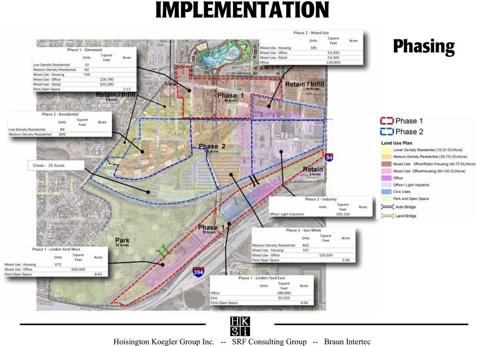
15 Financial Analysis Divide Valley into sub-districts and phases Quantify the redevelopment plan Type and amount of development Activities needed to facilitate development Revenues available to support these costs Do revenues exceed expenses? Broad assessment of financial feasibility Not a specific plan of finance Cannot accurately predict every variable Describe public actions and investments Frame elements of successful redevelopment

16 Financial Analysis

17 Van White Memorial Boulevard Bassett Creek Valley Redevelopment Plan Implementing the Plan May 2006 Approve Approve Master Master Plan Plan Initiate Initiate Phase Phase 1 1 Redevelopment Redevelopment Make Make Key Key Policy Policy Decisions Decisions Make Make Other Other Plan Plan Designations Designations Establish Establish Land Land Use Use Controls Controls Glenwood Avenue Commercial Node Bassett Creek Restoration Linden Yard East Linden Yard West Relocation of Impound Lot Opportunities for Affordable Housing Funding Plan for Infrastructure Funding Plan for Park and Open Space Establishment of TIF District(s) Designate BCV as Growth Center and Redevelopment Project Amend Comprehensive Plan Designate Glenwood as Commercial Corridor Modify Zoning Regulations Designate Glenwood-Van White as Commercial Node Add Design Guidelines
 Designate BCV as Growth Center and Redevelopment Project Amend Comprehensive Plan Designate Glenwood as Commercial")
18 DESIGN GUIDELINES Communicate design vision and desired character Define the relationship and transition between public and private spaces Define both design and environmental performance Build upon zoning requirements Could be used as a basis for development and rehabilitation proposal review Could be one of the determining factors in public financial participation Hoisington Koegler Group Inc. -- SRF Consulting Group -- Braun Intertec

19 Design Guidelines - Examples
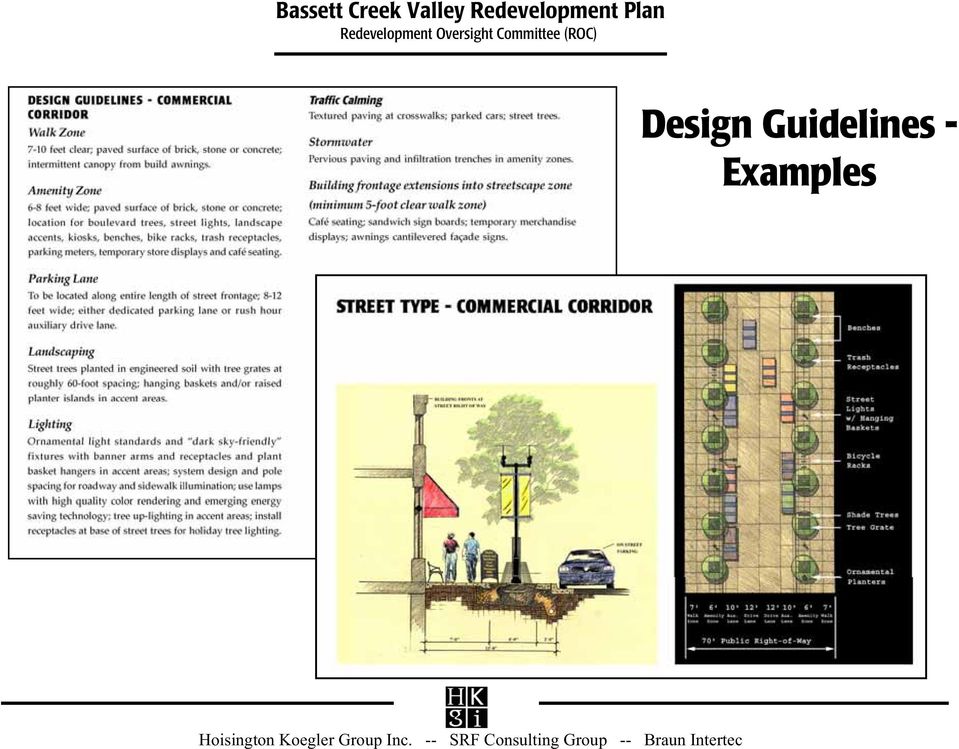
20 Design Guidelines Bassett Creek Valley Redevelopment Plan Street Type Diagram Design Guideline Matrix Design guidelines address both the public realm (streets and public spaces) and the private realm (yards and buildings). Each street type allows for certain frontages based on land use Street Type - Residential Frontage Types Common yard (top), front yard (bottom right), door yard (bottom left) For example, a residential street will have frontage types of door yard, front yard or common yard
, door yard (bottom left) For example, a residential street will have frontage types of door yard,")
21 Stormwater Treatment Bassett Creek Valley Redevelopment Plan Strategies for stormwater treatment: Minimize impervious surfaces Green Roofs Pervious/permeable/porous pavement Bioretention Basins (rain gardens, bioswales, and filter strips) Alternative Storage Devices (for example, cisterns to store water for landscape irrigation) NURP ponds (traditional wet detention ponds) Rainwater Gardens (above) capture runoff from small storms, promote infiltration and are an attractive amenity in the landscape Pervious pavement (above) Filter Strips and trenches are devices that reduce runoff (above and right)
22 Jobs & Housing Summary Bassett Creek Valley Redevelopment Plan 8,000-10,000 jobs (4,000+ in Phase 1) Total new homes: 3,000 to 5,000 1,200+ in Phase 1 Homes at affordable levels: 600+ Neighborhood organizations committed to affordable housing City Policy requires 20% affordable units for public financial assistance of redevelopment Redevelopment Oversight Committee advocating more affordable housing than City policy
23 Immediate Next Steps Presentation to Bryn Mawr Neighborhood Board on March 8 Presentation to Harrison Neighborhood Board on March 13 City of Minneapolis review currently Minneapolis Planning Commission review April / May City Council Approval May / June
24 Key Questions: How is housing affordability ensured? City has 20% affordable housing requirement when public funds are used in redevelopment ROC is committed as longterm advocate of affordable housing and will have oversight of redevelopment Affordable housing contribution factored into master plan financial model
25 Key Questions: How does the project provide living-wage jobs? Redevelopment will create over 8,000 jobs at all levels New jobs are within walking distance ROC is committed to working with developers to create living-wage jobs & job training
26 Key Questions: Why is the scope of the project so large (230 acres)? Project boundary touches adjacent forces of influence on all sides Smaller area risks missing opportunities or avoiding constraints Implementation is a series of actions spanning 2+ decades Master plan answers question of what is planned next door to my property
27 Key Questions: Why so much intensity in Linden Yard? Direct freeway access No negative impact to neighborhood views from north or south of I-394 Land is 3-4 stories below freeway Because of taller buildings, open space can be preserved Intensity is essential as financial seed in other parts of Valley
28 Key Questions: What happens to impound lot & public works? Acquisition and relocation contribution factored into financial model City already plans to relocate public works in Linden Yard Future project can blend impound operations with private redevelopment Redevelopment of Linden Yard should be tied to impound lot solution
29 Key Questions: Why is Bassett Creek Commons proposed as habitat restoration, trails & playground instead of ball fields? Restoring Bassett Creek and surrounding habitat is the right thing to do Diverse residents demand diverse open space and recreational experiences With Bryn Mawr Meadows next door, it provides a good mix of active play areas and passive open space
30 Key Questions: Are bridges across the railroad needed? Success of future housing & office in Linden Yard depends on strong neighborhood ties that bridges create West bridge offers shared parking with Bryn Mawr Meadows (helps solve current neighborhood parking conflict) East bridge needed for traffic circulation flexibility Bridges will enhance neighborhood access to Cedar Lake Trail
Urban Houston Framework SAC Web Meeting March 27th Houston, Texas
 petersgroup consulting Agenda Introduction Overall process (schedule, scope) Review of Vision Workshop Pilot Projects Discussion Westchase Montrose-Westheimer OST/Griggs Moving Towards Conclusions Process
Scenario Planning Report. Austin South Shore Central
 View of Downtown Austin from South Shore s Statesman site. Introduction Austin s South Shore Central Sub-District South Shore Central is an 88-acre sub-district of the waterfront overlay. As a fairly auto-oriented
RDA Development Opportunities
 RDA Development Opportunities West Capitol Hill Development Opportunity Marmalade Block Development RDA hired Citiventure Associates to create a development strategy and implementation plan RDA property
Los Angeles Union Station, CA Sustainable Neighborhood Assessment. April 22-23, 2014
 Los Angeles Union Station, CA Sustainable Neighborhood Assessment April 22-23, 2014 Sustainable Neighborhood Assessment Through the Sustainable Neighborhood Assessment Tool developed by Global future development
Restoration. a brief look at
 Copyright 2009 Canin Associates, Inc. All rights reserved. No part of this publication may be reproduced or transmitted by any means without written permission from Canin Associates, Inc. a brief look
Costs for Green Infrastructure and Stormwater Retention Practices
 Costs for Green Infrastructure and Stormwater Retention Practices Bob Newport U.S. EPA December 9, 2014 Topics to be Covered EPA data collection and cost analysis focused on postconstruction stormwater
2010 Salida Community Priorities Survey Summary Results
 SURVEY BACKGROUND The 2010 Salida Community Priorities Survey was distributed in September in an effort to obtain feedback about the level of support for various priorities identified in the draft Comprehensive
Costs for Green Infrastructure and Stormwater Controls
 Costs for Green Infrastructure and Stormwater Controls August 5, 2015 Bob Newport U.S. EPA Region 5 (Chicago Office) Topics to be Covered EPA data collection and cost analysis focused on postconstruction
Downtown Core Sub-district
 3-10 Land Use Downtown Core Sub-district District development will be most intense and most urban in character in the Downtown Core. The objective is to establish this area as a citywide and regional retail
G3 GRANT LID RETROFIT FOR THE ASHLAND MUNICIPAL PARKING LOT
 G3 GRANT LID RETROFIT FOR THE ASHLAND MUNICIPAL PARKING LOT GREEN STREETS GREEN JOBS GREEN TOWNS PROJECT INFORMATION: Location: Ashland, VA Project Type: Design and Construction Restoration Practice: Bioretention,
VISION, DESIGN PRINCIPLES & OVERALL PLANNING STRATEGY
 3 VISION, DESIGN PRINCIPLES & OVERALL PLANNING STRATEGY The overall planning strategy for the Bank Street CDP is to ensure that future development is undertaken in a coordinated and planned approach, supported
REVISIONING SAINT PAUL S EAST SIDE
 REVISIONING SAINT PAUL S EAST SIDE CREATING A WALKABLE TOWN CENTER Urban Greenewal: Revitalizing communities through green and sustainable strategies Prepared by EAST SIDE NEIGHBORHOOD DEVELOPMENT COMPANY,
VANDERBILT COMPARISON
 Village of Vanderbilt Comparison One County, One Vision Master Plan (2000) 1 15 Improve recreation in Otsego County by assessing the availability and need to improve bike paths, county recreation facilities,
Draft Goals and Objectives Wadena Comprehensive Plan City of Wadena, Minnesota. Land Use Goals:
 Draft Goals and Objectives Wadena Comprehensive Plan City of Wadena, Minnesota Land Use Goals: 1. Growth in Wadena will be undertaken in such a manner as to create a full range of living, working, shopping,
City of Atlanta. Department of Watershed Management. Post-Development Stormwater Management Ordinance Summary of Revisions
 City of Atlanta Department of Watershed Management Post-Development Stormwater Management Ordinance Summary of Revisions Cory Rayburn, CPESC Environmental Program Manager crayburn@atlantaga.gov Stormwater
Environment Virginia Conference April 6, 2011. Integrating Stormwater, Urban Design, and Growth Policies
 Environment Virginia Conference April 6, 2011 Integrating Stormwater, Urban Design, and Growth Policies Integrating Stormwater, Urban Design, and Growth Policies Sara Hollberg, AICP, Valley Conservation
Revere Beach Transit-Oriented Development Parcels Revere, Massachusetts. Design and Development Guidelines. Part Two.
 Revere Beach Transit-Oriented Development Parcels Revere, Massachusetts Design and Development Guidelines Request for Qualifications and Expressions of Interest with Preliminary Development Plans Part
1. Land Use. Chapter 1: Land Use 1-1 Adopted 10/2/09 Amended 3/22/11, 8/16/11
 1. Land Use Minneapolis will develop and maintain a land use pattern that strengthens the vitality, quality and urban character of its downtown core, commercial corridors, industrial areas, and neighborhoods
Summary Community Workshop #2 Fruitvale San Antonio Senior Center. Wednesday, April 22, 2009 7:00-9:00 p.m.
 Summary Community Workshop #2 Wednesday, April 22, 2009 7:00-9:00 p.m. Workshop Format and Process The City of Oakland is preparing a Specific Plan that will help define and determine a common vision for
Haynes Recreation Center, Laredo, TX. Data Matrix and Sustainability Benchmarks
 Haynes Recreation Center, Laredo, TX Data Matrix and Sustainability Benchmarks (Updated Spring 2010) 1 Standard Benchmarks BENCHMARKS UNITS PRE PROJECT GOAL Property value (pre/post) Assessed or redevelopment
CITY COUNCIL PACKET MEMORANDUM
 CITY COUNCIL PACKET MEMORANDUM DOCUMENT: Final Plan and Final Plat SUBJECT: City Center Lenexa The Domain at City Center CONTACT PERSON: Beccy Yocham, Director of Community Development DATE: December 3,
Appendix "B" - Development Checklist
 Appendix "B" - Development Checklist Page B INTRODUCTION The North Shore is a varied, compact and well-established combination of neighbourhoods. The diversity of services, residential accommodation and
S. BLOCK 68 REDEVELOPMENT PROJECT AREA
 S. BLOCK 68 REDEVELOPMENT PROJECT AREA 1. Revitalization Project Description The Block 68 Redevelopment Project Area is located on the block bounded by 10 th, 11 th, M, and N Streets, and is comprised
C.3 Workshop Track 2: Sizing Calculations and Design Considerations for LID Treatment Measures
 C.3 Workshop Track 2: Sizing Calculations and Design Considerations for LID Treatment Measures Jill Bicknell, P.E., EOA, Inc. Santa Clara Valley Urban Runoff Pollution Prevention Program Presentation Overview
Corridor Goals and Objectives
 Corridor Goals and Objectives This chapter presents the goals and objectives, developed by the Corridor Study Committee, that serve as the purpose and intent of the Corridor Plan. This plan covers a twenty
Appendix C Related Studies
 Appendix C Related Studies Intermodal Transit Village Concept Plan Appendix C Related Studies This appendix summarizes studies that are current at the time of this Plan. Intermodal Transit Village Concept
Near West Side Comprehensive Plan Executive Summary (Revised) April 2004 City of Milwaukee DCD
 April 2004 City of Milwaukee DCD") Near West Side Comprehensive Plan Executive Summary (Revised) April 2004 City of Milwaukee DCD Boundaries The Near West Side Comprehensive Plan covers a broad area immediately west of Milwaukee s downtown.
Near West Side Comprehensive Plan Executive Summary (Revised) April 2004 City of Milwaukee DCD Boundaries The Near West Side Comprehensive Plan covers a broad area immediately west of Milwaukee s downtown.
CITY COUNCIL / PLANNING COMMISSION JOINT STUDY SESSION AGENDA REPORT
 CITY COUNCIL / PLANNING COMMISSION JOINT STUDY SESSION AGENDA REPORT MEETING DATE: SEPTEMBER 8, 2015 ITEM NUMBER: 1 SUBJECT: PROPOSED GENERAL PLAN LAND USE ALTERNATIVE FOR THE YEAR 2015-2025 GENERAL PLAN
Smart Growth Illustrated: Developer s Guidebook. City of Bentonville Community Development Department October 2006
 Smart Growth Illustrated: Developer s Guidebook City of Bentonville Community Development Department October 2006 1 Table of Contents What is Smart Growth...3 Six Goals of Smart Growth 5 Ten Tools of Smart
Settlements Must Be Integrated with Nature
 Settlements Must Be Integrated with Nature Why it Matters Besides reducing the impact of new development on land and vegetation, BC communities must also become more integrated with the natural world.
28.0 Development Permit Area #2 (Neighbourhood District)
") 28.0 Development Permit Area #2 (Neighbourhood District) Goals and Objectives To provide a guide for infill and new development in the Neighbourhood District. To outline the nature, form and character
28.0 Development Permit Area #2 (Neighbourhood District) Goals and Objectives To provide a guide for infill and new development in the Neighbourhood District. To outline the nature, form and character
DEVELOPMENT BRIEF FOR LAND AT ALLOA ROAD, TULLIBODY
 DEVELOPMENT BRIEF FOR LAND AT ALLOA ROAD, TULLIBODY 1.0 Introduction and Purpose 1.1 Clackmannanshire Council is seeking to dispose of a site at Alloa Road, Tullibody for redevelopment. The site extends
MICHIGAN S LANDSCAPE ARCHITECTS
 MICHIGAN S LANDSCAPE ARCHITECTS protecting the health, safety, and welfare of our citizens site design land use planning master planning streetscape design brownfield redevelopment guidelines and regulations
How To Amend A Stormwater Ordinance
 Regulatory Alternatives to Address Stormwater Management and Flooding in the Marlboro Street Study Area Alternative 1: Amend Existing Local Regulations This proposed alternative provides an incremental
ECONOMIC DEVELOPMENT. in this chapter. 8.1 Overview of Economic Conditions. 8.2 Priority Economic Development Needs
 8 ECONOMIC DEVELOPMENT in this chapter 8.1 Overview of Economic Conditions 8.2 Priority Economic Development Needs 8.3 Economic Development Goals and Policies chapter 8 economic development Creating new
Planning and Zoning Commission Johnston, Iowa June 29, 2015
 ITEM NO. 15-19 Planning and Zoning Commission Johnston, Iowa June 29, 2015 SUBJECT: Consider recommending approval of the Final Plat for Crosshaven Plat 6 subdividing 28.28 acres into 47 single family
Downtown Community Planning Council Meeting offebruary 18, 2015
 - san diego Item #12 DATE ISSUED: ATTENTION: SUBJECT: February 13, 2015 Downtown Community Planning Council Meeting offebruary 18, 2015 Consideration of Support for Grant Applications for the San Diego
A Developer s Guide: Watershed-Wise Development
 A Developer s Guide: Watershed-Wise Development Environmental Protection What is a watershed? It does not matter how far away you build from a creek, lake, or the ocean, you are in a watershed. Another
The Lancaster Medical District Master Plan. The Lancaster Campus District 1
 The Lancaster Medical District Master Plan The Lancaster Campus District 1 Table of Contents 1 INTRODUCTION 3 2 THE PLANNING PROCESS 4 Assumptions 6 3 PLANNING CONTEXT AND ECONOMIC OUTLOOK 7 Site Analysis
Citizen Advisory Group Meeting #1 December 8, 2011 6:00 p.m.
 Citizen Advisory Group Meeting #1 December 8, 2011 6:00 p.m. Meeting Agenda 1. Background Information 2. Policy Framework 3. Plan Development Process 4. Public Input Results 5. Vision Statement 6. Group
Philadelphia County. Land Use and Growth Management Profile
 Philadelphia County is located in the southeastern corner of Pennsylvania and is bordered by the Pennsylvania counties of Delaware, Montgomery, and Bucks, and the New Jersey counties of Burlington, Camden,
Topic 2 11/28/2012 Blocks & Street Network
 TOPIC 2 Blocks & Street Network Implementation Note: 1. Some recommendations are summarized in the tables herein. For complete recommendation language, please see the. 2. Recommendations referenced in
INTRODUCTION TO ZONING DISTRICT REGULATIONS
 INTRODUCTION TO ZONING DISTRICT REGULATIONS Classification of Zoning Districts Zoning districts in Dorchester County are categorized as Suburban Urban, Suburban Transition, or Rural. These districts are
FOR SALE. The Friedman Building 1701 18th Avenue South, Seattle 98144. Nicholas T. Gill 206.505.9410. Allan Friedman. 206.505.
 FOR SALE FOR MORE INFORMATION PLEASE CONTACT: The Friedman Building 1701 18th Avenue South, Seattle 98144 PRICE: $4,800,000 FEATURES: LAND SF: 40,000 SF + Fantastic Large Townhome Site BUILDING SF: 33,332
City of Tampa Zoning Districts
 City of Tampa Zoning Districts The city is divided by chapter 2 into zoning districts, the boundaries and designations of which are shown in a series of maps, covering in combination the entire land and
Use of Green Roofs to Meet New Development Runoff Requirements. Greg Davis Nov. 8, 2007
 Use of Green Roofs to Meet New Development Runoff Requirements Greg Davis Nov. 8, 2007 Why green roof? Absorption of precipitation Increased insulation Reduced urban heat island effect Pollutant removal
Chapter 7 ZONING PLAN
 Chapter 7 ZONING PLAN Introduction This Chapter opens with a general description of a zoning plan. It is followed by a brief explanation of the relationship between this Growth Management Plan and the
Downtown Tampa Transportation Vision
 Downtown Tampa Transportation Vision Executive Summary August 1, 2006 Hillsborough County Metropolitan Planning Organization County Center, 18 th Floor Tampa, Florida 33602 813-272-5940 www.hillsboroughmpo.org
SECTION ONE CHAPTER 2: A LAND USE PROFILE OF MANCHESTER
 SECTION ONE CHAPTER 2: A LAND USE PROFILE OF MANCHESTER Land use is the central element of a comprehensive plan because it establishes the overall physical configuration of the city, including the mix
Electronic Survey Round 1 Survey Results
 A total of 13 surveys were submitted during the Round 1. Responses to the ranking exercises are provided below, sorted high to low. ABOUT UNINCORPORATED COUNTY In your opinion, how well does Pinellas County
I-90 ALLSTON INTERCHANGE PLACEMAKING STUDY Boston Redevelopment Authority
 I-90 ALLSTON INTERCHANGE PLACEMAKING STUDY Boston Redevelopment Authority The Cecil Group Stantec Nelson/Nygaard Task Force Presentation December 17, 2015 I-90 Allston Interchange Placemaking Study Agenda
Implementing Plans Through Public / Private Partnerships
 Implementing Plans Through Public / Private Partnerships WAPA / WASLA 2006 Spring Conference Mark A. Olinger Department of Planning & Development City of Madison April 7, 2006 Outline Planning s s Role
REPORT OF THE PLANNING AND DEVELOPMENT DEPARTMENT FOR APPLICATION FOR REZONING ORDINANCE 2015-0183 TO PLANNED UNIT DEVELOPMENT APRIL 9, 2015
 AWH REPORT OF THE PLANNING AND DEVELOPMENT DEPARTMENT FOR APPLICATION FOR REZONING ORDINANCE 2015-0183 TO PLANNED UNIT DEVELOPMENT APRIL 9, 2015 The Planning and Development Department hereby forwards
STAFF REPORT AND RECOMMENDATIONS PLANNING & DEVELOPMENT SERVICES DIVISION COMMUNITY DEVELOPMENT DEPARTMENT
 MEMO DATE: April 24, 2015 AGENDA DATE: May 7, 2015 STAFF REPORT AND RECOMMENDATIONS PLANNING & DEVELOPMENT SERVICES DIVISION COMMUNITY DEVELOPMENT DEPARTMENT TO: FROM: SUBJECT/CASE: City of Largo Planning
1800 Washington Boulevard, Baltimore, MD 21230-1718 www.mde.maryland.gov 410-537-3000 800-633-6101 TTY Users 800-735-2258 Larry Hogan, Governor Boyd
 ENVIRONMENTAL SITE DESIGN (ESD) REDEVELOPMENT EXAMPLES OCTOBER 2010 1800 Washington Boulevard, Baltimore, MD 21230-1718 www.mde.maryland.gov 410-537-3000 800-633-6101 TTY Users 800-735-2258 Larry Hogan,
A PPENDICES C OLLIERVILLE 2040 LAND USE PLAN UPDATE
 A PPENDICES C OLLIERVILLE 2040 LAND USE PLAN UPDATE Traditional Neighborhood Character Study with a Neighborhood Center Commercial Node Aldi s is appropriate in a Neighborhood Center School Greenbelt Trail
HARRIS TEETER AT LADY S ISLAND CITY OF BEAUFORT DRB CONCEPTUAL PROJECT NARRATIVE Submittal Date: September 2, 2015 Meeting Date: September 10, 2015
 HARRIS TEETER AT LADY S ISLAND CITY OF BEAUFORT DRB CONCEPTUAL PROJECT NARRATIVE Submittal Date: September 2, 2015 Meeting Date: September 10, 2015 PROPOSED REDEVELOPMENT The project consists of demolishing
Kirkland Zoning Code 113.25
 Kirkland Zoning Code 113.25 Chapter 113 COTTAGE, CARRIAGE AND TWO/THREE-UNIT HOMES Sections: 113.05 User Guide 113.10 Voluntary Provisions and Intent 113.15 Housing Types Defined 113.20 Applicable Use
to provide a framework within which the City Council and Mayor can evaluate and compare proposed uses of tax increment financing TIF; and
 Note: Minneapolis Tax Increment Financing Policy Proposed Amendment July 8, 2011; Revised October 12, 2011 Additions proposed in the July 8 version are indicated by underlining; deletions are indicated
Introduction to Station Area Planning The Charlotte Story
 Introduction to Station Area Planning The Charlotte Story Boston 2009 Steve Hamwey - Sasaki Associates, Inc. Troy Russ - Glatting Jackson, Inc. October 31 st, 2009 Station Area Planning October 15th History
HurlinghamRetailPark. Aerial view of site. Welcome to our exhibition of proposals for the redevelopment of the Hurlingham Retail Park.
 HurlinghamRetailPark Aerial view of site Welcome Welcome to our exhibition of proposals for the redevelopment of the Hurlingham Retail Park. Londonewcastle, a specialist residential developer, has been
Proposed General Plan Update Goals, Policies, and Implementation Actions
 Proposed General Plan Update Goals, Policies, and Implementation Actions The construction and maintenance of infrastructure is necessary to support existing and planned land uses and to achieve Environmental
01/31/13 ACHIEVING THE VISION FOR RESTON. Reston Master Plan Special Study Task Force
 ACHIEVING THE VISION FOR RESTON Reston Master Plan Special Study Task Force The Reston Master Plan Special Study Task Force was appointed by Hunter Mill District Supervisor Catherine Hudgins to review
Using Land Use Planning Tools to Support Strategic Conservation
 Using Land Use Planning Tools to Support Strategic Conservation Resources A Citizen s Guide to Planning & Zoning in Virginia (2003) Provides background information on how basic land use planning tools
Schenk-Atwood Neighborhood Business District Master Plan
 Schenk-Atwood Neighborhood Business District Master Plan Prepared for the Schenk-Atwood Revitalization Association (SARA) and the City of Madison SCHREIBER/ANDERSON ASSOCIATES, INC. BEST Real Estate Group,
Guiding Principles. McCauley Area Focused Urban Design Plan. 1 Connect: Chinatown and Little Italy with downtown and surrounding areas
 McCauley Area Guiding Principles 1 Connect: Chinatown and Little Italy with downtown and surrounding areas 2 Strengthen: Cultural character in Chinatown and Little Italy 3 Develop: Strong East West pedestrian
Post-Construction Stormwater Management Checklist* (5,000 SF or Greater)
") Applicability: Required for projects that create and/or replace 5,000 square feet or greater of impervious surface (i.e. asphalt roads, concrete structures, building area, sidewalks, etc.). Impervious
Applicability: Required for projects that create and/or replace 5,000 square feet or greater of impervious surface (i.e. asphalt roads, concrete structures, building area, sidewalks, etc.). Impervious
APPENDIX F. RESIDENTIAL WATER QUALITY PLAN: ALLOWABLE BMP OPTIONS
 APPENDIX F. RESIDENTIAL WATER QUALITY PLAN: ALLOWABLE BMP OPTIONS The following section provides descriptions, advantages, limitations, and schematics of allowable best management practices (BMPs) for
1.7.0 Floodplain Modification Criteria
 1.7.0 Floodplain Modification Criteria 1.7.1 Introduction These guidelines set out standards for evaluating and processing proposed modifications of the 100- year floodplain with the following objectives:
CARMEL, IN RETAIL OFFICE OUTLOTS. Retail, Office Space & Land Available
 CARMEL, IN RETAIL OFFICE OUTLOTS Retail, Office Space & Land Available PROVIDENCE AT OLD MERIDIAN Providence at Old Meridian is a 23-acre mixed-use Traditional Neighborhood Development consisting of residential
WESTFIELD-WASHINGTON ADVISORY PLAN COMMISSION December 7, 2015 1512-SPP-24 & 1512-ODP-24
 Petition Number: Subject Site Address: Petitioner: Request: East side of Oak Road, north of 151 st Street Langston Development Co. Primary Plat and Overall Development Plan amendment review for Mapleridge
Kennedy Greened: A DC Water Green Infrastructure Challenge Finalist MON-B07 Monday, November 24, 2014 10:00 AM - 11:30 AM
 2014 ASLA Annual Meeting - Denver, Colorado Kennedy Greened: A DC Water Green Infrastructure Challenge Finalist MON-B07 Monday, November 24, 2014 10:00 AM - 11:30 AM DC Water Nitsch Engineering Urban Rain
CITY OF FLORENCE NEIGHBORHOOD REVITALIZATION STRATEGY SECOND PUBLIC MEETING
 CITY OF FLORENCE NEIGHBORHOOD REVITALIZATION STRATEGY SECOND PUBLIC MEETING Prepared for: City of Florence July 7th, 2014 AGENDA Review Feedback from First Community Meeting Present Catalytic Project Areas
CASFM Stormwater Quality Field Trip June 23rd, 2011
 CASFM Stormwater Quality Field Trip June 23rd, 2011 The 2011 CASFM Stormwater field trip included 42 attendees coming from as far south as Colorado Springs up to the Denver area and another 12 who joined
Land Use and Zoning. Land Use Within the Port Madison Indian Reservation
 Land Use and Zoning Land Use Within the Port Madison Indian Reservation A portion of the Suquamish Rural Village is Trust land, owned either by the Tribe or individual tribal members. The following list
Alewife Working Group June 14, 2016
 Alewife Working Group June 14, 2016 cambridgema.gov/citywideplan 1 Agenda What we ve heard Past plans and studies for Alewife Alewife Revitalization Plan (1979) Citywide Plan (1997-2000) Concord-Alewife
Welcome to our exhibition
 Welcome to our exhibition Welcome to this public exhibition for Cherry Park, Westfield, Stratford. This exhibition has been organised to update residents on Cherry Park, the next phase of development in
Chapter 13: Implementation Plan
 Chapter 13: 13.1. INTRODUCTION The purpose of the implementation chapter of the Comprehensive Plan is to set forth the actions that the City will take to ensure that the plans, programs and policies set
COUNTY OF ALBEMARLE PLANNING STAFF REPORT SUMMARY. Staff: Claudette Grant
 COUNTY OF ALBEMARLE PLANNING STAFF REPORT SUMMARY Project Name: ZMA 2013-00004 Hollymead Town Center Block VI Planning Commission Public Hearing: July 29, 2014 Staff: Claudette Grant Board of Supervisors
Nine Story, LEED Certified Class A Office Building ONE SUMMERLIN. 1980 Festival Plaza Drive, Las Vegas, Nevada 89135
 Nine Story, LEED Certified Class A Office Building ONE SUMMERLIN 1980 Festival Plaza Drive, Las Vegas, Nevada 89135 PROPERTY HIGHLIGHTS LEED Certified Silver, core and shell. Green building initiatives
STAFF REPORT. December 20, 2004. North District Community Council. Director of Community Planning - North
 STAFF REPORT December 20, 2004 To: From: Subject: North District Community Council Director of Community Planning - North Preliminary Report Respecting Revised Application OPA & Rezoning Application 01
Rapid City Downtown Area Master Plan. Draft Plan Concepts April 2016
 Rapid City Downtown Area Master Plan Draft Plan Concepts April 2016 CALL TO ACTION! A Thriving Downtown = Regional Economic Prosperity Rapid City is competing nationally for a limited supply of young skilled
Investment Incentives and Tax Savings Group HONIGMAN MILLER SCHWARTZ AND COHN LLP
 Investment Incentives and Tax Savings Group HONIGMAN MILLER SCHWARTZ AND COHN LLP Investment Incentives and Tax Savings Group As competition between, and among, states and nations increases for economic
ELMER AVENUE. Water Augmentation Study NEIGHBORHOOD RETROFIT DEMONSTRATION PROJECT
 ELMER AVENUE Water Augmentation Study NEIGHBORHOOD RETROFIT DEMONSTRATION PROJECT STAGG STREET ELMER AVENUE KESWICK STREET PASEO NOTE: Photo taken before retrofit WHAT IS THE NEIGHBORHOOD RETROFIT PROJECT?
Parkway Forest Context Plan
 Parkway Forest Context Plan City of Toronto June 11, 2007 Final WZMH Architects Table of Contents: 1.0 Introduction and Background 1.1 Location 1.2 Context Plan Area 1.3 Surrounding Features 1.4 Existing
PLANNING FOR NEW DEVELOPMENT AT THE COTTONWOOD MALL SITE
 APPENDIX F PLANNING FOR NEW DEVELOPMENT AT THE COTTONWOOD MALL SITE Table of Contents The Setting Background Planning Objectives Neighborhood Protection The Concept Plan Exhibits Cottonwood Mall Site 1
What we build today will create Denver s tomorrow. Signature development projects will strengthen our economy, create jobs and improve neighborhoods.
 Mayor Hancock s Vision for Building a World-Class City What we build today will create Denver s tomorrow. Signature development projects will strengthen our economy, create jobs and improve neighborhoods.
INFRASTRUCTURE POLICIES
 PART 7 INFRASTRUCTURE POLICIES 7.1 INTRODUCTION This Section sets out policies related to the development of services and utilities which are essential to the proper functioning and well being of the municipality.
Attachment B Policy Audit Template
 Attachment B Policy Audit Template 5 6 7 8 9 0 Provide A Variety of Transportation Choices Provide A Variety of Transportation Choices Provide A Variety of Transportation Choices Encourage transit-oriented
OFFICIAL PLAN REVIEW ENVIRONMENTAL STAKEHOLDERS FEEDBACK REPORT
 OFFICIAL PLAN REVIEW ENVIRONMENTAL STAKEHOLDERS FEEDBACK REPORT TABLE OF CONTENTS 1. ABOUT THE WORKSHOP Page 3 2. GREEN SPACE/OPEN SPACE AS A COMMUNITY CONNECTOR Page 5 3. SUSTAINABLE COMMUNITY DESIGN
TOWN OF CARY CONDITIONAL USE ZONING PERMIT. 412 Rutherglen Cary, NC 27511-6437. 412 Rutherglen Cary, NC 27511-6437
 TOWN OF CARY CONDITIONAL USE ZONING PERMIT PETITION: PETITIONER(S): OWNER(S): LOCATION: 01-REZ-16 204 N. Dixon Avenue, Cary, NC PARCEL IDENTIFICATION: 076418218784 REALID: 0031004 AREA: APPROVED ZONING:
Planning for the future. building a great city, great neighbourhoods
 Planning for the future building a great city, great neighbourhoods Table of contents 1 Looking ahead 2.4 million Calgarians 2 Goals 3 Building a sustainable, connected city of great neighbourhoods 4 Finding
BUSINESS TECHNOLOGY CENTER REDEVELOPMENT PLAN SUMMARY
 BUSINESS TECHNOLOGY CENTER REDEVELOPMENT PLAN SUMMARY F rom autumn 2014 through spring 2015, HBDi worked closely with its consultant team to create a redevelopment vision for the Palm Center Business Technology
Executive Summary. Does a Streetcar Make Sense in Anaheim
 Does a Streetcar Make Sense in Anaheim Streetcar in Portland s Pearl District Anaheim s proposed streetcar compares well with national best practice in Portland, Seattle and Tampa where new streetcars
SUSTAINABLE URBAN DRAINAGE SYSTEMS
 overflow can lead into a permeable conveyance system to increase further the benefit and reduce the need for pipe systems. Pollutant removal rates have been shown to be high, with some pollutants being
Flood Mitigation Strategy for the Milwaukee 30 th Street Corridor Redevelopment Program
 Flood Mitigation Strategy for the Milwaukee 30 th Street Corridor Redevelopment Program Eric Loucks, P.E., D.WRE Kumar Gali, P.E. June 4, 2015 Outline MMSD Service Area Problem and Challenges Solution
CoHousing Community House on Central Square. 1.3 Megawatt PV System; 5,000,000 BTU Geothermal System CARBON FREE - NO FOSSIL FUELS
 David Kahn Studio Project Statement: Geos will be the largest net-zero energy, urban mixed-use neighborhood in the United States. Earth and sun power will completely sustain the community s energy needs,
Locust Valley High School Flood Remediation
 Locust Valley High School Flood Remediation Location: Locust Valley, NY Client: Locust Valley Central School District Design Firm(s): BBS Architects Prime, Greenman Pedersen Inc. Sub, Civil Engineering
Nine Mile Station Urban Renewal Plan
 Nine Mile Station Urban Renewal Plan Aurora, Colorado April 2014 Prepared for: Aurora Urban Renewal Authority Aurora, Colorado City Council Nine Mile Station Urban Renewal Plan Draft date: 3-31-2014 Aurora,
NYCIDA PROJECT COST/BENEFIT ANALYSIS June 5, 2014
 NYCIDA PROJECT COST/BENEFIT ANALYSIS June 5, 2014 APPLICANT Skyline Restoration Inc. CGI Northeast, Inc. Spring Scaffolding LLC Metropolitan Northeast LLC 11-20 37 th Avenue Long Island City, NY 11101