Comparison of visual observations and automated ceilometer cloud reports at Blindern, Oslo. Anette Lauen Borg Remote sensing MET-Norway
|
|
|
- Kimberly Lawson
- 8 years ago
- Views:
Transcription
1 Comparison of visual observations and automated ceilometer cloud reports at Blindern, Oslo Anette Lauen Borg Remote sensing MET-Norway

2 A test of our ceilometer data To fully exploit our new ceilometer we want to know more about its abilities and limitations. At the Blindern site, there is both a test ceilometer and a long record of manual observations. A comparison of one year of data has been carried out and we need to interpret the results.

3 A ceilometer comprises a laser and a backscatter receiver The laser sends a light pulse through the atmosphere. The light is scattered by particles. Some of the scattered light hits the ceilometer and is measured as a signal. The time it takes for the scattered light to travel from sender to receiver is used to make a vertical profile.


4 The new ceilometer provides the entire vertical profile up to ~15km Clouds cause stronger signals than aerosols and precipitation. (Logarithmic colour scale, clouds in black, noise removed/reduced.)


5 The new ceilometer provides the entire vertical profile up to ~15km Aerosols up to 5 km. Black lines are ceilometer's attempt at identifying aerosol layers. (Logarithmic colour scale, noise somewhat reduced.)

6 Ceilometer: Advantages and disadvantages A ceilometer runs continuously at high time resolution. Provides a remote view of the sky conditions at site. The cloud altitude measurements are more accurate than those of a human observer A ceilometer provides a point measurement. It can not penetrate a heavy layer of clouds. May give wrong readings during heavy fog/rain?

7 The ceilometer at Blindern, Oslo, was installed in March 2013 The ceilometer is situated on the building roof and the manual observations are taken from the same building. The time resolution is 15s and the vertical resolution 15m. Parameters used in this comparison: Cloud base height, cloud cover, sky condition (rain/fog/snow/clear).

8 Manual observations at Blindern are taken every 3 hours There is also a pluviometer, or rain gauge, measuring precipitation at 1 min resolution. The parameters used in this comparison: Weather (code), precipitation (resolution 1min/1h), cloud height, cloud cover, visibility.
,")
9 Comparison of data parameters in the interval March June 2014 Ceilometer Cloud base height (CBH) Total cloud cover Sky condition index Sky condition index Sky condition index Observations Cloud height, base layer Cloud cover Weather at observation Rain measurements Visibility

10 The manual observations were used as the starting point Example: When rain is manually observed, how often does the ceilometer measure clear sky/rain/fog/snow? Ceilometer data at ±10 min around the observation time was included in the test.

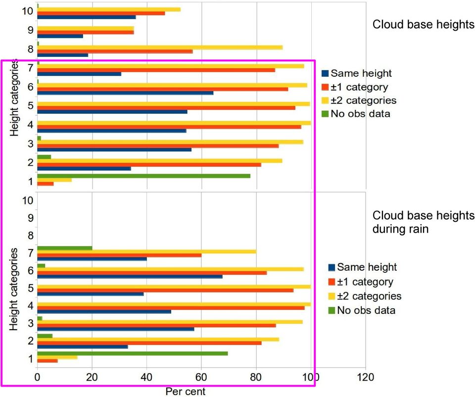
11 Cloud base height (m) compared Heights: <50, , , , , , , , , >2500 Height categories Same height ±1 category ±2 categories No obs data Per cent (%)

12 Cloud base height compared: High altitude and clear sky discrepancies Total data distribution: Same height 39%, within ±1 category 67%, within ±2 categories 76%. The ceilometer is doing a point measurement to find the base cloud height. The observer will look at the entire sky for clouds and report the altitude of the base. Also: How accurate are the observer estimates at high altitudes?

13 Is ceilometer cloud base height measurements influenced by rain? The ceilometer identifies clouds by looking for signal thresholds. Could the signal returned by heavy precipitation trick the ceilometer into reporting a cloud?

14 10 Cloud base height (m) during rain 9 8 Heights: <50, , , , , , , , , >2500 Height categories Same height ±1 category ±2 categories No obs data Per cent (%)

15 Cloud base heights Cloud base heights during rain
16 The ceilometer provides an estimate of the total cloud cover Point measurements over time are combined to provide an estimated cloud cover. This estimate is compared to the manually observed cloud cover at one point in time.

17 Total cloud cover compared Octa Octa Same cover ±1 octa ±2 octa Per cent(%)

18 Multiple scattering is used by the ceilometer to identify precip./fog High particle density produce a stronger signal than usual close to the instrument. In cases of low density precipitation or a clear area around the instrument during fog, this method will not work.

19 Ceilometer sky condition index vs weather at observation time (WW) Clear Rain Fog Snow Clear 98% 1% 0% 0% Rain 22% 74% 2% 0% Fog 29% 15% 53% 1% Snow 23% 18% 0% 57% Example: When snow is observed, the ceilometer will indicate snow 57%, rain 18% and no precip 23% of the time. However, the visual WW code used by observers can be difficult to compare to the automatic sky index.

20 Ceilometer sky index vs pluviometer (rain gauge) measurements 1min resolution pluviometer data Clear Rain Fog Snow No precip. 88% 6% 3% 2% Precipitation 5% 89% 1% 2% 1h resolution pluviometer data Clear Rain Fog Snow No precip. 99% 0% 1% 0% Precipitation 5% 86% 0% 9%

21 Ceilometer sky index and observed visibility compared Clear Rain Fog Snow Visibility > 1km 87% 8% 2% 2% Visibility < 1km 2% 10% 59% 26% Visibility can be low due to other reasons than fog (rain, snow, aerosols).
22 The agreement between ceilometer and observer is mostly good The ceilometer should not be used as the only source of information but adds valuable data. It provides high time resolution data 24/7. It provides aerosol information!
Fog and low cloud ceilings in the northeastern US: climatology and dedicated field study
 Fog and low cloud ceilings in the northeastern US: climatology and dedicated field study Robert Tardif National Center for Atmospheric Research Research Applications Laboratory 1 Overview of project Objectives:
ABSTRACT INTRODUCTION
 Observing Fog And Low Cloud With A Combination Of 78GHz Cloud Radar And Laser Met Office: Darren Lyth 1, John Nash. Rutherford Appleton Laboratory: M.Oldfield ABSTRACT Results from two demonstration tests
Introduction to the forecasting world Jukka Julkunen FMI, Aviation and military WS
 Boundary layer challenges for aviation forecaster Introduction to the forecasting world Jukka Julkunen FMI, Aviation and military WS 3.12.2012 Forecast for general public We can live with it - BUT Not
Weather Radar Basics
 Weather Radar Basics RADAR: Radio Detection And Ranging Developed during World War II as a method to detect the presence of ships and aircraft (the military considered weather targets as noise) Since WW
G. Karasinski, T. Stacewicz, S.Chudzynski, W. Skubiszak, S. Malinowski 1, A. Jagodnicka Institute of Experimental Physics, Warsaw University, Poland
 P1.7 INVESTIGATION OF ATMOSPHERIC AEROSOL WITH MULTIWAVELENGTH LIDAR G. Karasinski, T. Stacewicz, S.Chudzynski, W. Skubiszak, S. Malinowski 1, A. Jagodnicka Institute of Experimental Physics, Warsaw University,
AERODROME METEOROLOGICAL OBSERVATION AND FORECAST STUDY GROUP (AMOFSG)
") 23/12/09 AERODROME METEOROLOGICAL OBSERVATION AND FORECAST STUDY GROUP (AMOFSG) EIGHTH MEETING Melbourne, Australia, 15 to 18 February 2010 Agenda Item 5: Observing and forecasting at the aerodrome and
23/12/09 AERODROME METEOROLOGICAL OBSERVATION AND FORECAST STUDY GROUP (AMOFSG) EIGHTH MEETING Melbourne, Australia, 15 to 18 February 2010 Agenda Item 5: Observing and forecasting at the aerodrome and
Electromagnetic Radiation (EMR) and Remote Sensing
 and Remote Sensing") Electromagnetic Radiation (EMR) and Remote Sensing 1 Atmosphere Anything missing in between? Electromagnetic Radiation (EMR) is radiated by atomic particles at the source (the Sun), propagates through
Electromagnetic Radiation (EMR) and Remote Sensing 1 Atmosphere Anything missing in between? Electromagnetic Radiation (EMR) is radiated by atomic particles at the source (the Sun), propagates through
A climatology of cirrus clouds from ground-based lidar measurements over Lille
 A climatology of cirrus clouds from ground-based lidar measurements over Lille Rita Nohra, Frédéric Parol, Philippe Dubuisson Laboratoire d Optique Atmosphérique université de Lille, CNRS UMR 8518 Objectives
Evaluations of the CALIPSO Cloud Optical Depth Algorithm Through Comparisons with a GOES Derived Cloud Analysis
 Generated using V3.0 of the official AMS LATEX template Evaluations of the CALIPSO Cloud Optical Depth Algorithm Through Comparisons with a GOES Derived Cloud Analysis Katie Carbonari, Heather Kiley, and
Passive and Active Microwave Remote Sensing of Cold-Cloud Precipitation : Wakasa Bay Field Campaign 2003
 Passive and Active Microwave Remote Sensing of Cold-Cloud Precipitation : Wakasa Bay Field Campaign 3 Benjamin T. Johnson,, Gail Skofronick-Jackson 3, Jim Wang 3, Grant Petty jbenjam@neptune.gsfc.nasa.gov
Diurnal Cycle: Cloud Base Height clear sky
 Diurnal Cycle: Cloud Base Height clear sky Helsinki CNN I Madrid, 16 Dezember 2002 1 Cabauw Geesthacht Cabauw Geesthacht Helsinki Helsinki Petersburg Potsdam Petersburg Potsdam CNN I CNN II Madrid, 16
Glaciogenic Cloud Seeding to Increase Orographic Precipitation Bruce A. Boe bboe@weathermod.com Director of Meteorology
 Glaciogenic Cloud Seeding to Increase Orographic Precipitation Bruce A. Boe bboe@weathermod.com Director of Meteorology Weather Modification, Inc. Fargo, North Dakota, USA www.weathermodification.com Content
[7] SD3.1 The student demonstrates an understanding of cycles influenced by energy from the
![[7] SD3.1 The student demonstrates an understanding of cycles influenced by energy from the](/thumbs/27/12373649.jpg "[7] SD3.1 The student demonstrates an understanding of cycles influenced by energy from the") Cloud Types Levels Overview: During this project, students learn about different types of clouds and determine which type of cloud is most commonly overhead in their area over a period of four weeks. Objectives:
Cloud Types Levels Overview: During this project, students learn about different types of clouds and determine which type of cloud is most commonly overhead in their area over a period of four weeks. Objectives:
Education and Outreach Lesson Plan
 Education and Outreach Lesson Plan Visit our online activities collection http://education.arm.gov/ Grade levels K 2 Common Covering Clouds Common Covering Clouds Approximate Time 1 1/2 hours, or two 45-minute
4.12 Improving wind profiler data recovery in non-uniform precipitation using a modified consensus algorithm
 4.12 Improving wind profiler data recovery in non-uniform precipitation using a modified consensus algorithm Raisa Lehtinen 1, Daniel Gottas 2, Jim Jordan 3, Allen White 2 1 Vaisala Inc, Boulder, Colorado,
Safe Operating Procedure
 Safe Operating Procedure (Revised 11/11) OPACITY OF EMISSIONS FROM COMBUSTION SOURCES (For assistance, please contact EHS at (402) 472-4925, or visit our web site at http://ehs.unl.edu/) The University
Fog and Cloud Development. Bows and Flows of Angel Hair
 Fog and Cloud Development Bows and Flows of Angel Hair 1 Ch. 5: Condensation Achieving Saturation Evaporation Cooling of Air Adiabatic and Diabatic Processes Lapse Rates Condensation Condensation Nuclei
Big Data Assimilation Revolutionizing Weather Prediction
 February 23, 2015, ISDA2015, Kobe Big Data Assimilation Revolutionizing Weather Prediction M. Kunii, J. Ruiz, G.-Y. Lien, K. Kondo, S. Otsuka, Y. Maejima, and Takemasa Miyoshi* RIKEN Advanced Institute
Verification of cloud simulation in HARMONIE AROME
 METCOOP MEMO No. 01, 2013 Verification of cloud simulation in HARMONIE AROME A closer look at cloud cover, cloud base and fog in AROME Karl-Ivar Ivarsson, Morten Køltzow, Solfrid Agersten Front: Low fog
Measurement of the effect of biomass burning aerosol on inhibition of cloud formation over the Amazon
 Supporting Online Material for Koren et al. Measurement of the effect of biomass burning aerosol on inhibition of cloud formation over the Amazon 1. MODIS new cloud detection algorithm The operational
Name: Date: LAB: Dew Point and Cloud Formation Adapted from Exploration in Earth Science, The Physical Setting, United Publishing Company, Inc.
 Name: _ Date: LAB: Dew Point and Cloud Formation Adapted from Exploration in Earth Science, The Physical Setting, United Publishing Company, Inc. Introduction: Cumulus clouds are our puffy fair weather
Stability and Cloud Development. Stability in the atmosphere AT350. Why did this cloud form, whereas the sky was clear 4 hours ago?
 Stability and Cloud Development AT350 Why did this cloud form, whereas the sky was clear 4 hours ago? Stability in the atmosphere An Initial Perturbation Stable Unstable Neutral If an air parcel is displaced
Precipitation Remote Sensing
 Precipitation Remote Sensing Huade Guan Prepared for Remote Sensing class Earth & Environmental Science University of Texas at San Antonio November 14, 2005 Outline Background Remote sensing technique
Active and Passive Microwave Remote Sensing
 Active and Passive Microwave Remote Sensing Passive remote sensing system record EMR that was reflected (e.g., blue, green, red, and near IR) or emitted (e.g., thermal IR) from the surface of the Earth.
VALIDATION OF SAFNWC / MSG CLOUD PRODUCTS WITH ONE YEAR OF SEVIRI DATA
 VALIDATION OF SAFNWC / MSG CLOUD PRODUCTS WITH ONE YEAR OF SEVIRI DATA M.Derrien 1, H.Le Gléau 1, Jean-François Daloze 2, Martial Haeffelin 2 1 Météo-France / DP / Centre de Météorologie Spatiale. BP 50747.
Clouds and the Energy Cycle
 August 1999 NF-207 The Earth Science Enterprise Series These articles discuss Earth's many dynamic processes and their interactions Clouds and the Energy Cycle he study of clouds, where they occur, and
Parameterization of Cumulus Convective Cloud Systems in Mesoscale Forecast Models
 DISTRIBUTION STATEMENT A. Approved for public release; distribution is unlimited. Parameterization of Cumulus Convective Cloud Systems in Mesoscale Forecast Models Yefim L. Kogan Cooperative Institute
Winds. Winds on a weather map are represented by wind barbs; e.g., Notes:
 Winds Winds on a weather map are represented by wind barbs; e.g., flag half flag pennant wind direction The wind is blowing from the side with the flags and pennants (think an arrow with feathers) Speeds
Weather Help - NEXRAD Radar Maps. Base Reflectivity
 Weather Help - NEXRAD Radar Maps Base Reflectivity Base Reflectivity Severe Thunderstorm/Torna do Watch Areas 16 levels depicted with colors from dark green (very light) to red (extreme) that indicate
Cloud Profiling at the Lindenberg Observatory
 Cloud Profiling at the Lindenberg Observatory Ulrich Görsdorf DWD, Cloud Profiling with a Ka-Band radar at the Lindenberg Observatory Ulrich Görsdorf DWD, MIRA 35.5 GHz (8 mm) Radar (Ka-Band) Coherent
Clouds and What They Mean
 Vocabulary and Writing Worksheet 1. Choose the best vocabulary word for each sentence and write it in the blank. dew point evaporation fog gas precipitation relative humidity a. Relative humidity refers
Activity 4 Clouds Over Your Head Level 1
 Activity 4 Clouds Over Your Head Level 1 1 Objectives: Students will become familiar with the four main types of clouds: stratus, cirrus, cumulus, and cumulonimbus and their characteristics. Students will
 Chapter 6 Atmospheric Aerosol and Cloud Processes Spring 2015 Cloud Physics Initiation and development of cloud droplets Special interest: Explain how droplet formation results in rain in approximately
REMOTE SENSING OF CLOUD-AEROSOL RADIATIVE EFFECTS FROM SATELLITE DATA: A CASE STUDY OVER THE SOUTH OF PORTUGAL
 REMOTE SENSING OF CLOUD-AEROSOL RADIATIVE EFFECTS FROM SATELLITE DATA: A CASE STUDY OVER THE SOUTH OF PORTUGAL D. Santos (1), M. J. Costa (1,2), D. Bortoli (1,3) and A. M. Silva (1,2) (1) Évora Geophysics
Read and study the following information. After reading complete the review questions. Clouds
 Name: Pd: Read and study the following information. After reading complete the review questions. Clouds What are clouds? A cloud is a large collection of very tiny droplets of water or ice crystals. The
Technical Bulletin. Threshold and Analysis of Small Particles on the BD Accuri C6 Flow Cytometer
 Threshold and Analysis of Small Particles on the BD Accuri C6 Flow Cytometer Contents 2 Thresholds 2 Setting the Threshold When analyzing small particles, defined as particles smaller than 3.0 µm, on the
The Clouds Outside My Window. National Weather Service NOAA
 The Clouds Outside My Window National Weather Service NOAA The Clouds Out My Window Written and illustrated by John Jensenius My window With help from Owlie Skywarn 1 The Clouds Outside My Window Whether
Cloud Seeding over the Snowy Mountains
 Cloud Seeding over the Snowy Mountains Presentation to Alpine Resorts Sustainability Forum 1 May 2009 Topics covered by this presentation History of Cloud Seeding over the Snowy Mountains How Cloud Seeding
How To Use A Karlsruhe Doppler Lidar
 Andreas Wieser Institut für Meteorologie und Klimaforschung Forschungsbereich Troposphäre (IMK-TRO) First measurements with the new Karlsruhe Doppler Lidar June 03, 2004 Forschungszentrum Karlsruhe we
Chapter 7 Stability and Cloud Development. Atmospheric Stability
 Chapter 7 Stability and Cloud Development Atmospheric Stability 1 Cloud Development - stable environment Stable air (parcel) - vertical motion is inhibited if clouds form, they will be shallow, layered
Not all clouds are easily classified! Cloud Classification schemes. Clouds by level 9/23/15
 Cloud Classification schemes 1) classified by where they occur (for example: high, middle, low) 2) classified by amount of water content and vertical extent (thick, thin, shallow, deep) 3) classified by
Summary Report on National and Regional Projects set-up in Russian Federation to integrate different Ground-based Observing Systems
 WORLD METEOROLOGICAL ORGANIZATION COMMISSION FOR INSTRUMENT AND METHODS OF OBSERVATION OPAG-UPPER AIR EXPERT TEAM ON REMOTE SENSING UPPER-AIR TECHNOLOGY AND TECHNIQUES First Session Geneva, Switzerland,
Let s Make a Cloud. Objective Demonstrate the combination of three natural elements, to form a cloud: water vapor, smoke and air pressure.
 Let s Make a Cloud Related Subject: Climate and Weather Group Size: 10-15 Length of Activity: 45 minutes Objective Demonstrate the combination of three natural elements, to form a cloud: water vapor, smoke
A glance at compensating errors between low-level cloud fraction and cloud optical properties using satellite retrievals
 A glance at compensating errors between low-level cloud fraction and cloud optical properties using satellite retrievals Christine Nam & Sandrine Bony Laboratoire de Météorologie Dynamique Structure Overview
Make a Cloud Finder. How to Fold the Cloud Finder: Play the Weather Word Game:
 Make a Cloud Finder Make a Cloud Finder. The pattern is included here. Learn the names of the beautiful clouds that may appear in the sky where you live. Color your Cloud Finder, and cut it out on the
Nowcasting: analysis and up to 6 hours forecast
 Nowcasting: analysis and up to 6 hours forecast Very high resoultion in time and space Better than NWP Rapid update Application oriented NWP problems for 0 6 forecast: Incomplete physics Resolution space
What the Heck are Low-Cloud Feedbacks? Takanobu Yamaguchi Rachel R. McCrary Anna B. Harper
 What the Heck are Low-Cloud Feedbacks? Takanobu Yamaguchi Rachel R. McCrary Anna B. Harper IPCC Cloud feedbacks remain the largest source of uncertainty. Roadmap 1. Low cloud primer 2. Radiation and low
Changing Clouds in a Changing Climate: Anthropogenic Influences
 Changing Clouds in a Changing Climate: Anthropogenic Influences Joel Norris Assistant Professor of Climate and Atmospheric Sciences Scripps Institution of Oceanography Global mean radiative forcing of
Cloud Type and Macrophysical Property Retrieval Using Multiple Remote Sensors
 VOLUME 4 JOURNAL OF APPLIED METEOROLOGY OCTOBER 2 Cloud Type and Macrophysical Property Retrieval Using Multiple Remote Sensors ZHIEN WANG AND KENNETH SASSEN Department of Meteorology, University of Utah,
SAFNWC/MSG Cloud type/height. Application for fog/low cloud situations
 SAFNWC/MSG Cloud type/height. Application for fog/low cloud situations 22 September 2011 Hervé LE GLEAU, Marcel DERRIEN Centre de météorologie Spatiale. Lannion Météo-France 1 Fog or low level clouds?
ARM SWS to study cloud drop size within the clear-cloud transition zone
 ARM SWS to study cloud drop size within the clear-cloud transition zone (GSFC) Yuri Knyazikhin Boston University Christine Chiu University of Reading Warren Wiscombe GSFC Thanks to Peter Pilewskie (UC)
Partnerships Implementing Engineering Education Worcester Polytechnic Institute Worcester Public Schools
 Partnerships Implementing Engineering Education Worcester Polytechnic Institute Worcester Public Schools Supported by: National Science Foundation Weather: 4.H.3 Weather and Classical Instruments Grade
Full name:.. Date:. School: Teacher: Contents:
 Contents: 1.- The atmosphere. 2.- Weather and climate. 3.- The elements of climate 3.1 Temperatures 3.2 Rainfalls 3.3 Atmospheric pressure 3.4 Wind 4.-The Natural Environment. Full name:.. Date:. Class:
Basics of weather interpretation
 Basics of weather interpretation Safety at Sea Seminar, April 2 nd 2016 Dr. Gina Henderson Oceanography Dept., USNA ghenders@usna.edu Image source: http://earthobservatory.nasa.gov/naturalhazards/view.php?id=80399,
Atmosphere. Cloud Protocols. Draft 9/15/00. GLOBE 2000 Cloud Protocols - 1 Atmosphere
 Atmosphere Cloud Protocols Draft 9/15/00 GLOBE 2000 Cloud Protocols - 1 Atmosphere Cloud Protocols Purpose To observe cloud type and cover Student Outcomes Students learn how to make estimates from observations
Clouds, Fog, & Precipitation
 firecatching.blogspot.com Kids.brittanica.com Clouds and fog are physically the same just location is different Fog is considered a stratus cloud at or near the surface What does one see when looking at
Outline of RGB Composite Imagery
 Outline of RGB Composite Imagery Data Processing Division, Data Processing Department Meteorological Satellite Center (MSC) JMA Akihiro SHIMIZU 29 September, 2014 Updated 6 July, 2015 1 Contents What s
Cloud seeding. Frequently Asked Questions. What are clouds and how are they formed? How do we know cloud seeding works in Tasmania?
 What are clouds and how are they formed? Clouds are composed of water droplets and sometimes ice crystals. Clouds form when air that is rich in moisture near the Earth s surface rises higher into the atmosphere,
IBM Big Green Innovations Environmental R&D and Services
 IBM Big Green Innovations Environmental R&D and Services Smart Weather Modelling Local Area Precision Forecasting for Weather-Sensitive Business Operations (e.g. Smart Grids) Lloyd A. Treinish Project
Remote Sensing of Clouds from Polarization
 Remote Sensing of Clouds from Polarization What polarization can tell us about clouds... and what not? J. Riedi Laboratoire d'optique Atmosphérique University of Science and Technology Lille / CNRS FRANCE
Tools for Viewing and Quality Checking ARM Data
 Tools for Viewing and Quality Checking ARM Data S. Bottone and S. Moore Mission Research Corporation Santa Barbara, California Introduction Mission Research Corporation (MRC) is developing software tools
GOES-R AWG Cloud Team: ABI Cloud Height
 GOES-R AWG Cloud Team: ABI Cloud Height June 8, 2010 Presented By: Andrew Heidinger 1 1 NOAA/NESDIS/STAR 1 Outline Executive Summary Algorithm Description ADEB and IV&V Response Summary Requirements Specification
SIXTH GRADE WEATHER 1 WEEK LESSON PLANS AND ACTIVITIES
 SIXTH GRADE WEATHER 1 WEEK LESSON PLANS AND ACTIVITIES WATER CYCLE OVERVIEW OF SIXTH GRADE WATER WEEK 1. PRE: Evaluating components of the water cycle. LAB: Experimenting with porosity and permeability.
CHAPTER 5 - SKY CONDITION
 CHAPTER 5 SKY CONDITION ADDITIONAL MATERIAL TO STUDY: Chapter 9, paragraphs 9.2.1g & h, ceiling and sky condition criteria for SPECI. 5.1 Introduction This chapter provides information on sky condition
Meteorological SPACE WEATHER SPECIAL! BRITISH ANTARCTIC SURVEY The meteorological capabilities and work of the BAS explained
 THE INTERNATIONAL REVIEW OF WEATHER, CLIMATE AND HYDROLOGY TECHNOLOGIES AND SERVICES Meteorological T E C H N O L O G Y I N T E R N A T I O N A L SPACE WEATHER SPECIAL! Exclusive interview with the UK
Cloud-Resolving Simulations of Convection during DYNAMO
 Cloud-Resolving Simulations of Convection during DYNAMO Matthew A. Janiga and Chidong Zhang University of Miami, RSMAS 2013 Fall ASR Workshop Outline Overview of observations. Methodology. Simulation results.
Clouds. A simple scientific explanation for the weather-curious. By Kira R. Erickson
 Clouds A simple scientific explanation for the weather-curious By Kira R. Erickson Table of Contents 1 3 4 INTRO 2 Page 3 How Clouds Are Formed Types of Clouds Clouds and Weather More Information Page
TOPIC: CLOUD CLASSIFICATION
 INDIAN INSTITUTE OF TECHNOLOGY, DELHI DEPARTMENT OF ATMOSPHERIC SCIENCE ASL720: Satellite Meteorology and Remote Sensing TERM PAPER TOPIC: CLOUD CLASSIFICATION Group Members: Anil Kumar (2010ME10649) Mayank
Solar Irradiance Forecasting Using Multi-layer Cloud Tracking and Numerical Weather Prediction
 Solar Irradiance Forecasting Using Multi-layer Cloud Tracking and Numerical Weather Prediction Jin Xu, Shinjae Yoo, Dantong Yu, Dong Huang, John Heiser, Paul Kalb Solar Energy Abundant, clean, and secure
Email: tjohn@mail.nplindia.ernet.in
 USE OF VIRTUAL INSTRUMENTS IN RADIO AND ATMOSPHERIC EXPERIMENTS P.N. VIJAYAKUMAR, THOMAS JOHN AND S.C. GARG RADIO AND ATMOSPHERIC SCIENCE DIVISION, NATIONAL PHYSICAL LABORATORY, NEW DELHI 110012, INDIA
Chapter 6 - Cloud Development and Forms. Interesting Cloud
 Chapter 6 - Cloud Development and Forms Understanding Weather and Climate Aguado and Burt Interesting Cloud 1 Mechanisms that Lift Air Orographic lifting Frontal Lifting Convergence Localized convective
DATA LAYOUT AND LEVEL-OF-DETAIL CONTROL FOR FLOOD DATA VISUALIZATION
 DATA LAYOUT AND LEVEL-OF-DETAIL CONTROL FOR FLOOD DATA VISUALIZATION Sayaka Yagi Takayuki Itoh Ochanomizu University Mayumi Kurokawa Yuuichi Izu Takahisa Yoneyama Takashi Kohara Toshiba Corporation ABSTRACT
CALIPSO, CloudSat, CERES, and MODIS Merged Data Product
 CALIPSO, CloudSat, CERES, and MODIS Merged Data Product Seiji Kato 1, Sunny Sun-Mack 2, Walter F. Miller 2, Fred G. Rose 2, and Victor E. Sothcott 2 1 NASA Langley Research Center 2 Science and Systems
Temperature affects water in the air.
 KEY CONCEPT Most clouds form as air rises and cools. BEFORE, you learned Water vapor circulates from Earth to the atmosphere Warm air is less dense than cool air and tends to rise NOW, you will learn How
The impact of window size on AMV
 The impact of window size on AMV E. H. Sohn 1 and R. Borde 2 KMA 1 and EUMETSAT 2 Abstract Target size determination is subjective not only for tracking the vector but also AMV results. Smaller target
A SURVEY OF CLOUD COVER OVER MĂGURELE, ROMANIA, USING CEILOMETER AND SATELLITE DATA
 Romanian Reports in Physics, Vol. 66, No. 3, P. 812 822, 2014 ATMOSPHERE PHYSICS A SURVEY OF CLOUD COVER OVER MĂGURELE, ROMANIA, USING CEILOMETER AND SATELLITE DATA S. STEFAN, I. UNGUREANU, C. GRIGORAS
Cloud Thickness Estimation from GOES-8 Satellite Data Over the ARM-SGP Site
 Cloud Thickness Estimation from GOES-8 Satellite Data Over the ARM-SGP Site V. Chakrapani, D. R. Doelling, and A. D. Rapp Analytical Services and Materials, Inc. Hampton, Virginia P. Minnis National Aeronautics
ASOS GUIDE FOR PILOTS
 ASOS GUIDE FOR PILOTS INTRODUCTION... 1 NOTICES TO AIRMEN... 1 SYSTEM DESCRIPTION... 2 WEATHER OBSERVATION ELEMENTS... 3 DATA NOT AUTOMATICALLY PROVIDED BY ASOS... 7 MISSING DATA AND NON EVENT DATA...
Clouds/WX Codes. B.1 Introduction
 Clouds/WX Codes B.1 Introduction This appendix provides the necessary tables and specific instructions to enter Clouds/Wx at the Surface Data screen. This guidance assumes no previous knowledge of synoptic
LiDAR for vegetation applications
 LiDAR for vegetation applications UoL MSc Remote Sensing Dr Lewis plewis@geog.ucl.ac.uk Introduction Introduction to LiDAR RS for vegetation Review instruments and observational concepts Discuss applications
German Test Station for Remote Wind Sensing Devices
 German Test Station for Remote Wind Sensing Devices A. Albers, A.W. Janssen, J. Mander Deutsche WindGuard Consulting GmbH, Oldenburger Straße, D-31 Varel, Germany E-mail: a.albers@windguard.de, Tel: (++9)
Formation & Classification
 CLOUDS Formation & Classification DR. K. K. CHANDRA Department of forestry, Wildlife & Environmental Sciences, GGV, Bilaspur What is Cloud It is mass of tiny water droplets or ice crystals or both of size
ROAD WEATHER AND WINTER MAINTENANCE
 Road Traffic Technology ROAD WEATHER AND WINTER MAINTENANCE METIS SSWM WMi ROAD WEATHER STATIONS ADVANCED ROAD WEATHER INFORMATION SYSTEM MAINTENANCE DECISION SUPPORT SYSTEM WINTER MAINTENANCE PERFORMANCE
a) species of plants that require a relatively cool, moist environment tend to grow on poleward-facing slopes.
 species of plants that require a relatively cool, moist environment tend to grow on poleward-facing slopes.") J.D. McAlpine ATMS 611 HMWK #8 a) species of plants that require a relatively cool, moist environment tend to grow on poleward-facing slopes. These sides of the slopes will tend to have less average solar
J.D. McAlpine ATMS 611 HMWK #8 a) species of plants that require a relatively cool, moist environment tend to grow on poleward-facing slopes. These sides of the slopes will tend to have less average solar
If wispy, no significant icing or turbulence. If dense or in bands turbulence is likely. Nil icing risk. Cirrocumulus (CC)
") Cirrus (CI) Detached clouds in the form of delicate white filaments or white patches or narrow bands. These clouds have a fibrous or hair like appearance, or a silky sheen or both. with frontal lifting
Cirrus (CI) Detached clouds in the form of delicate white filaments or white patches or narrow bands. These clouds have a fibrous or hair like appearance, or a silky sheen or both. with frontal lifting
YEAR 1: Seasons and Weather
 YEAR 1: Seasons and Weather Contents Include: The four seasons Tools to record the weather Making graphs Clouds Weather forecasts Weather around the world Please Note: The activities included in this pack
3D Building Roof Extraction From LiDAR Data
 3D Building Roof Extraction From LiDAR Data Amit A. Kokje Susan Jones NSG- NZ Outline LiDAR: Basics LiDAR Feature Extraction (Features and Limitations) LiDAR Roof extraction (Workflow, parameters, results)
Evaluation of the Nubiscope
 Technical report; TR-291 Evaluation of the Nubiscope Wiel Wauben De Bilt, 2006 KNMI Technical report = technisch rapport; TR-291 De Bilt, 2006 PO Box 201 3730 AE De Bilt Wilhelminalaan 10 De Bilt The Netherlands
Group Session 1-3 Rain and Cloud Observations
 Group Session 1-3 Rain and Cloud Observations Targets in Science Plans CINDY Science Plan (Apr. 2009) DYNAMO SPO (Jul. 2009) Atmospheric Research a. Preconditioning processes b. Rossby wave c. Diabatic
Recent activities on Big Data Assimilation in Japan
 August 17, 2014, WWOSC, Montreal, Canada Recent activities on Big Data Assimilation in Japan M. Kunii, J. Ruiz, K. Kondo, and Takemasa Miyoshi* RIKEN Advanced Institute for Computational Science *PI and
Name: OBJECTIVES Correctly define: WEATHER BASICS: STATION MODELS: MOISTURE: PRESSURE AND WIND: Weather
 Name: OBJECTIVES Correctly define: air mass, air pressure, anemometer, barometer, cyclone, dew point, front, isobar, isotherm, meteorology, precipitation, psychrometer, relative humidity, saturated, transpiration
CHAPTER 5 Lectures 10 & 11 Air Temperature and Air Temperature Cycles
 CHAPTER 5 Lectures 10 & 11 Air Temperature and Air Temperature Cycles I. Air Temperature: Five important factors influence air temperature: A. Insolation B. Latitude C. Surface types D. Coastal vs. interior
Estimating Firn Emissivity, from 1994 to1998, at the Ski Hi Automatic Weather Station on the West Antarctic Ice Sheet Using Passive Microwave Data
 Estimating Firn Emissivity, from 1994 to1998, at the Ski Hi Automatic Weather Station on the West Antarctic Ice Sheet Using Passive Microwave Data Mentor: Dr. Malcolm LeCompte Elizabeth City State University
BECAUSE WEATHER MATTERS UBIMET
 UBIMET Weather Information and Alert Systems for Railroads UBIMET because weather matters One of the largest private weather services in Europe Provides severe weather warnings for more than 1 million
GROUND VISIBILITY AND CLOUD COVERAGE ESTIMATION FOR AIR ROUTE MONITORING ON MOUNTAINOUS AREA
 GROUND VISIBILITY AND CLOUD COVERAGE ESTIMATION FOR AIR ROUTE MONITORING ON MOUNTAINOUS AREA Asamaporn Sitthi a *, Masahiko NAGAI a and Kiyoshi HONDA b a Remote Sensing and Geographic Information Systems
In a majority of ice-crystal icing engine events, convective weather occurs in a very warm, moist, tropical-like environment. aero quarterly qtr_01 10
 In a majority of ice-crystal icing engine events, convective weather occurs in a very warm, moist, tropical-like environment. 22 avoiding convective Weather linked to Ice-crystal Icing engine events understanding
CHAPTER 6 INSTRUMENTATION AND MEASUREMENTS 6.1 MEASUREMENTS
 CHAPTER 6 INSTRUMENTATION AND MEASUREMENTS 6.1 MEASUREMENTS Atmospheric electricity is a field that is very easy to get into because it does not require a large capital investment for measuring equipment.
Cloud Development and Forms. LIFTING MECHANISMS 1. Orographic 2. Frontal 3. Convergence 4. Convection. Orographic Cloud. The Orographic Cloud
 Introduction to Climatology GEOGRAPHY 300 Cloud Development and Forms Tom Giambelluca University of Hawai i at Mānoa LIFTING MECHANISMS 1. Orographic 2. Frontal 3. Convergence 4. Convection Cloud Development
Application of Numerical Weather Prediction Models for Drought Monitoring. Gregor Gregorič Jožef Roškar Environmental Agency of Slovenia
 Application of Numerical Weather Prediction Models for Drought Monitoring Gregor Gregorič Jožef Roškar Environmental Agency of Slovenia Contents 1. Introduction 2. Numerical Weather Prediction Models -
STATUS OF THE AUTOMATIC OBSERVATION ON AERODROME AND ONGOING IMPROVEMENTS IN FRANCE
 1/8 STATUS OF THE AUTOMATIC OBSERVATION ON AERODROME AND ONGOING IMPROVEMENTS IN FRANCE Michel Leroy Météo-France, BP202, 78195 Trappes Cedex, France Tel : +33 130135405 Fax : +33 130136020 michel.leroy@meteo.fr