Big Data Assimilation Revolutionizing Weather Prediction
|
|
|
- Rosemary Cooper
- 8 years ago
- Views:
Transcription
1 February 23, 2015, ISDA2015, Kobe Big Data Assimilation Revolutionizing Weather Prediction M. Kunii, J. Ruiz, G.-Y. Lien, K. Kondo, S. Otsuka, Y. Maejima, and Takemasa Miyoshi* RIKEN Advanced Institute for Computational Science *PI and presenting, S. Satoh, T. Ushio, H. Tomita, Y. Ishikawa, K. Bessho, H. Seko

2 Data Assimilation (DA) Observations Numerical models Data Assimilation Vaisala Data assimilation best combines observations and a model, and brings synergy.

3 Data Assimilation (DA) Observations Numerical models Data Assimilation >2

4 Numerical Weather Prediction An example of synchronizing chaos Forecast Forecast Model Simulation Analysis Observation Analysis Analysis Observation True atmosphere (Unknown) time

5 We consider the evolution of PDF Analysis ensemble mean R Obs. Analysis w/ errors FCST ensemble mean T=t0 T=t1 T=t2

6 Global 870-m simulation (Miyamoto et al. 2013) JAMSTEC AORI (SPIRE Field3), RIKEN/AICS Visualized by Ryuji Yoshida
, RIKEN/AICS")
7 Computers getting more powerful With the post-k supercomputer (~2020), we can afford 100 members of global 870-m simulation. Or a larger ensemble at a lower resolution? The Japanese 10-Peta-Flops K computer

8

9

10 Advantage of large ensemble 100 members (Miyoshi, Kondo, Imamura 2014) members Sampling noise reduced High-precision probabilistic representation Cf. P-26 Kondo, Tue

11 Toward next 20 years of DA Big Data Assimilation Era Exploding data Courtesy of S. Shima Big Data Enabling effective use Big Data High-resolution simulation More computational power High-resolution obs Advanced obs technology

12 Next-generation geostationary satellite Himawari-8 was launched successfully on 7 October Himawari-9 will be launched in Super Rapid Scan every 30 seconds Full Disk 10 min. 2.5 min. Rapid Scan 30 sec. Super Rapid Scan (Courtesy of JMA)

13 Rapid scan effective for convections Typical lifetime of a convective system ~30 min. Satellite imagery captures developing convections. Chisholm, A. J. and Renick, J. H. (1972) Radar captures rain particles after the developing stage. (may be too late )

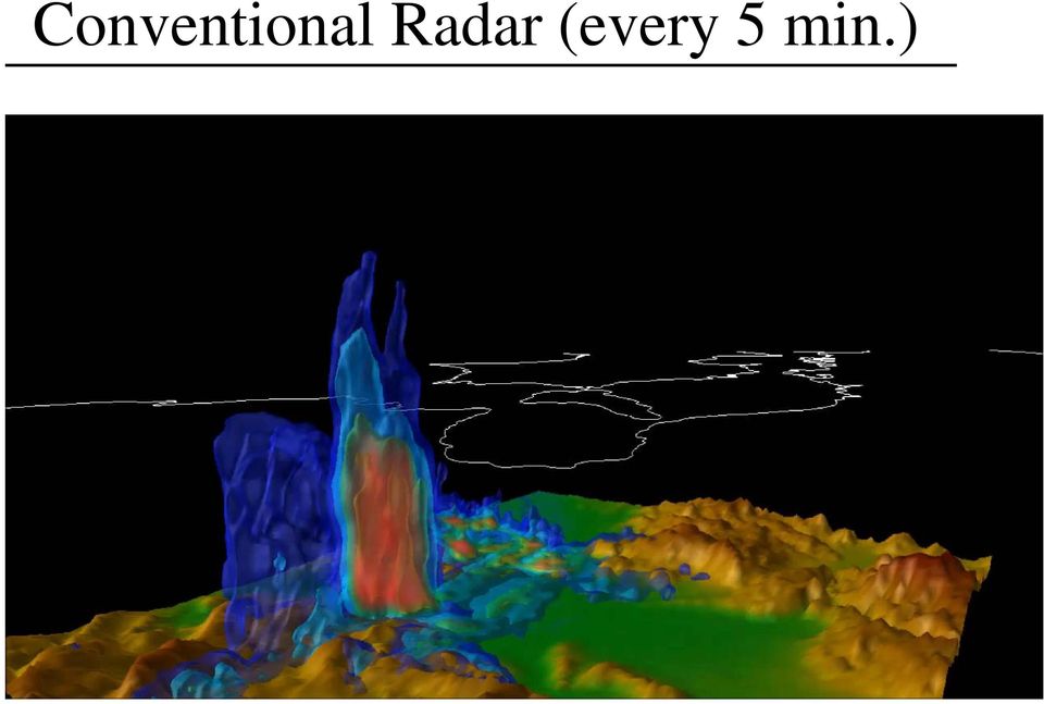
14 Phased Array Radar (courtesy of NICT) Conventional Radar ~15 scan angles Every 5-10 minutes Phased Array Radar ~100 scan angles Every seconds

15 Conventional Radar (every 5 min.)
16 Phased Array Radar (every 30 sec.)

17 Two PAR in Kobe area NICT Kobe r = 60 km KOBE Osaka Univ.

18 Exploring new data: live-camera images? 1. Reduced/extracted information (e.g., weather type, visibility) (challenge) Automated image processing 2. Simulating images from model outputs (challenge) precise 3-dimensional radiation model

19 Towards Big Data Assimilation High-resolution simulation Combination of next-generation technologies Big Data Assimilation Improving simulations High-resolution observation

20 Storm forecasting with Big Data Assimilation 5 people died in Kobe on July 28, 2008, due to local heavy rainfall Just in 10 min. Goal: 30-min forecasting of local severe weather through Big Data Assimilation innovations.

21 Revolutionary super-rapid 30-sec. cycle Obs data processing ~2GB Obs data processing ~2GB DA (2PFLOP) 380GB 3GB 30-sec. Ensemble forecasting (2PFLOP) 2.5TB DA (2PFLOP) 30-min. forecasting (1.2PFLOP) 380GB 3GB 30-sec. Ensemble forecasting (2PFLOP) 2.5TB D (2PF 30-min. forecasting (1.2PFL Time (sec.) Computing requirement: 250TFLOPS (effective) Equiv. to 1/4 of the K computer 120 times more rapid than the hourly Rapid Refresh
22 A case selected for the first offline study The top page of Yomiuri newspaper on 14 July, 2013
23 Phased Array Radar (2013/7/13, 14:00 16:20 KYOTO Mt IKOMA NARA OSAKA Mt ROKKO KOBE OSAKA BAY 10fps 300x 23
24 30-sec. and 5-min. evolutions (Miyoshi et al. 2015) 5 min 30 sec nonlinear evolution linear evolution
25 Impact of Big Data Assimilation 15:00:30 JST after the first assimilation NO DA WITH DA Observation 15:06:00 JST after the 12th assimilation NO DA WITH DA Observation
26 Vertical section NO DA 15:06:00 JST WITH DA Observation
27 Thermodynamic structure 15:06:00 JST
28 Forecasts 10-min. 15:06:00 JST 15:16:00 JST NO DA WITH DA Observation 20-min. 15:06:00 JST 15:26:00 JST
29 RMS Errors
30 Toward seamless prediction t=0 t=10 min. t=20 min. Nowcasting Convection model (adopted from JMA webpage) A nowcasting system taking advantage of the dense/frequent PAWR data is explored.
31 Making sense of Big Data for local severe storms: Real time processing of three dimensional 30 second update radar data AICS HPC Internship program S. Otsuka, G. Tuerhong, J. Ruiz, and T. Miyoshi Data Assimilation Research Team Intern students: R. Kikuchi (Tohoku Univ.), Y. Kitano (Hokkaido Univ.), and Y. Taniguchi (Univ. of Hyogo) CREST Big Data Assimilation project: H. Tomita, H. Seko, K. Bessho, S. Satoh, T. Ushio, and Y. Ishikawa
32 AICS HPC Internship program 2014 Three intern students from 8/29 to 9/19 R. Kikuchi (Tohoku Univ.) Y. Kitano (Hokkaido Univ.) Y. Taniguchi (Univ. of Hyogo) Kitano Kikuchi Taniguchi
33 A nowcasting system using PAWR Fully utilize the new vertically dense and super rapid PAWR 100 m horizontal, 100 level vertical resolutions 30 second time resolution PAWR can capture high precision 3D rain motion High precision forecasts with a few minute lead Purely based on PAWR data
34 2D vs. 3D 3D motion extrapolation Pure image processing (a.k.a. optical flow) Rain echo in the sky Detecting motion Extrapolation Rain t = t 0 2 t = t 0 1 t = t 0 (Now) t = t (Future)
35 A real case: sky to the ground in 10 min. 17:30:16 17:32:16 17:34:16 17:36:16 17:38:16 17:40:16 17:42:16 17:44:16 10 km ( 高 度 ) 35
36 An idealized case: simulated rain Intensifying Intensifying Not intensifying (Otsuka et al. 2015)
37 Vertical cross sections Falling from sky (Otsuka et al. 2015)
38 Threat scores 3D is better than 2D! (Otsuka et al. 2015)
39 With the real Phased Array Radar observed 90-sec forecasts (Otsuka et al. 2015)
40 Predictability explored with Bred Vectors (Otsuka and Miyoshi 2015) To understand the 30-sec. updates meteorologically (Kalnay, 2003) Insights in meteorology O(sec.) O(min.)
41 BV norm evolution (θ [K], z = 5 km) rescaled 5 min. (Otsuka and Miyoshi 2015) rescaled 1 min. 0.1 rescaled 30 sec min 30min 60min
42 Vertical structure of BV (θ) 30 second breeding cycle (Otsuka and Miyoshi 2015)
43 Different breeding intervals (Otsuka and Miyoshi 2015) 30 seconds 1 minute Temp. bred vectors at 5 km 5 minutes Vertical winds
44 Perturbations in the free run 0:10:00 0:15:00 (Otsuka and Miyoshi 2015) 0.4 rms θ :00 15:00 Time
45 Exploring dense surface observations (Maejima et al. 2015) POTEKAⅡ by Meisei Electric (on the roof of RIKEN AICS) Kobe city elementary schools 8 stations implemented
46 OSSE performed (a) PAWR only (Maejima et al. 2015) 1-km resolution, 1 min cycle. Rain analysis after 50 cycles. (b) 8points of ground data (c) 167points of ground data (d) Nature run
47 Dense/frequent ground data impact (167 stations) (Maejima et al. 2015)
48 Future perspectives Explore a 30-sec. super-rapid DA cycle thorough innovating the Big Data Assimilation technology. Funded by Japanese post-k supercomputer planned in 2020 May Tokyo 2020 be a good place to demonstrate?
Recent activities on Big Data Assimilation in Japan
 August 17, 2014, WWOSC, Montreal, Canada Recent activities on Big Data Assimilation in Japan M. Kunii, J. Ruiz, K. Kondo, and Takemasa Miyoshi* RIKEN Advanced Institute for Computational Science *PI and
High Performance Computing Infrastructure in JAPAN
 High Performance Computing Infrastructure in JAPAN Yutaka Ishikawa Director of Information Technology Center Professor of Computer Science Department University of Tokyo Leader of System Software Research
RAPIDS Operational Blending of Nowcasting and NWP QPF
 RAPIDS Operational Blending of Nowcasting and NWP QPF Wai-kin Wong and Edwin ST Lai Hong Kong Observatory The Second International Symposium on Quantitative Precipitation Forecasting and Hydrology 5-8
Comparison of visual observations and automated ceilometer cloud reports at Blindern, Oslo. Anette Lauen Borg Remote sensing MET-Norway
 Comparison of visual observations and automated ceilometer cloud reports at Blindern, Oslo Anette Lauen Borg Remote sensing MET-Norway A test of our ceilometer data To fully exploit our new ceilometer
Nowcasting: analysis and up to 6 hours forecast
 Nowcasting: analysis and up to 6 hours forecast Very high resoultion in time and space Better than NWP Rapid update Application oriented NWP problems for 0 6 forecast: Incomplete physics Resolution space
Meteorological Forecasting of DNI, clouds and aerosols
 Meteorological Forecasting of DNI, clouds and aerosols DNICast 1st End-User Workshop, Madrid, 2014-05-07 Heiner Körnich (SMHI), Jan Remund (Meteotest), Marion Schroedter-Homscheidt (DLR) Overview What
Hybrid-DA in NWP. Experience at the Met Office and elsewhere. GODAE OceanView DA Task Team. Andrew Lorenc, Met Office, Exeter.
 Hybrid-DA in NWP Experience at the Met Office and elsewhere GODAE OceanView DA Task Team Andrew Lorenc, Met Office, Exeter. 21 May 2015 Crown copyright Met Office Recent History of DA for NWP 4DVar was
Weather Radar Basics
 Weather Radar Basics RADAR: Radio Detection And Ranging Developed during World War II as a method to detect the presence of ships and aircraft (the military considered weather targets as noise) Since WW
Partnership to Improve Solar Power Forecasting
 Partnership to Improve Solar Power Forecasting Venue: EUPVSEC, Paris France Presenter: Dr. Manajit Sengupta Date: October 1 st 2013 NREL is a national laboratory of the U.S. Department of Energy, Office
ICAO Developments (Hazardous Weather Information)
") ICAO Developments (Hazardous Weather Information) USER NEEDS AND EXPECTATION IATA s viewpoint Harmonized information about hazardous meteorological conditions that may constrain operations along intended
ICAO Developments (Hazardous Weather Information) USER NEEDS AND EXPECTATION IATA s viewpoint Harmonized information about hazardous meteorological conditions that may constrain operations along intended
NOWCASTING OF PRECIPITATION Isztar Zawadzki* McGill University, Montreal, Canada
 NOWCASTING OF PRECIPITATION Isztar Zawadzki* McGill University, Montreal, Canada 1. INTRODUCTION Short-term methods of precipitation nowcasting range from the simple use of regional numerical forecasts
RPG MWR PRO TN03 2012 09 Page 1 / 12 www.radiometer physics.de Radiometer Physics GmbH +49 2225 99981 0
 Applications Tropospheric profiling of temperature, humidity and liquid water High resolution boundary layer temperature profiles, better resolution than balloons Input for weather and climate models (data
e-infrastructure of DIAS
 e-infrastructure of DIAS Toshihiro Nemoto 1 Masaru Kitsuregawa 2 1 Earth Observation Data Integration and Fusion Initiative, The Univ. of Tokyo 2 Director General of National Institute of Informatics(NII)
Japan Meteorological Business Support Center (JMBSC)
") Japan Meteorological Business Support Center (JMBSC) The Japan Meteorological Business Support Center (JMBSC) is a general incorporated foundation* inaugurated in 1994, in accordance with the Meteorological
Japan Meteorological Business Support Center (JMBSC) The Japan Meteorological Business Support Center (JMBSC) is a general incorporated foundation* inaugurated in 1994, in accordance with the Meteorological
Overview of the IR channels and their applications
 Ján Kaňák Slovak Hydrometeorological Institute Jan.kanak@shmu.sk Overview of the IR channels and their applications EUMeTrain, 14 June 2011 Ján Kaňák, SHMÚ 1 Basics in satellite Infrared image interpretation
Advances in data assimilation techniques
 Advances in data assimilation techniques and their relevance to satellite data assimilation ECMWF Seminar on Use of Satellite Observations in NWP Andrew Lorenc,, 8-12 September 2014. Crown copyright Met
The K computer: Project overview
 The Next-Generation Supercomputer The K computer: Project overview SHOJI, Fumiyoshi Next-Generation Supercomputer R&D Center, RIKEN The K computer Outline Project Overview System Configuration of the K
IBM Big Green Innovations Environmental R&D and Services
 IBM Big Green Innovations Environmental R&D and Services Smart Weather Modelling Local Area Precision Forecasting for Weather-Sensitive Business Operations (e.g. Smart Grids) Lloyd A. Treinish Project
TCC News 1 No. 33 Summer 2013
 No. 33 Summer 2013 Contents Page Urban Heat Island Effect Enhancement caused by Hot Summer Conditions Summary of Kosa (Aeolian dust) Events over Japan in 2013 Sea Ice in the Sea of Okhotsk for the 2012/2013
WxFUSION. A. Tafferner. Folie 1. iport Meeting 13.10.2010 @ DLR OP
 WxFUSION A. Tafferner iport Meeting 13.10.2010 @ DLR OP Folie 1 Upper Danube Catchment MUC DLR Andechs Munich Vienna Folie 2 Local and propagating thunderstorms in the Upper Danube Catchment B. Barternschlager,
Gfarm: Present Status and Future Evolution
 OpenSFS APAC Lustre User Group 2013 Tokyo October 17, 2013 Gfarm: Present Status and Future Evolution Osamu Tatebe University of Tsukuba Gfarm file system Award-winning file system since 2000 Distributed
GCMs with Implicit and Explicit cloudrain processes for simulation of extreme precipitation frequency
 GCMs with Implicit and Explicit cloudrain processes for simulation of extreme precipitation frequency In Sik Kang Seoul National University Young Min Yang (UH) and Wei Kuo Tao (GSFC) Content 1. Conventional
Triple eyewall experiment of the 2012 typhoon Bolaven using cloud resolving ensemble forecast
 The 3 rd Research meeting of Ultrahigh Precision Meso Scale Weather Prediction Thu. 21 Mar. 2013 Triple eyewall experiment of the 2012 typhoon Bolaven using cloud resolving ensemble forecast Seiji ORIGUCHI,
Data-analysis scheme and infrastructure at the X-ray free electron laser facility, SACLA
 Data-analysis scheme and infrastructure at the X-ray free electron laser facility, SACLA T. Sugimoto, T. Abe, Y. Joti, T. Kameshima, K. Okada, M. Yamaga, R. Tanaka (Japan Synchrotron Radiation Research
Distributed Computing. Mark Govett Global Systems Division
 Distributed Computing Mark Govett Global Systems Division Modeling Activities Prediction & Research Weather forecasts, climate prediction, earth system science Observing Systems Denial experiments Observing
FLOODALERT: A SIMPLIFIED RADAR-BASED EWS FOR URBAN FLOOD WARNING
 11 th International Conference on Hydroinformatics HIC 2014, New York City, USA FLOODALERT: A SIMPLIFIED RADAR-BASED EWS FOR URBAN FLOOD WARNING XAVIER LLORT (1), RAFAEL SÁNCHEZ-DIEZMA (1), ÁLVARO RODRÍGUEZ
Sub-grid cloud parametrization issues in Met Office Unified Model
 Sub-grid cloud parametrization issues in Met Office Unified Model Cyril Morcrette Workshop on Parametrization of clouds and precipitation across model resolutions, ECMWF, Reading, November 2012 Table of
Traffic Monitoring Systems. Technology and sensors
 Traffic Monitoring Systems Technology and sensors Technology Inductive loops Cameras Lidar/Ladar and laser Radar GPS etc Inductive loops Inductive loops signals Inductive loop sensor The inductance signal
Nowcasting of significant convection by application of cloud tracking algorithm to satellite and radar images
 Nowcasting of significant convection by application of cloud tracking algorithm to satellite and radar images Ng Ka Ho, Hong Kong Observatory, Hong Kong Abstract Automated forecast of significant convection
Precipitation nowcasting at Finnish Meteorological Institute
 Precipitation nowcasting at Finnish Meteorological Institute Jarmo Koistinen (1), Erik Gregow (1), Harri Hohti (1), Janne Kauhanen (1), Juha Kilpinen (1), Pekka Rossi (1), Mari Heinonen (2), Daniel Sempere-Torres
A system of direct radiation forecasting based on numerical weather predictions, satellite image and machine learning.
 A system of direct radiation forecasting based on numerical weather predictions, satellite image and machine learning. 31st Annual International Symposium on Forecasting Lourdes Ramírez Santigosa Martín
[ Climate Data Collection and Forecasting Element ] An Advanced Monitoring Network In Support of the FloodER Program
![[ Climate Data Collection and Forecasting Element ] An Advanced Monitoring Network In Support of the FloodER Program](/thumbs/33/16326315.jpg "[ Climate Data Collection and Forecasting Element ] An Advanced Monitoring Network In Support of the FloodER Program") [ Climate Data Collection and Forecasting Element ] An Advanced Monitoring Network In Support of the FloodER Program December 2010 1 Introduction Extreme precipitation and the resulting flooding events
[ Climate Data Collection and Forecasting Element ] An Advanced Monitoring Network In Support of the FloodER Program December 2010 1 Introduction Extreme precipitation and the resulting flooding events
Next generation models at MeteoSwiss: communication challenges
 Federal Department of Home Affairs FDHA Federal Office of Meteorology and Climatology MeteoSwiss Next generation models at MeteoSwiss: communication challenges Tanja Weusthoff, MeteoSwiss Material from
Long-term Observations of the Convective Boundary Layer (CBL) and Shallow cumulus Clouds using Cloud Radar at the SGP ARM Climate Research Facility
 and Shallow cumulus Clouds using Cloud Radar at the SGP ARM Climate Research Facility") Long-term Observations of the Convective Boundary Layer (CBL) and Shallow cumulus Clouds using Cloud Radar at the SGP ARM Climate Research Facility Arunchandra S. Chandra Pavlos Kollias Department of Atmospheric
Long-term Observations of the Convective Boundary Layer (CBL) and Shallow cumulus Clouds using Cloud Radar at the SGP ARM Climate Research Facility Arunchandra S. Chandra Pavlos Kollias Department of Atmospheric
Suman Goyal Sc E /In-charge SYNOPTIC Application Unit Satellite Meteorology Davison
 Suman Goyal Sc E /In-charge SYNOPTIC Application Unit Satellite Meteorology Davison Introduction What is ForTraCC? It is an algorithm for tracking and forecasting radiative and morphological characteristics
Ensuring the Preparedness of Users: NOAA Satellites GOES R, JPSS Laura K. Furgione
 Ensuring the Preparedness of Users: NOAA Satellites GOES R, JPSS Laura K. Furgione U.S. Permanent Representative with the WMO Deputy Director, NOAA s s National Weather Service WMO Executive Council 65
Basics of weather interpretation
 Basics of weather interpretation Safety at Sea Seminar, April 2 nd 2016 Dr. Gina Henderson Oceanography Dept., USNA ghenders@usna.edu Image source: http://earthobservatory.nasa.gov/naturalhazards/view.php?id=80399,
4.12 Improving wind profiler data recovery in non-uniform precipitation using a modified consensus algorithm
 4.12 Improving wind profiler data recovery in non-uniform precipitation using a modified consensus algorithm Raisa Lehtinen 1, Daniel Gottas 2, Jim Jordan 3, Allen White 2 1 Vaisala Inc, Boulder, Colorado,
Clouds and the Energy Cycle
 August 1999 NF-207 The Earth Science Enterprise Series These articles discuss Earth's many dynamic processes and their interactions Clouds and the Energy Cycle he study of clouds, where they occur, and
Breeding and predictability in coupled Lorenz models. E. Kalnay, M. Peña, S.-C. Yang and M. Cai
 Breeding and predictability in coupled Lorenz models E. Kalnay, M. Peña, S.-C. Yang and M. Cai Department of Meteorology University of Maryland, College Park 20742 USA Abstract Bred vectors are the difference
High Performance Computing in our everyday life
 High Performance Computing in our everyday life Dr. Pierre Lagier Chief Technology Officer Fujitsu Systems Europe Scientific & Technical Computing Human Society Scientific & Technical computing has brought
Tropical Cyclogenesis Monitoring at RSMC Tokyo Mikio, Ueno Forecaster, Tokyo Typhoon Center Japan Meteorological Agency (JMA)
") JMA/WMO Workshop on Effective Tropical Cyclone Warning in Southeast Asia 11 14 March, 2014 Tropical Cyclogenesis Monitoring at RSMC Tokyo Mikio, Ueno Forecaster, Tokyo Typhoon Center Japan Meteorological
JMA/WMO Workshop on Effective Tropical Cyclone Warning in Southeast Asia 11 14 March, 2014 Tropical Cyclogenesis Monitoring at RSMC Tokyo Mikio, Ueno Forecaster, Tokyo Typhoon Center Japan Meteorological
An Integrated Ensemble/Variational Hybrid Data Assimilation System
 An Integrated Ensemble/Variational Hybrid Data Assimilation System DAOS Working Group Meeting September 2012 Tom Auligné, National Center for Atmospheric Research Acknowledgements: Contributors: Luke Peffers
Finnish Meteorological Institute s Services for Insurance Sector
 Finnish Meteorological Institute s Services for Insurance Sector Regional training workshop Role of the NMHSs in support of DRR- related activities in the field of insurance Janne Miettinen, Account Manager,
Introduction to the forecasting world Jukka Julkunen FMI, Aviation and military WS
 Boundary layer challenges for aviation forecaster Introduction to the forecasting world Jukka Julkunen FMI, Aviation and military WS 3.12.2012 Forecast for general public We can live with it - BUT Not
MobileMapper 6 White Paper
 MobileMapper 6 White Paper Meter-Level Mapping Accuracy With Post-Processing Introduction Since its introduction in February 2008, the Magellan MobileMapper 6 has been welcomed by the market as the only
Research Objective 4: Develop improved parameterizations of boundary-layer clouds and turbulence for use in MMFs and GCRMs
 Research Objective 4: Develop improved parameterizations of boundary-layer clouds and turbulence for use in MMFs and GCRMs Steve Krueger and Chin-Hoh Moeng CMMAP Site Review 31 May 2007 Scales of Atmospheric
Solar Irradiance Forecasting Using Multi-layer Cloud Tracking and Numerical Weather Prediction
 Solar Irradiance Forecasting Using Multi-layer Cloud Tracking and Numerical Weather Prediction Jin Xu, Shinjae Yoo, Dantong Yu, Dong Huang, John Heiser, Paul Kalb Solar Energy Abundant, clean, and secure
Group Session 1-3 Rain and Cloud Observations
 Group Session 1-3 Rain and Cloud Observations Targets in Science Plans CINDY Science Plan (Apr. 2009) DYNAMO SPO (Jul. 2009) Atmospheric Research a. Preconditioning processes b. Rossby wave c. Diabatic
Note taker: Katherine Willingham (NSSL)
") SMART-R Event Log IOP 3 Project: Debris Flow Project Lat: 34.200610 Lon: -118.350563 Alt: 712 ft. Truck HD: 193 deg Date/Time SR1 ready for operation: 12 December 2240 UTC Site: BUR Airport, Burbank CA
SMART-R Event Log IOP 3 Project: Debris Flow Project Lat: 34.200610 Lon: -118.350563 Alt: 712 ft. Truck HD: 193 deg Date/Time SR1 ready for operation: 12 December 2240 UTC Site: BUR Airport, Burbank CA
Development of a. Solar Generation Forecast System
 ALBANY BARCELONA BANGALORE 16 December 2011 Development of a Multiple Look ahead Time Scale Solar Generation Forecast System John Zack Glenn Van Knowe Marie Schnitzer Jeff Freedman AWS Truepower, LLC Albany,
ANALYSIS OF THUNDERSTORM CLIMATOLOGY AND CONVECTIVE SYSTEMS, PERIODS WITH LARGE PRECIPITATION IN HUNGARY. Theses of the PhD dissertation
 ANALYSIS OF THUNDERSTORM CLIMATOLOGY AND CONVECTIVE SYSTEMS, PERIODS WITH LARGE PRECIPITATION IN HUNGARY Theses of the PhD dissertation ANDRÁS TAMÁS SERES EÖTVÖS LORÁND UNIVERSITY FACULTY OF SCIENCE PhD
Status of HPC infrastructure and NWP operation in JMA
 Status of HPC infrastructure and NWP operation in JMA Toshiharu Tauchi Numerical Prediction Division, Japan Meteorological Agency 1 Contents Current HPC system and Operational suite Updates of Operational
"Attività di modellistica numerica previsionale meteorologica al Servizio IdroMeteoClima di ARPA Emilia-Romagna"
 "Attività di modellistica numerica previsionale meteorologica al Servizio IdroMeteoClima di ARPA Emilia-Romagna" Author: Tiziana Paccagnella Organization: ARPA SIMC 1 ARPA-SIMC Modelling Group Head of
Best Practice Workshop May 2015
 Best Practice Workshop May 2015 Volcanic eruptions ~ Number of VAAs from VAAC Tokyo ~ 1529 1502 1184 187 323 1360 400 489 997 1206 960 1033 Volcanic eruptions ~ Remarkable eruptions during the period ~
High-resolution Regional Reanalyses for Europe and Germany
 High-resolution Regional Reanalyses for Europe and Germany Christian Ohlwein 1,2, Jan Keller 1,4, Petra Friederichs 2, Andreas Hense 2, Susanne Crewell 3, Sabrina Bentzien 1,2, Christoph Bollmeyer 1,2,
Status report of CDF database and TDAS plug-in for SD data developed by ERG-SC
 Status report of CDF database and TDAS plug-in for SD data developed by ERG-SC T. Hori, N. Nishitani, Y. Miyashita, T. Segawa, Y. Miyoshi, K. Seki (STEL) K. Hosokawa (UEC) Y. Tanaka, A. S. Yukimatsu, N.
SOLAR IRRADIANCE FORECASTING, BENCHMARKING of DIFFERENT TECHNIQUES and APPLICATIONS of ENERGY METEOROLOGY
 SOLAR IRRADIANCE FORECASTING, BENCHMARKING of DIFFERENT TECHNIQUES and APPLICATIONS of ENERGY METEOROLOGY Wolfgang Traunmüller 1 * and Gerald Steinmaurer 2 1 BLUE SKY Wetteranalysen, 4800 Attnang-Puchheim,
II. Related Activities
 (1) Global Cloud Resolving Model Simulations toward Numerical Weather Forecasting in the Tropics (FY2005-2010) (2) Scale Interaction and Large-Scale Variation of the Ocean Circulation (FY2006-2011) (3)
Proposals of Summer Placement Programme 2015
 Proposals of Summer Placement Programme 2015 Division Project Title Job description Subject and year of study required A2 Impact of dual-polarization Doppler radar data on Mathematics or short-term related
3.5 THREE-DIMENSIONAL HIGH-RESOLUTION NATIONAL RADAR MOSAIC
 3.5 THREE-DIMENSIONAL HIGH-RESOLUTION NATIONAL RADAR MOSAIC Jian Zhang 1, Kenneth Howard 2, Wenwu Xia 1, Carrie Langston 1, Shunxin Wang 1, and Yuxin Qin 1 1 Cooperative Institute for Mesoscale Meteorological
Guide to the Use of the Data Collection System of the Himawari series of satellite (Himawari-DCS)
") Guide to the Use of the Data Collection System of the Himawari series of satellite (Himawari-DCS) Japan Meteorological Agency 07 July 2015 The Data Collection System of the Himawari series of satellite
Guide to the Use of the Data Collection System of the Himawari series of satellite (Himawari-DCS) Japan Meteorological Agency 07 July 2015 The Data Collection System of the Himawari series of satellite
WSR - Weather Surveillance Radar
 1 of 7 Radar by Paul Sirvatka College of DuPage Meteorology WSR - Weather Surveillance Radar It was learned during World War II that electromagnetic radiation could be sent out, bounced off an object and
Large Eddy Simulation (LES) & Cloud Resolving Model (CRM) Françoise Guichard and Fleur Couvreux
 & Cloud Resolving Model (CRM) Françoise Guichard and Fleur Couvreux") Large Eddy Simulation (LES) & Cloud Resolving Model (CRM) Françoise Guichard and Fleur Couvreux Cloud-resolving modelling : perspectives Improvement of models, new ways of using them, renewed views And
Large Eddy Simulation (LES) & Cloud Resolving Model (CRM) Françoise Guichard and Fleur Couvreux Cloud-resolving modelling : perspectives Improvement of models, new ways of using them, renewed views And
Clear Sky Radiance (CSR) Product from MTSAT-1R. UESAWA Daisaku* Abstract
 Product from MTSAT-1R. UESAWA Daisaku* Abstract") Clear Sky Radiance (CSR) Product from MTSAT-1R UESAWA Daisaku* Abstract The Meteorological Satellite Center (MSC) has developed a Clear Sky Radiance (CSR) product from MTSAT-1R and has been disseminating
Clear Sky Radiance (CSR) Product from MTSAT-1R UESAWA Daisaku* Abstract The Meteorological Satellite Center (MSC) has developed a Clear Sky Radiance (CSR) product from MTSAT-1R and has been disseminating
NowCastMIX. A fuzzy logic based tool for providing automatic integrated short-term warnings from continuously monitored nowcasting systems
 NowCastIX A fuzzy logic based tool for providing automatic integrated short-term warnings from continuously monitored nowcasting systems Paul James, Deutscher Wetterdienst ES eeting, Berlin, 12.09.2011
Networking Break 3:00 pm 3:30 pm
 Networking Break 3:00 pm 3:30 pm Sponsored by: Track D: Claims Technology & Innovation Forensic Meteorology: How Weather Experts, Advanced Data and Computer Models Are Now Being Used For Claims Investigations
Thomas Fiolleau Rémy Roca Frederico Carlos Angelis Nicolas Viltard. www.satmos.meteo.fr
 Comparison of tropical convective systems life cycle characteristics from geostationary and TRMM observations for the West African, Indian and South American regions Thomas Fiolleau Rémy Roca Frederico
An Integrated Simulation and Visualization Framework for Tracking Cyclone Aila
 An Integrated Simulation and Visualization Framework for Tracking Cyclone Aila Preeti Malakar 1, Vijay Natarajan, Sathish S. Vadhiyar, Ravi S. Nanjundiah Department of Computer Science and Automation Supercomputer
IMPACT OF SAINT LOUIS UNIVERSITY-AMERENUE QUANTUM WEATHER PROJECT MESONET DATA ON WRF-ARW FORECASTS
 IMPACT OF SAINT LOUIS UNIVERSITY-AMERENUE QUANTUM WEATHER PROJECT MESONET DATA ON WRF-ARW FORECASTS M. J. Mueller, R. W. Pasken, W. Dannevik, T. P. Eichler Saint Louis University Department of Earth and
Cloud-Resolving Simulations of Convection during DYNAMO
 Cloud-Resolving Simulations of Convection during DYNAMO Matthew A. Janiga and Chidong Zhang University of Miami, RSMAS 2013 Fall ASR Workshop Outline Overview of observations. Methodology. Simulation results.
Cloud Grid Information Objective Dvorak Analysis (CLOUD) at the RSMC Tokyo - Typhoon Center
 at the RSMC Tokyo - Typhoon Center") Cloud Grid Information Objective Dvorak Analysis (CLOUD) at the RSMC Tokyo - Typhoon Center Kenji Kishimoto, Masaru Sasaki and Masashi Kunitsugu Forecast Division, Forecast Department Japan Meteorological
Cloud Grid Information Objective Dvorak Analysis (CLOUD) at the RSMC Tokyo - Typhoon Center Kenji Kishimoto, Masaru Sasaki and Masashi Kunitsugu Forecast Division, Forecast Department Japan Meteorological
Baudouin Raoult, Iryna Rozum, Dick Dee
 ECMWF contribution to the EU funded CHARME Project: A Significant Event Viewer tool Matthew Manoussakis Baudouin Raoult, Iryna Rozum, Dick Dee 5th Workshop on the use of GIS/OGC standards in meteorology
Fog and low cloud ceilings in the northeastern US: climatology and dedicated field study
 Fog and low cloud ceilings in the northeastern US: climatology and dedicated field study Robert Tardif National Center for Atmospheric Research Research Applications Laboratory 1 Overview of project Objectives:
16 th IOCCG Committee annual meeting. Plymouth, UK 15 17 February 2011. mission: Present status and near future
 16 th IOCCG Committee annual meeting Plymouth, UK 15 17 February 2011 The Meteor 3M Mt satellite mission: Present status and near future plans MISSION AIMS Satellites of the series METEOR M M are purposed
6.9 A NEW APPROACH TO FIRE WEATHER FORECASTING AT THE TULSA WFO. Sarah J. Taylor* and Eric D. Howieson NOAA/National Weather Service Tulsa, Oklahoma
 6.9 A NEW APPROACH TO FIRE WEATHER FORECASTING AT THE TULSA WFO Sarah J. Taylor* and Eric D. Howieson NOAA/National Weather Service Tulsa, Oklahoma 1. INTRODUCTION The modernization of the National Weather
Solar Variability and Forecasting
 Solar Variability and Forecasting Jan Kleissl, Chi Chow, Matt Lave, Patrick Mathiesen, Anders Nottrott, Bryan Urquhart Mechanical & Environmental Engineering, UC San Diego http://solar.ucsd.edu Variability
1861-35. European Conference on Severe Storms (ECSS 2007) 10-14 September 2007
 10-14 September 2007") 1861-35 European Conference on Severe Storms (ECSS 2007) 10-14 September 2007 Development of an operational thunderstorm forecast system for air traffic FORSTER Caroline Institut fuer Physik der Atmosphere,
1861-35 European Conference on Severe Storms (ECSS 2007) 10-14 September 2007 Development of an operational thunderstorm forecast system for air traffic FORSTER Caroline Institut fuer Physik der Atmosphere,
Real-time modelling of surface water flooding hazard and impact at countrywide scales
 Real-time modelling of surface water flooding hazard and impact at countrywide scales Steven Cole 1, Robert Moore 1, Paul Mattingley 1,Timothy Aldridge 2, Jon Millard 3,4 and Stefan Laeger 5 BHS National
High Performance Computing Infrastructure in Japan
 High Performance Computing Infrastructure in Japan Kento Aida National Institute of Informatics 2 Overview of HPCI Introduction n High Performance Computing Infrastructure (HPCI) Ø national project promoted
Mode-S Enhanced Surveillance derived observations from multiple Air Traffic Control Radars and the impact in hourly HIRLAM
 Mode-S Enhanced Surveillance derived observations from multiple Air Traffic Control Radars and the impact in hourly HIRLAM 1 Introduction Upper air wind is one of the most important parameters to obtain
Wind Field Observations with a Monostatic and Bistatic C-band Doppler Radar Network
 Wind Field Observations with a Monostatic and Bistatic C-band Doppler Radar Network Martin Hagen, DLR Oberpfaffenhofen Wind field and Doppler radar Doppler radar (and lidar) can only measure one component
Solar and PV forecasting in Canada
 Solar and PV forecasting in Canada Sophie Pelland, CanmetENERGY IESO Wind Power Standing Committee meeting Toronto, September 23, 2010 Presentation Plan Introduction How are PV forecasts generated? Solar
Solarstromprognosen für Übertragungsnetzbetreiber
 Solarstromprognosen für Übertragungsnetzbetreiber Elke Lorenz, Jan Kühnert, Annette Hammer, Detlev Heienmann Universität Oldenburg 1 Outline grid integration of photovoltaic power (PV) in Germany overview
Electricity demand forecasting and the problem of embedded generation
 Electricity demand forecasting and the problem of embedded generation Place your chosen image here. The four corners must just cover the arrow tips. For covers, the three pictures should be the same size
High-Performance Visualization of Geographic Data
 High-Performance Visualization of Geographic Data Presented by Budhendra Bhaduri Alexandre Sorokine Geographic Information Science and Technology Computational Sciences and Engineering Managed by UT-Battelle
 Mesoscale re-analysis of historical meteorological data over Europe Anna Jansson and Christer Persson, SMHI ERAMESAN A first attempt at SMHI for re-analyses of temperature, precipitation and wind over
Authors and Affiliations Kristopher Bedka 1, Cecilia Wang 1, Ryan Rogers 2, Larry Carey 2, Wayne Feltz 3, and Jan Kanak 4
 1. Title Slide Title: Analysis of the Co-Evolution of Total Lightning, Ground-Based Radar-Derived Fields, and GOES-14 1-Minute Super Rapid Scan Satellite Observations of Deep Convective Cloud Tops Authors
Assimilation of cloudy infrared satellite observations: The Met Office perspective
 Assimilation of cloudy infrared satellite observations: The Met Office perspective Ed Pavelin, Met Office International Symposium on Data Assimilation 2014, Munich Contents This presentation covers the
Parameterization of Cumulus Convective Cloud Systems in Mesoscale Forecast Models
 DISTRIBUTION STATEMENT A. Approved for public release; distribution is unlimited. Parameterization of Cumulus Convective Cloud Systems in Mesoscale Forecast Models Yefim L. Kogan Cooperative Institute
History of satellites, and implications for hurricanes monitoring and forecasting
 History of satellites, and implications for hurricanes monitoring and forecasting Pat Fitzpatrick Mississippi State University With assistance from Lisa Fitzpatrick 1 Precursor to U.S. Weather Satellite
5-3 Development of Telephone Service System
 5-3 Development of Telephone Service System We have provided the various space environment information for users by a telephone service system. The telephone service system have been altered and enlarged
Application of Google Earth for flood disaster monitoring in 3D-GIS
 Disaster Management and Human Health Risk II 271 Application of Google Earth for flood disaster monitoring in 3D-GIS M. Mori & Y. L. Chan Department of Information and Computer Science, Kinki University,
Solar Energy Forecasting Using Numerical Weather Prediction (NWP) Models. Patrick Mathiesen, Sanyo Fellow, UCSD Jan Kleissl, UCSD
 Models. Patrick Mathiesen, Sanyo Fellow, UCSD Jan Kleissl, UCSD") Solar Energy Forecasting Using Numerical Weather Prediction (NWP) Models Patrick Mathiesen, Sanyo Fellow, UCSD Jan Kleissl, UCSD Solar Radiation Reaching the Surface Incoming solar radiation can be reflected,
Solar Energy Forecasting Using Numerical Weather Prediction (NWP) Models Patrick Mathiesen, Sanyo Fellow, UCSD Jan Kleissl, UCSD Solar Radiation Reaching the Surface Incoming solar radiation can be reflected,
RFP GP 600187 - Clarifications to Bidders III
 RFP GP 600187 - Clarifications to Bidders III A. Technical Questions: 1. The RFP requires at 5.1.5 that convective storm precipitation be predicted by LDN rather than direct observation. We intend to place
JMA s Contribution to Improving Climate Risk Management - Climate Risk Management in Drug Store Industry -
 13th Annual Climate Prediction Applications Science Workshop, March 24-26, 2015 JMA s Contribution to Improving Climate Risk Management - Climate Risk Management in Drug Store Industry - 1 Outline Introduction
2. G-IV Tail Doppler Radar Experiment
 2. G-IV Tail Doppler Radar Experiment Principal Investigator(s): John Gamache, Peter Dodge, Paul Reasor, Altug Aksoy, and Vijay Tallapragada Primary IFEX Goal: 1 - Collect observations that span the TC
MOGREPS status and activities
 MOGREPS status and activities by Warren Tennant with contributions from Rob Neal, Sarah Beare, Neill Bowler & Richard Swinbank Crown copyright Met Office 32 nd EWGLAM and 17 th SRNWP meetings 1 Contents
Wintry weather: improved nowcasting through data fusion
 Wintry weather: improved nowcasting through data fusion Arnold Tafferner, Felix Keis DLR Institut für Physik der Atmosphäre (IPA) Wetter&Fliegen Final Colloquium, MAC MUC, 15 March 2012 1 Outline The problem
Regional Forecast Center Timişoara 15. Gh. Adam St., Timişoara, Romania, e-mail: cristi_nichita2004@yahoo.com
 Analele UniversităŃii din Oradea Seria Geografie Tom XX, no. 2/2010 (December), pp 197-203 ISSN 1221-1273, E-ISSN 2065-3409 Article no. 202106-492 SOME DOPPLER RADAR FEATURES OF SEVERE WEATHER IN SUPERCELLS