Cloud Profiling at the Lindenberg Observatory
|
|
|
- James Hill
- 8 years ago
- Views:
Transcription
1 Cloud Profiling at the Lindenberg Observatory Ulrich Görsdorf DWD,

2 Cloud Profiling with a Ka-Band radar at the Lindenberg Observatory Ulrich Görsdorf DWD,

3 MIRA 35.5 GHz (8 mm) Radar (Ka-Band) Coherent on receive Dual linear polarization TX: Magnetron, PEP 30 kw Cassegrain antenna with polarization filter Vertical range: km Vertical resolution: 30 m Averaging time: 10 s Sensitivity: -54 dbz (1 km, 10s) -45 dbz (10 km, 10s) Doppler moments in two RX channels

4 Calculation of moments for each range gate Signal power P = vh S ( v ) r vl Doppler velocity v vs( v) dv = vh r vl dv v l v h Spectral width σ 1 S vh 2 = ( v ) v vl 2 v S( v) r dv
 v vl 2 v")
5 Radar equation Backscattered power: P r σ = C 2 r 5 π η = 4 λ K 2 N i= 1 6 D i C - radar constant σ - radar cross section ( = η V) r - range between radar and target Volume reflectivity for particle scattering (Rayleigh-scattering), d << λ Reflectivity factor: Z = N i= 1 6 D i Lineare Depolarization Ratio (LDR) = λ - wave length K - complex refraction index D - diameter of droplets Unit dbz = 10 log ( Z / [mm 6/ m 3 ] P r of co - polarization channel P r of cross - polarization channel

6 Ci Ci 4h Plots (hourly updated) and 24h-Plots from previous day: Melting layer Insects Cb Special users Research institutes Radar meteorology Results of actual measurements 24h Plots of Cloudnet-products from previous day and archiv: Quicklooks Rain Sc

7 h top T top, p top h base T base, p base Temporal and vertical interpolation of 6-hourly radiosoundings

8 Metop-Validierung Arlindo Arriag und Xavier Calbet (Eumetsat): Comparison of cloud top pressure
: Comparison")
9 Radar measurements for reliable cloud top estimation 8 October 2004, 12 UTC RS humidity profile ice saturation Height, m msl Humidity, %

10 Cloud fraction as function of height, April 2004 December Winter Autumn Summer Spring Year 8000 Height, m msl Frequency

11 Microphysical Parameters Liquid water content LWC 4 3 π LWC = r n( r) dr 3 ρ Z LWC relationship Combining Radar, Ceilometer, Radiometer Ice water content IWC Z IWC relationship + temperature Combining Radar - Lidar CLOUDNET (European Project investigating the impact of clouds on NWP, Illingworth et al., 2007) continuous application of algorithm at MOL Integrated Profiling Technique (IPT) Löhnert et al., 2004
 continuous application of algorithm at MOL www.cloud-net.")
12 Cloudnet retrieval algorithm Liquid water content (LWC), Ice water content (IWC) Radar Ceilometer Rain gauge Modell Targetclassification Calculation of adiabatic LWC - profile Calculation of cloud fraction Calculation of IWC -profile Scaling with radiometer-lwp LWC Radiometer MWP cloudfraction IWC

13

14 Model evaluation

15 Model evaluation

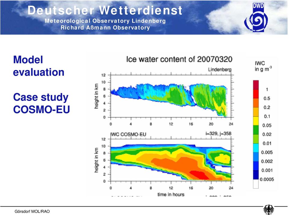
16 Model evaluation Case study COSMO-EU
17 Summary MIRA36 powerful and reliable system for measurements of cloud parameters Estimation of cloud boundaries by combination with ceilometer measurements Retrieval of microphysical cloud parameters (LWC, IWC) by CLOUDNET -Algorithm and Integrated Profiling Technique Future work: - quality assessment and control (radar calibration) - test of new spectral based data processing techniques
 - test of new spectral based data processing")
18 Availability 2004: 83 % 2005: 95 % 2006: 98 % 2007: 92 %

19 Summary MIRA36 powerful and reliable system for measurements of cloud parameters Cloud base and cloud top even of optical thick and/or multilayer clouds can be derived (cloud base by combination with ceilometer measurements) Retrieval of microphysical cloud parameters (LWC, IWC) by CLOUDNET -Algorithm and Integrated Profiling Technique Future work: - quality assessment and control (radar calibration) - application and test of new spectral based data processing techniques - cloud statistics
 - application and test of new spectral based data processing techniques - cloud")
20 Thank you for your attention

21 Überprüfung der Radarkonstanten C durch Vergleich der Reflektivitäten mit denen eines Mikroregenradars Reflektivität (MIRA), dbz y=0.992x für RR >1.0 mm/h RR < 1.0 mm/h RR < 0.7 mm/h RR < 0.4 mm/h RR <0.1 mm/h Reflektivität (MRR), dbz
22 Sc
23 Ac
24
25 Mikrophysikalische Wolkenparameter Liquid water content (LWC), Ice water content (IWC) Cloudnet Radar Ceilometer Modell Regensensor Targetklassifikation IPT Radiosonde Berechnung des LWC Profils (Z LWC) Berechnung des adiabatischen LWCprofils Berechnung des IWC Profils (Z IWC) MWP Optimal Estimation MWP Skalierung mit LWP von MWP LWC LWC LWC
26 Deutscher Wetterdienst
27 Operation principle Wolke halbe Pulslänge Transmitting of em pulses ausgesandter Puls mit Hydrometeoren angefülltes Messvolumen receiving of backscattered signals in the two polarization channels simultanuous processing of both channels and calculation of Dopplerspectrum radiale Distanz rückgestreuter Anteil des ausgesandten Pulses Öffnungswinkel Radar
28
29 Adiabatic Adiabatic & scaled IPT
30
31
32
33
6.3.2. Operate three cloud remote sensing stations. Work Package 2.
 6.3.2. Operate three cloud remote sensing stations. Work Package 2. Section 1 summarises the cloud net stations, section 2 lists the instruments operating at the various stations and their performance
ABSTRACT INTRODUCTION
 Observing Fog And Low Cloud With A Combination Of 78GHz Cloud Radar And Laser Met Office: Darren Lyth 1, John Nash. Rutherford Appleton Laboratory: M.Oldfield ABSTRACT Results from two demonstration tests
Radiometer Physics GmbH Discrimination of cloud and rain liquid water path by groundbased polarized microwave radiometry
 Radiometer Physics GmbH Discrimination of cloud and rain liquid water path by groundbased polarized microwave radiometry Harald Czekala RPG Radiometer Physics GmbH AOGS Meeting, Singapore, July 6, 2004
Diurnal Cycle: Cloud Base Height clear sky
 Diurnal Cycle: Cloud Base Height clear sky Helsinki CNN I Madrid, 16 Dezember 2002 1 Cabauw Geesthacht Cabauw Geesthacht Helsinki Helsinki Petersburg Potsdam Petersburg Potsdam CNN I CNN II Madrid, 16
Combining Satellite High Frequency Microwave Radiometer & Surface Cloud Radar Data for Determination of Large Scale 3 D Cloud IWC 서은경
 11/21/2008 제9회 기상레이더 워크숍 Combining Satellite High Frequency Microwave Radiometer & Surface Cloud Radar Data for Determination of Large Scale 3 D Cloud IWC 서은경 공주대학교 지구과학교육과 Objective: To retrieve large
VALIDATION OF SAFNWC / MSG CLOUD PRODUCTS WITH ONE YEAR OF SEVIRI DATA
 VALIDATION OF SAFNWC / MSG CLOUD PRODUCTS WITH ONE YEAR OF SEVIRI DATA M.Derrien 1, H.Le Gléau 1, Jean-François Daloze 2, Martial Haeffelin 2 1 Météo-France / DP / Centre de Météorologie Spatiale. BP 50747.
Long-term Observations of the Convective Boundary Layer (CBL) and Shallow cumulus Clouds using Cloud Radar at the SGP ARM Climate Research Facility
 and Shallow cumulus Clouds using Cloud Radar at the SGP ARM Climate Research Facility") Long-term Observations of the Convective Boundary Layer (CBL) and Shallow cumulus Clouds using Cloud Radar at the SGP ARM Climate Research Facility Arunchandra S. Chandra Pavlos Kollias Department of Atmospheric
Long-term Observations of the Convective Boundary Layer (CBL) and Shallow cumulus Clouds using Cloud Radar at the SGP ARM Climate Research Facility Arunchandra S. Chandra Pavlos Kollias Department of Atmospheric
Summary Report on National and Regional Projects set-up in Russian Federation to integrate different Ground-based Observing Systems
 WORLD METEOROLOGICAL ORGANIZATION COMMISSION FOR INSTRUMENT AND METHODS OF OBSERVATION OPAG-UPPER AIR EXPERT TEAM ON REMOTE SENSING UPPER-AIR TECHNOLOGY AND TECHNIQUES First Session Geneva, Switzerland,
Passive and Active Microwave Remote Sensing of Cold-Cloud Precipitation : Wakasa Bay Field Campaign 2003
 Passive and Active Microwave Remote Sensing of Cold-Cloud Precipitation : Wakasa Bay Field Campaign 3 Benjamin T. Johnson,, Gail Skofronick-Jackson 3, Jim Wang 3, Grant Petty jbenjam@neptune.gsfc.nasa.gov
Science Goals for the ARM Recovery Act Radars
 DOE/SC-ARM-12-010 Science Goals for the ARM Recovery Act Radars JH Mather May 2012 DISCLAIMER This report was prepared as an account of work sponsored by the U.S. Government. Neither the United States
Validation of SEVIRI cloud-top height retrievals from A-Train data
 Validation of SEVIRI cloud-top height retrievals from A-Train data Chu-Yong Chung, Pete N Francis, and Roger Saunders Contents Introduction MO GeoCloud AVAC-S Long-term monitoring Comparison with OCA Summary
Remote Sensing of Clouds from Polarization
 Remote Sensing of Clouds from Polarization What polarization can tell us about clouds... and what not? J. Riedi Laboratoire d'optique Atmosphérique University of Science and Technology Lille / CNRS FRANCE
Roelof Bruintjes, Sarah Tessendorf, Jim Wilson, Rita Roberts, Courtney Weeks and Duncan Axisa WMA Annual meeting 26 April 2012
 Aerosol affects on the microphysics of precipitation development in tropical and sub-tropical convective clouds using dual-polarization radar and airborne measurements. Roelof Bruintjes, Sarah Tessendorf,
Mixed-phase layer clouds
 Mixed-phase layer clouds Chris Westbrook and Andrew Barrett Thanks to Anthony Illingworth, Robin Hogan, Andrew Heymsfield and all at the Chilbolton Observatory What is a mixed-phase cloud? Cloud below
Surface-Based Remote Sensing of the Aerosol Indirect Effect at Southern Great Plains
 Surface-Based Remote Sensing of the Aerosol Indirect Effect at Southern Great Plains G. Feingold and W. L. Eberhard National Oceanic and Atmospheric Administration Environmental Technology Laboratory Boulder,
Arctic Cloud Microphysics Retrievals from Surface-Based Remote Sensors at SHEBA
 1544 J O U R N A L O F A P P L I E D M E T E O R O L O G Y VOLUME 44 Arctic Cloud Microphysics Retrievals from Surface-Based Remote Sensors at SHEBA MATTHEW D. SHUPE Cooperative Institute for Research
Weather Radar Basics
 Weather Radar Basics RADAR: Radio Detection And Ranging Developed during World War II as a method to detect the presence of ships and aircraft (the military considered weather targets as noise) Since WW
Towards an NWP-testbed
 Towards an NWP-testbed Ewan O Connor and Robin Hogan University of Reading, UK Overview Cloud schemes in NWP models are basically the same as in climate models, but easier to evaluate using ARM because:
ADM-Aeolus pre-launch campaigns with an airborne instrument demonstrator
 ADM-Aeolus pre-launch campaigns with an airborne instrument demonstrator Oliver Reitebuch Institut für Physik der Atmosphäre Background The ADM-Aeolus instrument ALADIN uses several novel techniques, like
Sensitivity of Surface Cloud Radiative Forcing to Arctic Cloud Properties
 Sensitivity of Surface Cloud Radiative Forcing to Arctic Cloud Properties J. M. Intrieri National Oceanic and Atmospheric Administration Environmental Technology Laboratory Boulder, Colorado M. D. Shupe
Cloud Thickness Estimation from GOES-8 Satellite Data Over the ARM-SGP Site
 Cloud Thickness Estimation from GOES-8 Satellite Data Over the ARM-SGP Site V. Chakrapani, D. R. Doelling, and A. D. Rapp Analytical Services and Materials, Inc. Hampton, Virginia P. Minnis National Aeronautics
A climatology of cirrus clouds from ground-based lidar measurements over Lille
 A climatology of cirrus clouds from ground-based lidar measurements over Lille Rita Nohra, Frédéric Parol, Philippe Dubuisson Laboratoire d Optique Atmosphérique université de Lille, CNRS UMR 8518 Objectives
A glance at compensating errors between low-level cloud fraction and cloud optical properties using satellite retrievals
 A glance at compensating errors between low-level cloud fraction and cloud optical properties using satellite retrievals Christine Nam & Sandrine Bony Laboratoire de Météorologie Dynamique Structure Overview
MCMC-Based Assessment of the Error Characteristics of a Surface-Based Combined Radar - Passive Microwave Cloud Property Retrieval
 MCMC-Based Assessment of the Error Characteristics of a Surface-Based Combined Radar - Passive Microwave Cloud Property Retrieval Derek J. Posselt University of Michigan Jay G. Mace University of Utah
Evaluation of a large-eddy model simulation of a mixed-phase altocumulus cloud using microwave radiometer, lidar and Doppler radar data
 Q. J. R. Meteorol. Soc. (2006), 132, pp. 1693 1715 doi: 10.1256/qj.05.145 Evaluation of a large-eddy model simulation of a mixed-phase altocumulus cloud using microwave radiometer, lidar and Doppler radar
Feuer und Eis: von den Tücken der
 Feuer und Eis: von den Tücken der Schneefallfernerkundung What happened Prof. Susanne Crewell after Institut für Geophysik und Meteorologie CLIWA-NET 2000-2003? Prof. Susanne Crewell University of Cologne
Wintry weather: improved nowcasting through data fusion
 Wintry weather: improved nowcasting through data fusion Arnold Tafferner, Felix Keis DLR Institut für Physik der Atmosphäre (IPA) Wetter&Fliegen Final Colloquium, MAC MUC, 15 March 2012 1 Outline The problem
Wind Field Observations with a Monostatic and Bistatic C-band Doppler Radar Network
 Wind Field Observations with a Monostatic and Bistatic C-band Doppler Radar Network Martin Hagen, DLR Oberpfaffenhofen Wind field and Doppler radar Doppler radar (and lidar) can only measure one component
WSR - Weather Surveillance Radar
 1 of 7 Radar by Paul Sirvatka College of DuPage Meteorology WSR - Weather Surveillance Radar It was learned during World War II that electromagnetic radiation could be sent out, bounced off an object and
Tools for Viewing and Quality Checking ARM Data
 Tools for Viewing and Quality Checking ARM Data S. Bottone and S. Moore Mission Research Corporation Santa Barbara, California Introduction Mission Research Corporation (MRC) is developing software tools
Evaluation of the Effect of Upper-Level Cirrus Clouds on Satellite Retrievals of Low-Level Cloud Droplet Effective Radius
 Evaluation of the Effect of Upper-Level Cirrus Clouds on Satellite Retrievals of Low-Level Cloud Droplet Effective Radius F.-L. Chang and Z. Li Earth System Science Interdisciplinary Center University
Comparison of visual observations and automated ceilometer cloud reports at Blindern, Oslo. Anette Lauen Borg Remote sensing MET-Norway
 Comparison of visual observations and automated ceilometer cloud reports at Blindern, Oslo Anette Lauen Borg Remote sensing MET-Norway A test of our ceilometer data To fully exploit our new ceilometer
SAFNWC/MSG Cloud type/height. Application for fog/low cloud situations
 SAFNWC/MSG Cloud type/height. Application for fog/low cloud situations 22 September 2011 Hervé LE GLEAU, Marcel DERRIEN Centre de météorologie Spatiale. Lannion Météo-France 1 Fog or low level clouds?
Satellite Remote Sensing of Volcanic Ash
 Marco Fulle www.stromboli.net Satellite Remote Sensing of Volcanic Ash Michael Pavolonis NOAA/NESDIS/STAR SCOPE Nowcasting 1 Meeting November 19 22, 2013 1 Outline Getty Images Volcanic ash satellite remote
The study of cloud and aerosol properties during CalNex using newly developed spectral methods
 The study of cloud and aerosol properties during CalNex using newly developed spectral methods Patrick J. McBride, Samuel LeBlanc, K. Sebastian Schmidt, Peter Pilewskie University of Colorado, ATOC/LASP
G. Karasinski, T. Stacewicz, S.Chudzynski, W. Skubiszak, S. Malinowski 1, A. Jagodnicka Institute of Experimental Physics, Warsaw University, Poland
 P1.7 INVESTIGATION OF ATMOSPHERIC AEROSOL WITH MULTIWAVELENGTH LIDAR G. Karasinski, T. Stacewicz, S.Chudzynski, W. Skubiszak, S. Malinowski 1, A. Jagodnicka Institute of Experimental Physics, Warsaw University,
Using lidar and radar to evaluate cloud forecasts in operational models.
 Using lidar and radar to evaluate cloud forecasts in operational models. Anthony Illingworth, + Robin Hogan, Ewan O Connor, U of Reading, UK and many others at the U of Reading and in the CloudNET team
THE MORPHOLOGY AND PROCESSES OF A DEEP, MULTI-LAYERED ARCTIC CLOUD SYSTEM
 THE MORPHOLOGY AND PROCESSES OF A DEEP, MULTI-LAYERED ARCTIC CLOUD SYSTEM M. Rambukkange 1, J. Verlinde 1, P. Kollias 2,and E. Luke 3 1 Penn State University, University Park, PA 2 McGill University, Montreal,
The ARM-GCSS Intercomparison Study of Single-Column Models and Cloud System Models
 The ARM-GCSS Intercomparison Study of Single-Column Models and Cloud System Models R. T. Cederwall and D. J. Rodriguez Atmospheric Science Division Lawrence Livermore National Laboratory Livermore, California
REMOTE SENSING OF CLOUD-AEROSOL RADIATIVE EFFECTS FROM SATELLITE DATA: A CASE STUDY OVER THE SOUTH OF PORTUGAL
 REMOTE SENSING OF CLOUD-AEROSOL RADIATIVE EFFECTS FROM SATELLITE DATA: A CASE STUDY OVER THE SOUTH OF PORTUGAL D. Santos (1), M. J. Costa (1,2), D. Bortoli (1,3) and A. M. Silva (1,2) (1) Évora Geophysics
How To Find Out How Much Cloud Fraction Is Underestimated
 Parameterizing the difference in cloud fraction defined by area and by volume as observed with radar and lidar MALCOLM E. BROOKS 1 2, ROBIN J. HOGAN, AND ANTHONY J. ILLINGWORTH Department of Meteorology,
GOES-R AWG Cloud Team: ABI Cloud Height
 GOES-R AWG Cloud Team: ABI Cloud Height June 8, 2010 Presented By: Andrew Heidinger 1 1 NOAA/NESDIS/STAR 1 Outline Executive Summary Algorithm Description ADEB and IV&V Response Summary Requirements Specification
Cloud Type and Macrophysical Property Retrieval Using Multiple Remote Sensors
 VOLUME 4 JOURNAL OF APPLIED METEOROLOGY OCTOBER 2 Cloud Type and Macrophysical Property Retrieval Using Multiple Remote Sensors ZHIEN WANG AND KENNETH SASSEN Department of Meteorology, University of Utah,
How To Use A Karlsruhe Doppler Lidar
 Andreas Wieser Institut für Meteorologie und Klimaforschung Forschungsbereich Troposphäre (IMK-TRO) First measurements with the new Karlsruhe Doppler Lidar June 03, 2004 Forschungszentrum Karlsruhe we
High-Resolution Doppler-Polarimetric FMCW Radar with Dual-Orthogonal Signals
 High-Resolution Doppler-Polarimetric FMCW Radar with Dual-Orthogonal Signals Oleg Krasnov, Leo Ligthart, Zhijian Li, Galina Babur, Zongbo Wang, Fred van der Zwan International Research Centre for Telecommunications
Cloud verification: a review of methodologies and recent developments
 Cloud verification: a review of methodologies and recent developments Anna Ghelli ECMWF Slide 1 Thanks to: Maike Ahlgrimm Martin Kohler, Richard Forbes Slide 1 Outline Cloud properties Data availability
A SURVEY OF CLOUD COVER OVER MĂGURELE, ROMANIA, USING CEILOMETER AND SATELLITE DATA
 Romanian Reports in Physics, Vol. 66, No. 3, P. 812 822, 2014 ATMOSPHERE PHYSICS A SURVEY OF CLOUD COVER OVER MĂGURELE, ROMANIA, USING CEILOMETER AND SATELLITE DATA S. STEFAN, I. UNGUREANU, C. GRIGORAS
RPG MWR PRO TN03 2012 09 Page 1 / 12 www.radiometer physics.de Radiometer Physics GmbH +49 2225 99981 0
 Applications Tropospheric profiling of temperature, humidity and liquid water High resolution boundary layer temperature profiles, better resolution than balloons Input for weather and climate models (data
A model to observation approach to evaluating cloud microphysical parameterisations using polarimetric radar
 A model to observation approach to evaluating cloud microphysical parameterisations using polarimetric radar Monika Pfeifer G. Craig, M. Hagen, C. Keil Polarisation Doppler Radar POLDIRAD Rain Graupel
On the Relationship between Thermodynamic Structure and Cloud Top, and Its Climate Significance in the Arctic
 2374 J O U R N A L O F C L I M A T E VOLUME 25 On the Relationship between Thermodynamic Structure and Cloud Top, and Its Climate Significance in the Arctic JOSEPH SEDLAR Remote Sensing Division, Research
Fog and low cloud ceilings in the northeastern US: climatology and dedicated field study
 Fog and low cloud ceilings in the northeastern US: climatology and dedicated field study Robert Tardif National Center for Atmospheric Research Research Applications Laboratory 1 Overview of project Objectives:
How To Understand And Understand The Physics Of Clouds And Precipitation
 Deutscher Wetterdienst Research and Development Physical Parameterizations: Cloud Microphysics and Subgrid-Scale Cloudiness Axel Seifert Deutscher Wetterdienst, Offenbach Deutscher Wetterdienst Research
Profiles of Low-Level Stratus Cloud Microphysics Deduced from Ground-Based Measurements
 42 JOURNAL OF ATMOSPHERIC AND OCEANIC TECHNOLOGY VOLUME 20 Profiles of Low-Level Stratus Cloud Microphysics Deduced from Ground-Based Measurements XIQUAN DONG* AND GERALD G. MACE Meteorology Department,
UNIVERSITY OF READING
 UNIVERSITY OF READING Department of Meteorology Evaluating Numerical Model Cloud Parameterizations using Radar and Lidar Simulation Jonathan Mark Wilkinson A thesis submitted for the degree of Doctor of
Radar Interferometric and Polarimetric Possibilities for Determining Sea Ice Thickness
 Radar Interferometric and Polarimetric Possibilities for Determining Sea Ice Thickness by Scott Hensley, Ben Holt, Sermsak Jaruwatanadilok, Jeff Steward, Shadi Oveisgharan Delwyn Moller, Jim Reis, Andy
Iden%fying CESM cloud and surface biases at Summit, Greenland
 Iden%fying CESM cloud and surface biases at Summit, Greenland Nathaniel Miller (CU- ATOC, CIRES) MaEhew Shupe, Andrew GeEleman, Jennifer Kay, Line Bourdages CESM Ice Sheet Surface Biases Cross Working
PARSAX: Polarimetric Agile Radar in S- and X-band new generation of polarimetric radar
 PARSAX: Polarimetric Agile Radar in S- and X-band new generation of polarimetric radar PARSAX Project team: Oleg Krasnov, Leo Ligthart, Zhijian Li, Galina Babur, Fred van der Zwan, Zongbo Wang, Piet van
GCMs with Implicit and Explicit cloudrain processes for simulation of extreme precipitation frequency
 GCMs with Implicit and Explicit cloudrain processes for simulation of extreme precipitation frequency In Sik Kang Seoul National University Young Min Yang (UH) and Wei Kuo Tao (GSFC) Content 1. Conventional
Developing Continuous SCM/CRM Forcing Using NWP Products Constrained by ARM Observations
 Developing Continuous SCM/CRM Forcing Using NWP Products Constrained by ARM Observations S. C. Xie, R. T. Cederwall, and J. J. Yio Lawrence Livermore National Laboratory Livermore, California M. H. Zhang
Outline. Case Study over Vale do Paraiba 11 February 2012. Comparison of different rain rate retrievals for heavy. Future Work
 Outline Short description of the algorithms for rain rate retrievals from passive microwave radiometers on board low-orbiting satellites (i.e., SSMI/S) Case Study over Vale do Paraiba 11 February 2012
Radar Systems Engineering Lecture 6 Detection of Signals in Noise
 Radar Systems Engineering Lecture 6 Detection of Signals in Noise Dr. Robert M. O Donnell Guest Lecturer Radar Systems Course 1 Detection 1/1/010 Block Diagram of Radar System Target Radar Cross Section
Multiangle cloud remote sensing from
 Multiangle cloud remote sensing from POLDER3/PARASOL Cloud phase, optical thickness and albedo F. Parol, J. Riedi, S. Zeng, C. Vanbauce, N. Ferlay, F. Thieuleux, L.C. Labonnote and C. Cornet Laboratoire
Email: tjohn@mail.nplindia.ernet.in
 USE OF VIRTUAL INSTRUMENTS IN RADIO AND ATMOSPHERIC EXPERIMENTS P.N. VIJAYAKUMAR, THOMAS JOHN AND S.C. GARG RADIO AND ATMOSPHERIC SCIENCE DIVISION, NATIONAL PHYSICAL LABORATORY, NEW DELHI 110012, INDIA
How To Monitor Sea Level With Satellite Radar
 Satellite Altimetry Wolfgang Bosch Deutsches Geodätisches Forschungsinstitut (DGFI), München email: bosch@dgfi.badw.de Objectives You shall recognize satellite altimetry as an operational remote sensing
1. Specific Differential Phase (KDP)
") 1. Specific Differential Phase (KDP) Instructor Notes: Welcome to the dual polarization radar course. I am Clark Payne with the Warning Decision Training Branch. This lesson is part of the dual-pol products
1. Specific Differential Phase (KDP) Instructor Notes: Welcome to the dual polarization radar course. I am Clark Payne with the Warning Decision Training Branch. This lesson is part of the dual-pol products
Accuracy of cloud liquid water path from ground-based microwave radiometry 1. Dependency on cloud model statistics
 RADIO SCIENCE, VOL. 38, NO. 3, 8041, doi:10.1029/2002rs002654, 2003 Accuracy of cloud liquid water path from ground-based microwave radiometry 1. Dependency on cloud model statistics Ulrich Löhnert and
Passive Remote Sensing of Clouds from Airborne Platforms
 Passive Remote Sensing of Clouds from Airborne Platforms Why airborne measurements? My instrument: the Solar Spectral Flux Radiometer (SSFR) Some spectrometry/radiometry basics How can we infer cloud properties
Heikki Turtiainen *, Pauli Nylander and Pekka Puura Vaisala Oyj, Helsinki, Finland. Risto Hölttä Vaisala Inc, Boulder, Colorado
 4.1 A NEW HIGH ACCURACY, LOW MAINTENANCE ALL WEATHER PRECIPITATION GAUGE FOR METEOROLOGICAL, HYDROLOGICAL AND CLIMATOLOGICAL APPLICATIONS Heikki Turtiainen *, Pauli Nylander and Pekka Puura Vaisala Oyj,
Cloud/Hydrometeor Initialization in the 20-km RUC Using GOES Data
 WORLD METEOROLOGICAL ORGANIZATION COMMISSION FOR BASIC SYSTEMS OPEN PROGRAMMME AREA GROUP ON INTEGRATED OBSERVING SYSTEMS EXPERT TEAM ON OBSERVATIONAL DATA REQUIREMENTS AND REDESIGN OF THE GLOBAL OBSERVING
Cirrus Microphysical Properties and Air Motion Statistics Using Cloud Radar Doppler Moments. Part I: Algorithm Description
 1690 J O U R N A L O F A P P L I E D M E T E O R O L O G Y A N D C L I M A T O L O G Y VOLUME 45 Cirrus Microphysical Properties and Air Motion Statistics Using Cloud Radar Doppler Moments. Part I: Algorithm
VAMP Vertical Aeolus Measurement Positioning
 VAMP Vertical Aeolus Measurement Positioning Ad.Stoffelen@knmi.nl Gert-Jan Marseille, Karim Houchi, Jos de Kloe (KNMI) Heiner Körnich (MISU), Harald Schyberg (MetNo) Space Shuttle, 84, 3 pm LT Vertical
2. THE TEORRETICAL OF GROUND PENETRATING RADAR:
 Sixteenth International Water Technology Conference, IWTC 16 2012, Istanbul, Turkey 1 THE USE OF GROUND PENETRATING RADAR WITH A FREQUENCY 1GHZ TO DETECT WATER LEAKS FROM PIPELINES Alaa Ezzat Hasan Ministry
Climatology of aerosol and cloud properties at the ARM sites:
 Climatology of aerosol and cloud properties at the ARM sites: MFRSR combined with other measurements Qilong Min ASRC, SUNY at Albany MFRSR: Spectral irradiances at 6 six wavelength passbands: 415, 500,
ERAD 2002. Proceedings of ERAD (2002): 173 178 c Copernicus GmbH 2002
: 173 178 c Copernicus GmbH 2002") Proceedings of ERAD (22): 173 178 c Copernicus GmbH 22 ERAD 22 An enhanced algorithm for the retrieval of liquid water cloud properties from simultaneous radar and lidar measurements. Part I: The basic
Proceedings of ERAD (22): 173 178 c Copernicus GmbH 22 ERAD 22 An enhanced algorithm for the retrieval of liquid water cloud properties from simultaneous radar and lidar measurements. Part I: The basic
Radar Measurement of Rain Storage in a Deciduous Tree
 39 Chapter 3 Radar Measurement of Rain Storage in a Deciduous Tree Joost de Jong, Henk de Groot, Wim Klaassen, and Piet Kuiper Abstract. The potential of radar to estimate the amount of rain, stored in
Module 13 : Measurements on Fiber Optic Systems
 Module 13 : Measurements on Fiber Optic Systems Lecture : Measurements on Fiber Optic Systems Objectives In this lecture you will learn the following Measurements on Fiber Optic Systems Attenuation (Loss)
Monitoring of Arctic Conditions from a Virtual Constellation of Synthetic Aperture Radar Satellites
 DISTRIBUTION STATEMENT A. Approved for public release; distribution is unlimited. Monitoring of Arctic Conditions from a Virtual Constellation of Synthetic Aperture Radar Satellites Hans C. Graber RSMAS
The impact of window size on AMV
 The impact of window size on AMV E. H. Sohn 1 and R. Borde 2 KMA 1 and EUMETSAT 2 Abstract Target size determination is subjective not only for tracking the vector but also AMV results. Smaller target
EVALUATION OF OPERATIONAL MODEL CLOUD REPRESENTATION USING ROUTINE RADAR/LIDAR MEASUREMENTS
 6A.3 EVALUATION OF OPERATIONAL MODEL CLOUD REPRESENTATION USING ROUTINE RADAR/LIDAR MEASUREMENTS Dominique Bouniol GAME/CNRM, CNRS/Météo-France, Toulouse, France Alain Protat CETP, CNRS, Vélizy, Paris
Solar Irradiance Forecasting Using Multi-layer Cloud Tracking and Numerical Weather Prediction
 Solar Irradiance Forecasting Using Multi-layer Cloud Tracking and Numerical Weather Prediction Jin Xu, Shinjae Yoo, Dantong Yu, Dong Huang, John Heiser, Paul Kalb Solar Energy Abundant, clean, and secure
Monitoring a Changing Environment with Synthetic Aperture Radar. Alaska Satellite Facility National Park Service Don Atwood
 Monitoring a Changing Environment with Synthetic Aperture Radar Don Atwood Alaska Satellite Facility 1 Entering the SAR Age 2 SAR Satellites RADARSAT-1 Launched 1995 by CSA 5.6 cm (C-Band) HH Polarization
Calibration of the MASS time constant by simulation
 Calibration of the MASS time constant by simulation A. Tokovinin Version 1.1. July 29, 2009 file: prj/atm/mass/theory/doc/timeconstnew.tex 1 Introduction The adaptive optics atmospheric time constant τ
The Influence of the Climatic Peculiarities on the Electromagnetic Waves Attenuation in the Baltic Sea Region
 PIERS ONLINE, VOL. 4, NO. 3, 2008 321 The Influence of the Climatic Peculiarities on the Electromagnetic Waves Attenuation in the Baltic Sea Region M. Zilinskas 1,2, M. Tamosiunaite 2,3, S. Tamosiunas
Implementation of a Gabor Transform Data Quality-Control Algorithm for UHF Wind Profiling Radars
 VOLUME 30 J O U R N A L O F A T M O S P H E R I C A N D O C E A N I C T E C H N O L O G Y DECEMBER 2013 Implementation of a Gabor Transform Data Quality-Control Algorithm for UHF Wind Profiling Radars
Cloud Remote Sensing. retrieval-breakdown to better understand cloud/aerosol/precip. cloud/aerosol/precipbehavior. characteristic/opportunityfor
 Cloud Remote Sensing -integral -integraltotovocals VOCALSobjectives objectives -we -wewant wanttotodo dothe thebest bestwe wecan: can: * *marine marinestratus stratusover overocean oceanisisthe theidealization
Geography 403 Lecture 7 Scanners, Thermal, and Microwave
 Geography 403 Lecture 7 Scanners, Thermal, and Microwave Needs: Lect_403_7.ppt A. Basics of Passive Electric Sensors 1. Sensors absorb EMR and produce some sort of response, such as voltages differences
SURFACE SOURCE OF ICE PARTICLES IN MOUNTAIN CLOUDS
 SURFACE SOURCE OF ICE PARTICLES IN MOUNTAIN CLOUDS Gabor Vali, Bart Geerts, David Leon and Jefferson R. Snider. Department of Atmospheric Science, University of Wyoming Laramie, WY USA.
Group Session 1-3 Rain and Cloud Observations
 Group Session 1-3 Rain and Cloud Observations Targets in Science Plans CINDY Science Plan (Apr. 2009) DYNAMO SPO (Jul. 2009) Atmospheric Research a. Preconditioning processes b. Rossby wave c. Diabatic
Cloud Radiative Forcing of the Arctic Surface: The Influence of Cloud Properties, Surface Albedo, and Solar Zenith Angle
 616 JOURNAL OF CLIMATE Cloud Radiative Forcing of the Arctic Surface: The Influence of Cloud Properties, Surface Albedo, and Solar Zenith Angle MATTHEW D. SHUPE Science and Technology Corporation, NOAA/Environmental
How To Find Out How Much Cloud Fraction Is Underestimated
 2248 J O U R N A L O F T H E A T M O S P H E R I C S C I E N C E S VOLUME 62 Parameterizing the Difference in Cloud Fraction Defined by Area and by Volume as Observed with Radar and Lidar MALCOLM E. BROOKS,*
Observations of a glaciating hole-punch cloud Chris Westbrook Owain Davies What are they? Observations
 Observations of a glaciating hole-punch cloud Chris Westbrook Department of Meteorology, University of Reading Owain Davies STFC Chilbolton Facility for Atmospheric and Radio Research In his fascinating
Cloud Remote Sensing during VOCALS- REx: Selected U.S. Efforts
 Cloud Remote Sensing during VOCALS- REx: Selected U.S. Efforts Paquita Zuidema, U of Miami Qabs ~ 4xI{(m 2-1)/(m 2 +2)} Qscat ~ 8/3 x 4 (m 2-1)/(m 2 +2) 2 x=2 r/ VOCALS Educational Talk 10/31/08 1. Satellite
SARAL ACCESS TO OFF-LINE DATA
 SARAL AltiKa introduction Plot of the SARAL/AltiKa ground track over Africa (Credits: Google). S ARAL/AltiKa is a new mission in cooperation between CNES and ISRO (Indian Space Research Organization),
Monitoring of water level, waves and ice with radar gauges
 Ulrich Barjenbruch 1 Stephan Mai 2 Dr. rer. nat. habil. Dipl.-Phys. Dipl.-Ing. barjenbruch@bafg.de Stephan.Mai@mbox.fi.uni-hannover.de Nino Ohle 2 Peter Mertinatis 1 Kai Irschik 2 Dipl.-Ing. Dipl.-Ing.
Guy Carpenter Asia-Pacific Climate Impact Centre, School of energy and Environment, City University of Hong Kong
 Diurnal and Semi-diurnal Variations of Rainfall in Southeast China Judy Huang and Johnny Chan Guy Carpenter Asia-Pacific Climate Impact Centre School of Energy and Environment City University of Hong Kong
RPG Radiometer Deployment Experience
 Radiometer Physics GmbH RPG Radiometer Physics GmbH - Birkenmaarstraße 10-53340 Meckenheim/Germany Tel.: +49-(0)2225/999810 Fax: +49-(0)2225/9998199 E-Mail: Dr. Thomas Rose rose@radiometer-physics.de Achim
COMPARISON OF EISCAT RADAR DATA ON SPACE DEBRIS WITH MODEL PREDICTIONS BY THE MASTER MODEL OF ESA
 PEDAS1-B1.4-0003-02 COMPARISON OF EISCAT RADAR DATA ON SPACE DEBRIS WITH MODEL PREDICTIONS BY THE MASTER MODEL OF ESA M. Landgraf 1, R. Jehn 1, and W. Flury 1 1 ESA/ESOC, Robert-Bosch-Str. 5, 64293 Darmstadt,
IMPACT OF DRIZZLE AND 3D CLOUD STRUCTURE ON REMOTE SENSING OF CLOUD EFFECTIVE RADIUS
 IMPACT OF DRIZZLE AND 3D CLOUD STRUCTURE ON REMOTE SENSING OF CLOUD EFFECTIVE RADIUS Tobias Zinner 1, Gala Wind 2, Steven Platnick 2, Andy Ackerman 3 1 Deutsches Zentrum für Luft- und Raumfahrt (DLR) Oberpfaffenhofen,
MSG-SEVIRI cloud physical properties for model evaluations
 Rob Roebeling Weather Research Thanks to: Hartwig Deneke, Bastiaan Jonkheid, Wouter Greuell, Jan Fokke Meirink and Erwin Wolters (KNMI) MSG-SEVIRI cloud physical properties for model evaluations Cloud