25 Years of Indian Remote Sensing Satellite (IRS) Series
|
|
|
- Barnaby Horton
- 9 years ago
- Views:
Transcription
1 25 Years of Indian Remote Sensing Satellite (IRS) Series Vinay K Dadhwal Director National Remote Sensing Centre (NRSC), ISRO Hyderabad, INDIA 50 th Session of Scientific & Technical Subcommittee of COPUOS, Feb., 2013, Vienna

2 The Beginning 1962 : Indian National Committee on Space Research (INCOSPAR), at PRL, Ahmedabad 1963 : First Sounding Rocket launch from Thumba (Nov 21, 1963) 1967 : Experimental Satellite Communication Earth Station (ESCES) established at Ahmedabad 1969 : Indian Space Research Organisation (ISRO) established (15 August)
 established (15")
3 Pre IRS-1A Satellites ARYABHATTA, first Indian satellite launched in April 1975 Ten satellites before IRS-1A (7 for EO; 2 Met) 5 Procured & 5 SLV / ASLV launch SAMIR : 3 band MW Radiometer SROSS : Stretched Rohini Series Satellite

4 Indian Remote Sensing Satellite (IRS) 1A First Operational EO Application satellite, built in India, launch USSR Carried 4-band multispectral camera (3 nos), 72m & 36m resolution Satellite Launch: March 17, 1988 Baikanur Cosmodrome Kazakhstan

5 Since IRS-1A Established of operational EO activities for EO data acquisition, processing & archival Applications & institutionalization Public services in resource & disaster management PSLV Launch Program to support EO missions International partnership, cooperation & global data sets

6 Early IRS Multispectral Sensors 1 st Generation : IRS-1A, IRS-1B 2 nd Generation : 3 tier image (WiFS/AWiFS), SWIR band ; IRS-1C/1D, Resourcesat-1/2 Mission IRS-1A IRS-1B IRS-1C IRS-1D Weight (kg) 975 kg 975 kg 1250 kg 1250 kg Onboard power@ 600 Watts 809 Watts/(9.6 sqm ) Payloads, (Solid State Push Broom Camera) LISS-1 (72.5 m) LISS-2A, 2B (36.25 m) WiFS (189 m) LISS-3 (23.6m) & PAN (<6m) Onboard TapeRecorder Gb 62 Gb Launch / Mission Completion Launch Vehicle/ Site Mar 17,1988/ Jul 1996 Aug29,1991/ Dec20,2003 Vostok,Baikanur, Kazakhstan Dec 28, 1995/ Sep 21, 2007 Molniya,Baikanur, Kazakhstan 27 Sep 1997/ Jan 2010 PSLV C1, SHAR India Orbit # (ht km) 904 km 904 km 817 km 740 x 817 km Inclination o o o Repetivity/ (Orbits) 22 days / (307 orbits) 24 days # Orbit : Polar Sun Synchronous ; & Local Time : Descending Node
 904 km 904 km 817 km 740 x 817 km Inclination 99.08 o 99.08 o 98.69 o 98.")
7 ISRO EO SATELLITES GEO / MET ISRO: Missions (68 Sat/ 33 Launch) METEOROLOGICAL SATELLITES : OCEANOGRAPHIC APPLICATION SATELLITES : CARTOGRAPHIC SATELLITES :

8 Cartographic Application Satellites PAN Camera (5.8m) onboard IRS-1C/1D (1995/ 1997) was forerunner to Cartographic series TES (2001) experimental satellites for HR images Step & stare imaging IRS-P5/Cartosat-1 (2005) in-track stereo imaging Spatial Res 2.5m, Fore & Aft cameras Global Acquisition, Indian CARTODEM, many IGS Input to creation of Orthoimages for 1:10,000 thematic mapping Step and Stare imaging Cartosat 2 (2007), 2A (2008), 2B (2010) continue panchromatic HR imaging ( < 1m resolution)

9 Ocean Satellites & Sensors IRS-P3 (Mar 21, 1996) Experimental, MOS (DLR), WiFS IRS-P4/Oceansat-1 (May 26, 1999) Ocean Color Monitor (8#, 360m) MSMR Microwave Radiometer Oceansat-2 (Sep 23, 2009) OCM, Scatterometer ROSA FUTURE & PLANS SARAL : Altimeter (Feb 2013 Launch) Oceansat-3 : Improved OCM (with TIR), Scatterometer OCM data -GAC
 Oceansat-3 : Improved OCM (with TIR), Scatterometer OCM")
10 Atmospheric & Meteorological Sensors Experimental Sensors MICROWAVE RADIOMETER : SAMIR [BHASKAR 1, 1979; BHASKAR 2, 1981], MSMR (Oceansat-1, 1999) SCATTEROMETER : OSCAT (Oceansat 2, 1999) RADIO OCCULTATION : ROSA (Oceansat 2, 1999) Operational Meteorology Sensors Geostationary (Since 1981) VHRR (2.75/11km VIS/TIR) : INSAT 1A/1B/1C/1D; INSAT 2A/2B/2C VHRR (2/8/8km VIS/WV/TIR) : INSAT 3A, KALPANA CCD (1km ) : INSAT 2E/3A Scientific Missions ISRO-CNES : Megha-tropiques (2011) MADRAS, SAPHIR, SCARAB FUTURE INSAT 3D : 6 Channel Imager & 19 Channel Sounder (Launch Mid 2013) KALPANA
 : INSAT 1A/1B/1C/1D; INSAT 2A/2B/2C VHRR (2/8/8km VIS/WV/TIR) : INSAT 3A, KALPANA CCD (1km ) : INSAT 2E/3A Scientific Missions")
11 BayNeworks t B ay Ne work s Data Acquisition, Processing & Archive Integrated Multi-mission Ground Segment for EO Satellites (IMGEOS) established at Shadnagar (NRSC) in 2011 Antartica Ground Station for EO Satellites (AGEOS) at Larsemann Hills, 2013 Many IGS has acquired IRS Data Skylink Tracking Control Pass Schedules From ISTRAC Data Acquisition Direct Ingest SAN Station Control Computer WFM NDC / UOPS Data Processing DP Systems DPS VADS DQE PQC Data Archives SAN Networks User Cartosat-1 Data Archive Indian data archive now exceeds 1000 TB

12 International Partnerships & Cooperation Data exchange & support for disaster management Indian EO satellite data reception at International Ground Stations (IGS) International sensors on Indian EO satellites MOS (Germany), ROSA (Italy), AIS (Canada) Piggy-back launch on PSLV On 11 PSLV missions, 29 foreign satellites from 18 countries Joint Missions ISRO CNES : Megha-tropiques, SARAL Global Data Sets Contribute to CEOS Global Virtual Constellation

13 Ocean Color Monitor (GAC) : Ocean & Land
 :")
14 Global Products Global data from OSCAT onboard Oceansat-2 disseminated in near real time Data acquisition at SVALBARD, NRT processing at Shadnagar (India) OCM Global Area Coverage (GAC) for ocean (8-day) and land (monthly) (W/m 2 ) Meghatropiques SCARAB SARAL data would be available from ISRO & CNES
 (W/m 2 ) Meghatropiques SCARAB SARAL data would be available")
15 Global Products -OSCAT SANDY -29 October 2012 Global data from OSCAT onboard Oceansat-2 disseminated in near real time

16
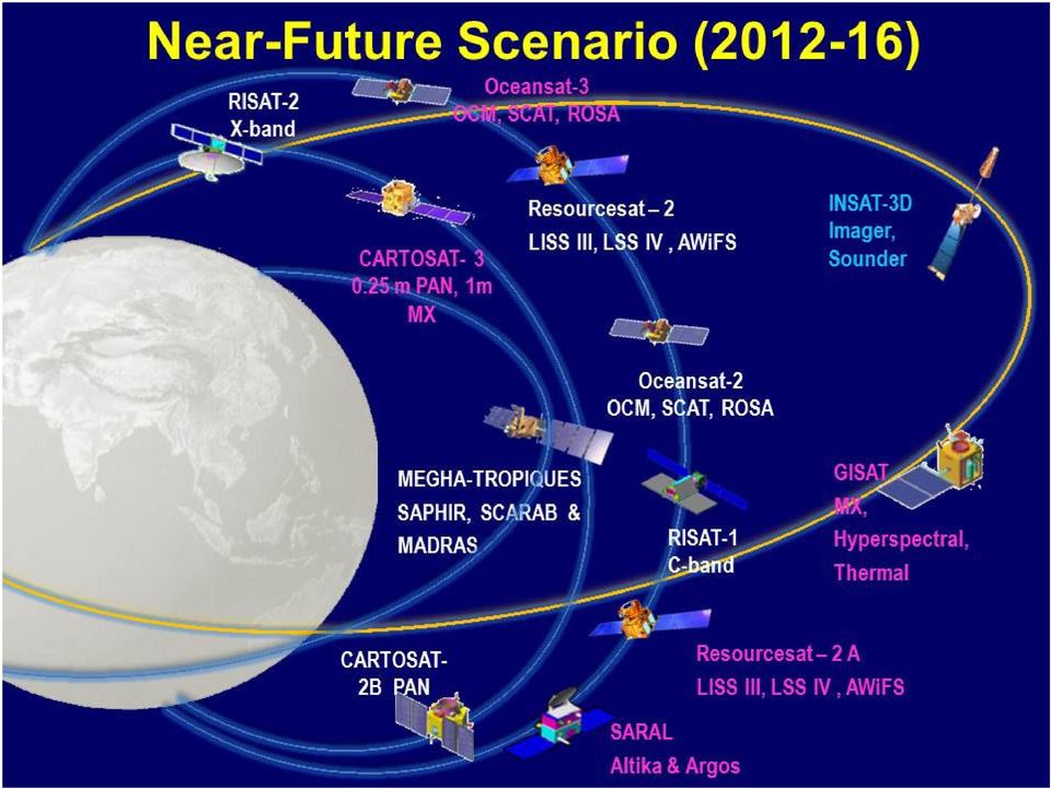
17 SARAL INSAT - 3D EO Near Future Satellites Satellite with ARgos & ALtika - Joint ISRO-CNES Mission Payloads Ka-band Altimeter (~35.5GHz) Dual freq Radiometer Status (23.8/36.8 GHz PSLV Launch : 25 Feb 2013 For improved understanding of weather systems Payloads 19 channel Sounder 6 Channel Imager GISAT Multiple acquisition from Geosynchronous Orbit Payloads High resolution MX (50 m) - VNIR (HRMX-VNIR): Hyper spectral VNIR & SWIR: 320m and 192m Res. TIR 1.5km (HRMX-TIR) Status PSLV Launch 2016/17 Resourcesat-2A Land and Water Resources Applications Continuity Mission Payloads LISS IV Mx, LISS III & AWiFS Status Launch by 2013 Status PSLV Launch : 2015/16 Followed by Oceansat-3 & Hyperspectral, Very High Resolution imaging sensors
 Status PSLV Launch 2016/17 Resourcesat-2A Land and Water Resources Applications Continuity Mission Payloads LISS IV Mx, LISS III & AWiFS Status Launch by 2013 Status")
18 UNO, Vieana Cartosat 2-A PAN & P6 LISS-IV Thank you

Indian Space Programme -Update on activities (Feb 2015)
") Indian Space Programme -Update on activities (Feb 2015) Vinay K Dadhwal India Director, National Remote Sensing Centre (NRSC), INDIAN SPACE RESEARCH ORGANISATION 52 nd Science & Technology Sub-Committee,
Indian Space Programme -Update on activities (Feb 2015) Vinay K Dadhwal India Director, National Remote Sensing Centre (NRSC), INDIAN SPACE RESEARCH ORGANISATION 52 nd Science & Technology Sub-Committee,
Vinay K Dadhwal Director. 50 th Session of Scientific & Technical Subcommittee of COPUOS, 11-22 Feb., 2013, Vienna
 Vinay K Dadhwal Director 50 th Session of Scientific & Technical Subcommittee of COPUOS, 11-22 Feb., 2013, Vienna Demonstrated applications of EO for natural resources, infrastructure, planning & disaster
Current status and Future Prospects of Indian Satellite
 Current status and Future Prospects of Indian Satellite Devendra singh and Sanjiv Nair Ministry of science and Technology Department of Science and technology Technology Bhawan,New Mehrauli Road, New Delhi-110016
Indian Diplomacy At Work
 Indian Diplomacy At Work 50 YEARS OF INDO-FRENCH SPACE CO-OPERATION BRINGING BENEFITS TO MANKIND 50 YEARS OF INDO-FRENCH SPACE CO-OPERATION Bringing Benefits to Mankind A time-tested partnership India
Archiving and Managing Remote Sensing Data Using State of the Art Storage Technologies
 Archiving and Managing Remote Sensing Data Using State of the Art Storage Technologies Ms B Lakshmi C Chandrasekhar Reddy SVSRK Kishore SDAPSA, NRSC, Hyderabad NRSC Functions Remote Sensing Data Acquisition
The National Strategy, Current Activities for Space Technology Development and Application
 14-18 November 2011, Putrajaya, Malaysia The National Strategy, Current Activities for Space Technology Development and Application Lai Anh Khoi Space Technology Institute, VAST, Vietnam Bief History Space
SARAL Project Overview ----------- CNES Activities Progress Status
 SARAL Project Overview ----------- CNES Activities Progress Status Dr. J. Noubel, P. Sengenes 2nd SARAL-AltiKa Science Workshop Ahmedabad 15-17, March, 2011 ISRO/SAC Ahmedabad - India SARAL Program SARAL
Cartosat-1 10 years and beyond
 nrsc Cartosat-1 10 years and beyond Cartosat-1 : 10 years completion in Orbit (2005-2015) 5th May 2015 National Remote Sensing Centre Indian Space Research Organisation Dept. of Space, Govt. of India Balanagar,
Remote Sensing Satellite Information Sheets Geophysical Institute University of Alaska Fairbanks
 Remote Sensing Satellite Information Sheets Geophysical Institute University of Alaska Fairbanks ASTER Advanced Spaceborne Thermal Emission and Reflection Radiometer AVHRR Advanced Very High Resolution
Disaster Management Support - Experience of ISRO
 The Role of Communication & Meteorological Satellites in Disaster Management Support - Experience of ISRO Presentation By Indian Delegation 43 rd Session of S&T Session of UN COPUOS 23 rd Feb. 2006, Vienna
Bhuvan. Indian Earth Observation Visualization. Indian Space Research Organisation. http://bhuvan.nrsc.gov.in. Multi Resolution. Societal Applications
 Multi Resolution Bhuvan Societal Applications Indian Earth Observation Visualization http://bhuvan.nrsc.gov.in 3D Geographic Models Seamless Fly Through Indian Space Research Organisation Thematic Vectors
The DLR Multi Mission EO Ground Segment
 The DLR Multi Mission EO Ground Segment Payload Ground Segment Erhard Diedrich Remote Sensing Workshop Mexico 22-24 April 2008 DLR Ground Segment for Earth Observation: Servicing GMES, national and commercial
Indian Space Research Organisation Department of Space
 22 nd Asia Pacific Regional Space Agency Forum Plenary Session 3 rd Dec, 2015 PG Diwakar NRSC Indian Space Research Organisation Department of Space INDIAN SPACE PROGRAMME Indian Space Vision Shared, Nurtured,
The first successful satellite launch by the
 CHAPTER XXX SPACE PROGRAMME The first successful satellite launch by the Soviets in 1957 ushered in the space era. At initial stages, critical military applications, national prestige and enabling space
SARAL ACCESS TO OFF-LINE DATA
 SARAL AltiKa introduction Plot of the SARAL/AltiKa ground track over Africa (Credits: Google). S ARAL/AltiKa is a new mission in cooperation between CNES and ISRO (Indian Space Research Organization),
Remote Sensing Applications in Support of Sustainable Development and Disaster Management by DLR Current Activities
 Remote Sensing Applications in Support of Sustainable Development and Disaster Management by DLR Current Activities Dr. Günter Strunz German Aerospace Center (DLR) German Remote Sensing Data Center 43rd
High Resolution Information from Seven Years of ASTER Data
 High Resolution Information from Seven Years of ASTER Data Anna Colvin Michigan Technological University Department of Geological and Mining Engineering and Sciences Outline Part I ASTER mission Terra
SPOT Satellite Earth Observation System Presentation to the JACIE Civil Commercial Imagery Evaluation Workshop March 2007
 SPOT Satellite Earth Observation System Presentation to the JACIE Civil Commercial Imagery Evaluation Workshop March 2007 Topics Presented Quick summary of system characteristics Formosat-2 Satellite Archive
Satellite Communication Systems. mgr inż. Krzysztof Włostowski Instytut Telekomunikacji PW [email protected]
 Satellite Communication Systems mgr inż. Krzysztof Włostowski Instytut Telekomunikacji PW [email protected] Satellite Communication Satellite Communication combines the missile and microwave technologies
Real Time Services for Space Applications Holger Maass, Susanne Lehner
 Real Time Services for Space Applications Holger Maass, Susanne Lehner [email protected] German Remote Sensing Data Center ( DFD ) with 2 locations in Germany Neustrelitz in Mecklenburg-Vorpommern Oberpfaffenhofen
The RapidEye optical satellite family for high resolution imagery
 'Photogrammetric Week 01' D. Fritsch & R. Spiller, Eds. Wichmann Verlag, Heidelberg 2001. Scherer, Krischke 139 The RapidEye optical satellite family for high resolution imagery STEFAN SCHERER and MANFRED
Earth remote sensing systems of middle and low resolution
 Earth remote sensing systems of middle and low resolution Serial on-line remote sensing satellites delivering data available on the world market V.I. Gershenzon (ScanEx R&D Center) In 1980, graduated from
Studying cloud properties from space using sounder data: A preparatory study for INSAT-3D
 Studying cloud properties from space using sounder data: A preparatory study for INSAT-3D Munn V. Shukla and P. K. Thapliyal Atmospheric Sciences Division Atmospheric and Oceanic Sciences Group Space Applications
China Earth Observation
 China High-resolution Earth Observation China Earth Observation System (CHEOS) and its Lastest Development The Earth Observation System and Data Center, CNSA 2014-2 Outlines 1 Introduction 2 The composition
CBERS Program Update Jacie 2011. Frederico dos Santos Liporace AMS Kepler [email protected]
 CBERS Program Update Jacie 2011 Frederico dos Santos Liporace AMS Kepler [email protected] Overview CBERS 3 and 4 characteristics Differences from previous CBERS satellites (CBERS 1/2/2B) Geometric
Document Control Sheet
 Document Control Sheet 1. Security Classification For Official Use only 2. Distribution NRSC / ISRO, Online Distribution Through Bhuvan Portal 3. Report / Document version (a) Issue no. 01 4. Report /
How To Calculate The Global Surface Temperature
 New Products and Services in 2015 Dr. A. Senthil Kumar Group Director Geophysical & Special Products NRSC (ISRO) 1 New Products & Services in 2015 ------------- Free Downloads in NICES ------------- Land
Joint Polar Satellite System (JPSS)
") Joint Polar Satellite System (JPSS) John Furgerson, User Liaison Joint Polar Satellite System National Environmental Satellite, Data, and Information Service National Oceanic and Atmospheric Administration
Joint Polar Satellite System (JPSS) John Furgerson, User Liaison Joint Polar Satellite System National Environmental Satellite, Data, and Information Service National Oceanic and Atmospheric Administration
LANDSAT 7 - GROUND SEGMENT ACTIVITIES AT THE GERMAN REMOTE SENSING DATA CENTER. Deutsches Fernerkundungsdatenzentrum (DFD) DLR (*)
 DLR (*)") LANDSAT 7 - GROUND SEGMENT ACTIVITIES AT THE GERMAN REMOTE SENSING DATA CENTER Günter Strunz (*), Hans-Dietrich Bettac (**), Jörg Gredel (*), Klaus-Dieter Reiniger (*) & Gunter Schreier (*) Deutsches Fernerkundungsdatenzentrum
LANDSAT 7 - GROUND SEGMENT ACTIVITIES AT THE GERMAN REMOTE SENSING DATA CENTER Günter Strunz (*), Hans-Dietrich Bettac (**), Jörg Gredel (*), Klaus-Dieter Reiniger (*) & Gunter Schreier (*) Deutsches Fernerkundungsdatenzentrum
16 th IOCCG Committee annual meeting. Plymouth, UK 15 17 February 2011. mission: Present status and near future
 16 th IOCCG Committee annual meeting Plymouth, UK 15 17 February 2011 The Meteor 3M Mt satellite mission: Present status and near future plans MISSION AIMS Satellites of the series METEOR M M are purposed
TUTORIAL Extraction of Geospatial Information from High Spatial Resolution Optical Satellite Sensors
 TUTORIAL Extraction of Geospatial Information from High Spatial Resolution Optical Satellite Sensors E. Baltsavias 1,L. Zhang 2, D. Holland 3, P.K. Srivastava 4, B. Gopala Krishna 4, T.P. Srinivasan 4
Status Report on current and future Geostationary Indian Satellites
 Status Report on current and future Geostationary Indian Satellites By Dr. Devendra Singh Director Satellite Meteorology India Meteorological Department New Delhi-110003 SATELLITE METEOROLOGY DIVISION
International coordination for continuity and interoperability: a CGMS perspective
 International coordination for continuity and interoperability: a CGMS perspective Peng Zhang, CGMS WG-III Co-Chair NSMC/CMA In Cooperation with Suzanne Hilding, CGMS WG-III Co-Chair OPPA/NESDIS/NOAA 1
CONCEPTUAL DESIGN OF DATA ARCHIVE AND DISTRIBUTION SYSTEM FOR GEO-KOMPSAT-2A
 CONCEPTUAL DESIGN OF DATA ARCHIVE AND DISTRIBUTION SYSTEM FOR GEO-KOMPSAT-2A In Jun Kim, Won Chan Jung, Byoung-Sun Lee, Do-Seob Ahn, Taeyoung Kim, Jaedong Jang, Hyunjong Oh ETRI, 218 Gajeong-ro, Yuseong-gu,
European Space Agency EO Missions. Ola Gråbak ESA Earth Observation Programmes Tromsø, 17 October 2012
 European Space Agency EO Missions Ola Gråbak ESA Earth Observation Programmes Tromsø, 17 October 2012 Europe and Space, A POLICY Article 189 of the Lisbon Treaty (2009) gives the European Union an explicit
Hyperspectral Satellite Imaging Planning a Mission
 Hyperspectral Satellite Imaging Planning a Mission Victor Gardner University of Maryland 2007 AIAA Region 1 Mid-Atlantic Student Conference National Institute of Aerospace, Langley, VA Outline Objective
Proba-V: Earthwatch Mission as part of ESA s Earth Observation Programmes
 Proba-V: Earthwatch Mission as part of ESA s Earth Observation Programmes Antwerp 05.07.2013 Bianca Hoersch Proba-V Mission Manager Third Party Mission & Sentinel-2 Mission Manager Earth Observation Directorate,
ORGANISATION, FUNCTIONS AND DUTIES
 A. Organisation ORGANISATION, FUNCTIONS AND DUTIES With the setting up of Indian National Committee for Space Research (INCOSPAR) in 1962, the space activities in the country were initiated. In the same
Price List. January 1 st, 2016. 1 of 40. PRICE LIST January 1 st, 2016 SLS-COM-16-001
 Price List January 1 st, 2016 1 of 40 INDEX INDEX... 2 COSMO-SKYMED... 4 IKONOS... 10 QUICKBIRD... 10 GEOEYE-1... 10 WORLDVIEW-1/2/3... 10 RADARSAT-1... 20 RADARSAT-2... 20 ASTER... 26 IRS P6... 28 IRS
ARCHIVING AND MANAGING REMOTE SENSING DATA USING STATE OF THE ART STORAGE TECHNOLOGIES
 ARCHIVING AND MANAGING REMOTE SENSING DATA USING STATE OF THE ART STORAGE TECHNOLOGIES B Lakshmi a, C Chandrasekhara Reddy a, *, SVSRK Kishore a a NRSC, SDAPSA, Hyderabad, India (lakshmi_b,sekharareddy_cc,kishore_svsr)@nrsc.gov.in
SAMPLE MIDTERM QUESTIONS
 Geography 309 Sample MidTerm Questions Page 1 SAMPLE MIDTERM QUESTIONS Textbook Questions Chapter 1 Questions 4, 5, 6, Chapter 2 Questions 4, 7, 10 Chapter 4 Questions 8, 9 Chapter 10 Questions 1, 4, 7
AT&T Global Network Client for Windows Product Support Matrix January 29, 2015
 AT&T Global Network Client for Windows Product Support Matrix January 29, 2015 Product Support Matrix Following is the Product Support Matrix for the AT&T Global Network Client. See the AT&T Global Network
RS platforms. Fabio Dell Acqua - Gruppo di Telerilevamento
 RS platforms Platform vs. instrument Sensor Platform Instrument The remote sensor can be ideally represented as an instrument carried by a platform Platforms Remote Sensing: Ground-based air-borne space-borne
ESA Earth Observation and the need for high speed networking
 ESA Earth Observation and the need for high speed networking Pisa, 11 th May 25 11 th May 25 GARR Conference 5 1 ESA Earth Observation 11 th May 25 GARR Conference 5 2 The European Space Agency The European
Presented by Gary Davis, Director, Office of Systems Development NOAA/NESDIS/OSD. Fifty Years of Achievement
 NOAA s Environmental Satellite Program: Past, Present, and Future Presented by Gary Davis, Director, Office of Systems Development NOAA/NESDIS/OSD 1 Space-Based Remote Sensors Changed Way We See Our World
INTA AIRBORNE REMOTE SENSING FACILITY from the Hasselblad s cameras to the SensyTech-AHS sensor
 INTA AIRBORNE REMOTE SENSING FACILITY from the Hasselblad s cameras to the SensyTech-AHS sensor José-Antonio Gómez-Sánchez [email protected] Remote Sensing Laboratory INSTITUTO NACIONAL DE TÉCNICA AEROESPACIAL
Sentinel-1 Mission Overview
 Sentinel-1 Mission Overview Pierre Potin Sentinel-1 Mission Manager, ESA Advanced Course on Radar Polarimetry ESRIN, Frascati, 19 January 2011 Global Monitoring for Environment and Security GMES is established
COMPARISON OF FIXED & VARIABLE RATES (25 YEARS) CHARTERED BANK ADMINISTERED INTEREST RATES - PRIME BUSINESS*
 CHARTERED BANK ADMINISTERED INTEREST RATES - PRIME BUSINESS*") COMPARISON OF FIXED & VARIABLE RATES (25 YEARS) 2 Fixed Rates Variable Rates FIXED RATES OF THE PAST 25 YEARS AVERAGE RESIDENTIAL MORTGAGE LENDING RATE - 5 YEAR* (Per cent) Year Jan Feb Mar Apr May Jun
COMPARISON OF FIXED & VARIABLE RATES (25 YEARS) 2 Fixed Rates Variable Rates FIXED RATES OF THE PAST 25 YEARS AVERAGE RESIDENTIAL MORTGAGE LENDING RATE - 5 YEAR* (Per cent) Year Jan Feb Mar Apr May Jun
Chapter Contents Page No
 Chapter Contents Page No Preface Acknowledgement 1 Basics of Remote Sensing 1 1.1. Introduction 1 1.2. Definition of Remote Sensing 1 1.3. Principles of Remote Sensing 1 1.4. Various Stages in Remote Sensing
Nigerian Satellite Systems, and her Remote Sensing Data
 Nigerian Satellite Systems, and her Remote Sensing Data S. O. Mohammed, PhD (Director-General/Chief Executive) National Space Research & Development Agency (NASRDA) A Presentation at the 2010 International
How To Run A Space Station From A Polar Relay Station
 SSC space expertise on high latitudes FMV Sensor Symposium Stockholm, September 2014 Björn Ohlson 1 50 years in space 1961 The first sounding rocket launch from Sweden 1962 Building of Esrange starts 1966
2. Orbits. FER-Zagreb, Satellite communication systems 2011/12
 2. Orbits Topics Orbit types Kepler and Newton laws Coverage area Influence of Earth 1 Orbit types According to inclination angle Equatorial Polar Inclinational orbit According to shape Circular orbit
Contributions of the geospatial fields to monitoring sustainability of urban environments John Trinder. School of Civil and Environmental Engineering
 Contributions of the geospatial fields to monitoring sustainability of urban environments John Trinder School of Civil and Environmental Engineering 2 IMPACT OF HUMAN DEVELOPMENT Humans are modifying the
Sentinel Asia System Operation Training
 1 ~ JAXA Capacity Building Program~ Sentinel Asia System Operation Training 15-17 July 2009 Makoto Kawai Satellite Applications and Promotion Center (SAPC) Space Applications Mission Directorate 2 Objective
ONE METER AND BELOW HIGH RESOLUTION SATELLITES IN PRODUCTION
 ONE METER AND BELOW HIGH RESOLUTION SATELLITES IN PRODUCTION A. Demirel, I. Bayir Inta Space Turk (Space Imaging Eurasia), Haymana Yolu 12.Km 06830 Golbasi Ankara, TURKEY ([email protected], [email protected])
Mission Operations and Ground Segment
 ESA Earth Observation Info Days Mission Operations and Ground Segment ESA EO Ground Segment and Mission Operations department (EOP-G) May 2013 EOEP 2013 Page 1 ESA Unclassified For Official Use MISSION
ERS and ENVISAT missions status
 FRINGE 2005 Workshop ERS and ENVISAT missions status Wolfgang Lengert ERS Mission Manager ERS-2 mission 14 years of ERS-1/2 data in the archive (suitable for applications requiring long term series products)
Spanish Earth Observation Programme
 Spanish Earth Observation Mónica LópezL Head of SEOSAT / Ingenio ESA s Department - Directorate of Aerospace s CDTI Centre for the Development of Industrial Technology 1 AGENDA 1. Spanish Earth Observation
Córdoba Ground Station CONAE - Argentina
 Córdoba Ground Station CONAE - Argentina Marcelo Colazo Estación Terrena Córdoba CONAE [email protected] +54 3547 431018 http://www.conae.gov.ar CONAE Ground Station Overview of facilities and operations
How To Use Data From Copernicus And Big Data To Help The Environment
 Copernicus and Big Data: Challenges and Opportunities Alessandro Annoni European Commission Joint Research Centre www.jrc.ec.europa.eu Serving society Stimulating innovation Supporting legislation Big
Development of an Integrated Data Product for Hawaii Climate
 Development of an Integrated Data Product for Hawaii Climate Jan Hafner, Shang-Ping Xie (PI)(IPRC/SOEST U. of Hawaii) Yi-Leng Chen (Co-I) (Meteorology Dept. Univ. of Hawaii) contribution Georgette Holmes
A remote sensing instrument collects information about an object or phenomenon within the
 Satellite Remote Sensing GE 4150- Natural Hazards Some slides taken from Ann Maclean: Introduction to Digital Image Processing Remote Sensing the art, science, and technology of obtaining reliable information
Chang e-3 s Progress and Achievement 2/2014
 Chang e-3 s Progress and Achievement 2/2014 Main content 1. Chinese Lunar Exploration Program 2. Chang e-3 s Progress 3. Chang e-3 s Achievement Chinese Lunar Exploration Program Phase I Orbital missions
German Earth Observation Systems and Programs Capacities for nation building
 German Earth Observation Systems and Programs Capacities for nation building German Aerospace Center, DLR, Earth Observation Center, EOC German Remote Sensing Data Center, DFD Gunter Schreier Deputy Director
Map World Forum Hyderabad, India Introduction: High and very high resolution space images: GIS Development
 Very high resolution satellite images - competition to aerial images Dr. Karsten Jacobsen Leibniz University Hannover, Germany [email protected] Introduction: Very high resolution images taken
Satellite Communications
 Satellite Communications Department of Electrical Engineering Faculty of Engineering Chiangmai University Origin of Satellite Communications Arthur C. Clark (1945) British Science fiction writer propose
Review for Introduction to Remote Sensing: Science Concepts and Technology
 Review for Introduction to Remote Sensing: Science Concepts and Technology Ann Johnson Associate Director [email protected] Funded by National Science Foundation Advanced Technological Education program [DUE
Utilization of satellites and products at Met Office since ET-SUP7
 Utilization of satellites and products at Met Office since ET-SUP7 Simon J. Keogh WMO ET-SUP8 14-17 April 2014. Table of Contents Current data usage for NWP including new data assimilated since ET-SUP7
June VV 05. Sentinel-2A LOGOTYPE COMPLET (SYMBOLE ET TYPOGRAPHIE) 294C
 294C") LOGOTYPE TONS MONOCHROME 294C June 2015 VV 05 LOGOTYPE COMPLET (SYMBOLE ET TYPOGRAPHIE) FIFTH VEGA LAUNCH FROM THE GUIANA SPACE CENTER, AT THE SERVICE OF EUROPE'S COPERNICUS PROGRAM On the fifth Vega mission
LOGOTYPE TONS MONOCHROME 294C June 2015 VV 05 LOGOTYPE COMPLET (SYMBOLE ET TYPOGRAPHIE) FIFTH VEGA LAUNCH FROM THE GUIANA SPACE CENTER, AT THE SERVICE OF EUROPE'S COPERNICUS PROGRAM On the fifth Vega mission
The Status of Geospatial Information Management in China
 The Status of Geospatial Information Management in China Submitted by the National Administration of Surveying, Mapping and Geoinformation of China 1. Administration System The National Administration
What, Why and How. Hosted Payloads: A guide to commercially hosted government payloads from the Hosted Payload Alliance. www.hostedpayloadalliance.
 Hosted Payloads: What, Why and How A guide to commercially hosted government payloads from the Hosted Payload Alliance The Hosted Payload Alliance (HPA) is a satellite industry alliance formed in 2011
Report of the 42 nd Meeting
 Report of the 42 nd Meeting of the Coordination Group for Meteorological Satellites 19-23 May 2014, Guangzhou, China REPORT OF THE 42 ND MEETING OF THE COORDINATION GROUP FOR METEOROLOGICAL SATELLITES
SATELLITE COMMUNICATION
 SATELLITE COMMUNICATION By Gaurish Kumar Tripathi. 1.0 INTRODUCTION: The use of satellite in communication system is very much a fact of everyday in life. This is evidence by the many homes, which are
Case 2:08-cv-02463-ABC-E Document 1-4 Filed 04/15/2008 Page 1 of 138. Exhibit 8
 Case 2:08-cv-02463-ABC-E Document 1-4 Filed 04/15/2008 Page 1 of 138 Exhibit 8 Case 2:08-cv-02463-ABC-E Document 1-4 Filed 04/15/2008 Page 2 of 138 Domain Name: CELLULARVERISON.COM Updated Date: 12-dec-2007
DATA ACCESS AT EUMETSAT
 1 EUM/OPS/VWG/15/793789 v1a DATA ACCESS AT EUMETSAT Copernicus Climate Data Store Workshop ECMWF 3-6 March 2015 Harald Rothfuss Overview of Presentation 1. Introduction to EUMETSAT 2. EUMETSAT Data Access
Satellite Snow Monitoring Activities Project CRYOLAND
 Satellite Snow Monitoring Activities Project CRYOLAND Background material for participants to the Workshop on European Snow Monitoring Perspectives, Darmstadt, 4-5 December 2012. CryoLand provides Snow,
Technical Methodology for Countrywide DEM and Ortho Product Generation for India Using Cartosat-1 Stereo Data
 NRSC/ISRO Version-1 Technical Methodology for Countrywide DEM and Ortho Product Generation for India Using Cartosat-1 Stereo Data ABSTRACT: The task of generating country wide DEM and ortho products from
Benefits of local satellite tasking and real-time data downlink
 Benefits of local satellite tasking and real-time data downlink Adrian Zevenbergen General Manager European Space Imaging EUSI s IKONOS Communication CONE 2,400 km radius 18 million km² covered Satellite
Annual Report 2014-2015
 Annual Report 2014-2015 Citizens Charter Of Department Of Space Department of Space (DOS) has the primary responsibility of promoting the development of space science, technology and applications towards
Spectral Response for DigitalGlobe Earth Imaging Instruments
 Spectral Response for DigitalGlobe Earth Imaging Instruments IKONOS The IKONOS satellite carries a high resolution panchromatic band covering most of the silicon response and four lower resolution spectral
The European Space Agency s Synthetic Aperture Radar Programme From Experiment to Service Provision
 The European Space Agency s Synthetic Aperture Radar Programme From Experiment to Service Provision Evert Attema ESA, Directorate of Earth Observation Programme! The idea of an independent European space
History of satellites, and implications for hurricanes monitoring and forecasting
 History of satellites, and implications for hurricanes monitoring and forecasting Pat Fitzpatrick Mississippi State University With assistance from Lisa Fitzpatrick 1 Precursor to U.S. Weather Satellite
Automated Spacecraft Scheduling The ASTER Example
 Automated Spacecraft Scheduling The ASTER Example Ron Cohen [email protected] Ground System Architectures Workshop 2002 Jet Propulsion Laboratory The Concept Scheduling by software instead of
Update on EUMETSAT ocean colour services. Ewa J. Kwiatkowska
 Update on EUMETSAT ocean colour services Ewa J. Kwiatkowska 1 st International Ocean Colour Science meeting, 6 8 May, 2013 EUMETSAT space data provider for operational oceanography Operational data provider
Sodankylä National Satellite Data Center (NSDC): Current and Future Satellite Missions and Products
: Current and Future Satellite Missions and Products") Sodankylä National Satellite Data Center (NSDC): Current and Future Satellite Missions and Products Timo Ryyppö, CSPP Users Group Meeting 2015 Content Introduction to Sodankylä site Facilities Satellites
Sodankylä National Satellite Data Center (NSDC): Current and Future Satellite Missions and Products Timo Ryyppö, CSPP Users Group Meeting 2015 Content Introduction to Sodankylä site Facilities Satellites
1. Introduction. FER-Zagreb, Satellite communication systems 2011/12
 1. Introduction Topics History Characteristics of satellite communications Frequencies Application 1 History Arthur C. Clark suggested in 1945. Earth coverage with 3 geostationary satellites. On 4th of
Olivier Arino, Roberto Biasutti & Bruno Greco Directorate of Earth Observation Programmes, ESRIN, Frascati, Italy. Sentinel-2
 Sentinel-2 Philippe Martimort, Michael Berger, Bernardo Carnicero, Umberto Del Bello, Valérie Fernandez, Ferran Gascon, Pierluigi Silvestrin, François Spoto & Omar Sy Directorate of Earth Observation Programmes,
Evolution of Satellite Communication Systems
 Mathieu DERVIN Brussels, 6th May 2015 Brussels, May 2015 Agenda I. From Sputnik to wideband satellite services: The key technological evolutions II. Increase the satellite system capacity: A global system
Forest Fire Information System (EFFIS): Rapid Damage Assessment
: Rapid Damage Assessment") Forest Fire Information System (EFFIS): Fire Danger D Rating Rapid Damage Assessment G. Amatulli, A. Camia, P. Barbosa, J. San-Miguel-Ayanz OUTLINE 1. Introduction: what is the JRC 2. What is EFFIS 3.
Forest Fire Information System (EFFIS): Fire Danger D Rating Rapid Damage Assessment G. Amatulli, A. Camia, P. Barbosa, J. San-Miguel-Ayanz OUTLINE 1. Introduction: what is the JRC 2. What is EFFIS 3.