History of satellites, and implications for hurricanes monitoring and forecasting
|
|
|
- Maurice Pope
- 8 years ago
- Views:
Transcription
1 History of satellites, and implications for hurricanes monitoring and forecasting Pat Fitzpatrick Mississippi State University With assistance from Lisa Fitzpatrick 1

2 Precursor to U.S. Weather Satellite Program --- the Seed Traces back to Department of Defense (DOD) rocket, sensor, and satellite development projects after World War 2 Learned from analyses of catastrophic failures Installed instruments on rockets to measure atmospheric conditions. Measurements recovered from salvaged recorders or radio transmissions. Cameras later added to payload. Recovered film showed images of earth s surface and cloud cover from space.

3 Example, Viking Rocket 1954

4

5

6

7 Touched up photo in Life Magazine Still not in HURDAT. Was it a tropical cyclone or mid-latitude cyclone? May never know. But it certainly accelerated satellite ambitions Add discussion on Time magazine Rocket storm Not in HURDAT; tropical cyclone or not? Etc.

8 Birth of U.S. Weather Satellite Program The International Geophysical Year (IGY) of July 1, 1957 to Dec 31, 1958 was a global effort to advance the earth sciences Preparations for IGY prompted both the USA (July 1955) and Russia (Aug 1955) to announce they would launch an earth satellite. The space race was on!
 and Russia (Aug 1955)")
9 Birth of U.S. Weather Satellite Program The International Geophysical Year (IGY) of July 1, 1957 to Dec 31, 1958 was a global effort to advance the earth sciences Preparations for IGY prompted both the USA (July 1955) and Russia (Aug 1955) to announce they would launch an earth satellite. The space race was on! October 4, 1957 Russia launches Sputnik-1. This was unexpected and encouraged the US to make space exploration a priority. Sputnik was an earth-orbital satellite. One could infer drag and ionosphere information from its radio pulses November 3, 1957 Sputnik-2; three times as large, and carried a dog as a passenger

10 Birth of U.S. Weather Satellite Program --- NASA and DOD Four days after Sputnik-1 President Dwight Eisenhower named James Killian, head of the Massachusetts Institute of Technology, as Special Assistant for Science and Technology and chairman of the President's Science Advisory Committee on Government Organization. March 5, 1958 Re-designated this committee as the National Advisory Committee for Aeronautics (NACA) and approved to lead civil space March 27, 1958 Eisenhower approved plan for outer space exploration. Advanced Research Project Agency (ARPA) designated to undertake several DOD space projects April 2, 1958 Eisenhower proposes NASA, which absorbs NACA for civilian programs. The National Aeronautics and Space Act is signed July 29, 1958.
 and approved to lead civil space March 27, 1958 Eisenhower approved plan for outer space")
11 Birth of U.S. Weather Satellite Program - NOAA The Department of Commerce U.S. Weather Bureau (USWB) started the Weather Satellite Program in the mid 1950s March 1958 Established a special unit called the Meteorological Satellite Research Unit. Also establish the Meteorological Satellite Section. September 1958 Weather Bureau would be designated as their meteorological agent providing the meteorological instrumentation, data reduction, and analysis of observations taken by satellites. This establish NASA as the satellite development branch, and the Weather Bureau as the developer and user of mature satellite technology. Name was changed to the Meteorological Satellite Laboratory, a precursor to NOAA s NESDIS.

12 There were also many Explorer and Vanguard failures in 1958 and 1959 Pioneer 1 and 2 had TV cameras in 1956, but the equipment failed First US weather satellite ( semantics ) DOD program JANUS renamed TIROS and transferred to NASA October 13, 1959 Explorer VII Devised by Professor Verner Suomi and Robert Parent, University of Wisconsin Very basic measurement: balance between incoming radiation and outcoming radiation, which is the primary driving force of the atmospheric circulation Had a radiometer, and white and black ping pong balls on transmission antennas VII implies there were predecessors doing various technical tests. For example, Explorer I launched on Jan 31, 1958, and discovered the Van Allen radiation belt. Vanguard 1 successfully orbits, infers earth s shape. Explorer IV maps the Van Allen belt. But Explorer VII was the first atmospheric measurement from space involving an experiment.

13 First pure weather satellite April 1, 1960 TIROS-1, polar orbitting First television picture from space. Views of cloud formations makes international news. Captures image of previously unknown hurricane 800 miles east of Brisbane, Australia Impact for monitoring hurricanes was immediately obvious

14 Nine more TIROS followed in five years Automatic Picture Transmission (APT) allowed direct transmission of real-time pictures Changes to a wheel mode operation allowed a sequence of overlapping pictures TIROS-9, January 1965, first complete view of world s weather TIROS-9 is also first sun-synchronous orbit Spawned the Environmental Science Services Administration (ESSA). Evolved into NOAA.
.")
15 NASA also conducted new satellite research August 24, 1964 First of nine Nimbus satellites launched Nimbus-1 had first infrared radiometer, produced first high-quality image at night Other improvements a. Camera technology b. Radiometers c. Crude temperature and moisture profiles d. Roots of NASA s Landsat program (landcover classification)

16 First operational satellites February 3 and February 27, 1966 ESSA-1 and ESSA-2 Part of the TIROS Operational System (TOS) Odd-number provided photos and global weather data Even-number provided real-time APT pictures In 1970, combined these abilities (Improved TOS, or ITOS) ESSA satellites assured routine hurricane surveillance Also motivated hurricane forecasting and analysis techniques using satellite

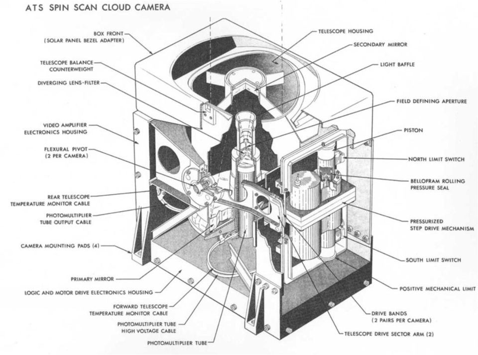
17 First geostationary weather satellite December 6, 1966 Applications Technology Satellite-1 (ATS-1) launched. First image shown below for December 22. Took advantage of spin-scan technology developed by Professor Suomi. Successive East-to-west scans. Full disk visible images! Movies! This astounded meteorologists. Now the clouds move, not the satellite Professor Suomi Artist conception of ATS-1

18
19 Repercussions and evolution of satellites next ten years DOD started satellite program in the Defense Meteorological Satellite Program (DMSP) Aircraft reconnaissance begins to be reduced globally, ultimately leaving only Atlantic reconnaissance by 1987 In 1972, Vern Dvorak develops technique to estimate hurricane intensity based on cloud shape and banding 1972 also marks beginning of multichannel sensing in different wavelengths of electromagnetic spectrum on NOAA-2 Geostationary becomes officially operational in a. Prototype - Synchronous Meteorological Satellites (SMS) b. In 1975 Geostationary Operational Environmental Satellite (GOES) Causes end of U.S. weather observation ship program in 1977, relying on volunteer reports from commercial ships Other countries launch satellites (Europe METEOSAT) (Japan, GMS) SEASAT scatterometer in 1978

20 Original Dvorak Technique

21 Tracking of tropical waves from Africa!
22
23
24
25 Scatterometers Seasat 1978 Indirectly measures surface wind speed by emitting microwave radiation toward the ocean and computes the amount of radiation scattered by short, centimeter-scale (capillary) ocean waves. Microwave can see through non-convective clouds

26

27
28
29 Other clever uses of microwave 1987 DOD s Special Sensor Microwave/Imager (SSM/I) a. Sensitivity to convective clouds allows detection of hurricane structure, especially eyewalls and spiral bands b. Also can estimate surface wind speed c. Water temperature estimates 1997 Tropical Rainfall Measuring Mission (TRMM) a. Spaceborne radar measures rainfall b. Microwave Imager measures vertical distribution of moisture c. Three-times resolution of SSM/I 1998 Advanced Microwave Sounding Unit (AMSU) a. Captures 3D structure of hurricanes b. Warm-core measured c. Can infer wind profiles, surface pressure
30 More information AMS 2010 Conference Symposium on Meteorological Satellites Observing Systems: From 50 years ago to 15 years ahead Also see:
31
32
33
34
35
36
37
Presented by Gary Davis, Director, Office of Systems Development NOAA/NESDIS/OSD. Fifty Years of Achievement
 NOAA s Environmental Satellite Program: Past, Present, and Future Presented by Gary Davis, Director, Office of Systems Development NOAA/NESDIS/OSD 1 Space-Based Remote Sensors Changed Way We See Our World
Clouds and the Energy Cycle
 August 1999 NF-207 The Earth Science Enterprise Series These articles discuss Earth's many dynamic processes and their interactions Clouds and the Energy Cycle he study of clouds, where they occur, and
Joint Polar Satellite System (JPSS)
") Joint Polar Satellite System (JPSS) John Furgerson, User Liaison Joint Polar Satellite System National Environmental Satellite, Data, and Information Service National Oceanic and Atmospheric Administration
Joint Polar Satellite System (JPSS) John Furgerson, User Liaison Joint Polar Satellite System National Environmental Satellite, Data, and Information Service National Oceanic and Atmospheric Administration
NCDC s SATELLITE DATA, PRODUCTS, and SERVICES
 **** NCDC s SATELLITE DATA, PRODUCTS, and SERVICES Satellite data and derived products from NOAA s satellite systems are available through the National Climatic Data Center. The two primary systems are
What s better than a milliondollar
 F o r k i d s o f a l l a g e s BY MEMORIE YASUDA What s better than a milliondollar view from the top of a skyscraper? Try a multimillion-dollar view from a satellite flying around Earth. A satellite
Remote Sensing Satellite Information Sheets Geophysical Institute University of Alaska Fairbanks
 Remote Sensing Satellite Information Sheets Geophysical Institute University of Alaska Fairbanks ASTER Advanced Spaceborne Thermal Emission and Reflection Radiometer AVHRR Advanced Very High Resolution
Estimating Firn Emissivity, from 1994 to1998, at the Ski Hi Automatic Weather Station on the West Antarctic Ice Sheet Using Passive Microwave Data
 Estimating Firn Emissivity, from 1994 to1998, at the Ski Hi Automatic Weather Station on the West Antarctic Ice Sheet Using Passive Microwave Data Mentor: Dr. Malcolm LeCompte Elizabeth City State University
TECHNICAL REPORTS. Authors: Tatsuhiro Noguchi* and Takaaki Ishikawa*
 Application and Evaluation of Observation Data by Advanced Microwave Scanning Radiometer 2 Achievement of World s Top-Class Microwave Radiometer AMSR Series Authors: Tatsuhiro Noguchi* and Takaaki Ishikawa*
Overview of the IR channels and their applications
 Ján Kaňák Slovak Hydrometeorological Institute Jan.kanak@shmu.sk Overview of the IR channels and their applications EUMeTrain, 14 June 2011 Ján Kaňák, SHMÚ 1 Basics in satellite Infrared image interpretation
How Do You Make a Weather Satellite?
 NATIONAL OCEANIC AND ATMOSPHERIC ADMINISTRATION U.S. DEPARTMENT OF COMMERCE How Do You Make a Weather Satellite? This booklet was adapted from the original work by Ed Koenig I'm a weather forecaster. I
http://www.nrl.navy.mil/pao/pressrelease.php?y=2008&r=91-08r
 Page 1 of 7 NRL Press Release 91-08r 12/15/2008 nrlpao@nrl.navy.mil 202-767-2541 NRL's P-3 Aircraft Support Project to Study Tropical Cyclones Email Follow NRL RSS Feed Related Visuals The Naval Research
CHAPTER 1 EVOLUTION OF SATELLITE METEOROLOGY
 CHAPTER 1 EVOLUTION OF SATELLITE METEOROLOGY 1.1 Before satellites Since colonial times, the interest in today s weather and predicting tomorrow s has led to attempts at sensing the earth's atmosphere.
Weather Radar Basics
 Weather Radar Basics RADAR: Radio Detection And Ranging Developed during World War II as a method to detect the presence of ships and aircraft (the military considered weather targets as noise) Since WW
History of the NOAA Satellite Program
 History of the NOAA Satellite Program Gary Davis NOAA Satellite and Information Service 1335 East-West Highway, Silver Spring, Maryland, 20910, USA www.osd.noaa.gov Abstract For more than 50 years, NOAA
Precipitation Remote Sensing
 Precipitation Remote Sensing Huade Guan Prepared for Remote Sensing class Earth & Environmental Science University of Texas at San Antonio November 14, 2005 Outline Background Remote sensing technique
Sputnik and the Space Race. By: AJ Scangamor and Joseph Reed
 Sputnik and the Space Race By: AJ Scangamor and Joseph Reed Background After WWII ended the Cold War had just begun. Within this war between two great powers competed in the battle of the Space Race, the
USING THE GOES 3.9 µm SHORTWAVE INFRARED CHANNEL TO TRACK LOW-LEVEL CLOUD-DRIFT WINDS ABSTRACT
 USING THE GOES 3.9 µm SHORTWAVE INFRARED CHANNEL TO TRACK LOW-LEVEL CLOUD-DRIFT WINDS Jason P. Dunion 1 and Christopher S. Velden 2 1 NOAA/AOML/Hurricane Research Division, 2 UW/CIMSS ABSTRACT Low-level
Active and Passive Microwave Remote Sensing
 Active and Passive Microwave Remote Sensing Passive remote sensing system record EMR that was reflected (e.g., blue, green, red, and near IR) or emitted (e.g., thermal IR) from the surface of the Earth.
A remote sensing instrument collects information about an object or phenomenon within the
 Satellite Remote Sensing GE 4150- Natural Hazards Some slides taken from Ann Maclean: Introduction to Digital Image Processing Remote Sensing the art, science, and technology of obtaining reliable information
Tropical Cyclone Report Hurricane Fausto (EP072008) 16-22 July 2008. John L. Beven II National Hurricane Center 19 November 2008
 16-22 July 2008. John L. Beven II National Hurricane Center 19 November 2008") Tropical Cyclone Report Hurricane Fausto (EP072008) 16-22 July 2008 John L. Beven II National Hurricane Center 19 November 2008 Fausto was a category 1 hurricane on the Saffir-Simpson Hurricane Scale that
Tropical Cyclone Report Hurricane Fausto (EP072008) 16-22 July 2008 John L. Beven II National Hurricane Center 19 November 2008 Fausto was a category 1 hurricane on the Saffir-Simpson Hurricane Scale that
Ensuring the Preparedness of Users: NOAA Satellites GOES R, JPSS Laura K. Furgione
 Ensuring the Preparedness of Users: NOAA Satellites GOES R, JPSS Laura K. Furgione U.S. Permanent Representative with the WMO Deputy Director, NOAA s s National Weather Service WMO Executive Council 65
Hyperspectral Satellite Imaging Planning a Mission
 Hyperspectral Satellite Imaging Planning a Mission Victor Gardner University of Maryland 2007 AIAA Region 1 Mid-Atlantic Student Conference National Institute of Aerospace, Langley, VA Outline Objective
Follow That Hurricane!
 Discover Your World With NOAA Follow That Hurricane! What You Will Do Devastating damage expected A most Track a hurricane on the same powerful hurricane with unprecedented type of chart used at the strength
SPACE WEATHER SUPPORT FOR COMMUNICATIONS. Overview
 SPACE WEATHER SUPPORT FOR COMMUNICATIONS Overview Ionospheric variability (space weather) significantly impacts ground and space-based communications. In essence, the electrically charged particles of
What is spectrum reallocation, and what does it have to do with weather satellites?
 FAQ ========= SPECTRUM REALLOCATION ========= What is spectrum reallocation, and what does it have to do with weather satellites? Because of increasing demand for wireless smartphones, tablets, and Wi-Fi
CHAPTER 2 Energy and Earth
 CHAPTER 2 Energy and Earth This chapter is concerned with the nature of energy and how it interacts with Earth. At this stage we are looking at energy in an abstract form though relate it to how it affect
REMOTE SENSING AND ENVIRONMENTAL MONITORING. P. M. Mather School of Geography, The University of Nottingham, U.K.
 REMOTE SENSING AND ENVIRONMENTAL MONITORING P. M. Mather School of Geography, The University of Nottingham, U.K. Keywords: Earth observation, image processing, lidar, pattern recognition, radar Contents
Mapping Earth from Space Remote sensing and satellite images. Remote sensing developments from war
 Mapping Earth from Space Remote sensing and satellite images Geomatics includes all the following spatial technologies: a. Cartography "The art, science and technology of making maps" b. Geographic Information
RESULTS FROM A SIMPLE INFRARED CLOUD DETECTOR
 RESULTS FROM A SIMPLE INFRARED CLOUD DETECTOR A. Maghrabi 1 and R. Clay 2 1 Institute of Astronomical and Geophysical Research, King Abdulaziz City For Science and Technology, P.O. Box 6086 Riyadh 11442,
A Microwave Retrieval Algorithm of Above-Cloud Electric Fields
 A Microwave Retrieval Algorithm of Above-Cloud Electric Fields Michael J. Peterson The University of Utah Chuntao Liu Texas A & M University Corpus Christi Douglas Mach Global Hydrology and Climate Center
1 In this report, "tropical cyclone (TC)" is used as a generic term that includes "low pressure area (LPA)", "tropical depression
 is used as a generic term that includes low pressure area (LPA), tropical depression") Comparative Study on Organized Convective Cloud Systems detected through Early Stage Dvorak Analysis and Tropical Cyclones in Early Developing Stage in the Western North Pacific and the South China Sea
Comparative Study on Organized Convective Cloud Systems detected through Early Stage Dvorak Analysis and Tropical Cyclones in Early Developing Stage in the Western North Pacific and the South China Sea
Thomas Fiolleau Rémy Roca Frederico Carlos Angelis Nicolas Viltard. www.satmos.meteo.fr
 Comparison of tropical convective systems life cycle characteristics from geostationary and TRMM observations for the West African, Indian and South American regions Thomas Fiolleau Rémy Roca Frederico
16 th IOCCG Committee annual meeting. Plymouth, UK 15 17 February 2011. mission: Present status and near future
 16 th IOCCG Committee annual meeting Plymouth, UK 15 17 February 2011 The Meteor 3M Mt satellite mission: Present status and near future plans MISSION AIMS Satellites of the series METEOR M M are purposed
http://www.isac.cnr.it/~ipwg/
 The CGMS International Precipitation Working Group: Experience and Perspectives Vincenzo Levizzani CNR-ISAC, Bologna, Italy and Arnold Gruber NOAA/NESDIS & Univ. Maryland, College Park, MD, USA http://www.isac.cnr.it/~ipwg/
STAAR Science Tutorial 30 TEK 8.8C: Electromagnetic Waves
 Name: Teacher: Pd. Date: STAAR Science Tutorial 30 TEK 8.8C: Electromagnetic Waves TEK 8.8C: Explore how different wavelengths of the electromagnetic spectrum such as light and radio waves are used to
Remote Sensing. Vandaag. Voordelen Remote Sensing Wat is Remote Sensing? Vier elementen Remote Sensing systeem
 Remote Sensing 1 Vandaag Voordelen Remote Sensing Wat is Remote Sensing? Vier elementen Remote Sensing systeem 2 Nederland Vanaf 700 km hoogte Landsat TM mozaïek 3 Europa vanaf 36000 km hoogte 4 5 Mount
Hurricanes. Characteristics of a Hurricane
 Hurricanes Readings: A&B Ch. 12 Topics 1. Characteristics 2. Location 3. Structure 4. Development a. Tropical Disturbance b. Tropical Depression c. Tropical Storm d. Hurricane e. Influences f. Path g.
Sources of Space Policy and Law
 Sources of Space Policy and Law Custom Domestic and International Laws Treaties and Agreements Policy Statements and Directives - Presidential - DoD and The Armed Services - Other Government Organizations
THE NATIONAL SPACE WEATHER PROGRAM
 1 Office of the Federal Coordinator for Meteorological Services and Supporting Research (OFCM) THE NATIONAL SPACE WEATHER PROGRAM Committee on Solar and Space Physics National Research Council Space Studies
ESCI 107/109 The Atmosphere Lesson 2 Solar and Terrestrial Radiation
 ESCI 107/109 The Atmosphere Lesson 2 Solar and Terrestrial Radiation Reading: Meteorology Today, Chapters 2 and 3 EARTH-SUN GEOMETRY The Earth has an elliptical orbit around the sun The average Earth-Sun
SIXTH GRADE WEATHER 1 WEEK LESSON PLANS AND ACTIVITIES
 SIXTH GRADE WEATHER 1 WEEK LESSON PLANS AND ACTIVITIES WATER CYCLE OVERVIEW OF SIXTH GRADE WATER WEEK 1. PRE: Evaluating components of the water cycle. LAB: Experimenting with porosity and permeability.
Our Antarctic Facilities
 Our Antarctic Facilities Australian Activities in Antarctica Tony Worby IICWG Chile, October 2014 3 days Macquarie Island Wilkins aerodrome Hobart is Australia s Gateway to East Antarctica and the Southern
Chapter Contents Page No
 Chapter Contents Page No Preface Acknowledgement 1 Basics of Remote Sensing 1 1.1. Introduction 1 1.2. Definition of Remote Sensing 1 1.3. Principles of Remote Sensing 1 1.4. Various Stages in Remote Sensing
Review for Introduction to Remote Sensing: Science Concepts and Technology
 Review for Introduction to Remote Sensing: Science Concepts and Technology Ann Johnson Associate Director ann@baremt.com Funded by National Science Foundation Advanced Technological Education program [DUE
Current status and Future Prospects of Indian Satellite
 Current status and Future Prospects of Indian Satellite Devendra singh and Sanjiv Nair Ministry of science and Technology Department of Science and technology Technology Bhawan,New Mehrauli Road, New Delhi-110016
TELESCOPE AS TIME MACHINE
 TELESCOPE AS TIME MACHINE Read this article about NASA s latest high-tech space telescope. Then, have fun doing one or both of the word puzzles that use the important words in the article. A TELESCOPE
CME 574 Satellite Communications
 CME 574 Satellite Communications Fall, 2007 Dr Hazem Al-Otum Ref. Ellwood Brem, Instructor To orbit the Earth is to fall down and miss the ground! Topics we will cover: History Satellite Mechanics Orbital
Swarthmore College Newsletter
 93 Fog, clouds, and light pollution limit the effectiveness of even the biggest optical telescopes on Earth. Astronomers who study ultraviolet or X-ray emission of stars have been more limited because
1. Introduction. FER-Zagreb, Satellite communication systems 2011/12
 1. Introduction Topics History Characteristics of satellite communications Frequencies Application 1 History Arthur C. Clark suggested in 1945. Earth coverage with 3 geostationary satellites. On 4th of
Two primary advantages of radars: all-weather and day /night imaging
 Lecture 0 Principles of active remote sensing: Radars. Objectives: 1. Radar basics. Main types of radars.. Basic antenna parameters. Required reading: G: 8.1, p.401-40 dditional/advanced reading: Online
SATELLITE IMAGES IN ENVIRONMENTAL DATA PROCESSING
 SATELLITE IMAGES IN ENVIRONMENTAL DATA PROCESSING Magdaléna Kolínová Aleš Procházka Martin Slavík Prague Institute of Chemical Technology Department of Computing and Control Engineering Technická 95, 66
Daily High-resolution Blended Analyses for Sea Surface Temperature
 Daily High-resolution Blended Analyses for Sea Surface Temperature by Richard W. Reynolds 1, Thomas M. Smith 2, Chunying Liu 1, Dudley B. Chelton 3, Kenneth S. Casey 4, and Michael G. Schlax 3 1 NOAA National
REDEVELOPING A MULTIMEDIA TRAINING MODULE AS PART OF A WWW-BASED EUROPEAN SATELLITE METEOROLOGY COURSE
 Redeveloping a Multimedia Training Module as Part of a WWW-Based European Satellite Meteorology Course REDEVELOPING A MULTIMEDIA TRAINING MODULE AS PART OF A WWW-BASED EUROPEAN SATELLITE METEOROLOGY COURSE
Saharan Dust Aerosols Detection Over the Region of Puerto Rico
 1 Saharan Dust Aerosols Detection Over the Region of Puerto Rico ARLENYS RAMÍREZ University of Puerto Rico at Mayagüez, P.R., 00683. Email:arlenys.ramirez@upr.edu ABSTRACT. Every year during the months
The Balance of Power in the Earth-Sun System
 NASA Facts National Aeronautics and Space Administration www.nasa.gov The Balance of Power in the Earth-Sun System The Sun is the major source of energy for Earth s oceans, atmosphere, land, and biosphere.
The NOAA National Climatic Data Center Data availability, WDC-A, and GCOS data sets
 NEESPI Regional Science Team Meeting, Helsinki, Finland 2-6 June 2008 The NOAA National Climatic Data Center Data availability, WDC-A, and GCOS data sets Dr. Karsten A. Shein Data Quality Administrator
Cloud Grid Information Objective Dvorak Analysis (CLOUD) at the RSMC Tokyo - Typhoon Center
 at the RSMC Tokyo - Typhoon Center") Cloud Grid Information Objective Dvorak Analysis (CLOUD) at the RSMC Tokyo - Typhoon Center Kenji Kishimoto, Masaru Sasaki and Masashi Kunitsugu Forecast Division, Forecast Department Japan Meteorological
Cloud Grid Information Objective Dvorak Analysis (CLOUD) at the RSMC Tokyo - Typhoon Center Kenji Kishimoto, Masaru Sasaki and Masashi Kunitsugu Forecast Division, Forecast Department Japan Meteorological
Environmental Data Services for Delaware:
 Environmental Data Services for Delaware: Serving Emergency Responders, Planners, and Researchers Network Delaware Day November 6, 2013 Overview Operational Data Services More than just research DEOS and
Re: Ex Parte submission in IB Docket No. 12 340; RM 11681 Petition for Rulemaking to Allocate the 1675 1680 MHz band for Terrestrial Mobile Use
 American Meteorological Society 45 Beacon Street Boston, MA 02108 National Weather Association 3100 Monitor Avenue, Suite 123 Norman, OK 73072 1 March 2016 Federal Communications Commission Ms. Marlene
Head 168 HONG KONG OBSERVATORY
 Controlling officer: the Director of the Hong Kong Observatory will account for expenditure under this Head. Estimate... $203.4m Establishment ceiling (notional annual mid-point salary value) representing
How Landsat Images are Made
 How Landsat Images are Made Presentation by: NASA s Landsat Education and Public Outreach team June 2006 1 More than just a pretty picture Landsat makes pretty weird looking maps, and it isn t always easy
How to analyze synoptic-scale weather patterns Table of Contents
 How to analyze synoptic-scale weather patterns Table of Contents Before You Begin... 2 1. Identify H and L pressure systems... 3 2. Locate fronts and determine frontal activity... 5 3. Determine surface
Studying cloud properties from space using sounder data: A preparatory study for INSAT-3D
 Studying cloud properties from space using sounder data: A preparatory study for INSAT-3D Munn V. Shukla and P. K. Thapliyal Atmospheric Sciences Division Atmospheric and Oceanic Sciences Group Space Applications
UNCLASSIFIED FY 2015. Quantity of RDT&E Articles 0.000 - - - - - - - - - MDAP/MAIS Code: 488
 Exhibit R-2, RDT&E Budget Item Justification: PB 2015 Air Force : March 2014 3600: Research, Development, Test & Evaluation, Air Force / BA 4: Advanced Component Development & Prototypes (ACD&P) COST ($
Chapter 3: Weather Map. Weather Maps. The Station Model. Weather Map on 7/7/2005 4/29/2011
 Chapter 3: Weather Map Weather Maps Many variables are needed to described weather conditions. Local weathers are affected by weather pattern. We need to see all the numbers describing weathers at many
Integrated Systems since 1990. Company Profile. BKC WeatherSys Pvt. Ltd. New Delhi, India
 Company Profile BKC WeatherSys Pvt. Ltd. New Delhi, India Corporate Office: 32/33, Kusal Bazar, Nehru Place, New Delhi, India Project Office: H-135, Sector 63, Noida, Uttar Pradesh, India www.weathersysbkc.com
Nowcasting Thunderstorm Potential from Satellite
 Nowcasting Thunderstorm Potential from Satellite Robert M Rabin NOAA/National Severe Storms Laboratory Norman, OK USA Cooperative Institute for Meteorological Satellite Studies University of Wisconsin
High Resolution Information from Seven Years of ASTER Data
 High Resolution Information from Seven Years of ASTER Data Anna Colvin Michigan Technological University Department of Geological and Mining Engineering and Sciences Outline Part I ASTER mission Terra
SATELLITE TECHNOLOGY STUDENT INFORMATION
 SATELLITE TECHNOLOGY STUDENT INFORMATION Area of Study: Communications Objectives: Students will discover the basic principles of satellite technology through a demonstration and utilization of web resources.
International coordination for continuity and interoperability: a CGMS perspective
 International coordination for continuity and interoperability: a CGMS perspective Peng Zhang, CGMS WG-III Co-Chair NSMC/CMA In Cooperation with Suzanne Hilding, CGMS WG-III Co-Chair OPPA/NESDIS/NOAA 1
Chapter 2: Solar Radiation and Seasons
 Chapter 2: Solar Radiation and Seasons Spectrum of Radiation Intensity and Peak Wavelength of Radiation Solar (shortwave) Radiation Terrestrial (longwave) Radiations How to Change Air Temperature? Add
Storms Short Study Guide
 Name: Class: Date: Storms Short Study Guide Multiple Choice Identify the letter of the choice that best completes the statement or answers the question. 1. A(n) thunderstorm forms because of unequal heating
Name Period 4 th Six Weeks Notes 2015 Weather
 Name Period 4 th Six Weeks Notes 2015 Weather Radiation Convection Currents Winds Jet Streams Energy from the Sun reaches Earth as electromagnetic waves This energy fuels all life on Earth including the
Mid latitude Cyclonic Storm System. 08 _15 ab. jpg
 Mid latitude Cyclonic Storm System 08 _15 ab. jpg Mid Latitude Cyclone Storm System (MLCSS) It has several names. Cyclone, Cyclonic Storm, Cyclonic System, Depression. Cyclonic Storms are the weather maker
Georgia Performance Standards Framework for Science Grade 6. Unit Organizer: UNIVERSE AND SOLAR SYSTEM (Approximate Time 3 Weeks)
") The following instructional plan is part of a GaDOE collection of Unit Frameworks, Performance Tasks, examples of Student Work, and Teacher Commentary. Many more GaDOE approved instructional plans are
The following instructional plan is part of a GaDOE collection of Unit Frameworks, Performance Tasks, examples of Student Work, and Teacher Commentary. Many more GaDOE approved instructional plans are
Establishing a Geospatial Intelligence Pipeline through Earth SySTEM Education
 Establishing a Geospatial Intelligence Pipeline through Earth SySTEM Education NOAA/NESDIS CoRP Science Symposium University of Maryland September 17, 2015 Peter Dorofy dorofyp@students.rowan.edu Rouzbeh
A.P. Cracknell Department of Electronic Engineering and Physics, University of Dundee, U.K.
 SATELLITE REMOTE SENSING A.P. Cracknell Department of Electronic Engineering and Physics, University of Dundee, U.K. Keywords: Satellites, satellite programs, applications, future systems Contents 1. Introduction
Materials: Internet connection and browser for displaying the lesson; Reading Guide (appended at the end of this lesson plan).
.") Multiwavelength Astronomy: The History of X-ray Astronomy, by Herbert Friedman http://ecuip.lib.uchicago.edu/multiwavelength-astronomy/x-ray/history/index.html Subject(s): Astronomy/Space Science Grade(s)
Multiwavelength Astronomy: The History of X-ray Astronomy, by Herbert Friedman http://ecuip.lib.uchicago.edu/multiwavelength-astronomy/x-ray/history/index.html Subject(s): Astronomy/Space Science Grade(s)
Atmospheric Dynamics of Venus and Earth. Institute of Geophysics and Planetary Physics UCLA 2 Lawrence Livermore National Laboratory
 Atmospheric Dynamics of Venus and Earth G. Schubert 1 and C. Covey 2 1 Department of Earth and Space Sciences Institute of Geophysics and Planetary Physics UCLA 2 Lawrence Livermore National Laboratory
GLOBAL FORUM London, October 24 & 25, 2012
 GLOBAL FORUM London, October 24 & 25, 2012-1 - Global Observations of Gas Flares Improving Global Observations of Gas Flares With Data From the Suomi NPP Visible Infrared Imaging Radiometer Suite (VIIRS)
ADAGUC & PyTROLL. Maarten Plieger Ernst de Vreede. Application of polar orbiter products in weather forecasting Using open source tools and standards
 Application of polar orbiter products in weather forecasting Using open source tools and standards ADAGUC & PyTROLL Maarten Plieger Ernst de Vreede Royal Netherlands Meteorological Institute (KNMI) R&D
Passive Microwave Remote Sensing for Sea Ice Thickness Retrieval Using Neural Network and Genetic Algorithm
 Progress In Electromagnetics Research Symposium, Beijing, China, March 23 27, 2009 229 Passive Microwave Remote Sensing for Sea Ice Thickness Retrieval Using Neural Network and Genetic Algorithm H. J.
Passive and Active Microwave Remote Sensing of Cold-Cloud Precipitation : Wakasa Bay Field Campaign 2003
 Passive and Active Microwave Remote Sensing of Cold-Cloud Precipitation : Wakasa Bay Field Campaign 3 Benjamin T. Johnson,, Gail Skofronick-Jackson 3, Jim Wang 3, Grant Petty jbenjam@neptune.gsfc.nasa.gov
Introduction. Stefano Ferrari. Università degli Studi di Milano stefano.ferrari@unimi.it. Elaborazione delle immagini (Image processing I)
") Introduction Stefano Ferrari Università degli Studi di Milano stefano.ferrari@unimi.it Elaborazione delle immagini (Image processing I) academic year 2011 2012 Image processing Computer science concerns
Introduction Stefano Ferrari Università degli Studi di Milano stefano.ferrari@unimi.it Elaborazione delle immagini (Image processing I) academic year 2011 2012 Image processing Computer science concerns
Indian Diplomacy At Work
 Indian Diplomacy At Work 50 YEARS OF INDO-FRENCH SPACE CO-OPERATION BRINGING BENEFITS TO MANKIND 50 YEARS OF INDO-FRENCH SPACE CO-OPERATION Bringing Benefits to Mankind A time-tested partnership India
User's Guide for Building and Operating Environmental Satellite Receiving Stations
 National Oceanic and Atmospheric Administration User's Guide for Building and Operating Environmental Satellite Receiving Stations Updated: February 2009 U.S. DEPARTMENT OF COMMERCE National Oceanic and
Chapter 3: Weather Map. Station Model and Weather Maps Pressure as a Vertical Coordinate Constant Pressure Maps Cross Sections
 Chapter 3: Weather Map Station Model and Weather Maps Pressure as a Vertical Coordinate Constant Pressure Maps Cross Sections Weather Maps Many variables are needed to described dweather conditions. Local
ATM S 111, Global Warming: Understanding the Forecast
 ATM S 111, Global Warming: Understanding the Forecast DARGAN M. W. FRIERSON DEPARTMENT OF ATMOSPHERIC SCIENCES DAY 1: OCTOBER 1, 2015 Outline How exactly the Sun heats the Earth How strong? Important concept
An A-Train Water Vapor Thematic Climate Data Record Using Cloud Classification
 An A-Train Water Vapor Thematic Climate Data Record Using Cloud Classification Eric J. Fetzer, Qing Yue, Alexandre Guillaume, Van T. Dang, Calvin Liang, Brian H. Kahn, Brian D. Wilson, Bjorn H. Lambrigtsen
Remote Sensing an Introduction
 Remote Sensing an Introduction Seminar: Space is the Place Referenten: Anica Huck & Michael Schlund Remote Sensing means the observation of, or gathering information about, a target by a device separated
CHAPTER 6 INSTRUMENTATION AND MEASUREMENTS 6.1 MEASUREMENTS
 CHAPTER 6 INSTRUMENTATION AND MEASUREMENTS 6.1 MEASUREMENTS Atmospheric electricity is a field that is very easy to get into because it does not require a large capital investment for measuring equipment.
NASA Earth Science Research Results Enhance Public Health Science For Society
 NASA Earth Science Research Results Enhance Public Health Science For Society John A. Haynes Program Manager, Public Health Applied Sciences Program Science Mission Directorate NASA Washington, DC USA
Estimating Surface Oil Extent from the Deepwater Horizon Oil Spill using ASCAT Backscatter
 Estimating Surface Oil Extent from the Deepwater Horizon Oil Spill using ASCAT Backscatter Richard D. Lindsley and David G. Long Microwave Earth Remote Sensing Laboratory Brigham Young University Provo,
Environmental Monitoring: Guide to Selecting Wireless Communication Solutions
 Environmental Monitoring: Guide to Selecting Wireless Communication Solutions By: Scott South Published in WaterWorld, January 2005 (Page 48) Rapidly growing demands for information and increased productivity
Summary Report on National and Regional Projects set-up in Russian Federation to integrate different Ground-based Observing Systems
 WORLD METEOROLOGICAL ORGANIZATION COMMISSION FOR INSTRUMENT AND METHODS OF OBSERVATION OPAG-UPPER AIR EXPERT TEAM ON REMOTE SENSING UPPER-AIR TECHNOLOGY AND TECHNIQUES First Session Geneva, Switzerland,
Description of Scatterometer Data Products
 Scatterometer Data:// Description of Scatterometer Data Products QuikScat is no longer operational - last data recorded: 2009-Nov-23 REMSS QuikScat data set currently ends on 2009-11-19; data after that
NASA Earth System Science: Structure and data centers
 SUPPLEMENT MATERIALS NASA Earth System Science: Structure and data centers NASA http://nasa.gov/ NASA Mission Directorates Aeronautics Research Exploration Systems Science http://nasascience.nasa.gov/
and Data Utilization Strategy
 Japan's Earth Observation Satellite Development Plan and Data Utilization Strategy July 2005 Special Subcommittee on Earth Observation Space Activities Commission Contents 1. Introduction... 1 2. Present
Suomi / NPP Mission Applications Workshop Meeting Summary
 Suomi / NPP Mission Applications Workshop Meeting Summary Westin City Center, Washington, DC June 21-22, 2012 Draft Report (updated March 12, 2013) I. Background The Suomi National Polar- orbiting Partnership
California Standards Grades 9 12 Boardworks 2009 Science Contents Standards Mapping
 California Standards Grades 912 Boardworks 2009 Science Contents Standards Mapping Earth Sciences Earth s Place in the Universe 1. Astronomy and planetary exploration reveal the solar system s structure,