Bhuvan. Indian Earth Observation Visualization. Indian Space Research Organisation. Multi Resolution. Societal Applications
|
|
|
- Coral Norris
- 9 years ago
- Views:
Transcription
1 Multi Resolution Bhuvan Societal Applications Indian Earth Observation Visualization 3D Geographic Models Seamless Fly Through Indian Space Research Organisation Thematic Vectors UN-COPUOS Scientific and Technical Subcommittee, 47 th Session Vienna, February 08-19, 2010

2 Vision To evince the distinctiveness of Indian imaging capabilities through online rendering of multi- resolution, multi-temporal and multi-sensor IRS imagery overlaying value added thematic maps on 3D globe whilst serving for societal good. Integrated into everyday decision making

3 What is Bhuvan? Primarily a EO visualization tool Indian remote sensing satellite imagery based geoportal, representing in essence, the whole India on a computer Enables users to "fly" from space to street level to find geographic information and explore places around India Like a video game and a search engine rolled into one ease of use A 3D model of India that lets you grab, spin and zoom down into any place User Satisfaction is our Mission

4 Bhuvan: Genesis and Intent A Geoportal of Indian Space Research Organisation Showcase Indian Imaging Capabilities in Multi sensor, Multi platform and Multitemporal geospatial domain A gateway to explore and discover virtual earth in 3D space Specific emphasis on Indian region and utility for society Premiered in Aug 2009

5 Typical Objectives Highlights Visualization of IRS images on 3D Globe Support for 2D and 3D client tools & utilities Display of geospatial raster and vector layers Scalable solution, commensurate with the vision Optimised solution - Large no. of concurrent users System design and architecture Distributed comp. Challenges Server side - H/W, S/W, Security and Networking.. Application S/W - Server side & client side dev. Database organisation, Standards, implementation.. Content generation, deployment & management Quality Assurance (s/w, geometry & Radiometry)

6 Broad Areas of Development Features - client side and server side solutions Three Tier Architecture Value addition in Client-end functionalities Server-end challenges - operations/ services Hardware requirements analysis & design Metadata preparation and cataloguing Raster and Vector data standards & preparation Database Organisation and design Analysis for optimal performance - simulations Road Map - Short term & Long term

7 Bhuvan Design - Challenges Cater to large no. of users concurrently - efficient streaming Application software solution - adaptable/scalable To meet large concurrent users demands - design issues Customisation of client-end s/w - Design & development Optimal database design, preparation & management Multi-resolution, multi-sensor, multi-temporal data mgt. High Quality image Geo-referencing Automation Variable sized Tiles/ Mosaics for optimal services Radiometric normalisation for virtual seamlessness Large volume of data processing/ storage/ updates Large number of Vector layers - Themes/ infrastructure Vector data overlay on images and query/ info. extraction Innovative value addition /research - software & services

8 Bhuvan Architecture Users Satellite Data Optimized Data storage Data Streaming Application Raster / Vector Data Security Elevation Data Load Balancing Internet Thematic Data Users

9 Bhuvan Hardware Set up

10 Salient Features of Application Software Server Client Simple Browser based client even for 3D globe Optimized to work with client bandwidth limitations

11 Databases for Bhuvan

12 Data as per RSDP Data on Bhuvan AWiFS for entire world AWiFS Full India (Three seasons of 2008) LISS-III Mosaic for India (2007) Synthatic L4MX (IRS-1C/1D PAN + LISS-III) covering entire India IRS-P6 LISS-4 coveringwestern part of India OCM Full India mosaic. Administrative Boundaries Country State District Taluk Village Thematic Information Wasteland Data Soil Ground Water Prospects Value added Information Watershed Boundary Weather Parameters (AWS) Disaster Specific Datasets (Flood & Drought) IRS P6 L4MX for full India. IRS P6 L4MX some Foreign cities. Full India LISS III Mosaic for 2008
 Disaster Specific Datasets (Flood & Drought) IRS P6 L4MX for full India.")
13 Distinctive Attributes A complete net centric 3D visualization solution Solution using optimal Web Cache and data streaming Server Customised client/browser based utilities 3D Visualization in browse Create, view, analyze, and share 3D environments Highly scalable architecture & open standards Feature rich 3D object tools Rich thematic information Focus on societal applications Current events update

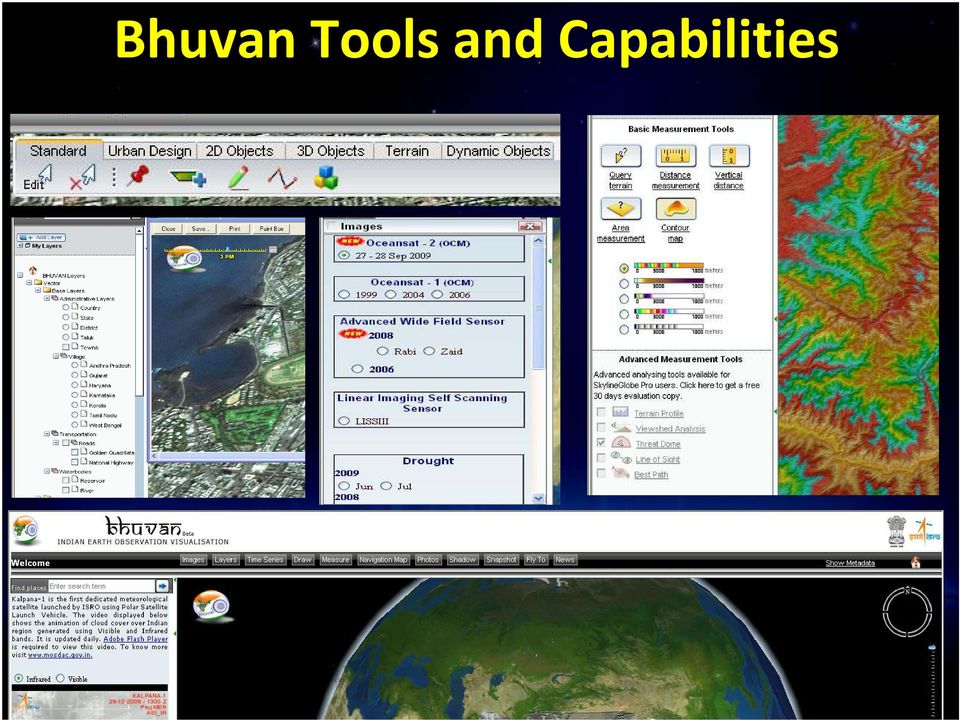
14 Bhuvan Tools and Capabilities
15 ISRO Bhuvan Typical Screen shots

16 Bhuvan goes Global 3D view of our planet

17 Part of Vienna city in Bhuvan

18 Part of Vienna city in Bhuvan

19 Video Demo

Keystone Image Management System
 Image management solutions for satellite and airborne sensors Overview The Keystone Image Management System offers solutions that archive, catalogue, process and deliver digital images from a vast number
INTEROPERABLE IMAGE DATA ACCESS THROUGH ARCGIS SERVER
 INTEROPERABLE IMAGE DATA ACCESS THROUGH ARCGIS SERVER Qian Liu Environmental Systems Research Institute 380 New York Street Redlands, CA92373, U.S.A - [email protected] KEY WORDS: OGC, Standard, Interoperability,
Developing Fleet and Asset Tracking Solutions with Web Maps
 Developing Fleet and Asset Tracking Solutions with Web Maps Introduction Many organizations have mobile field staff that perform business processes away from the office which include sales, service, maintenance,
Vinay K Dadhwal Director. 50 th Session of Scientific & Technical Subcommittee of COPUOS, 11-22 Feb., 2013, Vienna
 Vinay K Dadhwal Director 50 th Session of Scientific & Technical Subcommittee of COPUOS, 11-22 Feb., 2013, Vienna Demonstrated applications of EO for natural resources, infrastructure, planning & disaster
Enterprise GIS Solutions to GIS Data Dissemination
 Enterprise GIS Solutions to GIS Data Dissemination ESRI International User Conference July 13 17, 2009 Wendy M. Turner Senior GIS Engineer & Program Manager Freedom Consulting Group, LLC Building the Enterprise
Google Earth Digitale Wege in eine bekannte Welt Sep. 2006
 Google Earth Digitale Wege in eine bekannte Welt Sep. 2006 Joachim Glaubrecht Google Enterprise [email protected] What is Google Enterprise? 2 1 Focus.de: "Der Papst-Besuch in Google Earth" 3 How to Geo
Gram Panchayat & Ward Boundary Delineation and Assets mapping
 Gram Panchayat & Ward Boundary Delineation and Assets mapping For Rural Development Department & State Election Commission, Govt. of Maharashtra MAHARASHTRA REMOTE SENSING APPLICATIONS CENTRE Autonomous
The needs on big data management for Operational Geo-Info Services: Emergency Response, Maritime surveillance, Agriculture Management
 Copernicus Big-Data Workshop 2014, 13/14 March The needs on big data management for Operational Geo-Info Services: Emergency Response, Maritime surveillance, Agriculture Management Marco Corsi e-geos 1
Advanced Image Management using the Mosaic Dataset
 Esri International User Conference San Diego, California Technical Workshops July 25, 2012 Advanced Image Management using the Mosaic Dataset Vinay Viswambharan, Mike Muller Agenda ArcGIS Image Management
ArcGIS. Server. A Complete and Integrated Server GIS
 ArcGIS Server A Complete and Integrated Server GIS ArcGIS Server A Complete and Integrated Server GIS ArcGIS Server enables you to distribute maps, models, and tools to others within your organization
Implementing an Imagery Management System at Mexican Navy
 Implementing an Imagery Management System at Mexican Navy The Mexican Navy safeguards 11,000 kilometers of Mexican coastlines, inland water bodies suitable for navigation, and the territorial sea and maritime
ArcGIS Data Models Practical Templates for Implementing GIS Projects
 ArcGIS Data Models Practical Templates for Implementing GIS Projects GIS Database Design According to C.J. Date (1995), database design deals with the logical representation of data in a database. The
Visualize your World. Democratization i of Geographic Data
 Visualize your World Democratization i of Geographic Data Session Agenda Google GEO Solutions - More than just a Map Enabling our Government Customers- Examples Summary & Invite to Learn More About Google
Introduction to Imagery and Raster Data in ArcGIS
 Esri International User Conference San Diego, California Technical Workshops July 25, 2012 Introduction to Imagery and Raster Data in ArcGIS Simon Woo slides Cody Benkelman - demos Overview of Presentation
AN OPENGIS WEB MAP SERVER FOR THE ESA MULTI-MISSION CATALOGUE
 AN OPENGIS WEB MAP SERVER FOR THE ESA MULTI-MISSION CATALOGUE T. Westin a, *, C. Caspar b, L. Edgardh a, L. Schylberg c a Spacemetric AB, Tingsv 19, 19161 Sollentuna, Sweden - [email protected] b ESA Esrin,
The Courses. Covering complete breadth of GIS technology from ESRI including ArcGIS, ArcGIS Server and ArcGIS Engine.
 ESRI India: Corporate profile ESRI India A profile India s Premier GIS Company Strategic alliance between ESRI Inc. and NIIT Technologies Adjudged as India s Best GIS Solutions Company - Map India 2001
MASS PROCESSING OF REMOTE SENSING DATA FOR ENVIRONMENTAL EVALUATION IN EUROPE
 MASS PROCESSING OF REMOTE SENSING DATA FOR ENVIRONMENTAL EVALUATION IN EUROPE Lic. Adrián González Applications Research Earth Science Conference 2014 29.07.2014 Earth Science San Conference Francisco
The Private Cloud Your Controlled Access Infrastructure
 White Paper: Private Clouds The ongoing debate on the differences between a Public and Private Cloud are broad and often loud. The bottom line is that it s really about how the resource, or computing power,
What's new in gvsig Desktop 2.0
 What's new in gvsig Desktop 2.0 What are the novelties? 2.0 1.12 Migrating and building... Some examples... Please pardon our appearance during construction Pie and bar chart legends Table in layout 1.12
WHAT IS GIS - AN INRODUCTION
 WHAT IS GIS - AN INRODUCTION GIS DEFINITION GIS is an acronym for: Geographic Information Systems Geographic This term is used because GIS tend to deal primarily with geographic or spatial features. Information
ENVI Services Engine: Scientific Data Analysis and Image Processing for the Cloud
 ENVI Services Engine: Scientific Data Analysis and Image Processing for the Cloud Bill Okubo, Greg Terrie, Amanda O Connor, Patrick Collins, Kevin Lausten The information contained in this document pertains
GIS Initiative: Developing an atmospheric data model for GIS. Olga Wilhelmi (ESIG), Jennifer Boehnert (RAP/ESIG) and Terri Betancourt (RAP)
, Jennifer Boehnert (RAP/ESIG) and Terri Betancourt (RAP)") GIS Initiative: Developing an atmospheric data model for GIS Olga Wilhelmi (ESIG), Jennifer Boehnert (RAP/ESIG) and Terri Betancourt (RAP) Unidata seminar August 30, 2004 Presentation Outline Overview
GIS Initiative: Developing an atmospheric data model for GIS Olga Wilhelmi (ESIG), Jennifer Boehnert (RAP/ESIG) and Terri Betancourt (RAP) Unidata seminar August 30, 2004 Presentation Outline Overview
OBJECT BASED IMAGE CLASSIFICATION AND WEB-MAPPING TECHNIQUES FOR FLOOD DAMAGE ASSESSMENT
 OBJECT BASED IMAGE CLASSIFICATION AND WEB-MAPPING TECHNIQUES FOR FLOOD DAMAGE ASSESSMENT Ejaz Hussain, KyoHyouk Kim, Jie Shan {ehussain, kim458, jshan}@ecn.purdue.edu Geomatics Engineering, School of Civil
Implementation of information system to respond to a nuclear emergency affecting agriculture and food products - Case of Morocco
 Centre National de l énergie des sciences et techniques nucléaires (CNESTEN-Morocco) Implementation of information system to respond to a nuclear emergency affecting agriculture and food products - Case
Cloud-based Geospatial Data services and analysis
 Cloud-based Geospatial Data services and analysis Xuezhi Wang Scientific Data Center Computer Network Information Center Chinese Academy of Sciences 2014-08-25 Outlines 1 Introduction of Geospatial Data
A GIS helps you answer questions and solve problems by looking at your data in a way that is quickly understood and easily shared.
 A Geographic Information System (GIS) integrates hardware, software, and data for capturing, managing, analyzing, and displaying all forms of geographically referenced information. GIS allows us to view,
NATIONAL REMOTE SENSNG CENTRE (ISRO, Department of Space, Govt. of India) nrsc
 nrsc") nrsc NATIONAL REMOTE SENSNG CENTRE (ISRO, Department of Space, Govt. of India) Balanagar, Hyderabad 500 037 Expression of Interest (EOI) for Engaging reputed geospatial industry on preparation of Large
nrsc NATIONAL REMOTE SENSNG CENTRE (ISRO, Department of Space, Govt. of India) Balanagar, Hyderabad 500 037 Expression of Interest (EOI) for Engaging reputed geospatial industry on preparation of Large
Remote Sensing and GIS Application In Change Detection Study In Urban Zone Using Multi Temporal Satellite
 Remote Sensing and GIS Application In Change Detection Study In Urban Zone Using Multi Temporal Satellite R.Manonmani, G.Mary Divya Suganya Institute of Remote Sensing, Anna University, Chennai 600 025
_ LUCIADMOBILE V2015 PRODUCT DATA SHEET _ LUCIADMOBILE PRODUCT DATA SHEET
 _ LUCIADMOBILE PRODUCT DATA SHEET V2015 LuciadMobile enables the rapid development of geospatial situational awareness applications on mobile devices running Android, and is specifically designed for situational
MEETING TOMORROW S EARTH OBSERVATION CHALLENGES _ WHITE PAPER
 MEETING TOMORROW S EARTH OBSERVATION CHALLENGES _ WHITE PAPER CONTENTS I. INTRODUCTION 3 II. CHALLENGES FOR TOMORROW S EARTH OBSERVATION APPLICATIONS 4 III. CONNECT, VISUALIZE, ANALYZE, ACT: LUCIAD AS
Document Control Sheet
 Document Control Sheet 1. Security Classification For Official Use only 2. Distribution NRSC / ISRO, Online Distribution Through Bhuvan Portal 3. Report / Document version (a) Issue no. 01 4. Report /
ENVI THE PREMIER SOFTWARE FOR EXTRACTING INFORMATION FROM GEOSPATIAL IMAGERY.
 ENVI THE PREMIER SOFTWARE FOR EXTRACTING INFORMATION FROM GEOSPATIAL IMAGERY. ENVI Imagery Becomes Knowledge ENVI software uses proven scientific methods and automated processes to help you turn geospatial
Use of NASA World Wind Java SDK for Three-Dimensional Accessibility Visualization of Remote Areas in Lao P.D.R.
 Use of NASA World Wind Java SDK for Three-Dimensional Accessibility Visualization of Remote Areas in Lao P.D.R. Adrian Weber 1, Andreas Heinimann 2, Peter Messerli 2 1 Institute of Cartography, ETH Zurich,
The following was presented at DMT 14 (June 1-4, 2014, Newark, DE).
.") DMT 2014 The following was presented at DMT 14 (June 1-4, 2014, Newark, DE). The contents are provisional and will be superseded by a paper in the DMT 14 Proceedings. See also presentations and Proceedings
DMT 2014 The following was presented at DMT 14 (June 1-4, 2014, Newark, DE). The contents are provisional and will be superseded by a paper in the DMT 14 Proceedings. See also presentations and Proceedings
Oklahoma s Open Source Spatial Data Clearinghouse: OKMaps
 Oklahoma s Open Source Spatial Data Clearinghouse: OKMaps Presented by: Mike Sharp State Geographic Information Coordinator Oklahoma Office of Geographic Information MAGIC 2014 Symposium April 28-May1,
Strategic Considerations on Production and Utilization of Global Mapping Information MEXICO
 Strategic Considerations on Production and Utilization of Global Mapping Information MEXICO 21st Meeting of the ISCGM UN Headquarters, New York, USA, August 2014 Rolando Ocampo Alcántar Vicepresidente
Managing Imagery and Raster Data in ArcGIS
 Technical Workshops Managing Imagery and Raster Data in ArcGIS Hong Xu, Sangeet Mathew, Mark Harris Presentation Overview ArcGIS raster data models Which model to use Mosaic dataset storage and properties
Figure 2: System Flow Diagram for Workflow Management
 5. WORKFLOW MANAGEMENT The developed system EASKB uses the open source content management system called Drupal ([2]). A Content Management System - CMS is a tool that enables many user friendly features
Texas Develops Online Geospatial Data Repository to Support Emergency Management
 Bing Maps for Enterprise Microsoft Customer Solution Case Study Texas Develops Online Geospatial Data Repository to Support Emergency Management Overview Country or Region: United States Industry: Government
Implementing a Web-based Transportation Data Management System
 Presentation for the ITE District 6 Annual Meeting, June 2006, Honolulu 1 Implementing a Web-based Transportation Data Management System Tim Welch 1, Kristin Tufte 2, Ransford S. McCourt 3, Robert L. Bertini
Remote Sensing in Natural Resources Mapping
 Remote Sensing in Natural Resources Mapping NRS 516, Spring 2016 Overview of Remote Sensing in Natural Resources Mapping What is remote sensing? Why remote sensing? Examples of remote sensing in natural
Mapping Mashup/Data Integration Development Resources
 Mapping Mashup/Data Integration Development Resources David Hart GIS Specialist University of Wisconsin Sea Grant Institute October 6, 2008 Virtual Globes A virtual globe is a 3D software model or representation
SkylineGlobe - Products Overview
 SkylineGlobe - Products Overview Skyline Software Systems, Inc. is a leading provider of 3D earth visualization software and services. The company offers a comprehensive platform of applications, tools
INDIVIDUAL COURSE DETAILS
 INDIVIDUAL COURSE DETAILS A. Name of Institution NATIONAL INSTITUTE OF TECHNICAL TEACHERS TRAINING AND RESEARCH TARAMANI CHENNAI 600 113 [An Autonomous Institute under Ministry of Human Resource Development,
Institute of Computational Modeling SB RAS
 Institute of Computational Modeling SB RAS ORGANIZATION OF ACCESS TO OBSERVATIONAL DATA USING WEB SERVICES FOR MONITORING SYSTEMS THE STATE OF THE ENVIRONMENT Kadochnikov Aleksey A. Russia, Krasnoyarsk
Compiled from ESRI s Web site: http://www.esri.com. 1. What Is a GIS?
 Compiled from ESRI s Web site: http://www.esri.com 1. What Is a GIS? A geographic information system (GIS) is a computer-based tool for mapping and analysing things that exist and events that happen on
Trends and Research Opportunities in Spatial Big Data Analytics and Cloud Computing NCSU GeoSpatial Forum
 Trends and Research Opportunities in Spatial Big Data Analytics and Cloud Computing NCSU GeoSpatial Forum Siva Ravada Senior Director of Development Oracle Spatial and MapViewer 2 Evolving Technology Platforms
Technology Trends In Geoinformation
 Technology Trends In Geoinformation Dato Prof. Sr Dr. Abdul Kadir Bin Taib Department of Survey and Mapping Malaysia (JUPEM) Email: [email protected] www.jupem.gov.my NGIS 2008 3 rd. National GIS Conference
Optimizing IT Deployment Issues
 Optimizing IT Deployment Issues Trends and Challenges for Engineering Simulation Barbara Hutchings [email protected] 1 Outline Deployment Challenges and Trends Extreme scale up and scale out
Geospatial exploitation Products. GXP WebView. Powered by the GXP Platform
 Geospatial exploitation Products GXP WebView Powered by the GXP Platform Exploitation Capabilities GXP WebView Powered by the GXP Platform Detailed annotation (text, points, lines, and polygons) Distance,
Multi-Level SLAs with Dynamic Negotiations for Remote Sensing Data as a Service
 International Journal of Scientific and Research Publications, Volume 2, Issue 10, October 2012 1 Multi-Level SLAs with Dynamic Negotiations for Remote Sensing Data as a Service V.Spoorthy 1, C.Sreedhar
Digital Marketplace - G-Cloud
 Digital Marketplace - G-Cloud SharePoint Services Core offer 22 services in this area: 1. SharePoint Forms SharePoint comes with out-of-the-box web-based forms that allow for data to be captured for your
An Esri White Paper June 2011 ArcGIS for INSPIRE
 An Esri White Paper June 2011 ArcGIS for INSPIRE Esri, 380 New York St., Redlands, CA 92373-8100 USA TEL 909-793-2853 FAX 909-793-5953 E-MAIL [email protected] WEB esri.com Copyright 2011 Esri All rights reserved.
Providing On-Demand Situational Awareness
 ITT Exelis Geospatial Intelligence Solutions Providing On-Demand Situational Awareness Use of U.S. Department of Defense (DoD) and U.S. Army imagery in this brochure does not constitute or imply DoD or
2009 CAP Grant Kickoff USGS, Reston, VA May 21, 2009
 Leveraging GOS Map and Data Services for Search and Rescue Operations using NASA WorldWind Open Source 3D Visualization Platform Nadine Alameh, Ph.D. MobiLaps LLC 2009 CAP Grant Kickoff USGS, Reston, VA
ACTIVITY & LOCATION BASED ANALYTICS APPLICATIONS
 ACTIVITY & LOCATION BASED ANALYTICS APPLICATIONS SEAMLESS, REAL TIME MERGING OF GIS AND ERP SYSTEMS ALLOWING THE VISUALIZATION OF RELATIONSHIPS, CONNECTIONS AND PATTERNS IN THE DATA FOR INTELLIGENT, INFORMED
Processing, Cataloguing and Distribution of UAS Images in Near-Real-Time. Andreas Kühnen GEOSYSTEMS
 Processing, Cataloguing and Distribution of UAS Images in Near-Real-Time Andreas Kühnen GEOSYSTEMS Copyright GEOSYSTEMS GmbH 2013. Irrtum und Änderungen vorbehalten. R&D project of German Army System zur
HydroDesktop Overview
 HydroDesktop Overview 1. Initial Objectives HydroDesktop (formerly referred to as HIS Desktop) is a new component of the HIS project intended to address the problem of how to obtain, organize and manage
Geospatial Cloud Computing - Perspectives for
 Geospatial Cloud Computing - Perspectives for Startups and Open Source Projects The Cases of OpenWebGlobe and 3D Vision Mobile Mapping for Urban Infrastructure Management Prof. Dr. Stephan Nebiker FHNW
Spectrum Technology Platform. Version 9.0. Spectrum Spatial Developer Guide
 Spectrum Technology Platform Version 9.0 Spectrum Spatial Developer Guide Contents Chapter 1: Introduction...9 What Is Location Intelligence?...10 What Is the Location Intelligence Module?...10 Location
The Arctic Observing Network and its Data Management Challenges Florence Fetterer (NSIDC/CIRES/CU), James A. Moore (NCAR/EOL), and the CADIS team
, James A. Moore (NCAR/EOL), and the CADIS team") The Arctic Observing Network and its Data Management Challenges Florence Fetterer (NSIDC/CIRES/CU), James A. Moore (NCAR/EOL), and the CADIS team Photo courtesy Andrew Mahoney NSF Vision What is AON? a
The Arctic Observing Network and its Data Management Challenges Florence Fetterer (NSIDC/CIRES/CU), James A. Moore (NCAR/EOL), and the CADIS team Photo courtesy Andrew Mahoney NSF Vision What is AON? a
CLOUD BASED N-DIMENSIONAL WEATHER FORECAST VISUALIZATION TOOL WITH IMAGE ANALYSIS CAPABILITIES
 CLOUD BASED N-DIMENSIONAL WEATHER FORECAST VISUALIZATION TOOL WITH IMAGE ANALYSIS CAPABILITIES M. Laka-Iñurrategi a, I. Alberdi a, K. Alonso b, M. Quartulli a a Vicomteh-IK4, Mikeletegi pasealekua 57,
Sentinel Asia System Operation Training
 1 ~ JAXA Capacity Building Program~ Sentinel Asia System Operation Training 15-17 July 2009 Makoto Kawai Satellite Applications and Promotion Center (SAPC) Space Applications Mission Directorate 2 Objective
A Web-Based Library and Algorithm System for Satellite and Airborne Image Products
 DISTRIBUTION STATEMENT A: Approved for public release; distribution is unlimited. A Web-Based Library and Algorithm System for Satellite and Airborne Image Products W. Paul Bissett Florida Environmental
Deploying ArcGIS for Server Using Managed Services
 Deploying ArcGIS for Server Using Managed Services Andrew Sakowicz Erin Ross Sridhar Karra Agenda Introduction Program Overview - Overview - Methodology - Tools Customer Deployments - Architecture and
Earth Data Science in The Era of Big Data and Compute
 Earth Data Science in The Era of Big Data and Compute E. Lynn Usery U.S. Geological Survey [email protected] http://cegis.usgs.gov U.S. Department of the Interior U.S. Geological Survey Board on Earth Sciences
25 Years of Indian Remote Sensing Satellite (IRS) Series
 Series") 25 Years of Indian Remote Sensing Satellite (IRS) Series Vinay K Dadhwal Director National Remote Sensing Centre (NRSC), ISRO Hyderabad, INDIA 50 th Session of Scientific & Technical Subcommittee of COPUOS,
25 Years of Indian Remote Sensing Satellite (IRS) Series Vinay K Dadhwal Director National Remote Sensing Centre (NRSC), ISRO Hyderabad, INDIA 50 th Session of Scientific & Technical Subcommittee of COPUOS,
GIS Databases With focused on ArcSDE
 Linköpings universitet / IDA / Div. for human-centered systems GIS Databases With focused on ArcSDE Imad Abugessaisa [email protected] 20071004 1 GIS and SDBMS Geographical data is spatial data whose
Service description RFL Virtual Data Centre
 Service description RFL Virtual Data Centre IaaS G-Cloud 6 1 Contents Overview... 3 Highlights... 3 Description... 3 Use cases... 3 Use cases... 5 Use cases... 5 Pricing... 5 Information assurance... 5
Product Navigator User Guide
 Product Navigator User Guide Table of Contents Contents About the Product Navigator... 1 Browser support and settings... 2 Searching in detail... 3 Simple Search... 3 Extended Search... 4 Browse By Theme...
GeoManitoba Spatial Data Infrastructure Update. Presented by: Jim Aberdeen Shawn Cruise
 GeoManitoba Spatial Data Infrastructure Update Presented by: Jim Aberdeen Shawn Cruise Organization Overview Manitoba Innovation Energy and Mines Business Transformation and Technology (BTT) Application
Service-Oriented Visualization of Virtual 3D City Models
 Service-Oriented Visualization of Virtual 3D City Models Authors: Jan Klimke, Jürgen Döllner Computer Graphics Systems Division Hasso-Plattner-Institut, University of Potsdam, Germany http://www.hpi3d.de
Integrated Risk Management System Components in the GEO Architecture Implementation Pilot Phase 2 (AIP-2)
") Meraka Institute ICT for Earth Observation PO Box 395 Pretoria 0001, Gauteng, South Africa Telephone: +27 12 841 3028 Facsimile: +27 12 841 4720 University of KwaZulu- Natal School of Computer Science
Meraka Institute ICT for Earth Observation PO Box 395 Pretoria 0001, Gauteng, South Africa Telephone: +27 12 841 3028 Facsimile: +27 12 841 4720 University of KwaZulu- Natal School of Computer Science
NetCDF and HDF Data in ArcGIS
 2013 Esri International User Conference July 8 12, 2013 San Diego, California Technical Workshop NetCDF and HDF Data in ArcGIS Nawajish Noman Kevin Butler Esri UC2013. Technical Workshop. Outline NetCDF
Publishing Hosted 3D Feature Layers. An Esri White Paper September 2015
 An Esri White Paper September 2015 Copyright 2015 Esri All rights reserved. Printed in the United States of America. The information contained in this document is the exclusive property of Esri. This work
र य स द र स व दन क / NATIONAL REMOTE SENSING CENTRE
 भ रत सरक र / GOVERNMENT OF INDIA अ तर वभ ग / DEPARTMENT OF SPACE र य स द र स व दन क / NATIONAL REMOTE SENSING CENTRE ब ल नगर, ह दर ब द / BALANAGAR, HYDERABAD-500037 एनआरएसस /य/ईओआई/2/NRSC/PUR/EOI/2/PT-148
Introduction to GIS (Basics, Data, Analysis) & Case Studies. 13 th May 2004. Content. What is GIS?
 & Case Studies. 13 th May 2004. Content. What is GIS?") Introduction to GIS (Basics, Data, Analysis) & Case Studies 13 th May 2004 Content Introduction to GIS Data concepts Data input Analysis Applications selected examples What is GIS? Geographic Information
Introduction to GIS (Basics, Data, Analysis) & Case Studies 13 th May 2004 Content Introduction to GIS Data concepts Data input Analysis Applications selected examples What is GIS? Geographic Information
Activity: Using ArcGIS Explorer
 Activity: Using ArcGIS Explorer Requirements You must have ArcGIS Explorer for this activity. Preparation: Download ArcGIS Explorer. The link below will bring you to the ESRI ArcGIS Explorer download page.
Using PCI Geomatics Software with Oracle 10g Spatial and GeoRaster A PCI Geomatics Whitepaper
 Using PCI Geomatics Software with Oracle 10g Spatial and GeoRaster A PCI Geomatics Whitepaper November 2005 Table of Contents Table of Contents...1 1. Introduction...2 2. How Geomatica adds value to Oracle
The Future of Geospatial Big Data Giovanni Marchisio, Ph.D., Director Product Development
 The Future of Geospatial Big Data Giovanni Marchisio, Ph.D., Director Product Development Nuclear Power Plant, Doel, Belgium December 10, 2011 WorldView-2 Why Geospatial Big Data? We Are the Innovators
Intergraph Geospatial Portfolio 2013
 W H A T S N E W? Intergraph Geospatial Portfolio 2013 Photogrammetry LPS ImageStation Remote Sensing ERDAS IMAGINE GIS GeoMedia Server GeoMedia WebMap GeoMedia Smart Client ERDAS APOLLO Geospatial SDI
Information Services for Smart Grids
 Smart Grid and Renewable Energy, 2009, 8 12 Published Online September 2009 (http://www.scirp.org/journal/sgre/). ABSTRACT Interconnected and integrated electrical power systems, by their very dynamic
http://www.esri.com/bia
 ArcGIS for Tribal Transportation Management David Gadsden Federal Account Manager [email protected] d d 1 David Gadsden GIS Background UW Geography (1995) Peace Corps Tanzania Environmental Social Science
Web-Based Enterprise Data Visualization a 3D Approach. Oleg Kachirski, Black and Veatch
 Web-Based Enterprise Data Visualization a 3D Approach Oleg Kachirski, Black and Veatch Contents - Introduction - Why 3D? - Applications of 3D - 3D Content Authoring - 3D/4D in GIS - Challenges of Presenting
AN INTEGRATED SOLUTION FOR MANAGING EXPLORATION DATA
 www.wipro.com AN INTEGRATED SOLUTION FOR MANAGING EXPLORATION DATA Sandipan Chakraborti, Senior Architect ENU Table of Contents 03... Introduction 04... Lack of Holistic View 06... Figure 1: Conceptual