German Earth Observation Systems and Programs Capacities for nation building
|
|
|
- Gavin Dennis
- 8 years ago
- Views:
Transcription

1 German Earth Observation Systems and Programs Capacities for nation building German Aerospace Center, DLR, Earth Observation Center, EOC German Remote Sensing Data Center, DFD Gunter Schreier Deputy Director April 23rd, 2012, Amsterdam Folie 1 Earth Observation Center 1

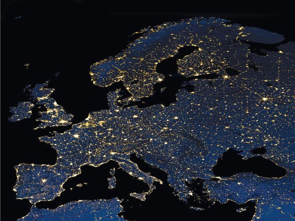
2 Challenges and threats for nation building - just a few of many - Urbanisation/ Megacities Natural Disasters Civil Security Folie 2 Earth Observation Center 2

3 Folie 3 Earth Observation Center 3
4 Motivation Urbanization in the region of Jakarta, Indonesia Folie 4 Earth Observation Center 4


5 TerraSAR-X & TanDEM-X Launched June 15, 2007 & June 21, 2010 Folie 5 Earth Observation Center 5

6 Folie 7 Earth Observation Center 7
7 Global Urban Footprint Technique Calculation of normalized texture image TerraSAR-X intensity, Derived stripmap Detected texture mode built-up image (3m) areas Folie 8 Earth Observation Center 8
 areas Folie 8 Earth Observation")
8 Global Urban Footprint Built-up area Mapping of urban areas from TerraSAR-X stripmap data (3m), Nairobi, Kenya Folie 9 Earth Observation Center 9

9 Global Urban Footprint 2011 / 2012 TanDEM-X mission: - two radar satellites (TSX, TDX) - global digital elevation model - image data: ~3 m - two global coverages (2011, 2012) - DEM standard products: ~ 12 m - acquisition started in 01/2011 => GUF product in 2014 Folie 10 Earth Observation Center 10

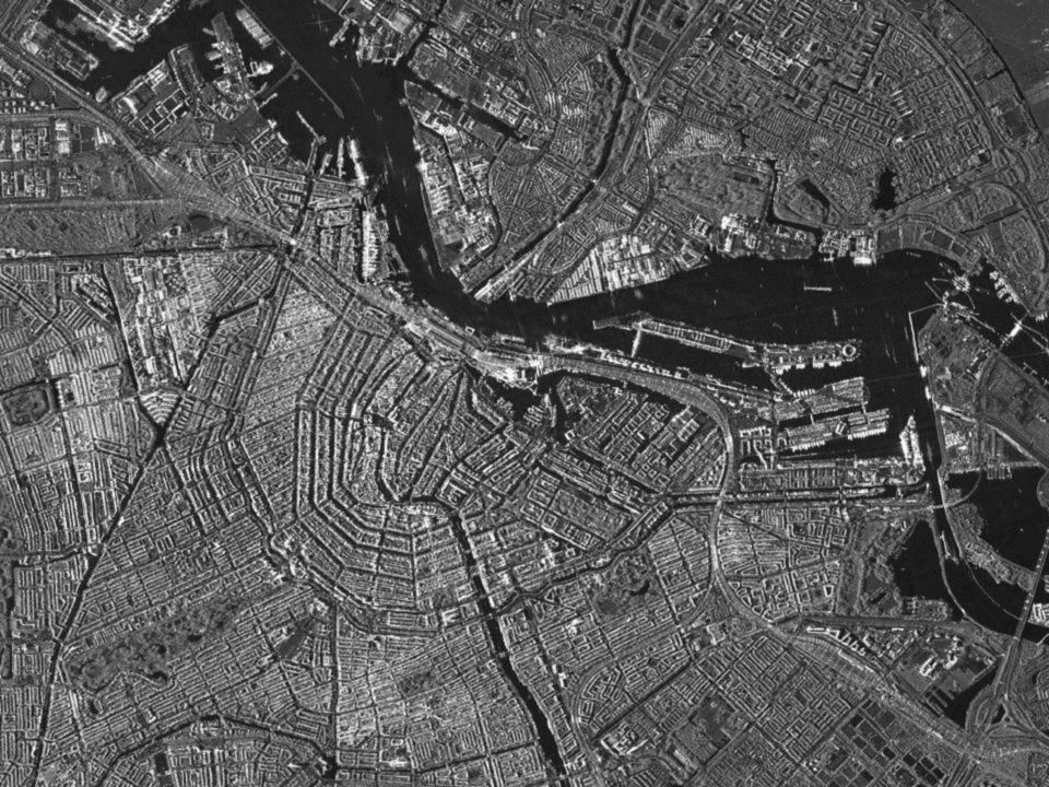
10 WorldView-2 Amsterdam (c) DigitalGlobe, provided by European Space Imaging Folie 11 Earth Observation Center 11

11 Munich urban classification 3D DLR Folie 12 Earth Observation Center 12

12 Folie 13 Earth Observation Center 13

13 Folie 14 Earth Observation Center 14

14 Folie 15 Earth Observation Center 15

15 Folie 16 Earth Observation Center 16
16 Folie 17 Earth Observation Center 17
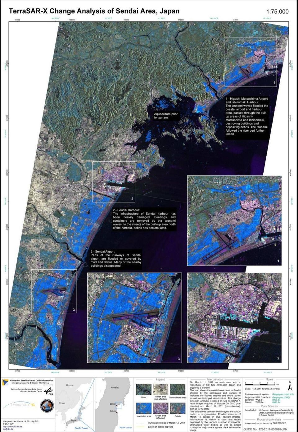
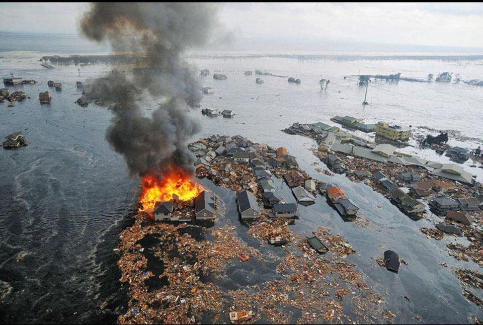
17 Disaster Extent Map - Pre- and Post Disaster Pre-disaster RapidEye Image September 05, 2010 Post-disaster RapidEye Image March 12, 2011 Inundation area derived from TerraSAR-X imagery acquired on March 12, 2011 Folie 19 Earth Observation Center 19

18 Tsunami Inundation Assessment Folie 20 Earth Observation Center 20

19 DLR-Center for Satellite Based Crisis Information (ZKI) Folie 21 Earth Observation Center 21


20 The German Indonesian Tsunami Early Warning System SeisComP3 CGPS Sensor Systems Tide Gauges OBU / PACT GPS-Bouys Sensor System Integration Simulation System Situation Assessment and Decision Support Risk- & Vulnerability Modelling BMKG 5in1 Dissemination System Geospatial Data Repository Folie 23 Earth Observation Center 23

21 Folie 25 Earth Observation Center 25
22 WV2 acquisition of the Costa Concordia. (19 Jan 2012) (c) DigitalGlobe, provided by European Space Imaging Page 27 Folie 27 Earth Observation Center 27
23 SAR-based ship detection vs. AIS (NRT Processing) Golar Arctic (279m) TerraSAR-X coastal AIS Folie 28 Earth Observation Center 28
24 Detected Ships Yellow dots 40 ships were located using the TerraSAR-X radar data Page 29 Folie 29 Earth Observation Center 29
25 TerraSAR-X WorldView-1 ship ship classification detection & identification oil spill Page 30 Folie 30 Earth Observation Center 30
26 DLR Contribution to Ship Detection Navy ship? Merchant ships Gulf of Aden, 5 Dec 2010 TerraSAR-X StripMap TerraSAR-X, InfoTerra/DLR Folie 31 Earth Observation Center 31
27 Die LAND GMES Dienste ATMOSPHERE DISASTERS RAPID MAPPING CLIMATE CHANGE OCEANS CIVIL SECURITY Folie 34 Earth Observation Center 34
28 Gunter Schreier Business Development & GMES DLR German Aerospace Center EOC Earth Observation Center DFD German Remote Sensing Data Center Oberpfaffenhofen D Wessling Germany DLR station at ISSF in Inuvik Photo provided by CCRS Folie 35 Earth Observation Center 35
29 SPARE Folie 36 Earth Observation Center 36
Best Practice: GMES Activities at DLR
 Best Practice: GMES Activities at DLR German Aerospace Center, DLR, Earth Observation Center, EOC German Remote Sensing Data Center, DFD Gunter Schreier Deputy Director Prague, CZ, May 29th, 2012 Folie
German Antarctic Receiving Station GARS O Higgins: Remote sensing as core for a broader range of activities
 DLR.de Chart 1 > Kathrin Hoeppner > EU-Chile-Workshop > November 28-29, 2013 > Punta Arenas, Chile German Antarctic Receiving Station GARS O Higgins: Remote sensing as core for a broader range of activities
Current Status and Considerations for the Future. Harald Mehl & Stefan Voigt German Aerospace Center (DLR)
") Current Status and Considerations for the Future Harald Mehl & Stefan Voigt German Aerospace Center (DLR) Supporting DLR s engagement in EO for civil security Contribution to the implementation of the
Current Status and Considerations for the Future Harald Mehl & Stefan Voigt German Aerospace Center (DLR) Supporting DLR s engagement in EO for civil security Contribution to the implementation of the
Das Copernicus Collaborative GroundSegment des DLR
 Das Copernicus Collaborative GroundSegment des DLR Gunter Schreier Deutsches Fernerkundungsdatenzentrum DFD Earth Observation Center EOC DLR November 2015 Earth Observation Center DLR German Aerospace
The DLR Multi Mission EO Ground Segment
 The DLR Multi Mission EO Ground Segment Payload Ground Segment Erhard Diedrich Remote Sensing Workshop Mexico 22-24 April 2008 DLR Ground Segment for Earth Observation: Servicing GMES, national and commercial
Remote Sensing Applications in Support of Sustainable Development and Disaster Management by DLR Current Activities
 Remote Sensing Applications in Support of Sustainable Development and Disaster Management by DLR Current Activities Dr. Günter Strunz German Aerospace Center (DLR) German Remote Sensing Data Center 43rd
New Space Capabilities for Maritime Surveillance
 www.dlr.de ESA Blue Growth Marititime College, Cork, Ireland 17.4..2013 New Space Capabilities for Maritime Surveillance Susanne Lehner German Aerospace Center DLR Remote Sensing Technology Institute DLR
SAR Measurements of Wind Field, Sea State Topography at Offshore Platforms
 SAR Measurements of Wind Field, Sea State Topography at Offshore Platforms Susanne Lehner DLR, Oberpfaffenhofen Susanne.Lehner@dlr.de Planned NRT Products ENVISAT Wind Sea State OIl Land-Water Line Ships
ROSA ESA - DLR Course 2009 RADAR REMOTE SENSING Day 4-5
 ROSA ESA - DLR Course 2009 RADAR REMOTE SENSING Day 4-5 Dr. Jan-Peter Mund, André Twele & Sandro Martinis German Remote Sensing Data Center (DFD) German Aerospace Center (DLR) RADAR REMOTE SENSING Introduction
The DLR Satellite Station in Inuvik a Milestone for the Canadian-German Cooperation in Earth Observation
 The DLR Satellite Station in Inuvik a Milestone for the Canadian-German Cooperation in Earth Observation Erhard Diedrich German Remote Sensing Data Center DFD EOC German Aerospace Center DLR May 2016 DLR
Real Time Services for Space Applications Holger Maass, Susanne Lehner
 Real Time Services for Space Applications Holger Maass, Susanne Lehner Holger.Maass@dlr.de German Remote Sensing Data Center ( DFD ) with 2 locations in Germany Neustrelitz in Mecklenburg-Vorpommern Oberpfaffenhofen
Comparison of ALOS-PALSAR and TerraSAR-X Data in terms of Detecting Settlements First Results
 ALOS 2008 Symposium, 3-7 November Rhodes, Greece Comparison of ALOS-PALSAR and TerraSAR-X Data in terms of Detecting Settlements First Results Thomas Esch*, Achim Roth*, Michael Thiel, Michael Schmidt*,
June 2011. TerraSAR-X-based Flood Mapping Service
 June 2011 TerraSAR-X-based Flood Mapping Service Service TerraSAR-X-based Flood Mapping Product Flood extent map Product specifications Flood mask / water mask Input / output data Summary Content Date
GPS Precise Point Positioning as a Method to Evaluate Global TanDEM-X Digital Elevation Model
 GPS Precise Point Positioning as a Method to Evaluate Global TanDEM-X Digital Elevation Model 7 th FIG Regional Conference TS 1C Advances in GNSS Positioning and Applications I Volker Schwieger 1, Jürgen
DLR contribution to the UNECE Conference
 DLR contribution to the UNECE Conference Water Unites Strengthening Regional Cooperation on Water Management in Central Asia, Almaty 17-18.11.08 Environmental Monitoring, Information Management, Decision
How To Write A Call To Action For Terrasar-X
 Doc.: TX-PGS-PL-4127 TerraSAR-X Announcement of Opportunity: Utilization of the TerraSAR-X Archive 1 Page: 2 of 11 TABLE OF CONTENTS TERRASAR-X... 1 ANNOUNCEMENT OF OPPORTUNITY: UTILIZATION OF THE TERRASAR-X
Prediction of Storm Surge using Space Data. Susanne Lehner German Aerospace Center
 Prediction of Storm Surge using Space Data Susanne Lehner German Aerospace Center Existing Crisis Information State of the Art of Satellite Crisis Information (ZKI) Mapping after the storm www.zki.de
Thematic Area Water. WP3 - Risk assessment and early warning systems. Task 002 - Remote sensing applications for flood risk management
 Thematic Area Water WP3 - Risk assessment and early warning systems Task 002 - Remote sensing applications for flood risk management German Aerospace Center (DLR) Matthias Mück / Joachim Post Remote Sensing
Combining automated satellite based flood mapping with exposure mapping for flood risk assessment and management
 DLR.de Chart 1 > United Nations/Germany Expert Meeting > A. Twele and F. Hummel > 05 06 2014 Combining automated satellite based flood mapping with exposure mapping for flood risk assessment and management
Deutsches Fernerkundungsdatenzentrum Nationales Bodensegment Neustrelitz. Holger Maass. Storagetechnology 2008 4.-6. Juni 2008, Fleesensee
 Deutsches Fernerkundungsdatenzentrum Nationales Bodensegment Neustrelitz Holger Maass Storagetechnology 2008 4.-6. Juni 2008, Fleesensee German Remote Sensing Data Center ( DFD ) with 2 locations in Germany
Infoterra TanDEM-X Science Meeting Commercial Exploitation
 Infoterra TanDEM-X Science Meeting Commercial Exploitation Bernd Scheuchl & Jürgen Janoth 24.11.2008 Contents Introduction of Infoterra Commercial Exploitation Strategy Final DEM Customized HRTI-4 DEMs
Floods management in Europe : Results of the EC-Project PREVIEW. 2nd UN-SPIDER Workshop Bonn, October 14, 2008 Franz Jaskolla Infoterra GmbH
 Floods management in Europe : Results of the EC-Project PREVIEW 2nd UN-SPIDER Workshop Bonn, October 14, 2008 Franz Jaskolla Infoterra GmbH The Infoterra Group 100% subsidiary of Astrium European Group
The use of Satellite Remote Sensing for Offshore Environmental Benchmarking
 The use of Satellite Remote Sensing for Offshore Environmental Benchmarking Michael King Fugro NPA Limited Fugro NPA (Formerly Nigel Press Associates) World leading Satellite Remote Sensing & Geoscience
Data and Information Management for EO Data Centers. Eberhard Mikusch German Aerospace Center - German Remote Sensing Data Center
 Data and Information Management for EO Data Centers Eberhard Mikusch German Aerospace Center - Mexico, 23. 04 2008 Earth Observation System Environment at DLR/DFD 10010 00101 Radar 10010 00101 Atmospheric
TerraSAR X and TanDEM X satellite missions update & other activities Dana Floricioiu German Aerospace Center (DLR), Remote Sensing Technology
, Remote Sensing Technology") TerraSAR X and TanDEM X satellite missions update & other activities Dana Floricioiu German Aerospace Center (DLR), Remote Sensing Technology Institute, Oberpfaffenhofen, Germany PSTG 2 12 14 June 2012
TerraSAR X and TanDEM X satellite missions update & other activities Dana Floricioiu German Aerospace Center (DLR), Remote Sensing Technology Institute, Oberpfaffenhofen, Germany PSTG 2 12 14 June 2012
Fundamentals of Earth Observation Policy: Examples for German and European Missions. Abstract
 International Symposium on Space Policy and Coordination Framework Technical Session 1 Organized during Map Middle East 2010. 23rd March 2010, Abu Dhabi Fundamentals of Earth Observation Policy: Examples
Enhancing global Cooperation in satellite based Emergency Mapping
 Enhancing global Cooperation in satellite based Emergency Mapping Dr. Stefan Voigt German Aerospace Center - DLR Center for Satellite based Crisis Information - ZKI DLR Background DLR strongly engages
Satellites for Terrain Motion Mapping Terrafirma User Workshop Mining. Nico Adam
 Satellites for Terrain Motion Mapping Terrafirma User Workshop Mining Nico Adam Outline SAR / InSAR observation characteristic Sensors TSX, TDX ERS-1, ERS-2 Processing techniques D-InSAR PSI SBAS Acquisition
Big Data Analytics for Detailed Urban Mapping. Mihai Datcu Daniela Molina Espinoza, Octavian Dumitru, Gottfried Schwarz
 Big Data Analytics for Detailed Urban Mapping Mihai Datcu Daniela Molina Espinoza, Octavian Dumitru, Gottfried Schwarz Big Data: The German EO Digital Library The data access Folie 2 Information vs. Data
The Future of Geospatial Big Data Giovanni Marchisio, Ph.D., Director Product Development
 The Future of Geospatial Big Data Giovanni Marchisio, Ph.D., Director Product Development Nuclear Power Plant, Doel, Belgium December 10, 2011 WorldView-2 Why Geospatial Big Data? We Are the Innovators
TerraSAR-X Applications Guide
 TerraSAR-X Applications Guide Extract: Maritime Monitoring: Oil Spill Detection April 2015 Airbus Defence and Space Geo-Intelligence Programme Line Maritime Monitoring: Oil Spill Detection Issue As the
U.S. COMMERCIAL REMOTE SENSING POLICY. April 25, 2003 FACT SHEET
 U.S. COMMERCIAL REMOTE SENSING POLICY April 25, 2003 FACT SHEET The President authorized a new national policy on April 25, 2003 that establishes guidance and implementation actions for commercial remote
Emergency Management Service. early warning FLOOD AND FIRE ALERTS. Space
 Emergency Management Service early warning FLOOD AND FIRE ALERTS Space 1 Copernicus at a Glance Copernicus is the European Union s Earth Observation programme: a user-driven space programme under civil
The needs on big data management for Operational Geo-Info Services: Emergency Response, Maritime surveillance, Agriculture Management
 Copernicus Big-Data Workshop 2014, 13/14 March The needs on big data management for Operational Geo-Info Services: Emergency Response, Maritime surveillance, Agriculture Management Marco Corsi e-geos 1
ICSU/WMO World Data Center for Remote Sensing of the Atmosphere (WDC RSAT)
") ICSU/WMO World Data Center for Remote Sensing of the Atmosphere (WDC RSAT) Beate Hildenbrand (et al.) German Aerospace Center (DLR) GAW 2009, Geneva, 05 07 May 2009 http://wdc.dlr.de WDC RSAT overview
ICSU/WMO World Data Center for Remote Sensing of the Atmosphere (WDC RSAT) Beate Hildenbrand (et al.) German Aerospace Center (DLR) GAW 2009, Geneva, 05 07 May 2009 http://wdc.dlr.de WDC RSAT overview
Update on Capacity Building Activities at DLR s Earth Observation Center EOC. WGCapD-3 Annual Meeting, Dehradun, India
 www.dlr.de Chart 1 WGCapD-3 Annual Meeting Dehradun/India Dieter Hausamann EO School Lab Update on Capacity Building Activities at DLR s Earth Observation Center EOC WGCapD-3 Annual Meeting, Dehradun,
The European Space Agency s Synthetic Aperture Radar Programme From Experiment to Service Provision
 The European Space Agency s Synthetic Aperture Radar Programme From Experiment to Service Provision Evert Attema ESA, Directorate of Earth Observation Programme! The idea of an independent European space
VULNERABILITY ASSESSMENT FOR THE MEGACITY ISTANBUL WITH REMOTE SENSING
 VULNERABILITY ASSESSMENT FOR THE MEGACITY ISTANBUL WITH REMOTE SENSING Hannes Taubenböck*, Semiha Caliskan, Achim Roth* *DLR, (DFD) Technical University Munich Contents 1. Introduction and Project overview
Committee on the Peaceful Uses of Outer Space Fifty-eighth session
 10 June 2015 English only Committee on the Peaceful Uses of Outer Space Fifty-eighth session Vienna, 10-19 June 2015 The United Nations/Germany International Conference on Earth Observation Global Solutions
GITEWS The German-Indonesian Tsunami Early-Warning System
 GITEWS The German-Indonesian Tsunami Early-Warning System GITEWS-Partner National Helmholtz-Gemeinschaft deutscher Forschungszentren (HGF) GeoForschungsZentrum Potsdam (GFZ) Deutsches Zentrum für Luft-
Big Data Challenge: Mining Heterogeneous Data. Prof. Mihai Datcu. German Aerospace Center (DLR) Munich Aerospace Faculty
 Munich Aerospace Faculty") Big Data Challenge: Mining Heterogeneous Data Prof. Mihai Datcu German Aerospace Center (DLR) Munich Aerospace Faculty Sensing & Big Data Big Data: - Computer hardware and the Cloud - Storage Challenges
Big Data Challenge: Mining Heterogeneous Data Prof. Mihai Datcu German Aerospace Center (DLR) Munich Aerospace Faculty Sensing & Big Data Big Data: - Computer hardware and the Cloud - Storage Challenges
TopoBathy Database Mozambique
 TopoBathy Database Mozambique Andrew Hoggarth, (Canada), Gordon Johnston (UK) Charles de Jongh and peter Schwarzberg (Netherlands) Montevideo Uruguay, 28 th November 2012 Fredericton Canada Heeswijk The
Istanbul Technical University-Center for Satellite Communications and Remote Sensing (ITU-CSCRS)
") Istanbul Technical University-Center for Satellite Communications and Remote Sensing (ITU-CSCRS) Istanbul Technical University, Center for Satellite Communications and Remote Sensing (ITU-CSCRS) was originally
Istanbul Technical University-Center for Satellite Communications and Remote Sensing (ITU-CSCRS) Istanbul Technical University, Center for Satellite Communications and Remote Sensing (ITU-CSCRS) was originally
HIU Common Operating Picture: Health, IDP Locations, USG Assistance
 GIS Support for the Indian Ocean Tsunami Disaster Lee Schwartz Office of the Geographer and Global Issues Bureau of Intelligence and Research U.S. Department of State ESRI Federal Users Conference Washington,
Spectral Response for DigitalGlobe Earth Imaging Instruments
 Spectral Response for DigitalGlobe Earth Imaging Instruments IKONOS The IKONOS satellite carries a high resolution panchromatic band covering most of the silicon response and four lower resolution spectral
JRC and GMES GIO-EMS
 Joint Research Centre JRC and GMES GIO-EMS Guido Lemoine, Jan Kucera, Marco Broglia JRC, Ispra 1st GMES NATIONAL USER FORUM DAY Prague, 29-30 May 2012 Serving society Stimulating innovation Supporting
2015 Global Risk Assessment. Sahar Safaie Program Officer, UNISDR Risk Knowledge Section
 2015 Global Risk Assessment Sahar Safaie Program Officer, UNISDR Risk Knowledge Section Outline Global Assessment Report (GAR) evolution Global Risk Assessment for GAR15 Objective Scope Audience/Users
Monitoring a Changing Environment with Synthetic Aperture Radar. Alaska Satellite Facility National Park Service Don Atwood
 Monitoring a Changing Environment with Synthetic Aperture Radar Don Atwood Alaska Satellite Facility 1 Entering the SAR Age 2 SAR Satellites RADARSAT-1 Launched 1995 by CSA 5.6 cm (C-Band) HH Polarization
Antenna Chetumal: Use of remote sensing data for environmental and civil security applications in Mexico. 22 nd to 24 th of April, 2008
 Antenna Chetumal: Use of remote sensing data for environmental and civil security applications in Mexico 22 nd to 24 th of April, 2008 Location: International Conference Center (ICC). Ciudad de México
College of Engineering Fall 2014 Enrollment Report
 College of Engineering Fall 2014 Enrollment Report UNDERGRADUATE Engineering FE FE 7033 Chemical Engineering 133 49 182 8 0 8 190 7040 General Engineering 21 9 30 0 0 0 30 7041 Electrical Engineering 138
LANDSAT 7 - GROUND SEGMENT ACTIVITIES AT THE GERMAN REMOTE SENSING DATA CENTER. Deutsches Fernerkundungsdatenzentrum (DFD) DLR (*)
 DLR (*)") LANDSAT 7 - GROUND SEGMENT ACTIVITIES AT THE GERMAN REMOTE SENSING DATA CENTER Günter Strunz (*), Hans-Dietrich Bettac (**), Jörg Gredel (*), Klaus-Dieter Reiniger (*) & Gunter Schreier (*) Deutsches Fernerkundungsdatenzentrum
LANDSAT 7 - GROUND SEGMENT ACTIVITIES AT THE GERMAN REMOTE SENSING DATA CENTER Günter Strunz (*), Hans-Dietrich Bettac (**), Jörg Gredel (*), Klaus-Dieter Reiniger (*) & Gunter Schreier (*) Deutsches Fernerkundungsdatenzentrum
PETROBRAS Orbital Sea Surface Monitoring
 PETROBRAS Orbital Sea Surface Monitoring Performed by : Contingency Control - Exploration & Production Area Technical support: R&D Center Cristina Bentz PETROBRAS R&D Center Environment Assessment and
Reporting in a Payload Data Ground Segment ABSTRACT
 Reporting in a Payload Data Ground Segment Martin Güttler, Vlad Manilici, Katrin Molch, Stephan Kiemle German Aerospace Center (DLR) Oberpfaffenhofen, 82234 Wessling, Germany EMail: {Martin.Guettler, Vlad.Manilici,
ABSTRACT INTRODUCTION PURPOSE
 EVALUATION OF TSUNAMI DISASTER BY THE 2011 OFF THE PACIFIC COAST OF TOHOKU EARTHQUAKE IN JAPAN BY USING TIME SERIES SATELLITE IMAGES WITH MULTI RESOLUTION Hideki Hashiba Associate Professor Department
GIT Geology and Information Technology
 Luca Fallati Università degli Studi di Milano-Bicocca: MaRHE Marine Research and High Educational Centre Land Use Changes (LUC) in developing countries are: - faster and widespread; - often not surveyed
Implementing Marine SDI Through Capacity Building
 Implementing Marine SDI Through Capacity Building A TopoBathy Database for Mozambique NIOHC Colombo, 20 th 23 rd March 2012 Fredericton Canada Heeswijk The Netherlands Washington DC United States Adelaide
Maritime Domain Awareness: Mapping, Tracking, and Visualization
 Maritime Domain Awareness: Mapping, Tracking, and Visualization Authorized Distributor for: COM DEV USA and exactearth Ltd Proprietary What is Maritime Domain Awareness? Maritime Domain: All areas and
GLOBAL MONITORING FOR FOOD SECURITY IM SUDAN
 GLOBAL MONITORING FOR FOOD SECURITY IM SUDAN GMFS 3 Carsten Haub & Klaus-Ulrich Komp 18.11.2010 www.eftas.com 1 World hunger World Summit on Food Security FAO, Rome 11.2009 Mehr als 1 Milliarde Mensche
DISASTER DISASTER MANAGEMENT CRISIS INFORMATICS GIS IN DIFFEERENT STAGES OF DISASTER MANAGEMENT
 APPLICATION OF GIS AND REMOTE SENSING IN DISASTER PRONE AREAS: A CASE STUDY IN COASTAL KERALA DISASTER Disaster is an unpleasant event than occurs with little or no warning which results in economic disruption,
DIRECTIONS IN DEVELOPMENT Environment and Sustainable Development. Building Urban Resilience. Principles, Tools, and Practice
 DIRECTIONS IN DEVELOPMENT Environment and Sustainable Development Building Urban Resilience Principles, Tools, and Practice Abhas K. Jha,Todd W. Miner, and Zuzana Stanton-Geddes, Editors Australian THE
Creating a More Resilient Future. Friday 30 May, 11:00 to 12:30, Rooms S29-31
 Creating a More Resilient Future Friday 30 May, 11:00 to 12:30, Rooms S29-31 Empowering Resilience With GIS ICLEI Smart Resilient Cities Strategic Use of Spatial Systems Jim Geringer, Esri Former Governor,
CLASSIFICATION ACCURACY INCREASE USING MULTISENSOR DATA FUSION
 CLASSIFICATION ACCURACY INCREASE USING MULTISENSOR DATA FUSION Aliaksei Makarau, Gintautas Palubinskas, and Peter Reinartz German Aerospace Center (DLR) German Remote Sensing Data Center (DFD) bzw. Remote
Comprehensive Risk Assessment for Urban and National Resilience
 1 Comprehensive Risk Assessment for Urban and National Resilience KFW International Symposium, Frankfurt, Germany 13 November Elizabeth Longworth, Director United Nations Office for Disaster Risk Reduction
Recent Advances in Pixel Localization Accuracy
 Recent Advances in Pixel Localization Accuracy U. Balss, X. Cong, M. Eineder, H. Breit, T. Fritz, B. Schättler Remote Sensing Technology Institute (IMF) German Aerospace Center (DLR) Outline Operational
Japan Meteorological Business Support Center (JMBSC)
") Japan Meteorological Business Support Center (JMBSC) The Japan Meteorological Business Support Center (JMBSC) is a general incorporated foundation* inaugurated in 1994, in accordance with the Meteorological
Japan Meteorological Business Support Center (JMBSC) The Japan Meteorological Business Support Center (JMBSC) is a general incorporated foundation* inaugurated in 1994, in accordance with the Meteorological
The Application of Synthetic Aperture Radar (SAR) to Natural Resource Damage Assessment
 to Natural Resource Damage Assessment") The Application of Synthetic Aperture Radar (SAR) to Natural Resource Damage Assessment George Graettinger NOAA s Ocean Service, Office of Response & Restoration Oil Observing Tools Training & Workshop
The Application of Synthetic Aperture Radar (SAR) to Natural Resource Damage Assessment George Graettinger NOAA s Ocean Service, Office of Response & Restoration Oil Observing Tools Training & Workshop
Update on EUMETSAT ocean colour services. Ewa J. Kwiatkowska
 Update on EUMETSAT ocean colour services Ewa J. Kwiatkowska 1 st International Ocean Colour Science meeting, 6 8 May, 2013 EUMETSAT space data provider for operational oceanography Operational data provider
Critical Asset Protection Oil and Gas Protection
 Critical Asset Protection Oil and Gas Protection Our Oil & Gas Protection project in the Middle-East features Wisdom Command and Control (C2) system that uses unique correlation algorithms to integrate
'Developments and benefits of hydrographic surveying using multispectral imagery in the coastal zone
 Abstract With the recent launch of enhanced high-resolution commercial satellites, available imagery has improved from four-bands to eight-band multispectral. Simultaneously developments in remote sensing
DIGITAL ELEVATION MODEL DATABASE W42 - A SCALABLE SYSTEM FOR SPATIAL DATA
 DIGITAL ELEVATION MODEL DATABASE W42 - A SCALABLE SYSTEM FOR SPATIAL DATA M. Habermeyer, U. Marschalk, A. Roth German Aerospace Center (DLR),German Remote Sensing Data Center (DFD) 82234 Wessling, Germany,(martin.habermeyer,ursula.marschalk,achim.roth)@dlr.de
Capturing building inventory data for earthquake risk assessment: The GEM perspective. Risk Global Component Inventory Data Capture Tools
 Risk Global Component Inventory Data Capture Tools Capturing building inventory data for earthquake risk assessment: The GEM perspective NCEO/CEOI Joint Science Conference, Nottingham 2/9/212 John Bevington,
A tiered reconnaissance approach toward flood monitoring utilising multi-source radar and optical data
 5 th International Workshop on Remote Sensing for Disaster Response A tiered reconnaissance approach toward flood monitoring utilising multi-source radar and optical data Anneley McMillan Dr. Beverley
II. Related Activities
 (1) Global Cloud Resolving Model Simulations toward Numerical Weather Forecasting in the Tropics (FY2005-2010) (2) Scale Interaction and Large-Scale Variation of the Ocean Circulation (FY2006-2011) (3)
ESA Earth Observation and the need for high speed networking
 ESA Earth Observation and the need for high speed networking Pisa, 11 th May 25 11 th May 25 GARR Conference 5 1 ESA Earth Observation 11 th May 25 GARR Conference 5 2 The European Space Agency The European
Space Cloud: From a Distributed On-board Computer to a Federated System-of Systems in Space Daniel Lüdtke, Volker Schaus, Andreas Gerndt
 DLR.de Chart 1 Space Cloud: From a Distributed On-board Computer to a Federated System-of Systems in Space Daniel Lüdtke, Volker Schaus, Andreas Gerndt German Aerospace Center (DLR) Simulation and Software
Application of Space Technology for Disaster monitoring and assessment current state in Vietnam
 Application of Space Technology for Disaster monitoring and assessment current state in Vietnam Lai Anh Khoi SPACE TECHNOLOGY INSTITUTE 8th GEOSS Asian Pacific Symposium Beijing, Sep. 09-11, 2015 Types
Global Earth Observation Integrated Data Environment (GEO-IDE) Presentation to the Data Archiving and Access Requirements Working Group (DAARWG)
 Presentation to the Data Archiving and Access Requirements Working Group (DAARWG)") Global Earth Observation Integrated Data Environment (GEO-IDE) Presentation to the Data Archiving and Access Requirements Working Group (DAARWG) Ken McDonald Data Management Integration Architect National
Global Earth Observation Integrated Data Environment (GEO-IDE) Presentation to the Data Archiving and Access Requirements Working Group (DAARWG) Ken McDonald Data Management Integration Architect National
TAMU-CC UAS Program 1
 TAMU-CC UAS Program 1 TAMU-CC Major Research Initiatives Coastal & Marine Economic & environmental sustainability Ecosystem evaluation Shoreline mapping Water supply studies Policy Engineering Science
Role of GIS for Flood Risk Assessment in Muzaffarabad City, Kashmir, Pakistan
 Role of GIS for Flood Risk Assessment in Muzaffarabad City, Kashmir, Pakistan Mr. Falak Nawaz, Research Associate Dr. Syed Hamidullah, Professor & Director National Centre of Excellence in Geology, University
WATERLINE DETECTION AND MONITORING IN THE GERMAN WADDEN SEA USING HIGH RESOLUTION SATELLITE-BASED RADAR MEASUREMENTS
 WATERLINE DETECTION AND MONITORING IN THE GERMAN WADDEN SEA USING HIGH RESOLUTION SATELLITE-BASED RADAR MEASUREMENTS S. Wiehlea,, S. Lehnera, A. Pleskachevskya a DLR, Maritime Security Lab, 28201 Bremen,
Technology Trends In Geoinformation
 Technology Trends In Geoinformation Dato Prof. Sr Dr. Abdul Kadir Bin Taib Department of Survey and Mapping Malaysia (JUPEM) Email: drkadir@jupem.gov.my www.jupem.gov.my NGIS 2008 3 rd. National GIS Conference
HAZARD RISK ASSESSMENT, MONITORING, MAINTENANCE AND MANAGEMENT SYSTEM (HAMMS) FOR LANDSLIDE AND FLOOD. Mohd. Nor Desa, Rohayu and Lariyah, UNITEN
 FOR LANDSLIDE AND FLOOD. Mohd. Nor Desa, Rohayu and Lariyah, UNITEN") HAZARD RISK ASSESSMENT, MONITORING, MAINTENANCE AND MANAGEMENT SYSTEM (HAMMS) FOR LANDSLIDE AND FLOOD Mohd. Nor Desa, Rohayu and Lariyah, UNITEN WHAT WE HAVE IN MIND AND FROM OUR PREVIOUS PROJECT CONTRIBUTION
HAZARD RISK ASSESSMENT, MONITORING, MAINTENANCE AND MANAGEMENT SYSTEM (HAMMS) FOR LANDSLIDE AND FLOOD Mohd. Nor Desa, Rohayu and Lariyah, UNITEN WHAT WE HAVE IN MIND AND FROM OUR PREVIOUS PROJECT CONTRIBUTION
Julie Pullen, CSR Director Stevens Institute of Technology
 The Center for Secure and Resilient Maritime Commerce (CSR) A DHS National Center of Excellence for Maritime Security Research & Education Overview Julie Pullen, CSR Director Stevens Institute of Technology
The RapidEye optical satellite family for high resolution imagery
 'Photogrammetric Week 01' D. Fritsch & R. Spiller, Eds. Wichmann Verlag, Heidelberg 2001. Scherer, Krischke 139 The RapidEye optical satellite family for high resolution imagery STEFAN SCHERER and MANFRED
National Data Buoy Center Cooperative Relations
 National Data Buoy Center Cooperative Relations Presentation For NGI Annual Conference May 23, 2012 Landry Bernard National Data Buoy Center Operational Mission To provide a real-time, end-to-end capability
The following was presented at DMT 14 (June 1-4, 2014, Newark, DE).
.") DMT 2014 The following was presented at DMT 14 (June 1-4, 2014, Newark, DE). The contents are provisional and will be superseded by a paper in the DMT 14 Proceedings. See also presentations and Proceedings
DMT 2014 The following was presented at DMT 14 (June 1-4, 2014, Newark, DE). The contents are provisional and will be superseded by a paper in the DMT 14 Proceedings. See also presentations and Proceedings
Review for Introduction to Remote Sensing: Science Concepts and Technology
 Review for Introduction to Remote Sensing: Science Concepts and Technology Ann Johnson Associate Director ann@baremt.com Funded by National Science Foundation Advanced Technological Education program [DUE
13 th EC GI & GIS Workshop WIN: A new OGC compliant SOA. for risk management. GMV, 2007 Property of GMV All rights reserved
 13 th EC GI & GIS Workshop WIN: A new OGC compliant SOA for risk management GMV, 2007 Property of GMV All rights reserved Content 1. Introduction 2. Objectives 3. Architecture and Model 4. Technical aspects
The European Union Satellite Centre: GEOINT Analysis for the European Union
 UNCLASSIFIED / FOR OFFICIAL USE ONLY European Union Satellite Centre The European Union Satellite Centre: GEOINT Analysis for the European Union The Use of Space in the Framework of CSDP War Museum, Athens,
Sentinel-1 Mission Overview
 Sentinel-1 Mission Overview Pierre Potin Sentinel-1 Mission Manager, ESA Advanced Course on Radar Polarimetry ESRIN, Frascati, 19 January 2011 Global Monitoring for Environment and Security GMES is established
IV WORKSHOP RNP2 (WRNP2)
") IV WORKSHOP RNP2 (WRNP2) Hotel Pirâmide, Natal, RN, 19-20 de Maio de 2003 Advanced Network Engineering and Applications from Space Missions - AUTHORS - Eduardo W. Bergamini Serviços Aplicativos em Missões
IV WORKSHOP RNP2 (WRNP2) Hotel Pirâmide, Natal, RN, 19-20 de Maio de 2003 Advanced Network Engineering and Applications from Space Missions - AUTHORS - Eduardo W. Bergamini Serviços Aplicativos em Missões
Homeland Security Infrastructure Program HSIP Gold 2012 September 2012
 Homeland Security Infrastructure Program HSIP Gold 2012 September 2012 George Thomas, Chief, Content & Knowledge Management Division (PDC) IWG-Readiness, Response & Recovery (IWG-R3) George.J.Thomass@nga.mil,
Probabilistic Risk Assessment Studies in Yemen
 Probabilistic Risk Assessment Studies in Yemen The catastrophic risk analysis quantifies the risks of hazard, exposure, vulnerability, and loss, thus providing the decision maker with the necessary information
Small Satellite Space Traffic Management
 Small Satellite Space Traffic Management Brian Weeden Technical Advisor Secure World Foundation 1 THE SHIFT FROM BIG SATELLITES TO SMALL ONES 2 Historically, satellites were large and complex machines
Remote Sensing: Correlating Satellite Images with In-field Observations for Advanced Damage Detection
 Remote Sensing: Correlating Satellite Images with In-field Observations for Advanced Damage Detection ImageCat, Inc. Shubharoop Ghosh Beverley J. Adams, Ph.D. ImageCat, Inc. J. Arn Womble, P.E. Texas Tech
Microwaves and Radar Institute
 Microwaves and Radar Institute Research and Projects Alberto Moreira German Aerospace Center DLR Oberpfaffenhofen, Germany Microwaves and Radar Institute 30+ years of experience in SAR systems and applications
From Whitehall to orbit and back again: using space in government
 From Whitehall to orbit and back again: using space in government 18 th June 2014 Bristol 25 th June 2014 Liverpool 3 rd July 2014 -Newcastle Space for Smarter Government Programme (ssgp@sa.catapult.org.uk)
Status Report DFD 2007 2013. German Remote Sensing Data Center. Deutsches Fernerkundungsdatenzentrum
 Status Report DFD 2007 2013 German Remote Sensing Data Center Deutsches Fernerkundungsdatenzentrum Status Report 2007 2013 Publisher Deutsches Zentrum für Luft- und Raumfahrt e.v. German Aerospace Center
NOAA COASTAL SERVICES CENTER Strategic Plan: 2010 to 2015
 NOAA COASTAL SERVICES CENTER Strategic Plan: 2010 to 2015 N a t i o n a l O c e a n i c a n d A t m o s p h e r i c A d m i n i s t r a t i o n ( N O A A ) C o a s t a l S e r v i c e s C e n t e r March
Cluster Applied Remote Sensing TerraSAR-X Ground Segment Basic Product Specification Document. Ground Segment. Basic Product Specif ication Document
 Page: 1 of 108 Ground Segment Basic Product Specif ication Document CAF - Cluster Applied Remote Sensing editors: 30.3.2009 T. Fritz, M. Eineder Date SAR ~rbduct Verification Responsible & TMSP Team reviewed: