IRS Level 2 Processing Concept Status
|
|
|
- Merry Matilda Walker
- 9 years ago
- Views:
Transcription
1 IRS Level 2 Processing Concept Status Stephen Tjemkes, Jochen Grandell and Xavier Calbet 6th MTG Mission Team Meeting June 2008, Estec, Noordwijk Page 1

2 Content Introduction Level 2 Processing Concept Description of Modules Proxy data Conclusion Page 2

3 MTG-IRS mission objective Primary mission objective is to monitor small scale water vapour structures in support of regional and global NWP A secondary objective is to support the monitoring of atmospheric dynamics through e.g. the provision of clear sky wind, global instability,.. A further objective is to support emerging applications regarding chemical weather and air quality Page 3

4 Thus primary mission objective calls for accurate moisture and to a lesser degree temperature profiles from MTG-IRS observations. The development of operational L2 processing scheme is presented next. How this will be used for the implementation of an operational scheme is TBD. Page 4

5 L2 Processing Concept Input: radiometrically and spectrally calibrated spectra with geometrical information appended auxilliary data Processing split into Pre-processing to determine the type of scene: clear/cloudy, dusty, fire, cloud parameter determination. Quick processing: retrievals using a fast statistical technique like EOF linear regression, neural networks, etc Processing: Physical retrieval (optimal estimation). Post-processing: formating, gridding, QA, Output Profiles of moisture and temperature + error co-variance Page 5
.")
6 Processing: The Challenge Retrievals can be performed for all scenes (though the quality depends on presence of clouds) Example iasi L2 (processing 235 channels per spectrum): On current system (2CPU IBM power 4 processor): min/spectrum IRS: > spectra / BRC => min to process one BRC Note that this is with respect to IBM power 4 Machines (several years old technology). Current state of the art machines (e.g. Power 6) are significant factors faster. Still we need to explore all possibilities to keep the L2 processing affordable. So we need to look at Implementation: Efficient codes (e.g. different RTM) Parallelisation Processing Not all scenes => need for scenes analysis All should be done without compromising quality. Page 6
 are significant factors faster. Still we need to explore all possibilities to keep the L2 processing affordable.")
7 End-to-End L2 Processing Chain Radiative transfer modeling Scenes Analysis Inversion Page 7

8 RTM Need for an efficient radiative transfer module Scene Inversion PCRTM OSS RTTOV Community? + ++ Maintenance? + Performance?? ++? Accuracy??? Static Application Page 8

9 RTTOV vrs OSS: two different approaches RTTOV: Statistical model for mean transmission Multiple scattering (TBC) Includes Jacobians Difficulties wide band imagers OSS: Course resolution line-by-line Multiple scattering (Not yet procured) Jacobians PC scores could be implemented Page 9
 Jacobians PC scores could be")
10 RTTOV-OSS Comparison 5801 diverse profiles Sea surface emissivity T, q, O3 from ECMWF Rest: climatology RTTOV-9 GENLN2, HITRAN 2000, CKD2.4 OSS LBLRTM V11.3, HITRAN2004, MT_CKD 1.0 LBLRTM V11.3 as reference (for 500 profiles) Page 10

11 Timing Results (in sec/profile) Direct only Direct + Jacobians RTTOV OSS Averaged over 5308 profiles, on IBM power 2: xlf90 O3 q64 Page 11

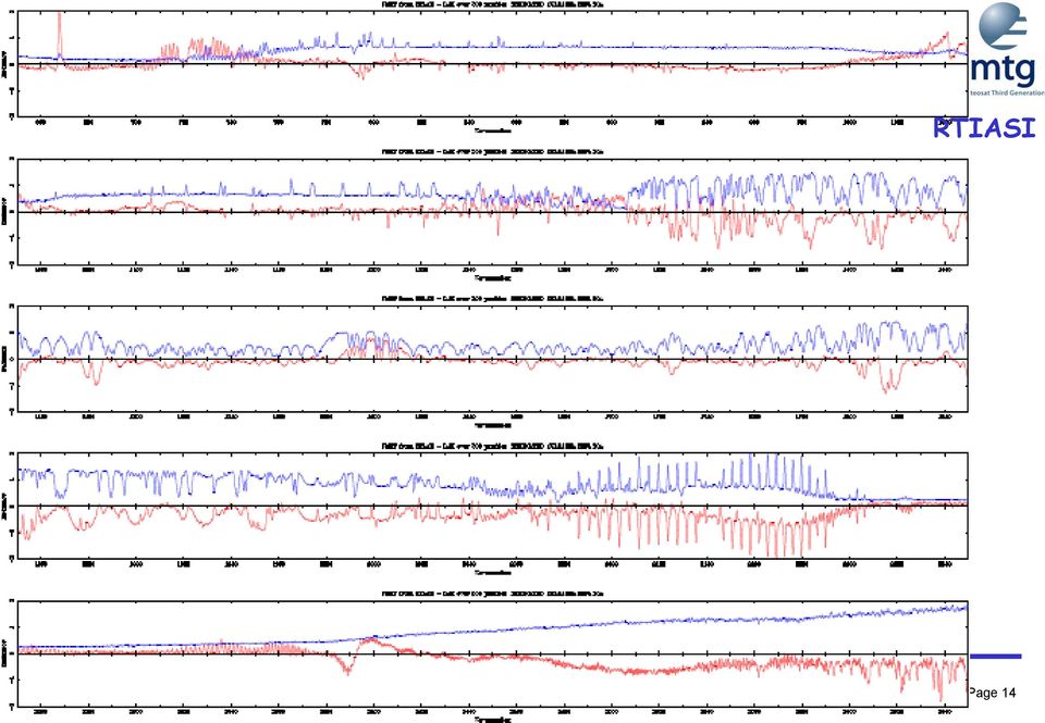
12 Comparison to IASI First OSS Second RTIASI Averaged results over 500 cases Red line mean Blue standard deviation Page 12

13 OSS Page 13

14 RTIASI Page 14
15 Comparison to LBLRTM RTTOV SAD were generated using GENLN2 OSS SAD were generated using LBLRTM Difference in performance could be result of difference in GENLN2 and LBLRTM. Single profile Red line OSS Blue line RTTOV Page 15

16 Page 16

17 Summary For hyperspectral applications: Performance: OSS = RTTOV/16 Accuracy: OSS compares favourable to reference Not shown: For Imager applications: Performance OSS = 2*RTTOV Accuracy: OSS compares favourable to reference We will use OSS for our development of IRS L2 processing Page 17

18 Expert Note: Reduce the number of mono-chromatic calculations by OSS significantly through the so-called global training, as opposed to the localised training applied here (up to factor 10) There is room to improve OSS efficiency, by how much will depend on application (hyperspectral, imagery) Page 18

19 Pre-processing: Scenes Analysis At Day-1 process only cloud free FOV (+ maybe Low Level clouds) Implemented the SCE by Watts & McNally for AIRS/IASI. Page 19

20 Scenes Analysis: Method Page 20

21 Cloudy - clear radiances (provided by phil watts) Page 21
22 Cloudy - clear radiances (provided by phil watts) Small difference Big difference Clear radiances *RTTOV- 6 (Matricardi et al.) *Ecmwf T,Q,O 3 *Model noise (H.B.H T + F) Cloudy radiances *RTTOV-6 + (Chevallier et al.) *Ecmwf T,Q,O 3,CLW *Meas. Noise (O) (AIRS Flight Model) Page 22
23 Pressure ranking: all channels (228 NESDIS NRT) Model noise (in 6 μm band) Measured - Model (K) Cloud emissivity effect Page 23
24 Clear-channel id 1: Low-pass filter δbt(j) LP[δBT(j)] ch Measured - Model (K) Detect gross cloud signal (+ or -) * Proceed > higher until LP gradient & signal small Declare channels with smaller index clear Ranked channel index Page 24
25 Scenes Analysis: results applied to IASI Page 25
26 Page 26
27 Page 27
28 IASI L2 cloud mask Page 28
29 Quantitative Comparson IASI L2 Cloud Mask No data Cloudy Clear ECMWF cloud detection (ECD) No data Cloudy Clear Page 29
30 Conclusion Successfully implemented Not yet an extensive validation Need to apply to MTG-proxy data Integrate into end-to-end development chain Replace current rtm with OSS CO2 slicing alternative methods to be considered Gives cloud top pressure and cloud fraction Page 30
31 CO2 slicing results: cloud fraction Page 31
32 CO2 slicing results: cloud top pressure Page 32
33 CO2 slicing results: cloud top pressure Page 33
34 Inversion Page 34
35 IRS L2 Prototype Processor tests IRS L2 Prototype Processor running with: IASI real data converted to IRS with IASI2IRS tool IRS spectra have the original noise coming from IASI RTM: RTTOV-9.1+IASI2IRS Clear sky over ocean selection scenes as for IASI (threshold test method only) Bias corrected Optimal estimation First guess from EOF retrieval Background from Chevallier Optimal measurement covariance from OBS-CALC Page 35
36 IRS L2 OBS-CALC Bias and STDV Page 36
37 IRS and IASI EOF retrievals Page 37
38 IRS and IASI Physical retrievals Page 38
39 IRS L2 Inversion: future Improve fast retrieval method -> Neural networks? Introduce faster radiative transfer model -> OSS Keep on verifying with real IASI data correct scene classification Introduce realistic noise into IRS synthetic measurements Introduce pseudo-noise diffraction effects into IRS synthetic measurements using proxy data Determine minimal set of channels for with Inversion will be applied Analyse co-registration errors Analyse correlated noise in observations Analyse spectral calibration errors Apply to field experiements (jaivex), proxy data Compare to independent methods Page 39
40 Other components Surface emissivity retrieval Improve accuracy through exploitation of the time domain (e.g. Kalman filter) Page 40
41 Proxy Data For end-to-end processing chain For technical studies like compression, error budgets Source IASI Synthetic based on models run by SSEC Met Office Page 41
42 IASI as proxy for IRS IASI L1C can be converted into IRS Select LWIR or MWIR Generate Interferogram De-apodise interferogram Truncate Interferogram Convert into spectrum Tool to do this is available upon request Can be applied to Observations, simulations and jacobians Page 42
43 IRS proxy data from WRF In support of GOES-R H. Huang, T. Greenwald and xx generated two case studies based upon WRF Consider here the European simulation Hope to get a sample tape soon, to see if we can transfer data using LTO III data-tapes Data needs to be converted into IRS (and possible other candidate mission) radiances August 2006 Domain File Size per Output Time (GB) Total Dataset Size (TB) Spatial Resolution (km) UTC UTC UTC Temporal Resolution (minute) Full disk 103 GB 16 TB WRF model output data volume and spatial and temporal resolution for the NCSA MSG simulation. Page 43
Assimilation of cloudy infrared satellite observations: The Met Office perspective
 Assimilation of cloudy infrared satellite observations: The Met Office perspective Ed Pavelin, Met Office International Symposium on Data Assimilation 2014, Munich Contents This presentation covers the
Towards assimilating IASI satellite observations over cold surfaces - the cloud detection aspect
 Towards assimilating IASI satellite observations over cold surfaces - the cloud detection aspect Tuuli Perttula, FMI + Thanks to: Nadia Fourrié, Lydie Lavanant, Florence Rabier and Vincent Guidard, Météo
An Introduction to the MTG-IRS Mission
 An Introduction to the MTG-IRS Mission Stefano Gigli, EUMETSAT IRS-NWC Workshop, Eumetsat HQ, 25-0713 Summary 1. Products and Performance 2. Design Overview 3. L1 Data Organisation 2 Part 1 1. Products
Clear Sky Radiance (CSR) Product from MTSAT-1R. UESAWA Daisaku* Abstract
 Product from MTSAT-1R. UESAWA Daisaku* Abstract") Clear Sky Radiance (CSR) Product from MTSAT-1R UESAWA Daisaku* Abstract The Meteorological Satellite Center (MSC) has developed a Clear Sky Radiance (CSR) product from MTSAT-1R and has been disseminating
Clear Sky Radiance (CSR) Product from MTSAT-1R UESAWA Daisaku* Abstract The Meteorological Satellite Center (MSC) has developed a Clear Sky Radiance (CSR) product from MTSAT-1R and has been disseminating
Studying cloud properties from space using sounder data: A preparatory study for INSAT-3D
 Studying cloud properties from space using sounder data: A preparatory study for INSAT-3D Munn V. Shukla and P. K. Thapliyal Atmospheric Sciences Division Atmospheric and Oceanic Sciences Group Space Applications
The impact of window size on AMV
 The impact of window size on AMV E. H. Sohn 1 and R. Borde 2 KMA 1 and EUMETSAT 2 Abstract Target size determination is subjective not only for tracking the vector but also AMV results. Smaller target
ECMWF Aerosol and Cloud Detection Software. User Guide. version 1.2 20/01/2015. Reima Eresmaa ECMWF
 ECMWF Aerosol and Cloud User Guide version 1.2 20/01/2015 Reima Eresmaa ECMWF This documentation was developed within the context of the EUMETSAT Satellite Application Facility on Numerical Weather Prediction
Solar Irradiance Forecasting Using Multi-layer Cloud Tracking and Numerical Weather Prediction
 Solar Irradiance Forecasting Using Multi-layer Cloud Tracking and Numerical Weather Prediction Jin Xu, Shinjae Yoo, Dantong Yu, Dong Huang, John Heiser, Paul Kalb Solar Energy Abundant, clean, and secure
Synoptic assessment of AMV errors
 NWP SAF Satellite Application Facility for Numerical Weather Prediction Visiting Scientist mission report Document NWPSAF-MO-VS-038 Version 1.0 4 June 2009 Synoptic assessment of AMV errors Renato Galante
Cloud detection by using cloud cost for AIRS: Part 1
 cloud cost for the Advanced Infrared Radiometer Sounder (Part I) - A simulation study - August 19, 2002 Yoshiaki Takeuchi Japan Meteorological Agency EUMETSAT NWP-SAF Visiting Scientist to Met Office,
Meteorological Forecasting of DNI, clouds and aerosols
 Meteorological Forecasting of DNI, clouds and aerosols DNICast 1st End-User Workshop, Madrid, 2014-05-07 Heiner Körnich (SMHI), Jan Remund (Meteotest), Marion Schroedter-Homscheidt (DLR) Overview What
ENVI Classic Tutorial: Atmospherically Correcting Multispectral Data Using FLAASH 2
 ENVI Classic Tutorial: Atmospherically Correcting Multispectral Data Using FLAASH Atmospherically Correcting Multispectral Data Using FLAASH 2 Files Used in this Tutorial 2 Opening the Raw Landsat Image
VIIRS-CrIS mapping. NWP SAF AAPP VIIRS-CrIS Mapping
 NWP SAF AAPP VIIRS-CrIS Mapping This documentation was developed within the context of the EUMETSAT Satellite Application Facility on Numerical Weather Prediction (NWP SAF), under the Cooperation Agreement
Improved diagnosis of low-level cloud from MSG SEVIRI data for assimilation into Met Office limited area models
 Improved diagnosis of low-level cloud from MSG SEVIRI data for assimilation into Met Office limited area models Peter N. Francis, James A. Hocking & Roger W. Saunders Met Office, Exeter, U.K. Abstract
A system of direct radiation forecasting based on numerical weather predictions, satellite image and machine learning.
 A system of direct radiation forecasting based on numerical weather predictions, satellite image and machine learning. 31st Annual International Symposium on Forecasting Lourdes Ramírez Santigosa Martín
Satellite Remote Sensing of Volcanic Ash
 Marco Fulle www.stromboli.net Satellite Remote Sensing of Volcanic Ash Michael Pavolonis NOAA/NESDIS/STAR SCOPE Nowcasting 1 Meeting November 19 22, 2013 1 Outline Getty Images Volcanic ash satellite remote
16 th IOCCG Committee annual meeting. Plymouth, UK 15 17 February 2011. mission: Present status and near future
 16 th IOCCG Committee annual meeting Plymouth, UK 15 17 February 2011 The Meteor 3M Mt satellite mission: Present status and near future plans MISSION AIMS Satellites of the series METEOR M M are purposed
MSG MPEF Products focus on GII Simon Elliott Meteorological Operations Division [email protected]
 MSG MPEF focus on GII Simon Elliott Meteorological Operations Division [email protected] MSG Application Workshop, 15-19 March 2010, Alanya, Türkiye Slide: 1 1. What is the MPEF? Meteorological
Validation of SEVIRI cloud-top height retrievals from A-Train data
 Validation of SEVIRI cloud-top height retrievals from A-Train data Chu-Yong Chung, Pete N Francis, and Roger Saunders Contents Introduction MO GeoCloud AVAC-S Long-term monitoring Comparison with OCA Summary
Labs in Bologna & Potenza Menzel. Lab 3 Interrogating AIRS Data and Exploring Spectral Properties of Clouds and Moisture
 Labs in Bologna & Potenza Menzel Lab 3 Interrogating AIRS Data and Exploring Spectral Properties of Clouds and Moisture Figure 1: High resolution atmospheric absorption spectrum and comparative blackbody
SAFNWC/MSG Cloud type/height. Application for fog/low cloud situations
 SAFNWC/MSG Cloud type/height. Application for fog/low cloud situations 22 September 2011 Hervé LE GLEAU, Marcel DERRIEN Centre de météorologie Spatiale. Lannion Météo-France 1 Fog or low level clouds?
V6 AIRS Spectral Calibra2on
 V6 AIRS Spectral Calibra2on Evan Manning Bob Deen Yibo Jiang George Aumann Denis EllioA Jet Propulsion Laboratory California Ins2tute of Technology 5/4/09 1 Spectral Calibra2on Primer AIRS measures radiance
Solarstromprognosen für Übertragungsnetzbetreiber
 Solarstromprognosen für Übertragungsnetzbetreiber Elke Lorenz, Jan Kühnert, Annette Hammer, Detlev Heienmann Universität Oldenburg 1 Outline grid integration of photovoltaic power (PV) in Germany overview
Volcanic Ash Monitoring: Product Guide
 Doc.No. Issue : : EUM/TSS/MAN/15/802120 v1a EUMETSAT Eumetsat-Allee 1, D-64295 Darmstadt, Germany Tel: +49 6151 807-7 Fax: +49 6151 807 555 Date : 2 June 2015 http://www.eumetsat.int WBS/DBS : EUMETSAT
Digital image processing
 746A27 Remote Sensing and GIS Lecture 4 Digital image processing Chandan Roy Guest Lecturer Department of Computer and Information Science Linköping University Digital Image Processing Most of the common
Active Fire Monitoring: Product Guide
 Active Fire Monitoring: Product Guide Doc.No. Issue : : EUM/TSS/MAN/15/801989 v1c EUMETSAT Eumetsat-Allee 1, D-64295 Darmstadt, Germany Tel: +49 6151 807-7 Fax: +49 6151 807 555 Date : 14 April 2015 http://www.eumetsat.int
The APOLLO cloud product statistics Web service The APOLLO cloud product statistics Web service
 The APOLLO cloud product statistics Web service Introduction DLR and Transvalor are preparing a new Web service to disseminate the statistics of the APOLLO cloud physical parameters as a further help in
Data Processing Flow Chart
 Legend Start V1 V2 V3 Completed Version 2 Completion date Data Processing Flow Chart Data: Download a) AVHRR: 1981-1999 b) MODIS:2000-2010 c) SPOT : 1998-2002 No Progressing Started Did not start 03/12/12
How To Understand Cloud Properties From Satellite Imagery
 P1.70 NIGHTTIME RETRIEVAL OF CLOUD MICROPHYSICAL PROPERTIES FOR GOES-R Patrick W. Heck * Cooperative Institute for Meteorological Satellite Studies, University of Wisconsin-Madison Madison, Wisconsin P.
Overview of the IR channels and their applications
 Ján Kaňák Slovak Hydrometeorological Institute [email protected] Overview of the IR channels and their applications EUMeTrain, 14 June 2011 Ján Kaňák, SHMÚ 1 Basics in satellite Infrared image interpretation
Environmental Remote Sensing GEOG 2021
 Environmental Remote Sensing GEOG 2021 Lecture 4 Image classification 2 Purpose categorising data data abstraction / simplification data interpretation mapping for land cover mapping use land cover class
CrIS L1B Project Status
 CrIS L1B Project Status Graeme Martin 1, Hank Revercomb 1, Larrabee Strow 2, Dave Tobin 1, Howard Moteller 2, Liam Gumley 1, Ray Garcia 1, Greg Quinn 1, Joe Taylor 1, Coda Phillips 1, Bob Knuteson 1, Jessica
Application of Numerical Weather Prediction Models for Drought Monitoring. Gregor Gregorič Jožef Roškar Environmental Agency of Slovenia
 Application of Numerical Weather Prediction Models for Drought Monitoring Gregor Gregorič Jožef Roškar Environmental Agency of Slovenia Contents 1. Introduction 2. Numerical Weather Prediction Models -
McIDAS-V Tutorial Displaying Polar Satellite Imagery updated September 2015 (software version 1.5)
") McIDAS-V Tutorial Displaying Polar Satellite Imagery updated September 2015 (software version 1.5) McIDAS-V is a free, open source, visualization and data analysis software package that is the next generation
McIDAS-V Tutorial Displaying Polar Satellite Imagery updated September 2015 (software version 1.5) McIDAS-V is a free, open source, visualization and data analysis software package that is the next generation
SYNERGISTIC USE OF IMAGER WINDOW OBSERVATIONS FOR CLOUD- CLEARING OF SOUNDER OBSERVATION FOR INSAT-3D
 SYNERGISTIC USE OF IMAGER WINDOW OBSERVATIONS FOR CLOUD- CLEARING OF SOUNDER OBSERVATION FOR INSAT-3D ABSTRACT: Jyotirmayee Satapathy*, P.K. Thapliyal, M.V. Shukla, C. M. Kishtawal Atmospheric and Oceanic
GOES-R AWG Cloud Team: ABI Cloud Height
 GOES-R AWG Cloud Team: ABI Cloud Height June 8, 2010 Presented By: Andrew Heidinger 1 1 NOAA/NESDIS/STAR 1 Outline Executive Summary Algorithm Description ADEB and IV&V Response Summary Requirements Specification
Data Processing Developments at DFD/DLR. Stefanie Holzwarth Martin Bachmann, Rudolf Richter, Martin Habermeyer, Derek Rogge
 Data Processing Developments at DFD/DLR Stefanie Holzwarth Martin Bachmann, Rudolf Richter, Martin Habermeyer, Derek Rogge EUFAR Joint Expert Working Group Meeting Edinburgh, April 14th 2011 Conclusions
LANDSAT 8 Level 1 Product Performance
 Réf: IDEAS-TN-10-QualityReport LANDSAT 8 Level 1 Product Performance Quality Report Month/Year: January 2016 Date: 26/01/2016 Issue/Rev:1/9 1. Scope of this document On May 30, 2013, data from the Landsat
Partnership to Improve Solar Power Forecasting
 Partnership to Improve Solar Power Forecasting Venue: EUPVSEC, Paris France Presenter: Dr. Manajit Sengupta Date: October 1 st 2013 NREL is a national laboratory of the U.S. Department of Energy, Office
All-sky assimilation of microwave imager observations sensitive to water vapour, cloud and rain
 All-sky assimilation of microwave imager observations sensitive to water vapour, cloud and rain A.J. Geer, P. Bauer, P. Lopez and D. Salmond European Centre for Medium-Range Weather Forecasts, Reading,
Measurement of the effect of biomass burning aerosol on inhibition of cloud formation over the Amazon
 Supporting Online Material for Koren et al. Measurement of the effect of biomass burning aerosol on inhibition of cloud formation over the Amazon 1. MODIS new cloud detection algorithm The operational
Cloud Masking and Cloud Products
 Cloud Masking and Cloud Products MODIS Operational Algorithm MOD35 Paul Menzel, Steve Ackerman, Richard Frey, Kathy Strabala, Chris Moeller, Liam Gumley, Bryan Baum MODIS Cloud Masking Often done with
ARM SWS to study cloud drop size within the clear-cloud transition zone
 ARM SWS to study cloud drop size within the clear-cloud transition zone (GSFC) Yuri Knyazikhin Boston University Christine Chiu University of Reading Warren Wiscombe GSFC Thanks to Peter Pilewskie (UC)
Update on EUMETSAT ocean colour services. Ewa J. Kwiatkowska
 Update on EUMETSAT ocean colour services Ewa J. Kwiatkowska 1 st International Ocean Colour Science meeting, 6 8 May, 2013 EUMETSAT space data provider for operational oceanography Operational data provider
Comparison of NOAA's Operational AVHRR Derived Cloud Amount to other Satellite Derived Cloud Climatologies.
 Comparison of NOAA's Operational AVHRR Derived Cloud Amount to other Satellite Derived Cloud Climatologies. Sarah M. Thomas University of Wisconsin, Cooperative Institute for Meteorological Satellite Studies
Validating MOPITT Cloud Detection Techniques with MAS Images
 Validating MOPITT Cloud Detection Techniques with MAS Images Daniel Ziskin, Juying Warner, Paul Bailey, John Gille National Center for Atmospheric Research, P.O. Box 3000, Boulder, CO 80307 ABSTRACT The
Solar Energy Forecasting Using Numerical Weather Prediction (NWP) Models. Patrick Mathiesen, Sanyo Fellow, UCSD Jan Kleissl, UCSD
 Models. Patrick Mathiesen, Sanyo Fellow, UCSD Jan Kleissl, UCSD") Solar Energy Forecasting Using Numerical Weather Prediction (NWP) Models Patrick Mathiesen, Sanyo Fellow, UCSD Jan Kleissl, UCSD Solar Radiation Reaching the Surface Incoming solar radiation can be reflected,
Solar Energy Forecasting Using Numerical Weather Prediction (NWP) Models Patrick Mathiesen, Sanyo Fellow, UCSD Jan Kleissl, UCSD Solar Radiation Reaching the Surface Incoming solar radiation can be reflected,
McIDAS-V - A powerful data analysis and visualization tool for multi and hyperspectral environmental satellite data
 McIDAS-V - A powerful data analysis and visualization tool for multi and hyperspectral environmental satellite data Thomas Achtor, Thomas Rink, Thomas Whittaker, David Parker and David Santek Space Science
Status of HPC infrastructure and NWP operation in JMA
 Status of HPC infrastructure and NWP operation in JMA Toshiharu Tauchi Numerical Prediction Division, Japan Meteorological Agency 1 Contents Current HPC system and Operational suite Updates of Operational
Estimating Firn Emissivity, from 1994 to1998, at the Ski Hi Automatic Weather Station on the West Antarctic Ice Sheet Using Passive Microwave Data
 Estimating Firn Emissivity, from 1994 to1998, at the Ski Hi Automatic Weather Station on the West Antarctic Ice Sheet Using Passive Microwave Data Mentor: Dr. Malcolm LeCompte Elizabeth City State University
Realization of a UV fisheye hyperspectral camera
 Realization of a UV fisheye hyperspectral camera Valentina Caricato, Andrea Egidi, Marco Pisani and Massimo Zucco, INRIM Outline Purpose of the instrument Required specs Hyperspectral technique Optical
Brett Gaines Senior Consultant, CGI Federal Geospatial and Data Analytics Lead Developer
 Air Quality Data Analytics using Spark and Esri s GIS Tools for Hadoop Esri International User Conference July 22, 2015 Session: Discovery and Analysis of Big Data using GIS Brett Gaines Senior Consultant,
Remote Sensing of Clouds from Polarization
 Remote Sensing of Clouds from Polarization What polarization can tell us about clouds... and what not? J. Riedi Laboratoire d'optique Atmosphérique University of Science and Technology Lille / CNRS FRANCE
GOES-R Advanced Baseline Imager (ABI) Algorithm Theoretical Basis Document For Low Cloud and Fog
 Algorithm Theoretical Basis Document For Low Cloud and Fog") NOAA NESDIS CENTER for SATELLITE APPLICATIONS and RESEARCH GOES-R Advanced Baseline Imager (ABI) Algorithm Theoretical Basis Document For Low Cloud and Fog Corey Calvert, UW/CIMSS Mike Pavolonis, NOAA/NESDIS/STAR
NOAA NESDIS CENTER for SATELLITE APPLICATIONS and RESEARCH GOES-R Advanced Baseline Imager (ABI) Algorithm Theoretical Basis Document For Low Cloud and Fog Corey Calvert, UW/CIMSS Mike Pavolonis, NOAA/NESDIS/STAR
Assessing Cloud Spatial and Vertical Distribution with Infrared Cloud Analyzer
 Assessing Cloud Spatial and Vertical Distribution with Infrared Cloud Analyzer I. Genkova and C. N. Long Pacific Northwest National Laboratory Richland, Washington T. Besnard ATMOS SARL Le Mans, France
Cloud detection and clearing for the MOPITT instrument
 Cloud detection and clearing for the MOPITT instrument Juying Warner, John Gille, David P. Edwards and Paul Bailey National Center for Atmospheric Research, Boulder, Colorado ABSTRACT The Measurement Of
Estimation of satellite observations bias correction for limited area model
 Estimation of satellite observations bias correction for limited area model Roger Randriamampianina Hungarian Meteorological Service, Budapest, Hungary [email protected] Abstract Assimilation of satellite radiances
Probability and Random Variables. Generation of random variables (r.v.)
") Probability and Random Variables Method for generating random variables with a specified probability distribution function. Gaussian And Markov Processes Characterization of Stationary Random Process Linearly
Probability and Random Variables Method for generating random variables with a specified probability distribution function. Gaussian And Markov Processes Characterization of Stationary Random Process Linearly
Monitoring Soil Moisture from Space. Dr. Heather McNairn Science and Technology Branch Agriculture and Agri-Food Canada [email protected].
 Monitoring Soil Moisture from Space Dr. Heather McNairn Science and Technology Branch Agriculture and Agri-Food Canada [email protected] What is Remote Sensing? Scientists turn the raw data collected
Dynamic IR Scene Projector Based Upon the Digital Micromirror Device
 Dynamic IR Scene Projector Based Upon the Digital Micromirror Device D. Brett Beasley, Matt Bender, Jay Crosby, Tim Messer, and Daniel A. Saylor Optical Sciences Corporation www.opticalsciences.com P.O.
Passive Remote Sensing of Clouds from Airborne Platforms
 Passive Remote Sensing of Clouds from Airborne Platforms Why airborne measurements? My instrument: the Solar Spectral Flux Radiometer (SSFR) Some spectrometry/radiometry basics How can we infer cloud properties
Function Guide for the Fourier Transformation Package SPIRE-UOL-DOC-002496
 Function Guide for the Fourier Transformation Package SPIRE-UOL-DOC-002496 Prepared by: Peter Davis (University of Lethbridge) [email protected] Andres Rebolledo (University of Lethbridge) [email protected]
Huai-Min Zhang & NOAAGlobalTemp Team
 Improving Global Observations for Climate Change Monitoring using Global Surface Temperature (& beyond) Huai-Min Zhang & NOAAGlobalTemp Team NOAA National Centers for Environmental Information (NCEI) [formerly:
The Wind Integration National Dataset (WIND) toolkit
 toolkit") The Wind Integration National Dataset (WIND) toolkit EWEA Wind Power Forecasting Workshop, Rotterdam December 3, 2013 Caroline Draxl NREL/PR-5000-60977 NREL is a national laboratory of the U.S. Department
The Wind Integration National Dataset (WIND) toolkit EWEA Wind Power Forecasting Workshop, Rotterdam December 3, 2013 Caroline Draxl NREL/PR-5000-60977 NREL is a national laboratory of the U.S. Department
Obtaining and Processing MODIS Data
 Obtaining and Processing MODIS Data MODIS is an extensive program using sensors on two satellites that each provide complete daily coverage of the earth. The data have a variety of resolutions; spectral,
Advances in data assimilation techniques
 Advances in data assimilation techniques and their relevance to satellite data assimilation ECMWF Seminar on Use of Satellite Observations in NWP Andrew Lorenc,, 8-12 September 2014. Crown copyright Met
IOMASA DTU Status October 2003
 IOMASA DTU Status October 2003 Leif Toudal Pedersen Dorthe Hofman-Bang Roberto Saldo LTP - 04/11/2003-1 DTU IOMASA Web site http://www.seaice.dk/iomasa LTP - 04/11/2003-2 OI-SAF products in browser LTP
The APOLLO cloud product statistics Web service
 The APOLLO cloud product statistics Web service Introduction DLR and Transvalor are preparing a new Web service to disseminate the statistics of the APOLLO cloud physical parameters as a further help in
Hyperspectral Satellite Imaging Planning a Mission
 Hyperspectral Satellite Imaging Planning a Mission Victor Gardner University of Maryland 2007 AIAA Region 1 Mid-Atlantic Student Conference National Institute of Aerospace, Langley, VA Outline Objective
NCDC s SATELLITE DATA, PRODUCTS, and SERVICES
 **** NCDC s SATELLITE DATA, PRODUCTS, and SERVICES Satellite data and derived products from NOAA s satellite systems are available through the National Climatic Data Center. The two primary systems are
Microwave observations in the presence of cloud and precipitation
 Microwave observations in the presence of cloud and precipitation Alan Geer Thanks to: Bill Bell, Peter Bauer, Fabrizio Baordo, Niels Bormann Slide 1 ECMWF/EUMETSAT satellite course 2015: Microwave 2 Slide
APPM4720/5720: Fast algorithms for big data. Gunnar Martinsson The University of Colorado at Boulder
 APPM4720/5720: Fast algorithms for big data Gunnar Martinsson The University of Colorado at Boulder Course objectives: The purpose of this course is to teach efficient algorithms for processing very large
FRESCO. Product Specification Document FRESCO. Authors : P. Wang, R.J. van der A (KNMI) REF : TEM/PSD2/003 ISSUE : 3.0 DATE : 30.05.
 REF : TEM/PSD2/003 ISSUE : 3.0 DATE : 30.05.") PAGE : 1/11 TITLE: Product Specification Authors : P. Wang, R.J. van der A (KNMI) PAGE : 2/11 DOCUMENT STATUS SHEET Issue Date Modified Items / Reason for Change 0.9 19.01.06 First Version 1.0 22.01.06
PAGE : 1/11 TITLE: Product Specification Authors : P. Wang, R.J. van der A (KNMI) PAGE : 2/11 DOCUMENT STATUS SHEET Issue Date Modified Items / Reason for Change 0.9 19.01.06 First Version 1.0 22.01.06
SAMPLE MIDTERM QUESTIONS
 Geography 309 Sample MidTerm Questions Page 1 SAMPLE MIDTERM QUESTIONS Textbook Questions Chapter 1 Questions 4, 5, 6, Chapter 2 Questions 4, 7, 10 Chapter 4 Questions 8, 9 Chapter 10 Questions 1, 4, 7
THE USE OF THE HIGH RESOLUTION VISIBLE IN SAFNWC/MSG CLOUD MASK
 THE USE OF THE HIGH RESOLUTION VISIBLE IN SAFNWC/MSG CLOUD MASK Marcel Derrien, Hervé Le Gléau, Marie-Paule Raoul METEO-FRANCE, Centre de Météorologie Spatiale, Avenue de Lorraine, BP 50547, Lannion, France
A review of cloud top height and optical depth histograms from MISR, ISCCP, and MODIS
 JOURNAL OF GEOPHYSICAL RESEARCH, VOL. 115,, doi:10.1029/2009jd013422, 2010 A review of cloud top height and optical depth histograms from MISR, ISCCP, and MODIS Roger Marchand, 1 Thomas Ackerman, 1 Mike
REMOTE SENSING OF CLOUD-AEROSOL RADIATIVE EFFECTS FROM SATELLITE DATA: A CASE STUDY OVER THE SOUTH OF PORTUGAL
 REMOTE SENSING OF CLOUD-AEROSOL RADIATIVE EFFECTS FROM SATELLITE DATA: A CASE STUDY OVER THE SOUTH OF PORTUGAL D. Santos (1), M. J. Costa (1,2), D. Bortoli (1,3) and A. M. Silva (1,2) (1) Évora Geophysics
Received in revised form 24 March 2004; accepted 30 March 2004
 Remote Sensing of Environment 91 (2004) 237 242 www.elsevier.com/locate/rse Cloud detection in Landsat imagery of ice sheets using shadow matching technique and automatic normalized difference snow index
Vulnerability assessment of ecosystem services for climate change impacts and adaptation (VACCIA)
") Vulnerability assessment of ecosystem services for climate change impacts and adaptation (VACCIA) Action 2: Derivation of GMES-related remote sensing data Deliverable 1: Time-series of Earth Observation
Vulnerability assessment of ecosystem services for climate change impacts and adaptation (VACCIA) Action 2: Derivation of GMES-related remote sensing data Deliverable 1: Time-series of Earth Observation
Review for Introduction to Remote Sensing: Science Concepts and Technology
 Review for Introduction to Remote Sensing: Science Concepts and Technology Ann Johnson Associate Director [email protected] Funded by National Science Foundation Advanced Technological Education program [DUE
Aneeqa Syed [Hatfield Consultants] Vancouver GIS Users Group Meeting December 8, 2010
![Aneeqa Syed [Hatfield Consultants] Vancouver GIS Users Group Meeting December 8, 2010](/thumbs/27/11179985.jpg "Aneeqa Syed [Hatfield Consultants] Vancouver GIS Users Group Meeting December 8, 2010") NEAR-REAL-TIME FLOOD MAPPING AND MONITORING SERVICE Aneeqa Syed [Hatfield Consultants] Vancouver GIS Users Group Meeting December 8, 2010 SLIDE 1 MRC Flood Service Project Partners and Client Hatfield
NEAR-REAL-TIME FLOOD MAPPING AND MONITORING SERVICE Aneeqa Syed [Hatfield Consultants] Vancouver GIS Users Group Meeting December 8, 2010 SLIDE 1 MRC Flood Service Project Partners and Client Hatfield
Use Data Budgets to Manage Large Acoustic Datasets
 Use Data Budgets to Manage Large Acoustic Datasets Introduction Efforts to understand the health of the ocean have increased significantly in the recent past. These efforts involve among other things,
COMPUTING CLOUD MOTION USING A CORRELATION RELAXATION ALGORITHM Improving Estimation by Exploiting Problem Knowledge Q. X. WU
 COMPUTING CLOUD MOTION USING A CORRELATION RELAXATION ALGORITHM Improving Estimation by Exploiting Problem Knowledge Q. X. WU Image Processing Group, Landcare Research New Zealand P.O. Box 38491, Wellington
Cloud Model Verification at the Air Force Weather Agency
 2d Weather Group Cloud Model Verification at the Air Force Weather Agency Matthew Sittel UCAR Visiting Scientist Air Force Weather Agency Offutt AFB, NE Template: 28 Feb 06 Overview Cloud Models Ground
Joint Polar Satellite System (JPSS)
") Joint Polar Satellite System (JPSS) John Furgerson, User Liaison Joint Polar Satellite System National Environmental Satellite, Data, and Information Service National Oceanic and Atmospheric Administration
Joint Polar Satellite System (JPSS) John Furgerson, User Liaison Joint Polar Satellite System National Environmental Satellite, Data, and Information Service National Oceanic and Atmospheric Administration
SOLAR IRRADIANCE FORECASTING, BENCHMARKING of DIFFERENT TECHNIQUES and APPLICATIONS of ENERGY METEOROLOGY
 SOLAR IRRADIANCE FORECASTING, BENCHMARKING of DIFFERENT TECHNIQUES and APPLICATIONS of ENERGY METEOROLOGY Wolfgang Traunmüller 1 * and Gerald Steinmaurer 2 1 BLUE SKY Wetteranalysen, 4800 Attnang-Puchheim,
RPG MWR PRO TN03 2012 09 Page 1 / 12 www.radiometer physics.de Radiometer Physics GmbH +49 2225 99981 0
 Applications Tropospheric profiling of temperature, humidity and liquid water High resolution boundary layer temperature profiles, better resolution than balloons Input for weather and climate models (data