What is a map? A Map is a two or three-dimensional model or representation of the Earth s surface. 2-Dimensional map
|
|
|
- Evan Griffin
- 7 years ago
- Views:
Transcription

1

2 What is a map? A Map is a two or three-dimensional model or representation of the Earth s surface. 2-Dimensional map

3 What is a Map Projection? Planar Projection
4 Types of Map Projections All map projections are flawed by distortions that are created during projection. Different map projections have been developed to reduce this distortion to different areas of the map for different purposes.
5 Projection A Projection is a mathematical means of transferring information from the Earth s three-dimensional curved surface to a twodimensional map.
6 Map Distortion
7 Three most common types of map projects are: Mercator (Cylindrical)Projection Polyconic Projection Gnomonic (Polar) Projection

8 Mercator Projection Strengths: Shows the entire world on one map Shows direction as a straight line which makes it good for the purpose of navigation True shapes and distances within 15 Degrees of the Equator. Weakness: Great Distortion of area and shape at high latitudes.

9 Gnomonic Projection Strengths: Shows the shortest distance between two points True shapes and distances at the poles. Weakness: Great Distortion of area and shape as you move away from the center point (the lower the degree of latitude the greater the distortion Does not show the entire world on one map
10 Polyconic Projection Strengths: Shows true shape and size of landmasses relative to other landmasses at Mid-Latitudes. Majority of landmasses fall at Mid-Latitudes Weakness: Great Distortion of area and shape as you move away from Mid-Latitudes Does not show the entire world on one map

11 Mercator Projection Great Distortion of area and shape at high latitudes. True shapes and distances within 15 Degrees of the Equator.

12 Robinson Projection Better balance of size and shape of high latitudes, and low distortion within 45 degrees of the Equator. Used by National Geographic for world maps since 1988, and replacing Mercator in schools.
13 Map Distortions Greenland Mercator map size True size of Greenland
 is Larger than India (equatorial).")
14 In this image, Scandanavia (high lat.) is Larger than India (equatorial).

15

16
17 Latitude and Longitude Where am I? Early Greeks and Chinese attempted to create a grid system to help them answer this question. But it was not until the Middle Ages that the latitude/longitude system was developed.
18 Latitude and Longitude Cartographers (mapmakers) have established a set of vertical and horizontal grid lines that cover the globe called: Parallels- Lines of Latitude are horizontal lines on a map that show latitude, positions north and south of the equator. Meridians- Lines of Longitude are vertical lines on a map that show longitude, positions east and west of the prime meridian. Because the Earth is a sphere, each line represents a 1 degree slice of the 360 degrees in a the sphere.
19 The Earth can be divided into vertical and horizontal halves called Hemispheres.
20 The Equator-Divides Northern and Southern Hemisphere Equator
21 The Prime Meridian-Divides Eastern from Western Hemisphere. Prime Meridian
22 Latitude Line Rules Run East to West Measure distance in degrees from the Equator Each line forms a circle around the Earth that is vertically equidistant from the equator. Numbered from 0 to 90 Degrees (0 being the equator, and 90 being the poles)
23 Prime Meridian Lines of Longitude
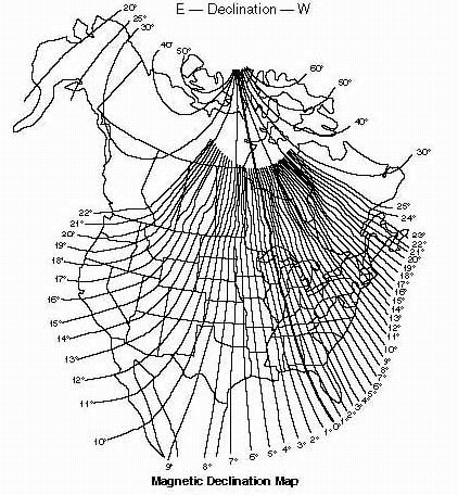
24 Longitude Line Rules Run North to South Measure distance in degrees from the Prime- Meridian Form half-circles that are equidistant from each other at the Equator, but converge at the poles. 0 Degrees Longitude is at Greenwich, England (established in 1883); 180 Degrees is in the Pacific, and is called the International Date Line (divides the Globe between two days).
25 The Degree is the basic unit of Latitude and Longitude A general location on the globe would be shown as 45 N, 75 W. A more precise location on the globe would be N, N.
26 How big is a Degree? Each degree in Latitude and Longitude is approximately 69 miles wide at the equator. Each degree can be divided into 60 subdivisions called minutes (1.15 miles in width ). 45 Each minute can be divided into 60 subdivisions called seconds (.019 miles, or 100 feet!). 35 So, your location on the globe can be very precisely identified, and would look like this: W.
27 Every spot on Earth has an address that is determined by referencing, in degrees, minutes and seconds, the latitude and longitude of that location.

28 Map Scale Map Scale expresses the relationship between the distance on a map and the true, corresponding distance of the same area of the Earth s surface. Mapmakers can't draw maps the same size as the area they represent; the maps would be too big. So they draw features smaller than they actually are.
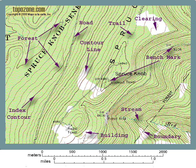
29 A map scale is usually given as a fraction (1/10000) or a ratio (1:10000) called a fractional scale USGS maps contain scales that have the same units on both sides of the ratio. Fractional scale
30 Bar Scale A bar scale is just a line drawn on a map of known ground length. There are usually distances marks along the line. Bar scales allow for quick visual estimation of distance.
31 Pay attention to where the zero point on the bar actually is when you measure with a bar scale! Notice that 0 is here!
32 Map Orientation A compass is usually used to determine cardinal direction A compass does not normally point to Geographic- North (True North) Magnetic North and Geographic- North (True North) are only the same in very few places. The direction in which the compass needle points is called Magnetic North, and the angle between magnetic north and true north is called Magnetic Declination.
33
34
35
36 Effect of Magnetic Declination Declination or Degrees Off Course Error Off Target after Walking 10 Miles feet (280meters) 5 4,600 feet (1,402 meters) 10 9,170 feet (2,795 meters)


37 Topographic Maps
38 -A Topographic Map is the representation, normally on a flat surface, of part of the Earth s surface, drawn to scale. -Topographic maps show distance relationships and elevation -Topography actually means, the shape, elevation and slope of the land.
39 Topographic Maps Different symbols and colors are used to indicate various features on topographic maps, including bodies of water and human-made structures. A topographic map of Portland, Maine shows various physical features of the area.
40 House Streams Woods Roads Topographic maps also include symbols that represent such features as woods, houses and roads.
41

42 - The distinctive characteristic of a Topographic Map is that the shape of the Earth s surface is shown by contour lines. - Contour Lines are imaginary lines that join points of equal elevation on the land above or below sea level. -How do we know where to put the lines when we make a map???
43 We could start with an island, and increase the level of the ocean the amount of our contour interval, an marking the shore line as we raise the water level.
44 10 feet above normal sea-level Notice that the shape of the island changes. Why?

45 20 feet above normal sea-level

46 30 feet above normal sea-level
47 Now, drain the water, and we have our topographic map!
48 But, how do they do it for real??
49
50
51

52
53 Ridge Valley Contour Lines make it possible to determine the shape of the land without looking at the actual spot.
54 Contour Lines Depending on the degree of elevation change there can be a few or many contour lines. The greater the elevation change the more contour lines there will be. To keep a map from being becoming clutter only certain elevations are represented by contour lines. The values are choose to be evenly spaced vertically. This spacing is call a contour interval. There are several different kinds of contour lines. Index contour Intermediate contour Depression contour
55 Index Contour (darker, has elevation) Intermediate Contour (lighter; does not have elevation identified)
56
57 Intermediate Contour
58 Depression Contour Lines Perp. Lines point downhill, into the depression Lip of depression is highest point
59 **Edge of depression is between
60 Stream Direction Determining stream direction of flow helps the map reader interpret elevations of intermediate contour lines above or below an Index Contour.
61 V s point uphill. Therefore, line A must be less than 900, and line B must be more than 900 A B
62 Contour Interval The difference between the elevation between adjacent contour lines Contour Interval

63

64 Total Distance between Index Contours = Number of Spaces between Index Contours =
65 Elevation increase between two identified points/distance between two horizontal points.
66 Slope Gentle Slope Steep Slope
67
68 Line A Distance =.5 miles Elevation Change = Slope =
69
70 Topographic Profiles Topographic Profiles

71
72

73
74
75

76 Vertical Exaggeration

77
Topographic Maps Practice Questions and Answers Revised October 2007
 Topographic Maps Practice Questions and Answers Revised October 2007 1. In the illustration shown below what navigational features are represented by A, B, and C? Note that A is a critical city in defining
Geography I Pre Test #1
 Geography I Pre Test #1 1. The sun is a star in the galaxy. a) Orion b) Milky Way c) Proxima Centauri d) Alpha Centauri e) Betelgeuse 2. The response to earth's rotation is a) an equatorial bulge b) polar
The Basics of Navigation
 The Basics of Navigation Knowledge of map reading and the use of the compass is an indispensable skill of bushcraft. Without this skill, a walker is a passenger and mere follower on a trip. To become a
Earth Coordinates & Grid Coordinate Systems
 Earth Coordinates & Grid Coordinate Systems How do we model the earth? Datums Datums mathematically describe the surface of the Earth. Accounts for mean sea level, topography, and gravity models. Projections
Lines on Maps and Globes. Cross Curricular Writing Activity Social Studies Grade 4
 Lines on Maps and Globes Cross Curricular Writing Activity Social Studies Grade 4 Fourth Grade Social Studies Standard Map: Chart/Globe The learner will be able to use maps, charts, graphs, and globes
Unit One Study Guide
 Unit One Study Guide Terms BCE: Before the Common Era. Referring to the time before Christ s birth. CE: Common Era. Referring to the time after Christ s birth. BC: Before Christ. Referring to the time
Coordinate Systems. Orbits and Rotation
 Coordinate Systems Orbits and Rotation Earth orbit. The earth s orbit around the sun is nearly circular but not quite. It s actually an ellipse whose average distance from the sun is one AU (150 million
EARTH SCIENCES - TYPES OF MAPS TEACHER GUIDE
 EARTH SCIENCES - TYPES OF MAPS TEACHER GUIDE MATERIALS: Electronic Reader - Maps 5 different types of maps (see lab) inflatable globes local topographical map Objective: To understand the uses and importance
SECOND GRADE 1 WEEK LESSON PLANS AND ACTIVITIES
 SECOND GRADE 1 WEEK LESSON PLANS AND ACTIVITIES UNIVERSE CYCLE OVERVIEW OF SECOND GRADE UNIVERSE WEEK 1. PRE: Discovering stars. LAB: Analyzing the geometric pattern of constellations. POST: Exploring
The Globe Latitudes and Longitudes
 INDIAN SCHOOL MUSCAT MIDDLE SECTION DEPARTMENT OF SOCIAL SCIENCE The Globe Latitudes and Longitudes NAME: CLASS VI SEC: ROLL NO: DATE:.04.2015 I NAME THE FOLLOWING: 1. A small spherical model of the Earth:
Maps A Primer for Content & Production of Topographic Base Maps For Design Presented by SurvBase, LLC
 Maps A Primer for Content & Production of Topographic Base Maps For Design Presented by Definition and Purpose of, Map: a representation of the whole or a part of an area. Maps serve a wide range of purposes.
An Introduction to Coordinate Systems in South Africa
 An Introduction to Coordinate Systems in South Africa Centuries ago people believed that the earth was flat and notwithstanding that if this had been true it would have produced serious problems for mariners
CONTENTS INTRODUCTION... 1 UNIT 1. PURPOSE OF MAPS... 3 1.1 MAP DEFINITION 1.2 MAP ACCURACY UNIT 2. CLASSIFICATION OF MAPS... 5 2.1 CATEGORIES 2.
 CONTENTS INTRODUCTION... 1 UNIT 1. PURPOSE OF MAPS... 3 1.1 MAP DEFINITION 1.2 MAP ACCURACY UNIT 2. CLASSIFICATION OF MAPS... 5 2.1 CATEGORIES 2.2 U.S. GEOLOGICAL SURVEY UNIT 3. MAP LEGEND... 9 3.1 MAP
Map Patterns and Finding the Strike and Dip from a Mapped Outcrop of a Planar Surface
 Map Patterns and Finding the Strike and Dip from a Mapped Outcrop of a Planar Surface Topographic maps represent the complex curves of earth s surface with contour lines that represent the intersection
CHAPTER 9 SURVEYING TERMS AND ABBREVIATIONS
 CHAPTER 9 SURVEYING TERMS AND ABBREVIATIONS Surveying Terms 9-2 Standard Abbreviations 9-6 9-1 A) SURVEYING TERMS Accuracy - The degree of conformity with a standard, or the degree of perfection attained
6. The greatest atmospheric pressure occurs in the 1) troposphere 3) mesosphere 2) stratosphere 4) thermosphere
 troposphere 3) mesosphere 2) stratosphere 4) thermosphere") 1. The best evidence of the Earth's nearly spherical shape is obtained through telescopic observations of other planets photographs of the Earth from an orbiting satellite observations of the Sun's altitude
1. The best evidence of the Earth's nearly spherical shape is obtained through telescopic observations of other planets photographs of the Earth from an orbiting satellite observations of the Sun's altitude
Solar Angles and Latitude
 Solar Angles and Latitude Objectives The student will understand that the sun is not directly overhead at noon in most latitudes. The student will research and discover the latitude ir classroom and calculate
The Earth Really is Flat! The Globe and Coordinate Systems. Long History of Mapping. The Earth is Flat. Long History of Mapping
 The Earth Really is Flat! The Globe and Coordinate Systems Intro to Mapping & GIS The Earth is Flat Day to day, we live life in a flat world sun rises in east, sets in west sky is above, ground is below
OBJECTIVES. Identify the means by which latitude and longitude were created and the science upon which they are based.
 Name: Key OBJECTIVES Correctly define: isolines, gradient, topographic map, contour interval, hachured lines, profile, latitude, longitude, hydrosphere, lithosphere, atmosphere, elevation, model EARTH
Lines of Latitude and Longitude
 ED 5661 Mathematics & Navigation Teacher Institute Keith Johnson Lesson Plan Lines of Latitude and Longitude Lesson Overview: This lesson plan will introduce students to latitude and longitude along with
Watershed Delineation
 ooooo Appendix D: Watershed Delineation Department of Environmental Protection Stream Survey Manual 113 Appendix D: Watershed Delineation Imagine a watershed as an enormous bowl. As water falls onto the
compass Encyclopedic Entry
 This website would like to remind you: Your browser (Apple Safari 7) is out of date. Update your browser for more security, comfort and the best experience on this site. Encyclopedic Entry compass For
Gravitational potential
 Gravitational potential Let s assume: A particle of unit mass moving freely A body of mass M The particle is attracted by M and moves toward it by a small quantity dr. This displacement is the result of
Stage 4. Geography. Blackline Masters. By Karen Devine
 1 Devine Educational Consultancy Services Stage 4 Geography Blackline Masters By Karen Devine Updated January 2010 2 This book is intended for the exclusive use in NSW Secondary Schools. It is meant to
UTM: Universal Transverse Mercator Coordinate System
 Practical Cartographer s Reference #01 UTM: Universal Transverse Mercator Coordinate System 180 174w 168w 162w 156w 150w 144w 138w 132w 126w 120w 114w 108w 102w 96w 90w 84w 78w 72w 66w 60w 54w 48w 42w
The Map Grid of Australia 1994 A Simplified Computational Manual
 The Map Grid of Australia 1994 A Simplified Computational Manual The Map Grid of Australia 1994 A Simplified Computational Manual 'What's the good of Mercator's North Poles and Equators, Tropics, Zones
Searching Land Records thru the BLM General Land Office Records.
 Searching Land Records thru the BLM General Land Office Records. Land Records can be an exciting addition to your family history search. The United States Government transferred ownership of land to millions
Weekend Cabin Retreat Project Site Plans
 Weekend Cabin Retreat Project Site Plans Sacramento City College EDT 300/ENGR 306 EDT 300/ENGR 306 - Site Plans 1 Cabin Project Site Plan/Bubble Diagram - Assignment 1 =10-0 Floor Plan - Assignment 1/4
Measuring Your Latitude from the Angle of the Sun at Noon
 Measuring Your Latitude from the Angle of the Sun at Noon Background: You can measure your latitude in earth's northern hemisphere by finding out the altitude of the celestial equator from the southern
Basic Elements of Reading Plans
 Center for Land Use Education and Research at the University of Connecticut Basic Elements of Reading Plans University of Connecticut. The University of Connecticut supports all state and federal laws
Measuring the Earth Using a GPS M. Scott Wilkerson & M. Beth Wilkerson, DePauw University, May 10, 2007
 Measuring the Earth Using a GPS M. Scott Wilkerson & M. Beth Wilkerson, DePauw University, May 10, 2007 Modified from: Kerski, J.J., 2007, Measuring the Earth s Circumference with GPS, Copyright ESRI,
Topographic Survey. Topographic Survey. Topographic Survey. Topographic Survey. CIVL 1101 Surveying - Introduction to Topographic Modeling 1/8
 IVL 1 Surveying - Introduction to Topographic Modeling 1/8 Introduction Topography - defined as the shape or configuration or relief or three dimensional quality of a surface Topography maps are very useful
Pre and post-visit activities - Navigating by the stars
 Pre and post-visit activities - Navigating by the stars Vocabulary List Adult Education at Scienceworks Pre-visit Activity 1: What is longitude and latitude? Activity 2: Using the Southern Cross to find
Basic Map & GPS Skills. How to read a topographic map, use a compass, and determine GPS locations on a map
 Basic Map & GPS Skills How to read a topographic map, use a compass, and determine GPS locations on a map Table of Contents This booklet covers what a topographic map (topo map) is, how to use a map, and
Amendment List Date Amended by Incorporated No Date 1 2 3 4 5 6 7 8 9 10 11 12 13 14 15 16 i
 No Amendment List Date Amended by Date Incorporated 1 2 3 4 5 6 7 8 9 10 11 12 13 14 15 16 i ACP 32 NAVIGATION CONTENTS Volume 1... Map reading Volume 2... Basic Navigation Volume 3... Air Navigation Volume
Plate Tectonics: Ridges, Transform Faults and Subduction Zones
 Plate Tectonics: Ridges, Transform Faults and Subduction Zones Goals of this exercise: 1. review the major physiographic features of the ocean basins 2. investigate the creation of oceanic crust at mid-ocean
Laboratory 6: Topographic Maps
 Name: Laboratory 6: Topographic Maps Part 1: Construct a topographic map of the Egyptian Pyramid of Khafre A topographic map is a two-dimensional representation of a three-dimensional space. Topographic
WGS AGD GDA: Selecting the correct datum, coordinate system and projection for north Australian applications
 internal report WGS AGD GDA: Selecting the correct datum, coordinate system and projection for north Australian applications JBC Lowry Hydrological and Ecological Processes Program Environmental Research
World Map Lesson 4 - The Global Grid System - Grade 6+
 World Map Lesson 4 - The Global Grid System - Grade 6+ Activity Goal To use the global grid system of latitude and longitude to find specific locations on a world map. Materials Needed: A pencil, a ruler,
Learning about GPS and GIS
 Learning about GPS and GIS Standards 4.4 Understand geographic information systems (G.I.S.). B12.1 Understand common surveying techniques used in agriculture (e.g., leveling, land measurement, building
CONTENTS. Page 3 What is orienteering? Page 4 Activity: orienteering map bingo. Page 5 Activity: know your colours. Page 6 Choosing your compass
 THE RIGHT DIRECTION SCOUT ORIENTEER ACTIVITY BADGE CONTENTS Page What is orienteering? Page 4 Activity: orienteering map bingo Page 5 Activity: know your colours Page 6 Choosing your compass Page 7 Activity:
4 The Rhumb Line and the Great Circle in Navigation
 4 The Rhumb Line and the Great Circle in Navigation 4.1 Details on Great Circles In fig. GN 4.1 two Great Circle/Rhumb Line cases are shown, one in each hemisphere. In each case the shorter distance between
SESSION 8: GEOGRAPHIC INFORMATION SYSTEMS AND MAP PROJECTIONS
 SESSION 8: GEOGRAPHIC INFORMATION SYSTEMS AND MAP PROJECTIONS KEY CONCEPTS: In this session we will look at: Geographic information systems and Map projections. Content that needs to be covered for examination
Basic Coordinates & Seasons Student Guide
 Name: Basic Coordinates & Seasons Student Guide There are three main sections to this module: terrestrial coordinates, celestial equatorial coordinates, and understanding how the ecliptic is related to
Lecture 2. Map Projections and GIS Coordinate Systems. Tomislav Sapic GIS Technologist Faculty of Natural Resources Management Lakehead University
 Lecture 2 Map Projections and GIS Coordinate Systems Tomislav Sapic GIS Technologist Faculty of Natural Resources Management Lakehead University Map Projections Map projections are mathematical formulas
6 th Grade Vocabulary-ALL CAMPUSES
 6 th Grade Vocabulary-ALL CAMPUSES 6.1 History. The student understands that historical events influence contemporary events. (B) analyze the historical background of the United States to evaluate relationships
Chapter 5: Working with contours
 Introduction Contoured topographic maps contain a vast amount of information about the three-dimensional geometry of the land surface and the purpose of this chapter is to consider some of the ways in
UTM Zones for the US UTM UTM. Uniform strips Scalable coordinates
 UTM UTM Uniform strips Scalable coordinates Globally consistent, most popular projection/coordinate system for regional to global scale geospatial data (i.e. satellite images global scale datasets USGS/EDC)
Module 11: The Cruise Ship Sector. Destination #3
 Module 11: The Cruise Ship Sector Destination #3 Cruise Destinations Welcome to your third destination. Use the following resource article to learn about the different oceans and time zones. Seen from
PREFACE. The many TRADOC service schools and DOD agencies that produce the ACCP materials administered by the AIPD develop them to the DETC standards.
 PREFACE The Army Institute for Professional Development (AIPD) administers the consolidated Army Correspondence Course Program (ACCP), which provides highquality, economical training to its users. The
Navigation: Latitude and Longitude
 Sextants and Chronometers Help Sailors Find Their Position at Sea Latitude lines run horizontally across the globe and are used to measure distances north and south of the equator. Sailors used a sextant
Topo Grabber Help. 2010 Fountain Computer Products
 Topo Grabber Help Topo Grabber Help All rights reserved. No parts of this work may be reproduced in any form or by any means - graphic, electronic, or mechanical, including photocopying, recording, taping,
CK-12 Earth Science For High School Workbook
 CK-12 Earth Science For High School Workbook Say Thanks to the Authors Click http://www.ck12.org/saythanks (No sign in required) www.ck12.org To access a customizable version of this book, as well as other
USING MAPS AND GLOBES
 USING MAPS AND GLOBES Grade Level or Special Area: 4 th Grade Written by: Krystal Kroeker, Colorado Springs Charter Academy, Colorado Springs, CO Length of Unit: Five lessons (approximately one week (five
ES 106 Laboratory # 3 INTRODUCTION TO OCEANOGRAPHY. Introduction The global ocean covers nearly 75% of Earth s surface and plays a vital role in
 ES 106 Laboratory # 3 INTRODUCTION TO OCEANOGRAPHY 3-1 Introduction The global ocean covers nearly 75% of Earth s surface and plays a vital role in the physical environment of Earth. For these reasons,
The following words and their definitions should be addressed before completion of the reading:
 Seasons Vocabulary: The following words and their definitions should be addressed before completion of the reading: sphere any round object that has a surface that is the same distance from its center
Stellarium a valuable resource for teaching astronomy in the classroom and beyond
 Stellarium 1 Stellarium a valuable resource for teaching astronomy in the classroom and beyond Stephen Hughes Department of Physical and Chemical Sciences, Queensland University of Technology, Gardens
Sun Earth Relationships
 1 ESCI-61 Introduction to Photovoltaic Technology Sun Earth Relationships Ridha Hamidi, Ph.D. Spring (sun aims directly at equator) Winter (northern hemisphere tilts away from sun) 23.5 2 Solar radiation
Celestial Observations
 Celestial Observations Earth experiences two basic motions: Rotation West-to-East spinning of Earth on its axis (v rot = 1770 km/hr) (v rot Revolution orbit of Earth around the Sun (v orb = 108,000 km/hr)
Map reading made easy
 Map reading made easy What is a map? A map is simply a plan of the ground on paper. The plan is usually drawn as the land would be seen from directly above. A map will normally have the following features:
WE VE GOT THE WHOLE WORLD IN OUR HANDS: Geography Spatial Sense
 WE VE GOT THE WHOLE WORLD IN OUR HANDS: Geography Spatial Sense Grade Level: Written by: Length of Unit: Third Grade Wendy S. Hyndman, The Classical Academy, Colorado Springs, CO Doreen W. Jennings, Lincoln
Chapter 4: The Concept of Area
 Chapter 4: The Concept of Area Defining Area The area of a shape or object can be defined in everyday words as the amount of stuff needed to cover the shape. Common uses of the concept of area are finding
Organizing a class orienteering event
 Organizing a class orienteering event Orienteering is a wonderful teaching tool. It allows the teacher to illustrate many abstract ideas in concrete terms. The sport also appeals to students operating
Grades 3-5. Benchmark A: Use map elements or coordinates to locate physical and human features of North America.
 Grades 3-5 Students use knowledge of geographic locations, patterns and processes to show the interrelationship between the physical environment and human activity, and to explain the interactions that
Geography affects climate.
 KEY CONCEPT Climate is a long-term weather pattern. BEFORE, you learned The Sun s energy heats Earth s surface unevenly The atmosphere s temperature changes with altitude Oceans affect wind flow NOW, you
ebb current, the velocity alternately increasing and decreasing without coming to
 Slack water (slack tide): The state of a tidal current when its velocity is near zero, especially the moment when a reversing current changes its direction and its velocity is zero. The term is also applied
NGA GRID GUIDE HOW TO USE ArcGIS 8.x ANS 9.x TO GENERATE MGRS AND OTHER MAP GRIDS
 GEOSPATIAL SCIENCES DIVISION COORDINATE SYSTEMS ANALYSIS TEAM (CSAT) SEPTEMBER 2005 Minor Revisions March 2006 POC Kurt Schulz NGA GRID GUIDE HOW TO USE ArcGIS 8.x ANS 9.x TO GENERATE MGRS AND OTHER MAP
What are map projections?
 Page 1 of 155 What are map projections? ArcGIS 10 Within ArcGIS, every dataset has a coordinate system, which is used to integrate it with other geographic data layers within a common coordinate framework
Geometry Notes PERIMETER AND AREA
 Perimeter and Area Page 1 of 57 PERIMETER AND AREA Objectives: After completing this section, you should be able to do the following: Calculate the area of given geometric figures. Calculate the perimeter
Chapter 4: Representation of relief
 Introduction To this point in our discussion of maps we have been concerned only with their planimetric properties, those relating to the location of features in two-dimensional space. But of course we
Inside Earth Chapter 3
 Name Hour Due Date Inside Earth Chapter Page 1 Volcanoes and Plate Tectonics Page 2 Volcanic Activity Page - Mapping Earthquakes and Volcanoes Page 4 Mapping Earthquakes and Volcanoes table Page 5 - Mapping
Thematic Map Types. Information Visualization MOOC. Unit 3 Where : Geospatial Data. Overview and Terminology
 Thematic Map Types Classification according to content: Physio geographical maps: geological, geophysical, meteorological, soils, vegetation Socio economic maps: historical, political, population, economy,
MAP READING AND NAVIGATION
 Emergency Management Australia MAP READING AND NAVIGATION safer sustainable communities Emergency Management Australia is a Division of the Attorney-General s Department PART IV Skills for Emergency Services
WILD 3710 Lab 3: GIS Data Exploration Camp W.G. Williams
 WILD 3710 Lab 3: GIS Data Exploration Camp W.G. Williams -Laboratory- TAs and Lab Instructors: Chris McGinty chris@gis.usu.edu Office: JQL 146 Office Hours: W 2:30 3:30 or by appt. Alex Hernandez alex@gis.usu.edu
Southern AER Atmospheric Education Resource
 Southern AER Atmospheric Education Resource Vol. 9 No. 5 Spring 2003 Editor: Lauren Bell In this issue: g Climate Creations exploring mother nature s remote control for weather and Climate. g Crazy Climate
Seasonal & Daily Temperatures. Seasons & Sun's Distance. Solstice & Equinox. Seasons & Solar Intensity
 Seasonal & Daily Temperatures Seasons & Sun's Distance The role of Earth's tilt, revolution, & rotation in causing spatial, seasonal, & daily temperature variations Please read Chapter 3 in Ahrens Figure
Satellite Pursuit: Tracking Marine Mammals
 : Tracking Marine Mammals Material adapted from: Monterey Bay Research Institute, EARTH: Satellite Tracking OPB NOVA Teachers: Ocean Animal Emergency Teach Engineering: Marine Animal Tracking Introduction:
ACTIVITY 1 Hemispheres of the World
 Name Date Class CTIVITY 1 s of the World Directions: Use your textbook to answer the questions below. 1. What line of latitude is used to divide the earth into Northern and Southern s? 2. What line of
Appendix E FAA ALP Sheet Checklist
 Appendix E FAA ALP Sheet Checklist AC 150/5070-6B (incl. Chg. 1, 5/1/07) Airport Layout Plan Drawing Set The following list provides general guidelines in preparing the Airport Layout Plan set. The individual
11.1. Objectives. Component Form of a Vector. Component Form of a Vector. Component Form of a Vector. Vectors and the Geometry of Space
 11 Vectors and the Geometry of Space 11.1 Vectors in the Plane Copyright Cengage Learning. All rights reserved. Copyright Cengage Learning. All rights reserved. 2 Objectives! Write the component form of
1 213 Ref: Compass, Boxing, Heading C A vessel heading ENE is on a course of. A. 022.5 C. 067.5 B. 045.0 D. 090.0
 1 213 Ref: Compass, Boxing, Heading C A vessel heading ENE is on a course of. A. 022.5 C. 067.5 B. 045.0 D. 090.0 2 214 Ref: Compass, Boxing, Heading A A vessel heading ESE is on a course of. A. 112.5
How to analyze synoptic-scale weather patterns Table of Contents
 How to analyze synoptic-scale weather patterns Table of Contents Before You Begin... 2 1. Identify H and L pressure systems... 3 2. Locate fronts and determine frontal activity... 5 3. Determine surface
How do you find a place on a globe? How do you look up a place based on latitude and longitude?
 Why are globes tilted? Most Replogle globes are made to tilt at an angle of 23.5º to match the actual tilt of the earth in relationship to our sun. Incidentally, it is this tilting of the earth relative
CHAPTER 4 LEGAL DESCRIPTION OF LAND DESCRIBING LAND METHODS OF DESCRIBING REAL ESTATE
 r CHAPTER 4 LEGAL DESCRIPTION OF LAND DESCRIBING LAND A legal description is a detailed way of describing a parcel of land for documents such as deeds and mortgages that will be accepted in a court of
INTRODUCTION TO LAND NAVIGATION
 Section 5 INTRODUCTION TO LAND NAVIGATION Key Points 1 Understanding Azimuths 2 Converting Azimuths 3 Determining Elevation 4 Calculating Distance on a Map Tactics and Techniques Track Introduction to
Week 1. Week 2. Week 3
 Week 1 1. What US city has the largest population? 2. Where is Aachen? 3. What is the capitol of Florida? 4. What is the longest mountain range in Spain? 5. What countries border Equador? Week 2 1. What
Motion & The Global Positioning System (GPS)
") Grade Level: K - 8 Subject: Motion Prep Time: < 10 minutes Duration: 30 minutes Objective: To learn how to analyze GPS data in order to track an object and derive its velocity from positions and times.
Grade Level: K - 8 Subject: Motion Prep Time: < 10 minutes Duration: 30 minutes Objective: To learn how to analyze GPS data in order to track an object and derive its velocity from positions and times.
Plotting Earthquake Epicenters an activity for seismic discovery
 Plotting Earthquake Epicenters an activity for seismic discovery Tammy K Bravo Anne M Ortiz Plotting Activity adapted from: Larry Braile and Sheryl Braile Department of Earth and Atmospheric Sciences Purdue
CHAPTER 7 DEAD RECKONING
 CHAPTER 7 DEAD RECKONING DEFINITION AND PURPOSE 700. Definition and Use Dead reckoning is the process of determining one s present position by projecting course(s) and speed(s) from a known past position,
Review 1. Multiple Choice Identify the choice that best completes the statement or answers the question.
 Review 1 Multiple Choice Identify the choice that best completes the statement or answers the question. 1. When hydrogen nuclei fuse into helium nuclei a. the nuclei die. c. particles collide. b. energy
How To Read Maps And Aerial Photos
 3 Read Maps and Aerial Photos WRITING SAMPLE (training guide) Stephen X. Arthur, technical writer 2005 www.transcanfilm.com/stephenarthur First draft. Copyright 1996, BC Ministry of Forests / BC Institute
FM 3-25.26 MAP READING AND LAND NAVIGATION
 *FM 3-25.26 (FM 21-26) Field Manual No. 3-25.26 Headquarters Department of the Army Washington, DC, 20 July 2001 FM 3-25.26 MAP READING AND LAND NAVIGATION Table of Contents PREFACE Part One MAP READING
LABORATORY TWO GEOLOGIC STRUCTURES
 EARTH AND ENVIRONMENT THROUGH TIME LABORATORY- EES 1005 LABORATORY TWO GEOLOGIC STRUCTURES Introduction Structural geology is the study of the ways in which rocks or sediments are arranged and deformed
GEOGRAPHIC INFORMATION SYSTEMS CERTIFICATION
 GEOGRAPHIC INFORMATION SYSTEMS CERTIFICATION GIS Syllabus - Version 1.2 January 2007 Copyright AICA-CEPIS 2009 1 Version 1 January 2007 GIS Certification Programme 1. Target The GIS certification is aimed
Full credit for this chapter to Prof. Leonard Bachman of the University of Houston
 Chapter 6: SOLAR GEOMETRY Full credit for this chapter to Prof. Leonard Bachman of the University of Houston SOLAR GEOMETRY AS A DETERMINING FACTOR OF HEAT GAIN, SHADING AND THE POTENTIAL OF DAYLIGHT PENETRATION...
BASICS OF PRECISION AGRICULTURE (PA)
") BASICS OF PRECISION AGRICULTURE (PA) specific production on particular place specific production, from foot to foot... Same sense: data collection and decision making for small pieces of the field. Particular
BASICS OF PRECISION AGRICULTURE (PA) specific production on particular place specific production, from foot to foot... Same sense: data collection and decision making for small pieces of the field. Particular
Algebra Geometry Glossary. 90 angle
 lgebra Geometry Glossary 1) acute angle an angle less than 90 acute angle 90 angle 2) acute triangle a triangle where all angles are less than 90 3) adjacent angles angles that share a common leg Example:
Orientation to the Sky: Apparent Motions
 Chapter 2 Orientation to the Sky: Apparent Motions 2.1 Purpose The main goal of this lab is for you to gain an understanding of how the sky changes during the night and over the course of a year. We will
To successfully manage your land, you need to
 Land Survey and Mapping An Introduction for Woodland Owners PNW 581 March 2015 Tristan Huff To successfully manage your land, you need to know what you have. Surveying and mapping are two interrelated
Number Sense and Operations
 Number Sense and Operations representing as they: 6.N.1 6.N.2 6.N.3 6.N.4 6.N.5 6.N.6 6.N.7 6.N.8 6.N.9 6.N.10 6.N.11 6.N.12 6.N.13. 6.N.14 6.N.15 Demonstrate an understanding of positive integer exponents