GCSE GEOGARPHY OCR B REVISION GUIDE Natural Hazards
|
|
|
- Betty Willis
- 9 years ago
- Views:
Transcription
1 GCSE GEOGARPHY OCR B REVISION GUIDE Natural Hazards Tectonic Hazards A natural hazard is an extreme natural event or process that causes loss of life and/or extreme damage to property and creates severe disruption to human activities

2 Structure of the earth Crust Outer Core Mantle Inner Core Crust Mantle Core Characteristics The crust is the outer layer of the earth. It is a thin layer between 0-60km thick. The crust is the solid rock layer upon which we live. There are two different types of crust: continental crust, which carries land, and oceanic crust, which carries water. The mantle is the widest section of the earth. It has a diameter of approximately 2900km. The mantle is made up of semi-molten rock called magma. In the upper parts of the mantle the rock is hard, but lower down, nearer the inner core, the rock is soft and beginning to melt. The inner core is in the centre of the earth and is the hottest part of the earth. The inner core is solid. It is made up of iron and nickel with temperatures of up to 5500 C. With its immense heat energy, the inner core is like the engine room of the Earth. The outer core is the layer surrounding the inner core. It is a liquid layer, also made up of iron and nickel. It is still extremely hot here, with temperatures similar to the inner core. 0-60km 2900km Depth km km

3 Plate Boundaries of the earth The tectonic plates are moving in different directions. The movements have different effects on the landscape of the Earth. Plates that are moving in opposite directions form a constructive boundary. Plates that move towards each other form either a destructive boundary or a collision boundary. Plates sliding by each other form a conservative boundary. Plates and plate boundaries The earth's crust is broken up into pieces. These pieces are called plates. Heat rising and falling inside the mantle creates convection currents. The convection currents move the plates. The movement of the plates, and the activity inside the earth, is called plate tectonics. Plate tectonics cause earthquakes and volcanoes. The point where two plates meet is called a plate boundary. Earthquakes and volcanoes are most likely to occur either on or near plate boundaries.

4 Plate Boundary Diagram Description Example Tensional / Constructive (divergent ) plate boundaries Constructive plate boundaries occur when two plates move away from each other North American and Eurasian Plate Compressional / Destructive (subduction zones) plate boundaries Destructive plate boundaries occur when an oceanic plate is forced under (or subducts) a continental plate Pacific Plate and the Eurasian Plate Conservative (transform faults) plate boundaries Conservative plate boundaries occur when two plates slide past each other. North American Plate and the Pacific Plate Collision plate boundaries Collision plate boundaries occur when two continental plates move towards each other. Indo- Australian and the Eurasian Plate Plates behave differently at different plate boundaries: At a constructive or divergent boundary the plates move apart. At a destructive or convergent boundary the plates move towards each other. At a conservative or transform boundary the plates slide past each other.

5 Complete the table below as a revision task without referring to any books! Type of plate margin Description of changes Earthquake/volcanic activity Examples Convergent (oceanic and continental) Convergent (two continental) Divergent on land Divergent under the ocean Transform
 Convergent")
6 Volcanoes Why do people live close to volcanoes? Volcanoes have a wide range of effects on humans. These can be problematic or beneficial. It is usually the destructive nature of volcanoes which is more widely documented. However, many people rely on volcanoes for their everyday survival. Today, many millions of people live close to volcanoes for this very reason. People live close to volcanoes because Geothermal energy can be harnessed by using the steam from underground which has been heated by the Earth's magma. This steam is used to drive turbines in geothermal power stations to produce electricity for domestic and industrial use. Countries such as Iceland and New Zealand use this method of generating electricity. Volcanoes attract millions of visitors around the world every year. Apart from the volcano itself, hot springs and geysers can also bring in the tourists. This creates many jobs for people in the tourism industry. This includes work in hotels, restaurants and gift shops. Often locals are also employed as tour guides. Lava from deep within the earth contains minerals which can be mined once the lava has cooled. These include gold, silver, diamonds, copper and zinc, depending on their mineral composition. Often, mining towns develop around volcanoes.

7 Volcanic areas often contain some of the most mineral rich soils in the world. This is ideal for farming. Lava and material from pyroclastic flows are weathered to form nutrient rich soil which can be cultivated to produce healthy crops and rich harvests.

8 Fill this table in from memory when you have studied and learnt the above diagram Destructive composite oceanic/continental Hot spot shield Constructive Destructive composite - continental Margin type Volcano type Eruption products Diagram of volcano Detail on formation Examples

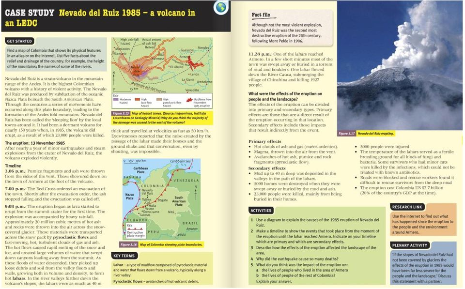
9 Nevado Del Ruiz case study Nevado del Ruiz is the northernmost of several Colombian stratovolcanoes in the Andes Volcanic Chain of western South America. The Andean volcanic belt is generated by the eastward subduction of the Nazca oceanic plate beneath the South American continental plate. Typically, such stratovolcanoes generate explosive Plinian eruptions with associated pyroclastic flows that can melt snow and glaciers near the summit, thus producing devastating lahars. After nearly a year of minor earthquakes and steam explosions from Nevado del Ruiz, the volcano exploded violently on November 13, The initial blast began at 3:06 p.m., and two hours later pumice fragments and ash were showering down on Armero. However, the citizens of Armero remained calm. They were placated by reassuring messages from the mayor over radio, and from a local priest over the church public address system. Nevertheless, the Red Cross ordered an evacuation of the town at 7:00 p.m. However, shortly after the evacuation order the ash stopped falling and the evacuation was called off. At 9:08 p.m., just as calm was being restored, molten rock began to erupt from the summit crater for the first time (all previous eruptions were steam explosions). The violent ejection of this molten rock generated hot pyroclastic flows and airfall tephra that began to melt the summit ice cap. Unfortunately, a storm obscured the summit area so that most citizens were unaware of the pyroclastic eruption. Meltwater quickly mixed with the erupting pyroclastic fragments to generate a series of hot lahars. One lahar flowed down the River Cauca, submerging the village Chinchina and killing 1,927

10 people. Other lahars followed the paths of the 1595 and 1845 mudflows. Travelling at 50 kilometers per hour, the largest of these burst through an upstream damn on the River Lagunillas and reached Armero two hours after the eruption began. Most of the town was swept away or buried in only a few short minutes, killing three quarters of the townspeople.

11
12 Mt Etna Mt Etna Volcano is one of the world's most active volcanoes. It has been erupting since several million years. Mt Etna is one of the greatest and beautiful volcano adventure tour destinations in Sicily, beside many other which can be easily enjoyed from our charming village of Taormina. This volcano has more than 400 craters, split all over the Catania county. To the ancient Greeks, Mount Etna was the realm of Vulcan, god of fire, and the home of the one-eyed monster known as the Cyclops. Etna offers skiing in the Winter months and breathtaking hikes in the woods during the Summer. There are also a number of smaller peaks on the slopes of Etna, and some interesting caverns. Since Etna is a strato volcano, with relatively cool lava temperatures and numerous openings (vents), nobody ever knows precisely where on its vast surface the next eruption will be.

13

14 Management of volcanoes Volcanologists people who study volcanoes are skilled at predicting the likelihood of an eruption. However, it is difficult to pinpoint when an eruption will happen. The movement of magma may be detected, but often no eruption occurs. Instead it cools below the surface. Monitoring potential eruptions is expensive. With many volcanoes erupting only every few hundred years, it's not possible to monitor every site.

15 Earthquakes Earthquakes are vibrations of the earth s crust caused by movement at plate boundaries and major fault lines. The red areas on the map are where earthquakes are most Main Concepts Earthquakes occur along faults, which are large cracks in the earth s crust. Most of these are associated with the larger plate boundaries, along which the largest earthquakes usually occur.

. Earthquakes can happen along any type of plate boundary.")

16 They are caused by the sudden jerking movements of the fault, either laterally or vertically, and are almost impossible to predict. An earthquake is the shaking and vibration of the crust due to movement of the Earth's plates (plate tectonics). Earthquakes can happen along any type of plate boundary. Earthquakes are caused when the tension is released from inside the crust. This happens because plates do not move smoothly - sometimes they get stuck. When this happens a great deal of pressure builds up. When this pressure is eventually released, an earthquake tends to occur. The point inside the Earth's crust where the pressure is released is called the focus. The point above the focus, on the Earth's surface is called the epicentre. In an earthquake, energy is released in the form of waves. These are called seismic waves. The waves spread out from the focus. The strongest waves are found near the centre of the earthquake. This means that the most severe damage caused by an earthquake will happen close to the epicentre. The diagram above illustrates how the movement of two plates at the plate boundary creates pressure deep inside the Earth. This is the focus. This pressure travels up to the Earth's crust and escapes at the epicentre of the earthquake. The pressure, released at the epicentre, travels outwards in all directions in rings (seismic waves). The waves are felt most strongly at the epicentre, becoming less strong as they travel further away.

17 Earthquakes are measured in two ways: - The Richter scale measures the magnitude of an earthquake using an instrument called a seismograph. The Richter scale is logarithmic, meaning that an earthquake measuring 7 is 10 times more powerful than one measuring 6, and 100 times more powerful than one measuring 5. - The mercalli scale measures the damage caused by an earthquake. It rates each quake from I to XII, depending on how much damage was done, and is dependent not only on the magnitude of the earthquake but also the depth of the earthquake. The point at which an earthquake actually begins, deep below the earth s surface is called the focus. If the focus is deep then the effects of the earthquake may be less as the shockwaves have more rock to move through. Obviously this also depends on what type of rock it is. The point directly above the focus, on the earth s surface, is called the epicentre. The effects of the earthquake are usually worst here, and then radiate out from this spot. Effects of Earthquakes The effects of an earthquake can be easily split up into two sections. Primary effects are those that occur immediately as the earthquake happens. These include buildings collapsing, roads and bridges being destroyed and railway lines being buckled. All occur due to the shaking of the ground. Secondary effects are the subsequent effects of the quake, and can be even more devastating then the primary ones. The main secondary effects are: - Fires: usually from ruptured gas lines. This was the main cause of death and damage after the San Francisco earthquake in Tidal waves: A tidal waves caused by an earthquake is called a tsunami. They can travel very quickly across entire oceans, before engulfing land 1000 s of miles away. The 1964 Alaskan earthquake caused considerable damage in several Californian coastal areas. Although Los Angeles has escaped so far, its is still considered to be a tsunami hazard prone area - Landslides can often be triggered by earthquakes, causing huge amounts of material to be moved very quickly. This is actually what occurred just before the volcanic eruption on Mt. St. Helens. They are most likely to occur where the land is steep, saturated or weak. - Diseases can spread very quickly in the unsanitary conditions often left behind by massive earthquakes. Water becomes contaminated very quickly, and in Less Economically Developed Countries (LEDC s) especially; access for the medical services can be badly hampered by the


18 damage caused by the quake. The most common diseases to be associated with earthquakes are therefore water-borne ones like cholera and typhoid.

19

20
21 The Impact of Natural Hazards MEDC s v LEDC s Natural hazards will affect More Economically Developed Countries (MEDC s) in a differing way to those that occur in Less Economically Developed Countries (LEDC s). - Health Care: MEDC s have the medical resources and money to quickly get appropriate aid to areas after a natural disaster. LEDC s often have to rely on aid from overseas as their health system, which is inadequate. This overseas aid takes time to arrive, which could mean far more casualties. - Emergency Services: In MEDC s who have a volcanic or earthquake risk, such as Japan and New Zealand, there are well thought out emergency procedures. Practices in schools and places of work mean that people know what to do it the event of a natural disaster. The Government s and military have special emergency plans to help with the situation. Often LEDC s do not have these emergency plans, and so far more damage can be done before the emergency services reach the stricken area. - Building Technology: Countries such as Japan and the United States have been at the forefront of developing buildings that have more chance of resisting an earthquake. Most houses in San Francisco are made of wood, to make them more flexible and allow them to move with the quake. Larger skyscrapers are built with flexible foundations, which literally allow them to sway during a quake, rather than being rigid and falling down. Many countries in areas prone to natural hazards have building codes to say where they can and cannot build, and how high the buildings can be. New Zealand is a good example of where this occurs. LEDC s don t tend to have the technology available or money to pay for it, and so often their buildings are very susceptible to earthquakes. - Scientific Prediction: Scientists work throughout the world, trying to predict earthquakes and volcanoes. So far they have found it very difficult to predict earthquakes, although scientists monitoring the San Andreas Fault in California have planted a huge number of seismographs in the ground to try to detect even the faintest of tremors. Volcanoes generally are easier to predict, although the specific time of the eruption is not so easy to do. Scientists can measure changes within the mountain that helps them to predict that the volcano is going to erupt. This usually allows the Local Authorities sufficient time to evacuate people from the danger area (as seen at both Mt. St. Helens and Mt. Pinatubo). However they still find it very difficult to accurately predict the size of the eruption. MEDC s do tend to have more investment for this type of research and development than LEDC s. Recovery: MEDC s tend to be able to recover quickly from a natural disaster, due to having the investment and technology needed to return the area to as good as new as soon as possible. Because LEDC s often have to rely on aid from overseas, this quick recovery is often impossible for them.
22
23 Tropical Storms A tropical storm is a large depression or cyclone that forms over tropical seas and moves away from the equator. Tropical cyclones are like engines that require warm, moist air as fuel. So the first ingredient needed for a tropical cyclone is warm ocean water. That is why tropical cyclones form only in tropical regions where the ocean is at least 27 C for at least the top 60m below the surface. The second ingredient for a tropical cyclone is wind. In the case of hurricanes that form in the Atlantic Ocean, the wind blowing westward across the Atlantic from Africa provides the necessary ingredient. As the wind passes over the ocean s surface, water evaporates (turns into water vapour) and rises. As it rises, the water vapour cools, and condenses back into large water droplets, forming large cumulonimbus clouds. These clouds are just the beginning! Happen between May and November in the northern hemisphere and November and April in southern hemisphere
24
25

26

27 Drought
28 How to create a stoneline 1. Work out which way water flows mark out contours on the ground 2. To find contours water finds own level use plastic tube filled with water attached to measuring post. When water levels are the same found contour 3. Mark contour out on ground 4. Willing helpers bring local people together and think of solutions get everyone involved 5. Get large stones place along the contours to form a low wall 6. Fill in wall with smaller stones to prevent soil being washed away
29
30
31
Rapid Changes in Earth s Surface
 TEKS investigate rapid changes in Earth s surface such as volcanic eruptions, earthquakes, and landslides Rapid Changes in Earth s Surface Constant Changes Earth s surface is constantly changing. Wind,
TECTONICS ASSESSMENT
 Tectonics Assessment / 1 TECTONICS ASSESSMENT 1. Movement along plate boundaries produces A. tides. B. fronts. C. hurricanes. D. earthquakes. 2. Which of the following is TRUE about the movement of continents?
Regents Questions: Plate Tectonics
 Earth Science Regents Questions: Plate Tectonics Name: Date: Period: August 2013 Due Date: 17 Compared to the oceanic crust, the continental crust is (1) less dense and more basaltic (3) more dense and
Interactive Plate Tectonics
 Interactive Plate Tectonics Directions: Go to the following website and complete the questions below. http://www.learner.org/interactives/dynamicearth/index.html How do scientists learn about the interior
FOURTH GRADE PLATE TECTONICS 1 WEEK LESSON PLANS AND ACTIVITIES
 FOURTH GRADE PLATE TECTONICS 1 WEEK LESSON PLANS AND ACTIVITIES PLATE TECTONIC CYCLE OVERVIEW OF FOURTH GRADE VOLCANOES WEEK 1. PRE: Comparing different structures of volcanoes. LAB: Modeling three types
Earthquakes and Plate Boundaries Deborah Jordan and Samuel Spiegel
 Earthquakes and Plate Boundaries Deborah Jordan and Samuel Spiegel Jordan, Deborah and Spiegel, Samuel: Learning Research Development Center, University of Pittsburgh. Earthquakes and Plate Boundaries.
Unit 6 Earthquakes and Volcanoes
 Unit 6 Earthquakes and Volcanoes Earthquakes and Volcanoes: Essential Questions What evidence can students observe that the Earth is changing? How do scientists know what s inside the Earth? What processes
6.E.2.2 Plate Tectonics, Earthquakes and Volcanoes
 Name: Date: 1. The road shown below was suddenly broken by a natural event. 3. The convergence of two continental plates would produce Which natural event most likely caused the crack in the road? island
ES Chapter 10 Review. Name: Class: Date: Multiple Choice Identify the choice that best completes the statement or answers the question.
 Name: Class: Date: ES Chapter 10 Review Multiple Choice Identify the choice that best completes the statement or answers the question. 1. Scientists used the pattern of alternating normal and reversed
Plate Tectonics Web-Quest
 Plate Tectonics Web-Quest Part I: Earth s Structure. Use the following link to find these answers: http://www.learner.org/interactives/dynamicearth/structure.html 1. Label the layers of Earth in the diagram
Earth Egg Model Teacher Notes
 Ancient Greeks tried to explain earthquakes and volcanic activity by saying that a massive bull lay underground and the land shook when it became angry. Modern theories rely on an understanding of what
1. You are about to begin a unit on geology. Can anyone tell me what geology is? The study of the physical earth I.
 PLATE TECTONICS ACTIVITY The purpose of this lab is to introduce the concept of plate tectonics and the formation of mountains. Students will discuss the properties of the earth s crust and plate tectonics.
SECOND GRADE PLATE TECTONICS 1 WEEK LESSON PLANS AND ACTIVITIES
 SECOND GRADE PLATE TECTONICS 1 WEEK LESSON PLANS AND ACTIVITIES PLATE TECTONIC CYCLE OVERVIEW OF SECOND GRADE VOLCANOES WEEK 1. PRE: Investigating the parts of a volcano. LAB: Comparing the parts of a
Georgia Performance Standards Framework for Shaky Ground 6 th Grade
 The following instructional plan is part of a GaDOE collection of Unit Frameworks, Performance Tasks, examples of Student Work, and Teacher Commentary. Many more GaDOE approved instructional plans are
The Dynamic Crust 2) EVIDENCE FOR CRUSTAL MOVEMENT
 EVIDENCE FOR CRUSTAL MOVEMENT") The Dynamic Crust 1) Virtually everything you need to know about the interior of the earth can be found on page 10 of your reference tables. Take the time to become familiar with page 10 and everything
The Dynamic Crust 1) Virtually everything you need to know about the interior of the earth can be found on page 10 of your reference tables. Take the time to become familiar with page 10 and everything
When Things Go Wrong
 When Things Go Wrong When Things Go Wrong Our planet has many wondrous things. We plant a tiny sapling and it becomes a mighty tree. Water runs in rivers. Rainbows appear in the sky. But it is not always
Plate tectonics states that the Earth's crust and upper mantle are broken into sections, called plates.
 Notes on Plate Tectonics Plate tectonics states that the Earth's crust and upper mantle are broken into sections, called plates. These plates move around the mantle. Plates are composed of the crust and
FIRST GRADE VOLCANOES 1 WEEK LESSON PLANS AND ACTIVITIES
 FIRST GRADE VOLCANOES 1 WEEK LESSON PLANS AND ACTIVITIES PLATE TECTONIC CYCLE OVERVIEW OF FIRST GRADE VOLCANOES WEEK 1. PRE: Learning the shapes of volcanoes. LAB: Experimenting with "lava." POST: Comparing
Georgia Performance Standards Framework for Science Grade 6. Unit Organizer: Geology: Inside the Earth (Approximate Time: 7 Weeks)
") The following instructional plan is part of a GaDOE collection of Unit Frameworks, Performance Tasks, examples of Student Work, and Teacher Commentary. Many more GaDOE approved instructional plans are
The following instructional plan is part of a GaDOE collection of Unit Frameworks, Performance Tasks, examples of Student Work, and Teacher Commentary. Many more GaDOE approved instructional plans are
Glossary. continental crust: the sections of crust, the outermost layer of the earth, that include the continents
 aftershock: an earthquake that follows a larger earthquake or main shock and originates in or near the rupture zone of the larger earthquake. Generally, major earthquakes are followed by a number of aftershocks
Chapter 8: Plate Tectonics -- Multi-format Test
 Name: Class: Date: ID: A Chapter 8: Plate Tectonics -- Multi-format Test Modified True/False Indicate whether the statement is true or false. If false, change the identified word or phrase to make the
Tectonic plates push together at convergent boundaries.
 KEY CONCEPT Plates converge or scrape past each other. BEFORE, you learned Plates move apart at divergent boundaries In the oceans, divergent boundaries mark where the sea floor spreads apart On land,
DYNAMIC CRUST: Unit 4 Exam Plate Tectonics and Earthquakes
 DYNAMIC CRUST: Unit 4 Exam Plate Tectonics and Earthquakes NAME: BLOCK: DATE: 1. Base your answer to the following question on The block diagram below shows the boundary between two tectonic plates. Which
Volcanoes Erupt Grade 6
 TEACHING LEARNING COLLABORATIVE (TLC) EARTH SCIENCE Volcanoes Erupt Grade 6 Created by: Debra McKey (Mountain Vista Middle School); Valerie Duncan (Upper Lake Middle School); and Lynn Chick (Coyote Valley
Layers of the Earth s Interior
 Layers of the Earth s Interior 1 Focus Question How is the Earth like an ogre? 2 Objectives Explain how geologists have learned about the interior of the Earth. Describe the layers of the Earth s interior.
4. Plate Tectonics II (p. 46-67)
") 4. Plate Tectonics II (p. 46-67) Seafloor Spreading In the early 1960s, samples of basaltic ocean crust were dredged up from various locations across the ocean basins. The samples were then analyzed to
4. Plate Tectonics II (p. 46-67) Seafloor Spreading In the early 1960s, samples of basaltic ocean crust were dredged up from various locations across the ocean basins. The samples were then analyzed to
II. Earth Science (Geology) Section (9/18/2013)
 Section (9/18/2013)") EAPS 100 Planet Earth Lecture Topics Brief Outlines II. Earth Science (Geology) Section (9/18/2013) 1. Interior of the Earth Learning objectives: Understand the structure of the Earth s interior crust,
EAPS 100 Planet Earth Lecture Topics Brief Outlines II. Earth Science (Geology) Section (9/18/2013) 1. Interior of the Earth Learning objectives: Understand the structure of the Earth s interior crust,
Using a Concept Definition Map
 Lesson Plan Using a Concept Definition Map 1. Set Expectations Print Disaster on the board. Tell students, You are going to come up with as many words as you can that are related to the word disaster,
Geol 101: Physical Geology PAST EXAM QUESTIONS LECTURE 4: PLATE TECTONICS II
 Geol 101: Physical Geology PAST EXAM QUESTIONS LECTURE 4: PLATE TECTONICS II 4. Which of the following statements about paleomagnetism at spreading ridges is FALSE? A. there is a clear pattern of paleomagnetic
Plate Tectonics Practice Questions and Answers Revised August 2007
 Plate Tectonics Practice Questions and Answers Revised August 2007 1. Please fill in the missing labels. 2. Please fill in the missing labels. 3. How many large plates form the outer shell of the earth?
Name: Period: # Plate Tectonics. Journey to the center of the Earth
 Plate Tectonics Journey to the center of the Earth Use pages 124 129 to answer the following questions. Exploring Inside Earth (p. 125-126) 1. What are the two main types of evidence that Geologist use
Exploring Our World with GIS Lesson Plans Engage
 Exploring Our World with GIS Lesson Plans Engage Title: Exploring Our Nation 20 minutes *Have students complete group work prior to going to the computer lab. 2.List of themes 3. Computer lab 4. Student
Essential Question: How did the theory of Plate Tectonics evolve?
 Essential Question: How did the theory of Plate Tectonics evolve? 1. Look at a globe or a map of the Earth. Name the continents. (7 points) 2. How many continents are there? (3 points) 3. On a sheet of
[Geology Layers of the Earth] [Basic: Grade 2-3] [Advanced: Grade 5: Introduction to Plate Tectonics}
![[Geology Layers of the Earth] [Basic: Grade 2-3] [Advanced: Grade 5: Introduction to Plate Tectonics}](/thumbs/40/21755359.jpg "[Geology Layers of the Earth] [Basic: Grade 2-3] [Advanced: Grade 5: Introduction to Plate Tectonics}") [Geology Layers of the Earth] [Basic: Grade 2-3] [Advanced: Grade 5: Introduction to Plate Tectonics} BACKGROUND Scientists and geologists have been able to do some drilling on Earth. They are also able
[Geology Layers of the Earth] [Basic: Grade 2-3] [Advanced: Grade 5: Introduction to Plate Tectonics} BACKGROUND Scientists and geologists have been able to do some drilling on Earth. They are also able
Earth Science Landforms, Weathering, and Erosion Reading Comprehension. Landforms, Weathering, and Erosion
 Reading Comprehension Name 1 How many people have been to the Rocky Mountains or the Grand Canyon? When people go to visit these natural wonders, they may not realize that it took millions of years for
Presentations. Session 1. Slide 1. Earthquake Risk Reduction. 1- Concepts & Terminology
 Earthquake Risk Reduction Presentations Session 1 Slide 1 Earthquake Risk Reduction 1- Concepts & Terminology Welcome to the World Bank Institute s (WBI) Distance Learning (DL) course on Earthquake Risk
Rocks and Plate Tectonics
 Name: Class: _ Date: _ Rocks and Plate Tectonics Multiple Choice Identify the choice that best completes the statement or answers the question. 1. What is a naturally occurring, solid mass of mineral or
Chapter 7 Earthquake Hazards Practice Exam and Study Guide
 Chapter 7 Earthquake Hazards Practice Exam and Study Guide 1. Select from the following list, all of the factors that affect the intensity of ground shaking. a. The magnitude of the earthquake b. Rather
Georgia Performance Standards Framework for Natural Disasters 6 th Grade
 The following instructional plan is part of a GaDOE collection of Unit Frameworks, Performance Tasks, examples of Student Work, and Teacher Commentary. Many more GaDOE approved instructional plans are
Section 1 The Earth System
 Section 1 The Earth System Key Concept Earth is a complex system made up of many smaller systems through which matter and energy are continuously cycled. What You Will Learn Energy and matter flow through
Name Date Class. By studying the Vocabulary and Notes listed for each section below, you can gain a better understanding of this chapter.
 CHAPTER 7 VOCABULARY & NOTES WORKSHEET Earthquakes By studying the Vocabulary and Notes listed for each section below, you can gain a better understanding of this chapter. SECTION 1 Vocabulary In your
Plate Tectonics Chapter 2
 Plate Tectonics Chapter 2 Does not include complete lecture notes. Continental drift: An idea before its time Alfred Wegener First proposed his continental drift hypothesis in 1915 Published The Origin
Plate Tectonics Lab. Continental Drift. The Birth of Plate Tectonics
 Plate Tectonics Lab Continental Drift Take a look at a globe sometime and observe the remarkable fit between South America and Africa. Could they have, in fact, been connected? During the 19th and early
FOURTH GRADE EARTHQUAKES 1 WEEK LESSON PLANS AND ACTIVITIES
 FOURTH GRADE EARTHQUAKES 1 WEEK LESSON PLANS AND ACTIVITIES PLATE TECTONIC CYCLE OVERVIEW OF FOURTH GRADE VOLCANOES WEEK 1. PRE: Comparing different structures of volcanoes. DURING: Modeling three types
Tectonic plates have different boundaries.
 KEY CONCEPT Plates move apart. BEFORE, you learned The continents join and break apart The sea floor provides evidence that tectonic plates move The theory of plate tectonics helps explain how the plates
EARTHQUAKES. Compressional Tensional Slip-strike
 Earthquakes-page 1 EARTHQUAKES Earthquakes occur along faults, planes of weakness in the crustal rocks. Although earthquakes can occur anywhere, they are most likely along crustal plate boundaries, such
SIXTH GRADE PLATE TECTONICS 1 WEEK LESSON PLANS AND ACTIVITIES
 SIXTH GRADE PLATE TECTONICS 1 WEEK LESSON PLANS AND ACTIVITIES PLATE TECTONIC CYCLE OVERVIEW OF SIXTH GRADE VOLCANOES WEEK 1. PRE: Comparing the structure of different types of volcanoes. LAB: Plotting
Inside Earth Chapter 3
 Name Hour Due Date Inside Earth Chapter Page 1 Volcanoes and Plate Tectonics Page 2 Volcanic Activity Page - Mapping Earthquakes and Volcanoes Page 4 Mapping Earthquakes and Volcanoes table Page 5 - Mapping
Fourth Grade Geology: The Earth and Its Changes Assessment
 Fourth Grade Geology: The Earth and Its Changes Assessment 1a. What is the center layer of the Earth called? a. crust b. core c. mantle d. middle 1b. Label each layer of the Earth. 1c. What are the Earth
Lesson 3: The formation of mountains Factsheet for teachers
 Lesson 3: The formation of mountains Factsheet for teachers Vocabulary This lesson uses the following geographical terms. These should be used and explained to pupils as the lesson is taught. Core, mantle,
KINDERGARTEN PLATE TECTONICS 1 WEEK LESSON PLANS AND ACTIVITIES
 KINDERGARTEN PLATE TECTONICS 1 WEEK LESSON PLANS AND ACTIVITIES PLATE TECTONIC CYCLE OVERVIEW OF KINDERGARTEN VOLCANOES WEEK 1. PRE: Learning that all mountains are not volcanoes. LAB: Investigating rocks
AQA A Revision Guide The Restless Earth
 AQA A Revision Guide The Restless Earth 1. Why do we get volcanoes and earthquakes? It is all to do with PLATE TECTONICS. This is a relatively new theory (only really been around for 100 years and been
Plate Tectonics Short Study Guide
 Name: Class: Date: Plate Tectonics Short Study Guide Multiple Choice Identify the letter of the choice that best completes the statement or answers the question. 1. The existence of coal beds in Antarctica
1. The diagram below shows a cross section of sedimentary rock layers.
 1. The diagram below shows a cross section of sedimentary rock layers. Which statement about the deposition of the sediments best explains why these layers have the curved shape shown? 1) Sediments were
The Earth System. The geosphere is the solid Earth that includes the continental and oceanic crust as well as the various layers of Earth s interior.
 The Earth System The atmosphere is the gaseous envelope that surrounds Earth. It consists of a mixture of gases composed primarily of nitrogen, oxygen, carbon dioxide, and water vapor. The atmosphere and
FIRST GRADE PLATE TECTONICS 1 WEEK LESSON PLANS AND ACTIVITIES
 FIRST GRADE PLATE TECTONICS 1 WEEK LESSON PLANS AND ACTIVITIES PLATE TECTONIC CYCLE OVERVIEW OF FIRST GRADE VOLCANOES WEEK 1. PRE: Learning the shapes of volcanoes. LAB: Experimenting with "lava." POST:
Lecture 23: Terrestrial Worlds in Comparison. This lecture compares and contrasts the properties and evolution of the 5 main terrestrial bodies.
 Lecture 23: Terrestrial Worlds in Comparison Astronomy 141 Winter 2012 This lecture compares and contrasts the properties and evolution of the 5 main terrestrial bodies. The small terrestrial planets have
The interior of the Earth is divided into layers based on chemical and physical properties.
 Plate Tectonics Lecture Notes: Slide 1. Title Slide Slide 2. The interior of the Earth is divided into layers based on chemical and physical properties. The Earth has an outer silica-rich, solid crust,
FOURTH GRADE VOLCANOES 1 WEEK LESSON PLANS AND ACTIVITIES
 FOURTH GRADE VOLCANOES 1 WEEK LESSON PLANS AND ACTIVITIES PLATE TECTONIC CYCLE OVERVIEW OF FOURTH GRADE VOLCANOES WEEK 1. PRE: Comparing different structures of volcanoes. LAB: Modeling three types of
CATACLYSMIC ERUPTIONS
 CATACLYSMIC ERUPTIONS The really big ones! This figure compares the size of some recent, well-known eruptions. Note how small the eruptions of Mount St. Helens and even Vesuvius are compared to Katmai,
How Did These Ocean Features and Continental Margins Form?
 298 10.14 INVESTIGATION How Did These Ocean Features and Continental Margins Form? The terrain below contains various features on the seafloor, as well as parts of three continents. Some general observations
How do scientists measure earthquakes?
 Name: Source: http://www.scholastic.com/browse/article.jsp?id=4892 http://gizmodo.com/5833688/what-do-earthquake-magnitudes-mean http://www.kids-fun-science.com/moment-magnitude-scale.html http://tremor.nmt.edu/faq/how.html
Storms Short Study Guide
 Name: Class: Date: Storms Short Study Guide Multiple Choice Identify the letter of the choice that best completes the statement or answers the question. 1. A(n) thunderstorm forms because of unequal heating
FIFTH GRADE PLATE TECTONICS 1 WEEK LESSON PLANS AND ACTIVITIES
 FIFTH GRADE PLATE TECTONICS 1 WEEK LESSON PLANS AND ACTIVITIES PLATE TECTONIC CYCLE OVERVIEW OF FIFTH GRADE VOLCANOES WEEK 1. PRE: Exploring the rocks produced by volcanoes. LAB: Comparing igneous rocks.
Introduction and Origin of the Earth
 Page 1 of 5 EENS 1110 Tulane University Physical Geology Prof. Stephen A. Nelson Introduction and Origin of the Earth This page last updated on 30-Jul-2015 Geology, What is it? Geology is the study of
Third Grade Science Vocabulary Investigation Design & Safety
 recycle dispose reuse goggles data conclusion predict describe observe record identify investigate evidence analyze mass matter float sink attract force magnet magnetic magnetism pole pull push repel Third
Student Exploration: Plate Tectonics
 Name: Date: Student Exploration: Plate Tectonics Vocabulary: collisional boundary, convergent boundary, crust, divergent boundary, earthquake, lithosphere, mantle, plate, plate tectonics, transform boundary,
THE STRUCTURE OF THE EARTH
 THE STRUCTURE OF THE EARTH Contents 1. Main Objectives 2. Useful Websites 3. Pupil Vocabulary Cards 4. Word Wall Cards 5. Glossary 6. Key Question Cards 7. Prior Learning Diagram 8. Hands-on Activities
Name Score /225. (Make sure you identify each key concept by identifying the section [1.1, 1.2, etc.].]
![Name Score /225. (Make sure you identify each key concept by identifying the section [1.1, 1.2, etc.].]](/thumbs/40/21046969.jpg "Name Score /225. (Make sure you identify each key concept by identifying the section [1.1, 1.2, etc.].]") Name Score /225 Changing Earth Chapter 1 Worksheet Before reading Chapter 1 (pages 9 37). On a separate sheet of paper, make two columns. Title the first column Before I Read. Title the second column After
Name Score /225 Changing Earth Chapter 1 Worksheet Before reading Chapter 1 (pages 9 37). On a separate sheet of paper, make two columns. Title the first column Before I Read. Title the second column After
Learn more at www.pbs.org/nature
 Lesson Title: Vibrant Volcanoes Grade level: 2 4 Topic/Subject Matter: Earth Science Time Allotment:1-2 class periods Overview This lesson will introduce elementary students to the fiery and explosive
Earthquakes. Earthquakes: Big Ideas. Earthquakes
 Earthquakes Earthquakes: Big Ideas Humans cannot eliminate natural hazards but can engage in activities that reduce their impacts by identifying high-risk locations, improving construction methods, and
Answer Keys to Unit Tests
 Reading Geography Series Answer Keys to Unit Tests Unit 1 The Five Themes of Geography Unit 2 Patterns in Physical Geography Unit 3 Natural Resources 7 Portage & Main Press Unit Test for The Five Themes
Lesson 13: Plate Tectonics I
 Standards Addressed Lesson 13: Plate Tectonics I Overview Lesson 13 introduces students to geological oceanography by presenting the basic structure of the Earth and the properties of Earth s primary layers.
Volcanic Hazards & Prediction of Volcanic Eruptions
 Page 1 of 11 EENS 3050 Tulane University Natural Disasters Prof. Stephen A. Nelson Volcanic Hazards & Prediction of Volcanic Eruptions This page last updated on 03-Jul-2012 Volcanic Hazards This lecture
Some Processes that Change the Earth s Surface
 PART ONE Some Processes that Change the Earth s Surface Science standards To prepare students to understand the Essential Academic Learning Requirements (EALRs) introduced at middle school, this series
Viscosity and Volcano Types
 20 LESSON Viscosity and Volcano Types This photo, taken in 1943 in Paricutin, Mexico, shows an eruption of the Paricutin volcano at night. Glowing hot, broken rocks outline the shape of the volcano, called
Plate Tectonics. Learning Guide. Pacific Plate. Pacific Ocean. Divergent boundaries
 Plate Tectonics Learning Guide North American Plate Eurasian Plate Arabian Plate Pacific Plate Atlantic Ocean Pacific Ocean Cocos Plate Nazca Plate South American Plate African Plate Convergent boundary
Transform Boundaries
 Lecture 7 Plates and Mantle Plumes Transform Boundaries Transform boundaries occur where one segment of rigid lithosphere slides horizontally past another in response to stresses in the lithosphere. The
Unit 4 Lesson 2 Plate Tectonics. Copyright Houghton Mifflin Harcourt Publishing Company
 Puzzling Evidence What evidence suggests that continents move? In the late 1800s, Alfred Wegener proposed his hypothesis of continental drift. According to this hypothesis, the continents once formed a
Plate Tectonics. Plate Tectonics The unifying concept of the Earth sciences. Continental Drift
 Plate Tectonics The unifying concept of the Earth sciences. The outer portion of the Earth is made up of about 20 distinct plates (~ 100 km thick), which move relative to each other This motion is what
Layers of the Earth and Plate Tectonics
 Layers of the Earth and Plate Tectonics Objectives: explain various ways the earth can be changed by natural forces define the term Geology define the terms Crust, Mantle, Outer Core and Inner Core classify
Earthquake Hazards and Risks
 Page 1 of 7 EENS 3050 Tulane University Natural Disasters Prof. Stephen A. Nelson Earthquake Hazards and Risks This page last updated on 28-Aug-2013 Earthquake Risk Many seismologists have said that "earthquakes
Seismic Waves Practice
 1. Base your answer to the following question on the diagram below, which shows models of two types of earthquake waves. Model A best represents the motion of earthquake waves called 1) P-waves (compressional
Plate Tectonics. Earth, 9 th edition Chapter 2
 1 Plate Tectonics Earth, 9 th edition Chapter 2 2 3 4 5 6 7 8 9 10 11 12 13 14 15 16 Plate Tectonics: summary in haiku form Alfred Wegener gave us Continental Drift. Fifty years later... Continental Drift
Plate Tectonics: Big Ideas. Plate Tectonics. Plate Tectonics. The unifying concept of the Earth sciences.
 Plate Tectonics: Big Ideas Our understanding of Earth is continuously refined. Earth s systems are dynamic; they continually react to changing influences from geological, hydrological, physical, chemical,
Plate Tectonics. Hi, I am Zed and I am going to take you on a trip learning about Plate Tectonics. And I am Buddy Zed s mascot
 Plate Tectonics Hi, I am Zed and I am going to take you on a trip learning about Plate Tectonics And I am Buddy Zed s mascot Continental Drift Alfred Wegener proposed that continents were not always where
STUDY GUIDE: Earth Sun Moon
 The Universe is thought to consist of trillions of galaxies. Our galaxy, the Milky Way, has billions of stars. One of those stars is our Sun. Our solar system consists of the Sun at the center, and all
Chapter 2. Plate Tectonics. Plate Tectonics: Learning Goals
 Plate Tectonics Chapter 2 Interactions at depend on the direction of relative plate motion and the type of crust. Which kind of plate boundary is associated with Earthquake activity? A. Divergent Boundary
CHAPTER 6 THE TERRESTRIAL PLANETS
 CHAPTER 6 THE TERRESTRIAL PLANETS MULTIPLE CHOICE 1. Which of the following is NOT one of the four stages in the development of a terrestrial planet? 2. That Earth, evidence that Earth differentiated.
Continents join together and split apart.
 KEY CONCEPT Continents change position over time. BEFORE, you learned Earth s main layers are the core, the mantle, and the crust The lithosphere and asthenosphere are the topmost layers of Earth The lithosphere
Chapter 5: Earthquakes
 Chapter 5: Earthquakes 1. Experiencing an Earthquake firsthand 2. The Science of Ghost Forests and Megaearthquakes 3. Faults, Earthquakes, and Plate Tectonics 4. Seismic Waves and Earthquake Detection
Landslides & Mudslides
 Landslides & Mudslides Landslides, also known as mudslides and debris flow, occur in all U.S. states and territories. In snowy mountainous areas winter snow landslides are called avalanches. Landslides
11A Plate Tectonics. What is plate tectonics? Setting up. Materials
 11A Plate Tectonics What is plate tectonics? Earth s crust plus the upper mantle forms the lithosphere. Earth s lithosphere is broken in a number of different pieces. How these pieces move and interact
Earth Science Grade 4 Minerals
 Earth Science Grade 4 Minerals Standards: Identifies the physical properties of minerals Teacher Background Minerals are pure substances and mix together to make rocks. Rocks have a cycle and different
Chapter 5: Magma And Volcanoes
 Chapter 5: Magma And Volcanoes Introduction: Earth s Internal Thermal Engine Magma is molten rock beneath Earth s surface. Because liquid magma is less dense than surrounding solid rock, and obviously
INTRODUCTION. This project is about volcanoes and how they form and how they function. It will also show you the different aspects of a volcano.
 BY RYAN O MAHONY INTRODUCTION This project is about volcanoes and how they form and how they function. It will also show you the different aspects of a volcano. MAP OF VOLCANOES AROUND THE WORLD DIAGRAM
Magnitude 7.2 GUERRERO, MEXICO
 A powerful magnitude-7.2 earthquake shook central and southern Mexico on Friday. The earthquake occurred at a depth of 24 km (15 miles). Its epicenter was in the western state of Guerrero, near the seaside
Chapter Overview. Bathymetry. Measuring Bathymetry. Echo Sounding Record. Measuring Bathymetry. CHAPTER 3 Marine Provinces
 Chapter Overview CHAPTER 3 Marine Provinces The study of bathymetry charts ocean depths and ocean floor topography. Echo sounding and satellites are efficient bathymetric tools. Most ocean floor features
Earth Science Module 21. Plate Tectonics: The Earth in Motion. Plate Tectonics Module Study Notes and Outline. Creationist Model
 Earth Science Module 21 Plate Tectonics: The Earth in Motion Plate Tectonics Module Study Notes and Outline Creationist Model I. Scientists shift their paradigm A. When the data supporting plate tectonics