Appendix A Request for List of California Native Tribes for Referral of General Plan Amendment
|
|
|
- Annis Walton
- 7 years ago
- Views:
Transcription
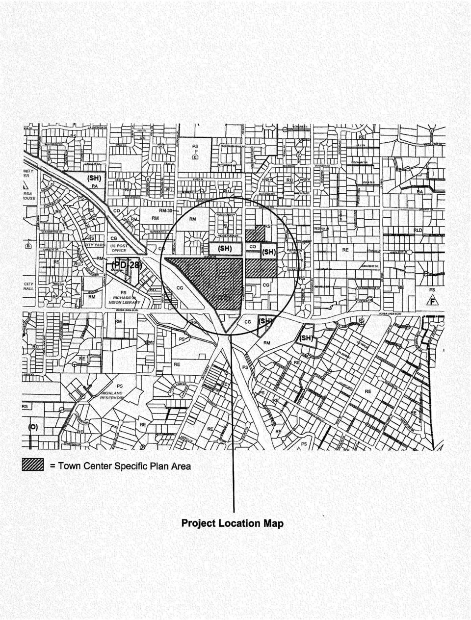
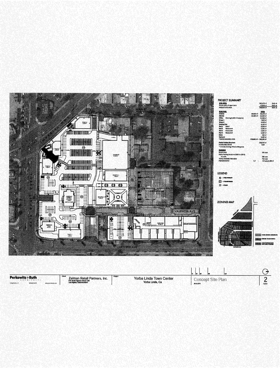
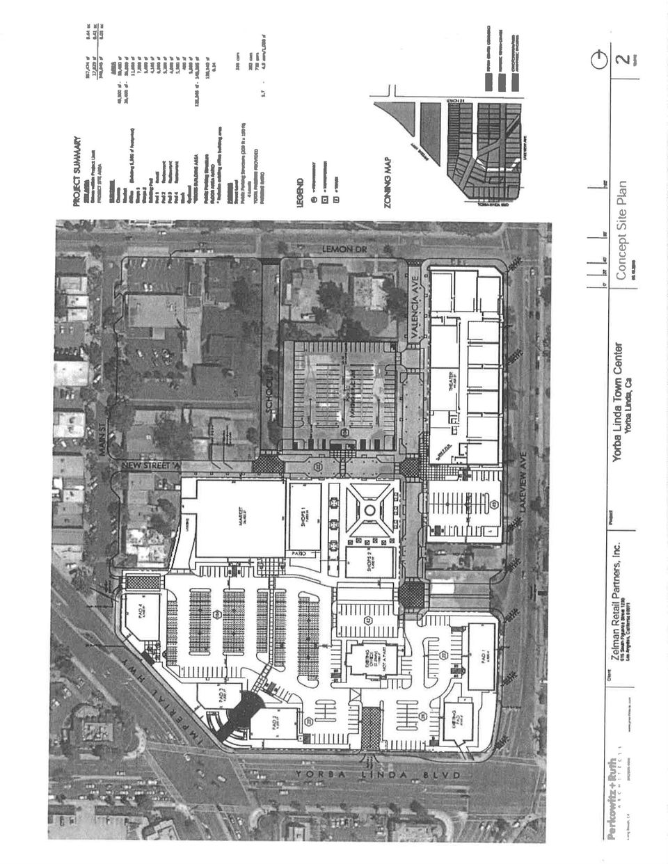
1 Appendix A Request for List of California Native Tribes for Referral of General Plan Amendment Yorba Linda Town Center Subsequent EIR Final Environmental Impact Report Tebo Environmental Consulting, Inc. August 2015

2
3

4
5
6

7

8

9
10
11
12
13

14

15

16

17
18

19
20

21
22
23
24
25
26
27
28
29
30
31 Appendix B Letter from DRC Engineering dated August 11, 2015; Town Center Retail Project Preliminary Storm Water Quality Analysis Yorba Linda Town Center Subsequent EIR Final Environmental Impact Report Tebo Environmental Consulting, Inc. August 2015
32 August 11, 2015 Job No Ms, Susan Tebo Tebo Environmental Consulting RE: Yorba Linda Commons Preliminary Storm Water Quality Analysis Dear Susan: I have listed below our preliminary findings for your use regarding the storm water for the project The existing site area consists of a combination of commercial and residential land use. The proposed land use is commercial. These land uses were used to determine hydrologic conditions of concern (HCOC) as described in the county s Water Quality Management Plan (WQMP) technical guidance document for north Orange County. The site is soil type D as described in the county s hydrology manual and is mainly clay with poor infiltration properties. The city as part of their road project had a soils report prepared by LOR Geotechnical Group dated July 23, They state in the report that the soils are silty sand and lean clay with sand in an engineered compacted state. In this report infiltration tests were ran and the tests results were infiltration rates of 0.01 and inches per hour. These results are considered poor infiltration rates. DRC ran the existing and proposed 2 year 24 hour storm events based on a project site of 9.17acres. This area included the proposed commercial development, public parking structure and a portion the following public streets Valencia Ave., School St., New Street A. Based on the analysis is has been determined that approximately 0.47ac-ft (20473CF) of storm water will need to be retained. The Landscape Architect has provided DRC with preliminary peak irrigation demand for the project and the estimated peak 6250GPD or 835CFD. Using this data and the required amount of water required to be retained the storage time to use the storm water for irrigation would be approximately 24.5 days. The duration would be in excess of vector control standing water policy and would exceed the storm duration for the next storm event. It is our opinion that reuse is not applicable to this project. Based on the poor infiltration rate and that a majority of the site will be in engineered fill it is our opinion that infiltration and bio retention is not an option. There might be some opportunities to use limited bio-treatment systems that have underdrains and that are lined. The specific plan for the project references that pervious type pavers or pavement should be used on this project. It is our opinion that this option with an underdrain system best fits the development. Please contact me should you have further questions. Sincerely, Gregory R. Cooke PE, PLS
33 Appendix C Letter from Urban Crossroads dated April 30, 2015; Yorba Linda Town Center Shared Parking Analysis Yorba Linda Town Center Subsequent EIR Final Environmental Impact Report Tebo Environmental Consulting, Inc. August 2015
34 April 30, 2015 Mr. Steve Harris City of Yorba Linda 4845 Casa Loma Yorba Linda, CA SUBJECT: YORBA LINDA TOWN CENTER SHARED PARKING ANALYSIS Dear Mr. Steve Harris: The firm of Urban Crossroads, Inc. is pleased to provide this Shared Parking Analysis for the proposed Yorba Linda Town Center ( Town Center Area ), which is located on the northeast corner of Imperial Highway and Yorba Linda Boulevard, in the City of Yorba Linda. The purpose of the Shared Parking Analysis is to determine if the Town Center Area could be parked with surface parking or if a parking structure is necessary in order to accommodate the parking demands. The ability to accurately estimate parking demand and provide adequate parking supply is critical to the success of any development. A lack of adequate parking can result in drivers intruding into adjacent neighborhood or business areas to find parking, adversely affecting the perceived livability of the nearby neighborhoods and reducing the ability of businesses to accommodate customers. A successful development combines sufficient parking opportunities where visitors park once and walk to multiple destinations. Residential development should be self-parked (i.e., provide its own offstreet parking), whereas, businesses should provide the parking required to accommodate their own demand. However, for the business and public facility components within the Town Center Area, the demand should be considered as a whole, rather than as individual developments. The mixed-use nature of the Town Center Area creates a shared parking environment, allowing for fewer spaces to be provided for each individual development to accommodate the demand for the Town Center Area as a whole. SHARED PARKING ANALYSIS As some of the proposed uses have parking demands that peak during different times of the day, there is an opportunity for these uses to share parking with other proposed uses. The Urban Land Institute (ULI) shared parking methodology determines peak parking demand by applying adjustment factors for seasonal, hourly, and weekday versus weekend conditions. The parking demand for a site operating autonomously is reflective of the peak-hour during the peak-month in the year, thus resulting in a worst-case conservative estimate. To accurately estimate the potential peak parking demand and required parking supply it is important to consider several factors such as the proposed land uses, operating characteristics of each land use, Letter REV2.docx
35 Mr. Steve Harris City of Yorba Linda April 30, 2015 Page 2 of 5 the site layout, and pedestrian connectivity. The Town Center Area proposes a wide range of land uses all within a reasonable walking distance of one another, and when combined with improved pedestrian and vehicular connectivity, the opportunity to share parking spaces between various land uses can be achieved. Shared parking is the use of a single parking space to serve two or more individual land uses without conflict or encroachment as described in ULI s Shared Parking, 2nd Edition According to the ULI methodology, the ability to share parking spaces is the result of two conditions: Variations in the accumulation of vehicles by hour, by day, or by season at the individual land uses, and Relationships among the land uses that result in visiting multiple land uses on the same auto trip. Given the mix of land uses currently proposed within the Town Center Area, the aforementioned conditions would likely be met. For example, parking supply needed for office uses during the morning and mid-day hours could be utilized by the restaurant and retail uses in the evening hours and weekends when office use demand is low. Alternatively, a theater patron may decide to stop at one of the restaurants for dinner or shop at a retail store on their way to the theater for the evening or weekend. According to ULI shared parking has been a fundamental principal of downtown planning from the earliest days of the automobile. As shown below on Table 1, the Town Center area, excluding the area east of Lakeview Avenue, currently has a combined 342 off-street and on-street parking spaces provided. It is anticipated that with the development of the proposed Town Center Area, an additional 464 parking spaces would be provided for a total future parking supply of approximately 806 spaces. The traffic analysis zone (TAZ) boundaries utilized for the Town Center Area is shown on Exhibit 1. TABLE 1: EXISTING PARKING SUPPLY INVENTORY District Supply Off-Street On-Street Total TAZ 1: Town Center West Commercial TAZ 2: Historic Town Center Commercial TAZ 3: Public Facilities/Cottage TAZ 4: Town Center East Commercial TOTAL Source: Yorba Linda Town Center Specific Plan Traffic Impact Analysis, November 15, 2010 (Revised), Urban Crossroads, Inc. Table 2 presents the existing and future parking supply, by District. It should be noted that the proposed Zelman Shopping Center is located within portions of TAZ 3 and TAZ 4 of the Specific Plan. The proposed Zelman Shopping Center is shown on Exhibit 2. The number of parking spaces presented in Table 2 was determined based on a conceptual physical layout of existing and future development Letter REV2.docx
36 Mr. Steve Harris City of Yorba Linda April 30, 2015 Page 3 of 5 Actual future development site plans may yield a slight variation on capacity depending on future development within TAZ 1 and TAZ 2. The parking spaces shown for TAZ 3 in Table 2 are the portions of the Public Facilities TAZ that is not included as part of the Zelman Shopping Center. TABLE 2: SUMMARY OF PROPOSED PARKING SPACES District Off-Street Supply On-Street TAZ 1: Town Center West Commercial TAZ 2: Historic Town Center Commercial TAZ 3: Public Facilities Subtotal TAZ 3/TAZ 4: Zelman Shopping Center TOTAL Table 3 lists the proposed land uses and intensities assumed for the purposes of the shared parking analysis. The proposed land uses within TAZ 1 and TAZ 2 are consistent with the Yorba Linda Town Center Specific Plan Traffic Impact Analysis, while the shopping center use and square footage identified for the Zelman Shopping Center is based on the currently proposed plan (see Exhibit 2). TABLE 3: SUMMARY OF LAND USES CONSIDERED FOR SHARED PARKING TAZ Land Use Quantity Restaurant 6,000 square feet 1 General Office 6,500 square feet Single Family Detached 1 1 dwelling unit Commercial Retail square feet Commercial Retail 30,384 square feet General Office 11,200 square feet 2 Bank with Drive-Thru Window 6,800 square feet Restaurant 8,000 square feet Condo/Townhouse 1 10 dwelling units 3 Fire Station 2 9,000 square feet Church 2 22,000 square feet 4 Zelman Shopping Center 125,605 square feet 1 Residential uses have not been included as part of shared parking evaluation as the parking for these uses are considered private. 2 The fire station and church uses have also not been included as part of the shared parking evaluation as the parking for these uses are considered private. For the proposed Town Center Area, standard parking requirements based on the Yorba Linda Town Center Specific Plan have been calculated, along with an analysis of the benefits of shared parking for the mix of uses proposed within the Town Center Area based on ULI s Shared Parking methodology, which takes into consideration time of day factors, mode adjustment, and modal split for each land Total Letter REV2.docx
37 Mr. Steve Harris City of Yorba Linda April 30, 2015 Page 4 of 5 use. Each of these factors is incorporated into spreadsheets, and applied to the specific mix of uses associated with the Town Center Area. Applying these factors to a particular mix of integrated land uses yields a peak parking requirement at a particular time of day (weekday and weekend) and season. The total peak parking demand for the mix of uses will be less than the sum of the full parking requirement for each use, due to interrelationships and benefits of shared parking. FINDINGS The ULI methodology indicates that 1,122 parking spaces are needed to support the Town Center Area during the weekday and 1,039 parking spaces to accommodate the weekend demand (see attached Table 5). Of these spaces, 628 spaces are required to accommodate the Zelman Shopping Center parking needs, which is assumed to be parked at 5 spaces per 1,000 square feet of shopping center use. It is our understanding that the Zelman Shopping Center will accommodate the 628 parking spaces through a combination of on-site surface parking, valet parking services, and off-site remote parking to meet the parking demand. As such, there is a remaining parking demand of 494 spaces during the weekday and 423 spaces during the weekend to serve the remainder of the Town Center Area. Based on the summary of proposed parking spaces provided on Table 2, there are approximately 178 parking spaces remaining within TAZs 1 through 3. The existing and future proposed parking supply of 178 parking spaces would not adequately meet the parking needs for the remaining uses within the Town Center Area. As such, additional parking strategies would need to be implemented in conjunction with the reduced parking ratios to address the parking supply deficiency of 316 spaces during the weekday and 245 spaces during the weekend. Additional public parking necessary to accommodate the parking needs of the Town Center Area could be accomplished through the construction of an on-site public parking structure. Table 4 summarizes the parking requirements and deficiency. TABLE 4: PARKING REQUIREMENTS Existing and Future Parking Proposed Town Center Area Parking Requirement 1,2 Net Difference 3 TAZ Supply Weekday Weekend Weekday Weekend TAZ 1, TAZ 2, and TAZ Does not include the Zelman Shopping Center. 2 Based on the ULI Shared Parking Methodology, 2nd Edition (2005). 3 Negative number represents a deficiency Letter REV2.docx
38 Mr. Steve Harris City of Yorba Linda April 30, 2015 Page 5 of 5 If you have any questions, please contact me directly at (949) URBAN CROSSROADS, INC. Aric Evatt, PTP Principal Charlene So, PE Senior Transportation Engineer Attachment Letter REV2.docx
39
40
41 Table 5 Parking Requirements Specific Plan ULI Weekday ULI Weekend Recommended Parking PROJECT Parking Shared Parking Shared Parking Spaces LAND USE Quantity Units 1 Requirements 2 Demand 3,4 Demand 3,5 Weekday 6 Weekend 7 Zelman Shopping Center 125,605 sf Retail/Commercial 50,800 sf Restaurant Uses 14,000 sf General Office 17,700 sf Bank with Drive thru 6,800 sf Residential 8 11 du Church seats Total Parking Spaces Required ,122 1,039 Total Parking Spaces Required (less Zelman Shopping Center) sf = Square Feet; du = Dwelling Units 2 Rates are per the Yorba Linda Town Center Specific Plan. 3 Rates are based on the ULI Shared Parking Methodology, 2nd Edition (2005). 4 Peak weekday demand is during the month of December at 1 PM. 5 Peak weekend demand is during the month of December at 12 PM. 6 Rates are based on the ULI Shared Parking Methodology, 2nd Edition (2005), with the exception of the Zelman Shopping Center use which h utilizes the Specific Plan's recommended d 5 spaces per 1,000 square feet. 7 Consistent with the ULI Shared Parking methdology, weekend parking demand for the Zelman Shopping Center use was determined based on the weekend parking demand being approximately 98% of the weekday demand. 8 Parking needs determined based on Specific Plan parking code as stand alone uses (i.e., not included as part of the shared parking analysis). NOM = Nominal (Less than 2 spaces required)
42 Appendix D ICU Intersection Analysis Worksheets (Tables 1, 2, and 3 from Urban Crossroads Letter dated August 15, 2015) Yorba Linda Town Center Subsequent EIR Final Environmental Impact Report Tebo Environmental Consulting, Inc. August 2015
43 Table 1 Intersection Analysis for Existing plus Project Conditions Existing (2014) Existing Plus Project Change in Traffic ICU (v/c) 1 ICU (v/c) 1 v/c # Intersection Control 2 AM PM AM PM AM PM AM PM AM PM Significant? 31 Imperial Hwy. (SR 90) / Orangethorpe Av. Ramp TS A A A A No 32 Imperial Hwy. (SR 90) Ramp / Orangethorpe Av. TS C C A A No 33 Imperial Hwy. (SR 90) / E. La Palma Av. TS C D C D No 1 2 ICU reported as a volume to capacity ratio. Level of service calculated using Traffix, Version 8.0 R1 (2008). TS = Traffic Signal
44 Table 2 Intersection Analysis for Opening Year Cumulative (2016) Conditions 2016 Without Project 2016 With Project Change in Traffic ICU (v/c) 1 ICU (v/c) 1 v/c # Intersection Control 2 AM PM AM PM AM PM AM PM AM PM Significant? 31 Imperial Hwy. (SR 90) / Orangethorpe Av. Ramp TS A A A A No 32 Imperial Hwy. (SR 90) Ramp / Orangethorpe Av. TS A A A A No 33 Imperial Hwy. (SR 90) / E. La Palma Av. TS C D D D No 1 2 ICU reported as a volume to capacity ratio. Level of service calculated using Traffix, Version 8.0 R1 (2008). TS = Traffic Signal
45 Table 3 Intersection Analysis for Horizon Year (2035) Conditions Traffic ICU (v/c) 1 ICU (v/c) 1 v/c # Intersection Control 2 AM PM AM PM AM PM AM PM AM PM Significant? 31 Imperial Hwy. (SR 90) / Orangethorpe Av. Ramp TS B A B A No 32 Imperial Hwy. (SR 90) Ramp / Orangethorpe Av. TS B B B B No 33 Imperial Hwy. (SR 90) / E. La Palma Av. TS D F D F No * BOLD = LOS does not meet the applicable jurisdictional requirements (i.e., unacceptable LOS). 1 2 ICU reported as a volume to capacity ratio. Level of service calculated using Traffix, Version 8.0 R1 (2008). TS = Traffic Signal 2035 Without Project 2035 With Project Change in
9988 REDWOOD AVENUE PROJECT TRAFFIC IMPACT ANALYSIS. April 24, 2015
 9988 REDWOOD AVENUE PROJECT TRAFFIC IMPACT ANALYSIS April 24, 2015 Kunzman Associates, Inc. 9988 REDWOOD AVENUE PROJECT TRAFFIC IMPACT ANALYSIS April 24, 2015 Prepared by: Bryan Crawford Carl Ballard,
GLEN ISLE MIXED USE DEVELOPMENT GLEN COVE, NEW YORK
 SHARED PARKING ANALYSIS GLEN ISLE MIXED USE DEVELOPMENT Prepared for: REXCORP-GLEN ISLE PARTNERS, LLC JULY 27, 2011 WALKER PARKING CONSULTANTS 50 West 23 rd Street, Suite 704 New York, NY 10010 Voice:
Table of Contents B.2 Traffic/Access - Parking
 Table of Contents B.2 Traffic/Access - Parking 1. INTRODUCTION... 940 2. ENVIRONMENTAL SETTING... 940 a. Existing Parking Regulations and Requirements... 940 b. Parking Supply Baseline Conditions... 941
APPENDIX J TRAFFIC STUDY
 APPENDIX J TRAFFIC STUDY May 7, 2014 Ms. Leianne Humble Denise Duffy and Associates, Inc. 947 Cass Street, Suite 5 Monterey, CA 93940 Re: Traffic Study for the Heritage Oaks Memorial Park in San Jose,
HIGHLANDS NEIGHBORHOOD STUDY AREA PARKING ANALYSIS
 HIGHLANDS NEIGHBORHOOD STUDY AREA PARKING ANALYSIS Prepared for: City and County of Denver Department of Public Works, Engineering Division Traffic Engineering Services Parking Operations 201 W. Colfax
TRANSPORTATION IMPACT ANALYSIS PROCEDURES MANUAL
 TRANSPORTATION IMPACT ANALYSIS PROCEDURES MANUAL INTRODUCTION The Town of Harrisburg is committed to establishing an interconnected, multimodal transportation system that increases mobility, safety, connectivity,
BLOCK 400 PLANNED COMMUNITY DISTRICT
 BLOCK 400 PLANNED COMMUNITY DISTRICT Newport Center December 1983 Newport Beach, California Ordinance 88-119 Adopted December 12, 1988 Amendment No. 672 Resolution No. 95-115 Adopted October 9, 1995 Amendment
Appendix J Santa Monica Travel Demand Forecasting Model Trip Generation Rates
 Appendix J Santa Monica Travel Demand Forecasting Model Trip Generation Rates SANTA MONICA TRAVEL DEMAND FORECASTING MODEL TRIP GENERATION RATES SUBMITTED BY: 201 Santa Monica Blvd., Suite 500 Santa Monica,
DRAFT Policy to Guide Discretion on Proposed Relaxations to Minimum Parking Requirements in Commercial Districts City-Wide 2014 June 05
 PARKING INITIATIVES Attachment I Corridor Program Descriptions Corridor Program Pilot Though the Corridor Program will officially launch in the fall, this summer, The City will pilot the first phase of
TRAFFIC IMPACT ANALYSIS HANDBOOK VOLUME I METHODOLOGIES & REQUIREMENTS
 TRAFFIC IMPACT ANALYSIS HANDBOOK VOLUME I METHODOLOGIES & REQUIREMENTS Downtown panoramic photo provided by 1stACT Silicon Valley (blank below this line) Volume I Methodologies and Requirements TABLE OF
TRAFFIC IMPACT ANALYSIS
 TRAFFIC IMPACT ANALYSIS Presenter Gerry Harter, PE, Area Traffic Engineer Acting Transportation and Land Use Director Why a TIA? Roads are a critical public resource and a major investment of public funds
4.5 TRANSPORTATION - YEAR 2025 TRAFFIC CONDITIONS WITH PROPOSED TIMP 4.5-1 ESTIMATION OF TRIP REDUCTIONS WITH TIMP TRANSIT AND TDM PROGRAMS
 Draft Environmental Impact Report State Clearinghouse No. 2002061090 City of LA EIR No. 2003-1922-EIR CPC No. 98-0010 (CPU) 4.5 TRANSPORTATION - YEAR 2025 TRAFFIC CONDITIONS WITH PROPOSED TIMP This chapter
SOLD. Lot 1. 1 Mile: Population: 10,200 Median HH Income: $33,100. 3 Mile: Population: 80,200 Median HH Income: $34,900
 Walmart Outparcels For Sale College Station, TX Store # 1150 1815 Brothers Blvd FM 2818 W SOLD Texas Ave S/ Hwy 6 Longmire Dr Brothers Blvd Lot 1 For more information about this site, contact: Lot 1: ±2.41
NOTICE OF PREPARATION
 PLANNING DIVISION CITY OF SUNNYVALE P.O. BOX 3707 SUNNYVALE, CA 94088-3707 NOTICE OF PREPARATION TO: Responsible, Trustee, and Other Interested Public Agencies FROM: Sunnyvale Community Development 456
Staff Report General Development Plan/Master Plan Aldermanic District: 1 County Commission District: 2 MPC File No. 16-000526-PLAN February 23, 2016
 Staff Report General Development Plan/Master Plan Aldermanic District: 1 County Commission District: 2 MPC File No. 16-000526-PLAN February 23, 2016 1101 Bull Street One West Park Avenue 1107 Bull Street
CITY COUNCIL / PLANNING COMMISSION JOINT STUDY SESSION AGENDA REPORT
 CITY COUNCIL / PLANNING COMMISSION JOINT STUDY SESSION AGENDA REPORT MEETING DATE: SEPTEMBER 8, 2015 ITEM NUMBER: 1 SUBJECT: PROPOSED GENERAL PLAN LAND USE ALTERNATIVE FOR THE YEAR 2015-2025 GENERAL PLAN
EL TORO HIGH SCHOOL BLEACHER AND LIGHTING IMPROVEMENT PROJECT PARKING/TRAFFIC MANAGEMENT PLAN. July 12, 2013
 EL TORO HIGH SCHOOL BLEACHER AND LIGHTING IMPROVEMENT PROJECT PARKING/TRAFFIC MANAGEMENT PLAN July 12, 2013 Kunzman Associates, Inc. EL TORO HIGH SCHOOL BLEACHER AND LIGHTING IMPROVEMENT PROJECT PARKING/TRAFFIC
May 18, 2015. Ms. Courtney O'Neill Associate Planner City of Margate 5790 Margate Blvd. Margate, Florida 33063
 May 18, 2015 Ms. Courtney O'Neill Associate Planner City of Margate 5790 Margate Blvd. Margate, Florida 33063 Re: Atlantic Margate Medical Center 6101 W. Atlantic Blvd. and 513 Melaleuca Drive Margate,
Advantages and Disadvantages of One Way Streets October 30, 2007
 Advantages and Disadvantages of One Way Streets October 30, 2007 0 P age Background As the revitalization of the Central Waterfront area moves forward, one issue that might need closer analysis is the
STAFF REPORT. December 20, 2004. North District Community Council. Director of Community Planning - North
 STAFF REPORT December 20, 2004 To: From: Subject: North District Community Council Director of Community Planning - North Preliminary Report Respecting Revised Application OPA & Rezoning Application 01
Welcome Welcome to the public exhibition for development at Bowman Field. This exhibition provides an overview of the proposals for the site.
 Welcome Welcome to the public exhibition for development at Bowman Field. This exhibition provides an overview of the proposals for the site. Background & Planning Context The Site The site is an area
A. Major Amendment to PUD regarding Restaurants Location: The Shops at West End Applicant: AD West End LLC Case No.: 13-27-PUD STUDY SESSION
 AGENDA PLANNING COMMISSION COUNCIL CHAMBERS 6:00 P.M. JULY 17, 2013 1. Call to order Roll Call 2. Approval of Minutes of June 26, 2013 3. Hearings A. Major Amendment to PUD regarding Restaurants Location:
Restoration. a brief look at
 Copyright 2009 Canin Associates, Inc. All rights reserved. No part of this publication may be reproduced or transmitted by any means without written permission from Canin Associates, Inc. a brief look
The Metropolitan Planning Commission. DATE: May 19, 2015
 TO: FROM: The Metropolitan Planning Commission MPC Staff DATE: May 19, 2015 SUBJECT: Petition of LLC, Owner Harold Yellin, Agent PIN: 2-0015-01-002 & 003 Lot Size:.85 Acres (approximately) Aldermanic District:
Economic Development Element
 The Strawberry Ladies by Tara Stood Economic Development Element Economic development enhances San Clemente s quality of life by providing local goods and services and expanding employment and business
Traffic Impact Study for the 3817-45 North Broadway Mixed-Use Development Chicago, Illinois. Prepared by
 Traffic Impact Study for the Chicago, Illinois repared by March 30, 2015 1. Introduction This report summarizes the methodologies, results and findings of a traffic impact study conducted by Kenig, Lindgren,
1. REPORT CONTEXT Description of the development (include all of the following that are known at the time of the application):
:") Transportation Assessment and Management Study Guidelines for Consultants INTRODUCTION This document is intended to provide guidelines for transportation consultants who produce Transportation reports
Transportation Assessment and Management Study Guidelines for Consultants INTRODUCTION This document is intended to provide guidelines for transportation consultants who produce Transportation reports
AVALON PARK WEST (FORMERLY NEW RIVER) PD/MPUD- NARRATIVE FOR DRI RESCISSION, PD SUBAREA AMENDMENT AND MPUD SUBSTANTIAL MODIFICATION.
 PD/MPUD- NARRATIVE FOR DRI RESCISSION, PD SUBAREA AMENDMENT AND MPUD SUBSTANTIAL MODIFICATION.") AVALON PARK WEST (FORMERLY NEW RIVER) PD/MPUD- NARRATIVE FOR DRI RESCISSION, PD SUBAREA AMENDMENT AND MPUD SUBSTANTIAL MODIFICATION DRI Rescission On January 7, 1992, the Pasco County Board of County Commissioners
AVALON PARK WEST (FORMERLY NEW RIVER) PD/MPUD- NARRATIVE FOR DRI RESCISSION, PD SUBAREA AMENDMENT AND MPUD SUBSTANTIAL MODIFICATION DRI Rescission On January 7, 1992, the Pasco County Board of County Commissioners
How To Build A City Of Virginia Beach Arena
 City of Virginia Beach Arena Infrastructure Preliminary Conceptual Cost Estimates Doug Smith, Deputy City Manager Carl Tewksbury, Kimley-Horn City Council Briefing July 8, 2014 July 8, 2014 Presentation
Transportation Impact Assessment Guidelines
 Transportation Impact Assessment Guidelines Preface The following TIA Guidelines have been developed jointly by the City s Planning and Growth Management and Public Works and Services departments in an
Narrative Response/Attachment 1 (WisDOT 2014-2018 TAP- Second Round Application ID-SWBP22)
") Narrative Response/Attachment 1 (WisDOT 2014-2018 TAP- Second Round Application ID-SWBP22) 2. For Bicycle and Pedestrian Projects: Clearly indicate the location, length, width, surface materials, and any
Narrative Response/Attachment 1 (WisDOT 2014-2018 TAP- Second Round Application ID-SWBP22) 2. For Bicycle and Pedestrian Projects: Clearly indicate the location, length, width, surface materials, and any
Cherokee County: Bells Ferry LCI Study & County Ordinance Audit. Prepared by Atlanta Regional Commission Staff 2006. Atlanta Regional Commission
 Cherokee County: Bells Ferry LCI Study & County Ordinance Audit Prepared by Atlanta Regional Commission Staff 2006 Atlanta Regional Commission 1 Document Review and Recommendations Introduction The objective
Stormwater Design Guidelines Frequently Asked Questions:
 525 Golden Gate, 11th Floor San Francisco, CA 94102 T 415.551.4694 F 415.934.5728 TTY 415.554.3488 Stormwater Design Guidelines Frequently Asked Questions: A. GENERAL INQUIRIES... 2 1. What projects are
Supplemental Plan Check Corrections Sheet for Bicycle Parking Ordinance (Effective 3/13/2013)
") Supplemental Plan Check Corrections Sheet for Bicycle Parking Ordinance (Effective 3/13/2013) Plan Check PCIS application number: - - Job Address Zone: P.C. Engineer (E-mail: firstname.lastname@lacity.org)
Supplemental Plan Check Corrections Sheet for Bicycle Parking Ordinance (Effective 3/13/2013) Plan Check PCIS application number: - - Job Address Zone: P.C. Engineer (E-mail: firstname.lastname@lacity.org)
Design Criteria & Service Goals
 4.1 Design Life of Improvements The design life of a water system component is sometimes referred to as its useful life or service life. The selection of a design life is a matter of judgment based on
In 2012 the commercial sector natural gas demand was 201 billion cubic feet (bcf) or 2.01e + 23 thousand British thermal units (kbtu).
 or 2.01e + 23 thousand British thermal units (kbtu).") ENVIRONMENTAL SETTING The Southern California Gas Company (SoCalGas) provides natural gas to the City of Malibu. The City lies within the boundaries of the South Coastal distribution division. SoCalGas
ENVIRONMENTAL SETTING The Southern California Gas Company (SoCalGas) provides natural gas to the City of Malibu. The City lies within the boundaries of the South Coastal distribution division. SoCalGas
315 First Ave NE Minneapolis, MN 55413
 View Neighborhood View Project Details 315 First Ave NE Minneapolis, MN 55413 22,000 SF of Retail and Restaurant Space Available for Lease View Renderings View Maps View Area Plans Contact NORTHEAST MINNEAPOLIS
BASSETT CREEK VALLEY MASTER PLAN OPEN HOUSE
 BASSETT CREEK VALLEY MASTER PLAN OPEN HOUSE February 23, 2006 PROJECT INTRODUCTION Project Area 230 acres $50 million estimated market value (approximately) 50 acres parkland 100 residences (estimated)
CONCEPT PLAN APPLICATION
 TOWN OF CHAPEL HILL CONCEPT PLAN APPLICATION Applicant Information Name: Jack L. Smyre, The Design Response, Inc. Address: 1014 High House Road, Suite 100 City: Cary State: North Carolina Zip: 27513 Phone
Bed & Breakfast Facilities Criteria. / Questionnaire. Definition (per Section 56.10): SECTION 56.20 - CONDITIONAL USE:
: SECTION 56.20 - CONDITIONAL USE:") Bed Bed & Breakfast Facilities Criteria / Questionnaire The intent of the Hood river County Zoning Ordinance Article 56 and Breakfast Facilities is to protect the character of single family residential
Bed Bed & Breakfast Facilities Criteria / Questionnaire The intent of the Hood river County Zoning Ordinance Article 56 and Breakfast Facilities is to protect the character of single family residential
CALIFORNIA ENVIRONMENTAL QUALITY ACT FINDINGS AND APPROVAL OF THE DESIGN OF THE GENOME LAUNCH FACILITY PROJECT, DAVIS CAMPUS
 CALIFORNIA ENVIRONMENTAL QUALITY ACT FINDINGS AND APPROVAL OF THE DESIGN OF THE GENOME LAUNCH FACILITY PROJECT, DAVIS CAMPUS I. ADOPTION OF THE MITIGATED NEGATIVE DECLARATION Pursuant to Title 14, California
NOTICE OF A TYPE Ix DECISION ON A PROPOSAL IN YOUR NEIGHBORHOOD
 Date: June 29, 2016 To: From: Interested Person Susan Ellis, Land Use Services 503-823-5361 / susan.ellis@portlandoregon.gov NOTICE OF A TYPE Ix DECISION ON A PROPOSAL IN YOUR NEIGHBORHOOD The Bureau of
Lincoln Downtown Master Plan Update
 Lincoln Downtown Master Plan Update Table of Contents Executive Summary........................................... 1 Complete Streets Framework.................................... 3 Promenade Creating
INTRODUCTION TO ZONING DISTRICT REGULATIONS
 INTRODUCTION TO ZONING DISTRICT REGULATIONS Classification of Zoning Districts Zoning districts in Dorchester County are categorized as Suburban Urban, Suburban Transition, or Rural. These districts are
Motorcycle & Pedestrian Master Plans in Indianapolis, Indiana
 PROJECT PURPOSE The Warsaw + Winona Lake Bicycle and Pedestrian Master Plan establishes a comprehensive framework for a connected bicycle and pedestrian system that will be used for both recreation and
SECTION 5.15 ELECTRICITY AND NATURAL GAS
 SECTION 5.15 ELECTRICITY AND NATURAL GAS 5.15 ELECTRICITY AND NATURAL GAS This section addresses the potential impacts of the proposed project with regard to electricity and natural gas consumption. The
Guidelines for the Preparation of Transportation Impact Studies 8 th Revision
 Guidelines for the Preparation of Transportation Impact Studies 8 th Revision Halifax Regional Municipality Traffic and Right of Way Transportation and Public Works P.O. Box 1749 Halifax, Nova Scotia B3J
Downtown Tampa Transportation Vision
 Downtown Tampa Transportation Vision Executive Summary August 1, 2006 Hillsborough County Metropolitan Planning Organization County Center, 18 th Floor Tampa, Florida 33602 813-272-5940 www.hillsboroughmpo.org
CITY OF ESCONDIDO Planning Division 201 North Broadway Escondido, CA 92025-2798 (760) 839-4671 Fax: (760) 839-4313 ARTS AND CRAFTS SHOW PERMIT
 839-4671 Fax: (760) 839-4313 ARTS AND CRAFTS SHOW PERMIT") CITY OF ESCONDIDO Planning Division 201 North Broadway Escondido, CA 92025-2798 (760) 839-4671 Fax: (760) 839-4313 ARTS AND CRAFTS SHOW PERMIT APPLICANT/CONTACT PERSON Name (Print): Address: City, State,
CITY OF ESCONDIDO Planning Division 201 North Broadway Escondido, CA 92025-2798 (760) 839-4671 Fax: (760) 839-4313 ARTS AND CRAFTS SHOW PERMIT APPLICANT/CONTACT PERSON Name (Print): Address: City, State,
Executive Director s Recommendation Commission Meeting: March 5, 2015
 Executive Director s Recommendation Commission Meeting: March 5, 2015 PROJECT Curseen-Morris Processing and Distribution Center Parking Lot 900 Brentwood Avenue NE Washington, DC SUBMITTED BY United States
COUNTY OF ALBEMARLE PLANNING STAFF REPORT SUMMARY. Staff: Claudette Grant
 COUNTY OF ALBEMARLE PLANNING STAFF REPORT SUMMARY Project Name: ZMA 2013-00004 Hollymead Town Center Block VI Planning Commission Public Hearing: July 29, 2014 Staff: Claudette Grant Board of Supervisors
D3 April 8, 2015 Public Hearing
 D3 April 8, 2015 Public Hearing APPLICANT AND PROPERTY OWNER: ASSEMBLY OF YAH, INC. STAFF PLANNER: Kevin Kemp REQUEST: Conditional Use Permit (Religious Facility - church) ADDRESS / DESCRIPTION: 5151 Locke
Preliminary Plan Application and Checklist
 ALL APPLICATIONS ARE DUE AT 12:00 NOON ON THE FILING DATE Office Use Only PRELIMINARY / REVISED PRELIMINARY PLAN $300.00 Fee Paid: $ Date Paid: ALL FIELDS HIGHLIGHTED IN RED ARE REQUIRED FIELDS Case No.:
CALIFORNIA AMERICAN WATER LOS ANGELES DISTRICT 2009 GENERAL RATE CASE CHAPTER: 1 INTRODUCTION AND SUMMARY OF APPLICATION
 DISCUSSION OF INFORMATION PRESENTED IN THIS CHAPTER This chapter contains information regarding the operation of the Los Angeles District of California American Water as well as tables that summarize the
TRANSPORTATION SERVICE STANDARDS ELEMENT GOALS, OBJECTIVES & POLICIES
 TRANSPORTATION SERVICE STANDARDS ELEMENT GOALS, OBJECTIVES & POLICIES Background One of the most critical public services provided by a community is the community s transportation system. An effective
DIVISION STREET CORRIDOR STRATEGY Arlington, Texas May 17, 2012
 DIVISION STREET CORRIDOR STRATEGY Arlington, Texas May 17, 2012 Project Review: DCAC Meeting #2 March 8, 2012 Reviewed stakeholder meetings Online survey findings Market Assessment Macro Market Factors,
SECTION ONE CHAPTER 2: A LAND USE PROFILE OF MANCHESTER
 SECTION ONE CHAPTER 2: A LAND USE PROFILE OF MANCHESTER Land use is the central element of a comprehensive plan because it establishes the overall physical configuration of the city, including the mix
ELEMENT 4 - FUTURE LAND USE ELEMENT
 ELEMENT 4 - FUTURE LAND USE ELEMENT Goal 1 To create a long-range development pattern which directs growth into developable areas and away from environmentally sensitive areas, in a manner that is compatible
GTA Cordon Count Program
 Transportation Trends 2001-2011 Executive Summary Project No. TR12 0722 September 2013 1.0 Introduction The Cordon Count program was established to collect traffic data as a tool for measuring travel trends
Chapter 7 ZONING PLAN
 Chapter 7 ZONING PLAN Introduction This Chapter opens with a general description of a zoning plan. It is followed by a brief explanation of the relationship between this Growth Management Plan and the
C.3 Workshop Track 2: Sizing Calculations and Design Considerations for LID Treatment Measures
 C.3 Workshop Track 2: Sizing Calculations and Design Considerations for LID Treatment Measures Jill Bicknell, P.E., EOA, Inc. Santa Clara Valley Urban Runoff Pollution Prevention Program Presentation Overview
Appendix E Traffic Impact Analysis
 Appendix E Traffic Impact Analysis 2010 Facility Master Plan Factoria Recycling and Transfer Station November 2010 2010 Facility Master Plan Factoria Recycling and Transfer Station November 2010 Department
Fiscal impact analysis of three development scenarios in Nashville-Davidson County, TN
 Fiscal impact analysis of three development scenarios in Nashville-Davidson County, TN April 2013 Prepared by 1 SUMMARY BY SMART GROWTH AMERICA Summary This study examines the relative fiscal costs and
Date 1/2/2014. Prepared for. Virginia Land Investments 10001 Patterson Ave., Suite 200 Richmond, VA 23238. Cleveland, Ohio. Richmond, Virginia
 Date 1/2/2014 The Economic and Fiscal Impact of Carmel Church Station on Virginia The completed Carmel Church Station development is expected to support 20,670 jobs and $3.3 billion in annual economic
Goals & Objectives. Chapter 9. Transportation
 Goals & Objectives Chapter 9 Transportation Transportation MISSION STATEMENT: TO PROVIDE A TRANSPORTATION NETWORK CAPABLE OF MOVING PEOPLE AND GOODS EFFICIENTLY AND SAFELY. T he transportation system
FUTURE LAND USE ELEMENT
 GOALS, OBJECTIVES AND POLICIES FUTURE LAND USE ELEMENT GOAL A THE CITY OF FORT WALTON BEACH WILL PLAN FOR AND PROVIDE A HIGH QUALITY OF LIFE TO MEET THE NEEDS OF THE CURRENT AND FUTURE POPULATION, PROVIDING
Economic Impact and Development Analysis. Proposed Sports Entertainment District
 THE LONDON GROUP Economic Impact and Development Analysis Proposed Sports Entertainment District Prepared For: The City of Escondido November 2010 The London Group 2010 Report Prepared by: Gary H. London,
PROFFER STATEMENT REZONING TLZM 2013-0001 LEEGATE November 1, 2013
 PROFFER STATEMENT REZONING TLZM 2013-0001 LEEGATE November 1, 2013 Leegate LLC and Stanley Martin Companies, LLC, owner and applicant, (the Applicant ) of certain property described as Loudoun County Tax
City of Atwater REQUEST FOR PROPOSALS FOR REAL ESTATE SELLING AGENT SERVICES REQUEST FOR QUALIFICATIONS COMMERCIAL REAL ESTATE AGENT
 City of Atwater REQUEST FOR PROPOSALS FOR REAL ESTATE SELLING AGENT SERVICES REQUEST FOR QUALIFICATIONS COMMERCIAL REAL ESTATE AGENT City of Atwater 750 Bellevue Road Atwater, CA 95301 DUE DATE/TIME: Thursday,
Executive Summary. Does a Streetcar Make Sense in Anaheim
 Does a Streetcar Make Sense in Anaheim Streetcar in Portland s Pearl District Anaheim s proposed streetcar compares well with national best practice in Portland, Seattle and Tampa where new streetcars
Mercer County Multi-Modal Transportation Plan Year 2025 Travel Demand Model
 Mercer County Multi-Modal Transportation Plan Year 2025 Travel Demand Model Prepared For West Virginia Department of Transportation Transportation Planning Division Building 5, Room 824 1900 Kanawha Blvd.
Downtown Los Angeles Streetcar Economic Analysis
 Downtown Los Angeles Streetcar Economic Analysis Executive Briefing Prepared for: Los Angeles Streetcar, Inc. 550 S. Hope Street, Ste. 2300 Los Angeles, CA 90071 Prepared by: AECOM 515 S. Flower Street,
Minor Accommodation Planning Review Application
 City of Beverly Hills Planning Division 455 N. Rexford Drive Beverly Hills, CA 90210 Tel. (310) 285 1141 Fax. (310) 858 5966 Planning Review Overview: Minor Accommodation Planning Review Application Before
Residential Development Travel Plan
 Residential Development Travel Plan A Template for Developers Name of Development (Address) Name of Developer (Contact Details) Date of Travel Plan For office use: Planning reference.. /.. /.. Residential
Appendix G.3 Crain & Associates, Peer Review
 Appendix G.3 Crain & Associates, Peer Review Transportation Planning / Traffic Engineering VIA HAND DELIVERED Wendy Lockwood Sirius Environmental 1478 N. Altadena Drive Pasadena, California 91107 Subject:
TOWN OF WHITBY REPORT RECOMMENDATION REPORT
 TOWN OF WHITBY REPORT RECOMMENDATION REPORT REPORT TO: Planning and Development Committee REPORT NO: PL-80-10 DATE OF MEETING: June 14, 2010 FILE NO(S): OPA-2010-W/03 & Z-12-10 PREPARED BY: Planning Department
BULLETIN NO. 6. Car-Share Requirements and Guidelines for Car-Share Spaces ZONING ADMINISTRATOR. 1. Car-share Basics PURPOSE: OVERVIEW:
 Car-Share Requirements and Guidelines for Car-Share Spaces Section 307 of the City Planning Code mandates the Zoning Administrator to issue and adopt such rules, regulations and interpretations as are
CPED STAFF REPORT Prepared for the City Planning Commission
 CPED STAFF REPORT Prepared for the City Planning Commission CPC Agenda Item #1 June 23, 2014 RLS-72 LAND USE APPLICATION SUMMARY Property Location: 222 Hennepin Avenue Project Name: 222 Prepared By: Becca
University Pointe Opportunity Summary. Remaining in Phase I. University Pointe. Hwy. 29 & Brookside Lane Charlotte, NC.
 250,000 Sq. Ft. Walmart Supercenter Anchored Development University Pointe Opportunity Summary Only 6,000 Sq. Ft. Remaining in Phase I University Pointe Hwy. 29 & Brookside Lane Charlotte, NC University
FILE NO.: Z-6915-C. Gamble Road Short-form PCD and Land Alteration Variance Request
 FILE NO.: Z-6915-C NAME: Gamble Road Short-form PCD and Land Alteration Variance Request LOCATION: Located on the Northwest corner of Chenal Parkway and Gamble Road DEVELOPER: Davis Properties P.O. Box
Land Use Element. Introduction 2.3. A Citywide Land Use Policies 2.3. A-1 The Future Land Use Map & the Location of Zones 2.3. A-2 Uses 2.
 Seattle s Comprehensive Plan Toward a Sustainable Seattle 2.1 Land Use Element Table of Contents Introduction 2.3 A Citywide Land Use Policies 2.3 A-1 The Future Land Use Map & the Location of Zones 2.3
Visualizing Urban Parking Supply Ratios
 Visualizing Urban Parking Supply Ratios Congress for the New Urbanism nd Annual Meeting Buffalo, New York June 4-7, 014 ABSTRACT This work illustrates the potential impacts of minimum parking requirements
CITY OF NORMANDY PARK MANHATTAN VILLAGE REDEVELOPMENT AREA STRATEGY AND CONCEPTUAL MASTER PLAN
 CITY OF NORMANDY PARK MANHATTAN VILLAGE REDEVELOPMENT AREA STRATEGY AND CONCEPTUAL MASTER PLAN Project Purpose The City of Normandy Park is studying ways to help property owners in the Manhattan Village
IV. ENVIRONMENTAL IMPACT ANALYSIS L. UTILITIES AND SERVICE SYSTEMS 3. SOLID WASTE AND DISPOSAL
 IV. ENVIRONMENTAL IMPACT ANALYSIS L. UTILITIES AND SERVICE SYSTEMS 3. SOLID WASTE AND DISPOSAL ENVIRONMENTAL SETTING Within the City, solid waste management, including collection and disposal services
Downtown Community Planning Council Meeting offebruary 18, 2015
 - san diego Item #12 DATE ISSUED: ATTENTION: SUBJECT: February 13, 2015 Downtown Community Planning Council Meeting offebruary 18, 2015 Consideration of Support for Grant Applications for the San Diego
Application No.: 14.074 Steve Rush, representing Rocky Mountain Power Rocky Mountain Power Project Location: approximately 1600 N. 6800 E.
 Planning Commission Staff Report Planning and Development Services Croydon Substation Conditional Use Permit Public Meeting August 28, 2014 Application No.: 14.074 Applicant: Steve Rush, representing Rocky
S. BLOCK 68 REDEVELOPMENT PROJECT AREA
 S. BLOCK 68 REDEVELOPMENT PROJECT AREA 1. Revitalization Project Description The Block 68 Redevelopment Project Area is located on the block bounded by 10 th, 11 th, M, and N Streets, and is comprised
Summary and Description of 2014 Enhancements to New Jersey Model Stormwater Control Ordinance for Municipalities
 Summary and Description of 2014 Enhancements to New Jersey Model Stormwater Control Ordinance for Municipalities This document summarizes and provides explanation for the purpose and intent of major recommended
Performance Measures for a Sustainable Transportation Network Pasadena s Approach Frederick C. Dock, Ellen Greenberg, Mark Yamarone
 Performance Measures for a Sustainable Transportation Network Pasadena s Approach Frederick C. Dock, Ellen Greenberg, Mark Yamarone Abstract. As California cities move into the second decade of the 21st
HIGHWAY DEPARTMENT ACCESS AND RIGHT OF WAY WIDTH GUIDELINES
 Approved 6/26/01 HIGHWAY DEPARTMENT ACCESS AND RIGHT OF WAY WIDTH GUIDELINES All new, modified and/or changed use access(es) onto county roads shall be subject to the access and corridor protection guidelines
SUMMARY OF GROWTH & DEVELOPMENT TRENDS For THE CENTRAL AREA OF CHICAGO. The Parking Industry Labor Management Committee (PILMC)
") SUMMARY OF GROWTH & DEVELOPMENT TRENDS For THE CENTRAL AREA OF CHICAGO Prepared for The Parking Industry Labor Management Committee (PILMC) August 7, 2003 Prepared by Metro Transportation Group, Inc. 70
SUMMARY OF GROWTH & DEVELOPMENT TRENDS For THE CENTRAL AREA OF CHICAGO Prepared for The Parking Industry Labor Management Committee (PILMC) August 7, 2003 Prepared by Metro Transportation Group, Inc. 70
District of Columbia Zoning Requirements for Parking Study
 District of Columbia Zoning Requirements for Parking Study Project Review Project Overview Kickoff May 2007 Review of Existing Conditions: Zoning, Reports, Data Review of Best Practices Review of On-Street
 Walkable Communities Florida Department of Transportation State Safety Office Pedestrian and Bicycle Program April 1995 www.dot.state.fl.us/safety Twelve Steps for an Effective Program Page 1 Twelve Steps
Planning and Analysis Tools of Transportation Demand and Investment Development of Formal Transportation Planning Process
 Orf 467 Transportation Systems Analysis Fall 2015/16 Planning and Analysis Tools of Transportation Demand and Investment Development of Formal Transportation Planning Process 23 USC Para 134: Metropolitan
Schenk-Atwood Neighborhood Business District Master Plan
 Schenk-Atwood Neighborhood Business District Master Plan Prepared for the Schenk-Atwood Revitalization Association (SARA) and the City of Madison SCHREIBER/ANDERSON ASSOCIATES, INC. BEST Real Estate Group,
Mid-Coast Corridor Transit Project San Diego, California New Starts Engineering (Rating Assigned November 2015)
") Mid-Coast Corridor Transit Project San Diego, California New Starts Engineering (Rating Assigned November 2015) Summary Description Proposed Project: Light Rail Transit 10.9 Miles, 9 Stations Total Capital
Mid-Coast Corridor Transit Project San Diego, California New Starts Engineering (Rating Assigned November 2015) Summary Description Proposed Project: Light Rail Transit 10.9 Miles, 9 Stations Total Capital
PC 23-11 Nate Lundgren-Auto Repair Business Conditional Use Permit 9/7/11 Applicants
 PC 23-11 Nate Lundgren-Auto Repair Business Conditional Use Permit 9/7/11 Applicants Nate Lundgren Triple K Partnership Mankato 105 LeSueur Ave 320 Mallard Lane Eagle Lake, MN 56024 Mankato MN 560001 Request
WESTFIELD-WASHINGTON ADVISORY PLAN COMMISSION December 7, 2015 1512-SPP-24 & 1512-ODP-24
 Petition Number: Subject Site Address: Petitioner: Request: East side of Oak Road, north of 151 st Street Langston Development Co. Primary Plat and Overall Development Plan amendment review for Mapleridge
Appendix N: Bicycle Parking Ordinance
 Appendix N: Bicycle Parking Ordinance ORDINANCE NO. #1-13. AN ORDINANCE AMENDING CHAPTER 40 OF THE MUNICIPAL CODE OF THE CITY OF DAVIS TO ADD ARTICLE 40.25A ESTABLISHING BICYCLE PARKING STANDARDS WHEREAS,
ASSESSMENT OF LANDCAPE PROVISIONS FOR PROPOSED PLAN CHANGE 1. Inner Business Zone. Outer Business Zone PALMERSTON NORTH CITY COUNCIL
 A division of Hudson Group Ltd ASSESSMENT OF LANDCAPE PROVISIONS FOR PROPOSED PLAN CHANGE 1 Inner Business Zone Outer Business Zone PALMERSTON NORTH CITY COUNCIL 1 2 A division of Hudson Group Ltd Prepared