STAFF REPORT. December 20, North District Community Council. Director of Community Planning - North
|
|
|
- Allison Farmer
- 8 years ago
- Views:
Transcription
1 STAFF REPORT December 20, 2004 To: From: Subject: North District Community Council Director of Community Planning - North Preliminary Report Respecting Revised Application OPA & Rezoning Application NMI 25 OZ (Previously TD CMB ) Applicant: The Cadillac Fairview Corporation Architect: Giannone Associates Architects Inc. 939 Lawrence Avenue East Don Mills Centre Ward 25 - Don Valley West Purpose: To provide preliminary information on a revised proposal submitted by the Cadillac Fairview Corporation concerning the above-noted applications and to seek Community Council's directions on further processing of the applications and on the community consultation process. Financial Implications and Impact Statement: There are no financial implications resulting from the adoption of this report. Recommendations: It is recommended that: (1) staff be directed to schedule a community consultation meeting together with the Ward Councillor and adjacent Ward Councillor. (2) notice for the community consultation meeting be given to landowners and residents within 120 metres of the site.

2 2 (3) notice for the Public Meeting under the Planning Act be given according to the regulations under the Planning Act. Background: In December 2001, Cadillac Fairview Corporation Limited, the owner of the mall, submitted an application to the City to redevelop Don Mills Centre to facilitate a phased buildout of the Don Mills Centre in order to create a new mixed-use centre. The proposal contemplated internal and external renovations to the enclosed mall; the expansion of retail, service and entertainment space; the relocation and reconstruction of a new Don Mills Civitan Arena; hotel space; additional office space and five condominium apartment buildings. The retail concept combined a traditional enclosed mall with open-air urban street style environment. The application required an amendment to the Official Plan and Zoning By-law to permit the heights of the five apartment buildings and to allow the proposed mix of uses. The application did not progress beyond the Preliminary Staff Report (Clause No. 23, Report No. 1) adopted by City Council at its meeting held on February 13, 14 and 15, 2002 and the Cityhosted Community Consultation Meeting subsequently held on June 6, The Preliminary Report identified a number of issues to be resolved with respect to the proposed redevelopment, including the proposed relocation of the arena, traffic impacts and heights in excess of the zoning permissions. Since that time, Cadillac Fairview has teamed with FRAM Building Group and Slokker Canada, a residential builder, in a joint venture, and have submitted a revised application to redevelop the Centre. Comments: Original Proposal The original proposal contemplated an increase in gross floor area (including the arena) from 66,894m2 (720,047sq.ft) to 152,223m2 (1,638,528sq.ft.) spread out over a series of buildings and a private driveway network. The increase in gross floor area yielded a density or floor space index of 1.0. Building heights for the proposed residential buildings ranged from 9 to 16 storeys. For information purposes, the following is a general statistical breakdown of the previous proposal: Retail & Service and Restaurant/Entertainment 67,286m² (724,266 sq.ft.) 44% Office Space 14,777m² (159,059 sq.ft.) 10% Hotel (100 rooms) 5,816m² (62,603 sq.ft.) 4% New Arena 3,530m² (37,996 sq.ft.) 2% Residential (623 units) 60,814m² (654,602 sq.ft.) 40% Total Previous GFA 152,223m²(1,638,528 sq.ft.) 100% Previous proposed density 1.0 FSI

3 3 Current Proposal Generally, the current proposal provides a revised land use mix, site layout, higher built form and higher density than the original submission. Furthermore, the Don Mills Civitan arena no longer forms part of the application. The new scheme yields an overall density of approximately 1.6 FSI of the site (0.4 FSI for the commercial uses and 1.2 FSI for the residential uses). A hierarchy of new private roads are envisioned to provide pedestrian and vehicular circulation through the site with connections from the community. The proposal maintains essentially the same amount of commercial development that currently exists, approximately 52,600m2 (566,350 sq.ft.), of which about 40,875m2 (440,000 sq. ft.) will be retail, with the remainder comprising the existing Royal Bank office building at the corner of Don Mills Road and Lawrence Avenue East. Retail parking will be provided in below grade structures and on existing surface lots located along the Don Mills Road and Lawrence Avenue East frontages. Approximately 2,607 parking spaces will be provided for the retail and commercial and office uses on the site. The revised proposal includes 1,500 dwelling units planned in a series of mid-rise and high-rise buildings. Most of the residential units will be in residential-only buildings along The Donway West, within the south half of the site. Some of the residential units are planned in mixed use buildings that contain retail at grade surrounding a Town Square. Other residential buildings will front onto a new north-south street leading to the square, and may include retail, small office, live-work, or other commercial uses at grade. A portion of the residential units will be designed as seniors housing. The proposed residential buildings will range in height from approximately 7 and 8 storeys along The Donway West and step up to 10, 12, 14, 17 and 20 storeys toward the centre of the site. Parking for the residential units will be provided below grade. Approximately 2,655 parking spaces are provided for the residential uses. The following are pertinent statistics of the current proposal: Site Area 152,539m² (1,641,929 sq.ft.) Existing Gross Floor Area (no residential) 63,515m² (683,675 sq.ft.) Existing Density 0.40 FSI Proposed Gross Floor Area Retail & Service Commercial 40,876m² (439,989 sq.ft.) Office 9,990m² (107,532 sq.ft.) Institutional/Other 1,858m² (19,999 sq.ft.) Residential (1,500 units) 184,540m² (1,986,388 sq.ft.) TOTAL Proposed GFA 237,258m² (2,553,908 sq.ft.) Proposed Density 1.6 FSI Pertinent statistics are set out in Attachment 4, Application Data Sheet.
, of which about 40,875m2 (440,000 sq. ft.")
4 4 Site Description The Don Mills Centre comprises lands bounded by Lawrence Avenue, Don Mills Road, and The Donway West. Within this boundary, the Cadillac Fairview ownership comprises 152,223m2 (15.2ha or 37.7 acres) of site area. The Centre is developed with a 2-storey enclosed shopping mall including: a Dominion Food store; a TD Canada Trust building; a 5-storey office building (Royal Bank) at 1090 Don Mills Road; a 4-storey office building at 49 The Donway West; and until recently a Shell Canada automobile service site at 966 Don Mills Road (at the Donway). Lands within the Centre including the Postal Station building at 169 The Donway West, the 14- storey office building at 75 The Donway West and Don Mills Civitan arena. Land uses surrounding the Centre are predominantly residential. The following is a summary of the area context: East: South/West: North: Nine apartment buildings ranging from 3 ½ to 6-storeys in height; 2-storey townhouses; 4 to 6-storey apartment buildings; a 4-storey office building at 170 The Donway West; Two apartment buildings 3½ to 6-storeys; a public library. Official Plan North York Official Plan The site is identified on Map A.2 Potential Urbanization Areas as a Sub-Centre. Sub Centres are intended to serve as social, community and commercial focal points. They are identified as reurbanization areas where medium and high-density development could be accommodated. Sub-Centres are intended to be mixed-use areas combining compatible residential uses with employment uses, including commercial uses. Part C.10 Section contains specific policies for sub-centres. A wide range of residential uses is permitted including multiple unit housing and high rises. Part C.5 Section 3.0 contains additional policies for Sub-Centres, noting they are intended to be multi-use focal points for the activity of surrounding residential areas and characterized by a concentration of residential, retail and service commercial, and office uses. The Don Mills Centre is within the Residential Community of Don Mills as shown on Map C.1.2 in the North York Official Plan. The Plan designates the Don Mills Centre site as Commercial with a small portion (the arena) designated as Local Open Space (Map C.1). The Part C.5 policies of the Plan contain specific policies for commercial development. The intent of the policies is to preserve the commercial function of commercial areas while permitting complementary uses that enhance the commercial area and make efficient use of lands. Permitted uses in Commercial districts that are within a Residential Community include retail and service commercial; offices; residential on upper floors; and some institutional uses. While residential heights are limited to two storeys and the maximum density is limited to 1.0 FSI, the Official Plan supports additional residential height and additional development density
.")
5 5 in commercial areas, provided that the proposed development meets a set of compatibility criteria found in Part C.5 Section Additional policies for the design and development of retail and service commercial uses (Part C.5 Section 2.8.0) include emphasizing the need to provide adequate pedestrian access, to complement and consolidate existing commercial development, to provide sufficient and convenient parking, and to provide setbacks and landscaping to minimize impacts on adjacent residential areas. Central Don Mills Secondary Plan The Don Mills Centre site is governed by the Central Don Mills Secondary Plan, found in Part D.7 of the Official Plan. The Secondary Plan contains policies that are area-specific and more detailed than those in the general Official Plan. The Secondary Plan sets out policies to guide land use in the area roughly bounded by Leslie Street to the west, York Mills Road to the north, the Don Valley to the east and the CP and CN Rail lines to the south. The site is designated Commercial (COM) which permits office, residential uses and retail and service commercial uses, other than hotels and motels to a maximum density of 1.0 FSI. The Secondary Plan contains specific policies addressing the Don Mills Centre (Section 4.4.0). Policy states that the area is intended to function as the commercial and community centre of the Don Mills Community. Policies in the section provide design and development application guidelines. Design guidelines include matters relating to pedestrian access, exterior building facades, parking structures, landscaping, and the provision of publicly accessible areas for indoor and outdoor activities. The plan also encourages residential uses, particularly in building forms that mix commercial and residential functions. Where residential uses develop, resident parking shall be underground. Policy of the Secondary Plan specifies that taller buildings are to be located along Don Mills Road while lower buildings are to be located along The Donway West. New Toronto Official Plan At its meeting of November 26-28, 2002, City Council adopted the new Official Plan for the City of Toronto. The Minister of Municipal Affairs and Housing approved the new plan, in part, with modifications. The Minister s decision has been has been appealed in its entirety. The Official Plan is now before the Ontario Municipal Board. No hearing date has been set. Once the Plan comes into full force and effect, it will designate the property as Mixed Use. Mixed Use Areas are to consist of a broad range of commercial, residential and institutional uses, as well as parks and open spaces. The current policies of the Central Don Mills Secondary Plan have been carried forward and incorporated into the new Official Plan.

6 6 Zoning The site is zoned C3(8) (Regional Shopping Centre) with a site specific zoning exception. The purpose of the exception is to establish a special parking ratio and establish maximum building heights. The minimum parking requirement is 1,878 spaces for a gross floor area of 63,513m² (683,675 sq.ft.). Beyond that, parking is to be provided on the basis of 1 space per 20m² of gross leasable floor area for retail and service commercial uses and 1 space per 48m² of gross floor area for business and professional offices. These parking rates are similar to both Fairview Mall and Yorkdale Shopping Centre. The by-law limits the height of buildings on the east half of the site to 8 storeys or metres above sea level, whichever is greater. Maximum height on the west half of the site is limited to and metres above sea level. Site Plan Control An application for site plan approval has not been filed. Reasons for the Application An application to amend the Official Plan and zoning by-law is required to permit the proposed density and building heights. Issues to be Resolved Subject to any additional matters that may be raised and identified through the public consultation process, the following issues will need to be addressed. The Secondary Plan and zoning by-law permits up to 8 storeys and a maximum density of 1.0 FSI. The proposal exceeds these limits. The application poses built form issues resulting from the proposed deployment of density on the site including, location and organization of the buildings, height, and amount of open space. A traffic study will need to be submitted to assess transportation and parking impacts associated with this development. Appropriate site plan and built form relationships to the street and adjacent buildings will be reviewed to achieve a safe, comfortable and attractive public realm, minimize negative impacts to nearby properties and achieve good site circulation. Design matters related to the surface parking lots, pedestrian systems, exterior façade treatments, landscape areas and the provision of publicly accessible indoor and outdoor activity areas will be examined to ensure they address Secondary Plan policies.

7 7 The Don Mills Civitan Arena is an integral part of the overall Don Mills Centre and the application will be evaluated to ensure it is appropriately integrated in the new scheme. It is the intent of the policies that the Don Mills Centre function as the commercial and community centre of the Don Mills community. The proposal will be evaluated to ensure the intent of these policies are met. The proposed development involves an increase in height and density therefore appropriate Section 37 benefits will be reviewed as part of the application. Conclusions: A community consultation meeting is to be scheduled by staff, in consultation with the Ward Councillors, where the public can comment on the revised application. A Final Report and the Public Meeting under the Planning Act to consider this application is targeted for the third quarter of 2005, provided that any additional information is provided by the applicant in a timely fashion. Contact: Steve Forrester, Senior Planner Telephone: (416) Fax: (416) sforrest@toronto.ca Thomas C. Keefe Director, Community Planning, North District List of Attachments: Attachment 1: Site Plan Attachment 2: Zoning Attachment 3: Official Plan Attachment 4: Application Data Sheet

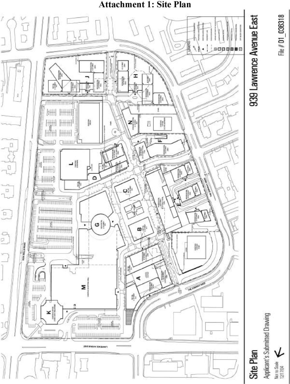
8 Attachment 1: Site Plan
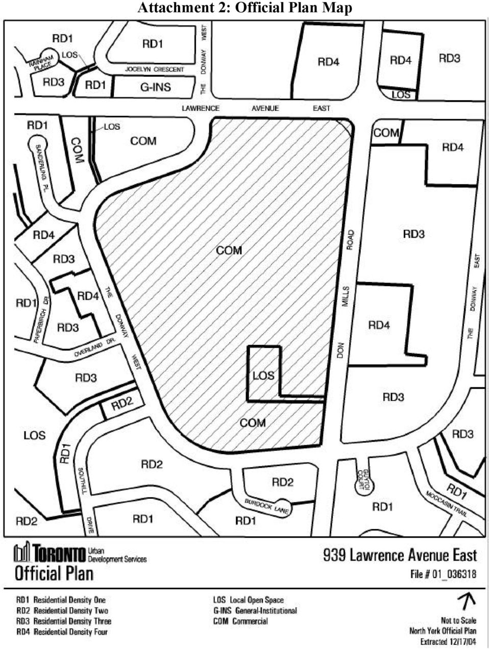
9 Attachment 2: Official Plan Map
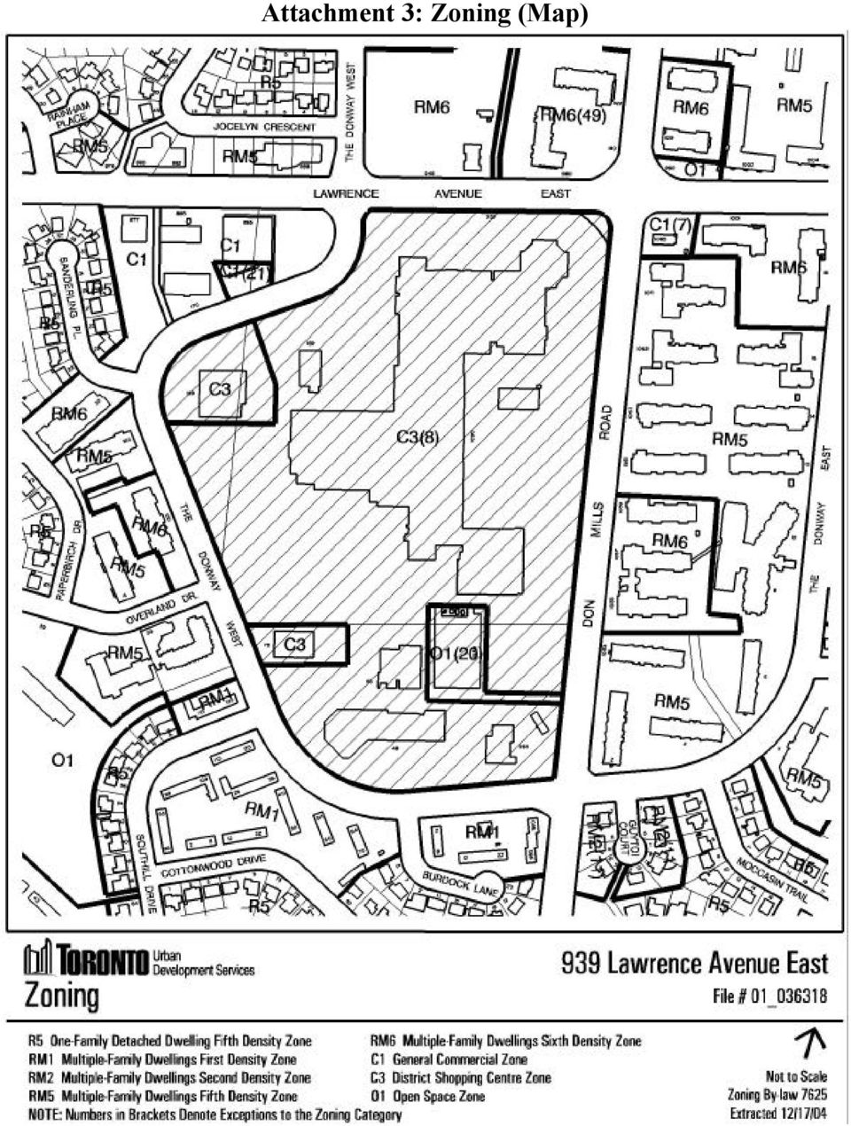
10 Attachment 3: Zoning (Map)
11 APPLICATION DATA SHEET Application Type OPA & Rezoning Amendment Application Number: NMI 25 OZ Details OPA & Rezoning, Standard Application Date: November 14, 2001 Municipal Address: Location Description: Project Description: 939 LAWRENCE AVE E, Toronto ON 939 LAWRENCE AVE E PART OF BLOCKS A AND D, R.P.4545 Proposed Use: Mixed use Applicant: Agent: Architect: Owner: URBAN STRATEGIES PLANNING CONTROLS GIANNONE ASSOCIATES Official Plan Designation: COM Site Specific Provision: Zoning: C3(8) Historical Status: Height Limit (m): 8 storeys Site Plan Control Area: Y PROJECT INFORMATION Site Area (sq. m): Height: Storeys: 20 Frontage (m): 505 Metres: 73 Depth (m): 208 Total Ground Floor Area (sq. m): Total Total Residential GFA (sq. m): Parking Spaces: 5262 Total Non-Residential GFA (sq. m): Loading Docks 0 Total GFA (sq. m): Lot Coverage Ratio (%): Floor Space Index: 1.6 DWELLING UNITS FLOOR AREA BREAKDOWN CADILLAC FAIRVIEW CORPORATION LTD Tenure Type: Condo Above Grade Below Grade Rooms: 0 Residential GFA (sq. m): Bachelor: 0 Retail GFA (sq. m): Bedroom: 0 Office GFA (sq. m): Bedroom: 0 Industrial GFA (sq. m): Bedroom: 0 Institutional/Other GFA (sq. m): Total Units: 1500 CONTACT: PLANNER NAME: Steve Forrester, Senior Planner TELEPHONE: (416)

23 Glen Watford Drive - Zoning Amendment Application - Preliminary Report
 STAFF REPORT ACTION REQUIRED 23 Glen Watford Drive - Zoning Amendment Application - Preliminary Report Date: August 21, 2013 To: From: Wards: Reference Number: Scarborough Community Council Director, Community
3655 Kingston Rd - Official Plan and Zoning By-law Amendment Applications - Preliminary Report
 STAFF REPORT ACTION REQUIRED 3655 Kingston Rd - Official Plan and Zoning By-law Amendment Applications - Preliminary Report Date: January 13, 2016 To: From: Wards: Reference Number: Scarborough Community
Toronto and East York Community Council. Director, Community Planning, Toronto and East York District. 15-236743 STE 14 OZ and 15-130397 STE 14 RH
 STAFF REPORT ACTION REQUIRED 56-58 Atlantic Avenue and 25-35 Liberty Street and 57-65 Jefferson Avenue Official Plan Amendment and Zoning Amendment Applications - Preliminary Report Date: December 11,
2229-2245 Kingston Rd Removal of a Holding Provision (H) Application Final Report
 Application Final Report") STAFF REPORT ACTION REQUIRED 2229-2245 Kingston Rd Removal of a Holding Provision (H) Application Final Report Date: May 29, 2015 To: From: Wards: Reference Number: Scarborough Community Council Director,
STAFF REPORT ACTION REQUIRED 2229-2245 Kingston Rd Removal of a Holding Provision (H) Application Final Report Date: May 29, 2015 To: From: Wards: Reference Number: Scarborough Community Council Director,
68 & 70 Charles Street East & 628, 634, 636 & 638 Church Street- Zoning Amendment Application - Preliminary Report
 STAFF REPORT ACTION REQUIRED 68 & 70 Charles Street East & 628, 634, 636 & 638 Church Street- Zoning Amendment Application - Preliminary Report Date: November 21, 2014 To: From: Wards: Reference Number:
50 Bloor Street West Zoning Amendment Application - Preliminary Report
 STAFF REPORT ACTION REQUIRED 50 Bloor Street West Zoning Amendment Application - Preliminary Report Date: August 10, 2012 To: From: Wards: Reference Number: Toronto and East York Community Council Director,
2175 Keele Street - Official Plan and Zoning By-law Amendment and Draft Plan of Subdivision Applications - Preliminary Report
 STAFF REPORT ACTION REQUIRED 2175 Keele Street - Official Plan and Zoning By-law Amendment and Draft Plan of Subdivision Applications - Preliminary Report Date: December 15, 2015 To: From: Wards: Reference
CITY CLERK. Other Items Considered by the Community Council
 CITY CLERK Consolidated Clause in Report 4, which was received, for information, by City Council on May 23, 24 and 25, 2006. 23 Other Items Considered by the Community Council (The Community Council is
WELLINGTON STREET WEST COMMUNITY DESIGN PLAN
 112 4.IMPLEMENTATION 113 4.1 Overview The Wellington Street West CDP, once approved by City Council, will be Council s policy for the planning area and is intended to guide City staff, the community and
VISION, DESIGN PRINCIPLES & OVERALL PLANNING STRATEGY
 3 VISION, DESIGN PRINCIPLES & OVERALL PLANNING STRATEGY The overall planning strategy for the Bank Street CDP is to ensure that future development is undertaken in a coordinated and planned approach, supported
Financial Analysis for the Ambleside Centre Zoning Districts
 Financial Analysis for the Ambleside Centre Zoning Districts July 2013 Prepared for: The District of West Vancouver By: Coriolis Consulting Corp. Table of Contents 1.0 Introduction... 1 1.1 Purpose...
Proposed Planning Incentives to Support the Replacement of Office Space in New Mixed Use Developments Draft Zoning By-law Amendments
 PG12.5 STAFF REPORT ACTION REQUIRED Proposed Planning Incentives to Support the Replacement of Office Space in New Mixed Use Developments Draft Zoning By-law Amendments Date: April 18, 2016 To: From: Wards:
INTRODUCTION TO ZONING DISTRICT REGULATIONS
 INTRODUCTION TO ZONING DISTRICT REGULATIONS Classification of Zoning Districts Zoning districts in Dorchester County are categorized as Suburban Urban, Suburban Transition, or Rural. These districts are
TOWN OF CARY CONDITIONAL USE ZONING PERMIT. 412 Rutherglen Cary, NC 27511-6437. 412 Rutherglen Cary, NC 27511-6437
 TOWN OF CARY CONDITIONAL USE ZONING PERMIT PETITION: PETITIONER(S): OWNER(S): LOCATION: 01-REZ-16 204 N. Dixon Avenue, Cary, NC PARCEL IDENTIFICATION: 076418218784 REALID: 0031004 AREA: APPROVED ZONING:
Ward: Purley DELEGATED BUSINESS MEETING Lead Officer: Head of Planning Control week of 23/03/2009
 Ward: Purley DELEGATED BUSINESS MEETING Lead Officer: Head of Planning Control week of 23/03/2009 Application No. 09/00389/LP - 51-61 Whytecliffe Road South, Purley, CR8 1. SUMMARY 1.1 This report concerns
CITY COUNCIL / PLANNING COMMISSION JOINT STUDY SESSION AGENDA REPORT
 CITY COUNCIL / PLANNING COMMISSION JOINT STUDY SESSION AGENDA REPORT MEETING DATE: SEPTEMBER 8, 2015 ITEM NUMBER: 1 SUBJECT: PROPOSED GENERAL PLAN LAND USE ALTERNATIVE FOR THE YEAR 2015-2025 GENERAL PLAN
Director, Community Planning, Toronto and East York District 14 227468 STE 27 OZ & 14 227473 STE 27 RH
 STAFF REPORT ACTION REQUIRED 68 & 70 Charles Street East & 628, 634, 636 & 638 Church Street- Zoning Amendment and Rental Housing Demolition Application under Municipal Code Chapter 667 Final Report Date:
SECTION 6 COMMERCIAL ZONES
 Click here to access definitions SECTION 6 COMMERCIAL ZONES 6.1 CONVENIENCE COMMERCIAL (C.1) ZONE 18116 6.1.1 PERMITTED USES The following are permitted Uses within the C.1 Zone: Artisan Studio Convenience
Section 13 Urban Residential Zones
 Section 13 Urban Residential Zones 13.1 RU1 Large Lot Housing RU1c Large Lot Housing with Carriage House RU1h Large Lot Housing (Hillside Area) RU1hc Large Lot Housing (Hillside Area) with Carriage House
SECTION 5 RESIDENTIAL R1 ZONE
 SECTION 5 RESIDENTIAL R1 ZONE 5.1 GENERAL PURPOSE OF THE R1 ZONE The R1 Zone is the most restrictive residential zone, and provides for and regulates single detached dwellings. The zone variations are
CITY COUNCIL PACKET MEMORANDUM
 CITY COUNCIL PACKET MEMORANDUM DOCUMENT: Final Plan and Final Plat SUBJECT: City Center Lenexa The Domain at City Center CONTACT PERSON: Beccy Yocham, Director of Community Development DATE: December 3,
FUTURE LAND USE ELEMENT
 GOALS, OBJECTIVES AND POLICIES FUTURE LAND USE ELEMENT GOAL A THE CITY OF FORT WALTON BEACH WILL PLAN FOR AND PROVIDE A HIGH QUALITY OF LIFE TO MEET THE NEEDS OF THE CURRENT AND FUTURE POPULATION, PROVIDING
Revere Beach Transit-Oriented Development Parcels Revere, Massachusetts. Design and Development Guidelines. Part Two.
 Revere Beach Transit-Oriented Development Parcels Revere, Massachusetts Design and Development Guidelines Request for Qualifications and Expressions of Interest with Preliminary Development Plans Part
City of Tampa Zoning Districts
 City of Tampa Zoning Districts The city is divided by chapter 2 into zoning districts, the boundaries and designations of which are shown in a series of maps, covering in combination the entire land and
28.0 Development Permit Area #2 (Neighbourhood District)
") 28.0 Development Permit Area #2 (Neighbourhood District) Goals and Objectives To provide a guide for infill and new development in the Neighbourhood District. To outline the nature, form and character
28.0 Development Permit Area #2 (Neighbourhood District) Goals and Objectives To provide a guide for infill and new development in the Neighbourhood District. To outline the nature, form and character
CITY OF VAUGHAN EXTRACT FROM COUNCIL MEETING MINUTES OF JUNE 23, 2015
 Item 2, Report No. 27, of the Committee of the Whole (Public Hearing), which was adopted, as amended, by the Council of the City of Vaughan on June 23, 2015, as follows: By receiving the following Communications:
Supplementary Report - Mimico-by-the-Lake Secondary Plan
 STAFF REPORT ACTION REQUIRED Supplementary Report - Mimico-by-the-Lake Secondary Plan Date: May 30, 2013 To: From: Etobicoke York Community Council Director, Community Planning, Etobicoke York District
Services Department A009/08 April 28, 2008
 Report To: Development Services Committee Item: Date of Report: From: DS-08-150 April 23, 2008 Commissioner, Development File: Date of Meeting: Services Department A009/08 April 28, 2008 Subject: Direction
TOWN OF WHITBY REPORT RECOMMENDATION REPORT
 TOWN OF WHITBY REPORT RECOMMENDATION REPORT REPORT TO: Planning and Development Committee REPORT NO: PL-80-10 DATE OF MEETING: June 14, 2010 FILE NO(S): OPA-2010-W/03 & Z-12-10 PREPARED BY: Planning Department
NOTICE OF COMPLETE APPLICATION AND PUBLIC MEETING DRAFT PLAN OF SUBDIVISION AND ZONING BY-LAW AMENDMENT APPLICATIONS PUBLIC MEETING
 INFRASTRUCTURE, DEVELOPMENT AND ENTERPRISE October 28, 2015 NOTICE OF COMPLETE APPLICATION AND PUBLIC MEETING DRAFT PLAN OF SUBDIVISION AND ZONING BY-LAW AMENDMENT APPLICATIONS Complete applications have
Zoning Districts, Gwinnett County, Georgia
 Zoning Districts, Gwinnett County, Georgia The zoning district descriptions in this section should be used as a guide only for the unincorporated areas of Gwinnett County. Before buying or selling property,
How To Settle A Land Dispute With The Town Of Marrianneville
 WITHOUT PREJUDICE August 23, 2013 By email Ms. Esther Armchuk-Ball, Town Solicitor Town of Newmarket 395 Mulock Drive Newmarket, Ontario L3Y 4X7 Dear Ms. Esther Armchuk-Ball: Re: Redevelopment of former
City of Colleyville Community Development Department. Site/Landscape Plan Application Packet
 City of Colleyville Community Development Department Site/Landscape Plan Application Packet Development Application Fees City of Colleyville 100 Main Street Colleyville TX 76034 817.503.1050 Zoning Zoning
SCHEDULE 16 TO THE SPECIAL USE ZONE. Shown on the planning scheme map as SUZ16. BALLARAT RAILWAY STATION PRECINCT. Purpose
 SCHEDULE 16 TO THE SPECIAL USE ZONE Shown on the planning scheme map as SUZ16. BALLARAT RAILWAY STATION PRECINCT Purpose To facilitate the revitalisation of the Ballarat Station Precinct in accordance
Downtown Core Sub-district
 3-10 Land Use Downtown Core Sub-district District development will be most intense and most urban in character in the Downtown Core. The objective is to establish this area as a citywide and regional retail
BLOCK 400 PLANNED COMMUNITY DISTRICT
 BLOCK 400 PLANNED COMMUNITY DISTRICT Newport Center December 1983 Newport Beach, California Ordinance 88-119 Adopted December 12, 1988 Amendment No. 672 Resolution No. 95-115 Adopted October 9, 1995 Amendment
AMENDED OUTLINE DEVELOPMENT PLAN, VILLAGE DOCKLANDS PRECINCT, 2-46 BATMANS HILL DRIVE, DOCKLANDS
 Page 1 of 22 PLANNING COMMITTEE REPORT Agenda Item 5.7 AMENDED OUTLINE DEVELOPMENT PLAN, VILLAGE DOCKLANDS PRECINCT, 2-46 BATMANS HILL DRIVE, DOCKLANDS 7 August 2007 Division Sustainability & Regulatory
Churches and Schools Development Standards
 Uses Code Provisions Site Development Standards RS-4 Sec.24-44 RD Sec. 24-45 RM-23 Sec. 24-48 Residential Single Family Residential Two- Family (Duplex) Residential Mid- Rise Multifamily (High Density)
TOWN BOARD OF THE TOWN OF NORTH SALEM WESTCHESTER COUNTY, NEW YORK LOCAL LAW # OF THE YEAR 2012
 TOWN BOARD OF THE TOWN OF NORTH SALEM WESTCHESTER COUNTY, NEW YORK LOCAL LAW # OF THE YEAR 2012 CHAPTER 250, ZONING ORDINANCE AMENDMENTS - PD-CCRC DISTRICT Section 1. Purpose: The purpose of this Local
City of Surrey PLANNING & DEVELOPMENT REPORT File: 7908-0284-00
 City of Surrey PLANNING & DEVELOPMENT REPORT PROPOSAL: Planning Report Date: March 30, 2009 Development Permit in order to permit the development of a new concrete bagging and storage facility on the site
DECISION/DIRECTION NOTE
 DECISION/DIRECTION NOTE Title: Proposed rezoning new residential zone PDE file MPA1500006 150 Stavanger Drive Date Prepared: April 12, 2016 Report To: Chair and Members, Planning and Development Committee
Development Variance Permit Application Package
 When do I need a Development Variance Permit? Development Variance Permit Application Package If my proposed development does not meet the standards set out in the Zoning Regulation Bylaw on matters that
05 AREA/SITE SPECIFIC GUIDELINES
 05 AREA/SITE SPECIFIC GUIDELINES Site 1 - Glass Yard The leisure centre that is currently located on this site should move to a more central location in the town centre close to the existing public squares.
Executive Director s Recommendation Commission Meeting: March 5, 2015
 Executive Director s Recommendation Commission Meeting: March 5, 2015 PROJECT Curseen-Morris Processing and Distribution Center Parking Lot 900 Brentwood Avenue NE Washington, DC SUBMITTED BY United States
Local Area Plans. Ver.1.2 Paradise Point 1 of 16
 Part 6 Division 2 Chapter 20 Local Area Plans Local Area Plans Paradise Point 1.0 Intent To provide detailed planning and development of the local centre at Paradise Point, for the effective delivery of
Welcome to our exhibition
 Welcome to our exhibition Welcome to this public exhibition for Cherry Park, Westfield, Stratford. This exhibition has been organised to update residents on Cherry Park, the next phase of development in
The Metropolitan Planning Commission. DATE: May 19, 2015
 TO: FROM: The Metropolitan Planning Commission MPC Staff DATE: May 19, 2015 SUBJECT: Petition of LLC, Owner Harold Yellin, Agent PIN: 2-0015-01-002 & 003 Lot Size:.85 Acres (approximately) Aldermanic District:
PREDEVELOPMENT PLAN REVIEW OF ART CENTER COLLEGE OF DESIGN MASTER PLAN
 TO: FROM: SUBJECT: Honorable Mayor and City Council Planning & Community Development Department PREDEVELOPMENT PLAN REVIEW OF ART CENTER COLLEGE OF DESIGN MASTER PLAN RECOMMENDATION: This report is for
Parkway Forest Context Plan
 Parkway Forest Context Plan City of Toronto June 11, 2007 Final WZMH Architects Table of Contents: 1.0 Introduction and Background 1.1 Location 1.2 Context Plan Area 1.3 Surrounding Features 1.4 Existing
City of Surrey PLANNING & DEVELOPMENT REPORT File: 7909-0046-00
 City of Surrey PLANNING & DEVELOPMENT REPORT File: 7909-0046-00 PROPOSAL: Planning Report Date: September 14, 2009 Rezoning from RF to PA-1 Local Area Plan Amendment from Urban Residential to Institutional
Chapter 7 ZONING PLAN
 Chapter 7 ZONING PLAN Introduction This Chapter opens with a general description of a zoning plan. It is followed by a brief explanation of the relationship between this Growth Management Plan and the
21.04 LAND USE. Managing amenity through land use strategies
 21.04 LAND USE This section contains objectives and strategies for land use, under the themes of: Housing and community Retail, entertainment and the arts Office and commercial use Industry Education and
A. Permitted uses. The following uses are permitted by right in the C-2 zone, subject to the limitations specified:
 1 of 8 4/6/2015 1:11 PM Sacramento City Code Up Previous Next Main Collapse Search Print No Frames Title 17 PLANNING AND DEVELOPMENT CODE Division II ZONING DISTRICTS AND LAND USE REGULATIONS Chapter 17.216
Downtown Tall Buildings Project - Consultant's Study, Public Consultation and Implementation
 STAFF REPORT ACTION REQUIRED Downtown Tall Buildings Project - Consultant's Study, Public Consultation and Date: January 27, 2012 To: From: Toronto and East York Community Council Director, Community Planning,
Boston Way Site & Springwood Avenue Corridor. Vision Plan Second Public Forum
 Boston Way Site & Springwood Avenue Corridor Vision Plan Second Public Forum 1 Team Renaissance Equity Partners LLC Netta Architects Phillips Preiss, Grygiel, LLC Milestone Development LLC Maestro Community
ASSESSMENT OF LANDCAPE PROVISIONS FOR PROPOSED PLAN CHANGE 1. Inner Business Zone. Outer Business Zone PALMERSTON NORTH CITY COUNCIL
 A division of Hudson Group Ltd ASSESSMENT OF LANDCAPE PROVISIONS FOR PROPOSED PLAN CHANGE 1 Inner Business Zone Outer Business Zone PALMERSTON NORTH CITY COUNCIL 1 2 A division of Hudson Group Ltd Prepared
Division 51-4.400. Yard, Lot, and Space Regulations.
 Division 51-4.400. Yard, Lot, and Space Regulations. SEC. 51-4.401. MINIMUM FRONT YARD. (a) General provisions. (1) Required front yards must be open and unobstructed except for fences. Except as otherwise
II. PROJECT DESCRIPTION
 II. PROJECT DESCRIPTION A. PROJECT OBJECTIVES The project applicant seeks to develop three different underutilized sites in Downtown Los Angeles, including the careful rehabilitation of an important City
Welcome. Purpose of the exhibition
 Welcome Welcome to our exhibition, setting out plans for a redevelopment of Ten Broadway. It is currently the headquarters of the Metropolitan Police, which has made a decision to rationalise and relocate
PROPOSED PLANNING SCHEME AMENDMENT FOR FORMER CARLTON AND UNITED BREWERIES SITE, CARLTON
 Page 1 of 57 PLANNING COMMITTEE REPORT Agenda Item 5.4 PROPOSED PLANNING SCHEME AMENDMENT FOR FORMER CARLTON AND UNITED BREWERIES SITE, CARLTON 4 September 2007 Division Sustainability and Regulatory Services
BED AND BREAKFAST ESTABLISHMENTS PROVISIONS OF SELECTED MUNICIPALITIES
 BED AND BREAKFAST ESTABLISHMENTS PROVISIONS OF SELECTED MUNICIPALITIES APPENDIX 6 Page 1 City of Barrie Information not provided. Bed and Breakfast Establishments are permitted in Residential zones in
DEVLOPMENT APPLICATION PROCEDURES
 DEVLOPMENT APPLICATION PROCEDURES Bylaw No. 2444 and amendments thereto CONSOLIDATED FOR CONVENIENCE ONLY This is a consolidation of the bylaws listed below. The amending bylaws have been consolidated
Prior to submission of drawings for building permit, the architectural control process will be undertaken for the developer and/or builders.
 6.0 Design Review process 6.0 Design Review Process The design review process will coordinate the public and private realm architecture for the community, i.e., the site planning, streetscape, and architecture
CITY OF NORMANDY PARK MANHATTAN VILLAGE REDEVELOPMENT AREA STRATEGY AND CONCEPTUAL MASTER PLAN
 CITY OF NORMANDY PARK MANHATTAN VILLAGE REDEVELOPMENT AREA STRATEGY AND CONCEPTUAL MASTER PLAN Project Purpose The City of Normandy Park is studying ways to help property owners in the Manhattan Village
Tall Building Design Guidelines Status Update
 STAFF REPORT ACTION REQUIRED Tall Building Design Guidelines Status Update Date: April 6, 2010 To: From: Wards: Reference Number: Planning and Growth Management Committee Chief Planner and Executive Director,
Amendment C195 to the Boroondara Planning Scheme - Maling Road Built Form Guidelines - Summary of Submissions and Request for Panel
 UPC2 Amendment C195 to the Boroondara Planning Scheme - Maling Road Built Form Guidelines - Summary of Submissions and Request for Panel Abstract On 17 March 2014 the Urban Planning Special Committee (UPSC)
S. BLOCK 68 REDEVELOPMENT PROJECT AREA
 S. BLOCK 68 REDEVELOPMENT PROJECT AREA 1. Revitalization Project Description The Block 68 Redevelopment Project Area is located on the block bounded by 10 th, 11 th, M, and N Streets, and is comprised
Land Use and Zoning. Land Use Within the Port Madison Indian Reservation
 Land Use and Zoning Land Use Within the Port Madison Indian Reservation A portion of the Suquamish Rural Village is Trust land, owned either by the Tribe or individual tribal members. The following list
LAND USE PLANNING FEES EFFECTIVE July 1, 2014 Adopted May 20, 2014 by Council Resolution No. 66,598-N.S.
 Land Use Planning Division, 2120 Milvia Street, Berkeley, CA 94704 Tel: 510.981.7410 TDD: 510.981.6903 Fax: 510.981.7420 Email: Planning@cityofberkeley.info LAND USE PLANNING FEES EFFECTIVE July 1, 2014
LONDON ROAD SEVENOAKS
 WELCOME TO THE BERKELEY HOMES EXHIBITION Train Station Gr anv i ll e Dar tford Road Lo ad Ro nd on ad Ro Eard SITE Th ed riv e ley R oad on R oad A 224 Gord Pem b rok e Roa d Site Location Since the submission
Rezoning case no. RZ15-08: Adam Development Properties, LP
 PLANNING AND ZONING COMMISSION STAFF REPORT June 4, 2015 Rezoning case no. RZ15-08: Adam Development Properties, LP CASE DESCRIPTION: LOCATION: a request to amend the development plan of a previously-approved
Public Agenda. Declarations of Pecuniary Interest. Presentations
 Development Services Committee Meeting April 4, 2016 Minutes of the fourth meeting of the Development Services Committee for 2016, held in the Committee Meeting Room, Oshawa Civic Administration Complex
WESTFIELD-WASHINGTON ADVISORY PLAN COMMISSION December 7, 2015 1512-SPP-24 & 1512-ODP-24
 Petition Number: Subject Site Address: Petitioner: Request: East side of Oak Road, north of 151 st Street Langston Development Co. Primary Plat and Overall Development Plan amendment review for Mapleridge
18-1. 18.2.1 Retail or Wholesale In conformity with the provisions of sub-section 18.3. 18.2.2 Art Gallery, Museum or Library In conformity with the
 18-1 SECTION 18 - ZONE C-3: SETTLEMENT COMMERCIAL 18.1 Within a Zone C-3, no land shall be used and no building or structure shall be erected or used except for one or more of the listed in Column 1 below.
BASSETT CREEK VALLEY MASTER PLAN OPEN HOUSE
 BASSETT CREEK VALLEY MASTER PLAN OPEN HOUSE February 23, 2006 PROJECT INTRODUCTION Project Area 230 acres $50 million estimated market value (approximately) 50 acres parkland 100 residences (estimated)
REPORT OF THE PLANNING AND DEVELOPMENT DEPARTMENT FOR APPLICATION FOR REZONING ORDINANCE 2015-0183 TO PLANNED UNIT DEVELOPMENT APRIL 9, 2015
 AWH REPORT OF THE PLANNING AND DEVELOPMENT DEPARTMENT FOR APPLICATION FOR REZONING ORDINANCE 2015-0183 TO PLANNED UNIT DEVELOPMENT APRIL 9, 2015 The Planning and Development Department hereby forwards
Opal Service District Plan
 8 The Opal Service District includes a variety of planned land uses including commercial, mixed-use, flex office, industrial, and hospitality. This Plan seeks to simplify the land use categories to allow
Amendment No. 38. Civic Centre Cnr Sandgate Street and South Terrace SOUTH PERTH WA 6151
 Town Planning Scheme No. 6 Amendment No. 38 Lots 46, 47, 382, 48 (Nos. 33, 31, 29) Canning Highway cnr Way Road, South Perth Civic Centre Cnr Sandgate Street and South Terrace SOUTH PERTH WA 6151 Monday
Edward R. Sajecki Commissioner of Planning and Building
 Corporate Report Clerk s Files Originator s Files FA.31 06/001 W1 DATE: June 6, 2006 TO: FROM: SUBJECT: Chair and Members of Planning and Development Committee Meeting Date: June 26, 2006 Edward R. Sajecki
CITY OF WOODBURY ORDINANCE NO. 1803
 CITY OF WOODBURY ORDINANCE NO. 1803 AN ORDINANCE OF THE CITY OF WOODBURY, WASHINGTON COUNTY, MINNESOTA PROVIDING THAT THE CITY CODE BE AMENDED BY CHAPTER 24, ZONING, ARTICLE III - ZONING DISTRICTS AND
Scenario Planning Report. Austin South Shore Central
 View of Downtown Austin from South Shore s Statesman site. Introduction Austin s South Shore Central Sub-District South Shore Central is an 88-acre sub-district of the waterfront overlay. As a fairly auto-oriented
Planning Commission Staff Report
 10 Planning Commission Staff Report TO: FROM: THROUGH: PLANNING COMMISSION AMY TEMES, SENIOR PLANNER (480) 503-6729, AMY.TEMES@GILBERTAZ.GOV CATHERINE LORBEER, AICP, PRINCIPAL PLANNER (480) 503-6016 CATHERINE.LORBEER@GILBERTAZ.GOV
CITY OF FAIRFAX September 2, 2014 City Council Work Session. Patient First. The Rebkee Company 10100 Fairfax Boulevard SU-14060125 and SE-14060126
 CITY OF FAIRFAX September 2, 2014 City Council Work Session Patient First The Rebkee Company 10100 Fairfax Boulevard SU-14060125 and SE-14060126 1 SUMMARY OF REQUESTS Special Use Permit to allow for a
Appendix N: Bicycle Parking Ordinance
 Appendix N: Bicycle Parking Ordinance ORDINANCE NO. #1-13. AN ORDINANCE AMENDING CHAPTER 40 OF THE MUNICIPAL CODE OF THE CITY OF DAVIS TO ADD ARTICLE 40.25A ESTABLISHING BICYCLE PARKING STANDARDS WHEREAS,
Government Charges and Fees on New Homes in the Greater Toronto Area
 Government Charges and Fees on New Homes in the Greater Toronto Area REVISED FINAL REPORT July 23, 2013 Homes in the Greater Toronto Area Prepared for: Building Industry and Land Development Association
1 Amendment C195 to the Boroondara Planning Scheme - Maling Road Built Form Controls - Adoption
 1 Amendment C195 to the Boroondara Planning Scheme - Maling Road Built Form Controls - Adoption Abstract The purpose of this report is to inform Council of the outcomes of the Urban Planning Special Committee
FOR SALE. The Friedman Building 1701 18th Avenue South, Seattle 98144. Nicholas T. Gill 206.505.9410. Allan Friedman. 206.505.
 FOR SALE FOR MORE INFORMATION PLEASE CONTACT: The Friedman Building 1701 18th Avenue South, Seattle 98144 PRICE: $4,800,000 FEATURES: LAND SF: 40,000 SF + Fantastic Large Townhome Site BUILDING SF: 33,332
5. Specific Use Regulations
 5. Specific Use Regulations 5.1 Application 5.1.1 The specific use regulations shall apply to all development unless otherwise exempted in this section. 5.1.2 Where these regulations may be in conflict
Neighborhood Business. Neighborhood Mixed Use. Community Business. Factoria Land Use District 1 2A 2A 2A 30 (23) 15 (23) 30 (23) 30 (23)
 15 (23) 30 (23) 30 (23)") 20.20.010 s in land use distris dimensional requirements. Chart 20.20.010 s in land use distris Dimensional Requirements STD LAD USE CODE REF LAD USE CLASSIFICATIO Professional / 2 Light Industry General
20.20.010 s in land use distris dimensional requirements. Chart 20.20.010 s in land use distris Dimensional Requirements STD LAD USE CODE REF LAD USE CLASSIFICATIO Professional / 2 Light Industry General
Near West Side Comprehensive Plan Executive Summary (Revised) April 2004 City of Milwaukee DCD
 April 2004 City of Milwaukee DCD") Near West Side Comprehensive Plan Executive Summary (Revised) April 2004 City of Milwaukee DCD Boundaries The Near West Side Comprehensive Plan covers a broad area immediately west of Milwaukee s downtown.
Near West Side Comprehensive Plan Executive Summary (Revised) April 2004 City of Milwaukee DCD Boundaries The Near West Side Comprehensive Plan covers a broad area immediately west of Milwaukee s downtown.
Supplemental Plan Check Corrections Sheet for Bicycle Parking Ordinance (Effective 3/13/2013)
") Supplemental Plan Check Corrections Sheet for Bicycle Parking Ordinance (Effective 3/13/2013) Plan Check PCIS application number: - - Job Address Zone: P.C. Engineer (E-mail: firstname.lastname@lacity.org)
Supplemental Plan Check Corrections Sheet for Bicycle Parking Ordinance (Effective 3/13/2013) Plan Check PCIS application number: - - Job Address Zone: P.C. Engineer (E-mail: firstname.lastname@lacity.org)
3.0 Table of Development Note: This table must be read in conjunction with the explanation provided in Part 5, Division 1, Chapter 2 Using Domains.
 Part 5 Division 2 Chapter 2 Domains Domains Park Living 1.0 Intent The purpose of this domain is to provide a variety of opportunities for low density residential activity within areas of semi-rural landscapes,
Glossop Design & Place Making Strategy
 Supplementary Planning Document to the High Peak Local Plan June 2011 Design Brief for the Town Hall Complex GILLESPIES I GERALD EVE Reproduced from the Ordnance Survey map with the permission of Ordnance
Restoration. a brief look at
 Copyright 2009 Canin Associates, Inc. All rights reserved. No part of this publication may be reproduced or transmitted by any means without written permission from Canin Associates, Inc. a brief look
Part F South East Queensland Regional Plan 2009 2031 State planning regulatory provisions
 Part F South East Queensland Regional Plan 2009 2031 State planning regulatory provisions 159 Part F South East Queensland Regional Plan 2009 2031 State planning regulatory provisions 160 South East Queensland
Industrial Suburban District Regulations City of St. Petersburg City Code Chapter 16, Land Development Regulations
 16.20.110 - Industrial Suburban District ( IS ) Figure REFERENCE Typical Buildings in the IS District Figure REFERENCE Site Plan of a typical development in the IS District Sections: 16.20.110.1 Composition
PLANNING COMMISSION REPORT Regular Agenda - Public Hearing Item
 Z-15-00063 Item No. 1-1 PLANNING COMMISSION REPORT Regular Agenda - Public Hearing Item PC Staff Report 04/20/2015 ITEM NO. 1 Z-15-00063 CS TO RS5; 832 Ohio Street (BJP) Z-15-00063: Consider a request
3 September 9, 2015 Public Hearing
 3 September 9, 2015 Public Hearing APPLICANT: PI TELECOM INFRASTRUCTURE T, LLC PROPERTY OWNER: JSW HOLDINGS, LLC STAFF PLANNER: Carolyn A.K. Smith REQUEST: Conditional Use Permit (communications tower-monopole)
Technical Memorandum: Land Use Study
 2. Development Density The Lower East Side covers a large area, and so it is reasonable that it represents more than a third of all buildable surface area in the study area (Table 1). Looking at existing
DEVELOPMENT BRIEF FOR LAND AT ALLOA ROAD, TULLIBODY
 DEVELOPMENT BRIEF FOR LAND AT ALLOA ROAD, TULLIBODY 1.0 Introduction and Purpose 1.1 Clackmannanshire Council is seeking to dispose of a site at Alloa Road, Tullibody for redevelopment. The site extends