Schenk-Atwood Neighborhood Business District Master Plan
|
|
|
- Chrystal Kelly
- 10 years ago
- Views:
Transcription
1 Schenk-Atwood Neighborhood Business District Master Plan Prepared for the Schenk-Atwood Revitalization Association (SARA) and the City of Madison SCHREIBER/ANDERSON ASSOCIATES, INC. BEST Real Estate Group, Inc. Design Coalition, Inc. December 7, 2000

2 EXECUTIVE SUMMARY December 7, 2000 PUBLIC PROCESS The Schenk-Atwood Business District Master Plan was developed as part of a thorough public review and input process. A Master Plan Steering Committee was established to coordinate the project with members who represent the interests of the business district, including business and property owners, developers, residents, Alderperson Judy Olson, and Archie Nicolette from the City Department of Planning and Development. A total of 18 meetings were held to discuss the plan and solicit public input, and numerous interviews were conducted with individual business owners, property owners, developers and residents throughout the planning process. Preliminary plans and sketches were displayed in the storefront of Design Coalition on Atwood Avenue and an listserve was set up to receive public comment. Schenk-Atwood Neighborhood Business District Master Plan INTRODUCTION In February 2000, the Schenk-Atwood Revitalization Association (SARA), and the City of Madison jointly commissioned Schreiber/Anderson Associates, Inc., BEST Real Estate, Inc., and Design Coalition, Inc. to prepare a detailed Master Plan and Implementation Strategy for the Schenk-Atwood Business District. The Master Plan focused on the Schenk-Atwood commercial district, generally defined by East Main Street on the north, Dunning Street on the east, Eastwood Drive on the south, and First Street on the west. The study area also included Schoep s and the Jenifer Street Market area south of Eastwood Drive. The primary purpose of the Master Plan is to build on the district s strengths and assets by providing comprehensive guidelines for improvements to land use and business mix, transportation, parking, streetscape design, and district character over the next years. The plan builds on the general recommendations for the business district stated in the Schenk- Atwood-Starkweather-Worthington Park Neighborhood Plan. This plan is intended as a tool to guide investment decisions by the City, public agencies, developers, business owners, property owners and others and to minimize the impacts of unguided planning decisions and parcel-by-parcel development. The master plan document is highly graphic, providing the reader with eyelevel and aerial photographs of the district to describe the existing conditions and character of the area. The plan also includes plans and sketches to illustrate recommendations such as desired development patterns and potential changes to streets and intersections. MASTER PLAN GOALS The Schenk-Atwood Master Plan Steering Committee drafted the following Mission Statement and goals based on public input from Community Forums: The Schenk-Atwood Neighborhood Business District Master Plan is a comprehensive planning and implementation process to guide the physical and economic revitalization of the Schenk-Atwood Neighborhood Business District. This planning process will build a partnership among business owners, property owners, residents, and the City to frame a long-term vision for the district and a coordinated strategy to achieve that vision. 1. Enhance the business mix, including neighborhood-oriented and community destination businesses, that fit the scale and character of the district and strengthen the district as an activity center. 2. Provide clear and efficient automobile circulation to the business district while strengthening pedestrian, bicycle and transit access and improving connections between the district and the adjoining neighborhood. 3. Strengthen visual character of the district through streetscape improvements, public space development, attractive entrances, historic preservation and architectural guidelines for new buildings and rehabilitation of existing buildings. 4. Provide adequate parking to support the business district in a manner that promotes efficient land utilization and an attractive streetscape character. 5. Promote a range of infill development opportunities that provide more residential choices and business opportunities that serve the neighborhood. 6. Develop funding strategies with the City and neighborhood and business/property owners to implement plan recommendations. Consider TIF as the primary funding tool to implement redevelopment opportunities and public improvements. 7. Create a business association to promote and manage the needs of the business district. Schenk s Corners at the intersection of Atwood Avenue and Winnebago Street West gateway to the Schenk-Atwood Business District on Eastwood Drive from Williamson Street Rail corridor at Second Street and East Main Street 3

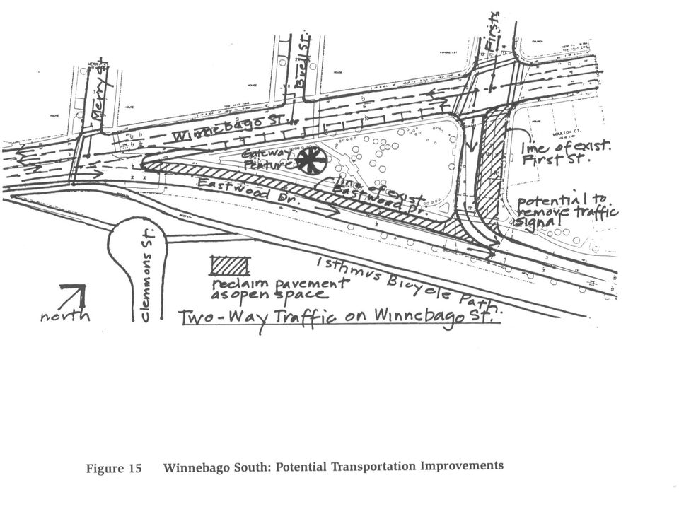
3 MASTER PLAN RECOMMENDATIONS A comprehensive list of Master Plan recommendations was prepared for the Schenk-Atwood Business District based on a review of recent plans and information, an inventory and analysis of existing conditions, an assessment of market potential, worksessions with the steering committee and City staff, and public input sessions. Short-term projects that will establish a framework for neighborhood rehabilitation, business improvements and new development activities were also identified. Transportation Recommendations Traffic Circulation In the mid 1970 s, major street improvements were implemented in the Isthmus area in the Schenk-Atwood Business District to redirect traffic away from neighborhood streets. While these improvements were helpful in reducing traffic congestion in the neighborhood, they also isolated the business district, resulting in difficulty and confusion for customers to find and enter the district. The Schenk-Atwood Business District Master Plan recommends that the historic traffic patterns and the relationship of Schenk s Corners to the arterial street system be re-established while continuing to allow commuters to bypass the district on Eastwood Drive and First Street. Several intersection and street design improvements have been recommended in the master plan, including the redesign of the intersections at Winnebago Street/Eastwood Drive (west) and Atwood Avenue/Eastwood Drive (east) to provide two-way access and egress for the district. Pedestrian and Bicycle Accommodations The Schenk-Atwood Business District is located at the center of several neighborhoods, and many community residents traverse the district on foot or by bicycle to reach work, school, or other destinations. Currently, arterial streets and the rail corridor are barriers that present challenges for safe pedestrian and bicycle access through and around the district. The master plan recommends several pedestrian and bicycle circulation improvements, including safer street crossings, additional sidewalks such as Amoth Court, parking lot designs that provide dedicated walkways, and improved bicycle paths. Mass Transit According to the 1998 Isthmus 2020 Committee Report, more than 50% of neighborhood residents in this area journey to work by means other than single occupancy vehicle. The master plan recommends improved bus connections and facilities and future commuter rail service to enhance transportation choices for residents, visitors and customers and to strengthen the connections between the business district and the community. Parking Recommendations The Schenk-Atwood Business District includes a system of public and private parking facilities that collectively support the district s customer, employee and resident parking needs. While the interviews conducted during the planning process did not indicate a parking problem, it is important to maintain an adequate, convenient and attractive parking supply to meet the district s current and future parking needs and enhance the economic success of the 4 business district. The master plan recommends additional areas where onstreet and off-street parking can be provided, opportunities for shared parking, and zoning ordinance changes that allow greater flexibility for businesses to meet their parking requirements. Redevelopment Recommendations A number of recent initiatives including Isthmus 2020 and the Dane County BUILD program have encouraged infill development and the renovation of existing building stock in areas where there is already an existing infrastructure as sound, smart growth policy. Analysis of the business district indicates that large parts of the district have been assembled in common ownership, and interviews with property owners indicate a strong interest to redevelop and/or rehabilitate these properties. The master plan identifies several sites for both short-term and long-term development, rehabilitation and historic preservation, and provides design guidelines for how these sites should be developed to achieve a unified and coordinated land use pattern that complements and enhances the character of the neighborhood. Business Mix In the early 1900s, the Schenk-Atwood Business District was considered the downtown of eastside Madison. Today, surrounded by a stable housing stock, neighborhood schools and churches, and convenient public transportation, the Schenk-Atwood neighborhood retains strong viability and is considered to be one of Madison s most successful neighborhood retail districts. The master plan recommends building on this foundation by recruiting new neighborhood-serving and community destination businesses, and by clustering related businesses together that complement one another and the adjoining land use mix and traffic patterns. Streetscape and Open Space Recommendations Enhancing the streetscape and visual character of the Schenk-Atwood Business District will be necessary to create a stronger identity for the district as a retail destination and to establish a pedestrian character that reflects the best principles of traditional Main Street design. The master plan recommends several improvements to enhance the visual and pedestrian character of the business district focusing on developing a Town Square at Schenk s Corners as a focal point for the district, expanding open spaces and landscaped areas, creating attractive entrances to the district, and providing streetscape improvements. Design Guidelines General design guidelines were prepared for the Schenk-Atwood Business District to address how new development and rehabilitation can preserve and enhance the historic architectural character of the area, including: Preservation of historically significant buildings. Rehabilitation of commercial and residential buildings to enhance their traditional design features. How new infill development can complement the scale and character of the adjoining historic buildings and maintain the integrity of the historic block face. The master plan recommends that a committee be formed to prepare detailed design guidelines, and then to use these guidelines to review proposed projects. It is recommended that this be a consensus-based body of neighborhood stakeholders, including members from both SARA and the Schenk-Atwood-Starkweather-Yahara Neighborhood Association (SASY). IMPLEMENTATION STRATEGY A key component to any master planning work is the ability to implement the plan s recommendations. There needs to be an organized structure to coordinate and monitor implementation priorities. The Schenk/Atwood Revitalization Association (SARA) has played an important role in the neighborhood for over 20 years, installing beautiful neighborhood gardens, spearheading an elderly housing development on an underutilized site, assisting in a land swap with the City of Madison to make way for the development of the Eastwood Court Apartments, and participating in the purchase and renovation of the Barrymore Theatre to retrieve it from an undesirable use to the live performance venue it is today. The master plan recommends that SARA, working closely with the City and the neighborhood, should assume the leadership role in implementing the master plan. SARA should organize into a project management team (PMT) with a structure of subcommittees similar to the Bassett Neighborhood PMT. The plan outlines the key steps that this new organization should undertake to guide implementation. The implementation strategy prioritizes the following public projects for implementation: Intersection reconstruction to improve traffic flow Development of a Town Square at Schenk s Corners Gateway entrance improvements Pedestrian crossing improvements Bicycle circulation improvements Improved bus connections and facilities Landscape, public art and park improvements for the Isthmus Bicycle Parkway Street reconstruction coordinated with new development The plan also identifies a possible phasing strategy for redevelopment activities, and how public infrastructure improvements should be coordinated with these activities. Finally, the plan recommends that a Tax Incremental Financing District (TIF) be created for the business district, based on the real possibility that a number of significant developments will occur at the Dean Clinic site, the Bank One site and the Central Atwood area. It will be desirable to capture the income derived from these developments to fund public improvements recommended for the business district.

4 T11 T11 T11 T15, T16 R11 T10 T10 S2 T6 P8 P7 T6 S8 S5 S5 S8 S1 T2 S5, S7, T15, T16 S5, S7 P8 R1 R2 R6 T7 R14 S3, P6 Schenk-Atwood Neighborhood Business District Master Plan Figure 5: Master Plan Recommendations S4 S6 T4 P3 S8 R3 T1 R12 R15 T8 T9 P8 T14 R14 T5 S5 S4 R3 R5 P9 R15 R8 P2 P1 R13 R13 R8 R7 S5, S7 R4 S1 S10, T14 T5 S9 P5 R10 S1 R9 P4 S4 T1 27

5 Transportation The following recommendations identify specific transportation improvements for Schenk-Atwood Business District including automobile, transit, pedestrian and bicycle circulation and commuter rail. Important considerations for transportation improvements include improving access to the district for all travel modes in a manner that is consistent with community transportation goals; strengthening the district as a neighborhood and community destination; and providing safe, attractive and convenient pedestrian circulation patterns. These recommendations have been developed in consultation with the city and the neighborhood. It will be necessary to further evaluate and refine these recommendations with more detailed transportation analysis and design prior to implementation. T1 T2 T4 T5 T6 T7 T8 T9 T10 T11 Intersection improvements to allow two-way traffic flow on Winnebago Street. Terminate Winnebago Street at Milwaukee Street to discourage through traffic. Reconstruct First Street south of Winnebago Street for one-way traffic flow into Eastwood Drive. Reclaim existing pavement for parkway and open space use. Intersection and street improvements for Atwood Avenue, Eastwood Drive, Division Street and Dunning Street to allow two-way eastbound traffic on Atwood, a four-legged intersection at Dunning, and a reduction in street width on Division. Reconstruct Amoth Court with on-street parking and a sidewalk on one side. Vacate the end of Helena Street for use by Schoep s as a truck loading facility. Reconstruct the intersection of Atwood Avenue and First Street to eliminate the free flow right turn. Provide a safe pedestrian crossing on First at Atwood Avenue and East Main Street. Construct a new two-way street to allow better access between Atwood Avenue and Winnebago Street with one side on-street parking. Evaluate potential to reduce the width of Atwood Avenue intersection to expand the Town Square and provide better defined pedestrian crossings. Maintain efficient one-way traffic flow on Atwood Avenue. Reconstruct Winnebago Street intersection at Atwood Avenue and Second Street to provide additional terrace and landscape space and a safer intersection for automobile, pedestrian and bicycle circulation. Provide better defined ped./bike crossings on East Washington Avenue at First Street, Second Street and Fourth Street. Provide better defined ped./bike crossings on Eastwood Drive at First Street, Russell Street and Amoth Court. Provide better defined pedestrian crossings on Atwood Avenue at Amoth Court, Rusk Street, and Corscot Court, and Winnebago Street at Russell Street and the new street near Bank One. Evaluate the location for a future commuter rail station between First Street and Second Street. Possible locations include the area west of Second Street near the existing post office; the Dean Clinic site at the extension of the new street (T7); and the parking lot at the junction of the rail lines east of First Street. Each site must accommodate a bus loop for transit connections and provide convenient pedestrian access to retail uses. Long-term transit parking is discouraged. 29 Master Plan Recommendations

6
Downtown Tampa Transportation Vision
 Downtown Tampa Transportation Vision Executive Summary August 1, 2006 Hillsborough County Metropolitan Planning Organization County Center, 18 th Floor Tampa, Florida 33602 813-272-5940 www.hillsboroughmpo.org
How To Plan A City Of Mason
 Transportation Master Plan (TMP) for the City of Madison: Draft Scope of Work Briefing for Madison Area TPB/MPO June 6, 2012 TMP: Overview/Purpose Help Create Walkable, Bikeable, Livable City - Strengthen
Near West Side Comprehensive Plan Executive Summary (Revised) April 2004 City of Milwaukee DCD
 April 2004 City of Milwaukee DCD") Near West Side Comprehensive Plan Executive Summary (Revised) April 2004 City of Milwaukee DCD Boundaries The Near West Side Comprehensive Plan covers a broad area immediately west of Milwaukee s downtown.
Near West Side Comprehensive Plan Executive Summary (Revised) April 2004 City of Milwaukee DCD Boundaries The Near West Side Comprehensive Plan covers a broad area immediately west of Milwaukee s downtown.
 Walkable Communities Florida Department of Transportation State Safety Office Pedestrian and Bicycle Program April 1995 www.dot.state.fl.us/safety Twelve Steps for an Effective Program Page 1 Twelve Steps
Topic 2 11/28/2012 Blocks & Street Network
 TOPIC 2 Blocks & Street Network Implementation Note: 1. Some recommendations are summarized in the tables herein. For complete recommendation language, please see the. 2. Recommendations referenced in
Attachment B Policy Audit Template
 Attachment B Policy Audit Template 5 6 7 8 9 0 Provide A Variety of Transportation Choices Provide A Variety of Transportation Choices Provide A Variety of Transportation Choices Encourage transit-oriented
Chicago Neighborhoods 2015: Assets, Plans and Trends A project of The Chicago Community Trust
 NEAR WEST SIDE Near West Side Area Land Use Plan July 2000 Community Area: Near West Side Department of Planning and Development (DPD), Alderman Walter Burnett, University of Illinois at Chicago (UIC),
Goals & Objectives. Chapter 9. Transportation
 Goals & Objectives Chapter 9 Transportation Transportation MISSION STATEMENT: TO PROVIDE A TRANSPORTATION NETWORK CAPABLE OF MOVING PEOPLE AND GOODS EFFICIENTLY AND SAFELY. T he transportation system
Draft Goals and Objectives Wadena Comprehensive Plan City of Wadena, Minnesota. Land Use Goals:
 Draft Goals and Objectives Wadena Comprehensive Plan City of Wadena, Minnesota Land Use Goals: 1. Growth in Wadena will be undertaken in such a manner as to create a full range of living, working, shopping,
Volume II Recommendations January 2006 City of Madison Comprehensive Plan
 2 LAND USE THE PLAN: GOALS, OBJECTIVES, POLICIES AND IMPLEMENTATION RECOMMENDATIONS Volume II Recommendations January 2006 TABLE OF CONTENTS Land Use Overview...2 1 Summary of Land Use Issues...2 2 Accommodating
Comprehensive Plan Policies that support Infill and Mixed Use
 Comprehensive Plan Policies that support Infill and Mixed Use Introduction A comprehensive plan provides a broad vision for the future growth of a community. It is often formulated using community visioning
Downtown Core Sub-district
 3-10 Land Use Downtown Core Sub-district District development will be most intense and most urban in character in the Downtown Core. The objective is to establish this area as a citywide and regional retail
1. Land Use. Chapter 1: Land Use 1-1 Adopted 10/2/09 Amended 3/22/11, 8/16/11
 1. Land Use Minneapolis will develop and maintain a land use pattern that strengthens the vitality, quality and urban character of its downtown core, commercial corridors, industrial areas, and neighborhoods
VISION, DESIGN PRINCIPLES & OVERALL PLANNING STRATEGY
 3 VISION, DESIGN PRINCIPLES & OVERALL PLANNING STRATEGY The overall planning strategy for the Bank Street CDP is to ensure that future development is undertaken in a coordinated and planned approach, supported
S U S TA I N A B L E C O M M U N I T I E S : EAST NEW YORK
 S U S TA I N A B L E C O M M U N I T I E S : EAST NEW YORK REGIONAL ACCESS MIDTOWN 30 40 mins (A) LOWER MANHATTAN 18 25 mins (A) JAMAICA 9 Mins (LIRR) NASSAU CENTER 32 mins (LIRR) DOWNTOWN BROOKLYN 15-20
28.0 Development Permit Area #2 (Neighbourhood District)
") 28.0 Development Permit Area #2 (Neighbourhood District) Goals and Objectives To provide a guide for infill and new development in the Neighbourhood District. To outline the nature, form and character
28.0 Development Permit Area #2 (Neighbourhood District) Goals and Objectives To provide a guide for infill and new development in the Neighbourhood District. To outline the nature, form and character
DIVISION STREET CORRIDOR STRATEGY Arlington, Texas May 17, 2012
 DIVISION STREET CORRIDOR STRATEGY Arlington, Texas May 17, 2012 Project Review: DCAC Meeting #2 March 8, 2012 Reviewed stakeholder meetings Online survey findings Market Assessment Macro Market Factors,
Chapter 9: Transportation
 Chapter 9: Transportation What is this chapter about? The goals and policies in this chapter convey the City s intent to: Create a coordinated, efficient, and more affordable multimodal transportation
Salt Lake City Granary District. Transit Oriented, Mixed Use Development
 Salt Lake City Granary District Transit Oriented, Mixed Use Development Introduction Matt Dahl, Project Manager Redevelopment Agency of Salt Lake City The mission of the Redevelopment Agency of Salt Lake
Lincoln Downtown Master Plan Update
 Lincoln Downtown Master Plan Update Table of Contents Executive Summary........................................... 1 Complete Streets Framework.................................... 3 Promenade Creating
Chapter 13: Implementation Plan
 Chapter 13: 13.1. INTRODUCTION The purpose of the implementation chapter of the Comprehensive Plan is to set forth the actions that the City will take to ensure that the plans, programs and policies set
OVERVIEW PROJECT SUMMARY
 OVERVIEW Cesar Chavez showcases how to successfully redesign a primary arterial route into a neighborhood destination, improving modal share, water sensitive design, biodiversity and safety whilst maintaining
For more information, visit: rethinkingstreets.com
 For more information, visit: rethinkingstreets.com 37 Arterial Rehab Busy, multi-lane streets, often referred to as arterials, crisscross the landscape of our cities and suburbs. Alongside these wide thoroughfares,
N Street Protected Bikeway
 N Street Protected Bikeway The N Street Protected Bikeway project was identified in the 2005 City of Lincoln Downtown Master Plan and the 2012 Downtown Master Plan Update as the completion of the last
The Lancaster Medical District Master Plan. The Lancaster Campus District 1
 The Lancaster Medical District Master Plan The Lancaster Campus District 1 Table of Contents 1 INTRODUCTION 3 2 THE PLANNING PROCESS 4 Assumptions 6 3 PLANNING CONTEXT AND ECONOMIC OUTLOOK 7 Site Analysis
Indianapolis SDAT. Neighborhood Restoration
 Neighborhood Restoration Working Toward a Sustainable Future live * work * play October 30 th, 2009 Message Hear concerns Build consensus Provide Recommendations Transition from Fragmentation/disconnect
Rapid City Downtown Area Master Plan. Draft Plan Concepts April 2016
 Rapid City Downtown Area Master Plan Draft Plan Concepts April 2016 CALL TO ACTION! A Thriving Downtown = Regional Economic Prosperity Rapid City is competing nationally for a limited supply of young skilled
Florida Avenue Multimodal Transportation Study. June 19, 2013
 Florida Avenue Multimodal Transportation Study June 19, 2013 Today s Agenda Team & project introduction Project Timeline What you said Tools we use Mapped data and what clues it can provide Highlights
# U N I V E R S I T Y A V E N U E S P E C I F I C P L A N Page 1-1 # 1.0 INTRODUCTION. 1.1 University Avenue, Historical Context
 1.0 INTRODUCTION 1.1 University Avenue, Historical Context By the late 1880s, the role of University Avenue, then known as Eighth Street, was already well established as a link between the original Riverside
Los Angeles Union Station, CA Sustainable Neighborhood Assessment. April 22-23, 2014
 Los Angeles Union Station, CA Sustainable Neighborhood Assessment April 22-23, 2014 Sustainable Neighborhood Assessment Through the Sustainable Neighborhood Assessment Tool developed by Global future development
GARFIELD BOULEVARD. concept planning 54TH PL CALUMET AVE ELLSWORTH DR CTA STATION STUDY AREA GAS STATION GARFIELD BLVD PRAIRIE AVE
 GARFIELD BOULEVARD concept planning PRAIRIE AVE CTA STATION CURRENCY EXCHANGE CAFE ARTS INCUBATOR CALUMET AVE 54TH PL GAS STATION GARFIELD BLVD MUFFLER SHOP 55TH PL DR MARTIN LUTHER KING JR DR STUDY AREA
BASSETT CREEK VALLEY MASTER PLAN OPEN HOUSE
 BASSETT CREEK VALLEY MASTER PLAN OPEN HOUSE February 23, 2006 PROJECT INTRODUCTION Project Area 230 acres $50 million estimated market value (approximately) 50 acres parkland 100 residences (estimated)
Citizen Advisory Group Meeting #1 December 8, 2011 6:00 p.m.
 Citizen Advisory Group Meeting #1 December 8, 2011 6:00 p.m. Meeting Agenda 1. Background Information 2. Policy Framework 3. Plan Development Process 4. Public Input Results 5. Vision Statement 6. Group
Eagle Commuter Rail Denver, Colorado Final Design (Based upon information received by FTA in November 2010)
") Eagle Commuter Rail Denver, Colorado Final Design (Based upon information received by FTA in November 2010) Summary Description Proposed Project: Electrified Commuter Rail 30.2 Miles, 13 Stations Total
Eagle Commuter Rail Denver, Colorado Final Design (Based upon information received by FTA in November 2010) Summary Description Proposed Project: Electrified Commuter Rail 30.2 Miles, 13 Stations Total
EPA Technical Assistance for Sustainable Communities Building Blocks
 EPA Technical Assistance for Sustainable Communities Technical Assistance Tool: Complete Streets Deerfield Beach, Florida February 16, 2012 To: CC: Amanda Martinez, City of Deerfield Beach Roger Millar,
Summary Community Workshop #2 Fruitvale San Antonio Senior Center. Wednesday, April 22, 2009 7:00-9:00 p.m.
 Summary Community Workshop #2 Wednesday, April 22, 2009 7:00-9:00 p.m. Workshop Format and Process The City of Oakland is preparing a Specific Plan that will help define and determine a common vision for
East Somerville. What is important to me Survey Results
 What is important to me Survey Results The What is important to me survey was used at the Somerville by Design: Crowdsourcing meeting on May 28, 213. About 35 people filled out the survey at that meeting,
Corridor Goals and Objectives
 Corridor Goals and Objectives This chapter presents the goals and objectives, developed by the Corridor Study Committee, that serve as the purpose and intent of the Corridor Plan. This plan covers a twenty
VANDERBILT COMPARISON
 Village of Vanderbilt Comparison One County, One Vision Master Plan (2000) 1 15 Improve recreation in Otsego County by assessing the availability and need to improve bike paths, county recreation facilities,
3.1 Historical Considerations
 3. Recommended Scope of Bridge improvements 3.1 Historical Considerations In the fall of 2000, an outside consultant, Fraser Design, suggested that the existing 4 th St. Bridge is potentially eligible
Envision Venice Strategic Plan for Fiscal Year Ending. September 30, 2016. Preserving and Enhancing the Venice Quality of Life.
 Adopted April 28, 2015 October 1, 2015 through September 30, 2016 Envision Venice Strategic Plan for Fiscal Year Ending September 30, 2016 Preserving and Enhancing the Venice Quality of Life Table of Contents
Request for Information
 Request for Information Date of Issue: February 13, 2015 Responses Due: May 29, 2015 Overview Forest West Properties Inc. (FWP) is soliciting qualifications from qualified developers for the development
TRANSPORTATION SERVICE STANDARDS ELEMENT GOALS, OBJECTIVES & POLICIES
 TRANSPORTATION SERVICE STANDARDS ELEMENT GOALS, OBJECTIVES & POLICIES Background One of the most critical public services provided by a community is the community s transportation system. An effective
21.04 LAND USE. Managing amenity through land use strategies
 21.04 LAND USE This section contains objectives and strategies for land use, under the themes of: Housing and community Retail, entertainment and the arts Office and commercial use Industry Education and
Motorcycle & Pedestrian Master Plans in Indianapolis, Indiana
 PROJECT PURPOSE The Warsaw + Winona Lake Bicycle and Pedestrian Master Plan establishes a comprehensive framework for a connected bicycle and pedestrian system that will be used for both recreation and
Appendix C Related Studies
 Appendix C Related Studies Intermodal Transit Village Concept Plan Appendix C Related Studies This appendix summarizes studies that are current at the time of this Plan. Intermodal Transit Village Concept
Introduction to Station Area Planning The Charlotte Story
 Introduction to Station Area Planning The Charlotte Story Boston 2009 Steve Hamwey - Sasaki Associates, Inc. Troy Russ - Glatting Jackson, Inc. October 31 st, 2009 Station Area Planning October 15th History
North Avenue Corridor Study. Advisory Committee Meeting #5 June 11, 2014
 North Avenue Corridor Study Advisory Committee Meeting #5 June 11, 2014 Agenda Welcome and introductions Concept refinement and evaluation: Public meeting and web survey General cross-section concepts
PLANNING DIVISION STAFF REPORT February 23, 2015. Summary. Background Information PREPARED FOR THE PLAN COMMISSION. Legistar File ID # 36810
 PLANNING DIVISION STAFF REPORT PREPARED FOR THE PLAN COMMISSION Project Address: Application Type: Legistar File ID # 36810 Prepared By: Summary Conditional Use Timothy M. Parks, Planning Division Report
TABLE OF CONTENTS. Executive Summary 1-3. Introduction 4-6. Illustrative Site Plan 7. East-West Streets 8. Cooper Street 9-10. Market Street 11-14
 TABLE OF CONTENTS Executive Summary 1-3 Introduction 4-6 Illustrative Site Plan 7 East-West Streets 8 Cooper Street 9-10 Market Street 11-14 Federal Street 15-16 MLK Boulevard 17-20 North-South Streets
Guiding Principles. McCauley Area Focused Urban Design Plan. 1 Connect: Chinatown and Little Italy with downtown and surrounding areas
 McCauley Area Guiding Principles 1 Connect: Chinatown and Little Italy with downtown and surrounding areas 2 Strengthen: Cultural character in Chinatown and Little Italy 3 Develop: Strong East West pedestrian
APPENDIX F RIGHTS-OF-WAY PRESERVATION GUIDELINES
 Los Angeles County Metropolitan Transportation Authority (Metro) 2009 Transportation Improvement Program Call for Projects APPENDIX F RIGHTS-OF-WAY PRESERVATION GUIDELINES Los Angeles County Metropolitan
HARRIS TEETER AT LADY S ISLAND CITY OF BEAUFORT DRB CONCEPTUAL PROJECT NARRATIVE Submittal Date: September 2, 2015 Meeting Date: September 10, 2015
 HARRIS TEETER AT LADY S ISLAND CITY OF BEAUFORT DRB CONCEPTUAL PROJECT NARRATIVE Submittal Date: September 2, 2015 Meeting Date: September 10, 2015 PROPOSED REDEVELOPMENT The project consists of demolishing
Planning of the Pre-Concept Architectural Design For the McGill University Health Centre, Montreal
 Planning of the Pre-Concept Architectural Design For the McGill University Health Centre, Montreal Robert Hamilton Robert A. Hamilton MRAIC, OAQ Robert Hamilton is Senior Associate responsible for Architectural
Environmental Impact Statement for the Washington Union Station Expansion Project
 This document is scheduled to be published in the Federal Register on 11/04/2015 and available online at http://federalregister.gov/a/2015-28079, and on FDsys.gov 4910-06-P DEPARTMENT OF TRANSPORTATION
Revere Beach Transit-Oriented Development Parcels Revere, Massachusetts. Design and Development Guidelines. Part Two.
 Revere Beach Transit-Oriented Development Parcels Revere, Massachusetts Design and Development Guidelines Request for Qualifications and Expressions of Interest with Preliminary Development Plans Part
30 Years of Smart Growth
 30 Years of Smart Growth Arlington County s Experience with Transit Oriented Development in the Rosslyn-Ballston Metro Corridor A Presentation by the Arlington County Department of Community Planning,
Land Use and Zoning. Land Use Within the Port Madison Indian Reservation
 Land Use and Zoning Land Use Within the Port Madison Indian Reservation A portion of the Suquamish Rural Village is Trust land, owned either by the Tribe or individual tribal members. The following list
Examples of Transportation Plan Goals, Objectives and Performance Measures
 Examples of Transportation Plan Goals, Objectives and Performance Measures The next step in the Long Range Transportation Plan (LRTP) process is to develop goals, objectives, and performance measures.
2010 Salida Community Priorities Survey Summary Results
 SURVEY BACKGROUND The 2010 Salida Community Priorities Survey was distributed in September in an effort to obtain feedback about the level of support for various priorities identified in the draft Comprehensive
Development Layout Design
 Development Layout Design General Design Considerations for Adoptable Highways Version 1 June 2012 Transportation, Waste and Environment Service Issue and Revisions Record Revision Date Originator Purpose
GEORGIA COLLEGE & STATE UNIVERSITY
 MASTER PLAN GEORGIA COLLEGE & STATE UNIVERSITY 1 EXECUTIVE SUMMARY Prepared by Sasaki Associates, Inc. Georgia College & State University Campus Master Plan with Lord, Aeck & Sargent The Jaeger Company
MILWAUKEE. Plan. comprehensive DEPARTMENT OF CITY DEVELOPMENT MARCH, 2010 EXECUTIVE SUMMARY
 MILWAUKEE Plan DEPARTMENT OF CITY DEVELOPMENT MARCH, 2010 comprehensive CITYWIDE POLICY PLAN EXECUTIVE SUMMARY INTRODUCTION AND OVERVIEW I. OVERVIEW OF COMPREHENSIVE SMART GROWTH PLAN SERIES The series
Iowa Smart Planning. Legislative Guide March 2011
 Iowa Smart Planning Legislative Guide March 2011 Rebuild Iowa Office Wallace State Office Building 529 East 9 th St Des Moines, IA 50319 515-242-5004 www.rio.iowa.gov Iowa Smart Planning Legislation The
Tier 1 Strategies. WV Route 14 Corridor Management Plan
 1.1 1.2 1.3 1.4 Signal timing optimization system improvements. Improve geometry traffic control at high crash intersections. Construct intersection capacity improvement projects. Widen longer sections
Ohio Department of Transportation. Lytle Tunnel Rehabilitation Phase 2 Public Information Meeting
 Ohio Department of Transportation John R. Kasich, Governor Jerry Wray, Director Lytle Tunnel Rehabilitation Phase 2 Public Information Meeting HAM-71-1.34, PID 87268 July 23, 2013 Project Overview Purpose
Alternatives to the Circ Project Prioritization Methodology Prepared for Circ Task Force July 28, 2011
 Alternatives to the Circ Project Prioritization Methodology Prepared for Circ Task Force July 28, 2011 CCRPC staff has developed a draft methodology described below and detailed in the attached pages for
G. Syracuse RESTORE III The Connective Corridor: Building Upwards (W828) June 24, 2010. General Project Plan
 June 24, 2010. General Project Plan") General Project Plan Grantee: City of Syracuse (the City or Syracuse ) Beneficiary Company: 215 West Fayette Street Associates, LLC ESD Investment: Project Locations: A grant of up to $1,300,000, pending
General Project Plan Grantee: City of Syracuse (the City or Syracuse ) Beneficiary Company: 215 West Fayette Street Associates, LLC ESD Investment: Project Locations: A grant of up to $1,300,000, pending
Prepared by: Samuel Dennis Date prepared: December 21, 2011
 Hillsborough County City-County Planning Commission EXECUTIVE SUMMARY Meeting Date: Agenda Item: January 9, 2012 - Planning Commission Public Hearing Tampa: Text Amendment to Public/Semi-Public Land Use
Philadelphia County. Land Use and Growth Management Profile
 Philadelphia County is located in the southeastern corner of Pennsylvania and is bordered by the Pennsylvania counties of Delaware, Montgomery, and Bucks, and the New Jersey counties of Burlington, Camden,
Downtown Los Angeles Streetcar Economic Analysis
 Downtown Los Angeles Streetcar Economic Analysis Executive Briefing Prepared for: Los Angeles Streetcar, Inc. 550 S. Hope Street, Ste. 2300 Los Angeles, CA 90071 Prepared by: AECOM 515 S. Flower Street,
CITY OF FLORENCE NEIGHBORHOOD REVITALIZATION STRATEGY SECOND PUBLIC MEETING
 CITY OF FLORENCE NEIGHBORHOOD REVITALIZATION STRATEGY SECOND PUBLIC MEETING Prepared for: City of Florence July 7th, 2014 AGENDA Review Feedback from First Community Meeting Present Catalytic Project Areas
www.thefurlongphase2.co.uk
 Welcome Thank you for coming along today to view our plans for Phase 2 of The Furlong Shopping Centre. We are undertaking a consultation programme that will run up to and beyond submission of the planning
Overview of Transportation Planning
 Chapter 7: Transportation Overview of Transportation Planning Transportation planning deals with the movement of people and goods throughout a city or a region and is not limited to automobiles and streets
Introduction. Residential Development. Plan Foundation. Growth Management Concepts
 Introduction The land use element of the comprehensive plan created a roadmap for future growth and development patterns in the Village of Plain City. The plan designated areas for future residential,
Implementation Strategy
 Implementation Strategy 6 The following implementation strategy defines strategic points of intervention for complete streets programming, including visioning, goal-setting, local agency plans, coordination
Atlanta Regional Commission s Lifelong Communities Initiative: Creating Communities for All Ages and Abilities
 Atlanta Regional Commission s Lifelong Communities Initiative: Creating Communities for All Ages and Abilities Laura Keyes, MS, AICP and Cathie Berger, LMSW The Atlanta region is experiencing a monumental
Light Rail Transit in Phoenix
 4. Presentation and Discussion: Phoenix Light Rail Implementation Wulf Grote Planning and Development Director, Phoenix Valley Metro Light Rail Transit in Phoenix Broadway Citizen s Task Force February
A new Garden Neighbourhood for West Guildford An opportunity for Smart Growth. university of surrey November 2013
 A new Garden Neighbourhood for West Guildford An opportunity for Smart Growth university of surrey November 2013 A new Garden Neighbourhood for West Guildford Preface Since the County and Borough Councils
Downtown Community Planning Council Meeting offebruary 18, 2015
 - san diego Item #12 DATE ISSUED: ATTENTION: SUBJECT: February 13, 2015 Downtown Community Planning Council Meeting offebruary 18, 2015 Consideration of Support for Grant Applications for the San Diego
MAIN STREET IMPROVEMENTS Water, Sewer, Stormwater and Streetscape Improvements
 MAIN STREET IMPROVEMENTS Water, Sewer, Stormwater and Streetscape Improvements Presentation July 23, 2014 A. Morton Thomas and Associates, Inc. 800 King Farm Boulevard, 4 th Floor Rockville, Maryland 20850
INTRODUCTION TO ZONING DISTRICT REGULATIONS
 INTRODUCTION TO ZONING DISTRICT REGULATIONS Classification of Zoning Districts Zoning districts in Dorchester County are categorized as Suburban Urban, Suburban Transition, or Rural. These districts are