D3 April 8, 2015 Public Hearing
|
|
|
- Alexina Melissa James
- 7 years ago
- Views:
Transcription
1 D3 April 8, 2015 Public Hearing APPLICANT AND PROPERTY OWNER: ASSEMBLY OF YAH, INC. STAFF PLANNER: Kevin Kemp REQUEST: Conditional Use Permit (Religious Facility - church) ADDRESS / DESCRIPTION: 5151 Locke Lane GPIN: ELECTION DISTRICT: KEMPSVILLE SITE SIZE: 28,220 square feet AICUZ: Less than 65 db DNL APPLICATION HISTORY: This application was deferred on March 11 due to the lack of proper public notice (public notice signs were not posted). BACKGROUND / DETAILS OF PROPOSAL The applicant requests a Conditional Use Permit for the purpose of constructing a 3,400 square foot, one-story addition to an existing church building. City records indicate that the existing building was constructed in 1950, predating the adoption of the Zoning Ordinance. Because a religious use has continuously occupied the site, no Conditional Use Permit exists for the church. The applicant desires to enlarge the church building, and; therefore, a Conditional Use Permit is required. This application was deferred from the March 11, 2015 Planning Commission to allow for the applicant to post the required notification signs on the site. The subject site contains a one-story, 2,513 square foot brick building situated in the center of the site, as well as a small gravel parking area. Access to the site is from Locke Lane. There is mature plant material along Locke Lane and Kempsville Road, as well as numerous mature trees throughout the site, particularly in the rear. The addition will contain a new sanctuary space as well as facilities to accommodate various office and Page 1

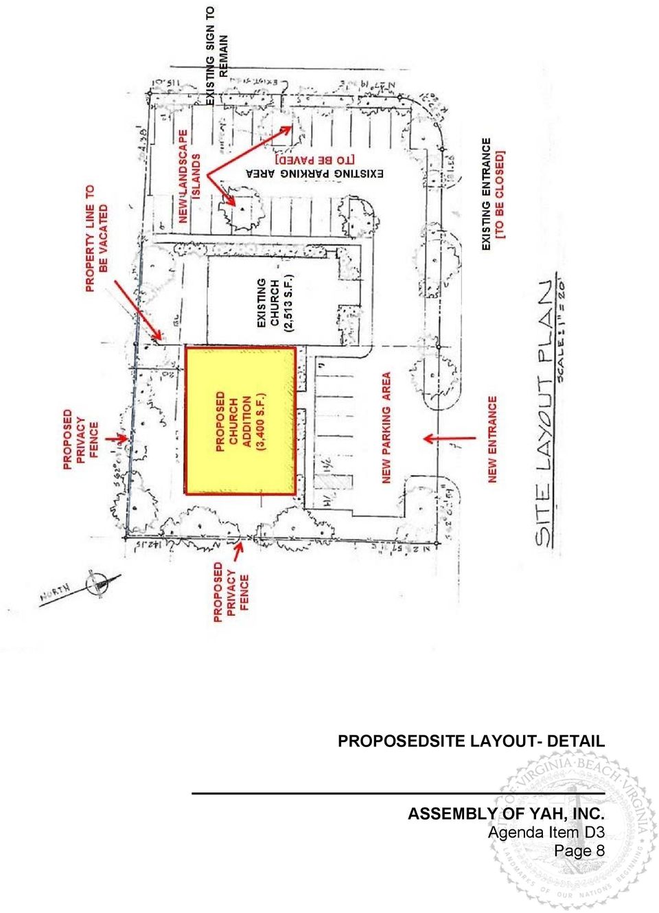
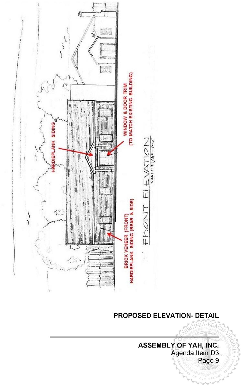
2 fellowship activities. The church has a congregation of approximately 100 people, and the proposed addition will accommodate 40 additional seats. No day care, school, or housing accommodations are proposed with this application. The proposed 3,400 square foot addition extends from the rear (eastern side) of the existing building. The addition is designed to match the existing building in both style and material. The front façade facing Locke Lane will be brick and the side and rear facades will be Hardieplank fiber-cement siding. A new paved parking area will be installed adjacent to Locke Lane to accommodate the additional parking required due to the addition. The existing parking area will also be paved, striped, and landscaped to meet City standards. The existing landscaping along Locke Lane and Kempsville Road will be enhanced or replaced to meet the standards of the City Landscaping Guide, including additional planting around the free-standing sign. A six-foot privacy fence, as well as Category IV landscaping will be installed along the south and east property lines to provide screening from the adjacent properties. EXISTING LAND USE: Religious facility LAND USE AND COMPREHENSIVE PLAN SURROUNDING LAND USE AND ZONING: North: Locke Lane Single-family dwellings / R-10 Residential District South: Professional and medical offices / O-2 Office District East: Single-family dwellings / R-10 Residential District West: Kempsville Road Religious facility (church) / A-12 Apartment District NATURAL RESOURCE AND CULTURAL FEATURES: A portion of the site is developed with a one-story building and gravel parking area. The remainder of the site is undeveloped land containing several mature trees. The site is located in the Chesapeake Bay Watershed. There are no known historical and cultural features of significance associated with the site. COMPREHENSIVE PLAN: The Comprehensive Plan designates this area of the city as being in the Suburban Area. The general planning principles for the Suburban Area focus on preserving and protecting the overall character, economic value, and aesthetic quality of stable neighborhoods. Achieving these goals of preserving neighborhood quality requires that all new development or redevelopment, whether residential or non-residential, either maintain or enhance the overall area. This can be accomplished through uses compatible with surroundings, attractiveness of site and buildings, environmental responsibility, livability, and effective buffering of residential from other residential and nonresidential with respect to type, size, intensity, and relationship to the surrounding uses (p. 3-1 through 3-3). IMPACT ON CITY SERVICES MASTER TRANSPORTATION PLAN (MTP) / CAPITAL IMPROVEMENT PROGRAM (CIP): Locke Page 2

3 Lane is a two-lane undivided local street. It is not included in the Master Transportation Plan. Kempsville Road is a four-lane divided minor urban arterial. The Master Transportation Plan proposes a six-lane facility within a 150-foot wide right-of-way. This segment of Kempsville Road is functioning over-capacity at a Level of Service F. There are no Roadway Capital Improvement Program projects scheduled for this area. TRAFFIC: Street Name Present Volume Present Capacity Generated Traffic Kempsville Road 29,877 ADT 1 14,800 ADT 1 (LOS 4 C ) 22,800 ADT 1 (LOS 4 D ) 27,400 ADT 1 (LOS 4 E ) Existing Land Use 2 92 ADT Proposed Land Use ADT 1 Average Daily Trips 2 as defined by a church - 2,513 square feet 3 as defined by a church - 5,913 square feet 4 LOS = Level of Service WATER: This site currently connects to City water. There are existing 16-inch, 24-inch, and 36-inch City water transmission mains along Kempsville Road. There is an existing 8-inch City water main along Locke Lane. The existing 5/8-inch water meter (City ID # ) can be used or upgraded to accommodate the proposed development. SEWER: The site currently connects to City sewer which discharges to Pump Station #417. There is an existing 20-inch HRSD force main and an 8-inch City gravity sewer main along Kempsville Road. There is an existing 8-inch City gravity sewer main along Locke Lane. EVALUATION AND RECOMMENDATION The applicant requests a Conditional Use Permit for the purpose of constructing a 3,400 square foot addition to an existing church building that will accommodate a growing congregation. Staff concludes that this request is consistent with the Comprehensive Plan s land use policies for the Suburban Area, and the use is compatible with the character of the surrounding area. The 0.64 acre site, zoned R-10 Residential District, has been used as a church for many years. The new building will add 40 seats, and this increase will have a minimal impact on the volume of traffic. The proposed addition is designed to complement the existing structure on the site and will also match the character of the surrounding properties in style and materials. The applicant proposes a number of improvements to the site, including the following: Enhanced plantings along both rights-of-way; Page 3
 22,800 ADT 1 (LOS 4 D ) 27,400 ADT 1 (LOS 4 E ) Existing Land Use 2 92 ADT")
4 Installation of a buffer, including a privacy fence and plant material along the south and east property lines to provide adequate screening between the church and the adjacent properties; Improvements to the parking area, including paving, striping and the installation of landscaped islands; Relocation of the ingress/egress point to the property further east along Locke Lane, which is a safer and more desired location; and Improvements to Locke Lane, including the installation of curbing, guttering, and a sidewalk. In sum, Staff recommends approval of this application with the conditions below. CONDITIONS 1. When developed, the site shall be in substantial accordance with the site plan entitled, SITE LAYOUT PLAN AND BUILDING ELEVATIONS ADDITION TO THE ASSEMBLY of YAH HOUSE of WORSHIP, 5151 LOCKE LANE, VIRGINIA BEACH, VA, dated August 29, 2014, and prepared by Verebely & Associates, Architects. Said plan has been exhibited to the City Council and is on file in the Planning Department. 2. When developed, the building addition shall be in substantial accordance with the submitted building elevation entitled, SITE LAYOUT PLAN AND BUILDING ELEVATIONS ADDITION TO THE ASSEMBLY of YAH HOUSE of WORSHIP, 5151 LOCKE LANE, VIRGINIA BEACH, VA, dated August 29, 2014, and prepared by Verebely & Associates, Architects. Said elevation has been exhibited to the City Council and is on file in the Planning Department. 3. When developed, the exterior of the building addition shall be finished using the materials as identified on the submitted elevation entitled, SITE LAYOUT PLAN AND BUILDING ELEVATIONS ADDITION TO THE ASSEMBLY of YAH HOUSE of WORSHIP, 5151 LOCKE LANE, VIRGINIA BEACH, VA, dated August 29, 2014, and prepared by Verebely & Associates, Architects. The front (north facing) façade shall be brick veneer to match the existing church building. The side and rear facades shall be Hardieplank fiber-cement siding. 4. A development site plan depicting the improvements enumerated in the conditions below as well as the requirements of City ordinances and standards shall be submitted to the Planning Department / Development Services Division for review and approval prior to the issuance of any permits. 5. The existing gravel parking area located between the church building and Kempsville Road shall be paved and striped to meet all City regulations applicable to parking lots. 6. A minimum of seventy-five (75) square feet of planted area shall be installed around the existing free-standing sign adjacent to Kempsville Road. The plant materials shall be consistent with and be installed in conformance with the requirements of the City Landscaping Guide. 7. The privacy fence as shown on the submitted site plan shall conform to the requirements of Section 201 (e) of the Zoning Ordinance. Chain-link fencing shall not be permitted. A permit for Page 4

5 the fencing shall be obtained from the Planning Department / Permits & Inspections Division prior to installation. 8. The applicant shall make improvements to the right-of-way (Locke Lane) as required by the Department of Public Works, including, but not limited to: the installation of curb and gutter along the entire frontage of the sites on Locke Lane, and the installation of a sidewalk in the right-ofway along the entire frontage of Locke Lane. All improvements shall be reviewed by the Development Services Center and the Department of Public Works and shall meet all City standards. 9. No Certificate of Occupancy shall be issued until a subdivision plat vacating the interior lot line has been submitted to and approved by the Development Services Center and recorded with the Clerk of the Court. 10. The applicant shall obtain all necessary permits and inspections from the Planning Department / Permits & Inspections Division and the Fire Department. NOTE: Further conditions may be required during the administration of applicable City Ordinances and Standards. Any site plan submitted with this application may require revision during detailed site plan review to meet all applicable City Codes and Standards. All applicable permits required by the City Code, including those administered by the Department of Planning / Development Services Center and Department of Planning / Permits and Inspections Division, and the issuance of a Certificate of Occupancy, are required before any uses allowed by this Use Permit are valid. The applicant is encouraged to contact and work with the Crime Prevention Office within the Police Department for crime prevention techniques and Crime Prevention Through Environmental Design (CPTED) concepts and strategies as they pertain to this site. Page 5

6 AERIAL OF SITE LOCATION Page 6

7 PROPOSED SITE LAYOUT & ELEVATION Page 7

8 PROPOSEDSITE LAYOUT- DETAIL Page 8
9 PROPOSED ELEVATION- DETAIL Page 9
10 EXISTING CHURCH BUILDING Page 10

11 EXISTING FREE-STANDING SIGN Page 11

12 1 2 ZONING HISTORY # DATE REQUEST ACTION 1 07/11/2006 Use Permit (Church addition) Approved 03/23/1993 Use Permit (Church addition) Approved 05/14/1979 Use Permit (Church) Approved 07/17/1978 Change of Zoning (A-1 to A-4) Withdrawn 2 03/24/1986 Use Permit (Private Club) Denied 11/19/1984 Change of Zoning (R-5 to O-1) Approved 01/14/1980 Change of Zoning (R-5 to O-1) Denied Page 12
 Approved 01/14/1980 Change of Zoning (R-5 to")
13 DISCLOSURE STATEMENT Page 13
14 DISCLOSURE STATEMENT Page 14
5 March 12, 2014 Public Hearing
 5 March 12, 2014 Public Hearing APPLICANT: MOORE FARM, L.L.L.P. PROPERTY OWNER: MOORE FARM L.L.L.P. STAFF PLANNER: Kevin Kemp REQUEST: Change of Zoning (B-1A Limited Community Business to Conditional B-2
7 December 10, 2014 Public Hearing APPLICANT: OBEDIENT PAWS, L.L.C.
 7 December 10, 2014 Public Hearing APPLICANT: OBEDIENT PAWS, L.L.C. PROPERTY OWNER: DIANE BLACKISTON STAFF PLANNER: Graham Owen REQUEST: Conditional Use Permit (Home Occupation) ADDRESS / DESCRIPTION:
12 February 8, 2012 Public Hearing APPLICANT:
 12 February 8, 2012 Public Hearing APPLICANT: PROPERTY OWNER: VIRGINIA BEACH ASSOCIATES, LC REQUEST: Conditional Change of Zoning (I-1 to Conditional A-36) STAFF PLANNER: Faith Christie ADDRESS / DESCRIPTION:
2 February 12, 2014 Public Hearing
 2 February 12, 2014 Public Hearing APPLICANT & PROPERTY OWNER: MATTHEW ALVES REQUEST: Conditional Use Permit (Home Occupation / firearm sales and gunsmithing) ADDRESS / DESCRIPTION: 2445 Brush Creek Lane
3 September 9, 2015 Public Hearing
 3 September 9, 2015 Public Hearing APPLICANT: PI TELECOM INFRASTRUCTURE T, LLC PROPERTY OWNER: JSW HOLDINGS, LLC STAFF PLANNER: Carolyn A.K. Smith REQUEST: Conditional Use Permit (communications tower-monopole)
PLANNED UNIT DEVELOPMENT & SIDEWALK WAIVER REQUEST STAFF REPORT Date: November 7, 2013
 PLANNED UNIT DEVELOPMENT & SIDEWALK WAIVER REQUEST STAFF REPORT Date: November 7, 2013 NAME LOCATION Audubon Properties, LLC. 4700 & 4960 Dauphin Island Parkway West side of Dauphin Island Parkway, 580
WESTFIELD-WASHINGTON ADVISORY PLAN COMMISSION December 7, 2015 1512-SPP-24 & 1512-ODP-24
 Petition Number: Subject Site Address: Petitioner: Request: East side of Oak Road, north of 151 st Street Langston Development Co. Primary Plat and Overall Development Plan amendment review for Mapleridge
FILE NO.: Z-8403. LOCATION: Located on the Northeast and Southeast corners of West 12 th Street and Dennison Street
 FILE NO.: Z-8403 NAME: Glason Short-form POD LOCATION: Located on the Northeast and Southeast corners of West 12 th Street and Dennison Street DEVELOPER: Dennis Glason c/o the Law Office of Simmons S.
AREA: 2.37 acres NUMBER OF LOTS: 1 FT. NEW STREET: 0 LF. Single-family, Non-conforming machine shop
 FILE NO.: Z-8958 NAME: Rock Structure Repair Short-form PID LOCATION: Located at 8024 Stanton Road DEVELOPER: Rock Structure Repair Attn. Rudy Gutierrez 3 Kipling Court Little Rock, AR 72209 ENGINEER:
Staff Report General Development Plan/Master Plan Aldermanic District: 1 County Commission District: 2 MPC File No. 16-000526-PLAN February 23, 2016
 Staff Report General Development Plan/Master Plan Aldermanic District: 1 County Commission District: 2 MPC File No. 16-000526-PLAN February 23, 2016 1101 Bull Street One West Park Avenue 1107 Bull Street
Industrial Suburban District Regulations City of St. Petersburg City Code Chapter 16, Land Development Regulations
 16.20.110 - Industrial Suburban District ( IS ) Figure REFERENCE Typical Buildings in the IS District Figure REFERENCE Site Plan of a typical development in the IS District Sections: 16.20.110.1 Composition
City of Colleyville Community Development Department. Site/Landscape Plan Application Packet
 City of Colleyville Community Development Department Site/Landscape Plan Application Packet Development Application Fees City of Colleyville 100 Main Street Colleyville TX 76034 817.503.1050 Zoning Zoning
SPECIAL USE PERMIT 22-01. JCSA Groundwater Treatment Facility Staff Report for the November 5, 2001, Planning Commission Public Hearing
 SPECIAL USE PERMIT 22-01. JCSA Groundwater Treatment Facility Staff Report for the November 5, 2001, Planning Commission Public Hearing This report is prepared by the James City County Planning Division
D4 - D12 May 8, 2013 Public Hearing
 D4 - D12 May 8, 2013 Public Hearing CITY OF VIRGINIA BEACH AMENDMENTS PERTAINING TO APPLICATION FEES REQUESTS: D4. An Ordinance to Amend Section 110 of the Chesapeake Bay Preservation Area Ordinance Pertaining
Division 51-4.400. Yard, Lot, and Space Regulations.
 Division 51-4.400. Yard, Lot, and Space Regulations. SEC. 51-4.401. MINIMUM FRONT YARD. (a) General provisions. (1) Required front yards must be open and unobstructed except for fences. Except as otherwise
Draft Goals and Objectives Wadena Comprehensive Plan City of Wadena, Minnesota. Land Use Goals:
 Draft Goals and Objectives Wadena Comprehensive Plan City of Wadena, Minnesota Land Use Goals: 1. Growth in Wadena will be undertaken in such a manner as to create a full range of living, working, shopping,
INTRODUCTION TO ZONING DISTRICT REGULATIONS
 INTRODUCTION TO ZONING DISTRICT REGULATIONS Classification of Zoning Districts Zoning districts in Dorchester County are categorized as Suburban Urban, Suburban Transition, or Rural. These districts are
Rezoning case no. RZ15-08: Adam Development Properties, LP
 PLANNING AND ZONING COMMISSION STAFF REPORT June 4, 2015 Rezoning case no. RZ15-08: Adam Development Properties, LP CASE DESCRIPTION: LOCATION: a request to amend the development plan of a previously-approved
TOWN BOARD OF THE TOWN OF NORTH SALEM WESTCHESTER COUNTY, NEW YORK LOCAL LAW # OF THE YEAR 2012
 TOWN BOARD OF THE TOWN OF NORTH SALEM WESTCHESTER COUNTY, NEW YORK LOCAL LAW # OF THE YEAR 2012 CHAPTER 250, ZONING ORDINANCE AMENDMENTS - PD-CCRC DISTRICT Section 1. Purpose: The purpose of this Local
ARTICLE 22. AKB ARTHUR K. BOLTON PARKWAY OVERLAY ZONE
 ARTICLE 22. AKB ARTHUR K. BOLTON PARKWAY OVERLAY ZONE Sec. 2201. Purpose. AKB is an overlay zone which governs the development of property located along the Arthur K. Bolton Parkway (Georgia Highway 16
AREA: 0.16 acres NUMBER OF LOTS: 1 FT. NEW STREET: 0 LF
 FILE NO.: Z-9020 NAME: Hometown Tax Service Short-form PD-O LOCATION: Located at 3008 West 12 th Street DEVELOPER: Mark Green 65 Westfield Loop Little Rock, AR 72210 SURVEYOR: Kittler-Roberts Group, LLP
City Code of ANN ARBOR, MICHIGAN Chapter 55 Zoning
 ARTICLE II. USE REGULATIONS 5:10.2. R1A, R1B, R1C, R1D single family dwelling district (1) Intent. (a) These single family residential districts are designed to provide an environment of predominantly
B. Improve the appearance and character of areas surrounding new development.
 Chapter 4.3: Landscape Regulations Sections: 4.301 Purposes 4.302 Applicability 4.303 General Provisions 4.304 Landscape Maintenance 4.301 Purposes The purposes of these regulations are to: A. Promote
FOR SALE Office Building
 1712 West State Street Bristol, Tennessee 37620 State TR # 13-11-003 Open house on April 26, 2016 from 1:00-3:00pm EST FOR SALE Office Building OFFERING MEMORANDUM Contact Information Jeff Jones 615-445-9984
CHAPTER 5 - "R1" SINGLE-FAMILY RESIDENTIAL DISTRICT
 CHAPTER 5 - "R1" SINGLE-FAMILY RESIDENTIAL DISTRICT Section 5-1. Regulations: The regulations set forth in this chapter, or set forth elsewhere in this ordinance when referred to in this chapter, are the
REPORT OF THE PLANNING AND DEVELOPMENT DEPARTMENT FOR APPLICATION FOR REZONING ORDINANCE 2015-0183 TO PLANNED UNIT DEVELOPMENT APRIL 9, 2015
 AWH REPORT OF THE PLANNING AND DEVELOPMENT DEPARTMENT FOR APPLICATION FOR REZONING ORDINANCE 2015-0183 TO PLANNED UNIT DEVELOPMENT APRIL 9, 2015 The Planning and Development Department hereby forwards
Churches and Schools Development Standards
 Uses Code Provisions Site Development Standards RS-4 Sec.24-44 RD Sec. 24-45 RM-23 Sec. 24-48 Residential Single Family Residential Two- Family (Duplex) Residential Mid- Rise Multifamily (High Density)
BOARD OF ADJUSTMENT STAFF REPORT. BOA File No. 3786 1515 West Avenue- Multifamily Building
 MIAMI BEACH PLANNING DEPARTMENT FROM: DATE: RE: BOARD OF ADJUSTMENT STAFF REPORT Thomas R. Mooney, AIC~ Planning Director December 4, 2015 Meeting BOA File No. 3786 1515 West Avenue- Multifamily Building
FILE NO.: Z-6915-C. Gamble Road Short-form PCD and Land Alteration Variance Request
 FILE NO.: Z-6915-C NAME: Gamble Road Short-form PCD and Land Alteration Variance Request LOCATION: Located on the Northwest corner of Chenal Parkway and Gamble Road DEVELOPER: Davis Properties P.O. Box
CITY OF WEST PALM BEACH ZONING BOARD OF APPEALS Meeting Date: February 6, 2014 Zoning Board of Appeals Case No. 3302
 CITY OF WEST PALM BEACH ZONING BOARD OF APPEALS Meeting Date: February 6, 2014 Zoning Board of Appeals Case No. 3302 1950 Golden Lakes Blvd. Class B Special Use Permit Location Aerial I. REQUEST Site is
Chapter 7 ZONING PLAN
 Chapter 7 ZONING PLAN Introduction This Chapter opens with a general description of a zoning plan. It is followed by a brief explanation of the relationship between this Growth Management Plan and the
DEPARTMENT OF DEVELOPMENT SERVICES PLANNING FEES AND COSTS Revised 10/26/2012
 ZONING DEPARTMENT OF DEVELOPMENT SERVICES PLANNING FEES AND COSTS Revised 10/26/2012 [ ] PD Sketch Plan with phasing plan $2,000 plus $20/acre over 5 acres Retainer - $1,500 [ ] PD Preliminary Site Plan
SEEKING COMPLETENESS WAIVERS AND PRELIMINARY & FINAL SITE PLAN APPROVAL
 APPLICATION & REPORTS FOR PB2009-05 INTERNATIONAL DEVELOPMENT CORPORATION SEEKING COMPLETENESS WAIVERS AND PRELIMINARY & FINAL SITE PLAN APPROVAL MEMORANDUM TO: FROM: RE: Borough of Tinton Falls
PLANNING COMMISSION REPORT Regular Agenda - Public Hearing Item
 Z-15-00063 Item No. 1-1 PLANNING COMMISSION REPORT Regular Agenda - Public Hearing Item PC Staff Report 04/20/2015 ITEM NO. 1 Z-15-00063 CS TO RS5; 832 Ohio Street (BJP) Z-15-00063: Consider a request
28.0 Development Permit Area #2 (Neighbourhood District)
") 28.0 Development Permit Area #2 (Neighbourhood District) Goals and Objectives To provide a guide for infill and new development in the Neighbourhood District. To outline the nature, form and character
28.0 Development Permit Area #2 (Neighbourhood District) Goals and Objectives To provide a guide for infill and new development in the Neighbourhood District. To outline the nature, form and character
NOTICE OF A TYPE Ix DECISION ON A PROPOSAL IN YOUR NEIGHBORHOOD
 Date: June 29, 2016 To: From: Interested Person Susan Ellis, Land Use Services 503-823-5361 / susan.ellis@portlandoregon.gov NOTICE OF A TYPE Ix DECISION ON A PROPOSAL IN YOUR NEIGHBORHOOD The Bureau of
VILLAGE OF PLEASANT PRAIRIE COMMERCIAL COMMUNICATION PERMIT
 VILLAGE OF PLEASANT PRAIRIE COMMERCIAL COMMUNICATION PERMIT CLASS 1 COLLOCATION New Commercial Communication Structure Substantial Modification Please check one of the following: CLASS 2 COLLOCATION OTHER
CITY OF SOMERVILLE, MASSACHUSETTS MAYOR S OFFICE OF STRATEGIC PLANNING & COMMUNITY DEVELOPMENT
 CITY OF SOMERVILLE, MASSACHUSETTS MAYOR S OFFICE OF STRATEGIC PLANNING & COMMUNITY DEVELOPMENT MICHAEL F. GLAVIN EXECUTIVE DIRECTOR JOSEPH A. CURTATONE MAYOR PLANNING DIVISION STAFF GEORGE PROAKIS, DIRECTOR
CITY OF WEST PALM BEACH PLANNING BOARD Meeting Date: August 20, 2013 Planning Board Case No. 1564C
 CITY OF WEST PALM BEACH PLANNING BOARD Meeting Date: August 20, 2013 Planning Board Case No. 1564C Rezoning from Community Service (CS) to Community Service Planned Development (CSPD) Hanley Center 5200
CITY OF BELOIT REPORT TO THE BELOIT LANDMARKS COMMISSION
 CITY OF BELOIT REPORT TO THE BELOIT LANDMARKS COMMISSION Meeting Date: May 19, 2009 Agenda Item: 5 File Number: COA-2009-09 Applicant: Lisa Anderson-Levy & Robert Levy Existing Zoning: R-1B, Single-Family
Planning Commission Staff Report
 10 Planning Commission Staff Report TO: FROM: THROUGH: PLANNING COMMISSION AMY TEMES, SENIOR PLANNER (480) 503-6729, AMY.TEMES@GILBERTAZ.GOV CATHERINE LORBEER, AICP, PRINCIPAL PLANNER (480) 503-6016 CATHERINE.LORBEER@GILBERTAZ.GOV
Architectural Design Standards Example Guide DESIGN STANDARDS EXAMPLE GUIDE
 Architectural Design Standards Example Guide DESIGN STANDARDS EXAMPLE GUIDE Commercial, Professional Office, and Public Facility Developments Purpose This Guide offers examples to clarify and explain the
building_inspection_faqs
 building_inspection_faqs Page 1 of 5 Sign In Mayor City Manager Departments Calendar Document Center Select Language Business Government Resident West Nile Virus FY13-14 Budget Financial Transparency 311
Zoning Districts, Gwinnett County, Georgia
 Zoning Districts, Gwinnett County, Georgia The zoning district descriptions in this section should be used as a guide only for the unincorporated areas of Gwinnett County. Before buying or selling property,
CITY COUNCIL PACKET MEMORANDUM
 CITY COUNCIL PACKET MEMORANDUM DOCUMENT: Final Plan and Final Plat SUBJECT: City Center Lenexa The Domain at City Center CONTACT PERSON: Beccy Yocham, Director of Community Development DATE: December 3,
City of North Miami Beach, Florida COMMUNITY DEVELOPMENT DEPARTMENT
 City of North Miami Beach, Florida COMMUNITY DEVELOPMENT DEPARTMENT PLANNING AND ZONING BOARD STAFF REPORT TO: Planning and Zoning Board FROM: Carlos M. Rivero, City Planner DATE: May 11, 2015 RE: International
Neighborhood Planning Guide To Zoning
 City of Austin Neighborhood Planning Guide To Zoning City of Austin Planning & Development Review Department 505 Barton Springs Road One Texas Center Austin, TX 78704 June 2014 DISCLAIMER: This Guide is
PLANNING DIVISION STAFF REPORT February 23, 2015. Summary. Background Information PREPARED FOR THE PLAN COMMISSION. Legistar File ID # 36810
 PLANNING DIVISION STAFF REPORT PREPARED FOR THE PLAN COMMISSION Project Address: Application Type: Legistar File ID # 36810 Prepared By: Summary Conditional Use Timothy M. Parks, Planning Division Report
CITY OF WEST PALM BEACH PLANNING BOARD Meeting Date: September 24, 2012 Planning Board Case No. 1248Q
 CITY OF WEST PALM BEACH PLANNING BOARD Meeting Date: September 24, 2012 Planning Board Case No. 1248Q Morse Life Major Planned Development Amendment Location Aerial I. REQUEST Morse Campus outlined in
FILING REQUIREMENTS EXCERPTS FROM THE ZONING ORDINANCE SOLAR ENERGY SYSTEMS
 County of San Diego, Planning & Development Services APPLICANT S GUIDE FOR A SOLAR ENERGY SYSTEM ZONING DIVISION These guidelines provide information on how to apply for a Solar Energy System. Review the
HIGHWAY DEPARTMENT ACCESS AND RIGHT OF WAY WIDTH GUIDELINES
 Approved 6/26/01 HIGHWAY DEPARTMENT ACCESS AND RIGHT OF WAY WIDTH GUIDELINES All new, modified and/or changed use access(es) onto county roads shall be subject to the access and corridor protection guidelines
RESIDENTIAL BUILDING PERMIT REQUIREMENTS
 RESIDENTIAL BUILDING PERMIT REQUIREMENTS The Building Inspection Division has compiled this packet to help our customers obtain a Building Permit. Enclosed we have listed all departments and inspection
RESIDENTIAL DRIVEWAYS
 RESIDENTIAL DRIVEWAYS If you have specific questions or want to confirm your plans, our staff is available to assist in person, by telephone, or by e-mail. City of St. Petersburg Division of Development
Revere Beach Transit-Oriented Development Parcels Revere, Massachusetts. Design and Development Guidelines. Part Two.
 Revere Beach Transit-Oriented Development Parcels Revere, Massachusetts Design and Development Guidelines Request for Qualifications and Expressions of Interest with Preliminary Development Plans Part
ARTICLE VIII SECTION 8.1 O-I OFFICE INSTITUTIONAL DISTRICT
 ARTICLE VIII SECTION 8.1 O-I OFFICE INSTITUTIONAL DISTRICT 8.1.1. O-I DISTRICT SCOPE AND INTENT. Regulations in this section are the O-I district regulations. Article XIX should be consulted to determine
TOWN OF DAVIE TOWN COUNCIL AGENDA REPORT
 TOWN OF DAVIE TOWN COUNCIL AGENDA REPORT TO: Mayor and Councilmembers FROM/PHONE: Mark Kutney, AICP, Development Services Director/(954) 797-1101 Prepared by Annie Feng, Planner II SUBJECT: Resolution
City of El Paso City Plan Commission Staff Report
 City of El Paso City Plan Commission Staff Report Revised Case No: SUSU14-00124 Fresno Place Replat A Application Type: Resubdivision Combination CPC Hearing Date: February 12, 2015 Staff Planner: Joaquin
Executive Director s Recommendation Commission Meeting: March 5, 2015
 Executive Director s Recommendation Commission Meeting: March 5, 2015 PROJECT Curseen-Morris Processing and Distribution Center Parking Lot 900 Brentwood Avenue NE Washington, DC SUBMITTED BY United States
Urban Planning and Land Use
 Urban Planning and Land Use 701 North 7 th Street, Room 423 Phone: (913) 573-5750 Kansas City, Kansas 66101 Fax: (913) 573-5796 Email: planninginfo@wycokck.org www.wycokck.org/planning To: From: Unified
REZONING 16-000009 & PRELIMINARY PLAT 16-000005
 REZONING 16-000009 & PRELIMINARY PLAT 16-000005 REZONING REQUEST AND REVISED PRELIMINARY PLAT FOR THE BLUFFS AT WINDCASTLE - 4165 FAREDALE LANE Application: Engineer: Developer: Property Owner: Current
County of San Diego, Planning & Development Services SECOND DWELLING UNIT
 County of San Diego, Planning & Development Services ZONING DIVISION The Zoning Ordinance, Section 6156.x, allows the addition of a second dwelling unit to those properties zoned to allow the Family Residential
COUNTY OF ALBEMARLE PLANNING STAFF REPORT SUMMARY
 COUNTY OF ALBEMARLE PLANNING STAFF REPORT SUMMARY Project Name: ZMA 2010-00001 Pantops Ridge Planning Commission Public Hearing: January 11, 2011 Owners: Richard T. Spurzem Acreage: 37.5 acres TMP: TMP
STAFF REPORT. Public Facility Review #PLN2011-00200 Dominion Nokesville Substation (Brentsville Magisterial District)
") COUNTY OF PRINCE WILLIAM 5 County Complex Court, Prince William, Virginia 22192-9201 PLANNING (703) 792-6830 Metro 631-1703, Ext. 6830 FAX (703) 792-4401 OFFICE Internet www.pwcgov.org/planning Thomas
COUNTY OF PRINCE WILLIAM 5 County Complex Court, Prince William, Virginia 22192-9201 PLANNING (703) 792-6830 Metro 631-1703, Ext. 6830 FAX (703) 792-4401 OFFICE Internet www.pwcgov.org/planning Thomas
City of Springboro 320 West Central Avenue, Springboro, Ohio. Planning Commission Regular Meeting. Wednesday, June 25, 2014
 City of Springboro 320 West Central Avenue, Springboro, Ohio Wednesday, I. Call to Order and Roll Call Chairperson Hans Landefeld called the Springboro Planning Commission Meeting to order at the Springboro
Single Family Residential Building Permit Questions & Answers
 Single Family Residential Building Permit Questions & Answers Prepared by Dept. of Public Works Revised 07/01/13 200 East Park Street Edwardsville, IL 62025 (618) 692-7535 (618) 692-7505(Fax) Hours: Monday
FOR SALE. The Friedman Building 1701 18th Avenue South, Seattle 98144. Nicholas T. Gill 206.505.9410. Allan Friedman. 206.505.
 FOR SALE FOR MORE INFORMATION PLEASE CONTACT: The Friedman Building 1701 18th Avenue South, Seattle 98144 PRICE: $4,800,000 FEATURES: LAND SF: 40,000 SF + Fantastic Large Townhome Site BUILDING SF: 33,332
R-40 Single-Family Residential
 October 7, 2013 R-40 Single-Family Residential Description: This low-density district allows single-family structures on lots of at least 40,000 square feet (0.92 acres). Properties zoned R-40 are typically
d. Building permits may only be approved if consistent with the approved development plan and land division for all units with common walls.
 Section 20.920.060 Tier 2 Infill Standards. In addition to the Tier 1 standards and incentives, Tier 2 infill parcels and land divisions and the subsequent development on those Tier 2 infill parcels shall
STAFF REPORT AND RECOMMENDATIONS PLANNING & DEVELOPMENT SERVICES DIVISION COMMUNITY DEVELOPMENT DEPARTMENT
 MEMO DATE: April 24, 2015 AGENDA DATE: May 7, 2015 STAFF REPORT AND RECOMMENDATIONS PLANNING & DEVELOPMENT SERVICES DIVISION COMMUNITY DEVELOPMENT DEPARTMENT TO: FROM: SUBJECT/CASE: City of Largo Planning
CHAPTER 3 MANUFACTURED AND MOBILE HOMES
 16-3-1 HOT SPRINGS CODE 16-3-3 CHAPTER 3 16-3-1. Short title. This ordinance may be referred to as the Hot Springs Manufactured Home Ordinance. 16-3-2. Definitions. For the purpose of this ordinance, the
Appendix N: Bicycle Parking Ordinance
 Appendix N: Bicycle Parking Ordinance ORDINANCE NO. #1-13. AN ORDINANCE AMENDING CHAPTER 40 OF THE MUNICIPAL CODE OF THE CITY OF DAVIS TO ADD ARTICLE 40.25A ESTABLISHING BICYCLE PARKING STANDARDS WHEREAS,
Roadway Cost Per Centerline Mile Revised June 2014
 Rural Arterial From LRE MOT * Mobilization * Subtotal Total PE Design (15%) CEI (15%) Total Project ** New (2-Lane Roadway) with 5' Paved Shoulders $3,351,896 $335,190 $368,709 $4,055,794 $1,013,949 $5,069,743
A-2, RURAL ESTATE-AGRICULTURE DISTRICT
 CHAPTER 52 A-2, RURAL ESTATE-AGRICULTURE DISTRICT SECTION: 10-52-1: Purpose 10-52-2: Permitted Uses 10-52-3: Accessory Uses 10-52-4: Conditional Uses 10-52-5: Interim Uses 10-52-6: Lot Area, Density, and
SACRAMENTO COUNTY SUMMARY OF ZONING CLASSIFICATIONS
 SACRAMENTO COUNTY SUMMARY OF ZONING CLASSIFICATIONS This document provides a brief overview of zoning designations only. Inaccuracies may be present. Please consult the Sacramento County Zoning Code for
PROFFER STATEMENT REZONING TLZM 2013-0001 LEEGATE November 1, 2013
 PROFFER STATEMENT REZONING TLZM 2013-0001 LEEGATE November 1, 2013 Leegate LLC and Stanley Martin Companies, LLC, owner and applicant, (the Applicant ) of certain property described as Loudoun County Tax
Burnette Capital Self Storage CITY COUNCIL PACKAGE FOR OCTOBER 20, 2015
 Docket Item "D" R(C)-15-19 Burnette Capital Self Storage CITY COUNCIL PACKAGE FOR OCTOBER 20, 2015 Page 1 2 Application Summary 3 8 Revised Proffer Statement 9 10 Planning Commission Draft Minutes 11 13
NOTICE OF A TYPE I DECISION ON A PROPOSAL IN YOUR NEIGHBORHOOD
 City of Portland Bureau of Development Services Land Use Services Division 1900 SW Fourth Ave. Suite 5000 Portland, Oregon 97201 Telephone: 503-823-7300 TDD: 503-823-6868 FAX: 503-823-5630 www.portlandonline.com/bds
DESIGN REVIEW COMMITTEE AGENDA ITEM
 DESIGN REVIEW COMMITTEE AGENDA ITEM AGENDA DATE: MARCH 6, 2013 TO: THRU: FROM: SUBJECT: Chair Fox and Members of the Design Review Committee Leslie Aranda Roseberry, Planning Manager Doris Nguyen, Associate
The Bond Release Process for New Subdivision Developments: An Overview for Homeowners Associations DRAFT 6-4-08. Revised 9-25-08
 The Bond Release Process for New Subdivision Developments: An Overview for Homeowners Associations DRAFT 6-4-08. Revised 9-25-08 Fairfax County requires developers to post a performance bond if they are
City of Valdosta Land Development Regulations. Table of Contents
 TITLE 1 ADMINISTRATION Chapter 102 General Provisions 102-1 Title 102-2 Purpose 102-3 Authority 102-4 Jurisdiction 102-5 Application of Ordinance 102-6 Relationship to Existing Ordinances 102-7 Powers
Application No.: 14.074 Steve Rush, representing Rocky Mountain Power Rocky Mountain Power Project Location: approximately 1600 N. 6800 E.
 Planning Commission Staff Report Planning and Development Services Croydon Substation Conditional Use Permit Public Meeting August 28, 2014 Application No.: 14.074 Applicant: Steve Rush, representing Rocky
BEACON AVENUE URBAN RENEWAL PROJECT
 BEACON AVENUE URBAN RENEWAL PROJECT City of Jersey City Adopted May, 1976 Block and Lot Updates August 6, 2012 Amended September 13, 2012 DIVISION OF CITY PLANNING Beacon Avenue Urban Renewal Project Table
A REQUEST FOR A CONDITIONAL USE PERMIT BY:
 A REQUEST FOR A CONDITIONAL USE PERMIT BY: National Outdoor Leadership School (NOLS), FOR: The expansion of their existing education facility, WHERE: Darby Townsite (1830 S 1750 E) Prepared for the Public
FUTURE LAND USE ELEMENT
 GOALS, OBJECTIVES AND POLICIES FUTURE LAND USE ELEMENT GOAL A THE CITY OF FORT WALTON BEACH WILL PLAN FOR AND PROVIDE A HIGH QUALITY OF LIFE TO MEET THE NEEDS OF THE CURRENT AND FUTURE POPULATION, PROVIDING
Sec. 44-615. Home occupation.
 Sec. 44-615. Home occupation. Purpose: A home occupation may be located in any residential district, recognizing that certain residential and nonresidential uses can co-exist in the same structure. It
STAFF REPORT PLANNING COMMISSION REGULAR MEETING OF OCTOBER 20, 2015. Debbie Hill, Associate Planner dhill@brentwoodca.gov 9386-A1
 STAFF REPORT PLANNING COMMISSION REGULAR MEETING OF OCTOBER 20, 2015 PREPARED BY: AGENDA ITEM & FILE NUMBER: PROJECT DESCRIPTION: PROJECT SIZE & LOCATION: GENERAL PLAN: ZONING: OWNER/APPLICANT: Debbie
Cabarrus County Zoning Ordinance Chapter 14 Nonconformities
 Chapter 14 Nonconformities Section 14-1 Introduction Understanding nonconformities When zoning ordinances are enacted for the first time or substantially modified, "nonconformities" occur. While passage
ORDINANCE NO. 2008-08
 ORDINANCE NO. 2008-08 AN ORDINANCE OF THE TOWN OF MELBOURNE BEACH, BREVARD COUNTY, FLORIDA, RELATING TO LAND DEVELOPMENT; MAKING FINDINGS; AMENDING SECTIONS 7A-36, 7A-37, 7A-38, 7A-52, 7A- 152, AND 9A-7,
The intent of this chapter in establishing the R-G Residential General District is as follows:
 Atlanta, Georgia, Code of Ordinances >> PART III - CODE OF ORDINANCES LAND DEVELOPMENT CODE >> Part 16 - ZONING >> CHAPTER 8. - R-G RESIDENTIAL GENERAL DISTRICT REGULATIONS >> CHAPTER 8. - R-G RESIDENTIAL
Development Services Department City of San Antonio. Permits & Licenses. Development Services Manager. Deputy Historic Preservation Officer
 Development Services Department City of San Antonio Development Process 101 Permits & Licenses Michael Dice Development Services Manager Kathy Rodriguez Deputy Historic Preservation Officer 1 Permit &
Model Subdivision and Land Development (SALDO) Subdivision/ Land Development Presentation Overview. Why Subdivision and Land Development Regulations?
 Subdivision/ Land Development Presentation Overview. Why Subdivision and Land Development Regulations?") Model Subdivision and Land Development (SALDO) Subdivision/ Land Development Presentation Overview Purpose of Subdivision/ Land Development Ordinances (SALDO) Municipalities Planning Code Process Design
Model Subdivision and Land Development (SALDO) Subdivision/ Land Development Presentation Overview Purpose of Subdivision/ Land Development Ordinances (SALDO) Municipalities Planning Code Process Design
COUNTY OF ELBERT. 18 September, 2014 For the Planning Commission meeting of 25 September, 2014 ELBERT COUNTY PLANNING COMMISSION
 COMMUNITY & DEVELOPMENT SERVICES OFFICE P.O. BOX 7 215 COMANCHE STREET KIOWA, COLORADO 80117 303-621-3136 FAX: 303-621-3165 COUNTY OF ELBERT 18 September, 2014 For the Planning Commission meeting of 25
Corridor Goals and Objectives
 Corridor Goals and Objectives This chapter presents the goals and objectives, developed by the Corridor Study Committee, that serve as the purpose and intent of the Corridor Plan. This plan covers a twenty
LAND DEVELOPMENT STAFF REPORT AND RECOMMENDATION
 SP-13-03 Revised: 12/17/14 Exhibit "A 01/26/15 Date: December 12, 2014 LAND DEVELOPMENT STAFF REPORT AND RECOMMENDATION I. Project Description: Project: Kid s College Greenacres Campus Petitioner: Carlos
DeSoto County is not a water service provider and does not operate any
 Water and Sewer DeSoto County is not a water service provider and does not operate any water delivery systems. There are 14 certificated, non-municipal water associations operating in the county that are
BLOCK 400 PLANNED COMMUNITY DISTRICT
 BLOCK 400 PLANNED COMMUNITY DISTRICT Newport Center December 1983 Newport Beach, California Ordinance 88-119 Adopted December 12, 1988 Amendment No. 672 Resolution No. 95-115 Adopted October 9, 1995 Amendment
COUNTY OF ALBEMARLE PLANNING STAFF REPORT SUMMARY. Staff: Claudette Grant
 COUNTY OF ALBEMARLE PLANNING STAFF REPORT SUMMARY Project Name: ZMA 2013-00004 Hollymead Town Center Block VI Planning Commission Public Hearing: July 29, 2014 Staff: Claudette Grant Board of Supervisors
TITLE XV: LAND USAGE 150. BUILDING CODE 151. FLOOD DAMAGE PREVENTION 153. SUBDIVISION REGULATIONS 154. ZONING CODE
 TITLE XV: LAND USAGE Chapter 150. BUILDING CODE 151. FLOOD DAMAGE PREVENTION 152. MOBILE HOMES AND TRAILER PARKS 153. SUBDIVISION REGULATIONS 154. ZONING CODE 2001 S-7 1 2 Middletown - Land Usage CHAPTER
LAND USE CODE CHAPTER 18.68 GENERAL REGULATIONS
 CHAPTER 18.68 GENERAL REGULATIONS SECTIONS: 18.68.010 Fences. 18.68.020 Vision Clearance Area. 18.68.030 Access. 18.68.040 Yard Requirements. 18.68.050 Special Setback Requirements. 18.68.070 Land Surveys.
BEFORE THE PHOENIX PLANNING COMMISSION CITY OF PHOENIX, STATE OF OREGON
 BEFORE THE PHOENIX PLANNING COMMISSION CITY OF PHOENIX, STATE OF OREGON In the matter of an application for a ) PLANNING COMMISSION Demolition Permit for a property ) Commonly known as Furry House ) RECOMMENDATION