CPED STAFF REPORT Prepared for the City Planning Commission
|
|
|
- Carmel Powell
- 9 years ago
- Views:
Transcription
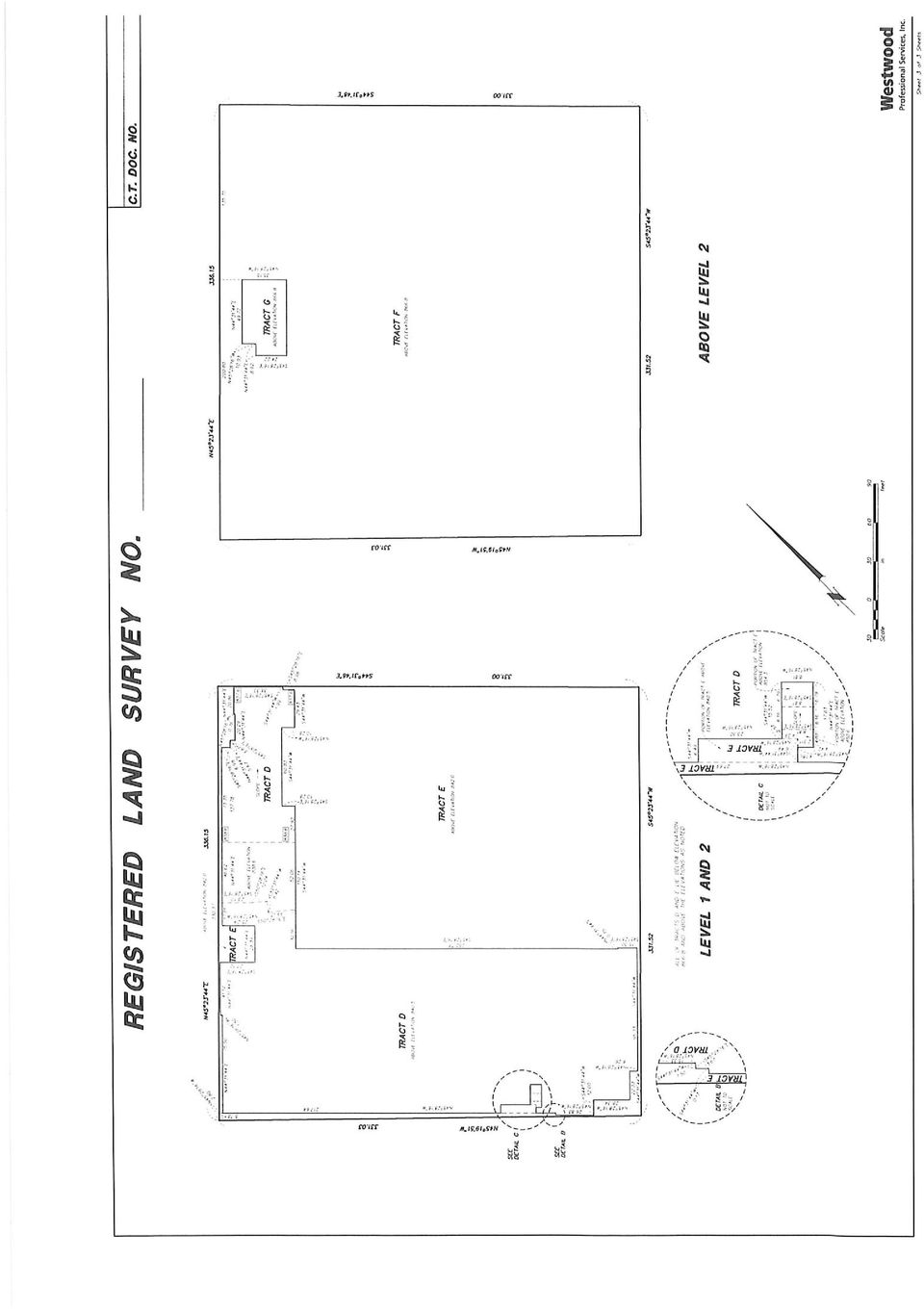
1 CPED STAFF REPORT Prepared for the City Planning Commission CPC Agenda Item #1 June 23, 2014 RLS-72 LAND USE APPLICATION SUMMARY Property Location: 222 Hennepin Avenue Project Name: 222 Prepared By: Becca Farrar-Hughes, Senior City Planner, (612) Applicant: Ryan Companies, US, Inc. Project Contact: Ryan Companies, US, Inc., Attn: Judy Hermanson Request: To separate the property both vertically as well as horizontally into independent tracts. Required Applications: Preliminary and Final Registered Land Survey To separate the property both vertically as well as horizontally into independent tracts for the Whole Foods Market and the 222 Hennepin Apartments. SITE DATA Existing Zoning B4S-2 District DP Overlay District Lot Area 110,499 square feet / 2.54 acres Ward(s) 3 Neighborhood(s) Designated Future Land Use Land Use Features Small Area Plan(s) North Loop Neighborhood Association; adjacent to Downtown Minneapolis Neighborhood Association Mixed-Use, and within the designated Downtown Growth Center The property has frontage on Washington Avenue North and on Hennepin Avenue which are designated Commercial Corridors. The site is also located within the designated Downtown Growth Center and just outside the Warehouse District Activity Center. North Loop Small Area Plan Date Application Deemed Complete April 25, 2014 Date Extension Letter Sent N/A End of 60-Day Decision Period N/A End of 120-Day Decision Period August 23, 2014

2 Department of Community Planning and Economic Development RLS-72 BACKGROUND SITE DESCRIPTION AND PRESENT USE. The full-block property located at 222 Hennepin Avenue was previously a vacant automobile dealership. In September of 2011, a site plan review application (BZZ-5237) was approved to allow a new mixed-use development that included 287 dwelling units and an approximately 45,000 square foot grocery store on the ground floor of the structure. The project was comprised of two interconnected, 6-story buildings with heights ranging from 35 to approximately 85 feet at the tallest point on the property. The development has been constructed and is now fully occupied. SURROUNDING PROPERTIES AND NEIGHBORHOOD. The site is surrounded by a mix of primarily commercial uses and parking. Gateway Park and the River Towers condominiums are located nearby to the east of the site. The ING/Reliastar complex is located directly across Hennepin Avenue from the site. A mix of surface and structured parking and low-rise buildings are located in the historic districts across 1st Avenue and 2nd Street. The Warehouse Historic District is located directly across 1st Avenue North from the site and the St. Anthony Falls Historic District is located directly across 2nd Street North. New construction is proposed and underway within the broader neighborhood. PROJECT DESCRIPTION. Ryan Companies US, Inc., has submitted an application for a Registered Land Survey (RLS) for the property located at 222 Hennepin Avenue. The purpose of the RLS is to separate the property both vertically as well as horizontally into independent tracts for the Whole Foods Market and the 222 Hennepin Apartments. The City Attorney and Public Works has reviewed and approved the final RLS title documents. RELATED APPROVALS. Planning Case # Application Description Action BZZ-5237 Site Plan Review A new mixed-use development Approved that included 287 dwelling units and an approximately 45,000 square foot grocery store on the ground floor of the structure. PUBLIC COMMENTS. Staff has not received official correspondence from the North Loop Neighborhood Association or any neighborhood letters prior to the printing of this report. Any correspondence received prior to the public meeting will be forwarded on to the Planning Commission for consideration. ANALYSIS PRELIMINARY/FINAL REGISTERED LAND SURVEY The Department of Community Planning and Economic Development has analyzed the application for a Preliminary and Final Plat based on the following findings: 1. The subdivision is in conformance with these land subdivision regulations, the applicable regulations of the zoning ordinance and policies of the comprehensive plan. The RLS is in conformance with the subdivision regulations, zoning code, and comprehensive plan. 2

3 Department of Community Planning and Economic Development RLS The subdivision will not be injurious to the use and enjoyment of other property in the immediate vicinity, nor be detrimental to present and potential surrounding land uses, nor add substantially to congestion in the public streets. The purpose of the RLS is to delineate ownership of various tracts on the site. This shall have no impact on surrounding properties. There is an approved TDMP for the site that ensures that the development provides adequate parking for the development and would not add unacceptable congestion to the public streets. 3. All land intended for building sites can be used safely without endangering the residents or users of the subdivision or the surrounding area because of flooding, erosion, high water table, soil conditions, improper drainage, steep slopes, rock formations, utility easements or other hazard. The building has been constructed and the site is fully occupied. The site does not pose the above noted hazards. 4. The lot arrangement is such that there will be no foreseeable difficulties, for reasons of topography or other conditions, in securing building permits and in providing driveway access to buildings on such lots from an approved street. Each lot created through subdivision is suitable in its natural state for the proposed use with minimal alteration. The building has been construction and the site is fully developed. Access is being provided in conjunction with the approved plan. 5. The subdivision makes adequate provision for stormwater runoff, and temporary and permanent erosion control in accordance with the rules, regulations and standards of the city engineer and the requirements of these land subdivision regulations. To the extent practicable, the amount of stormwater runoff from the site after development will not exceed the amount occurring prior to development. The existing utility and drainage provisions are adequate for the structure. Stormwater management and other applicable civil plans have been reviewed and approved by the City s Public Works Department. RECOMMENDATION Recommendation of the Department of Community Planning and Economic Development for the Registered Land Survey: The Department of Community Planning and Economic Development recommends that the City Planning Commission adopt the above findings and approve the Registered Land Survey application for the property located at 222 Hennepin Avenue. ATTACHMENTS 1. Written description and findings submitted by applicant 2. Correspondence from PW and City Attorney 3. Zoning map 4. Preliminary and Final RLS 5. Approved plans 3

4

5

6

7

8

9

10

11

12

13

14

15
16

17

18

19

20

21
22
PLANNED UNIT DEVELOPMENT & SIDEWALK WAIVER REQUEST STAFF REPORT Date: November 7, 2013
 PLANNED UNIT DEVELOPMENT & SIDEWALK WAIVER REQUEST STAFF REPORT Date: November 7, 2013 NAME LOCATION Audubon Properties, LLC. 4700 & 4960 Dauphin Island Parkway West side of Dauphin Island Parkway, 580
WESTFIELD-WASHINGTON ADVISORY PLAN COMMISSION December 7, 2015 1512-SPP-24 & 1512-ODP-24
 Petition Number: Subject Site Address: Petitioner: Request: East side of Oak Road, north of 151 st Street Langston Development Co. Primary Plat and Overall Development Plan amendment review for Mapleridge
ELEMENT 4 - FUTURE LAND USE ELEMENT
 ELEMENT 4 - FUTURE LAND USE ELEMENT Goal 1 To create a long-range development pattern which directs growth into developable areas and away from environmentally sensitive areas, in a manner that is compatible
Rezoning case no. RZ15-08: Adam Development Properties, LP
 PLANNING AND ZONING COMMISSION STAFF REPORT June 4, 2015 Rezoning case no. RZ15-08: Adam Development Properties, LP CASE DESCRIPTION: LOCATION: a request to amend the development plan of a previously-approved
City of Colleyville Community Development Department. Site/Landscape Plan Application Packet
 City of Colleyville Community Development Department Site/Landscape Plan Application Packet Development Application Fees City of Colleyville 100 Main Street Colleyville TX 76034 817.503.1050 Zoning Zoning
Washington City Subdivision Development Application Checklist 435-656-6325
 Application Checklist 1 Washington City Subdivision Development Application Checklist 435-656-6325 1) Wednesday Staff and Developer Meeting. *Call to schedule an appointment. A. Statement of project intent
SITE DEVELOPMENT PLAN CHECKLIST. Project Name: Site Plan No.:
 SITE DEVELOPMENT PLAN CHECKLIST 5/12/05 Rev.3/14/06 Project Name: Site Plan No.: REVIEW CRITERIA Plans: A site development plan (signed and sealed) shall be on a 24 x 36 sheet at a scale that is no smaller
Zoning Districts, Gwinnett County, Georgia
 Zoning Districts, Gwinnett County, Georgia The zoning district descriptions in this section should be used as a guide only for the unincorporated areas of Gwinnett County. Before buying or selling property,
CLACKAMAS COUNTY ZONING AND DEVELOPMENT ORDINANCE
 1008 STORM DRAINAGE (3/24/05) 1008.01 PURPOSE To minimize the amount of stormwater runoff resulting from development utilizing nonstructural controls where possible, maintain and improve water quality,
Article 20. Nonconformities
 Article 20. Nonconformities 20.1 PURPOSE 20.2 GENERAL STANDARDS OF APPLICABILITY 20.3 NONCONFORMING USE 20.4 NONCONFORMING STRUCTURES 20.5 NONCONFORMING LOTS OF RECORD 20.6 NONCONFORMING SIGNS 20.1 PURPOSE
Land Use and Zoning. Land Use Within the Port Madison Indian Reservation
 Land Use and Zoning Land Use Within the Port Madison Indian Reservation A portion of the Suquamish Rural Village is Trust land, owned either by the Tribe or individual tribal members. The following list
Planning Commission Staff Report
 10 Planning Commission Staff Report TO: FROM: THROUGH: PLANNING COMMISSION AMY TEMES, SENIOR PLANNER (480) 503-6729, [email protected] CATHERINE LORBEER, AICP, PRINCIPAL PLANNER (480) 503-6016 [email protected]
PC 23-11 Nate Lundgren-Auto Repair Business Conditional Use Permit 9/7/11 Applicants
 PC 23-11 Nate Lundgren-Auto Repair Business Conditional Use Permit 9/7/11 Applicants Nate Lundgren Triple K Partnership Mankato 105 LeSueur Ave 320 Mallard Lane Eagle Lake, MN 56024 Mankato MN 560001 Request
REGULATIONS FOR CELLULAR ANTENNA TOWERS AND CELLULAR TELECOMMUNICATIONS SERVICES
 REGULATIONS FOR CELLULAR ANTENNA TOWERS AND CELLULAR TELECOMMUNICATIONS SERVICES Joint City-County Planning Commission of Barren County, Kentucky 126 East Public Square City Hall Glasgow, KY 42141 A. PURPOSE:
ENGINEERING DESIGN GUIDELINES. for SUBDIVISIONS OR COMMERCIAL DEVELOPMENTS
 ENGINEERING DESIGN GUIDELINES for SUBDIVISIONS OR COMMERCIAL DEVELOPMENTS City of Birmingham Department of Planning, Engineering and Permits Engineering Division Office of the City Engineer 2008 TABLE
Model Subdivision and Land Development (SALDO) Subdivision/ Land Development Presentation Overview. Why Subdivision and Land Development Regulations?
 Subdivision/ Land Development Presentation Overview. Why Subdivision and Land Development Regulations?") Model Subdivision and Land Development (SALDO) Subdivision/ Land Development Presentation Overview Purpose of Subdivision/ Land Development Ordinances (SALDO) Municipalities Planning Code Process Design
Model Subdivision and Land Development (SALDO) Subdivision/ Land Development Presentation Overview Purpose of Subdivision/ Land Development Ordinances (SALDO) Municipalities Planning Code Process Design
NOTICE OF A TYPE Ix DECISION ON A PROPOSAL IN YOUR NEIGHBORHOOD
 Date: June 29, 2016 To: From: Interested Person Susan Ellis, Land Use Services 503-823-5361 / [email protected] NOTICE OF A TYPE Ix DECISION ON A PROPOSAL IN YOUR NEIGHBORHOOD The Bureau of
Floodplain Development Land Use Review
 COMMUNITY DEVELOPMENT DEPARTMENT Planning Division P.O. Box 490 333 Broadalbin Street SW Albany, OR 97321 Phone 541-917-7550 Fax 541-791-0150 www.cityofalbany.net Floodplain Development Land Use Review
STAFF REPORT PLANNING COMMISSION REGULAR MEETING OF OCTOBER 20, 2015. Debbie Hill, Associate Planner [email protected] 9386-A1
 STAFF REPORT PLANNING COMMISSION REGULAR MEETING OF OCTOBER 20, 2015 PREPARED BY: AGENDA ITEM & FILE NUMBER: PROJECT DESCRIPTION: PROJECT SIZE & LOCATION: GENERAL PLAN: ZONING: OWNER/APPLICANT: Debbie
Kirkland Zoning Code 113.25
 Kirkland Zoning Code 113.25 Chapter 113 COTTAGE, CARRIAGE AND TWO/THREE-UNIT HOMES Sections: 113.05 User Guide 113.10 Voluntary Provisions and Intent 113.15 Housing Types Defined 113.20 Applicable Use
CHAPTER 5 - "R1" SINGLE-FAMILY RESIDENTIAL DISTRICT
 CHAPTER 5 - "R1" SINGLE-FAMILY RESIDENTIAL DISTRICT Section 5-1. Regulations: The regulations set forth in this chapter, or set forth elsewhere in this ordinance when referred to in this chapter, are the
SITE PLAN REVIEW APPLICATION
 SITE PLAN REVIEW APPLICATION 405 Martin Luther King Jr. Blvd phone (919) 968-2728 fax (919) 969-2014 www.townofchapelhill.org Parcel Identifier Number (PIN): Date: Section A: Project Information Section
DALLAS COUNTY, IOWA CHAPTER 48 SMALL WIND ENERGY CONVERSION SYSTEMS ORDINANCE FOR THE UNINCOPORATED AREA OF DALLAS COUNTY, IOWA
 TITLE V PROPERTY AND LAND USE SMALL WIND ENERGY CONVERSION SYSTEMS ORDINANCE FOR THE UNINCOPORATED AREA OF DALLAS COUNTY, IOWA 48.01 INTENT 48.05 APPLICATION REQUIRED 48.02 DEFINITIONS 48.06 APPEALS 48.03
New Home Construction Packet
 New Home Construction Packet Congratulations! You are building a new home in Meyerland. This packet of information was assembled to assist you with the process. It contains all the forms that you will
The Metropolitan Planning Commission. DATE: May 19, 2015
 TO: FROM: The Metropolitan Planning Commission MPC Staff DATE: May 19, 2015 SUBJECT: Petition of LLC, Owner Harold Yellin, Agent PIN: 2-0015-01-002 & 003 Lot Size:.85 Acres (approximately) Aldermanic District:
PLANNING DIVISION STAFF REPORT February 23, 2015. Summary. Background Information PREPARED FOR THE PLAN COMMISSION. Legistar File ID # 36810
 PLANNING DIVISION STAFF REPORT PREPARED FOR THE PLAN COMMISSION Project Address: Application Type: Legistar File ID # 36810 Prepared By: Summary Conditional Use Timothy M. Parks, Planning Division Report
REZONING 16-000009 & PRELIMINARY PLAT 16-000005
 REZONING 16-000009 & PRELIMINARY PLAT 16-000005 REZONING REQUEST AND REVISED PRELIMINARY PLAT FOR THE BLUFFS AT WINDCASTLE - 4165 FAREDALE LANE Application: Engineer: Developer: Property Owner: Current
1. It would create hazardous effects of storm water run-off. 3. It would increase hazardous driving conditions on the public road.
 SECTION 6: REQUIREMENTS FOR A DRIVEWAY CONNECTION A. Required information. The application shall be accompanied by a sketch of the proposed driveway which at a minimum shall indicate: 1. Geometric information
FUTURE LAND USE ELEMENT
 GOALS, OBJECTIVES AND POLICIES FUTURE LAND USE ELEMENT GOAL A THE CITY OF FORT WALTON BEACH WILL PLAN FOR AND PROVIDE A HIGH QUALITY OF LIFE TO MEET THE NEEDS OF THE CURRENT AND FUTURE POPULATION, PROVIDING
Revere Beach Transit-Oriented Development Parcels Revere, Massachusetts. Design and Development Guidelines. Part Two.
 Revere Beach Transit-Oriented Development Parcels Revere, Massachusetts Design and Development Guidelines Request for Qualifications and Expressions of Interest with Preliminary Development Plans Part
Definition of Tower from the Bradley County Zoning Resolution
 Definition of Tower from the Bradley County Zoning Resolution 43. TOWER. Any outdoor structure designed and constructed to support one (1) or more transmitting or receiving devices for telephone, radio
INTRODUCTION TO ZONING DISTRICT REGULATIONS
 INTRODUCTION TO ZONING DISTRICT REGULATIONS Classification of Zoning Districts Zoning districts in Dorchester County are categorized as Suburban Urban, Suburban Transition, or Rural. These districts are
CITY OF SOMERVILLE, MASSACHUSETTS MAYOR S OFFICE OF STRATEGIC PLANNING & COMMUNITY DEVELOPMENT
 CITY OF SOMERVILLE, MASSACHUSETTS MAYOR S OFFICE OF STRATEGIC PLANNING & COMMUNITY DEVELOPMENT MICHAEL F. GLAVIN EXECUTIVE DIRECTOR JOSEPH A. CURTATONE MAYOR PLANNING DIVISION STAFF GEORGE PROAKIS, DIRECTOR
FILE NO.: Z-6915-C. Gamble Road Short-form PCD and Land Alteration Variance Request
 FILE NO.: Z-6915-C NAME: Gamble Road Short-form PCD and Land Alteration Variance Request LOCATION: Located on the Northwest corner of Chenal Parkway and Gamble Road DEVELOPER: Davis Properties P.O. Box
APPLICATION PROCESS FOR LAND DISTURBING PERMIT
 PREFACE: APPLICATION PROCESS FOR LAND DISTURBING PERMIT The property owner, developer and designated planners and engineers shall review the general development plans and detailed plans of the Local Issuing
Appendix N: Bicycle Parking Ordinance
 Appendix N: Bicycle Parking Ordinance ORDINANCE NO. #1-13. AN ORDINANCE AMENDING CHAPTER 40 OF THE MUNICIPAL CODE OF THE CITY OF DAVIS TO ADD ARTICLE 40.25A ESTABLISHING BICYCLE PARKING STANDARDS WHEREAS,
Division 51-4.400. Yard, Lot, and Space Regulations.
 Division 51-4.400. Yard, Lot, and Space Regulations. SEC. 51-4.401. MINIMUM FRONT YARD. (a) General provisions. (1) Required front yards must be open and unobstructed except for fences. Except as otherwise
Application No.: 14.074 Steve Rush, representing Rocky Mountain Power Rocky Mountain Power Project Location: approximately 1600 N. 6800 E.
 Planning Commission Staff Report Planning and Development Services Croydon Substation Conditional Use Permit Public Meeting August 28, 2014 Application No.: 14.074 Applicant: Steve Rush, representing Rocky
Site Development Information Worksheet for single family residential development
 Site Development Information Worksheet for single family residential development Project description: Address: Owner Name: Phone No. Date Signature & phone number of Individual who Completed this Worksheet
Neighborhood Planning Guide To Zoning
 City of Austin Neighborhood Planning Guide To Zoning City of Austin Planning & Development Review Department 505 Barton Springs Road One Texas Center Austin, TX 78704 June 2014 DISCLAIMER: This Guide is
CHECKLIST FOR ESTABLISHING A DAY CARE CENTER (Revised 10-23-2014)
") Newton County Department of Development Services CHECKLIST FOR ESTABLISHING A DAY CARE CENTER (Revised 10-23-2014) DEFINITIONS Day Care Center, Adult. An establishment operated by any person with or without
Newton County Department of Development Services CHECKLIST FOR ESTABLISHING A DAY CARE CENTER (Revised 10-23-2014) DEFINITIONS Day Care Center, Adult. An establishment operated by any person with or without
2229-2245 Kingston Rd Removal of a Holding Provision (H) Application Final Report
 Application Final Report") STAFF REPORT ACTION REQUIRED 2229-2245 Kingston Rd Removal of a Holding Provision (H) Application Final Report Date: May 29, 2015 To: From: Wards: Reference Number: Scarborough Community Council Director,
STAFF REPORT ACTION REQUIRED 2229-2245 Kingston Rd Removal of a Holding Provision (H) Application Final Report Date: May 29, 2015 To: From: Wards: Reference Number: Scarborough Community Council Director,
HIGHWAY DEPARTMENT ACCESS AND RIGHT OF WAY WIDTH GUIDELINES
 Approved 6/26/01 HIGHWAY DEPARTMENT ACCESS AND RIGHT OF WAY WIDTH GUIDELINES All new, modified and/or changed use access(es) onto county roads shall be subject to the access and corridor protection guidelines
City Code of ANN ARBOR, MICHIGAN Chapter 55 Zoning
 ARTICLE II. USE REGULATIONS 5:10.2. R1A, R1B, R1C, R1D single family dwelling district (1) Intent. (a) These single family residential districts are designed to provide an environment of predominantly
City of Edgewood REQUEST FOR QUALIFICATIONS 2016 ON-CALL CONSULTANT SERVICES
 City of Edgewood REQUEST FOR QUALIFICATIONS 2016 ON-CALL CONSULTANT SERVICES I. PURPOSE OF REQUEST. The City of Edgewood is requesting statements of qualifications from professional consulting firms licensed
TOWN OF CARY CONDITIONAL USE ZONING PERMIT. 412 Rutherglen Cary, NC 27511-6437. 412 Rutherglen Cary, NC 27511-6437
 TOWN OF CARY CONDITIONAL USE ZONING PERMIT PETITION: PETITIONER(S): OWNER(S): LOCATION: 01-REZ-16 204 N. Dixon Avenue, Cary, NC PARCEL IDENTIFICATION: 076418218784 REALID: 0031004 AREA: APPROVED ZONING:
Draft ARTICLE 20A "AO" ANTIETAM OVERLAY DISTRICT
 Draft ARTICLE 20A "AO" ANTIETAM OVERLAY DISTRICT Section 20A.0 Purpose The purpose of the Antietam Overlay District is to provide mechanisms for the protection of significant historic structures and land
STAFF REPORT. December 20, 2004. North District Community Council. Director of Community Planning - North
 STAFF REPORT December 20, 2004 To: From: Subject: North District Community Council Director of Community Planning - North Preliminary Report Respecting Revised Application OPA & Rezoning Application 01
sdci Seattle Permits Tip Tree Protection Regulations in Seattle CATEGORIES OF TREES AFFECTED IDENTIFYING TREE TYPES ON YOUR PROPERTY
 sdci Seattle Department of Construction and Inspections Tip 242 Seattle Permits part of a multi-departmental City of Seattle series on getting a permit Updated May 12, 2011 Tree Protection Regulations
5.14 Floodplains and Drainage/Hydrology
 I-70 East Final EIS 5.14 Floodplains and Drainage/Hydrology 5.14 Floodplains and Drainage/Hydrology This section discusses floodplain and drainage/hydrology resources and explains why they are important
CITY OF GLOUCESTER PLANNING BOARD MEETING MINUTES DECEMBER 20, 2012 7:00 P.M.
 CITY OF GLOUCESTER PLANNING BOARD MEETING MINUTES DECEMBER 20, 2012 7:00 P.M. Kyrouz Auditorium, City Hall, 9 Dale Avenue, Gloucester Richard Noonan, Chair Members Present: Rick Noonan, Chair, Mary Black,
APPENDIX I DEVELOPMENT PROCESS CHECKLIST
 APPENDIX I DEVELOPMENT PROCESS CHECKLIST Bureau of Indian Affairs, Western Regional Office 400 N. 5 th St., Two AZ Center/Phoenix, AZ 85004/Telephone/website PRE-DEVELOPMENT PROCESS CHECKLIST This checklist
ORDINANCE NO. 2013 -
 ORDINANCE NO. 2013 - AN ORDINANCE OF BREVARD COUNTY, FLORIDA AMENDING CHAPTER 62, LAND DEVELOPMENT REGULATIONS SECTION 62-2891, LOT DRAINAGE, AND CHAPTER 22 BUILDINGS AND BUILDING REGULATIONS, SECTION
The Bond Release Process for New Subdivision Developments: An Overview for Homeowners Associations DRAFT 6-4-08. Revised 9-25-08
 The Bond Release Process for New Subdivision Developments: An Overview for Homeowners Associations DRAFT 6-4-08. Revised 9-25-08 Fairfax County requires developers to post a performance bond if they are
Architectural Processing and Inspections for Home Mortgage Insurance
 Page 1 of 5 [Text Only] Architectural Processing and Inspections for Home Mortgage Insurance Directive Number: 4145.1 SITE GRADING AND DRAINAGE GUIDELINES Construction complaints and structural defect
CHAPTER 3 MANUFACTURED AND MOBILE HOMES
 16-3-1 HOT SPRINGS CODE 16-3-3 CHAPTER 3 16-3-1. Short title. This ordinance may be referred to as the Hot Springs Manufactured Home Ordinance. 16-3-2. Definitions. For the purpose of this ordinance, the
Churches and Schools Development Standards
 Uses Code Provisions Site Development Standards RS-4 Sec.24-44 RD Sec. 24-45 RM-23 Sec. 24-48 Residential Single Family Residential Two- Family (Duplex) Residential Mid- Rise Multifamily (High Density)
3 September 9, 2015 Public Hearing
 3 September 9, 2015 Public Hearing APPLICANT: PI TELECOM INFRASTRUCTURE T, LLC PROPERTY OWNER: JSW HOLDINGS, LLC STAFF PLANNER: Carolyn A.K. Smith REQUEST: Conditional Use Permit (communications tower-monopole)
THIS PAGE INTENTIONALLY LEFT BLANK
 Z-60 (2014) Z-60 (2014) THIS PAGE INTENTIONALLY LEFT BLANK APPLICANT: West Cobb Senior Living, LLC PETITION NO: Z-60 PHONE#: (770) 422-7016 EMAIL: [email protected] HEARING DATE (PC): 09-4-14 REPRESENTATIVE:
FOR SALE. The Friedman Building 1701 18th Avenue South, Seattle 98144. Nicholas T. Gill 206.505.9410. Allan Friedman. 206.505.
 FOR SALE FOR MORE INFORMATION PLEASE CONTACT: The Friedman Building 1701 18th Avenue South, Seattle 98144 PRICE: $4,800,000 FEATURES: LAND SF: 40,000 SF + Fantastic Large Townhome Site BUILDING SF: 33,332
PINELLAS COUNTY COMPREHENSIVE PLAN
 PINELLAS COUNTY COMPREHENSIVE PLAN Future Land Use Map (FLUM) Category Descriptions and Rules Amended March 17, 2009 (Ordinance 09-17) Amended March 16, 2010 (Ordinance 10-18) Amended October 26, 2010
City Council Agenda Item Report October 13, 2015
 City Council Agenda Item Report October 13, 2015 Contact Chance Sparks, AICP, CNU-A, Director of Planning 512-312-0084 / [email protected] SUBJECT: APPROVAL OF A PRELIMINARY PLAN FOR THE BUDA BUSINESS
Land Disturbance, Erosion Control and Stormwater Management Checklist. Walworth County Land Conservation Department
 Land Disturbance, Erosion Control and Stormwater Management Checklist Walworth County Land Conservation Department The following checklist is designed to assist the applicant in complying with the Walworth
Chapter 3 SENSITIVE AREAS AND VEGETATED CORRIDORS
 Chapter 3 3.01 General Provisions 3.01.1 Introduction 3.01.2 Application and Interpretation of Chapter 3.01.3 Unbuildable Lots 3.01.4 Other Permits 3.01.5 Prohibited Activities 3.02 Service Provider Letter
ARTICLE 22. AKB ARTHUR K. BOLTON PARKWAY OVERLAY ZONE
 ARTICLE 22. AKB ARTHUR K. BOLTON PARKWAY OVERLAY ZONE Sec. 2201. Purpose. AKB is an overlay zone which governs the development of property located along the Arthur K. Bolton Parkway (Georgia Highway 16
PROPERTY LINE ADJUSTMENT APPLICATION
 PROPERTY LINE ADJUSTMENT APPLICATION City of Klamath Falls Planning Division 226 S. 5 th St. / P.O. Box 237, Klamath Falls, OR 97601 File No. A property line adjustment is required any time an adjustment
1161.01 CONFORMITY WITH PLANS; DRAINAGE.
 CHAPTER 1161 Subdivision Requirements 1161.01 Conformity with plans; drainage 1161.07 Easements 1161.02 Trees 1161.08 Streets 1161.03 Subdivision name 1161.09 Blocks 1161.04 Street names 1161.10 Lots 1161.05
Scenario Planning Report. Austin South Shore Central
 View of Downtown Austin from South Shore s Statesman site. Introduction Austin s South Shore Central Sub-District South Shore Central is an 88-acre sub-district of the waterfront overlay. As a fairly auto-oriented
TOWN OF WHITBY REPORT RECOMMENDATION REPORT
 TOWN OF WHITBY REPORT RECOMMENDATION REPORT REPORT TO: Planning and Development Committee REPORT NO: PL-80-10 DATE OF MEETING: June 14, 2010 FILE NO(S): OPA-2010-W/03 & Z-12-10 PREPARED BY: Planning Department
FLOOD PROTECTION BENEFITS
 IV. (340 points) Flood Protection Benefits A. Existing and potential urban development in the floodplain (50) 1. Describe the existing and potential urban development at the site and the nature of the
3655 Kingston Rd - Official Plan and Zoning By-law Amendment Applications - Preliminary Report
 STAFF REPORT ACTION REQUIRED 3655 Kingston Rd - Official Plan and Zoning By-law Amendment Applications - Preliminary Report Date: January 13, 2016 To: From: Wards: Reference Number: Scarborough Community
PRELIMINARY PROJECT REVIEW PROCESS
 CITY OF CYPRESS 5275 Orange Avenue Cypress, California 90630 (714) 229-6720 PRELIMINARY PROJECT REVIEW PROCESS 1. Discuss project with Planning staff to determine zoning regulations, unusual characteristics
PREDEVELOPMENT PLAN REVIEW OF ART CENTER COLLEGE OF DESIGN MASTER PLAN
 TO: FROM: SUBJECT: Honorable Mayor and City Council Planning & Community Development Department PREDEVELOPMENT PLAN REVIEW OF ART CENTER COLLEGE OF DESIGN MASTER PLAN RECOMMENDATION: This report is for
CITY COUNCIL / PLANNING COMMISSION JOINT STUDY SESSION AGENDA REPORT
 CITY COUNCIL / PLANNING COMMISSION JOINT STUDY SESSION AGENDA REPORT MEETING DATE: SEPTEMBER 8, 2015 ITEM NUMBER: 1 SUBJECT: PROPOSED GENERAL PLAN LAND USE ALTERNATIVE FOR THE YEAR 2015-2025 GENERAL PLAN
Answers to Commonly Asked Questions
 County of San Diego, Planning & Development Services FIRESTORM POLICY AND GUIDANCE DOCUMENT BUILDING DIVISION Answers to Commonly Asked Questions The County of San Diego understands the confusion and frustration
CITY OF WEST PALM BEACH PLANNING BOARD Meeting Date: August 20, 2013 Planning Board Case No. 1564C
 CITY OF WEST PALM BEACH PLANNING BOARD Meeting Date: August 20, 2013 Planning Board Case No. 1564C Rezoning from Community Service (CS) to Community Service Planned Development (CSPD) Hanley Center 5200
UPPER MILFORD TOWNSHIP: ZONING HEARING BOARD A GUIDE FOR USE BY RESIDENTS
 UPPER MILFORD TOWNSHIP: ZONING HEARING BOARD A GUIDE FOR USE BY RESIDENTS PROCEDURES Residents are required to complete an Application Form for a Building/Use Permit which are available at the Township
MAPPING MINNEAPOLIS URBAN TREE CANOPY. Why is Tree Canopy Important? Project Background. Mapping Minneapolis Urban Tree Canopy.
 MAPPING MINNEAPOLIS URBAN TREE CANOPY Why is Tree Canopy Important? Trees are an important component of urban environments. In addition to their aesthetic value, trees have significant economic and environmental
MOBILE HOME LAW. Revised November 2001
 MOBILE HOME LAW Revised November 2001 TABLE OF CONTENTS: SECTION 1: SECTION 2: SECTION 3: SECTION 4: SECTION 5: SECTION 6: SECTION 7: SECTION 8: SECTION 9: SECTION 10: SECTION 11: SECTION 12: INTENT DEFINITIONS
WEST MISSION AVENUE SPECIFIC PLAN (Council Approved 11/5/03 - Resolution 2003-166-R)
") WEST MISSION AVENUE SPECIFIC PLAN (Council Approved 11/5/03 - Resolution 2003-166-R) Section 1. Purpose and Intent The goal of the West Mission Specific Plan is to facilitate the revitalization efforts
WEST MISSION AVENUE SPECIFIC PLAN (Council Approved 11/5/03 - Resolution 2003-166-R) Section 1. Purpose and Intent The goal of the West Mission Specific Plan is to facilitate the revitalization efforts
TOWN OF DAVIE TOWN COUNCIL AGENDA REPORT
 TOWN OF DAVIE TOWN COUNCIL AGENDA REPORT TO: Mayor and Councilmembers FROM/PHONE: Mark Kutney, AICP, Development Services Director/(954) 797-1101 Prepared by Annie Feng, Planner II SUBJECT: Resolution
City of Valdosta Land Development Regulations. Table of Contents
 TITLE 1 ADMINISTRATION Chapter 102 General Provisions 102-1 Title 102-2 Purpose 102-3 Authority 102-4 Jurisdiction 102-5 Application of Ordinance 102-6 Relationship to Existing Ordinances 102-7 Powers
City of Tampa Zoning Districts
 City of Tampa Zoning Districts The city is divided by chapter 2 into zoning districts, the boundaries and designations of which are shown in a series of maps, covering in combination the entire land and
CITY OF NORMANDY PARK MANHATTAN VILLAGE REDEVELOPMENT AREA STRATEGY AND CONCEPTUAL MASTER PLAN
 CITY OF NORMANDY PARK MANHATTAN VILLAGE REDEVELOPMENT AREA STRATEGY AND CONCEPTUAL MASTER PLAN Project Purpose The City of Normandy Park is studying ways to help property owners in the Manhattan Village
COASTAL DEVELOPMENT PERMIT
 COASTAL DEVELOPMENT PERMIT ZONE CODE SECTIONS 12.20.2 prior to LCP certification. The MASTER LAND USE APPLICATION INSTRUCTION SHEET 500' RADIUS should also be followed, except that a 100-foot radius map
SECTION 5 RESIDENTIAL R1 ZONE
 SECTION 5 RESIDENTIAL R1 ZONE 5.1 GENERAL PURPOSE OF THE R1 ZONE The R1 Zone is the most restrictive residential zone, and provides for and regulates single detached dwellings. The zone variations are
City of Sugar Hill Planning Staff Report AX 15-004
 City of Sugar Hill Planning Staff Report AX 15-4 DATE: TO: FROM: SUBJECT: September 3, 215 Mayor & Council Planning Director \cj.r Annexation Request AX 15-4 I 568, 5722 & 5872 Suwanee Dam Road Tax Parcel
RESIDENTIAL BUILDING PERMIT REQUIREMENTS
 RESIDENTIAL BUILDING PERMIT REQUIREMENTS The Building Inspection Division has compiled this packet to help our customers obtain a Building Permit. Enclosed we have listed all departments and inspection
The checklist utilized by the Authority will be similar to that which is shown below. Project Name: Location: Consulting Engineering Firm:
 Page 1 of 6 Section 1. PURPOSE This policy is an Engineering checklist of the Local Review Program for sanitary sewer improvement projects by the Bedford Regional Water Authority ( Authority ). Section
Staff Report General Development Plan/Master Plan Aldermanic District: 1 County Commission District: 2 MPC File No. 16-000526-PLAN February 23, 2016
 Staff Report General Development Plan/Master Plan Aldermanic District: 1 County Commission District: 2 MPC File No. 16-000526-PLAN February 23, 2016 1101 Bull Street One West Park Avenue 1107 Bull Street
CITY OF VAUGHAN SCHEDULE O LOT GRADING DESIGN FOR RESIDENTIAL DEVELOPMENT
 Page 1 CITY OF VAUGHAN SCHEDULE O LOT GRADING DESIGN FOR RESIDENTIAL DEVELOPMENT CIVIC CENTRE 2141 MAJOR MACKENZIE DRIVE MAPLE ONTARIO L6A 1T1 905-832-2281 Page 2 SECTION 1 - GENERAL OBJECTIVES To provide
Adopted 9/23/98 CHATTAHOOCHEE CORRIDOR PLAN. The goals of the Chattahoochee Corridor Plan (hereinafter also referred to as the Plan ) are:
 are:") CHATTAHOOCHEE CORRIDOR PLAN Adopted 9/23/98 PART 1: GOALS. POLICY. COVERAGE. A. Goals The goals of the Chattahoochee Corridor Plan (hereinafter also referred to as the Plan ) are: 1. Preservation and protection
CHATTAHOOCHEE CORRIDOR PLAN Adopted 9/23/98 PART 1: GOALS. POLICY. COVERAGE. A. Goals The goals of the Chattahoochee Corridor Plan (hereinafter also referred to as the Plan ) are: 1. Preservation and protection
FLOOD DAMAGE PREVENTION ORDINANCE
 FLOOD DAMAGE PREVENTION ORDINANCE SECTION 1.0 STATUTORY AUTHORIZATION, FINDINGS FO FACT, PURPOSE, AND OBJECTIVES 1.1 STATUTORY AUTHORIZATION The Legislature of the State of Washington has in RCW delegated
Preliminary Plan Application and Checklist
 ALL APPLICATIONS ARE DUE AT 12:00 NOON ON THE FILING DATE Office Use Only PRELIMINARY / REVISED PRELIMINARY PLAN $300.00 Fee Paid: $ Date Paid: ALL FIELDS HIGHLIGHTED IN RED ARE REQUIRED FIELDS Case No.: