Towards agreed data quality layers for airborne hyperspectral imagery
|
|
|
- Gary Harrington
- 8 years ago
- Views:
Transcription
1 Towards agreed data quality layers for airborne hyperspectral imagery M. Bachmann, DLR M. Bachmann, DLR, S. Adar, TAU; E. Ben-Dor, TAU; J. Biesemans, VITO; X. Briottet, ONERA; M. Grant, PML; J. Hanus, USBE; S. Holzwarth, DLR; A. Hueni, UZH; M. Kneubuehler, UZH; K. Meuleman, VITO; E. de Miguel, INTA; I. Perez Gonzalez, INTA; I. Reusen, VITO; R. Richter, DLR; T. Ruhtz, FUB; M. Schaale, FUB 7th EARSeL SIG Imaging Spectroscopy workshop Edinburgh, April 2011

2 EUFAR Joint Research Activity JRA2 Research objective: To develop quality indicators and quality layers for airborne hyperspectral imagery All major PAFs for airborne hyperspectral data in Europe included: PML/NERC, INTA, VITO/RSL, DLR, USBE, TAU, FUB (ONERA associated) Previous tasks within JRA2: Uncertainty estimation of various pre-processing steps Questionnaire for the selection of generic Quality Indicators What's new: Recommendation on algorithms Harmonization of QI design Implementation in PAFs Folie 2

3 Aim: Provision of Quality Layers and Reports operationally for every processed dataset in standardized, harmonized and user-friendly way Example: DLR s Quality Layers in ENVI Folie 3

4 Agreed common algorithms for Quality Layers Aggregated interpolated pixel mask Aggregated bad pixel mask ( not corrected ) Saturated pixel / overflow Problems with position / attitude Interpolated position / attitude Cloud mask Cloud shadow mask Haze mask Critical local viewing and illumination geometry. additional PAF-specific layers All documented in ATBD EUFAR DJ2.2.2 & Folie 4

5 Extended Metadata ( Data Descriptors ) General INSPIRE / ISO metadata: Provider and contact information (Laboratory) Calibration information Processing information Also includes information on data quality, e.g. Confidence in atmospheric correction from model itself (e.g., number of DDV pixels) Aerosol optical thickness, WaterVapor content Information on DEM (e.g. resolution, accuracy, ) used for processing Folie 5
 used for processing Folie 5")
6 Harmonization VITO / RSL implementation in HDF5 DLR implementation in HDF5 Folie 6

7 Inclusion of QC into PAF workflow AHS aux files L0 image SBET MarkerBit (POE gaps) Implementation of QC procedures in automated processing workflows using agreed approaches QL(3) saturated pix AHS_Rencpy POE tool PARGE QL(4,5) position problem attitude problem DEM angles scan angles Therefore the same set of QL with every dataset from EUFAR PAFs QL(1) radiance < 0 A3 ATCOR4 Software testing & validation currently in progress QL(6) Cloud mask Data descriptors Example: INTA AHS processing Folie 7
 Cloud mask Data descriptors Example: INTA")
8 Inclusion of QC into PAF workflow Implementation of QC procedures in automated processing workflows using agreed approaches QL(3) saturated pix QL(4,5) position problem attitude problem Therefore the same set of QL with every dataset from EUFAR PAFs QL(1) radiance < 0 Software testing & validation currently in progress QL(6) Cloud mask Data descriptors Example: INTA AHS processing Folie 8
 Cloud mask Data descriptors Example: INTA AHS")
9 Inclusion of QC into PAF workflow QL(4,5) position problem attitude problem QL(3) saturated pix QL(1) radiance < 0 QL(6) Cloud mask Data descriptors Example: INTA AHS processing Example: L1 SW DLR Folie 9

10 Common approaches establishing standards HyMap high altitude scene (15km AGL), truecolor RGB, provided by HyVista Folie 10

11 Common approaches establishing standards HyMap high altitude scene (15km AGL), truecolor RGB, provided by HyVista Wide FOV (~60 ) Folie 11

12 Common approaches establishing standards HyMap high altitude scene (15km AGL), truecolor RGB, provided by HyVista Quality Layer: cloud mask Quality Layer: cloud mask Results from common approach for L2 (Richter 2010, see EUFAR DJ222) Folie 12
 Folie")
13 Common approaches establishing standards HyMap high altitude scene (15km AGL), truecolor RGB, provided by HyVista Cloud mask Comparison of L1 mask (blue, foreground) and L2 mask (yellow, background) Folie 13
 and L2 mask (yellow, background) Folie")
14 Common approaches establishing standards HyMap high altitude scene (15km AGL), truecolor RGB, provided by HyVista Quality Layer: cloud shadow mask Results from common approach for L2 (Richter 2010, see EUFAR DJ222) Folie 14
")
15 Common approaches establishing standards HyMap high altitude scene (15km AGL), truecolor RGB, provided by HyVista Cloud shadow mask Comparison of common approach (red) with interactive digitizing (green) Limitations of automated processing R&D for processing chains Folie 15
 Limitations of automated processing R&D for processing")
16 Common approaches establishing standards Quality Layer: critical local viewing and illumination geometry Provision of complete information: View zenith & azimuth angle Solar zenith & azimuth angle Local illumination angle Sky view factor Therefore: User can decide which BRDF geometry is critical for a specific application Advanced surface-dependent BRDF models can easily be applied Example: VITO PAF Folie 16

17 Outlook and Next Steps Extension of Quality DLR and other PAFs For EnMAP, for ESA CCI Burnt Area (MERIS, (A)ATSR, ) Development of additional Quality Indicators Continuity of hyperspectral JRA within next EUFAR Again, all PAFs involved in order to guarantee European dimension Folie 17

18 Thank you for your attention! For references & ATBDs see

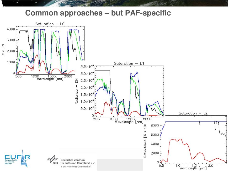
19 Common approaches but PAF-specific Folie 19

20 Folie 20

21 Folie 21
22 Folie 22
Data Processing Developments at DFD/DLR. Stefanie Holzwarth Martin Bachmann, Rudolf Richter, Martin Habermeyer, Derek Rogge
 Data Processing Developments at DFD/DLR Stefanie Holzwarth Martin Bachmann, Rudolf Richter, Martin Habermeyer, Derek Rogge EUFAR Joint Expert Working Group Meeting Edinburgh, April 14th 2011 Conclusions
EUFAR2 Expert Working Group meeting: Airborne Laser Scanning Software. 20 th to 21 st of November 2014 TU Vienna, Austria
 EUFAR2 Expert Working Group meeting: Airborne Laser Scanning Software 20 th to 21 st of November 2014 TU Vienna, Austria TABLE OF CONTENTS ACRONYMS & ABBREVIATIONS... 3 LIST OF PARTICIPANTS (confirmed)...
Measurement of the effect of biomass burning aerosol on inhibition of cloud formation over the Amazon
 Supporting Online Material for Koren et al. Measurement of the effect of biomass burning aerosol on inhibition of cloud formation over the Amazon 1. MODIS new cloud detection algorithm The operational
MOD09 (Surface Reflectance) User s Guide
 User s Guide") MOD09 (Surface ) User s Guide MODIS Land Surface Science Computing Facility Principal Investigator: Dr. Eric F. Vermote Web site: http://modis-sr.ltdri.org Correspondence e-mail address: mod09@ltdri.org
MOD09 (Surface ) User s Guide MODIS Land Surface Science Computing Facility Principal Investigator: Dr. Eric F. Vermote Web site: http://modis-sr.ltdri.org Correspondence e-mail address: mod09@ltdri.org
Realization of a UV fisheye hyperspectral camera
 Realization of a UV fisheye hyperspectral camera Valentina Caricato, Andrea Egidi, Marco Pisani and Massimo Zucco, INRIM Outline Purpose of the instrument Required specs Hyperspectral technique Optical
VIIRS-CrIS mapping. NWP SAF AAPP VIIRS-CrIS Mapping
 NWP SAF AAPP VIIRS-CrIS Mapping This documentation was developed within the context of the EUMETSAT Satellite Application Facility on Numerical Weather Prediction (NWP SAF), under the Cooperation Agreement
GOES-R AWG Cloud Team: ABI Cloud Height
 GOES-R AWG Cloud Team: ABI Cloud Height June 8, 2010 Presented By: Andrew Heidinger 1 1 NOAA/NESDIS/STAR 1 Outline Executive Summary Algorithm Description ADEB and IV&V Response Summary Requirements Specification
Multiangle cloud remote sensing from
 Multiangle cloud remote sensing from POLDER3/PARASOL Cloud phase, optical thickness and albedo F. Parol, J. Riedi, S. Zeng, C. Vanbauce, N. Ferlay, F. Thieuleux, L.C. Labonnote and C. Cornet Laboratoire
Lectures Remote Sensing
 Lectures Remote Sensing ATMOSPHERIC CORRECTION dr.ir. Jan Clevers Centre of Geo-Information Environmental Sciences Wageningen UR Atmospheric Correction of Optical RS Data Background When needed? Model
Data Processing Flow Chart
 Legend Start V1 V2 V3 Completed Version 2 Completion date Data Processing Flow Chart Data: Download a) AVHRR: 1981-1999 b) MODIS:2000-2010 c) SPOT : 1998-2002 No Progressing Started Did not start 03/12/12
INTA AIRBORNE REMOTE SENSING FACILITY from the Hasselblad s cameras to the SensyTech-AHS sensor
 INTA AIRBORNE REMOTE SENSING FACILITY from the Hasselblad s cameras to the SensyTech-AHS sensor José-Antonio Gómez-Sánchez gomezsj@inta.es Remote Sensing Laboratory INSTITUTO NACIONAL DE TÉCNICA AEROESPACIAL
Files Used in this Tutorial
 Generate Point Clouds Tutorial This tutorial shows how to generate point clouds from IKONOS satellite stereo imagery. You will view the point clouds in the ENVI LiDAR Viewer. The estimated time to complete
Data processing (3) Cloud and Aerosol Imager (CAI)
 Cloud and Aerosol Imager (CAI)") Data processing (3) Cloud and Aerosol Imager (CAI) 1) Nobuyuki Kikuchi, 2) Haruma Ishida, 2) Takashi Nakajima, 3) Satoru Fukuda, 3) Nick Schutgens, 3) Teruyuki Nakajima 1) National Institute for Environmental
Data processing (3) Cloud and Aerosol Imager (CAI) 1) Nobuyuki Kikuchi, 2) Haruma Ishida, 2) Takashi Nakajima, 3) Satoru Fukuda, 3) Nick Schutgens, 3) Teruyuki Nakajima 1) National Institute for Environmental
CROP CLASSIFICATION WITH HYPERSPECTRAL DATA OF THE HYMAP SENSOR USING DIFFERENT FEATURE EXTRACTION TECHNIQUES
 Proceedings of the 2 nd Workshop of the EARSeL SIG on Land Use and Land Cover CROP CLASSIFICATION WITH HYPERSPECTRAL DATA OF THE HYMAP SENSOR USING DIFFERENT FEATURE EXTRACTION TECHNIQUES Sebastian Mader
Generation of Cloud-free Imagery Using Landsat-8
 Generation of Cloud-free Imagery Using Landsat-8 Byeonghee Kim 1, Youkyung Han 2, Yonghyun Kim 3, Yongil Kim 4 Department of Civil and Environmental Engineering, Seoul National University (SNU), Seoul,
Sharing field spectroscopy data within large data sharing systems
 GSR_3 Geospatial Science Research 3. School of Mathematical and Geospatial Science, RMIT University December 2014 Sharing field spectroscopy data within large data sharing systems Barbara Rasaiah, Simon
The Airborne Imaging Spectrometer APEX (Airborne Prism EXperiment)
") The Airborne Imaging Spectrometer APEX (Airborne Prism EXperiment) The APEX Team: Klaus Itten, Michael Schaepman, Daniel Schläpfer, Johannes W. Kaiser, Jason Brazile (RSL) Walter Debruyn, Koen Meuleman,
The Airborne Imaging Spectrometer APEX (Airborne Prism EXperiment) The APEX Team: Klaus Itten, Michael Schaepman, Daniel Schläpfer, Johannes W. Kaiser, Jason Brazile (RSL) Walter Debruyn, Koen Meuleman,
27/01/2014. Workflows for Remote Sensing Data Processing: Software Development Strategy & Designing Operational Scenarios
 27/01/2014 Workflows for Remote Sensing Data Processing: Software Development Strategy & Designing Operational Scenarios SW Development strategy Life cycle model Project-driven evolutionary life-cycle
Cloud detection and clearing for the MOPITT instrument
 Cloud detection and clearing for the MOPITT instrument Juying Warner, John Gille, David P. Edwards and Paul Bailey National Center for Atmospheric Research, Boulder, Colorado ABSTRACT The Measurement Of
SEMI-AUTOMATED CLOUD/SHADOW REMOVAL AND LAND COVER CHANGE DETECTION USING SATELLITE IMAGERY
 SEMI-AUTOMATED CLOUD/SHADOW REMOVAL AND LAND COVER CHANGE DETECTION USING SATELLITE IMAGERY A. K. Sah a, *, B. P. Sah a, K. Honji a, N. Kubo a, S. Senthil a a PASCO Corporation, 1-1-2 Higashiyama, Meguro-ku,
Assessing Cloud Spatial and Vertical Distribution with Infrared Cloud Analyzer
 Assessing Cloud Spatial and Vertical Distribution with Infrared Cloud Analyzer I. Genkova and C. N. Long Pacific Northwest National Laboratory Richland, Washington T. Besnard ATMOS SARL Le Mans, France
Information Contents of High Resolution Satellite Images
 Information Contents of High Resolution Satellite Images H. Topan, G. Büyüksalih Zonguldak Karelmas University K. Jacobsen University of Hannover, Germany Keywords: satellite images, mapping, resolution,
ENVI THE PREMIER SOFTWARE FOR EXTRACTING INFORMATION FROM GEOSPATIAL IMAGERY.
 ENVI THE PREMIER SOFTWARE FOR EXTRACTING INFORMATION FROM GEOSPATIAL IMAGERY. ENVI Imagery Becomes Knowledge ENVI software uses proven scientific methods and automated processes to help you turn geospatial
EO data hosting and processing core capabilities and emerging solutions
 EO data hosting and processing core capabilities and emerging solutions Andrew Groom 4 th March 2015 Contents An introduction to Airbus Defence and Space, Geo-Intelligence Elements of the C3S vision EO
CrIS L1B Project Status
 CrIS L1B Project Status Graeme Martin 1, Hank Revercomb 1, Larrabee Strow 2, Dave Tobin 1, Howard Moteller 2, Liam Gumley 1, Ray Garcia 1, Greg Quinn 1, Joe Taylor 1, Coda Phillips 1, Bob Knuteson 1, Jessica
STAR Algorithm and Data Products (ADP) Beta Review. Suomi NPP Surface Reflectance IP ARP Product
 Beta Review. Suomi NPP Surface Reflectance IP ARP Product") STAR Algorithm and Data Products (ADP) Beta Review Suomi NPP Surface Reflectance IP ARP Product Alexei Lyapustin Surface Reflectance Cal Val Team 11/26/2012 STAR ADP Surface Reflectance ARP Team Member
STAR Algorithm and Data Products (ADP) Beta Review Suomi NPP Surface Reflectance IP ARP Product Alexei Lyapustin Surface Reflectance Cal Val Team 11/26/2012 STAR ADP Surface Reflectance ARP Team Member
FRESCO. Product Specification Document FRESCO. Authors : P. Wang, R.J. van der A (KNMI) REF : TEM/PSD2/003 ISSUE : 3.0 DATE : 30.05.
 REF : TEM/PSD2/003 ISSUE : 3.0 DATE : 30.05.") PAGE : 1/11 TITLE: Product Specification Authors : P. Wang, R.J. van der A (KNMI) PAGE : 2/11 DOCUMENT STATUS SHEET Issue Date Modified Items / Reason for Change 0.9 19.01.06 First Version 1.0 22.01.06
PAGE : 1/11 TITLE: Product Specification Authors : P. Wang, R.J. van der A (KNMI) PAGE : 2/11 DOCUMENT STATUS SHEET Issue Date Modified Items / Reason for Change 0.9 19.01.06 First Version 1.0 22.01.06
GOES-R Advanced Baseline Imager (ABI) Algorithm Theoretical Basis Document For Low Cloud and Fog
 Algorithm Theoretical Basis Document For Low Cloud and Fog") NOAA NESDIS CENTER for SATELLITE APPLICATIONS and RESEARCH GOES-R Advanced Baseline Imager (ABI) Algorithm Theoretical Basis Document For Low Cloud and Fog Corey Calvert, UW/CIMSS Mike Pavolonis, NOAA/NESDIS/STAR
NOAA NESDIS CENTER for SATELLITE APPLICATIONS and RESEARCH GOES-R Advanced Baseline Imager (ABI) Algorithm Theoretical Basis Document For Low Cloud and Fog Corey Calvert, UW/CIMSS Mike Pavolonis, NOAA/NESDIS/STAR
Reprojecting MODIS Images
 Reprojecting MODIS Images Why Reprojection? Reasons why reprojection is desirable: 1. Removes Bowtie Artifacts 2. Allows geographic overlays (e.g. coastline, city locations) 3. Makes pretty pictures for
Introduction to Imagery and Raster Data in ArcGIS
 Esri International User Conference San Diego, California Technical Workshops July 25, 2012 Introduction to Imagery and Raster Data in ArcGIS Simon Woo slides Cody Benkelman - demos Overview of Presentation
VALIDATION OF SAFNWC / MSG CLOUD PRODUCTS WITH ONE YEAR OF SEVIRI DATA
 VALIDATION OF SAFNWC / MSG CLOUD PRODUCTS WITH ONE YEAR OF SEVIRI DATA M.Derrien 1, H.Le Gléau 1, Jean-François Daloze 2, Martial Haeffelin 2 1 Météo-France / DP / Centre de Météorologie Spatiale. BP 50747.
Fourth Cloud Retrieval Evaluation Workshop 4-7 March 2014, Grainau, Germany
 Extending error characterization of cloud masking: Exploring the validity and usefulness of the SPARC-type and Naïve Bayesian probabilistic cloud masking methods Fourth Cloud Retrieval Evaluation Workshop
Digital Remote Sensing Data Processing Digital Remote Sensing Data Processing and Analysis: An Introduction and Analysis: An Introduction
 Digital Remote Sensing Data Processing Digital Remote Sensing Data Processing and Analysis: An Introduction and Analysis: An Introduction Content Remote sensing data Spatial, spectral, radiometric and
SAFNWC/MSG Cloud type/height. Application for fog/low cloud situations
 SAFNWC/MSG Cloud type/height. Application for fog/low cloud situations 22 September 2011 Hervé LE GLEAU, Marcel DERRIEN Centre de météorologie Spatiale. Lannion Météo-France 1 Fog or low level clouds?
Volcanic Ash Monitoring: Product Guide
 Doc.No. Issue : : EUM/TSS/MAN/15/802120 v1a EUMETSAT Eumetsat-Allee 1, D-64295 Darmstadt, Germany Tel: +49 6151 807-7 Fax: +49 6151 807 555 Date : 2 June 2015 http://www.eumetsat.int WBS/DBS : EUMETSAT
REMOTE SENSING OF CLOUD-AEROSOL RADIATIVE EFFECTS FROM SATELLITE DATA: A CASE STUDY OVER THE SOUTH OF PORTUGAL
 REMOTE SENSING OF CLOUD-AEROSOL RADIATIVE EFFECTS FROM SATELLITE DATA: A CASE STUDY OVER THE SOUTH OF PORTUGAL D. Santos (1), M. J. Costa (1,2), D. Bortoli (1,3) and A. M. Silva (1,2) (1) Évora Geophysics
Launch-Ready Operations Code Chain ESDT ShortNames, LongNames, and Generating PGE or Ingest Source
 Launch-Ready Operations Code Chain ESDT ShortNames, LongNames, and Generating PGE or Ingest Source Generating PGE Name/Description or Ingest Source Product ESDT ShortName Product ESDT LongName NPP_VMAE_L1
Supervised Classification workflow in ENVI 4.8 using WorldView-2 imagery
 Supervised Classification workflow in ENVI 4.8 using WorldView-2 imagery WorldView-2 is the first commercial high-resolution satellite to provide eight spectral sensors in the visible to near-infrared
Cloud fractions and related parameters
 Cloud fractions and related parameters Michael Grzegorski, Thomas Wagner, Steffen Beierle, Christian Frankenberg, Christoph von Friedeburg, Jens Hollwedel, Stefan Kraus, Sven Kühl, Fahim M. A. Khokhar,
ENVI Classic Tutorial: Atmospherically Correcting Hyperspectral Data using FLAASH 2
 ENVI Classic Tutorial: Atmospherically Correcting Hyperspectral Data Using FLAASH Atmospherically Correcting Hyperspectral Data using FLAASH 2 Files Used in This Tutorial 2 Opening the Uncorrected AVIRIS
Solar Irradiance Forecasting Using Multi-layer Cloud Tracking and Numerical Weather Prediction
 Solar Irradiance Forecasting Using Multi-layer Cloud Tracking and Numerical Weather Prediction Jin Xu, Shinjae Yoo, Dantong Yu, Dong Huang, John Heiser, Paul Kalb Solar Energy Abundant, clean, and secure
Spectral Response for DigitalGlobe Earth Imaging Instruments
 Spectral Response for DigitalGlobe Earth Imaging Instruments IKONOS The IKONOS satellite carries a high resolution panchromatic band covering most of the silicon response and four lower resolution spectral
The APOLLO cloud product statistics Web service The APOLLO cloud product statistics Web service
 The APOLLO cloud product statistics Web service Introduction DLR and Transvalor are preparing a new Web service to disseminate the statistics of the APOLLO cloud physical parameters as a further help in
LANDSAT 8 Level 1 Product Performance
 Réf: IDEAS-TN-10-QualityReport LANDSAT 8 Level 1 Product Performance Quality Report Month/Year: January 2016 Date: 26/01/2016 Issue/Rev:1/9 1. Scope of this document On May 30, 2013, data from the Landsat
Video Camera Image Quality in Physical Electronic Security Systems
 Video Camera Image Quality in Physical Electronic Security Systems Video Camera Image Quality in Physical Electronic Security Systems In the second decade of the 21st century, annual revenue for the global
The APOLLO cloud product statistics Web service
 The APOLLO cloud product statistics Web service Introduction DLR and Transvalor are preparing a new Web service to disseminate the statistics of the APOLLO cloud physical parameters as a further help in
A tiered reconnaissance approach toward flood monitoring utilising multi-source radar and optical data
 5 th International Workshop on Remote Sensing for Disaster Response A tiered reconnaissance approach toward flood monitoring utilising multi-source radar and optical data Anneley McMillan Dr. Beverley
Soil degradation monitoring by active and passive remote-sensing means: examples with two degradation processes
 Soil degradation monitoring by active and passive remote-sensing means: examples with two degradation processes Naftaly Goldshleger, *Eyal Ben-Dor,* *Ido Livne,* U. Basson***, and R.Ben-Binyamin*Vladimir
IMPACT OF DRIZZLE AND 3D CLOUD STRUCTURE ON REMOTE SENSING OF CLOUD EFFECTIVE RADIUS
 IMPACT OF DRIZZLE AND 3D CLOUD STRUCTURE ON REMOTE SENSING OF CLOUD EFFECTIVE RADIUS Tobias Zinner 1, Gala Wind 2, Steven Platnick 2, Andy Ackerman 3 1 Deutsches Zentrum für Luft- und Raumfahrt (DLR) Oberpfaffenhofen,
Data source, type, and file naming convention
 Exercise 1: Basic visualization of LiDAR Digital Elevation Models using ArcGIS Introduction This exercise covers activities associated with basic visualization of LiDAR Digital Elevation Models using ArcGIS.
L2A Feasibility Study MAJA V0 first delivery
 L2A Feasibility Study MAJA V0 first delivery ref : MAJA-TN-WP1-002 V1.0 2016/06/05 O.Hagolle, CESBIO/CNES, C.Desjardins, CNES, A. Makarau DLR Approved by M.Dejus, CNES, project manager 1 1 Purpose This
Preface. Ko Ko Lwin Division of Spatial Information Science University of Tsukuba 2008
 1 Preface Remote Sensing data is one of the primary data sources in GIS analysis. The objective of this material is to provide fundamentals of Remote Sensing technology and its applications in Geographical
Remote Sensing Lab: The Products Point Of View
 Remote Sensing Lab: The Products Point Of View Remote Sensing Lab performs processing of the images acquired with its equipment Different products are available to the users: Standard products On-Request
The Sentinel-4/UVN instrument on-board MTG-S
 The Sentinel-4/UVN instrument on-board MTG-S Grégory Bazalgette Courrèges-Lacoste; Berit Ahlers; Benedikt Guldimann; Alex Short; Ben Veihelmann, Hendrik Stark ESA ESTEC European Space Technology & Research
Obtaining and Processing MODIS Data
 Obtaining and Processing MODIS Data MODIS is an extensive program using sensors on two satellites that each provide complete daily coverage of the earth. The data have a variety of resolutions; spectral,
Retrieval of vertical cloud properties of deepconvective clouds by spectral radiance measurements
 Faculty of Physics and Earth Sciences Retrieval of vertical cloud properties of deepconvective clouds by spectral radiance measurements Tobias Zinner Evi Jäkel, Sandra Kanter, Florian Ewald, Tobias Kölling
Synoptic assessment of AMV errors
 NWP SAF Satellite Application Facility for Numerical Weather Prediction Visiting Scientist mission report Document NWPSAF-MO-VS-038 Version 1.0 4 June 2009 Synoptic assessment of AMV errors Renato Galante
Received in revised form 24 March 2004; accepted 30 March 2004
 Remote Sensing of Environment 91 (2004) 237 242 www.elsevier.com/locate/rse Cloud detection in Landsat imagery of ice sheets using shadow matching technique and automatic normalized difference snow index
An Airborne A-Band Spectrometer for Remote Sensing Of Aerosol and Cloud Optical Properties
 An Airborne A-Band Spectrometer for Remote Sensing Of Aerosol and Cloud Optical Properties Michael Pitts, Chris Hostetler, Lamont Poole, Carl Holden, and Didier Rault NASA Langley Research Center, MS 435,
Cloud Masking and Cloud Products
 Cloud Masking and Cloud Products MODIS Operational Algorithm MOD35 Paul Menzel, Steve Ackerman, Richard Frey, Kathy Strabala, Chris Moeller, Liam Gumley, Bryan Baum MODIS Cloud Masking Often done with
Advanced Image Management using the Mosaic Dataset
 Esri International User Conference San Diego, California Technical Workshops July 25, 2012 Advanced Image Management using the Mosaic Dataset Vinay Viswambharan, Mike Muller Agenda ArcGIS Image Management
3.4 Cryosphere-related Algorithms
 3.4 Cryosphere-related Algorithms GLI Algorithm Description 3.4.-1 3.4.1 CTSK1 A. Algorithm Outline (1) Algorithm Code: CTSK1 (2) Product Code: CLFLG_p (3) PI Name: Dr. Knut Stamnes (4) Overview of Algorithm
ARM SWS to study cloud drop size within the clear-cloud transition zone
 ARM SWS to study cloud drop size within the clear-cloud transition zone (GSFC) Yuri Knyazikhin Boston University Christine Chiu University of Reading Warren Wiscombe GSFC Thanks to Peter Pilewskie (UC)
Retrieval of cloud spherical albedo from top-of-atmosphere reflectance measurements performed at a single observation angle
 Atmos. Chem. Phys., 7, 3633 3637, 2007 Author(s) 2007. This work is licensed under a Creative Commons License. Atmospheric Chemistry and Physics Retrieval of cloud from top-of-atmosphere reflectance measurements
Tools for Viewing and Quality Checking ARM Data
 Tools for Viewing and Quality Checking ARM Data S. Bottone and S. Moore Mission Research Corporation Santa Barbara, California Introduction Mission Research Corporation (MRC) is developing software tools
A Short Introduction to Computer Graphics
 A Short Introduction to Computer Graphics Frédo Durand MIT Laboratory for Computer Science 1 Introduction Chapter I: Basics Although computer graphics is a vast field that encompasses almost any graphical
AAFC Medium-Resolution EO Data Activities for Agricultural Risk Assessment
 AAFC Medium-Resolution EO Data Activities for Agricultural Risk Assessment North American Drought Monitor (NADM) Ottawa, Ontario, Canada. October 15-17 2008. A. Davidson 1, A. Howard 1,2, K. Sun 1, M.
Meteorological Forecasting of DNI, clouds and aerosols
 Meteorological Forecasting of DNI, clouds and aerosols DNICast 1st End-User Workshop, Madrid, 2014-05-07 Heiner Körnich (SMHI), Jan Remund (Meteotest), Marion Schroedter-Homscheidt (DLR) Overview What
Data and Information Management for EO Data Centers. Eberhard Mikusch German Aerospace Center - German Remote Sensing Data Center
 Data and Information Management for EO Data Centers Eberhard Mikusch German Aerospace Center - Mexico, 23. 04 2008 Earth Observation System Environment at DLR/DFD 10010 00101 Radar 10010 00101 Atmospheric
Green = 0,255,0 (Target Color for E.L. Gray Construction) CIELAB RGB Simulation Result for E.L. Gray Match (43,215,35) Equal Luminance Gray for Green
 CIELAB RGB Simulation Result for E.L. Gray Match (43,215,35) Equal Luminance Gray for Green") Red = 255,0,0 (Target Color for E.L. Gray Construction) CIELAB RGB Simulation Result for E.L. Gray Match (184,27,26) Equal Luminance Gray for Red = 255,0,0 (147,147,147) Mean of Observer Matches to Red=255
Red = 255,0,0 (Target Color for E.L. Gray Construction) CIELAB RGB Simulation Result for E.L. Gray Match (184,27,26) Equal Luminance Gray for Red = 255,0,0 (147,147,147) Mean of Observer Matches to Red=255
IRS Level 2 Processing Concept Status
 IRS Level 2 Processing Concept Status Stephen Tjemkes, Jochen Grandell and Xavier Calbet 6th MTG Mission Team Meeting 17 18 June 2008, Estec, Noordwijk Page 1 Content Introduction Level 2 Processing Concept
Comparison of ALOS-PALSAR and TerraSAR-X Data in terms of Detecting Settlements First Results
 ALOS 2008 Symposium, 3-7 November Rhodes, Greece Comparison of ALOS-PALSAR and TerraSAR-X Data in terms of Detecting Settlements First Results Thomas Esch*, Achim Roth*, Michael Thiel, Michael Schmidt*,
Integrating Airborne Hyperspectral Sensor Data with GIS for Hail Storm Post-Disaster Management.
 Integrating Airborne Hyperspectral Sensor Data with GIS for Hail Storm Post-Disaster Management. *Sunil BHASKARAN, *Bruce FORSTER, **Trevor NEAL *School of Surveying and Spatial Information Systems, Faculty
Evaluation of VIIRS cloud top property climate data records and their potential improvement with CrIS
 Evaluation of VIIRS cloud top property climate data records and their potential improvement with CrIS Dr. Bryan A. Baum (PI) Space Science and Engineering Center University of Wisconsin-Madison Madison,
Creating the Ultimate Image: Introduction
 Creating the Ultimate Image: High Resolution Mosaic and Composite Images Using Photoshop by Robert Gendler Introduction Early in my astroimaging career I came upon the art of creating mosaics as a way
Land Albedo and Global Warming Validation for RE- Analysis
 CORE-CLIMAX (COordinating earth observation data validation for RE-analysis for CLIMAte ServiceS) Capacity building workshop I March 19-20, 2014 Challenges of surface albedo validation, Examples of European
Technical note on MISR Cloud-Top-Height Optical-depth (CTH-OD) joint histogram product
 joint histogram product") Technical note on MISR Cloud-Top-Height Optical-depth (CTH-OD) joint histogram product 1. Intend of this document and POC 1.a) General purpose The MISR CTH-OD product contains 2D histograms (joint distributions)
Technical note on MISR Cloud-Top-Height Optical-depth (CTH-OD) joint histogram product 1. Intend of this document and POC 1.a) General purpose The MISR CTH-OD product contains 2D histograms (joint distributions)
TerraColor White Paper
 TerraColor White Paper TerraColor is a simulated true color digital earth imagery product developed by Earthstar Geographics LLC. This product was built from imagery captured by the US Landsat 7 (ETM+)
How To Use Inspire For Eo Data Processing
 INSPIREd computing for EO Based Services Paolo MANUNTA 1, Giulio CERIOLA 1, Jens STUTTE 1 1 Planetek Italia s.r.l Via Massaua 12 I-70132 Bari E-Mail: manunta@planetek.it Workshop Big Data Roma, 26/11/2013
Radiation models for the evaluation of the UV radiation at the ground
 Radiation models for the evaluation of the UV radiation at the ground Peter Koepke UV-Group Meteorological Institute Munich Ludwig-Maximilians-University Peter.Koepke@lmu.de www. jostjahn. de Natural UV
AERONET Web Data Access and Relational Database
 ÓPTICA PURA Y APLICADA Vol. 37, núm. 3, - 2004 AERONET Web Data Access and Relational Database David Giles (1,2) 1. 1 Science Systems and Applications, Inc. (SSAI), Lanham, MD, USA 2. 2 NASA Goddard Space
Mapping Solar Energy Potential Through LiDAR Feature Extraction
 Mapping Solar Energy Potential Through LiDAR Feature Extraction WOOLPERT WHITE PAPER By Brad Adams brad.adams@woolpert.com DESIGN GEOSPATIAL INFRASTRUCTURE November 2012 Solar Energy Potential Is Largely
McIDAS-V Tutorial Displaying Polar Satellite Imagery updated September 2015 (software version 1.5)
") McIDAS-V Tutorial Displaying Polar Satellite Imagery updated September 2015 (software version 1.5) McIDAS-V is a free, open source, visualization and data analysis software package that is the next generation
McIDAS-V Tutorial Displaying Polar Satellite Imagery updated September 2015 (software version 1.5) McIDAS-V is a free, open source, visualization and data analysis software package that is the next generation
DISCRIMINATING CLEAR-SKY FROM CLOUD WITH MODIS ALGORITHM THEORETICAL BASIS DOCUMENT (MOD35) MODIS Cloud Mask Team
 MODIS Cloud Mask Team") DISCRIMINATING CLEAR-SKY FROM CLOUD WITH MODIS ALGORITHM THEORETICAL BASIS DOCUMENT (MOD35) MODIS Cloud Mask Team Steve Ackerman 1, Kathleen Strabala 1, Paul Menzel 1,2, Richard Frey 1, Chris Moeller 1,
DISCRIMINATING CLEAR-SKY FROM CLOUD WITH MODIS ALGORITHM THEORETICAL BASIS DOCUMENT (MOD35) MODIS Cloud Mask Team Steve Ackerman 1, Kathleen Strabala 1, Paul Menzel 1,2, Richard Frey 1, Chris Moeller 1,
ADVANTAGES AND DISADVANTAGES OF THE HOUGH TRANSFORMATION IN THE FRAME OF AUTOMATED BUILDING EXTRACTION
 ADVANTAGES AND DISADVANTAGES OF THE HOUGH TRANSFORMATION IN THE FRAME OF AUTOMATED BUILDING EXTRACTION G. Vozikis a,*, J.Jansa b a GEOMET Ltd., Faneromenis 4 & Agamemnonos 11, GR - 15561 Holargos, GREECE
Studying cloud properties from space using sounder data: A preparatory study for INSAT-3D
 Studying cloud properties from space using sounder data: A preparatory study for INSAT-3D Munn V. Shukla and P. K. Thapliyal Atmospheric Sciences Division Atmospheric and Oceanic Sciences Group Space Applications
SLC-off Gap-Filled Products Gap-Fill Algorithm Methodology
 SLC-off Gap-illed roducts Gap-ill Algorithm Methodology Background The U.S. Geological Survey (USGS) Earth Resources Observation Systems (EROS) Data Center (EDC) has developed multi-scene (same path/row)
SLSTR Breakout Summary - Gary Corlett (22/03/2012)
") SLSTR Breakout Summary - Gary Corlett (22/03/2012) [Updated 16/04/2012 with post meeting comments from Gorm Dybkjær, Simon hook and David Meldrum] The breakout session started with a clean slate and identified
SLSTR Breakout Summary - Gary Corlett (22/03/2012) [Updated 16/04/2012 with post meeting comments from Gorm Dybkjær, Simon hook and David Meldrum] The breakout session started with a clean slate and identified
ENVI Classic Tutorial: Atmospherically Correcting Multispectral Data Using FLAASH 2
 ENVI Classic Tutorial: Atmospherically Correcting Multispectral Data Using FLAASH Atmospherically Correcting Multispectral Data Using FLAASH 2 Files Used in this Tutorial 2 Opening the Raw Landsat Image
'Developments and benefits of hydrographic surveying using multispectral imagery in the coastal zone
 Abstract With the recent launch of enhanced high-resolution commercial satellites, available imagery has improved from four-bands to eight-band multispectral. Simultaneously developments in remote sensing
MSDI: Workflows, Software and Related Data Standards
 MSDI: Workflows, Software and Related Data Standards By Andy Hoggarth October 2009 Introduction Leveraging SDI principles for hydrographic operational efficiency French INFRAGEOS example (SHOM - Service
DEVELOPMENT OF MERIS LAKE WATER ALGORITHMS: VALIDATION RESULTS FROM EUROPE
 DEVELOPMENT OF MERIS LAKE WATER ALGORITHMS: VALIDATION RESULTS FROM EUROPE Antonio Ruiz-Verdú (1) *, Sampsa Koponen (2), Thomas Heege (3), Roland Doerffer (4), Carsten Brockmann (5), Kari Kallio (6), Timo
Report 2005 EUR 21579 EN
 Feasibility study on the use of medium resolution satellite data for the detection of forest cover change caused by clear cutting of coniferous forests in the northwest of Russia Report 2005 EUR 21579
Handling Heterogeneous EO Datasets via the Web Coverage Processing Service
 Handling Heterogeneous EO Datasets via the Web Coverage Processing Service Piero Campalani a*, Simone Mantovani b, Alan Beccati a, a a a Jacobs University Bremen (DE) / b MEEO Srl (IT) * {p.campalani@jacobs-university.de
The Next Generation Flux Analysis: Adding Clear-Sky LW and LW Cloud Effects, Cloud Optical Depths, and Improved Sky Cover Estimates
 The Next Generation Flux Analysis: Adding Clear-Sky LW and LW Cloud Effects, Cloud Optical Depths, and Improved Sky Cover Estimates C. N. Long Pacific Northwest National Laboratory Richland, Washington
VCS REDD Methodology Module. Methods for monitoring forest cover changes in REDD project activities
 1 VCS REDD Methodology Module Methods for monitoring forest cover changes in REDD project activities Version 1.0 May 2009 I. SCOPE, APPLICABILITY, DATA REQUIREMENT AND OUTPUT PARAMETERS Scope This module
Methods for Monitoring Forest and Land Cover Changes and Unchanged Areas from Long Time Series
 Methods for Monitoring Forest and Land Cover Changes and Unchanged Areas from Long Time Series Project using historical satellite data from SACCESS (Swedish National Satellite Data Archive) for developing
Evaluations of the CALIPSO Cloud Optical Depth Algorithm Through Comparisons with a GOES Derived Cloud Analysis
 Generated using V3.0 of the official AMS LATEX template Evaluations of the CALIPSO Cloud Optical Depth Algorithm Through Comparisons with a GOES Derived Cloud Analysis Katie Carbonari, Heather Kiley, and
High Resolution Planetary Imaging Workflow
 High Resolution Planetary Imaging Workflow Fighting the Atmosphere Getting out of the Atmosphere Adaptive Optics Lucky Imaging Lucky Imaging is the process of capturing planets using a CCD video camera.
DIGITAL ELEVATION MODEL DATABASE W42 - A SCALABLE SYSTEM FOR SPATIAL DATA
 DIGITAL ELEVATION MODEL DATABASE W42 - A SCALABLE SYSTEM FOR SPATIAL DATA M. Habermeyer, U. Marschalk, A. Roth German Aerospace Center (DLR),German Remote Sensing Data Center (DFD) 82234 Wessling, Germany,(martin.habermeyer,ursula.marschalk,achim.roth)@dlr.de