Moderate- and high-resolution Earth Observation data based forest and agriculture monitoring in Russia using VEGA Web-Service
|
|
|
- Camron Harrington
- 10 years ago
- Views:
Transcription


1 Moderate- and high-resolution Earth Observation data based forest and agriculture monitoring in Russia using VEGA Web-Service Sergey BARTALEV and Evgeny LOUPIAN Space Research Institute, Russian Academy of Sciences

2 VEGA - Web-based Vegetation Monitoring Service vega.smislab.ru VEGA (in operation since May 2011) is developed by the Space Research Institute of the Russian Academy of Sciences to provide vegetation status analysis tools based on multi-annual and near-real-time EO data

3 Main component of VEGA Service (I) Multi-annual of automatic near-real-time update EO data archive, including: a. MODIS Surface Reflectance MOD09 standard products ( ongoing) b. Landsat-TM/ETM+ automatic download ( ongoing) (II) Automated EO data processing chains, including: a. EO data pre-processing (cloud/shadow screening, image compositing, vegetation indexes generation, data time-series reconstruction and etc) b. Thematic products generation (land cover/land use, active fires, burnt area and severity, crop masks and etc) (III) Web-based Users Interface with data analysis tools
 b.")
4 MODIS data cloud/cloud-shadow screening R 0.4 NDSI Snow Daily data masks creation: 1) Snow and clouds detection Clear surface Clouds R3 2) Shadows detection ) Statistical filtering Clear surface Semi clouds A B C Clear surface 0,35 satellite Sun 0,3 0,25 0,2 cloud 0,15 x North h B - shadow y А cloud pixel East 0,1 0, pixen number Geometry of shadow line median filter original series Shadow line analysis

5 MODIS time-series reconstruction 0,35 PVI 0,3 исходный Original временной PVI data ряд 0,25 0,2 0,15 0,1 0,05 0 moving time window for polynomial approximation t Multi-temporal synthesis of original data 0,35 0,3 PVI исходный Original временной PVI data ряд сглаженный Reconstructed и интерполированный time-series ряд 0,25 0,2 0,15 0,1 0,05 0 t Multi-temporal synthesis of reconstructed data

6 Cloud-free summer MODIS mosaic

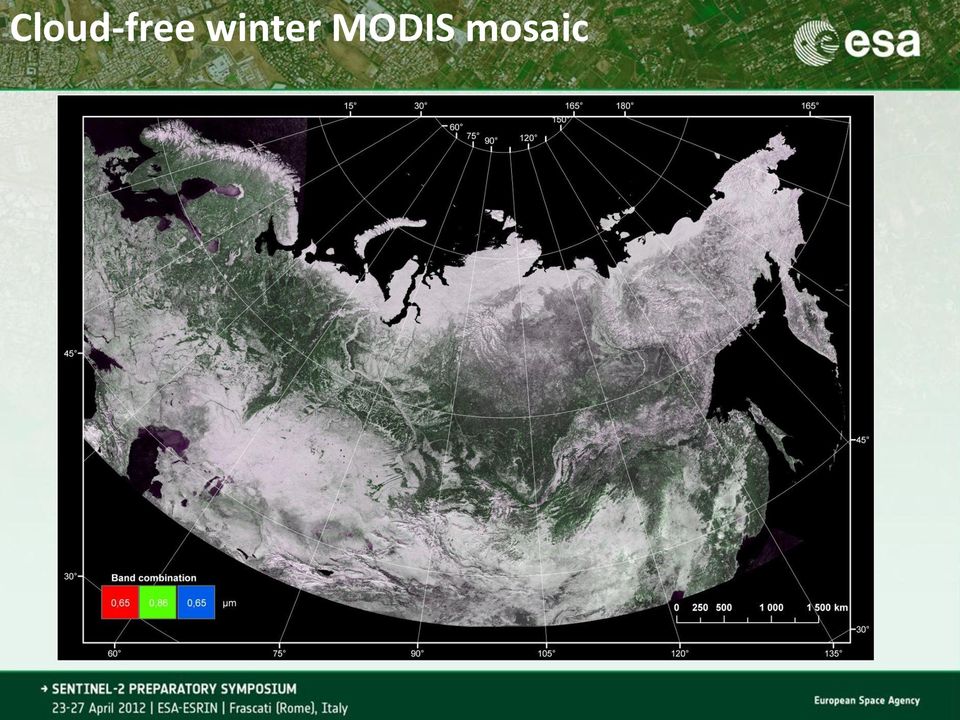
7 Cloud-free winter MODIS mosaic
8 Landsat-TM clouds and shadow masking Landsat-TM Clouds detection (in red) Geometric shadow belt (in black) 1. Clouds detection 2. Geometric modelling of shadows belts 3. Filtering of the geometric shadows 4. Spatial filtering of clouds and shadows Detected clouds (red) and shadows (green)

9 Main principals for land cover products generation chains Geographical focus on national level (entire Russia) with potential expansion Primary use of open sources of EO data, such as moderate res. (MODIS, SPOT-VGT, VIIRS and future Proba-V, Sentinel-3) and high-res. (Landsat-TM/ETM+ and future LCM and Sentinel-2) instruments Long-term time-series data analysis for land cover mapping and monitoring Spatially and temporally adaptive algorithms to ensure globally consistent land cover mapping and monitoring Technological focus on fully automated EO data processing chains to perform land monitoring in routine and repeatable manner

10 Main thematic focuses Generic land cover mapping Near-real time wildfire monitoring and assessment of fire consequences Forest cover mapping, characterisation and change monitoring Agricultural monitoring, including arable land dynamic, crop types mapping and status assessment

11 EO data based land cover products Generic land cover SPOT-Vegetation (1,15 km) MODIS (250 m) Landsat-TM/ETM+ (in development) Burnt area SPOT-Vegetation (1,15 km) MODIS (250 m) Landsat-TM/ETM+ Burnt severity / Trees mortality MODIS, 250 m Landsat-TM/ETM+ Arable lands (MODIS, 250 m) Crop types (MODIS, 250 m)
")
12 TerraNorte RLC Map The land cover map for Russia based on MODIS 250 m

13 Tree species mapping with MODIS reflectance in NIR ( nm) band oak birch 0,35 maple aspen linden 0,3 0,25 0,019 0,024 0,029 0,034 0,039 0,044 0,049 reflectance in RED ( nm) band MODIS winter composite oak birch aspen lime maple dark coniferous pine Forest Map of USSR (1990, 1:2,5 mln) Forest species mapping using MODIS
 Forest species mapping using")
14 Forest Stock Volume data Forest Stock Volume, m3/ha The forest stock volume is estimated based o combined use of MODIS (250 m) derived land cover map and national forest statistics for regions Dmitry Ershov et al., 2011

15 Burnt area mapping with MODIS

16 Burnt area mapping using MODIS and Landsat-TM/ETM Forest burnt area of fire season 2011 detected with MODIS

17 Burnt area map for year 2011 based on Landsat-TM/ETM Burnt area mapping technology using Landsat-TM data is in operation (> 3500 burs were mapped in Russia for 2011 fire season)

18 Annual mapping of arable lands using MODIS data time-series

 1 58 0 0 0 0 11 0 0 0 0 5,9 2 0 127 0 0 3 34 0 0 3 1 24,4 3 0 0 101 0 0 10 7 1 0 0 15,1 Classification 4 0 0 0 26 0 0 0")
19 Crop types classification using MODIS PVI 0,35 0,3 0,25 0,2 Peas Melilot Potato Alfalfa Perennials Spring crops Fallow Rape Winter rye Barley+Peas mixture 0,15 0,1 0, Apr 7-May 27-May 16-Jun 6-Jul 26-Jul 15-Aug 4-Sep 24-Sep Ground-truth Omission (%) , , ,1 Classification , , , , , , ,7 Commission (%) 3,3 3,1 9,8 3,7 0,9 6,5 4,5 9,8 11,1 9,8 93
 3,3 3,1 9,8 3,7 0,9 6,5 4,5 9,8 11,1")
20 VEGA Map Interface: Main Sections High-resolution satellite images Agriculture Forest Wild Fires Meteorology Generic map layers Basket for HR Images Map navigation tools

21 VEGA Map Interface The VEGA map interface provides easy access to Landsat-TM/ETM (and potentially other HR satellite data, including Sentinel-2) archive Operationally updating archive of Landsat-TM/ETM data; About 140,000 scenes are collected for the period ; Automated clouds/shadow detection and cloud-free compositing chains
22 MODIS and Landsat-TM/ETM+ data synergy in the VEGA Map Interface Multi-annual weekly update MODIS based NDVI profiles can be onthe-fly derived for any area of interest selected with Landsat-TM/ETM
23 Analysis of Forest Disturbances using VEGA Service web-tools August 7, 2009 June 10, 2011 Analysis of forest disturbances caused by hurricane wind in July 2010 with combine use of MODIS and Landsat-TM data
24 Analysis of logging activity using VEGA Service web-tools July 18, 2010 June 12, 2011
25 Crop status assessment at field level Assessment of winter crop status in spring Assessment of impact of drought on crop status Crop status assessment based on deviation of Vegetation Index seasonal development from multiannual average for same crop type

26 Crop status assessment at regional level
27 VEGA Service Users (I) Insurance Companies (II) Forest Industry (logging and paper companies) (III) Regional Administrations (IV) Public and Research Organisations
28 VEGA Service Perspectives (I) Integration of new EO data: a. Moderate resolution data (Sentinel-3, Proba-V, NPP) b. High resolution data (LDCM, Sentinel-2) (II) Integration of new thematic products: a. SAR data derived biomass b. Crop yield c. Crop-types and tree-species d. Biophysiscal characteristics (e.g. green vegetation area fraction) (III) Modelling component assimilated with RS products: a. Fire propagation b. Crop grow
Monitoring Overview with a Focus on Land Use Sustainability Metrics
 Monitoring Overview with a Focus on Land Use Sustainability Metrics Canadian Roundtable for Sustainable Crops. Nov 26, 2014 Agriclimate, Geomatics, and Earth Observation Division (ACGEO). Presentation
Land Use/ Land Cover Mapping Initiative for Kansas and the Kansas River Watershed
 Land Use/ Land Cover Mapping Initiative for Kansas and the Kansas River Watershed Kansas Biological Survey Kansas Applied Remote Sensing Program April 2008 Previous Kansas LULC Projects Kansas LULC Map
Aneeqa Syed [Hatfield Consultants] Vancouver GIS Users Group Meeting December 8, 2010
![Aneeqa Syed [Hatfield Consultants] Vancouver GIS Users Group Meeting December 8, 2010](/thumbs/27/11179985.jpg "Aneeqa Syed [Hatfield Consultants] Vancouver GIS Users Group Meeting December 8, 2010") NEAR-REAL-TIME FLOOD MAPPING AND MONITORING SERVICE Aneeqa Syed [Hatfield Consultants] Vancouver GIS Users Group Meeting December 8, 2010 SLIDE 1 MRC Flood Service Project Partners and Client Hatfield
NEAR-REAL-TIME FLOOD MAPPING AND MONITORING SERVICE Aneeqa Syed [Hatfield Consultants] Vancouver GIS Users Group Meeting December 8, 2010 SLIDE 1 MRC Flood Service Project Partners and Client Hatfield
Forest Fire Information System (EFFIS): Rapid Damage Assessment
: Rapid Damage Assessment") Forest Fire Information System (EFFIS): Fire Danger D Rating Rapid Damage Assessment G. Amatulli, A. Camia, P. Barbosa, J. San-Miguel-Ayanz OUTLINE 1. Introduction: what is the JRC 2. What is EFFIS 3.
Forest Fire Information System (EFFIS): Fire Danger D Rating Rapid Damage Assessment G. Amatulli, A. Camia, P. Barbosa, J. San-Miguel-Ayanz OUTLINE 1. Introduction: what is the JRC 2. What is EFFIS 3.
Data Processing Flow Chart
 Legend Start V1 V2 V3 Completed Version 2 Completion date Data Processing Flow Chart Data: Download a) AVHRR: 1981-1999 b) MODIS:2000-2010 c) SPOT : 1998-2002 No Progressing Started Did not start 03/12/12
Methods for Monitoring Forest and Land Cover Changes and Unchanged Areas from Long Time Series
 Methods for Monitoring Forest and Land Cover Changes and Unchanged Areas from Long Time Series Project using historical satellite data from SACCESS (Swedish National Satellite Data Archive) for developing
Satellite Snow Monitoring Activities Project CRYOLAND
 Satellite Snow Monitoring Activities Project CRYOLAND Background material for participants to the Workshop on European Snow Monitoring Perspectives, Darmstadt, 4-5 December 2012. CryoLand provides Snow,
Global environmental information Examples of EIS Data sets and applications
 METIER Graduate Training Course n 2 Montpellier - february 2007 Information Management in Environmental Sciences Global environmental information Examples of EIS Data sets and applications Global datasets
VCS REDD Methodology Module. Methods for monitoring forest cover changes in REDD project activities
 1 VCS REDD Methodology Module Methods for monitoring forest cover changes in REDD project activities Version 1.0 May 2009 I. SCOPE, APPLICABILITY, DATA REQUIREMENT AND OUTPUT PARAMETERS Scope This module
Review for Introduction to Remote Sensing: Science Concepts and Technology
 Review for Introduction to Remote Sensing: Science Concepts and Technology Ann Johnson Associate Director [email protected] Funded by National Science Foundation Advanced Technological Education program [DUE
Cloud Masking and Cloud Products
 Cloud Masking and Cloud Products MODIS Operational Algorithm MOD35 Paul Menzel, Steve Ackerman, Richard Frey, Kathy Strabala, Chris Moeller, Liam Gumley, Bryan Baum MODIS Cloud Masking Often done with
Using Remote Sensing to Monitor Soil Carbon Sequestration
 Using Remote Sensing to Monitor Soil Carbon Sequestration E. Raymond Hunt, Jr. USDA-ARS Hydrology and Remote Sensing Beltsville Agricultural Research Center Beltsville, Maryland Introduction and Overview
Geospatial intelligence and data fusion techniques for sustainable development problems
 Geospatial intelligence and data fusion techniques for sustainable development problems Nataliia Kussul 1,2, Andrii Shelestov 1,2,4, Ruslan Basarab 1,4, Sergii Skakun 1, Olga Kussul 2 and Mykola Lavreniuk
Obtaining and Processing MODIS Data
 Obtaining and Processing MODIS Data MODIS is an extensive program using sensors on two satellites that each provide complete daily coverage of the earth. The data have a variety of resolutions; spectral,
A new SPOT4-VEGETATION derived land cover map of Northern Eurasia
 INT. J. REMOTE SENSING, 2003, VOL. 24, NO. 9, 1977 1982 A new SPOT4-VEGETATION derived land cover map of Northern Eurasia S. A. BARTALEV, A. S. BELWARD Institute for Environment and Sustainability, EC
Evaluation of Wildfire Duration Time Over Asia using MTSAT and MODIS
 Evaluation of Wildfire Duration Time Over Asia using MTSAT and MODIS Wataru Takeuchi * and Yusuke Matsumura Institute of Industrial Science, University of Tokyo, Japan Ce-504, 6-1, Komaba 4-chome, Meguro,
APPLICATION OF MULTITEMPORAL LANDSAT DATA TO MAP AND MONITOR LAND COVER AND LAND USE CHANGE IN THE CHESAPEAKE BAY WATERSHED
 APPLICATION OF MULTITEMPORAL LANDSAT DATA TO MAP AND MONITOR LAND COVER AND LAND USE CHANGE IN THE CHESAPEAKE BAY WATERSHED S. J. GOETZ Woods Hole Research Center Woods Hole, Massachusetts 054-096 USA
Automatic land-cover map production of agricultural areas using supervised classification of SPOT4(Take5) and Landsat-8 image time series.
 and Landsat-8 image time series.") Automatic land-cover map production of agricultural areas using supervised classification of SPOT4(Take5) and Landsat-8 image time series. Jordi Inglada 2014/11/18 SPOT4/Take5 User Workshop 2014/11/18
Automatic land-cover map production of agricultural areas using supervised classification of SPOT4(Take5) and Landsat-8 image time series. Jordi Inglada 2014/11/18 SPOT4/Take5 User Workshop 2014/11/18
Welcome to NASA Applied Remote Sensing Training (ARSET) Webinar Series
 Webinar Series") Welcome to NASA Applied Remote Sensing Training (ARSET) Webinar Series Introduction to Remote Sensing Data for Water Resources Management Course Dates: October 17, 24, 31 November 7, 14 Time: 8-9 a.m.
Welcome to NASA Applied Remote Sensing Training (ARSET) Webinar Series Introduction to Remote Sensing Data for Water Resources Management Course Dates: October 17, 24, 31 November 7, 14 Time: 8-9 a.m.
A remote sensing instrument collects information about an object or phenomenon within the
 Satellite Remote Sensing GE 4150- Natural Hazards Some slides taken from Ann Maclean: Introduction to Digital Image Processing Remote Sensing the art, science, and technology of obtaining reliable information
ANALYSIS OF FOREST CHANGE IN FIRE DAMAGE AREA USING SATELLITE IMAGES
 ANALYSIS OF FOREST CHANGE IN FIRE DAMAGE AREA USING SATELLITE IMAGES Joon Mook Kang, Professor Joon Kyu Park, Ph.D Min Gyu Kim, Ph.D._Candidate Dept of Civil Engineering, Chungnam National University 220
dynamic vegetation model to a semi-arid
 Application of a conceptual distributed dynamic vegetation model to a semi-arid basin, SE of Spain By: M. Pasquato, C. Medici and F. Francés Universidad Politécnica de Valencia - Spain Research Institute
Monitoring Global Crop Condition Indicators Using a Web-Based Visualization Tool
 Monitoring Global Crop Condition Indicators Using a Web-Based Visualization Tool Bob Tetrault, Regional Commodity Analyst, and Bob Baldwin, GIS Specialist, USDA, Foreign Agricultural Service, Washington,
Using Remote Sensing Imagery to Evaluate Post-Wildfire Damage in Southern California
 Graham Emde GEOG 3230 Advanced Remote Sensing February 22, 2013 Lab #1 Using Remote Sensing Imagery to Evaluate Post-Wildfire Damage in Southern California Introduction Wildfires are a common disturbance
Vulnerability assessment of ecosystem services for climate change impacts and adaptation (VACCIA)
") Vulnerability assessment of ecosystem services for climate change impacts and adaptation (VACCIA) Action 2: Derivation of GMES-related remote sensing data Deliverable 1: Time-series of Earth Observation
Vulnerability assessment of ecosystem services for climate change impacts and adaptation (VACCIA) Action 2: Derivation of GMES-related remote sensing data Deliverable 1: Time-series of Earth Observation
Land Use/Land Cover Map of the Central Facility of ARM in the Southern Great Plains Site Using DOE s Multi-Spectral Thermal Imager Satellite Images
 Land Use/Land Cover Map of the Central Facility of ARM in the Southern Great Plains Site Using DOE s Multi-Spectral Thermal Imager Satellite Images S. E. Báez Cazull Pre-Service Teacher Program University
JECAM Site Ukraine. 21 23 July 2014. Team Leader: Kussul Nataliia. JECAM/GEOGLAM Science Meeting Ottawa, Canada
 Site Ukraine /GEOGLAM Science, Canada 21 23 July Team Leader: Kussul Nataliia Members: Shelestov Andrii, Skakun Sergii Site Description Kyiv oblast (SRI, area 28,000 km 2 ) & intensive observation sub-site
Digital image processing
 746A27 Remote Sensing and GIS Lecture 4 Digital image processing Chandan Roy Guest Lecturer Department of Computer and Information Science Linköping University Digital Image Processing Most of the common
Landsat Monitoring our Earth s Condition for over 40 years
 Landsat Monitoring our Earth s Condition for over 40 years Thomas Cecere Land Remote Sensing Program USGS ISPRS:Earth Observing Data and Tools for Health Studies Arlington, VA August 28, 2013 U.S. Department
Outline - needs of land cover - global land cover projects - GLI land cover product. legend. Cooperation with Global Mapping project
 Land Cover Mapping by GLI data Ryutaro Tateishi Center for Environmental Remote Sensing (CEReS) Chiba University E-mail: [email protected] Outline - needs of land cover - global land cover
Monitoring of Arctic Conditions from a Virtual Constellation of Synthetic Aperture Radar Satellites
 DISTRIBUTION STATEMENT A. Approved for public release; distribution is unlimited. Monitoring of Arctic Conditions from a Virtual Constellation of Synthetic Aperture Radar Satellites Hans C. Graber RSMAS
Proba-V: Earthwatch Mission as part of ESA s Earth Observation Programmes
 Proba-V: Earthwatch Mission as part of ESA s Earth Observation Programmes Antwerp 05.07.2013 Bianca Hoersch Proba-V Mission Manager Third Party Mission & Sentinel-2 Mission Manager Earth Observation Directorate,
Development of an Integrated Data Product for Hawaii Climate
 Development of an Integrated Data Product for Hawaii Climate Jan Hafner, Shang-Ping Xie (PI)(IPRC/SOEST U. of Hawaii) Yi-Leng Chen (Co-I) (Meteorology Dept. Univ. of Hawaii) contribution Georgette Holmes
Data processing (3) Cloud and Aerosol Imager (CAI)
 Cloud and Aerosol Imager (CAI)") Data processing (3) Cloud and Aerosol Imager (CAI) 1) Nobuyuki Kikuchi, 2) Haruma Ishida, 2) Takashi Nakajima, 3) Satoru Fukuda, 3) Nick Schutgens, 3) Teruyuki Nakajima 1) National Institute for Environmental
Data processing (3) Cloud and Aerosol Imager (CAI) 1) Nobuyuki Kikuchi, 2) Haruma Ishida, 2) Takashi Nakajima, 3) Satoru Fukuda, 3) Nick Schutgens, 3) Teruyuki Nakajima 1) National Institute for Environmental
Generation of Cloud-free Imagery Using Landsat-8
 Generation of Cloud-free Imagery Using Landsat-8 Byeonghee Kim 1, Youkyung Han 2, Yonghyun Kim 3, Yongil Kim 4 Department of Civil and Environmental Engineering, Seoul National University (SNU), Seoul,
Resolutions of Remote Sensing
 Resolutions of Remote Sensing 1. Spatial (what area and how detailed) 2. Spectral (what colors bands) 3. Temporal (time of day/season/year) 4. Radiometric (color depth) Spatial Resolution describes how
The Future of Geospatial Big Data Giovanni Marchisio, Ph.D., Director Product Development
 The Future of Geospatial Big Data Giovanni Marchisio, Ph.D., Director Product Development Nuclear Power Plant, Doel, Belgium December 10, 2011 WorldView-2 Why Geospatial Big Data? We Are the Innovators
Overview of NASA Applied Remote Sensing Training Program on Water Resources and Disaster Management
 Overview of NASA Applied Remote Sensing Training Program on Water Resources and Disaster Management ARSET Applied Remote SEnsing Training A project of NASA Applied Sciences Outline About ARSET ARSET Trainings
ASSESSMENT OF FOREST RECOVERY AFTER FIRE USING LANDSAT TM IMAGES AND GIS TECHNIQUES: A CASE STUDY OF MAE WONG NATIONAL PARK, THAILAND
 ASSESSMENT OF FOREST RECOVERY AFTER FIRE USING LANDSAT TM IMAGES AND GIS TECHNIQUES: A CASE STUDY OF MAE WONG NATIONAL PARK, THAILAND Sunee Sriboonpong 1 Yousif Ali Hussin 2 Alfred de Gier 2 1 Forest Resource
MODIS IMAGES RESTORATION FOR VNIR BANDS ON FIRE SMOKE AFFECTED AREA
 MODIS IMAGES RESTORATION FOR VNIR BANDS ON FIRE SMOKE AFFECTED AREA Li-Yu Chang and Chi-Farn Chen Center for Space and Remote Sensing Research, National Central University, No. 300, Zhongda Rd., Zhongli
SPOT 4 TAKE 5 Program
 SPOT 4 TAKE 5 Program Snow cover monitoring in the French Alps physical properties of surface snow, snow cover dynamics impact on vegetation Jean-Pierre DEDIEU, LTHE- CNRS, Grenoble [email protected]
AMESD/MESA & GMES and Africa
 AMESD/MESA & GMES and Africa Jolly Wasambo AUC-REA Outline Background MESA: objective and expected results Thematic actions & services Some concerns about natural resources Land degradation Loss of soil
Analysis of MODIS leaf area index product over soybean areas in Rio Grande do Sul State, Brazil
 Analysis of MODIS leaf area index product over soybean areas in Rio Grande do Sul State, Brazil Rodrigo Rizzi 1 Bernardo Friedrich Theodor Rudorff 1 Yosio Edemir Shimabukuro 1 1 Instituto Nacional de Pesquisas
GLOBAL FORUM London, October 24 & 25, 2012
 GLOBAL FORUM London, October 24 & 25, 2012-1 - Global Observations of Gas Flares Improving Global Observations of Gas Flares With Data From the Suomi NPP Visible Infrared Imaging Radiometer Suite (VIIRS)
From Whitehall to orbit and back again: using space in government
 From Whitehall to orbit and back again: using space in government 18 th June 2014 Bristol 25 th June 2014 Liverpool 3 rd July 2014 -Newcastle Space for Smarter Government Programme ([email protected])
A KNOWLEDGE-BASED APPROACH FOR REDUCING CLOUD AND SHADOW ABSTRACT
 A KNOWLEDGE-BASED APPROACH FOR REDUCING CLOUD AND SHADOW Mingjun Song, Graduate Research Assistant Daniel L. Civco, Director Laboratory for Earth Resources Information Systems Department of Natural Resources
Environmental Remote Sensing GEOG 2021
 Environmental Remote Sensing GEOG 2021 Lecture 4 Image classification 2 Purpose categorising data data abstraction / simplification data interpretation mapping for land cover mapping use land cover class
 European Forest Data Centre Biosoil/Biodiversity Forest Type Map 2006 P. Kempeneers, JRC T. Durant F. Sedano, JRC L. Seebach, JRC J. San-Miguel-Ayanz, JRC EC -, IES Land Management and Natural Hazard Unit
MOD09 (Surface Reflectance) User s Guide
 User s Guide") MOD09 (Surface ) User s Guide MODIS Land Surface Science Computing Facility Principal Investigator: Dr. Eric F. Vermote Web site: http://modis-sr.ltdri.org Correspondence e-mail address: [email protected]
MOD09 (Surface ) User s Guide MODIS Land Surface Science Computing Facility Principal Investigator: Dr. Eric F. Vermote Web site: http://modis-sr.ltdri.org Correspondence e-mail address: [email protected]
MASS PROCESSING OF REMOTE SENSING DATA FOR ENVIRONMENTAL EVALUATION IN EUROPE
 MASS PROCESSING OF REMOTE SENSING DATA FOR ENVIRONMENTAL EVALUATION IN EUROPE Lic. Adrián González Applications Research Earth Science Conference 2014 29.07.2014 Earth Science San Conference Francisco
A comparison of NOAA/AVHRR derived cloud amount with MODIS and surface observation
 A comparison of NOAA/AVHRR derived cloud amount with MODIS and surface observation LIU Jian YANG Xiaofeng and CUI Peng National Satellite Meteorological Center, CMA, CHINA outline 1. Introduction 2. Data
The USGS Landsat Big Data Challenge
 The USGS Landsat Big Data Challenge Brian Sauer Engineering and Development USGS EROS [email protected] U.S. Department of the Interior U.S. Geological Survey USGS EROS and Landsat 2 Data Utility and Exploitation
AATSR Technical Note. Improvements to the AATSR IPF relating to Land Surface Temperature Retrieval and Cloud Clearing over Land
 AATSR Technical Note Improvements to the AATSR IPF relating to Land Surface Temperature Retrieval and Cloud Clearing over Land Author: Andrew R. Birks RUTHERFORD APPLETON LABORATORY Chilton, Didcot, Oxfordshire
Crop Drought Stress Monitoring by Remote Sensing (DROSMON) Overview. Werner Schneider
 Overview. Werner Schneider") Crop Drought Stress Monitoring by Remote Sensing (DROSMON) Overview Werner Schneider Institut of Surveying, Remote Sensing and Land Information Department of Landscape, Spatial and Infrastructure Sciences
Crop Drought Stress Monitoring by Remote Sensing (DROSMON) Overview Werner Schneider Institut of Surveying, Remote Sensing and Land Information Department of Landscape, Spatial and Infrastructure Sciences
STAR Algorithm and Data Products (ADP) Beta Review. Suomi NPP Surface Reflectance IP ARP Product
 Beta Review. Suomi NPP Surface Reflectance IP ARP Product") STAR Algorithm and Data Products (ADP) Beta Review Suomi NPP Surface Reflectance IP ARP Product Alexei Lyapustin Surface Reflectance Cal Val Team 11/26/2012 STAR ADP Surface Reflectance ARP Team Member
STAR Algorithm and Data Products (ADP) Beta Review Suomi NPP Surface Reflectance IP ARP Product Alexei Lyapustin Surface Reflectance Cal Val Team 11/26/2012 STAR ADP Surface Reflectance ARP Team Member
Calculation of Minimum Distances. Minimum Distance to Means. Σi i = 1
 Minimum Distance to Means Similar to Parallelepiped classifier, but instead of bounding areas, the user supplies spectral class means in n-dimensional space and the algorithm calculates the distance between
SEMI-AUTOMATED CLOUD/SHADOW REMOVAL AND LAND COVER CHANGE DETECTION USING SATELLITE IMAGERY
 SEMI-AUTOMATED CLOUD/SHADOW REMOVAL AND LAND COVER CHANGE DETECTION USING SATELLITE IMAGERY A. K. Sah a, *, B. P. Sah a, K. Honji a, N. Kubo a, S. Senthil a a PASCO Corporation, 1-1-2 Higashiyama, Meguro-ku,
How Landsat Images are Made
 How Landsat Images are Made Presentation by: NASA s Landsat Education and Public Outreach team June 2006 1 More than just a pretty picture Landsat makes pretty weird looking maps, and it isn t always easy
Multi-Temporal Wild Fire Monitoring in Lao PDR using MODIS Data
 Multi-Temporal Wild Fire Monitoring in Lao PDR using MODIS Data Vivarad Phonekeo Ph. D. Geoinformatics Center (GIC) Asian Institute of Technology [email protected], [email protected] www.vivarad.info Thatheva
The NASA NEESPI Data Portal to Support Studies of Climate and Environmental Changes in Non-boreal Europe
 The NASA NEESPI Data Portal to Support Studies of Climate and Environmental Changes in Non-boreal Europe Suhung Shen NASA Goddard Space Flight Center/George Mason University Gregory Leptoukh, Tatiana Loboda,
MODIS direct broadcast data for enhanced forecasting and real-time environmental decision making. The role of Remote Sensing in Wildfire Management
 MODIS direct broadcast data for enhanced forecasting and real-time environmental decision making The role of Remote Sensing in Wildfire Management Natural Disasters Natural disasters are continuously increasing
SatelliteRemoteSensing for Precision Agriculture
 SatelliteRemoteSensing for Precision Agriculture Managing Director WasatSp. z o.o. Copernicus the road to economic development Warsaw, 26-27 February 2015 Activitiesof WasatSp. z o.o. The company provides
Forestry Thematic Exploitation Platform Earth Observation Open Science 2.0
 Forestry Thematic Exploitation Platform Earth Observation Open Science 2.0 Tuomas Häme VTT Technical Research of Finland Ltd and the Forestry TEP Team Objective One-stop shop for forestry remote sensing
Tropical Horticulture: Lecture 2
 Lecture 2 Theory of the Tropics Earth & Solar Geometry, Celestial Mechanics The geometrical relationship between the earth and sun is responsible for the earth s climates. The two principal movements of
Measurement of the effect of biomass burning aerosol on inhibition of cloud formation over the Amazon
 Supporting Online Material for Koren et al. Measurement of the effect of biomass burning aerosol on inhibition of cloud formation over the Amazon 1. MODIS new cloud detection algorithm The operational
Land Cover Mapping of the Comoros Islands: Methods and Results. February 2014. ECDD, BCSF & Durrell Lead author: Katie Green
 Land Cover Mapping of the Comoros Islands: Methods and Results February 2014 ECDD, BCSF & Durrell Lead author: Katie Green About the ECDD project The ECDD project was run by Bristol Conservation & Science
Remote Sensing Method in Implementing REDD+
 Remote Sensing Method in Implementing REDD+ FRIM-FFPRI Research on Development of Carbon Monitoring Methodology for REDD+ in Malaysia Remote Sensing Component Mohd Azahari Faidi, Hamdan Omar, Khali Aziz
Emergency Management Service. early warning FLOOD AND FIRE ALERTS. Space
 Emergency Management Service early warning FLOOD AND FIRE ALERTS Space 1 Copernicus at a Glance Copernicus is the European Union s Earth Observation programme: a user-driven space programme under civil
Introduction to Imagery and Raster Data in ArcGIS
 Esri International User Conference San Diego, California Technical Workshops July 25, 2012 Introduction to Imagery and Raster Data in ArcGIS Simon Woo slides Cody Benkelman - demos Overview of Presentation
2.3 Spatial Resolution, Pixel Size, and Scale
 Section 2.3 Spatial Resolution, Pixel Size, and Scale Page 39 2.3 Spatial Resolution, Pixel Size, and Scale For some remote sensing instruments, the distance between the target being imaged and the platform,
Advanced Image Management using the Mosaic Dataset
 Esri International User Conference San Diego, California Technical Workshops July 25, 2012 Advanced Image Management using the Mosaic Dataset Vinay Viswambharan, Mike Muller Agenda ArcGIS Image Management
Virtual constellations, time series, and cloud screening opportunities for Sentinel 2 and Landsat
 Virtual constellations, time series, and cloud screening opportunities for Sentinel 2 and Landsat Sentinel 2 for Science Workshop 20 22 May 2014 ESA ESRIN, Frascati (Rome), Italy 1 Part 1: Title: Towards
GEOGG142 GMES Calibration & validation of EO products
 GEOGG142 GMES Calibration & validation of EO products Dr. Mat Disney [email protected] Pearson Building room 113 020 7679 0592 www.geog.ucl.ac.uk/~mdisney Outline Calibration & validation Example:
Spectral Response for DigitalGlobe Earth Imaging Instruments
 Spectral Response for DigitalGlobe Earth Imaging Instruments IKONOS The IKONOS satellite carries a high resolution panchromatic band covering most of the silicon response and four lower resolution spectral
Received in revised form 24 March 2004; accepted 30 March 2004
 Remote Sensing of Environment 91 (2004) 237 242 www.elsevier.com/locate/rse Cloud detection in Landsat imagery of ice sheets using shadow matching technique and automatic normalized difference snow index
CE394K GIS IN WATER RESOURCES TERM PROJECT REPORT
 CE394K GIS IN WATER RESOURCES TERM PROJECT REPORT Soil Water Balance in Southern California Cheng-Wei Yu Environmental and Water Resources Engineering Program Introduction Historical Drought Condition
Integrated Global Carbon Observations. Beverly Law Prof. Global Change Forest Science Science Chair, AmeriFlux Network Oregon State University
 Integrated Global Carbon Observations Beverly Law Prof. Global Change Forest Science Science Chair, AmeriFlux Network Oregon State University Total Anthropogenic Emissions 2008 Total Anthropogenic CO 2
Global land cover mapping: conceptual and historical background
 Space Research Institute Russian Academy of Sciences Global land cover mapping: conceptual and historical background Sergey BARTALEV with acknowledged contribution from: Etienne Bartholomé and Philippe
Cloud Detection for Sentinel 2. Curtis Woodcock, Zhe Zhu, Shixiong Wang and Chris Holden
 Cloud Detection for Sentinel 2 Curtis Woodcock, Zhe Zhu, Shixiong Wang and Chris Holden Background 3 primary spectral regions useful for cloud detection Optical Thermal Cirrus bands Legacy Landsats have
Asia-Pacific Environmental Innovation Strategy (APEIS)
") Asia-Pacific Environmental Innovation Strategy (APEIS) Integrated Environmental Monitoring IEM) Dust Storm Over-cultivation Desertification Urbanization Floods Deforestation Masataka WATANABE, National
Asia-Pacific Environmental Innovation Strategy (APEIS) Integrated Environmental Monitoring IEM) Dust Storm Over-cultivation Desertification Urbanization Floods Deforestation Masataka WATANABE, National
Temporal variation in snow cover over sea ice in Antarctica using AMSR-E data product
 Temporal variation in snow cover over sea ice in Antarctica using AMSR-E data product Michael J. Lewis Ph.D. Student, Department of Earth and Environmental Science University of Texas at San Antonio ABSTRACT