SatelliteRemoteSensing for Precision Agriculture
|
|
|
- Lorena Lester
- 8 years ago
- Views:
Transcription
1 SatelliteRemoteSensing for Precision Agriculture Managing Director WasatSp. z o.o. Copernicus the road to economic development Warsaw, February 2015

2 Activitiesof WasatSp. z o.o. The company provides geo-information services based on the results of scientific research. The product portfolio is built on creative use of advanced technologies, mainly satellite remote sensing, navigation techniques and mobile applications. Remote sensing analyses for environmental protection, agriculture and archaeology; Navigation solutions for indoor environment and robotics; Mobile geo-services

3 Modern agriculture Agriculture is one of the most dynamic and technology-driven sectors of the European and global economy. It faces a critical challenge of feeding 7 B people today and 9 B people in Technological developments that facilitate farmers addressing the demand: bioengineering (incl. GMO) and biochemistry, robotics, autonomous machinery steering, computing and big data management, mobile technology, sensors (satellite, airborne, ground sensors), precision agriculture (R.Saik, The AgricultureManifesto) Warsaw, February 2015
 and biochemistry, robotics, autonomous machinery steering, computing and big data management, mobile technology, sensors (satellite,")
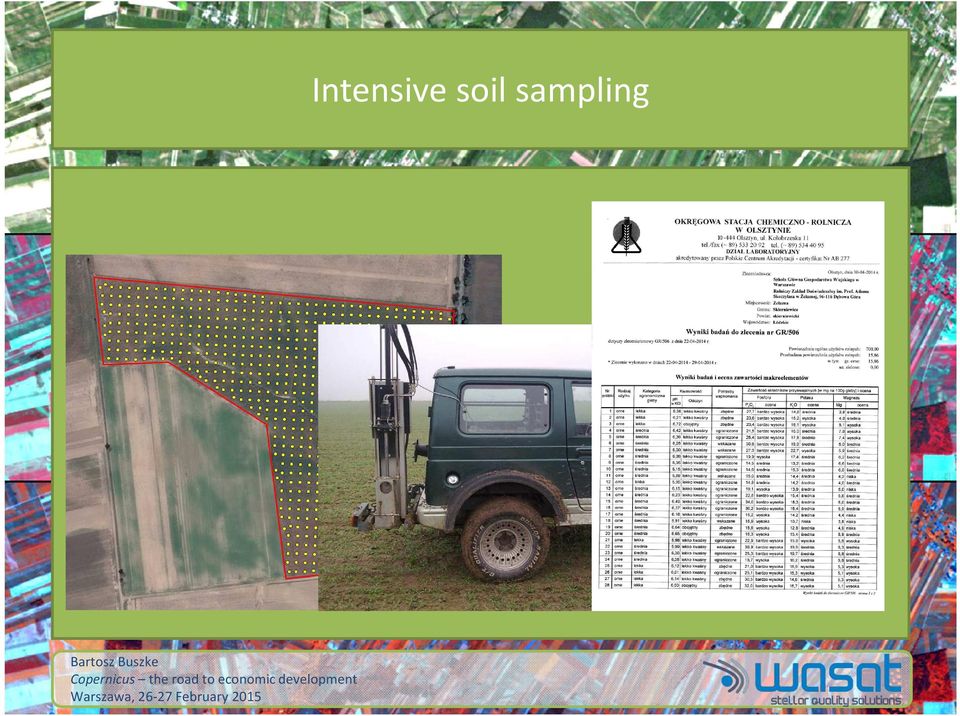
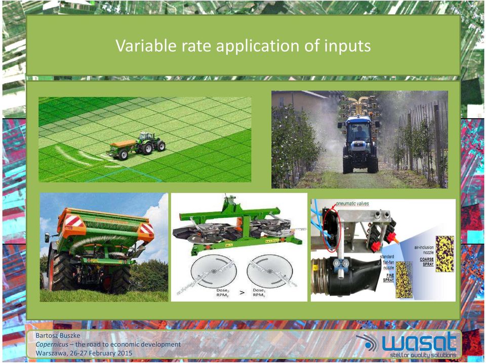
4 Precision agriculture Precision farming can be described as a comprehensive system designed to optimize agricultural production through the application of crop information, advanced technologies and management practices.(k.g. Cassman) In precision agriculture a field is considered as a spatially diverse structure, in contrast to awhole field approach in a traditional agriculture. This spatial variability needs to be addressed with a management strategy, supported by the technological solutions, that include: intensive soil sampling, remote sensing, geographic information systems (GIS), yield monitoring, positioning systems (GNSS, RTK), variable rate applicators of inputs (fertilizers, crop protection products, water) (T.A. Brase)
, yield monitoring, positioning systems (GNSS, RTK), variable rate applicators of inputs (fertilizers, crop protection products, water) (T.A. Brase)")
5 Intensive soil sampling

: Satellite")
6 3 layers of remote sensing Ground sensors: Airborne sensors (UAVs / drones): Satellite imagery:
: Satellite")
7 Use of satellite sensors in precision farming Land use / land cover Riparian and buffer zones Air Water Vapor Land Surface Temperature Precipitation Crop protection Disease Diagnosis Vegetation stress Wetness condition of vegetation Soil moisture Draught Hail protection Frost protection Yield estimation Weed control Sensor AVHRR Y - Y Y Y Y - Y Y - Y Y Y Y - MODIS Y - Y Y Y Y - Y Y - Y Y Y Y - Sentinel-1 Y Y Y Y Y - - Y - Landsat TM Y Y Y Y Y Y Y Y Y Y - SPOT Y Y Y Y Y Y Y VHR optical Y Y Y Y Y Y Y Y

8 Variable rate application of inputs
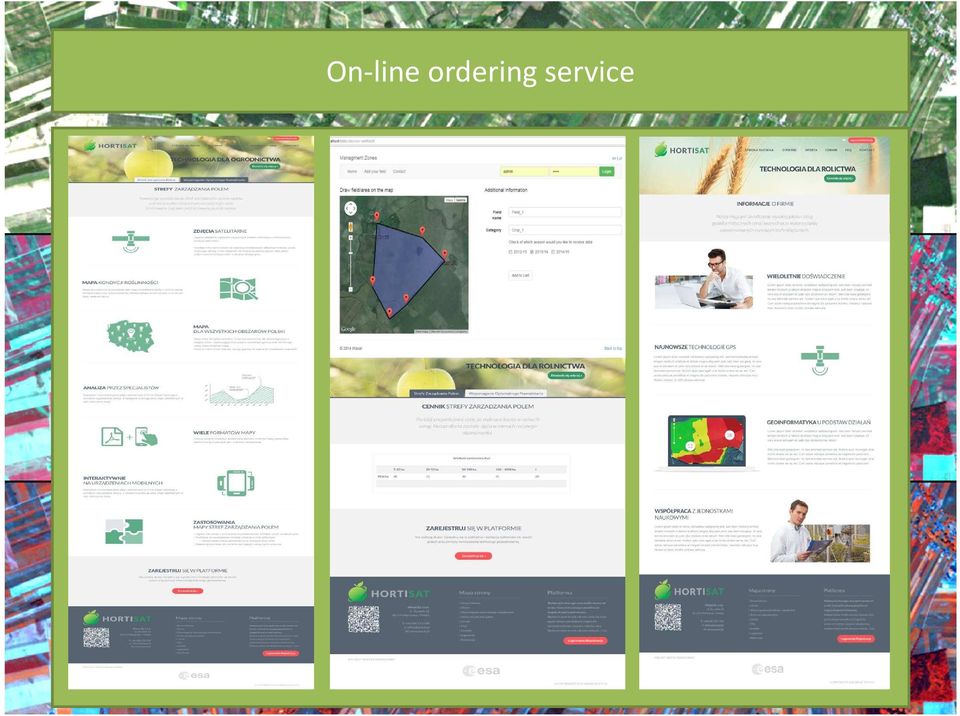
9 WASAT s product: management zones maps Precision agriculture relies on the concept that variability within the main factors responsible for crop yield can be identified, quantified, and spatially delineated. Polish farmers requirements: A tool/product that allows initiating precision agriculture practices Alternative for other, expensive solutions like tractor mounted sensors etc. A map thathelpstoimprovesoilsamplingstrategy The solution: Management Zonesmaps, thatfacilitate identifinglongterm productionzoneson the basis of historical assessment of crop productivity indices: archived satellite imagery as a data source on crop historical conditions algorithmof data fusionthatenablesthe useof varioussensorsand imagery of different resolution web-based and mobile tools for distribution of the product


10 Product development Example of datasets: Landsat 5 TM Terra ASTER Rapid Eye Landsat 8 OLI Vegetation Indices: NDVI OSAVI WDRVI ARVI EVI NDII MSI GNDVI mpsri TCARI ph Kruskal-Wallis chi-squared = , df = 3, p-value = Magnesium Kruskal-Wallis chi-squared = , df = 3, p-value = Potassium Kruskal-Wallis chi-squared = , df = 3, p-value < 2.2e-16 Phosphorus Kruskal-Wallis chi-squared = , df = 3, p-value < 2.2e-16

11 Product development Numerous approaches to the fusion of datasets and different orders of operations were tested: Indices calculation Image resampling Different sensor images multiplication, addition and averaging Different year images multiplication, addition and averaging Different index images multiplication, addition and averaging Median filtering Majority filtering Density slicing Unsupervised classification Image segmentation Management zones delineation methodology was developed in cooperation with the University of Warsaw and with Warsaw University of Life Sciences. The work was performed in the frame of HortiSat PECS project funded by ESA.

12 Product development Map algebra Maps of management zones are based on spatial distribution of vegetation conditions and their temporal stability. Map algebra Clipping & resampling Map algebra ISODATA clasification Density slice Density slice Vectorization Vectorization Additional products

13 On-line ordering service
14 Examples of MZ Maps delivered to farmers

15 Application of the maps Mapsofmanagementzonescanbeprovidedeitherintheformofapapermap,anelectronicfile and in the form of an interactive map. They can be displayed in a web browser or on a mobile device. By displaying a map on a smartphone or a tablet, a farmer can locate his position in the field and verify in which zone he currently operates. Use cases: Overview of the spatial variability of a field, especially for medium and large-scale farmers or those who plan to purchase new land parcels; Basis for preparing soil sampling strategy: more accurate map of soil conditions with smaller quantity of analysed samples; Guidelines for planning variable rate application of inputs (esp. nitrogen fertilizers).

16 Expectations regarding the Copernicus Programme WASAT develops advisory service based on satellite imagery for farmers who irrigate their crops (mostly horticultural growers): evapotranspiration measurements mainly rely on AVHRR data, but much more information on water/moisture conditions are necessary in order to effectively address users expectations: a soil moisture information based on Sentinel-1 imagery can be a partial solution. We look forward to deriving specific products from Sentinel-2 imagery that can be useful for crop monitoring, and, consequently, for variable rate application of inputs. Sentinel Collaborative Ground Segment site in Poland would certainly facilitate an access to Sentinel data.

17 Thank you for your attention. Tel:

Connected Farm Field Services. Dan Rooney InfoAg Conference, July 30, 2014
 Connected Farm Field Services Dan Rooney InfoAg Conference, July 30, 2014 What is Connected Farm? Connected Farm is an integrated operations management solution that combines industry-leading hardware,
Remote Sensing Applications for Precision Agriculture
 Remote Sensing Applications for Precision Agriculture Farm Progress Show Chris J. Johannsen, Paul G. Carter and Larry L. Biehl Department of Agronomy and Laboratory for Applications of Remote Sensing (LARS)
Research Roadmap for the Future. National Grape and Wine Initiative March 2013
 Research Roadmap for the Future National Grape and Wine Initiative March 2013 Objective of Today s Meeting Our mission drives the roadmap Our Mission Drive research to maximize productivity, sustainability
Using Remote Sensing to Monitor Soil Carbon Sequestration
 Using Remote Sensing to Monitor Soil Carbon Sequestration E. Raymond Hunt, Jr. USDA-ARS Hydrology and Remote Sensing Beltsville Agricultural Research Center Beltsville, Maryland Introduction and Overview
Site-specific management at Bowles Farming Company. UC Davis Precision Ag Workshop 7/14/2010 Cannon Michael Bowles Farming Company, Inc.
 Site-specific management at Bowles Farming Company UC Davis Precision Ag Workshop 7/14/2010 Cannon Michael Bowles Farming Company, Inc. Bowles Farming Company, Inc. Family owned and operated 150+ years
Land Use/Land Cover Map of the Central Facility of ARM in the Southern Great Plains Site Using DOE s Multi-Spectral Thermal Imager Satellite Images
 Land Use/Land Cover Map of the Central Facility of ARM in the Southern Great Plains Site Using DOE s Multi-Spectral Thermal Imager Satellite Images S. E. Báez Cazull Pre-Service Teacher Program University
From Whitehall to orbit and back again: using space in government
 From Whitehall to orbit and back again: using space in government 18 th June 2014 Bristol 25 th June 2014 Liverpool 3 rd July 2014 -Newcastle Space for Smarter Government Programme (ssgp@sa.catapult.org.uk)
Monitoring Global Crop Condition Indicators Using a Web-Based Visualization Tool
 Monitoring Global Crop Condition Indicators Using a Web-Based Visualization Tool Bob Tetrault, Regional Commodity Analyst, and Bob Baldwin, GIS Specialist, USDA, Foreign Agricultural Service, Washington,
How can information technology play a role in primary industries climate resilience?
 Manage Data. Harvest Information. How can information technology play a role in primary industries climate resilience? CHALLENGES FOR WORLD AGRICULTURE 9 Billion people on earth by 2040 Up to 40% of food
Welcome to NASA Applied Remote Sensing Training (ARSET) Webinar Series
 Webinar Series") Welcome to NASA Applied Remote Sensing Training (ARSET) Webinar Series Introduction to Remote Sensing Data for Water Resources Management Course Dates: October 17, 24, 31 November 7, 14 Time: 8-9 a.m.
Welcome to NASA Applied Remote Sensing Training (ARSET) Webinar Series Introduction to Remote Sensing Data for Water Resources Management Course Dates: October 17, 24, 31 November 7, 14 Time: 8-9 a.m.
IMPERVIOUS SURFACE MAPPING UTILIZING HIGH RESOLUTION IMAGERIES. Authors: B. Acharya, K. Pomper, B. Gyawali, K. Bhattarai, T.
 IMPERVIOUS SURFACE MAPPING UTILIZING HIGH RESOLUTION IMAGERIES Authors: B. Acharya, K. Pomper, B. Gyawali, K. Bhattarai, T. Tsegaye ABSTRACT Accurate mapping of artificial or natural impervious surfaces
VISUALIZATION OF A CROP SEASON THE INTEGRATION OF REMOTELY SENSED DATA AND SURVEY DATA
 VISUALIZATION OF A CROP SEASON THE INTEGRATION OF REMOTELY SENSED DATA AND SURVEY DATA Gail Wade GIS Analyst, Spatial Analysis Research Section George Hanuschak Chief, Geospatial Information Branch Research
Big Data & Big Opportunities
 Big Data & Big Opportunities Dr. Matt Darr, Iowa State University For a copy of this slide deck please send an email request to darr@iastate.edu Presentation Guiding Principles No intent to be critical
Monitoring Overview with a Focus on Land Use Sustainability Metrics
 Monitoring Overview with a Focus on Land Use Sustainability Metrics Canadian Roundtable for Sustainable Crops. Nov 26, 2014 Agriclimate, Geomatics, and Earth Observation Division (ACGEO). Presentation
Digital Agriculture: Leveraging Technology and Information into Profitable Decisions
 Digital Agriculture: Leveraging Technology and Information into Profitable Decisions Dr. Matt Darr, Ag & Biosystems Engineering Advancing Agricultural Performance and Environmental Stewardship Some material
Precision Agriculture. Lucas Rios do Amaral Professor FEAGRI/UNICAMP Agronomist, PhD.
 Precision Agriculture Lucas Rios do Amaral Professor FEAGRI/UNICAMP Agronomist, PhD. August 04 th 2015 Conventional agriculture Deal with the entire are as it is homogeneous.. ...but it never is. Corn
Automatic land-cover map production of agricultural areas using supervised classification of SPOT4(Take5) and Landsat-8 image time series.
 and Landsat-8 image time series.") Automatic land-cover map production of agricultural areas using supervised classification of SPOT4(Take5) and Landsat-8 image time series. Jordi Inglada 2014/11/18 SPOT4/Take5 User Workshop 2014/11/18
Automatic land-cover map production of agricultural areas using supervised classification of SPOT4(Take5) and Landsat-8 image time series. Jordi Inglada 2014/11/18 SPOT4/Take5 User Workshop 2014/11/18
GPS Applications in Agriculture. Gary T. Roberson Agricultural Machinery Systems
 GPS Applications in Agriculture Gary T. Roberson Agricultural Machinery Systems What is a Positioning System? A position information system enables the user to determine absolute or relative location of
U.S. Geological Survey Earth Resources Operation Systems (EROS) Data Center
 Data Center") U.S. Geological Survey Earth Resources Operation Systems (EROS) Data Center World Data Center for Remotely Sensed Land Data USGS EROS DATA CENTER Land Remote Sensing from Space: Acquisition to Applications
U.S. Geological Survey Earth Resources Operation Systems (EROS) Data Center World Data Center for Remotely Sensed Land Data USGS EROS DATA CENTER Land Remote Sensing from Space: Acquisition to Applications
Comprehensive Data Collection by Sensor Network and Optical Sensor for Agricultural Big Data
 Comprehensive Data Collection by Sensor Network and Optical Sensor for Agricultural Big Data Masayuki HIRAFUJI* ** * NARO National Agriculture and Food Research Organization ** University of Tsukuba Big
Cultivating Agricultural Information Management System Using GIS Technology
 Hitachi Review Vol. 58 (2009), No. 6 265 Cultivating Agricultural Information Management System Using GIS Technology Improving Agricultural Efficiency through Information Technology Osamu Nishiguchi Noriko
Land Use/ Land Cover Mapping Initiative for Kansas and the Kansas River Watershed
 Land Use/ Land Cover Mapping Initiative for Kansas and the Kansas River Watershed Kansas Biological Survey Kansas Applied Remote Sensing Program April 2008 Previous Kansas LULC Projects Kansas LULC Map
Small Steps Towards Big Data Ric Clarke, Australian Bureau of Statistics
 Small Steps Towards Big Data Ric Clarke, Australian Bureau of Statistics ECB Workshop on Using Big Data, 7-8 April 2014 1 Agenda Review some basic Big Data concepts Describe the Big Data opportunity for
AAFC Medium-Resolution EO Data Activities for Agricultural Risk Assessment
 AAFC Medium-Resolution EO Data Activities for Agricultural Risk Assessment North American Drought Monitor (NADM) Ottawa, Ontario, Canada. October 15-17 2008. A. Davidson 1, A. Howard 1,2, K. Sun 1, M.
Big Data: Challenges in Agriculture. Big Data Summit, November 2014 Moorea Brega: Agronomic Modeling Lead The Climate Corporation
 Big Data: Challenges in Agriculture Big Data Summit, November 2014 Moorea Brega: Agronomic Modeling Lead The Climate Corporation Outline THE AGRICULTURAL CHALLENGE DATA SCIENCE MEETS AGRICULTURE THE ROLE
ipot project Industrial Potato monitoring for the Belgian potato sector
 ipot project Industrial Potato monitoring for the Belgian potato sector Yannick Curnel, Jean-Pierre Goffart, Viviane Planchon (CRA-W) Version 25/04/2014 Financed by : BELSPO Project of 36 month 01/06/2014-31/05/2017
ENVIRONMENTAL MONITORING Vol. I - Remote Sensing (Satellite) System Technologies - Michael A. Okoye and Greg T. Koeln
 System Technologies - Michael A. Okoye and Greg T. Koeln") REMOTE SENSING (SATELLITE) SYSTEM TECHNOLOGIES Michael A. Okoye and Greg T. Earth Satellite Corporation, Rockville Maryland, USA Keywords: active microwave, advantages of satellite remote sensing, atmospheric
REMOTE SENSING (SATELLITE) SYSTEM TECHNOLOGIES Michael A. Okoye and Greg T. Earth Satellite Corporation, Rockville Maryland, USA Keywords: active microwave, advantages of satellite remote sensing, atmospheric
Remote Sensing and GIS Application In Change Detection Study In Urban Zone Using Multi Temporal Satellite
 Remote Sensing and GIS Application In Change Detection Study In Urban Zone Using Multi Temporal Satellite R.Manonmani, G.Mary Divya Suganya Institute of Remote Sensing, Anna University, Chennai 600 025
Modern Agricultural Digital Management Network Information System of Heilongjiang Reclamation Area Farm
 Modern Agricultural Digital Management Network Information System of Heilongjiang Reclamation Area Farm Xi Wang, Chun Wang, Wei Dong Zhuang, and Hui Yang Engineering Collage, Heilongjiang August the First
OPERATIONAL REMOTE SENSING PROGRAMS IN HUNGARY: FROM CROP MONITORING TO DISASTER MANAGEMENT
 OPERATIONAL REMOTE SENSING PROGRAMS IN HUNGARY: FROM CROP MONITORING TO DISASTER MANAGEMENT Gábor Csornai, Béla Pokoly*, István László, Zsuzsanna Suba, Erika Bognár, Csaba Wirnhardt, Gizella Nádor, Irén
Evaluation of Wildfire Duration Time Over Asia using MTSAT and MODIS
 Evaluation of Wildfire Duration Time Over Asia using MTSAT and MODIS Wataru Takeuchi * and Yusuke Matsumura Institute of Industrial Science, University of Tokyo, Japan Ce-504, 6-1, Komaba 4-chome, Meguro,
Using Technology and Big Data to Improve Profits. Matt Darr, Agricultural & Biosystems Engineering
 Using Technology and Big Data to Improve Profits Matt Darr, Agricultural & Biosystems Engineering 2015 THE YEAR OF BIG DATA Why the New Emphasis on Data Today? Autosteering and swath control technology
FARMING FOR THE FUTURE How mineral fertilizers can feed the world and maintain its resources in an Integrated Farming System
 How mineral fertilizers can feed the world and maintain its resources in an Integrated Farming System european fertilizer manufacturers association Global trends in population growth (Population 1000 million),
An overview of Precision Farming technologies: what they are, why they work and how they can be used to improve field management and water quality
 An overview of Precision Farming technologies: what they are, why they work and how they can be used to improve field management and water quality Peter Enright Farm Management & Technology Program Faculty
Background on Appropriate Precision Farming for Enhancing the Sustainability of Rice Production
 Background on Appropriate Precision Farming for Enhancing the Sustainability of Rice Production United Nations Centre for Sustainable Agricultural Mechanization (UNCSAM) & Malaysian Agricultural Research
gebruiken voor aardse toepassingen
 26/03/2014 Satellietgegevens gebruiken voor aardse toepassingen Dirk Van Speybroeck dirk.vanspeybroeck@vito.be VITO, VIsion on TechnOlogy» een op Europees vlak toonaangevend, onafhankelijk onderzoeks-
Review for Introduction to Remote Sensing: Science Concepts and Technology
 Review for Introduction to Remote Sensing: Science Concepts and Technology Ann Johnson Associate Director ann@baremt.com Funded by National Science Foundation Advanced Technological Education program [DUE
Environmental Data Services for Delaware:
 Environmental Data Services for Delaware: Serving Emergency Responders, Planners, and Researchers Network Delaware Day November 6, 2013 Overview Operational Data Services More than just research DEOS and
ENERGY IN FERTILIZER AND PESTICIDE PRODUCTION AND USE
 Farm Energy IQ Conserving Energy in Nutrient Use and Pest Control INTRODUCTION Fertilizers and pesticides are the most widely used sources of nutrients and pest control, respectively. Fertilizer and pesticides
Personal Computer Farming Strategies - Advantages of Icerop farmer Field yield
 icrop farmer field yield icrop digital harvest cropadvice efficiency communication croptimeline precisionfarming CRM crop protection Platform planning soil fertilizing COMPANY smartphone agronomist GEO
Objectives. Raster Data Discrete Classes. Spatial Information in Natural Resources FANR 3800. Review the raster data model
 Spatial Information in Natural Resources FANR 3800 Raster Analysis Objectives Review the raster data model Understand how raster analysis fundamentally differs from vector analysis Become familiar with
ForeCAST : Use of VHR satellite data for forest cartography
 ForeCAST : Use of VHR satellite data for forest cartography I-MAGE CONSULT UCL- Dpt Sciences du Milieu et de l Aménagement du Territoire Description of the partnership I-MAGE Consult Private partner Team
Overview of NASA Applied Remote Sensing Training Program on Water Resources and Disaster Management
 Overview of NASA Applied Remote Sensing Training Program on Water Resources and Disaster Management ARSET Applied Remote SEnsing Training A project of NASA Applied Sciences Outline About ARSET ARSET Trainings
World Water and Climate Atlas
 International Water Management Institute World Water and Climate Atlas Direct access to water and climate data improves agricultural planning The IWMI World Water and Climate Atlas provides rapid access
New development of automation for agricultural machinery
 New development of automation for agricultural machinery a versitale technology in automation of agriculture machinery VDI-Expertenforum 2011-04-06 1 Mechanisation & Automation Bigger and bigger Jaguar
Data Management Framework for the North American Carbon Program
 Data Management Framework for the North American Carbon Program Bob Cook, Peter Thornton, and the Steering Committee Image courtesy of NASA/GSFC NACP Data Management Planning Workshop New Orleans, LA January
The Challenges of Geospatial Analytics in the Era of Big Data
 The Challenges of Geospatial Analytics in the Era of Big Data Dr Noordin Ahmad National Space Agency of Malaysia (ANGKASA) CITA 2015: 4-5 August 2015 Kuching, Sarawak Big datais an all-encompassing term
Asia-Pacific Environmental Innovation Strategy (APEIS)
") Asia-Pacific Environmental Innovation Strategy (APEIS) Integrated Environmental Monitoring IEM) Dust Storm Over-cultivation Desertification Urbanization Floods Deforestation Masataka WATANABE, National
Asia-Pacific Environmental Innovation Strategy (APEIS) Integrated Environmental Monitoring IEM) Dust Storm Over-cultivation Desertification Urbanization Floods Deforestation Masataka WATANABE, National
Crop Drought Stress Monitoring by Remote Sensing (DROSMON) Overview. Werner Schneider
 Overview. Werner Schneider") Crop Drought Stress Monitoring by Remote Sensing (DROSMON) Overview Werner Schneider Institut of Surveying, Remote Sensing and Land Information Department of Landscape, Spatial and Infrastructure Sciences
Crop Drought Stress Monitoring by Remote Sensing (DROSMON) Overview Werner Schneider Institut of Surveying, Remote Sensing and Land Information Department of Landscape, Spatial and Infrastructure Sciences
Research on Soil Moisture and Evapotranspiration using Remote Sensing
 Research on Soil Moisture and Evapotranspiration using Remote Sensing Prof. dr. hab Katarzyna Dabrowska Zielinska Remote Sensing Center Institute of Geodesy and Cartography 00-950 Warszawa Jasna 2/4 Field
APPLICATION OF TERRA/ASTER DATA ON AGRICULTURE LAND MAPPING. Genya SAITO*, Naoki ISHITSUKA*, Yoneharu MATANO**, and Masatane KATO***
 APPLICATION OF TERRA/ASTER DATA ON AGRICULTURE LAND MAPPING Genya SAITO*, Naoki ISHITSUKA*, Yoneharu MATANO**, and Masatane KATO*** *National Institute for Agro-Environmental Sciences 3-1-3 Kannondai Tsukuba
Paperless Processes from Underwriting to Claims Management
 Paperless Processes from Underwriting to Claims Management Bertus Kruger ABSA Insurance Company CONTENTS 1. Introduction of South Africa and ABSA 2. Background to Agricultural Crop Insurance in South Africa
RESOLUTION MERGE OF 1:35.000 SCALE AERIAL PHOTOGRAPHS WITH LANDSAT 7 ETM IMAGERY
 RESOLUTION MERGE OF 1:35.000 SCALE AERIAL PHOTOGRAPHS WITH LANDSAT 7 ETM IMAGERY M. Erdogan, H.H. Maras, A. Yilmaz, Ö.T. Özerbil General Command of Mapping 06100 Dikimevi, Ankara, TURKEY - (mustafa.erdogan;
MICRO IRRIGATION A technology to save water
 MICRO IRRIGATION A technology to save water 1. Introduction Efficient utilization of available water resources is crucial for a country like, India, which shares 17% of the global population with only
WATER BODY EXTRACTION FROM MULTI SPECTRAL IMAGE BY SPECTRAL PATTERN ANALYSIS
 WATER BODY EXTRACTION FROM MULTI SPECTRAL IMAGE BY SPECTRAL PATTERN ANALYSIS Nguyen Dinh Duong Department of Environmental Information Study and Analysis, Institute of Geography, 18 Hoang Quoc Viet Rd.,
Geospatial intelligence and data fusion techniques for sustainable development problems
 Geospatial intelligence and data fusion techniques for sustainable development problems Nataliia Kussul 1,2, Andrii Shelestov 1,2,4, Ruslan Basarab 1,4, Sergii Skakun 1, Olga Kussul 2 and Mykola Lavreniuk
GMES in Poland: Achievements and Challanges. Marek Banaszkiewicz Space Research Centre of the Polish Academy of Sciences
 GMES in Poland: Achievements and Challanges Marek Banaszkiewicz Space Research Centre of the Polish Academy of Sciences GMES in Poland 2 Responsible Ministry: Higher Education and Science Cooperating Ministries:
Agriculture Embracing
 TOWARDS Executive Summary Agriculture Embracing The IoT Vision The Problem The Food and Agricultural Organisation of the UN (FAO) predicts that the global population will reach 8 billion people by 2025
Selecting the appropriate band combination for an RGB image using Landsat imagery
 Selecting the appropriate band combination for an RGB image using Landsat imagery Ned Horning Version: 1.0 Creation Date: 2004-01-01 Revision Date: 2004-01-01 License: This document is licensed under a
Role of GPS and GIS in precision agriculture
 Journal of Scientific Research and Development 2 (3): 157-162, 2015 Available online at www.jsrad.org ISSN 1115-7569 2015 JSRAD Role of GPS and GIS in precision agriculture Elham Tayari 1, *, Amin Reza
Precision Farming and the Future of Crop Production
 Precision Farming and the Future of Crop Production Ron Milby Executive Director, Agronomy Marketing Technology Advancements Tillage Harvest 30 Acres per Hour Plant 80 Acres per Hour Enabling Technologies
A SOIL TESTING SERVICE FOR FARMERS IN THAILAND, USING MOBILE LABORATORIES
 A SOIL TESTING SERVICE FOR FARMERS IN THAILAND, USING MOBILE LABORATORIES Narong Chinabut Office of Science for Land Development Land Development Department, Ministry of Agriculture and Cooperatives, Bangkok
Data Processing Flow Chart
 Legend Start V1 V2 V3 Completed Version 2 Completion date Data Processing Flow Chart Data: Download a) AVHRR: 1981-1999 b) MODIS:2000-2010 c) SPOT : 1998-2002 No Progressing Started Did not start 03/12/12
Michigan Tech Research Institute Wetland Mitigation Site Suitability Tool
 Michigan Tech Research Institute Wetland Mitigation Site Suitability Tool Michigan Tech Research Institute s (MTRI) Wetland Mitigation Site Suitability Tool (WMSST) integrates data layers for eight biophysical
Resolutions of Remote Sensing
 Resolutions of Remote Sensing 1. Spatial (what area and how detailed) 2. Spectral (what colors bands) 3. Temporal (time of day/season/year) 4. Radiometric (color depth) Spatial Resolution describes how
SESSION 8: GEOGRAPHIC INFORMATION SYSTEMS AND MAP PROJECTIONS
 SESSION 8: GEOGRAPHIC INFORMATION SYSTEMS AND MAP PROJECTIONS KEY CONCEPTS: In this session we will look at: Geographic information systems and Map projections. Content that needs to be covered for examination
The Agroclimate Impact Reporter
 The Agroclimate Impact Reporter Allan Howard, P. Cherneski, T. Hadwen, S. Sutherland and D. Chobanyk Natrional Agroclimate Information Service, Science & Technology Branch Agriculture and Agri Food Canada
Analysis of Climatic and Environmental Changes Using CLEARS Web-GIS Information-Computational System: Siberia Case Study
 Analysis of Climatic and Environmental Changes Using CLEARS Web-GIS Information-Computational System: Siberia Case Study A G Titov 1,2, E P Gordov 1,2, I G Okladnikov 1,2, T M Shulgina 1 1 Institute of
GEOENGINE MSc in Geomatics Engineering (Master Thesis) Anamelechi, Falasy Ebere
 Anamelechi, Falasy Ebere") Master s Thesis: ANAMELECHI, FALASY EBERE Analysis of a Raster DEM Creation for a Farm Management Information System based on GNSS and Total Station Coordinates Duration of the Thesis: 6 Months Completion
Master s Thesis: ANAMELECHI, FALASY EBERE Analysis of a Raster DEM Creation for a Farm Management Information System based on GNSS and Total Station Coordinates Duration of the Thesis: 6 Months Completion
Remote sensing and management of large irrigation projects
 Remote sensing and management of large irrigation projects Lahlou O., Vidal A. in Deshayes M. (ed.). La télédétection en agriculture Montpellier : CIHEAM Options Méditerranéennes : Série A. Séminaires
Big data and Earth observation New challenges in remote sensing images interpretation
 Big data and Earth observation New challenges in remote sensing images interpretation Pierre Gançarski ICube CNRS - Université de Strasbourg 2014 Pierre Gançarski Big data and Earth observation 1/58 1
Earth Observation Group
 Centrum Badań Kosmicznych Polskiej Akademii Nauk Space Research Centre of the Polish Academy of Sciences Head of Dr. Habil. Eng. Stanisław Lewiński, Prof. CBK PAN e-mail: stlewinski@cbk.waw.pl Tel: (+48)
Global environmental information Examples of EIS Data sets and applications
 METIER Graduate Training Course n 2 Montpellier - february 2007 Information Management in Environmental Sciences Global environmental information Examples of EIS Data sets and applications Global datasets
Nature Values Screening Using Object-Based Image Analysis of Very High Resolution Remote Sensing Data
 Nature Values Screening Using Object-Based Image Analysis of Very High Resolution Remote Sensing Data Aleksi Räsänen*, Anssi Lensu, Markku Kuitunen Environmental Science and Technology Dept. of Biological
INVESTIGA I+D+i 2013/2014
 INVESTIGA I+D+i 2013/2014 SPECIFIC GUIDELINES ON AEROSPACE OBSERVATION OF EARTH Text by D. Eduardo de Miguel October, 2013 Introducction Earth observation is the use of remote sensing techniques to better
Remote sensing and GIS applications in coastal zone monitoring
 Remote sensing and GIS applications in coastal zone monitoring T. Alexandridis, C. Topaloglou, S. Monachou, G.Tsakoumis, A. Dimitrakos, D. Stavridou Lab of Remote Sensing and GIS School of Agriculture
Rain on Planting Protection. Help Guide
 Rain on Planting Protection Help Guide overview Rain on Planting Protection allows growers to protect themselves from losses if rain prevents planting from being completed on schedule. Coverage is highly
Development of Method for LST (Land Surface Temperature) Detection Using Big Data of Landsat TM Images and AWS
 Detection Using Big Data of Landsat TM Images and AWS") Development of Method for LST (Land Surface Temperature) Detection Using Big Data of Landsat TM Images and AWS Myung-Hee Jo¹, Sung Jae Kim², Jin-Ho Lee 3 ¹ Department of Aeronautical Satellite System Engineering,
Development of Method for LST (Land Surface Temperature) Detection Using Big Data of Landsat TM Images and AWS Myung-Hee Jo¹, Sung Jae Kim², Jin-Ho Lee 3 ¹ Department of Aeronautical Satellite System Engineering,
Using Web-based Software for Irrigation and Nitrogen Management in Onion Production: our Research Plan for 2013
 Using Web-based Software for Irrigation and Nitrogen Management in Onion Production: our Research Plan for 2013 Andre Biscaro, Farm Advisor UCCE Los Angeles County Michael Cahn, Farm Advisor UCCE Monterey
Spatial Distribution of Precision Farming Technologies in Tennessee. Burton C. English Roland K. Roberts David E. Sleigh
 Spatial Distribution of Precision Farming Technologies in Tennessee Burton C. English Roland K. Roberts David E. Sleigh Research Report 00-08 February 2000 Department of Agricultural Economics and Rural
The Terms of reference (ToR) for conducting Rapid EIA study for the proposed project is described below:
 for conducting Rapid EIA study for the proposed project is described below:") Proposed Terms of Reference for EIA Study Objective: In order to identify the environmental impacts due to construction and operation of the proposed project and associated facilities, a study will be
Proposed Terms of Reference for EIA Study Objective: In order to identify the environmental impacts due to construction and operation of the proposed project and associated facilities, a study will be
Field Techniques Manual: GIS, GPS and Remote Sensing
 Field Techniques Manual: GIS, GPS and Remote Sensing Section A: Introduction Chapter 1: GIS, GPS, Remote Sensing and Fieldwork 1 GIS, GPS, Remote Sensing and Fieldwork The widespread use of computers
The needs on big data management for Operational Geo-Info Services: Emergency Response, Maritime surveillance, Agriculture Management
 Copernicus Big-Data Workshop 2014, 13/14 March The needs on big data management for Operational Geo-Info Services: Emergency Response, Maritime surveillance, Agriculture Management Marco Corsi e-geos 1
MAPPING MINNEAPOLIS URBAN TREE CANOPY. Why is Tree Canopy Important? Project Background. Mapping Minneapolis Urban Tree Canopy.
 MAPPING MINNEAPOLIS URBAN TREE CANOPY Why is Tree Canopy Important? Trees are an important component of urban environments. In addition to their aesthetic value, trees have significant economic and environmental
Flood Zone Investigation by using Satellite and Aerial Imagery
 Flood Zone Investigation by using Satellite and Aerial Imagery Younes Daneshbod Islamic Azad University-Arsanjan branch Daneshgah Boulevard, Islamid Azad University, Arsnjan, Iran Email: daneshbod@gmail.com
The NASA NEESPI Data Portal to Support Studies of Climate and Environmental Changes in Non-boreal Europe
 The NASA NEESPI Data Portal to Support Studies of Climate and Environmental Changes in Non-boreal Europe Suhung Shen NASA Goddard Space Flight Center/George Mason University Gregory Leptoukh, Tatiana Loboda,
GIS BASED LAND INFORMATION SYSTEM FOR MANDAL SOUM, SELENGE AIMAG OF MONGOLIA
 GIS BASED LAND INFORMATION SYSTEM FOR MANDAL SOUM, SELENGE AIMAG OF MONGOLIA B. Tuul GTZ, Land Management and Fiscal Cadastre project, Government building 12, ALAGCaC, Ulaanbaatar, Mongolia tuul1119@yahoo.com,
The USGS Landsat Big Data Challenge
 The USGS Landsat Big Data Challenge Brian Sauer Engineering and Development USGS EROS bsauer@usgs.gov U.S. Department of the Interior U.S. Geological Survey USGS EROS and Landsat 2 Data Utility and Exploitation
AgriInsurance in Canada
 AgriInsurance in Canada Brad Klak, President and Managing Director Merle Jacobson, COO, Operations Division Agriculture Financial Services Corporation Alberta, Canada Agriculture in Canada Total Cash Receipts
Analyzing Precision Ag Data
 A Hands-On Case Study in Spatial Analysis and Data Mining Updated November, 2002 Joseph K. Berry W.M. Keck Scholar in Geosciences University of Denver Denver, Colorado i Copyright Copyright 2002. Joseph
High-Performance Visualization of Geographic Data
 High-Performance Visualization of Geographic Data Presented by Budhendra Bhaduri Alexandre Sorokine Geographic Information Science and Technology Computational Sciences and Engineering Managed by UT-Battelle
Remote Sensing and Land Use Classification: Supervised vs. Unsupervised Classification Glen Busch
 Remote Sensing and Land Use Classification: Supervised vs. Unsupervised Classification Glen Busch Introduction In this time of large-scale planning and land management on public lands, managers are increasingly
Remote sensing is the collection of data without directly measuring the object it relies on the
 Chapter 8 Remote Sensing Chapter Overview Remote sensing is the collection of data without directly measuring the object it relies on the reflectance of natural or emitted electromagnetic radiation (EMR).
Commercial Fruit Production. Essential Commercial Fruit Production Decisions
 2014 Farming For Profit Workshop Series Commercial Fruit Production Essential Commercial Fruit Production Decisions The questions in this document are intended to help you make the key decisions necessary
Qatar National Geospatial Infrastructure
 Qatar National Geospatial Infrastructure Since 1990 up to 2030 and beyond Mohammad Abd El-Wahab Hamouda GIS Consultant & Chairman of GIS Coordinators Group The Center for GIS Ministry of Municipality and
EO Information Services in support of West Africa Coastal vulnerability - Service Utility Review -
 EO Information Services in support of West Africa Coastal vulnerability - Service Utility Review - Christian Hoffmann, GeoVille World Bank HQ, Washington DC Date : 24 February 2012 Content - Project background
ArcGIS Data Models Practical Templates for Implementing GIS Projects
 ArcGIS Data Models Practical Templates for Implementing GIS Projects GIS Database Design According to C.J. Date (1995), database design deals with the logical representation of data in a database. The
ESNC Kick-off 2015 David Argiles david.argiles@val-space.com 1
 ESNC Kick-off 2015 David Argiles david.argiles@val-space.com 1 as of 2014 ESNC COMPETITION The European Satellite Navigation Competition is an international contest that annually awards the best services,
A remote sensing instrument collects information about an object or phenomenon within the
 Satellite Remote Sensing GE 4150- Natural Hazards Some slides taken from Ann Maclean: Introduction to Digital Image Processing Remote Sensing the art, science, and technology of obtaining reliable information
A GIS helps you answer questions and solve problems by looking at your data in a way that is quickly understood and easily shared.
 A Geographic Information System (GIS) integrates hardware, software, and data for capturing, managing, analyzing, and displaying all forms of geographically referenced information. GIS allows us to view,