Sims Bayou Federal Flood Damage Reduction Project
|
|
|
- Gillian Turner
- 10 years ago
- Views:
Transcription
1 Sims Bayou Federal Flood Damage Reduction Project A. Gene Rushing, Jr., P.E., PMP HCFCD Project Manager January 15, 2014

2 Harris County s Watersheds


3 Historical Flooding in Harris County HCFCD created in 1937

4 Created for Partnership HCFCD was created in 1937 to partner with the U.S. Army Corps of Engineers as local sponsor for flood control projects.

5 The Flood Control District OUR MISSION Provide flood damage reduction projects that work, with appropriate regard for community and natural values.

6 Sims Bayou Flood Damage Reduction Project

 Replacement or modification of 22 bridges Benched channel section with articulating concrete block lined bottom Oxbow wetland restoration In-channel ponds for fish habitat Tree")
7 Sims Bayou Federal Flood Damage Reduction Project Project Facts 94 square mile drainage area Widening and deepening of 19.3 miles of Sims Bayou (19.1 miles complete) Replacement or modification of 22 bridges Benched channel section with articulating concrete block lined bottom Oxbow wetland restoration In-channel ponds for fish habitat Tree planting - 49 trees per acre above top bank (14 trees per acre on upper slope)

8 Sims Bayou Federal Flood Damage Reduction Project Project Milestones Project Study & Environmental Impact Statement Project authorized by Water Resources Development Act of 1986 USACE Partnership Agreement (LCA) signed in 1990 USACE channel construction begins in 1994 Federal Cost to Date $261M HCFCD Cost to Date $127M $2M $2M Construction reaches midpoint at State Hwy 288 in 2005 Remaining Project anticipated completion in 2014 at a cost of $392M

9 Project Roles & Responsibilities Acquire project right-of-way Relocate conflicting utilities Sanitary sewers Water lines Private pipelines Bridge Replacements (22) Excavated Material Placement Areas Maintenance of Completed Project
 Excavated Material Placement Areas Maintenance of")

10 Project Roles & Responsibilities Channel Design Environmental Mitigation Channel Construction Railroad bridge modifications O&M Guidelines

11 Provide flood damage reduction projects that work Sims Bayou Flood Damage Reduction Project


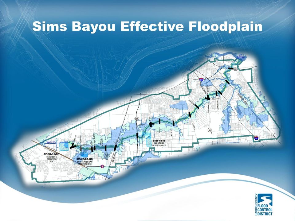
12 Sims Bayou Effective Floodplain
13 Flood Damages (Prior to Construction) Sims Bayou Project Sims Bayou near Buffalo Speedway 2001


14 Sims Bayou Post Project Floodplain Green = Area removed from 1% Floodplain


15 Sims Bayou Federal Flood Damage Reduction Project Project Benefits Removes floodplain from 35,000 homes and 2,000 businesses 1% event within channel banks for most of main stem Benefit to Cost Ratio of 6.5

16 with appropriate regard for community and natural values. Sims Bayou Flood Damage Reduction Project

17 Articulating Concrete Block Channel Lining

18 Sims Bayou Federal Flood Damage Reduction Project Articulating Concrete Block Downstream of Heatherbrook 5/03/11

19 Sims Bayou Federal Flood Damage Reduction Project Shortly after segment completion June 2011

20 Sims Bayou Federal Flood Damage Reduction Project Upstream of Scott Street

21 Sims Bayou Federal Flood Damage Reduction Project Upstream of Scott Street - Complete
22 Sims Bayou Federal Flood Damage Reduction Project Upstream of Scott St. - Complete
23 Sims Bayou Federal Flood Damage Reduction Project Completed Channel Section Upstream of Bellfort
24 Bridge Aesthetics


25 Bridge Aesthetics
26 Bridge Aesthetics Buffalo Speedway Bridge - Completed 2009
27 Bridge Aesthetics White Heather Bridge - Completed 2011
28 Bridge Aesthetics Buxley Pedestrian Bridge - Completed 2012
29 Bridge Aesthetics Heatherbrook Bridge - Completed 2012
30 Bridge Aesthetics Croquet Bridge - Completed 2013
31 Tree Planting
32 Tree Planting Allowable Tree Density 49 trees per acre on top bank 14 trees per acre on upper slope
33 Tree Planting Downstream of SH 288
34 Tree Planting Upstream of I-45
35 Oxbow Wetland Establishment
36 Oxbow Restoration Bellfort Oxbow Tree & Native Grass Plantings
37 Oxbow Wetland Establishment Bellfort Oxbow
38 Oxbow Wetland Establishment Oxbow Across from Stewart Park
39 Oxbow Wetland Establishment Oxbow Across from Stewart Park
40 Designed to Accommodate Future Recreation Trails
41 Designed to Accommodate Future Recreation Trails Replaced Existing Trails During Construction
42 Sims Bayou Regional Plan Local Funded Supplement to the Federal Project

43 Sims Bayou Federal Flood Damage Reduction Project
44 Sims Bayou Regional Plan Local Funded Supplement to the Federal Project 3 Detention sites purchased totaling 700 acres at a cost of $6.1M. Over 3.6 million cubic yards excavated from the 3 sites. Augments the Sims Federal Project to bring it close to 1% protection
45 Sims Bayou Regional Plan C S. Post Oak Basin C Blue Ridge Basin
46
47 Sims Bayou Regional Plan Channel Construction The Hill at Sims Detention Basin
48 Sims Bayou Federal Flood Damage Reduction Project 1% Floodplain removed from 35,000 homes and 2,000 businesses
49
Mission Creek Flood Control & Restoration Project. City of Fremont, Alameda County
 Mission Creek Flood Control & Restoration Project City of Fremont, Alameda County Agenda Background Why are proposed improvements necessary? Proposed project components Challenges Construction schedule/phasing
Harris County Flood Control District. Policy, Criteria, and Procedure Manual
 Harris County Flood Control District Policy, Criteria, and Procedure Manual For Approval and Acceptance of Infrastructure General Review October 10, 2003 Draft Please Provide Written Comments to the HCFCD
Flood Risk Management
 Flood Risk Management Value of Flood Risk Management Every year floods sweep through communities across the United States taking lives, destroying property, shutting down businesses, harming the environment
Flood Risk Management
 Flood Risk Management Value of Flood Risk Management Value to Individuals and Communities Every year floods sweep through communities across the United States taking lives, destroying property, shutting
Tres Rios del Norte Feasibility Study
 Tres Rios del Norte Feasibility Study Santa Cruz River Pima County, Arizona February 2011 Study Area: 18 Miles of Santa Cruz River (Prince to Sanders), portions of City of Tucson, Town of Marana, and unincorporated
A Presentation to the Houston Hispanic Architects and Engineers
 A Presentation to the Houston Hispanic Architects and Engineers Alan J. Potok, P.E. Director, Engineering and Construction Division Harris County Flood Control District February 6, 2014 Agenda Overview
Rhode Island NRCS received approximately $2.4 million in ARRA funds to implement four floodplain easement projects.
 American Recovery and Reinvestment Act (ARRA) Emergency Watershed Protection Program Floodplain Easements Rhode Island Natural Resources Conservation Service Rhode Island NRCS received approximately $2.4
Upper Des Plaines River & Tributaries, IL & WI Feasibility Study
 Upper Des Plaines River & Tributaries, IL & WI Feasibility Study Jeffrey Zuercher Project Manager Chicago District February 19, 2014 Study Partnership: US Army Corps of Engineers Agenda Background Study
1.7.0 Floodplain Modification Criteria
 1.7.0 Floodplain Modification Criteria 1.7.1 Introduction These guidelines set out standards for evaluating and processing proposed modifications of the 100- year floodplain with the following objectives:
The Basics of Chapter 105 Waterways and Wetlands Permitting in PA
 The Basics of Chapter 105 Waterways and Wetlands Permitting in PA April 17, 2013 Goal To develop a basic understanding of PA Department of Environmental Protection (DEP) and US Army Corps of Engineers
Public Law 84-99 and Non-Structural Alternatives to Levee Repairs
 Public Law 84-99 and Non-Structural Alternatives to Levee Repairs Presented by: Mr. Jerry A. Skalak, CFM U.S. Army Corps of Engineers Rock Island District and Mr. Tom Oswald Iowa Homeland Security and
CLACKAMAS COUNTY ZONING AND DEVELOPMENT ORDINANCE
 1008 STORM DRAINAGE (3/24/05) 1008.01 PURPOSE To minimize the amount of stormwater runoff resulting from development utilizing nonstructural controls where possible, maintain and improve water quality,
Emergency Streambank Restoration/Stabilization. Kentucky Division of Water Water Quality Certification May 2010 Educational Assistance
 Emergency Streambank Restoration/Stabilization Kentucky Division of Water Water Quality Certification May 2010 Educational Assistance Due to the severity of the recent rains and flooding occurrences, the
TROPICAL STORM ALLISON. Prepared by: John P. Ivey, PE, CFM Halff Associates, Inc. ASCE
 TROPICAL STORM ALLISON June 5-9, 5 2001 Prepared by: John P. Ivey, PE, CFM Halff Associates, Inc. ASCE Spring 2002 Meeting Arlington, Texas March 27-30, 2002 Tropical Storm Allison (TSA) The most extensive
Swannanoa River Flood Risk Management Study
 Swannanoa River Flood Risk Management Study Measures Evaluated to Reduce Future Flood Damages City of Asheville U.S. Army Corps of Engineers Flooding History Part of the 132 square mile Swannanoa River
CITY UTILITIES DESIGN STANDARDS MANUAL
 CITY UTILITIES DESIGN STANDARDS MANUAL Book 2 (SW) SW9 June 2015 SW9.01 Purpose This Chapter provides information for the design of open channels for the conveyance of stormwater in the City of Fort Wayne.
DRAFT SOUTH FORK SKYKOMISH RIVER
 DRAFT SOUTH FORK SKYKOMISH RIVER 9 levees and revetments / Approximately 1.1 miles of river bank are armored Revetments provide limited, localized erosion protection, but impact habitat Frequent and costly
Aligning Natural and Built Infrastructure for
 Aligning Natural and Built Infrastructure for Houston Climate Resilience National Exercise Program (NEP) Houston Climate Change Preparedness & Resilience Workshop Edmond J. Russo, Jr., PhD, PE, D.CE, D.NE,
The Everglades & Northern Estuaries; St. Lucie River Estuary, Indian River Lagoon & Caloosahatchee Estuary. Water Flows & Current Issues
 The Everglades & Northern Estuaries; St. Lucie River Estuary, Indian River Lagoon & Caloosahatchee Estuary Water Flows & Current Issues Florida Governor Rick Scott August 20, 2013 Upper Chain of Lakes
Chapter 3 SENSITIVE AREAS AND VEGETATED CORRIDORS
 Chapter 3 3.01 General Provisions 3.01.1 Introduction 3.01.2 Application and Interpretation of Chapter 3.01.3 Unbuildable Lots 3.01.4 Other Permits 3.01.5 Prohibited Activities 3.02 Service Provider Letter
HCP Team Meeting. November 18, 2015. icfi.com
 HCP Team Meeting November 18, 2015 icfi.com 1 Welcome and Introductions Where are we in the HCP process Hydrology modeling update Native fish survey Fish translocation Finalize covered activities Next
The Teton Creek Restoration Project Summary:
 The Teton Creek Restoration Project Summary: The Teton Creek Restoration Project area extends for approximately one mile upstream from the Cemetery Road Bridge and includes the Aspen Pointe, The Aspens
PUBLIC NOTICE Application for Permit
 PUBLIC NOTICE Application for Permit 30-Day Notice Issue Date: June 20, 2016 Expiration Date: July 20, 2016 US Army Corps of Engineers No: NWP-2010-535 Oregon Department of State Lands No: 58311-RF Interested
Urban Stream Restoration Defining the Full Benefits of a Project. Warren C. High MACTEC Engineering and Consulting
 Urban Stream Restoration Defining the Full Benefits of a Project Warren C. High MACTEC Engineering and Consulting Economics in the Decision Process Return on Investment Willingness to Pay Municipal Growth
Community Workshop 5. Overarching Goals for Machado Lake Ecosystem and Wilmington Drain Multi-Use Projects
 City of Los Angeles Department of Public Works Bureau of Engineering Machado Lake Ecosystem Rehabilitation Project & Wilmington Drain Multi-Use Project Community Workshop 5 February 24, 2009 In association
SCHNEIDER CREEK REMEDIATION CLASS ENVIRONMENTAL ASSESSMENT ADDENDUM
 SCHNEIDER CREEK REMEDIATION CLASS ENVIRONMENTAL ASSESSMENT ADDENDUM PUBLIC MEETING FEBRUARY 8 TH, 2012 The City of Kitchener and Grand River Conservation Authority (GRCA) are undertaking an Environmental
Liquid Capital. Cochran s Creek: A Case Study in Stream Mitigation Banking in Georgia
 Liquid Capital Cochran s Creek: A Case Study in Stream Mitigation Banking in Georgia Basic Bank Permitting Process Submit Prospectus to IRT. If approved then: Conduct site visit with IRT. If approved then:
Mission Reach Self-Guided Tour Mission Concepción Portal Loop and Mission Reach Phase II Embayment Loop
 Mission Reach Self-Guided Tour Mission Concepción Portal Loop and Mission Reach Phase II Embayment Loop Welcome to the Mission Reach! The Mission Reach Ecosystem Restoration and Recreation Project is transforming
Chehalis River Basin Flood Damage Reduction 2013-2015 Capital Budget Approved by Legislature in June 2013
 Chehalis River Basin Flood Damage Reduction 2013-2015 Capital Budget Approved by Legislature in June 2013 1. Design alternatives for large capital flood projects (basinlevel water retention and Interstate
Proposed General Plan Update Goals, Policies, and Implementation Actions
 Proposed General Plan Update Goals, Policies, and Implementation Actions The construction and maintenance of infrastructure is necessary to support existing and planned land uses and to achieve Environmental
Appendix A. Lists of Accomplishments and Project Costs. UMRWD 10 Year Plan Update. Appendix A UPPER MINNESOTA RIVER WATERSHED DISTRICT
 UPPER MINNESOTA RIVER WATERSHED DISTRICT Lists of Accomplishments and Project Costs 10 Year Plan Update UMRWD 10 Year Plan Update Page A 1 UMRWD LIST OF ACCOMPLISHMENTS Since its inception in 1967, the
Flood Damage Prevention in Delaware County, NY
 Flood Damage Prevention in Delaware County, NY Susquehanna Basin 2 Villages, 8 Hamlets Schoharie Basin 1 Hamlet Cannonsville Basin 4 Villages, 6 Hamlets Pepacton Basin 2 Villages, 6 Hamlets Upper Delaware
Background Information: The Mamquam River Floodplain Restoration Project
 Background Information: The Mamquam River Floodplain Restoration Project The Mamquam River Floodplain Restoration project is being undertaken in partnership with the Squamish River Watershed Society, Fisheries
13. ENVIRONMENTAL PROTECTION/ RESOURCE MANAGEMENT
 13. ENVIRONMENTAL PROTECTION/ RESOURCE MANAGEMENT A. Existing Conditions Ramsey is fortunate to have an ample amount of natural resources and open space areas and a community attitude that is increasingly
ESRI_UC_2015_No843_Integrating Flood Risk Management and Salmon Habitat Restoration_CampbellSW
 ESRI_UC_2015_No843_Integrating Flood Risk Management and Salmon Habitat Restoration_CampbellSW Advancing an integrated approach to flood risk management and habitat restoration planning in the Puget Sound
ELMER AVENUE. Water Augmentation Study NEIGHBORHOOD RETROFIT DEMONSTRATION PROJECT
 ELMER AVENUE Water Augmentation Study NEIGHBORHOOD RETROFIT DEMONSTRATION PROJECT STAGG STREET ELMER AVENUE KESWICK STREET PASEO NOTE: Photo taken before retrofit WHAT IS THE NEIGHBORHOOD RETROFIT PROJECT?
Tookany Creek Flood Damage Reduction Feasibility Study Section 205 Continuing Authorities Program
 Tookany Creek Flood Damage Reduction Feasibility Study Section 205 Continuing Authorities Program Field Inspection Notes 27 29 September 2012 Introduction The U.S. Army Corps of Engineers (Corps), in
Urban Waters and River Restoration. Pinja Kasvio, Finnish Environment Institute, SYKE RESTORE North Region Closing Seminar 14.8.
 Urban Waters and River Restoration Pinja Kasvio, Finnish Environment Institute, SYKE RESTORE North Region Closing Seminar 14.8.2013 Urban Waters Hålland, Gässlösa (Sweden) Characteristics of urban areas:
MEMORANDUM OF AGREEMENT Between THE CITY OF BALTIMORE And THE MID-ATLANTIC FEDERAL PARTNERSHIP FOR THE ENVIRONMENT
 MEMORANDUM OF AGREEMENT Between THE CITY OF BALTIMORE And THE MID-ATLANTIC FEDERAL PARTNERSHIP FOR THE ENVIRONMENT The Mid-Atlantic Federal Partnership for the Environment ( MAFPE ) and the City of Baltimore
LEAGUE NOTES ON APPROVED COMMUNITY WATER SUPPLY PLAN
 1 AUGUST 2011 LEAGUE NOTES ON APPROVED COMMUNITY WATER SUPPLY PLAN KEY ELEMENTS OF THE PLAN: 1. Replace the existing unsafe Ragged Mountain dam with a new dam and raise the reservoir pool level initially
US Army Corps of Engineers Los Angeles District. Rio Salado Oeste Salt River-Phoenix, Arizona FEASIBILITY REPORT SUMMARY
 US Army Corps of Engineers Los Angeles District Rio Salado Oeste Salt River-Phoenix, Arizona FEASIBILITY REPORT SUMMARY U.S. Army Corps of Engineers South Pacific Division, Los Angeles District September
Lower Raritan Watershed Management Area Stormwater & Flooding Subcommittee Strategy Worksheet LRSW-S3C1
 Strategy Name: Reduce Existing Potential for Flood Damages LRSW-S3C1. Develop and implement a program to: Minimize flood damages through the use of structural measures. Minimize flood damages through the
Peters Canyon Channel (OCFCD Facility No. F06) from Confluence with San Diego Creek Channel (F05) to downstream Barranca Parkway
 from Confluence with San Diego Creek Channel (F05) to downstream Barranca Parkway") Peters Canyon Channel (OCFCD Facility. F06) from Lead Agency: Agency: Project Director: Address: Orange County, Public Works, Infrastructure Programs, Capital Programs Sam Ali 300 N. Flower Street Santa
Peters Canyon Channel (OCFCD Facility. F06) from Lead Agency: Agency: Project Director: Address: Orange County, Public Works, Infrastructure Programs, Capital Programs Sam Ali 300 N. Flower Street Santa
Introduction to the Envision Sustainability Rating System
 THE ENVISION RATING SYSTEM Introduction to the Envision Sustainability Rating System Russell Moore, PE, ENV SP Richard Gomez, PE, MSEM, ENV SP test APWA Public Works Conference Richmond, CA November 2015
Floodplain Development Land Use Review
 COMMUNITY DEVELOPMENT DEPARTMENT Planning Division P.O. Box 490 333 Broadalbin Street SW Albany, OR 97321 Phone 541-917-7550 Fax 541-791-0150 www.cityofalbany.net Floodplain Development Land Use Review
1 Introduction. 1.1 Key objective. 1.2 Why the South Esk
 1 Introduction 1.1 Key objective The aim of this study is to identify and assess possible options for improving the quality of the river channel and habitats in the River South Esk catchment whilst helping
Carlton Fields Memorandum
 Carlton Fields Memorandum TO: FROM: RE: DAN WEEDE FRED RUSHING RIPARIAN BUFFER DATE: JULY 26, 2013 BACKGROUND Both the state of Georgia and the city of Atlanta 1 have certain guidelines that must be followed
Ecosystem Services, Wetlands and Houston s Growth. Jim Lester
 Ecosystem Services, Wetlands and Houston s Growth Jim Lester Definitions (MEA 2005) Ecosystem: a dynamic complex of plant, animal, and microorganism communities and the nonliving environment interacting
Fort Dodge Stormwater Master Planning. Prepared By: Ralph C. Stark, Jr., P.E., C.F.M. Joel N. Krause, P.E., C.F.M.
 Fort Dodge Stormwater Master Planning Prepared By: Ralph C. Stark, Jr., P.E., C.F.M. Joel N. Krause, P.E., C.F.M. Project Location Project Background Flooding History Localized flooding and storm sewer
SECTION 108 - INLETS 108.1 INLET LOCATIONS
 Greene County Design Standards -Adopted April 5, 1999 SECTION 108 - INLETS SECTION 108 - INLETS 108.1 INLET LOCATIONS 108.2 INLET INTERCEPTION CAPACITIES 108.2.1 Clogging Factors 108.3 INTERCEPTION AND
IMPROVING SOUTH FORK PEACHTREE CREEK WATERSHED USING THE TRIPLE BOTTOM LINE DEKALB COUNTY, GEORGIA
 IMPROVING SOUTH FORK PEACHTREE CREEK WATERSHED USING THE TRIPLE BOTTOM LINE DEKALB COUNTY, GEORGIA David Chastant AUTHORS:DeKalb County, 330 West Ponce De Leon Ave, Decatur, Georgia 30030 REFERENCE:Proceedings
ANGORA FIRE RESTORATION PROJECT
 ANGORA FIRE RESTORATION PROJECT U.S. Forest Service LAKE TAHOE BASIN MANAGEMENT UNIT Duncan Leao Vegetation Management Planner Richard Vacirca Forest Aquatics Biologist 3 PHASES OF FIRE REHAB Phase I Rehab:
Final Report. Dixie Creek Restoration Project. Funded by Plumas Watershed Forum
 Final Report Dixie Creek Restoration Project Funded by Plumas Watershed Forum Plumas Corporation January 2009 1 Background FR-CRM staff presented this project to the Dixie Valley Landowners Association
Muddy River Restoration Project Project Description
 Muddy River Restoration Project Project Description Since the fall of 1996, the Muddy River has flooded three times, causing damage to residents, businesses institutions and the public transit system in
Flood Plain Reclamation to Enhance Resiliency Conserving Land in Urban New Jersey
 Flood Plain Reclamation to Enhance Resiliency Conserving Land in Urban New Jersey Rutgers Cooperative Extension Water Resources Program Christopher C. Obropta, Ph.D., P.E. Email: [email protected]
3.4 DRAINAGE PLAN. 3.4.1 Characteristics of Existing Drainages. 3.4.2 Master Drainage System. Section 3: Development Plan BUTTERFIELD SPECIFIC PLAN
 3.4 DRAINAGE PLAN This section describes the existing onsite drainage characteristics and improvements proposed within this Specific Plan. Following this description, drainage plan development standards
AN INITIATIVE TO IMPROVE
 L OW E R C A R M E L R I V E R A N D L AG O O N F L O O D P L A I N R E S TO R AT I O N A N D E N H A N C E M E N T P R O J E C T AN INITIATIVE TO IMPROVE FLOOD PROTECTION RESTORE AND PROTECT RIPARIAN
2012 Program Report. Agricultural Group Drainage Program
 2012 Program Report Agricultural Group Drainage Program Accomplishments: It was a successful year for the drainage program. We were able to complete two new projects and seven maintenance projects throughout
Environmental Case Study Decatur, Georgia, DeKalb County A Suburban Creek Resists Channelization
 Introduction A visual examination of Doolittle Creek in a highly developed suburban county in Georgia yielded telltale signs of a creek whose original streambed had been altered. Examination of official
Land Disturbance, Erosion Control and Stormwater Management Checklist. Walworth County Land Conservation Department
 Land Disturbance, Erosion Control and Stormwater Management Checklist Walworth County Land Conservation Department The following checklist is designed to assist the applicant in complying with the Walworth
What Is Rehabilitation?
 Location of Aggregate Operations Ready Mix Plant Locations Aggregate Locations Cement Terminal Locations What Is Rehabilitation? Rehabilitation is the treatment of land from which aggregate has been excavated
WATER QUALITY MODELING TO SUPPORT THE ROUGE RIVER RESTORATION
 WATER QUALITY MODELING TO SUPPORT THE ROUGE RIVER RESTORATION Edward H. Kluitenberg, P.E., Applied Science, Inc. Gary W. Mercer, P.E., Camp, Dresser and McKee Vyto Kaunelis, Wayne County Department of
San Francisco Bay Area Wetlands Restoration Program Design Review Group. Project Summary Outline
 San Francisco Bay Area Wetlands Restoration Program Design Review Group Project Summary Outline The project proponent desiring to have a project considered by the Design Review Group (DRG) shall provide
ESCAMBIA COUNTY FLOOD RECOVERY: 1- YEAR ANNIVERSARY REPORT
 Joy D. Blackmon, P.E. Director, County Engineer Public Works Department ESCAMBIA COUNTY FLOOD RECOVERY: 1- YEAR ANNIVERSARY REPORT EXECUTIVE SUMMARY One year after the devastating April 2014 floods hit
San Diego Integrated Regional Water Management Implementation Grant Proposal Economic Analysis Flood Damage Reduction Costs and Benefits
 Attachment 9 San Diego Integrated Regional Water Management Economic Analysis Flood Damage Reduction Costs and Benefits Attachment 9 consists of the following items: Flood Damage Reduction Costs and Benefits.
Develop hazard mitigation policies and programs designed to reduce the impact of natural and human-caused hazards on people and property.
 6.0 Mitigation Strategy Introduction A mitigation strategy provides participating counties and municipalities in the H-GAC planning area with the basis for action. Based on the findings of the Risk Assessment
Revegetation of a Detention Basin in Harris County, Texas: Lessons Learned
 Revegetation of a Detention Basin in Harris County, Texas: Lessons Learned Sherri Dunlap Harris County Flood Control District, 9900 Northwest Freeway, Houston, Texas 77092 713-684-4181 (phone), 713-684-4140
PUBLIC INFORMATIONAL MEETING THURSDAY APRIL 30, 2015
 PUBLIC INFORMATIONAL MEETING THURSDAY APRIL 30, 2015 AT ACTON TOWN HALL FAULKNER ROOM 472 MAIN STREET ACTON, MASSACHUSETTS 7:00 PM FOR THE PROPOSED ASSABET RIVER RAIL TRAIL (ARRT) IN THE TOWNS OF ACTON
Haynes Recreation Center, Laredo, TX. Data Matrix and Sustainability Benchmarks
 Haynes Recreation Center, Laredo, TX Data Matrix and Sustainability Benchmarks (Updated Spring 2010) 1 Standard Benchmarks BENCHMARKS UNITS PRE PROJECT GOAL Property value (pre/post) Assessed or redevelopment
CITY OF HIGHLAND PARK, ILLINOIS Stormwater Management Fact Sheet
 CITY OF HIGHLAND PARK, ILLINOIS Stormwater Management Fact Sheet WHAT IS STORMWATER MANAGEMENT? Stormwater management is the method for channeling rainfall through pipes and sewers away from property to
How To Amend A Stormwater Ordinance
 Regulatory Alternatives to Address Stormwater Management and Flooding in the Marlboro Street Study Area Alternative 1: Amend Existing Local Regulations This proposed alternative provides an incremental
ROSE CREEK WATERSHED HYDROLOGIC, HYDRAULIC, SEDIMENT TRANSPORT, AND GEOMORPHIC ANALYSES TASK 1 EXISTING DATA AND INFORMATION SUMMARY REPORT BACKGROUND
 ROSE CREEK WATERSHED HYDROLOGIC, HYDRAULIC, SEDIMENT TRANSPORT, AND GEOMORPHIC ANALYSES TASK 1 EXISTING DATA AND INFORMATION SUMMARY REPORT BACKGROUND The Rose Creek Watershed (RCW) consists of three planning
Westerly Creek, A Poster Child for Understanding the Benefit of Stormwater Investment
 Westerly Creek, A Poster Child for Understanding the Benefit of Stormwater Investment Presented at the ASFPM Annual Conference Atlanta, GA June 1 June 5 2015 Jon Villines, EIT, CFM Aurora Water Alan Turner,
Ecosystem Services in the Greater Houston Region. A case study analysis and recommendations for policy initiatives
 Ecosystem Services in the Greater Houston Region A case study analysis and recommendations for policy initiatives Ecosystem Services Ecosystems provide services through their natural processes that we
The Muddy River: A Century of Change
 The Muddy River: A Century of Change Tom Brady, Brookline Conservation Administrator, Tree Warden, Town Arborist 617-730-2088 or [email protected] Muddy River Flood Damage Reduction and Environmental
PLANNED UNIT DEVELOPMENT & SIDEWALK WAIVER REQUEST STAFF REPORT Date: November 7, 2013
 PLANNED UNIT DEVELOPMENT & SIDEWALK WAIVER REQUEST STAFF REPORT Date: November 7, 2013 NAME LOCATION Audubon Properties, LLC. 4700 & 4960 Dauphin Island Parkway West side of Dauphin Island Parkway, 580
US Army Corps of Engineers BUILDING STRONG
 Fort Worth District Public Meeting 20 August 2013 US Army Corps of Engineers Lewisville Dam - Authorization Authorized by the River and Harbor Act, approved 2 March 1945 (Public Law 14, 79th Congress,
Clean Water Services. Ecosystems Services Case Study: Tualatin River, Washington
 Viewed broadly, the concept of ecosystem services describes the many resources and services provided by nature. Typically, traditional planning and development practices do not adequately represent the
5.0 OVERVIEW OF FLOOD DAMAGE REDUCTION MEASURES
 5.0 OVERVIEW OF FLOOD DAMAGE REDUCTION MEASURES Flood damage reduction consists of two basic techniques structural and non-structural. Structural methods modify the flood and take the flood away from people
Interim Technical Guidelines for the Development of Environmental Management Plans for Underground Infrastructure Revised - July 2013.
 Interim Technical Guidelines for the Development of Environmental Management Plans for Underground Infrastructure Revised - July 2013 Rationale Underground infrastructure may be at risk from valley, streambank
ELIMINATE STORM WATER FROM ENTERING SANITARY SEWER SYSTEMS
 (408) 761 5882 http://www.sewerlock.net ELIMINATE STORM WATER FROM ENTERING SANITARY SEWER SYSTEMS 1. `The United States and various State Environmental Protection Agency regulations require elimination
Cellular Antenna Proposal Form
 Cellular Antenna Proposal Form Islands Trust, Northern Office 700 North Road, Gabriola Island, BC V0R 1X3 Phone: 250-247-2063 Fax: 250-247-7514 www.islandstrust.bc.ca [email protected] Be sure
U.S. Army Corps of Engineers Tulsa District
 U.S. Army Corps of Engineers Tulsa District Mike Abate, PMP. Chief, Civil Works Branch, PPMD April 17, 2015 US Army Corps of Engineers Civil Works Mission Water Supply 50% of Corps water supply contracts
BINGHAMTON FLOOD DAMAGE REDUCTION PROJECT
 BINGHAMTON FLOOD DAMAGE REDUCTION PROJECT Department of Environmental Conservation Region 7 Counties: Broome, Cayuga, Chenango, Cortland, Madison, Onondaga, Oswego, Tioga, Tompkins Operated and Maintained
US Army Corps of Engineers Authorities and Programs
 US Army Corps of Engineers Authorities and Programs Section 206; Flood Plain Management Services Program Section 22; Planning assistance to States General Investigations (large-scale flood risk reduction)
Glen Hills Area: Septic System and Public Sewer Q & A Information Sheet Page 1
 Glen Hills Area: Septic System and Public Sewer Q & A Information Sheet Page 1 The Montgomery County Dept. of Environmental Protection, in cooperation with the Dept. of Permitting Services and the Washington