TROPICAL STORM ALLISON. Prepared by: John P. Ivey, PE, CFM Halff Associates, Inc. ASCE
|
|
|
- Marilyn Reynolds
- 9 years ago
- Views:
Transcription
1 TROPICAL STORM ALLISON June 5-9, Prepared by: John P. Ivey, PE, CFM Halff Associates, Inc. ASCE Spring 2002 Meeting Arlington, Texas March 27-30, 2002

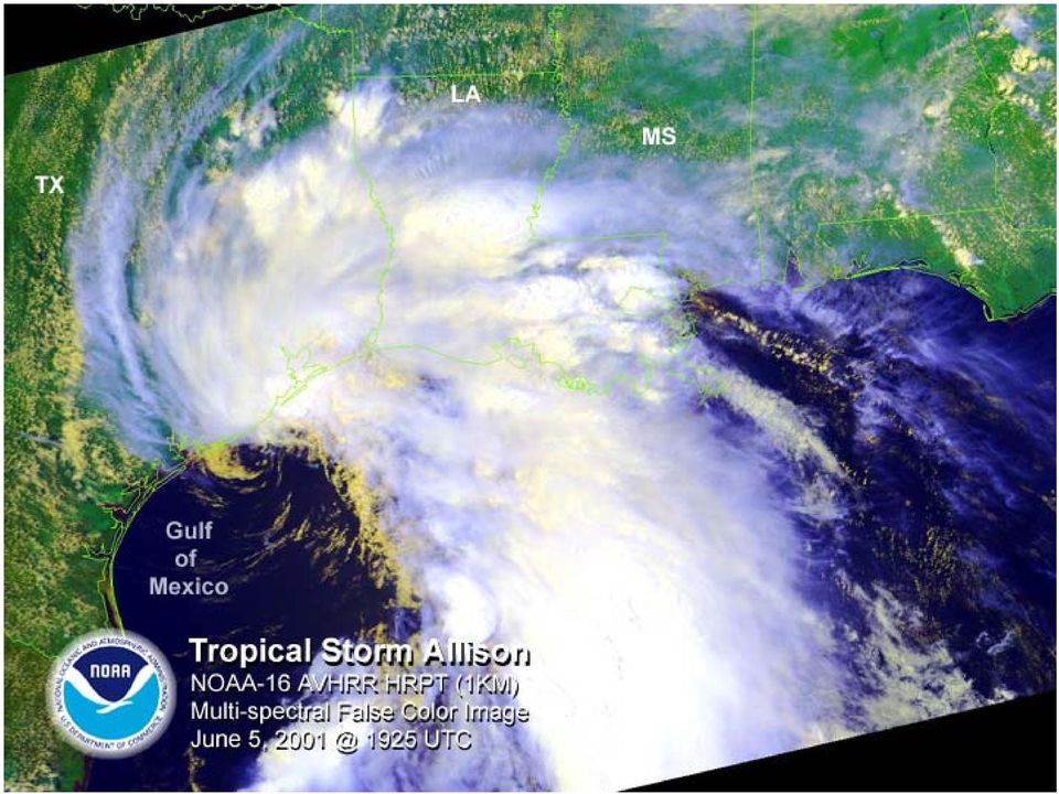
2 Tropical Storm Allison (TSA) The most extensive tropical storm in US history First Named Storm of the 2001 Atlantic Hurricane Season First tropical storm to strike the upper Texas coast since Francis in More deadly than Hurricane Alicia (22 lives lost with Allison). Allison caused 43 deaths nationwide. Tropical Storm Claudette holds national rainfall record of 43 in a 24-hour period. Tropical Storm Allison is close behind with at the Port of Houston and at Thibodaux, LA. TSA Rainfall exceeded 500-year intensity in 2/3 of Harris County s 22 watersheds.

3 TSA (continued) The maximum rainfall rate recorded in the Greens Bayou watershed was 28.5 in a 10.5 hour period where the PMP is estimated to be 32.5 in a 12 hour period. 73,000 residences and 95,000 automobiles were flooded. Damages exceed $5B. NFIP has paid over 30,000 flood damage claims in Texas and Louisiana for over $1B. Allison flooded portions of Texas, Louisiana, Mississippi, Alabama, Georgia, Florida, North Carolina, Pennsylvania, and Virginia

4 TSA (continued) The average annual rainfall for Houston is inches and the first nine days in June 2001 produced 35.7% of the annual expected rainfall. Thanks to excellent flood forecasting and warning there were no drowning deaths in flooded homes. This is remarkable with over 73,000 flooded homes. The 22 deaths in Houston related to TSA: 12 driving 6 walking 3 electrocutions 1 elevator

5 TSA (continued) Prior to TSA, the Harris County Flood Control District (HCFCD) completed over $4 Billion in structural and non-structural flood control projects. Over the past 12 years HCFCD purchased 440 properties at a cost of $40M. Approximately 1600 Harris County Repetitive Loss Properties have been identified for fast track acquisition and relocation after TSA. The Galveston District COE estimates that over $246M in damages were prevented by Federal Flood Control Projects in Harris County during TSA.

6 National Weather Service Harris County Office of Emergency Management USGS Real Time Flow FEMA TNRCC TSA (continued) Allison was perhaps the best documented disaster event in US history due to utilization of the Web.

7 TxDEM Harris County FIRMs NGS Benchmark Data Sheets USGS Topographic Maps TSA (continued) NWS Allison Report Texas General Land Office
 NWS Allison Report www.srh.noaa.")
8 TSA (continued) NWS Web page 01.htm This Web site includes rainfall, flood photos and a link to the NWS Service Assessment. I commend the NWS for producing an excellent storm report.

9 TSA (continued) President Bush declared 30 Texas counties a Disaster Area immediately following the flood event. Disaster Response by Federal and State Agencies. Jack Quarles, PE, and Gary Zimmerer, PE, lead the FEMA Technical Services Team. HCFCD utilized it s Cooperative Technical Partner (CTP) with FEMA to assist local communities in the flood recovery process. FEMA utilized the HCFCD - Harris County Map Assessment as justification to restudy and the 142 DFIRM panels covering 35 communities in Harris County. FEMA and Harris County Flood Control District (HCFCD) initiated the Tropical Storm Allison Flood Recovery Project (TSARP).

10 TSA (continued) The Tropical Storm Allison Flood Recovery Project (TSARP) is a fast track effort that includes: Harris County Flood Control District survey teams preparation of inundation maps and surveying high water marks during and immediately following TSA Harris County Map Needs Assessment and Map Needs Update Support System (MNUSS) database National Weather Service Tropical Storm Allison Flood Report and Service Assessment Substantial Damage Determinations to fast track Acquisition and Relocation Project of approximately 1600 repetitive loss properties

11 Funding, selection of consultants, and initiation of TSARP with an initial estimate of $16.5M Creation of a Website Public Meetings and Press Events New County-Wide LIDAR Mapping (12 cm+/-) Base map preparation using HGAC STAR-Map Hydrology analysis of 22 watersheds (1750 sq.mi.) Post Event Analysis TSA (continued) NGS efforts to re-level 1 st order 2000 Datum bench marks Documentation of subsidence measurements

12 Field surveys of over 10,000 channel cross sections Utilize LIDAR to define floodplain in overbank areas Hydraulic Analysis of 202 studied streams (1,200 stream miles) Digital Floodplain Mapping DFIRM panels Four (4) major committees (Executive, Technical, Stakeholders and Users) Draft (Preliminary) FIS and FIRM s Public Review TSA (continued) Resolution of Technical Appeals Final adoption of FIS and publication of DFIRM s (Target date is June 2004)
 Resolution of Technical Appeals Final adoption of FIS and publication of DFIRM s (Target date is June")
13
14 Buffalo Bayou White Oak Bayou Confluence and Main St. 6/9/01 am

15 Buffalo Bayou, Looking upstream from Main St. 6/9/01

16 Clear Creek, Gulf Meadows Subdivision 6/6/01

17 Clear Creek, Green Tee Terrace Subdivision 6/6/01

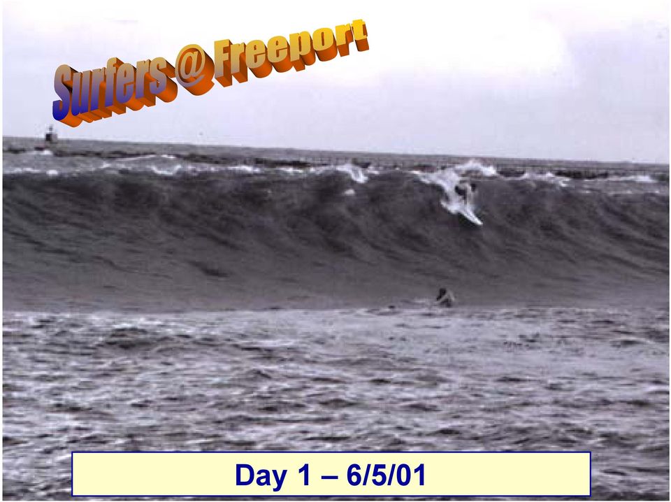
18 Day 1 6/5/01
19 Day 1 June 5, Friendswood

20 Day 2 June 6, Friendswood

21 Day 3 June 7, Friendswood
22 Day 4 June 8, Friendswood
23 Day 5 June 9, Friendswood
24 Friendswood (Clear Creek)
25 Greens Bayou, Home Owned Estates 6/10/01 pm
26 Halls Bayou, People at a store all night 6/9/01 am
27 US Hazard Street Overpass 6/09/01
28 Hunting Bayou, I-10-6/9/01 am
29 Hunting Bayou, Holiday Forest 6/9/01 am
30 Hunting Bayou, Kashmere Gardens with Downtown Skyline - 6/9/01 am
31 Hunting Bayou, Wastewater Treatment Plant, North Loop - 6/9/01 am
32 Hunting Bayou, Tank Farm - 6/9/01 am
33 San Jacinto River, Forest Cove 6/9/01 am
34 Buffalo Bayou Downtown Tunnel 6/09/01
35 Buffalo Bayou Downtown Tunnel 6/09/01
36 Upper Sims Bayou, Meredith Manor Subdivision - 6/9/01
37 White Oak Bayou, Looking Upstream from W. 11th - 6/9/01 am
38 White Oak Bayou, Heights Blvd. 6/9/01 am
39 White Oak Bayou, I-45 and I-10 Interchange, Downtown - 6/9/01 am
40 Island Inn
41 TROPICAL STORM ALLISON Only 43 lives were lost during Tropical Storm Allison because of the Federal, State and Local Agencies, and Emergency Response Personnel, that risked their lives to warn, rescue and protect the Public. This paper is a tribute to them.
42 TROPICAL STORM ALLISON June 5-9, Prepared by: John P. Ivey, PE, CFM Halff Associates, Inc. ASCE Spring 2002 Meeting Arlington, Texas March 27-30, 2002
Tropical Storm Allison and its impact on Harris County
 UNIVERSITY OF TEXAS AT AUSTIN CE 394K GIS in Water Resources Binbin Chen December 9, 2006 Tropical Storm Allison and its impact on Harris County Background Tropical Strom Allison Recovery Project Project
Tropical Storm Allison 2001
 Texas State Senate Subcommittee on Flooding and Evacuations Testimony of Robert Eckels 18 October 2010 The challenges of Hurricanes and Flooding can best be illustrated in the Tale of Two Storms. Tropical
CHICKASAW COUNTY, MISSISSIPPI, AND INCORPORATED AREAS
 CHICKASAW COUNTY, MISSISSIPPI, AND INCORPORATED AREAS Chickasaw County Community Name Community Number CHICKASAW COUNTY 280269 (UNINCORPORATED AREAS) HOUSTON, CITY OF 280030 NEW HOULKA, TOWN OF 280067
Section 19. Basin-wide Mitigation Action Plans
 Section 19. Basin-wide Mitigation Action Plans This Mitigation Plan identifies twelve specific hazards that could affect the Basin. Section 20 of this Plan set forth mitigation action plans to be carried
MAP TYPES FLOOD HAZARD BOUNDARY MAP MAP READING & FLOOD INSURANCE STUDIES. FHBM Flood Hazard Boundary Map. FIRM Flood Insurance Rate Map
 FLOODPLAIN MANAGEMENT 101 MAP READING & FLOOD INSURANCE STUDIES MAP TYPES FHBM Flood Hazard Boundary Map FIRM Flood Insurance Rate Map FBFM Flood Boundary and Floodway Map DFIRM Digital Flood Insurance
CFM REVIEW COURSE September 30, 2014 Vail, CO
 CFM REVIEW COURSE September 30, 2014 Vail, CO CFM PURPOSE The primary goal of the ASFPM Certified Floodplain Manager Program (CFM Program) is to help reduce the nation s flood losses and protect and enhance
Ecosystem Services, Wetlands and Houston s Growth. Jim Lester
 Ecosystem Services, Wetlands and Houston s Growth Jim Lester Definitions (MEA 2005) Ecosystem: a dynamic complex of plant, animal, and microorganism communities and the nonliving environment interacting
TABLE OF CONTENTS. This document was prepared by. URS Group, Inc. 200 Orchard Ridge Drive, Suite 101 Gaithersburg, MD 20878. In Association with:
 Delaware and Susquehanna River Basin Flood Data Assessment Pennsylvania May 2008 Federal Emergency Management Agency Department of Homeland Security 500 C Street, SW Washington, DC 20472 TABLE OF CONTENTS
Sims Bayou Federal Flood Damage Reduction Project
 Sims Bayou Federal Flood Damage Reduction Project A. Gene Rushing, Jr., P.E., PMP HCFCD Project Manager January 15, 2014 Harris County s Watersheds Historical Flooding in Harris County 1929 1935 HCFCD
SARASOTA COUNTY Dedicated to Quality Service
 SARASOTA COUNTY Dedicated to Quality Service Florida Flood Map Updates and the National Flood Insurance Program Joy Duperault, CFM State of Florida NFIP Coordinator Desiree (Des) Companion, CFM CRS Coordinator
Tradeoffs of Ecosystem Services from Wetlands in the Houston Region
 Tradeoffs of Ecosystem Services from Wetlands in the Houston Region L. James Lester 1, Gregory R. Biddinger 1 and Lisa A. Gonzalez 1 1 HARC, The Woodlands, TX, USA The Starting Point: ES Workshop Galveston
CRS 610 Ventura County Flood Warning System Website
 CRS 610 Ventura County Flood Warning System Website Purpose This document gives instructions and a description of the information available via the Ventura County Watershed Protection District s (VCWPD)
www.tsarp.org At the time of printing, all information in this report was current and known to be accurate.
 T R O P I C A L S T O R M A L L I S O N P U B L I C R E P O R T This report is a product of the Tropical Storm Allison Recovery Project, a partnership between the Federal Emergency Management Agency and
An Introduction to FEMA Flood Map Updates and How it Affects You
 An Introduction to FEMA Flood Map Updates and How it Affects You Presented by Michael Baker Jr., Inc. on behalf of the City of Reno Agenda Session 1 5:30-6:00 FEMA Flood Map Changes Program Slide Show
Why does Kittitas County want to form a Flood Control Zone District?
 KITTITAS COUNTY DEPARTMENT OF PUBLIC WORKS Kirk Holmes, Director What is a Flood Control Zone District (FCZD)? A Kittitas County Flood Control Zone District (FCZD) would be a special-purpose government
Los Angeles County. Open Pacific Coast Study. California Coastal Analysis and Mapping Project
 Los Angeles County Open Pacific Coast Study California Coastal Analysis and Mapping Project December 2011 Open Pacific Coast Counties Phase 1 Phase 2 California Coastal Analysis and Mapping Project Risk
Section 5 Floodplain Management Tools
 5.1 Floodprone Areas One of the major elements of the Master Plan is the updated 100-year floodplain and floodway boundary maps. This information provided the most up-to-date tools to protect homes and
Flood Management Handbook
 Flood Management Handbook REGIONAL FLOOD MANAGEMENT COUNCIL Houston-Galveston Area Council July 2009 REGIONAL FLOOD MANAGEMENT COUNCIL Flood Management Handbook Houston-Galveston Area Council 3555 Timmons
Overview of the National Flood Insurance Program (NFIP) and Recent Flood Mapping Efforts. Richard Zingarelli
 and Recent Flood Mapping Efforts. Richard Zingarelli") Overview of the National Flood Insurance Program (NFIP) and Recent Flood Mapping Efforts Richard Zingarelli State NFIP Program Coordinator Commonwealth of Massachusetts Department of Conservation and Recreation
Overview of the National Flood Insurance Program (NFIP) and Recent Flood Mapping Efforts Richard Zingarelli State NFIP Program Coordinator Commonwealth of Massachusetts Department of Conservation and Recreation
Mariana Leckner, Ph.D., Professor, American Military University Thomas O. Herrington, Ph.D. Associate Professor, Stevens Institute of Technology
 Mariana Leckner, Ph.D., Professor, American Military University Thomas O. Herrington, Ph.D. Associate Professor, Stevens Institute of Technology National Hydrologic Warning Council Training Conference
NEXRAD Flood Warning System and Floodplain Library For Houston, TX
 NEXRAD Flood Warning System and Floodplain Library For Houston, TX Z. Fang 1 and P. B. Bedient 2 1 Graduate Student, Department of Civil and Environmental Engineering, Rice University, 6100 Main Street,
Aligning Natural and Built Infrastructure for
 Aligning Natural and Built Infrastructure for Houston Climate Resilience National Exercise Program (NEP) Houston Climate Change Preparedness & Resilience Workshop Edmond J. Russo, Jr., PhD, PE, D.CE, D.NE,
Emergency Management is responsible for coordinating the City of Houston s preparation for and response to emergency situations.
 CITY OF HOUSTON Office of Emergency Management October 2004 Emergency Management is responsible for coordinating the City of Houston s preparation for and response to emergency situations. Houston is exposed
Cabarrus County Floodplain Information TABLE OF CONTENTS
 Cabarrus County Floodplain Information TABLE OF CONTENTS Flood Hazard What is 100-year flood? Does Cabarrus County flood? Flood Safety How do I protect my property from flood damage? Is there anything
Building Olive s Flood Resiliency
 Building Olive s Flood Resiliency Informed Flood Mitigation Planning The Local Flood Analysis Flood Advisory Committee Meeting #1 Town of Olive s Community Room 4/14/15 What is an LFA? 1. Uses science
Post-Flood Assessment
 Page 1 of 7 Post-Flood Assessment CHAPTER 4 AGENCY COORDINATION Agency coordination is an essential element for the operation of the flood management systems in the Central Valley. Due to the nature of
CDM. City of Jacksonville Master Stormwater Management Plan (MSMP) Update. December 2008 Update. Agenda. 1. Data Collection. 2.
 Update. December 2008 Update. Agenda. 1. Data Collection. 2.") City of Jacksonville Master Stormwater Management Plan (MSMP) Update December 2008 Update CDM Agenda 1. Data Collection 1. GIS/LiDAR 2. Survey 2. Water Quantity 1. SWMM Modeling 2. FEMA 3. Water Quality
City of Jacksonville Master Stormwater Management Plan (MSMP) Update December 2008 Update CDM Agenda 1. Data Collection 1. GIS/LiDAR 2. Survey 2. Water Quantity 1. SWMM Modeling 2. FEMA 3. Water Quality
Association of State Flood Managers Annual Conference Wednesday, June 4, 2014
 Association of State Flood Managers Annual Conference Wednesday, June 4, 2014 Hillsborough County, In the Trenches Local Mitigation Eugene Henry, CFM, AICP Hazard Mitigation Manager Floodplain Administrator
Federal Emergency Management Agency
 ORANGE COUNTY, TEXAS AND INCORPORATED AREAS COMMUNITY NAME BRIDGE CITY, CITY OF ORANGE, CITY OF ORANGE COUNTY UNINCORPORATED AREAS PINE FOREST, CITY OF PINEHURST, CITY OF ROSE CITY, CITY OF VIDOR, CITY
Implementing the Water Resources Development Act of 2007
 Implementing the Water Resources Development Act of 2007 Rich Worthington U.S. Army Corps of Engineers, Headquarters December 5, 2007 WRDA 2007 (PL 110-114 ) PROVISIONS IMPORTANT TO AAPA STATUS: Passed
Mercer County, New Jersey Flood Hazard Mapping Status Report for Property Owners
 Mercer County, New Jersey Flood Hazard Mapping Status Report for Property Owners Mercer County, New Jersey Flood Hazard Mapping Status Report for Property Owners FLOOD INSURANCE Who Should Purchase Flood
NWS Flood Inundation Mapping Program
 NWS Flood Inundation Mapping Program Carson River Floodplain Management Forum April 22, 2015 Mark Faucette, Senior Forecaster Hydrology Program Manager NOAA/NWS, WFO Reno, NV NWS Hydrologic Services Program
GTM North Carolina Floodplain Mapping Program. RFQ 286-000023 Pre-Submittal Conference
 GTM North Carolina Floodplain Mapping Program RFQ 286-000023 Pre-Submittal Conference State Response / Strategies Strategy 1 - Establishment of a statewide program to acquire, process and disseminate current,
NATIONAL FLOOD INSURANCE PROGRAM TRANSITION TO NAVD 88. Elmer C Knoderer, P. E. Dewberry & Davis 8401 Arlington Boulevard Fairfax, VA 22031-4666
 NATIONAL FLOOD INSURANCE PROGRAM TRANSITION TO NAVD 88 Elmer C Knoderer, P. E. Dewberry & Davis 8401 Arlington Boulevard Fairfax, VA 22031-4666 BIOGRAPHICAL SKETCH Elmer C Knoderer received his B. S. in
A. Flood Management in Nevada
 Nevada Division of Water Planning A. Flood Management in Nevada Introduction Flooding has been a concern for Nevada communities since the first settlers moved to the territory in the mid-1800 s. Fourteen
A Presentation to the Houston Hispanic Architects and Engineers
 A Presentation to the Houston Hispanic Architects and Engineers Alan J. Potok, P.E. Director, Engineering and Construction Division Harris County Flood Control District February 6, 2014 Agenda Overview
Madison Preliminary Flood Map Open House Community Meeting
 Madison Preliminary Flood Map Open House Community Meeting December 9, 2010 INTRODUCTION Welcome to the Madison County, AL Preliminary Flood Map Open House Meeting The Office of Water Resources (OWR),
SEPTEMBER 20-23, 2009
 ATLANTA FLOODS: SEPTEMBER 20-23, 2009 Melissa Tuttle Carr - Freelance Meteorologist, CNN GAFM Annual Conference, March 24, 2010 Why I m Here Meteorologist with emphasis in communications Work to integrate
FEMA Updates Flood Plain Information For 2006
 Flood Insurance Rate Map Changes Informational Meeting For Property Owners Entering the Floodplain Durant Center February 23, 2011 Introductions City of Alexandria Transportation and Environmental Services
CITY OF FRIENDSWOOD HAZARD ANALYSIS AND MITIGATION PLAN
 CITY OF FRIENDSWOOD HAZARD ANALYSIS AND MITIGATION PLAN PREPARED BY CITY OF FRIENDSWOOD HAZARD MITIGATION PLANNING COMMITTEE HALFF ASSOCIATES, INC. FEBRUARY 2003 TABLE OF CONTENTS HAZARD ANALYSIS AND MITIGATION
Professional Civil Engineers Certified Floodplain Managers
 Professional Civil Engineers Certified Floodplain Managers Floodplain Management Flood Zone Modifications J.R. EVANS ENGINEERING 23150 Fashion Drive, Ste. 242 Estero, FL 33928 O 239.405.9148 F 239.288.2537
Federal Emergency Management Agency (FEMA) Preliminary Flood Insurance Rate Maps (FIRMs) and Preliminary Flood Insurance Study (FIS) for New York City
 Preliminary Flood Insurance Rate Maps (FIRMs) and Preliminary Flood Insurance Study (FIS) for New York City") March 10, 2014 Submitted electronically via http://www.nyc.gov Mayor s Office of Long Term Planning and Sustainability c/o Flood Map Comments 253 Broadway, 10th Floor New York, NY 10007 Federal Emergency
March 10, 2014 Submitted electronically via http://www.nyc.gov Mayor s Office of Long Term Planning and Sustainability c/o Flood Map Comments 253 Broadway, 10th Floor New York, NY 10007 Federal Emergency
Harris County Flood Control District. Policy, Criteria, and Procedure Manual
 Harris County Flood Control District Policy, Criteria, and Procedure Manual For Approval and Acceptance of Infrastructure General Review October 10, 2003 Draft Please Provide Written Comments to the HCFCD
Changes to Alabama Flood Maps Impacts to Flood Insurance. Presented By: Leslie A. Durham, P.E. ADECA Office of Water Resources
 Changes to Alabama Flood Maps Impacts to Flood Insurance Presented By: Leslie A. Durham, P.E. ADECA Office of Water Resources January 23, 2014 1 Impacts of Flood Events Flooding is not just a coastal concern.
ROSE CREEK WATERSHED HYDROLOGIC, HYDRAULIC, SEDIMENT TRANSPORT, AND GEOMORPHIC ANALYSES TASK 1 EXISTING DATA AND INFORMATION SUMMARY REPORT BACKGROUND
 ROSE CREEK WATERSHED HYDROLOGIC, HYDRAULIC, SEDIMENT TRANSPORT, AND GEOMORPHIC ANALYSES TASK 1 EXISTING DATA AND INFORMATION SUMMARY REPORT BACKGROUND The Rose Creek Watershed (RCW) consists of three planning
Multi-Jurisdictional Hazard Mitigation Plan
 Flooding General Flooding is the leading cause of death among all types of natural disasters throughout the United States, with its ability to roll boulders the size of cars, tear out trees, and destroy
PRELIMINARY DIGITAL FLOOD INSURANCE RATE MAPS (DFIRM)
") INTRODUCTION This Mississippi Guidance document has been prepared to explain to community officials how the Preliminary Digital Flood Insurance Rate Maps (DFIRMs) and Preliminary Flood Insurance Study
INTRODUCTION This Mississippi Guidance document has been prepared to explain to community officials how the Preliminary Digital Flood Insurance Rate Maps (DFIRMs) and Preliminary Flood Insurance Study
Flood Risk Management
 Flood Risk Management Value of Flood Risk Management Every year floods sweep through communities across the United States taking lives, destroying property, shutting down businesses, harming the environment
Flood Risk Management
 Flood Risk Management Value of Flood Risk Management Value to Individuals and Communities Every year floods sweep through communities across the United States taking lives, destroying property, shutting
Preparing for A Flood
 Preparing for A Flood 1. Know if you are in a flood prone area. 2. Each year, update flood procedures to be followed by your company, employees and tenants: Including Emergency Contacts Evacuation Plans
DRAFT HAZARD MITIGATION PLAN TOOLKIT: MASTER TABLE
 DRAFT HAZARD MITIGATION PAN TOOKIT: MASTER TABE Steps Requirements Addressed Click to Overview slide presentation on "Getting Started Developing a Hazard Mitigation Plan" Plan Development Overview Introductory
A Flood Warning System for City of Findlay, Ohio
 A Flood Warning System for City of Findlay, Ohio Matt Whitehead US Geological Survey, Ohio Water Science Center 6480 Doubletree Avenue Columbus, Ohio 43229 Abstract The U.S. Geological Survey (USGS) and
Lower Raritan Watershed Management Area Stormwater & Flooding Subcommittee Strategy Worksheet LRSW-S3C1
 Strategy Name: Reduce Existing Potential for Flood Damages LRSW-S3C1. Develop and implement a program to: Minimize flood damages through the use of structural measures. Minimize flood damages through the
Floodplain Management Today
 Newsletter Date Floodplain Management Today NEBRASKA DEPARTMENT OF NATURAL RESOURCES FLOODPLAIN SECTION FEBRUARY 2014 September 2013 Flooding After the significant rainfall in mid- September 2013 in the
ECONOMIC ANALYSIS FLOOD DAMAGE REDUCTION. Lower Carmel River Floodplain Restoration and Enhancement Project
 ECONOMIC ANALYSIS FLOOD DAMAGE REDUCTION Lower Carmel River Floodplain Restoration and Enhancement Project I. Description of the Project and its Relationship to Other Projects in the Proposal The Lower
Flood Insurance Repetitive Loss Property
 Flood Insurance Repetitive Loss Property When our system of canals, ditches and culverts was built over 20 years ago, it could handle all but the largest tropical storms and hurricanes; since then, urban
Pennsylvania Flood Safety Awareness Week March 6-10th, 2015
 Pennsylvania Flood Safety Awareness Week March 6-10th, 2015 David J. Nicosia Warning Coordination Meteorologist National Weather Service Binghamton, NY Flooding is a coast to coast threat to the United
ROOF-GUARD 101. Affordable Roof Protection For Asphalt Shingles. Manufactured By
 ROOF-GUARD 101 Affordable Roof Protection For Asphalt Shingles Manufactured By 1019 SE Holbrook Ct. Port St. Lucie, FL, 34952 Phone: 772-335-8225 [email protected] Enviroseal has been instrumental in
Hurricanes and Storm Surge www.hcfcd.org/tropicalweather
 Hurricanes and Storm Surge www.hcfcd.org High-level winds fl ow outward Strong surface winds spiral inward EYE Calm, sometimes cloudfree, sinking air Air sinks in calm area at the storm s eye THUNDERSTORMS
How To Study Floodway
 FLOOD INSURANCE STUDY ARLINGTON COUNTY, VIRGINIA COMMUNITY NAME COMMUNITY NUMBER ARLINGTON COUNTY (UNINCORPORATED AREAS) 515520 Arlington County Effective: August 19, 2013 Federal Emergency Management
The answers to some of the following questions are separated into two major categories:
 Following the recent flooding events for Front Range communities in Colorado, property owners, communities, and the National Flood Insurance Program are being presented with some new challenges in the
Levee Certification/Accreditation Process Cameron and Hidalgo Counties
 Levee Certification/Accreditation Process Cameron and Hidalgo Counties Lower Rio Grande Citizens Forum October 21, 2009 Larry Voice Background As administrator of the National Flood Insurance Program (NFIP),
DRAFT SOUTH FORK SKYKOMISH RIVER
 DRAFT SOUTH FORK SKYKOMISH RIVER 9 levees and revetments / Approximately 1.1 miles of river bank are armored Revetments provide limited, localized erosion protection, but impact habitat Frequent and costly
PUTNAM COUNTY, FLORIDA AND INCORPORATED AREAS
 PUTNAM COUNTY, FLORIDA AND INCORPORATED AREAS PUTNAM COUNTY Community Name Community Number CRESCENT CITY, CITY OF 120408 INTERLACHEN, TOWN OF 120391 PALATKA, CITY OF 120273 POMONA PARK, TOWN OF 120418
1. GENERAL ADVISORY BASE FLOOD ELEVATION (ABFE) QUESTIONS
 QUESTIONS") INTRODUCTION As communities begin to recover from the devastating effects of Hurricane Sandy, it is important to recognize lessons learned and to employ mitigation actions that ensure structures are rebuilt
INTRODUCTION As communities begin to recover from the devastating effects of Hurricane Sandy, it is important to recognize lessons learned and to employ mitigation actions that ensure structures are rebuilt
How to Read a Flood Insurance Rate Map Tutorial. Developed September 2000 Updated June 2003
 How to Read a Flood Insurance Rate Map Tutorial Developed September 2000 Updated June 2003 Learning Objectives: The Objectives of the tutorial are: 1. To show the various types of flood maps, 2. To describe
35 YEARS FLOOD INSURANCE CLAIMS
 40 RESOURCES NO. 191 WINTER 2016 A Look at 35 YEARS FLOOD INSURANCE CLAIMS of An analysis of more than one million flood claims under the National Flood Insurance Program reveals insights to help homeowners
DANIELS RUN STREAM RESTORATION, FAIRFAX, VIRGINIA: FLOODPLAIN ANALYSIS REPORT
 DANIELS RUN STREAM RESTORATION, FAIRFAX, VIRGINIA: FLOODPLAIN ANALYSIS REPORT By: Conor C. Shea Stream Habitat Assessment and Restoration Program U.S. Fish and Wildlife Service CBFO-S07-01 Prepared in
Levees in Texas A Historical Perspective
 Levees in Texas A Historical Perspective Melinda Luna, PE, 1 T. Lynn Lovell, PE, CFM 2, Joe T. Barrow, P.E. CFM 3, John Ivey, P.E. CFM 4, Jack Furlong, P.E., CFM 5 This paper describes a brief history
U.S. Army Corps of Engineers
 Walla Walla District U.S. Army Corps of Engineers Hurricane Katrina Response Briefer: Joseph Saxon Today s Briefing U.S. Army Corps of Engineers Mission Events leading up to New Orleans flooding Corp s
Community RiskMAP Questionnaire
 Community RiskMAP Questionnaire Please provide the following information County Date: Community Name/Organization: Your Your E-mail: Contact Preference: E-mail Phone Mail The Federal Emergency Management
How To Get A Building Permit In Houston
 RESIDENTIAL DEVELOPMENT GUIDE Basic Home Repairs TABLE OF CONTENTS SECTION Before pursuing the building permit Page 1-2 Definitions 3 What special conditions exist What documents are required What steps