3.4 DRAINAGE PLAN Characteristics of Existing Drainages Master Drainage System. Section 3: Development Plan BUTTERFIELD SPECIFIC PLAN
|
|
|
- Elmer James
- 9 years ago
- Views:
Transcription
1 3.4 DRAINAGE PLAN This section describes the existing onsite drainage characteristics and improvements proposed within this Specific Plan. Following this description, drainage plan development standards have been created to address drainage improvements proposed by this Specific Plan and to ensure conformance with the City of Banning, County of Riverside, NPDES, and other responsible agency requirements Characteristics of Existing Drainages Smith Creek, the most significant drainage feature in the project vicinity, currently exists as a natural earthen channel that conveys drainage down the center of the site, where it connects to an existing culvert under Wilson Street and the further existing channel south of Wilson Street. The channel s width on the site averages approximately 30 feet; its depth ranges from three to five feet and consists of a sandy bottom with soil sidewalls. Pershing Channel connects with the project site along its southeastern edge. The channel passes along side of Highland Home Road, travels under Wilson Street via a culvert, and empties into an existing channel south of the street. Historically the Butterfield site has received surface drainage flows from north to south within the two separate watersheds, Smith Creek and Pershing Channel. Approximately 1,220 acres, an estimated 79% of the project site acreage in the existing condition lies within the larger watershed affecting the Specific Plan area which drains to Smith Creek through the center of the site. An estimated 323 acres, constituting 21% of the project site acreage in the existing condition drains to the Pershing Channel along Highland Home Road just north of Wilson Street. Southerly portions of the Specific Plan area are currently in a designated 100-year flood zone (Zone A) pursuant to the National Flood Insurance Rate Map. These areas can be removed from this zone, except in the proposed golf course open space and realigned Smith Creek area, with the improvements described below Master Drainage System The Butterfield Specific Plan proposes a backbone system of drainage improvements which will utilize the capacity of both Smith Creek and Pershing Channel to transport surface flows from and through the project site in its developed condition. The backbone system will also direct first-flush or nuisance flows toward water quality features that will treat the runoff before it enters these major drainages. Basin and channel features at Smith Creek s site entry and exit points and in the golf course open space are integrated with the realigned Smith Creek and will help regulate the volume and velocity of flows for the Smith Creek-drained portion of the site. This integrated system would protect the Butterfield development from inundation and help regulate dispersal of flows throughout the project site and exiting the site. Controls are also included for drainage entering Pershing Channel. The following provides a further description of the proposed Specific Plan backbone drainage features. Page 3-49

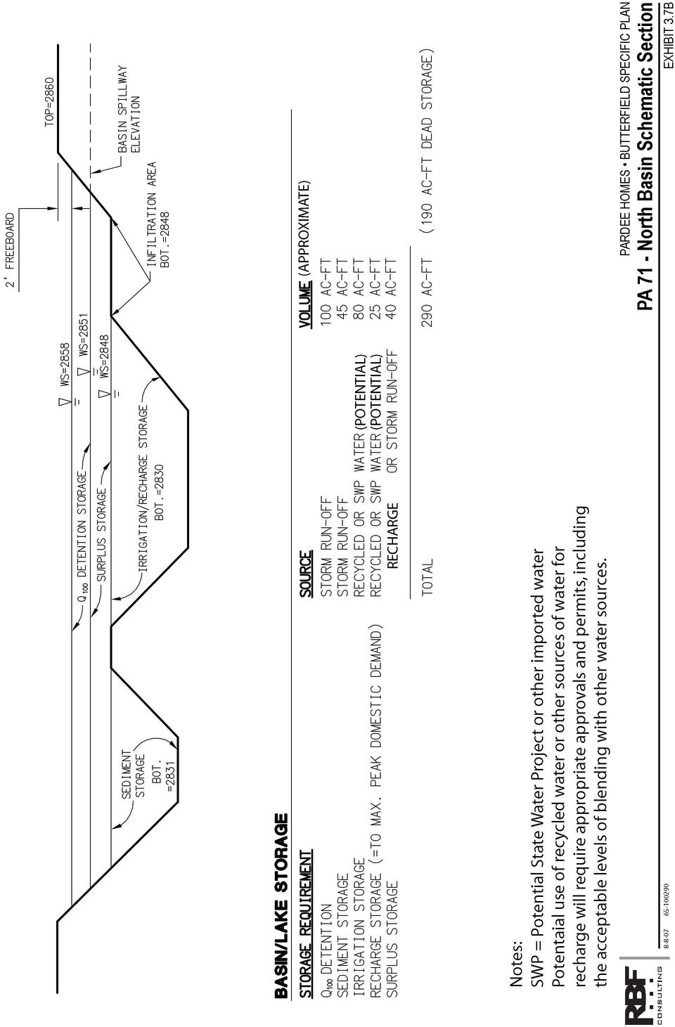
2 North Basin A realignment of Smith Creek is anticipated by this drainage plan. The project drainage to Smith Creek will drain to the proposed realigned creek in the golf course. A large detention basin is proposed within Planning Area 71 at the north end of the Specific Plan area where Smith Creek enters the site. This basin will be designed to detain upstream drainage flows to the extent that drainage flows leaving the project area at the south end (via the existing culvert under Wilson Street), including in the developed condition, will be equal to or less than existing conditions. The north basin is planned to have the main functions of detaining flows from expected 100 year storm events flowing in from Smith Creek and release this storm water in an acceptable controlled manner; and to detain sediment from off-site upstream flows of Smith Creek. Additionally the City could potentially elect to use the basin for storing State Water Project (SWP) water for use in groundwater recharge on the project site, if the City was to choose to acquire such water for this purpose via a pipeline extension connecting the existing SWP pipeline with PA 71 in the Specific Plan area. See Section 3.5.3, Groundwater Recharge Plan Description, in this Specific Plan for a further description of this. The City could also potentially elect to store recycled water (generated either at the City of Banning s main wastewater treatment plant or at onsite satellite wastewater treatment plant) that could be blended with other sources of water in the basin and which could be piped and pumped throughout Butterfield Specific Plan area for irrigation of the golf course and the common landscaped areas of the project, as well as potentially for groundwater recharge if pursued and approved. See Section 3.5.2, Recycled Water Service Plan Description, as well as Section of this Specific Plan for a further description of this. See Exhibit 3.7B, PA 71 North Basin Schematic Section for an indication of approximate potential water storage volumes proposed in the basin for these purposes. Portions of area surrounding the basin will be suitable for planting native vegetation to create potential native habitat restoration areas. The basin may also be used to establish a recreational area, suitable for potential fishing, operation of non-motorized boats, picnicking and hiking. The north basin in Planning Area 71 will contain three subparts, a desilting basin to desilt upstream flows, a weir which helps to contain any accumulated materials, and a connected larger part of the basin which receives stormwater overflow from the desilting basin. A much smaller (3+ acres) proposed lake basin in the north central part of the golf course will provide additional limited drainage detention. Please refer to Exhibit 3.7A, Master Drainage Plan, for the overall project drainage concept and location of the PA 71 basin. Please refer to Exhibit 3.7B, PA 71 North Basin Schematic Section for an indication of approximate potential water storage volumes proposed in the basin. A concept landscape plan of the Planning Area 71 north basin can be seen in Section 4.0, Development Design Guidelines, of this Specific Plan as Exhibit 4.8J, PA 71 North Basin Landscape Concept Plan. Golf Course Open Space Drainage System The main backbone drainage facility for this Specific Plan consists of a large open channel section that will run from north to south for the most part in the golf course open space realigned as Smith Creek. During significant storm events, the channel will spread over its top of channel and spread onto the fairways and open space. By spreading the flows, the wetted perimeter is increased resulting in slower velocities. Page 3-50

3 Where necessary, some limited detention along Smith Creek may be designed to further control release of onsite stormwater. The proposed main channel will be lined in areas with turf reinforcing mat (TRM), which will be covered in soil and vegetated. The result is a natural, vegetated channel. Where the velocities are significant, drop structures will be utilized to dissipate energy and slow down the flows. These drop structures, constructed to fit within restored natural conditions to the greatest extent possible, will protect the channel from erosion. Culverts will be placed at the proposed street crossings. Drainage from development areas within the Specific Plan will flow in streets and into storm drains to be taken to either the Smith Creek drainage in the golf course open space or the Pershing Channel. Before low flow drainage or first flush storm runoff enters either Smith Creek or Pershing Channel, the flows will pass through water quality treatment facilities. These water quality treatment facilities will likely consist of vegetated detention basins or vegetated flow through swales, which will be located in the golf course open space areas or other open space areas, or may be in the residential areas. Drainage flows exiting the golf course open space will flow under the South Loop Road and into the south channel, located within Planning Area 19. This is proposed as an earthen channel, vegetated with native plant materials. All flows from the south channel will pass offsite to the south, through an existing culvert under Wilson Street. Please refer to Exhibit 3.7A, Master Drainage Plan. Refer to Exhibit 3.7C, Conceptual Golf Course Drainage Plan, for a more detailed depiction of this concept, including potential water quality feature locations and groundwater recharge areas (discussed in Section 3.5). A conceptual landscape plan of the Planning Area 19 south channel can be seen in Section 4.0, Development Design Guidelines, of this Specific Plan as Exhibit 4.8I, PA 19 South Channel Landscape Concept Plan. The proposed drainage facilities were designed to replace the systems identified in the County and City Master Plan of Drainage. The proposed drainage system provides the same function as those facilities previously master planned, and could potentially reduce the master planned flow rates at the project boundaries Drainage Plan Development Standards In order to ensure orderly development, the Drainage Plan described above shall be subject to general principles and standards as follows: 1. The Project shall be subject to the requirements indicated in the Riverside County Flood Control District and Water Conservation District Hydrology Manual and the City of Banning flood control standards, including the following provisions: a) All building pads shall be free from flood hazard for the 100-year frequency storm by elevating finished floor elevations one foot above the 100-year level of flood protection; and b) Depths of flow in the streets shall not exceed top of curb elevations for the 10-year frequency. Page 3-51

4 2. The potential for the conveyance of debris from off-site watersheds shall be taken into account into the design of the proposed facilities. 3. Prior to site development, the proposed interior road infrastructure and grading design shall be coordinated to ensure that there is not any major diversion of drainage areas between watersheds. 4. The design of all interior storm drain conveyances and local storm drain facilities shall be in accordance with the criteria RCFCWCD guidelines. Flood flows used in the design of waterways, channels, and closed conduits shall have minimum average recurrence intervals as follows: a) Storm drain systems shall be designed and based on a minimum 10-year frequency. b) For sump conditions, a 25-year frequency shall be applied, and a connected system shall be designed to completely convey 100-year runoff, with a secondary outlet to assure the water surface is one foot below the proposed pad elevations. 5. On-site public drainage facilities located outside of the road right-of-way shall be contained in drainage easements. 6. Streets shall be oriented to maximum potential conveyance of regional flooding during significant storms to expedite the flow through the development. 7. The Specific Plan shall be phased such that 100-year flood protection is ensured in all areas of the development. Interim improvements shall be provided as phasing of the development progresses. 8. New development shall be required to prepare a master flood utility plan for storm drainage conveyance. 9. All projects shall be required to retain any increased drainage onsite until such time as a viable drainage plan is implemented. Development proposed following implementation of such a drainage plan shall be implemented in accordance with the approved drainage master plan. 10. Best Management Practices (BMPs) shall be implemented to enhance pollutant removal during storms and to improve the quality of stormwater runoff. 11. Prior to development of upstream areas, the potential for the conveyance of debris by the offsite watershed shall be accounted for in design of onsite drainage facilities in order to avoid abrasive erosion in certain drainage facilities and maintenance problems for facilities located within the floodplain. 12. Inspection and maintenance of public storm drain systems shall be performed by City of Banning. 13. Construction of each phase shall include an assessment of the size and flow patterns of the adjacent undeveloped areas on the Specific Plan area. Page 3-52
 Storm drain systems shall be designed and based on a minimum")
5 14. Each phase shall prepare an erosion control plan that provides the developed phases with the required flood protection. Flood protection shall be determined by the size of the undeveloped areas and the flow patterns. 15. Temporary basins shall be constructed to meet detention requirements and earthen channels/berms shall be used to divert and convey flows during construction phases. Page 3-53

6 This page was intentionally left blank Page 3-54
7 LEGEND Smith Creek Flow Direction Drainage Area Boundary Drainage Flow Direction Storm Drain Flow Direction Drainage Water Quality Treatment Facilities (BMP's) Potential Groundwater Recharge Infiltration Areas PARDEE HOMES BUTTERFIELD SPECIFIC PLAN Master Drainage Plan EXHIBIT 3.7A

8 This page was intentionally left blank Page 3-56

9
10 This page was intentionally left blank Page 3-58

11 LEGEND PARDEE HOMES BUTTERFIELD SPECIFIC PLAN Conceptual Golf Course Drainage Plan EXHIBIT 3.7C

12 This page was intentionally left blank Page 3-60

CLACKAMAS COUNTY ZONING AND DEVELOPMENT ORDINANCE
 1008 STORM DRAINAGE (3/24/05) 1008.01 PURPOSE To minimize the amount of stormwater runoff resulting from development utilizing nonstructural controls where possible, maintain and improve water quality,
Land Disturbance, Erosion Control and Stormwater Management Checklist. Walworth County Land Conservation Department
 Land Disturbance, Erosion Control and Stormwater Management Checklist Walworth County Land Conservation Department The following checklist is designed to assist the applicant in complying with the Walworth
5.14 Floodplains and Drainage/Hydrology
 I-70 East Final EIS 5.14 Floodplains and Drainage/Hydrology 5.14 Floodplains and Drainage/Hydrology This section discusses floodplain and drainage/hydrology resources and explains why they are important
DESCRIPTION OF STORMWATER STRUCTURAL CONTROLS IN MS4 PERMITS
 DESCRIPTION OF STORMWATER STRUCTURAL CONTROLS IN MS4 PERMITS Phase I MS4 permits require continuous updating of the stormwater system inventory owned and operated by the MS4. They also include inspection
A. Describe the existing drainage patterns on-site as shown on Map I, including any potential flooding and erosion problems.
 19. STORMWATER MANAGEMENT A. Describe the existing drainage patterns on-site as shown on Map I, including any potential flooding and erosion problems. The majority of the approximately ±500 acre Property
Sample DEQ Plan Submitter s Checklist for Stormwater Management Plans
 APPENDIX IV Version: February 2, 2015 Sample DEQ Plan Submitter s Checklist for Stormwater Management Plans Please fill in all blanks and please reference the plan sheets/pages where the information may
URBAN DRAINAGE CRITERIA
 URBAN DRAINAGE CRITERIA I. Introduction This division contains guidelines for drainage system design and establishes a policy for recognized and established engineering design of storm drain facilities
Outlet stabilization structure
 Overview of Sedimentation and Erosion Control Practices Practice no. 6.41 Outlet stabilization structure Erosion at the outlet of channels, culverts, and other structures is common, and can cause structural
Interlocking Concrete Pavement Institute (ICPI) Model Stormwater Ordinance for Permeable Interlocking Concrete Pavements August 2010
 Model Stormwater Ordinance for Permeable Interlocking Concrete Pavements August 2010") Interlocking Concrete Pavement Institute (ICPI) Model Stormwater Ordinance for Permeable Interlocking Concrete Pavements August 2010 Background What are permeable interlocking concrete pavements (PICP)?
Interlocking Concrete Pavement Institute (ICPI) Model Stormwater Ordinance for Permeable Interlocking Concrete Pavements August 2010 Background What are permeable interlocking concrete pavements (PICP)?
DOÑA ANA COUNTY DESIGN STORM CRITERIA GUIDELINES FOR COMMERCIAL AND RESIDENTIAL SITES. Run-off Analysis Methods
 DOÑA ANA COUNTY DESIGN STORM CRITERIA GUIDELINES FOR COMMERCIAL AND RESIDENTIAL SITES Run-off Analysis Methods This document sets forth the minimum design, technical criteria and specifications for the
STORMWATER MANAGEMENT CHECKLIST
 STORMWATER MANAGEMENT CHECKLIST *This checklist must be completed and part of the Land Disturbing Permit submittal for review if the acreage disturbed is one (1) acre or more: I. SUPPORTING DATA Narrative
5. Environmental Analysis
 5.11 The potential for adverse impacts on utilities and service systems was evaluated based on information concerning current service levels and the ability of the service providers to accommodate the
Town of Elkton & Cecil Soil Conservation District Checklist for Joint Agency Review Stormwater Management / Erosion and Sediment Control
 Town of Elkton & Cecil Soil Conservation District Checklist for Joint Agency Review Stormwater Management / Erosion and Sediment Control Project Name: Tax Map Parcel: Acreage: Plat: ADC Map & Grid Engineering
Chapter 3 CULVERTS. Description. Importance to Maintenance & Water Quality. Culvert Profile
 Chapter 3 CULVERTS Description A culvert is a closed conduit used to convey water from one area to another, usually from one side of a road to the other side. Importance to Maintenance & Water Quality
Greater Los Angeles County Region
 Attachment 6 Greater Los Angeles County Region IRWM Implementation Grant Proposal Monitoring, Assessment, and Attachment 6 consists of the following items: Monitoring, Assessment, and. The purpose of this
Index. protection. excavated drop inlet protection (Temporary) 6.50.1 6.51.1. Block and gravel inlet Protection (Temporary) 6.52.1
 6.50.1 6.51.1. Block and gravel inlet Protection (Temporary) 6.52.1") 6 Index inlet protection excavated drop inlet protection (Temporary) 6.50.1 HARDWARE CLOTH AND GRAVEL INLET PROTECTION Block and gravel inlet Protection (Temporary) sod drop inlet protection ROCK DOUGHNUT
6 Index inlet protection excavated drop inlet protection (Temporary) 6.50.1 HARDWARE CLOTH AND GRAVEL INLET PROTECTION Block and gravel inlet Protection (Temporary) sod drop inlet protection ROCK DOUGHNUT
CITY UTILITIES DESIGN STANDARDS MANUAL
 CITY UTILITIES DESIGN STANDARDS MANUAL Book 2 (SW) SW9 June 2015 SW9.01 Purpose This Chapter provides information for the design of open channels for the conveyance of stormwater in the City of Fort Wayne.
A Developer s Guide: Watershed-Wise Development
 A Developer s Guide: Watershed-Wise Development Environmental Protection What is a watershed? It does not matter how far away you build from a creek, lake, or the ocean, you are in a watershed. Another
Homeowner s Guide to Drainage
 Homeowner s Guide to Drainage a scottsdale homeowner s guide to drainage produced by the city of scottsdale s stormwater management division Transportation Department TABLE OF CONTENTS Introduction 2 Drainage
San Diego Integrated Regional Water Management Implementation Grant Proposal Economic Analysis Flood Damage Reduction Costs and Benefits
 Attachment 9 San Diego Integrated Regional Water Management Economic Analysis Flood Damage Reduction Costs and Benefits Attachment 9 consists of the following items: Flood Damage Reduction Costs and Benefits.
Minimizes sediment and debris from entering storm drains that lead to waterways and watercourses.
 4.5-p DRAIN INLET PROTECTION Alternative Names: DI protection, Drop Inlet Protection DESCRIPTION Storm drain inlet (DI) protection slows and ponds stormwater, and filters sediment and debris before it
Retention/Irrigation. Design Considerations. Soil for Infiltration Area Required Slope Environmental Side-effects
 Description Retention/irrigation refers to the capture of stormwater runoff in a holding pond and subsequent use of the captured volume for irrigation of landscape of natural pervious areas. This technology
Low Impact Development Checklist
 New Jersey Stormwater Best Management Practices Manual February 2004 A P P E N D I X A Low Impact Development Checklist A checklist for identifying nonstructural stormwater management strategies incorporated
CHAPTER 7 STORM WATER DESIGN
 CITY OF BOULDER DESIGN AND CONSTRUCTION STANDARDS CHAPTER 7 STORM WATER DESIGN TABLE OF CONTENTS Section Page 7.01 GENERAL...4 (A) INTENT... 4 (B) STORM WATER AND GREENWAYS MASTER PLANS... 4 (C) REFERENCE
Construction Site Inspection Checklist for OHC000004 By making use of some simple Best Management Practices (BMPs) a construction site operator can
 a construction site operator can") Construction Site Inspection Checklist for OHC000004 By making use of some simple Best Management Practices (BMPs) a construction site operator can do his or her share to protect Ohio's water resources
Construction Site Inspection Checklist for OHC000004 By making use of some simple Best Management Practices (BMPs) a construction site operator can do his or her share to protect Ohio's water resources
Rhode Island NRCS received approximately $2.4 million in ARRA funds to implement four floodplain easement projects.
 American Recovery and Reinvestment Act (ARRA) Emergency Watershed Protection Program Floodplain Easements Rhode Island Natural Resources Conservation Service Rhode Island NRCS received approximately $2.4
SUSTAINABLE URBAN DRAINAGE SYSTEMS
 overflow can lead into a permeable conveyance system to increase further the benefit and reduce the need for pipe systems. Pollutant removal rates have been shown to be high, with some pollutants being
PRIVATE TREATMENT CONTROL BMP OPERATION AND MAINTENANCE VERIFICATION FORM BIORETENTION FACILITIES, VEGETATED SWALES & HIGHER RATE BIOFILTERS
 BIORETENTION FACILITIES, VEGETATED SWALES & HIGHER RATE BIOFILTERS Check here for Address or phone number change the fiscal year (July 1 June 30), and date(s) maintenance was performed. Under Inspection,
STORMWATER POLLUTION PREVENTION PLAN TEMPLATE. 1.0 SITE DESCRIPTION 1.1 Project Name and Location Date
 STORMWATER POLLUTION PREVENTION PLAN TEMPLATE Disclaimer: This template was developed for guidance purposes only in an effort to assist Construction Storm Water permit applicants in meeting state and local
Mission Creek Flood Control & Restoration Project. City of Fremont, Alameda County
 Mission Creek Flood Control & Restoration Project City of Fremont, Alameda County Agenda Background Why are proposed improvements necessary? Proposed project components Challenges Construction schedule/phasing
10/4/2012. 40 slide sample of Presentation. Key Principles to Current Stormwater Management
 40 slide sample of Presentation Please contact [email protected] if you would like the complete presentation Key Principles to Current Stormwater Management Distributed Control Measures Integrated
Table 4.9 Storm Drain Inlet Protetion Applicable for
 BMP C220: Storm Drain Inlet Protection Purpose To prevent coarse sediment from entering drainage systems prior to permanent stabilization of the disturbed area. Conditions of Use Type of Inlet Protection
Harris County Flood Control District. Policy, Criteria, and Procedure Manual
 Harris County Flood Control District Policy, Criteria, and Procedure Manual For Approval and Acceptance of Infrastructure General Review October 10, 2003 Draft Please Provide Written Comments to the HCFCD
SITE-SPECIFIC BEST MANAGEMENT PRACTICES (BMP) PLAN REVIEW CHECKLIST
 PLAN REVIEW CHECKLIST") This checklist may be used by applicants for encroachment permits, and contractors in development of Site- Specific BMP Plans for projects. plan reviewers will use this checklist to review the Site-Specific
This checklist may be used by applicants for encroachment permits, and contractors in development of Site- Specific BMP Plans for projects. plan reviewers will use this checklist to review the Site-Specific
DRAINAGE :: DRAINAGE CONCERN FREQUENTLY ASKED QUESTIONS
 DRAINAGE :: DRAINAGE CONCERN FREQUENTLY ASKED QUESTIONS The City of DeSoto s Department of Development Services is the point of contact for storm drainage related issues. The following are some frequently
Riprap-lined Swale (RS)
") Riprap-lined Swale (RS) Practice Description A riprap-lined swale is a natural or constructed channel with an erosion-resistant rock lining designed to carry concentrated runoff to a stable outlet. This
Riprap-lined Swale (RS) Practice Description A riprap-lined swale is a natural or constructed channel with an erosion-resistant rock lining designed to carry concentrated runoff to a stable outlet. This
1.7.0 Floodplain Modification Criteria
 1.7.0 Floodplain Modification Criteria 1.7.1 Introduction These guidelines set out standards for evaluating and processing proposed modifications of the 100- year floodplain with the following objectives:
APPENDIX A: STORMWATER MANAGEMENT CHECKLIST
 APPENDIX A: STORMWATER MANAGEMENT CHECKLIST The first thing that applicants and designers must do before beginning a project is to make sure they are familiar with the 11 minimum standards listed in Manual
City of West Linn Public Works Design Standards 2010. Table of Contents
 City of West Linn Public Works Design Standards Table of Contents SECTION TWO STORM DRAIN REQUIREMENTS... 1 2.0000 STORM DRAINS... 1 2.0010 General Design Requirements...1 2.0011 Site Drainage Plans...2
STORM DRAINS CHAPTER 7
 CHAPTER 7 Chapter 7 - Storm Drains A storm drain is a drainage system that conveys water or stormwater, consisting of two or more pipes in a series connected by one or more structures. Storm drains collect
PLANNED UNIT DEVELOPMENT & SIDEWALK WAIVER REQUEST STAFF REPORT Date: November 7, 2013
 PLANNED UNIT DEVELOPMENT & SIDEWALK WAIVER REQUEST STAFF REPORT Date: November 7, 2013 NAME LOCATION Audubon Properties, LLC. 4700 & 4960 Dauphin Island Parkway West side of Dauphin Island Parkway, 580
4. Environmental Impacts Assessment and Remediation Targets
 4. Environmental Impacts Assessment and Remediation Targets 4.1 Environmental Impacts Significant additional development in the Alder Creek watershed is not anticipated at this time; however, there are
Exhibit A-7.III. Water Quality Management Plan (WQMP) Checklist
 Checklist") Exhibit A-7.III Water Quality Management Plan (WQMP) Checklist Water Quality Management Plan Checklist The purpose of this checklist is to provide a format for uniform, comprehensive, and welldocumented
Exhibit A-7.III Water Quality Management Plan (WQMP) Checklist Water Quality Management Plan Checklist The purpose of this checklist is to provide a format for uniform, comprehensive, and welldocumented
CHAPTER 17: STORM SEWER STANDARDS. 17.00 Introduction. 17.01 Administration. 17.02 Standards 17.1
 CHAPTER 17: STORM SEWER STANDARDS 17.00 Introduction 17.01 Administration 17.02 Standards 17.1 17.00 INTRODUCTION The purpose of this chapter is to provide guidance for the design and construction of storm
FLOOD PROTECTION BENEFITS
 IV. (340 points) Flood Protection Benefits A. Existing and potential urban development in the floodplain (50) 1. Describe the existing and potential urban development at the site and the nature of the
CITY OF HIGHLAND PARK, ILLINOIS Stormwater Management Fact Sheet
 CITY OF HIGHLAND PARK, ILLINOIS Stormwater Management Fact Sheet WHAT IS STORMWATER MANAGEMENT? Stormwater management is the method for channeling rainfall through pipes and sewers away from property to
Community Workshop 5. Overarching Goals for Machado Lake Ecosystem and Wilmington Drain Multi-Use Projects
 City of Los Angeles Department of Public Works Bureau of Engineering Machado Lake Ecosystem Rehabilitation Project & Wilmington Drain Multi-Use Project Community Workshop 5 February 24, 2009 In association
CHAPTER 62-624 MUNICIPAL SEPARATE STORM SEWER SYSTEMS
 CHAPTER 62-624 MUNICIPAL SEPARATE STORM SEWER SYSTEMS 62-624.100 Policy and Purpose. 62-624.200 Definitions. 62-624.300 General Provisions. 62-624.310 General Conditions, Individual Permits. 62-624.400
Architectural Processing and Inspections for Home Mortgage Insurance
 Page 1 of 5 [Text Only] Architectural Processing and Inspections for Home Mortgage Insurance Directive Number: 4145.1 SITE GRADING AND DRAINAGE GUIDELINES Construction complaints and structural defect
ECONOMIC ANALYSIS FLOOD DAMAGE REDUCTION. Lower Carmel River Floodplain Restoration and Enhancement Project
 ECONOMIC ANALYSIS FLOOD DAMAGE REDUCTION Lower Carmel River Floodplain Restoration and Enhancement Project I. Description of the Project and its Relationship to Other Projects in the Proposal The Lower
SITE-SPECIFIC BEST MANAGEMENT PRACTICES (SSBMP) PLAN/STORM WATER POLLUTION PREVENTION PLAN (SWPPP) REVIEW CHECKLIST
 PLAN/STORM WATER POLLUTION PREVENTION PLAN (SWPPP) REVIEW CHECKLIST") This checklist may be used by applicants for encroachment permits, and contractors in development of Site Specific Best Management Practice (SSBMP) Plans or Storm Water Pollution Prevention Plans (SWPPP)
This checklist may be used by applicants for encroachment permits, and contractors in development of Site Specific Best Management Practice (SSBMP) Plans or Storm Water Pollution Prevention Plans (SWPPP)
SUMP PUMP. City of Ann Arbor & C O L L E C T I O N S Y S T E M G L O S S A R Y
 Foundation A foundation is the bottom part of a building. It s the element that anchors the building to the ground and transmits the building s gravity load directly to the earth. Water damage weakens
Scheduling Maintenance for Infiltration Basins and Trenches
 Visual Inspection for Infiltration Practices Visual inspection is a rapid assessment procedure for qualitatively evaluating the functionality of a stormwater best management practice (BMP). Visual inspections
Lisgar District Basement Water Infiltration Investigation Answers to Residents Written Questions Received by Councillors Ward 10 Office
 Lisgar District Basement Water Infiltration Investigation Part A Answers to Technical Questions 1. There has been a tremendous amount of work done everywhere along the creek. If there was nothing wrong
ARTICLE II STORM DRAINAGE. (From Ordinance No. 1987-17; August 4, 1987; Sections III through VIII)
") ARTICLE II STORM DRAINAGE (From Ordinance No. 1987-17; August 4, 1987; Sections III through VIII) SECTION 2.1 Standard Provisions Standard Provisions All construction for storm drainage in the development
ARTICLE II STORM DRAINAGE (From Ordinance No. 1987-17; August 4, 1987; Sections III through VIII) SECTION 2.1 Standard Provisions Standard Provisions All construction for storm drainage in the development
CHAPTER II - STORM DRAINAGE
 CHAPTER II - STORM DRAINAGE 201 General 201.1 Use of Chapter II 201.2 Triggers for Drainage Report 201.3 Relationship to Chapter on Storm Water Quality 202 Design Guidelines 202.1 Hydrology 202.1.1 General
Appendix G: Model Stormwater Ordinance and Performance Standards
 Appendix G: Model Stormwater Ordinance and Performance Standards 1. Rein in the Runoff Model Low Impact Development Stormwater Ordinance for the Communities in the Spring Lake Watershed 2. Rein in the
DESIGN & TECHNICAL CRITERIA STORM DRAINAGE JEFFERSON COUNTY, COLORADO PLANNING & ZONING DIVISION
 DESIGN & TECHNICAL CRITERIA STORM DRAINAGE JEFFERSON COUNTY, COLORADO PLANNING & ZONING DIVISION Storm Drainage Design & Technical Criteria Acknowledgements Preparation of this document involved the efforts
GRAND COUNTY STORM DRAINAGE DESIGN AND TECHNICAL CRITERIA MANUAL. OFFICIALLY ADOPTED: August 1 st, 2006
 GRAND COUNTY STORM DRAINAGE DESIGN AND TECHNICAL CRITERIA MANUAL OFFICIALLY ADOPTED: August 1 st, 2006 TABLE OF CONTENTS CHAPTER TITLE PAGE 1 GENERAL PROVISIONS 1.1 Short Title.. 1 1.2 Jurisdiction 1 1.3
Computing Stormwater Runoff Rates and Volumes
 New Jersey Stormwater Best Management Practices Manual February 2004 C H A P T E R 5 Computing Stormwater Runoff Rates and Volumes This chapter discusses the fundamentals of computing stormwater runoff
Recommendations for future developments
 C Recommendations for future developments C.1 Reducing flood risk through site layout and design C.1.1 C.1.2 Flood risk should be considered at an early stage in deciding the layout and design of a site
Chapter 5.0. Stormwater Credits for Innovative Site Planning
 Chapter 5.0 Stormwater Credits for Innovative Site Planning Chapter 5. Stormwater Credits...Introduction 5.0 Stormwater Credits In Maryland, there are many programs at both the State and local level that
SECTION 5. Sediment Control Measures
 SECTION 5 Sediment Control Measures 60. STORM DRAIN INLET PROTECTION When Runoff from earth change activities will discharge to a catch basin or storm drain inlet. A newly constructed catch basin or storm
Henry Van Offelen Natural Resource Scientist MN Center for Environmental Advocacy [email protected]
 Henry Van Offelen Natural Resource Scientist MN Center for Environmental Advocacy [email protected] Wetland study slide Water Quality NRE goals in watershed plans Protect habitat that remains.
Planning and Zoning Commission Johnston, Iowa June 29, 2015
 ITEM NO. 15-19 Planning and Zoning Commission Johnston, Iowa June 29, 2015 SUBJECT: Consider recommending approval of the Final Plat for Crosshaven Plat 6 subdividing 28.28 acres into 47 single family
PART V BEST MANAGEMENT PRACTICES
 PART V BEST MANAGEMENT PRACTICES 5.0 Retention System Design and Performance Criteria 5.1 Description Retention system is defined as a storage area designed to store a defined quantity of runoff, allowing
CONSTRUCTION STORMWATER POLLUTION PREVENTION PLAN TEMPLATE
 CONSTRUCTION STORMWATER POLLUTION PREVENTION PLAN TEMPLATE The following template may be used as a general guide for development of a Stormwater Pollution Prevention Plan (SWPPP) for construction activities.
North San Jose Neighborhoods Planning Taskforce
 North San Jose Neighborhoods Planning Taskforce Key Topics Water Supply Flooding Related Topics Storm Water Storm Sewer Sanitary Sewer Water Conservation Treatment Plant Water Background Responsible Agencies
BMP #: Dry Wells / French Drains
 Structural BMP Criteria BMP #: Dry Wells / French Drains A Dry Well, or French Drain, is a variation on an Infiltration Trench that is designed to temporarily stores and infiltrate rooftop runoff. Key
8.1.3 General Design Guidelines. The following guidelines shall be used when designing inlets along a street section:
 . Introduction Presented in this chapter are the criteria and methodology for design and evaluation of storm sewer inlets located in Town of Castle Rock. The review of all planning submittals will be based
Vehicle Tracking Control (VTC)
") Vehicle Tracking Control (VTC) SM-4 Description Vehicle tracking controls provide stabilized construction site access where vehicles exit the site onto paved public roads. An effective vehicle tracking
Vehicle Tracking Control (VTC) SM-4 Description Vehicle tracking controls provide stabilized construction site access where vehicles exit the site onto paved public roads. An effective vehicle tracking
Foothill Municipal Water District Recycled Water Project
 Foothill Municipal Water District Recycled Water Project Update to Incorporate a Watershed Approach Introduction This paper will describe the Foothill Municipal Water District (FMWD) Recycled Water Project,
SITE DEVELOPMENT PLAN CHECKLIST. Project Name: Site Plan No.:
 SITE DEVELOPMENT PLAN CHECKLIST 5/12/05 Rev.3/14/06 Project Name: Site Plan No.: REVIEW CRITERIA Plans: A site development plan (signed and sealed) shall be on a 24 x 36 sheet at a scale that is no smaller
Pervious Pavers. By: Rich Lahren. Hebron Brick & Block Supply
 Pervious Pavers By: Rich Lahren Hebron Brick & Block Supply Stormwater Management and Control Issues Past emphasis was on flood control Today s emphasis is also on pollution More impermeable areas are
Stormwater Ponds. c ıty of a bı le ne st or m wat e r utı lıty dıv ısı on
 CLEAN WATER FACT SHEET Stormwater Ponds c ıty of a bı le ne st or m wat e r utı lıty dıv ısı on Rapid growth in the City of Abil ene and consequent development, as well as construction of culverts, drains,
Travel Time. Computation of travel time and time of concentration. Factors affecting time of concentration. Surface roughness
 3 Chapter 3 of Concentration and Travel Time Time of Concentration and Travel Time Travel time ( T t ) is the time it takes water to travel from one location to another in a watershed. T t is a component
SECTION 4.11 HYDROLOGY AND WATER QUALITY
 SECTION 4.11 HYDROLOGY AND WATER QUALITY This section describes federal, state and local regulations applicable to hydrology and water quality. It also describes the regional hydrologic setting, existing
CHAPTER 9 STORM DRAINAGE DESIGN AND STORMWATER QUALITY REGULATIONS
 June 27, 2011 Chapter 9 Storm Drainage Design and Stormwater Quality Regulations Table of Contents CHAPTER 9 STORM DRAINAGE DESIGN AND STORMWATER QUALITY REGULATIONS Table of Contents Chapter 9 Storm Drainage
Storm Water Runoff. Managing. A Self-Assessment Guide for Wisconsin Businesses. Storm water runoff is coming. This guide provides businesses
 Managing Storm Water Runoff A Self-Assessment Guide for Wisconsin Businesses Storm water runoff is coming under increasing scrutiny as both a source of pollutants to our lakes and streams, and as a cause
12-O-1761 A SUBSTITUTE ORDINANCE BY CITY UTILITIES COMMITTEE
 A SUBSTITUTE ORDINANCE BY CITY UTILITIES COMMITTEE 12-O-1761 AN ORDINANCE TO AMEND VARIOUS SECTIONS OF CHAPTER 74, ARTICLE X OF THE CITY OF ATLANTA CODE OF ORDINANCES FOR THE PURPOSE OF PROMOTING GREEN
Appendix A. Lists of Accomplishments and Project Costs. UMRWD 10 Year Plan Update. Appendix A UPPER MINNESOTA RIVER WATERSHED DISTRICT
 UPPER MINNESOTA RIVER WATERSHED DISTRICT Lists of Accomplishments and Project Costs 10 Year Plan Update UMRWD 10 Year Plan Update Page A 1 UMRWD LIST OF ACCOMPLISHMENTS Since its inception in 1967, the
Floodplain Development Land Use Review
 COMMUNITY DEVELOPMENT DEPARTMENT Planning Division P.O. Box 490 333 Broadalbin Street SW Albany, OR 97321 Phone 541-917-7550 Fax 541-791-0150 www.cityofalbany.net Floodplain Development Land Use Review
Stormwater/Wetland Pond Construction Inspection Checklist
 : Construction Inspection ChecklistsTools Stormwater/Wetland Pond Construction Inspection Checklist Project: Location: Site Status: Date: Time: Inspector: SATISFACTORY/ UNSATISFACTORY COMMENTS Pre-Construction/Materials
INFORMATION SHEET ORDER NO. R5-2011-XXXX TRIANGLE ROCK PRODUCTS, INC. FLORIN ROAD AGGREGATE PLANT SACRAMENTO COUNTY
 ORDER NO. R5-2011-XXXX INFORMATION SHEET Background Triangle Rock, Inc. (Discharger) submitted a Report of Waste Discharge (RWD) on 23 August 2010. The Discharger is expanding the mining operations at
CITY OF VAUGHAN SCHEDULE O LOT GRADING DESIGN FOR RESIDENTIAL DEVELOPMENT
 Page 1 CITY OF VAUGHAN SCHEDULE O LOT GRADING DESIGN FOR RESIDENTIAL DEVELOPMENT CIVIC CENTRE 2141 MAJOR MACKENZIE DRIVE MAPLE ONTARIO L6A 1T1 905-832-2281 Page 2 SECTION 1 - GENERAL OBJECTIVES To provide
Annual Standards and Specifications. Erosion and Sediment Control
 Annual Standards and Specifications for Erosion and Sediment Control January 2012 Version: September 15, 2009 INTRODUCTION Virginia Commonwealth University (VCU), Annual Standards and Specifications for
March 2008. Prepared by: Irvine Ranch Water District. 15600 Sand Canyon Avenue. Irvine, CA 92618. Contact: Natalie Likens (949) 453-5633
 453-5633") ADDENDUM TO THE MICHELSON WATER RECLAMATION PLANT PHASE 2 & 3 CAPACITY EXPANSION PROJECT FEBRUARY 2006 FINAL ENVIRONMENTAL IMPACT REPORT AND THE SAN JOAQUIN FRESHWATER MARSH ENHANCEMENT PLAN REVISED SEPTEMBER
ADDENDUM TO THE MICHELSON WATER RECLAMATION PLANT PHASE 2 & 3 CAPACITY EXPANSION PROJECT FEBRUARY 2006 FINAL ENVIRONMENTAL IMPACT REPORT AND THE SAN JOAQUIN FRESHWATER MARSH ENHANCEMENT PLAN REVISED SEPTEMBER
City of Shelbyville Site Inspection Checklist
 City of Shelbyville Site Inspection Checklist General Information Project Name: KYR10 Permit Number: Date: Project Location: Contractor: Conractor Representative: Inspector's Name: Title: Signature : Weather
ALAN BRUBAKER, P.E., P.S. SUMMIT COUNTY ENGINEER
 ALAN BRUBAKER, P.E., P.S. SUMMIT COUNTY ENGINEER STORMWATER DRAINAGE MANUAL Revised March 6, 2013 Revised February 7, 2013 Performance Requirements Part 1 Summit County Engineer Stormwater Drainage Manual
Adopted 9/23/98 CHATTAHOOCHEE CORRIDOR PLAN. The goals of the Chattahoochee Corridor Plan (hereinafter also referred to as the Plan ) are:
 are:") CHATTAHOOCHEE CORRIDOR PLAN Adopted 9/23/98 PART 1: GOALS. POLICY. COVERAGE. A. Goals The goals of the Chattahoochee Corridor Plan (hereinafter also referred to as the Plan ) are: 1. Preservation and protection
CHATTAHOOCHEE CORRIDOR PLAN Adopted 9/23/98 PART 1: GOALS. POLICY. COVERAGE. A. Goals The goals of the Chattahoochee Corridor Plan (hereinafter also referred to as the Plan ) are: 1. Preservation and protection
RIPRAP From Massachusetts Erosion and Sediment Control Guidelines for Urban and Suburban Areas http://www.mass.gov/dep/water/laws/policies.
 RIPRAP From Massachusetts Erosion and Sediment Control Guidelines for Urban and Suburban Areas http://www.mass.gov/dep/water/laws/policies.htm#storm Definition: A permanent, erosion-resistant ground cover