New Methods and Satellites: A Program Update on the NASS Cropland Data Layer Acreage Program. Rick Mueller Claire Boryan Bob Seffrin
|
|
|
- Barrie Stephens
- 9 years ago
- Views:
Transcription
1 New Methods and Satellites: A Program Update on the NASS Cropland Data Layer Acreage Program Rick Mueller Claire Boryan Bob Seffrin 01/12/2006

2 Agenda Acreage background Program scope/cooperators Program updates Results over Nebraska 05

3 Cropland Data Layer Acreage Estimates County and state level major crops Unbiased statistical estimator AL Cherokee AL Cullman AL De Kalb AL Etowah AL Jackson AL Lauderdale AL Lawrence AL Limestone AL Madison AL Marshall AL Morgan AL Talladega AL D10 Comb AL D20 Comb AL D30 Comb AL D40 Comb AL D50 Comb AL D60 Comb AL D10 Northe AL D20 Mount AL D30 Upper AL D40 Black AL D50 Coast AL D60 Wireg

4 Cropland Data Layer

5 Cropland Data Layer Acreage Estimates County and state level major crops Unbiased statistical estimator Based on Area Sampling Frame Uses June Agricultural Survey segments Ground truth training

6 Cropland Data Layer Acreage Estimates County and state level major crops Unbiased statistical estimator Based on Area Sampling Frame Uses June Agricultural Survey segments Ground truth training Landsat TM/ETM+ Launched 1984/1999

7 The Landsat Data Gap Landsat 7 ETM+ Landsat 5 TM Source: USGS, Landsat Project:

8 Cropland Data Layer Acreage Estimates County and state level major crops Unbiased statistical estimator Based on Area Sampling Frame Uses June Agricultural Survey segments Ground truth training Landsat TM/ETM+ Launched 1984/1999 Peditor Software Public domain Cluster/Classify/Regression/Mosaic

9 Project Players USDA/NASS Research Division Spatial Analysis Research Section Remote sensing analysts Software developers USDA/Foreign Ag Service Production Estimates & Crop Assessment Division PECAD Cooperative imagery provider

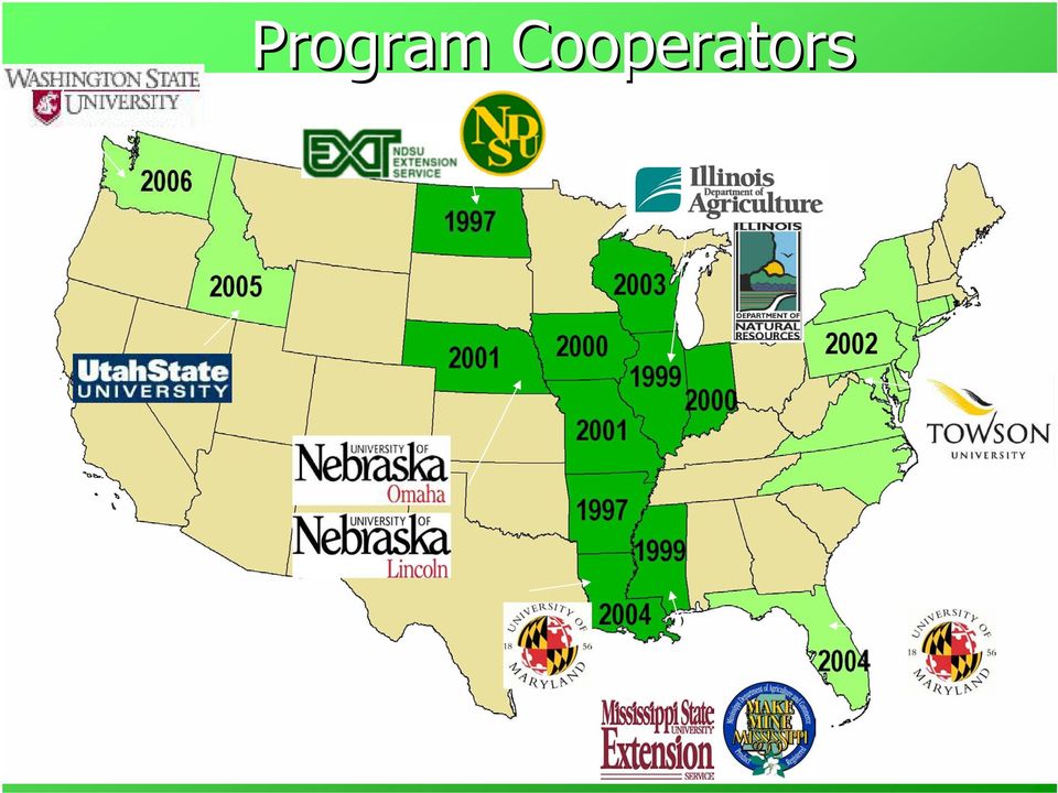
10 Program Cooperators
11 New Program Updates Indian Space Research Organization ResourceSat-1 AWiFS sensor

12 Indian Remote Sensing Satellite: ResourceSat-1 Advanced Wide Field Sensor (AWiFS) 370 km swath per quad 740 km combined 56 m resolution at nadir 70 m resolution at scene edges Launched 2003

13 Advanced Wide Field Sensor (AWiFS) Spectral Bands: B2: (Visible Green) B3: (Visible Red) B4: (Near Infrared B5: (Middle infrared) 5 day repeat cycle

14 Multi-date composite AWiFS image 4 image quadrants A,B,C,D AWiFS zoom bands: 3,4,2

15 New Program Updates Indian Space Research Organization ResourceSat-1 AWiFS sensor USDA/Farm Service Agency GeoSpatial Common Land Unit Administrative 578 data

16 USDA/Farm Service Agency Common Land Unit (CLU) GeoDataset National in scope (Enterprise GIS) Measures crop type & acreage Pare down data for training/testing Polygon based ground truth

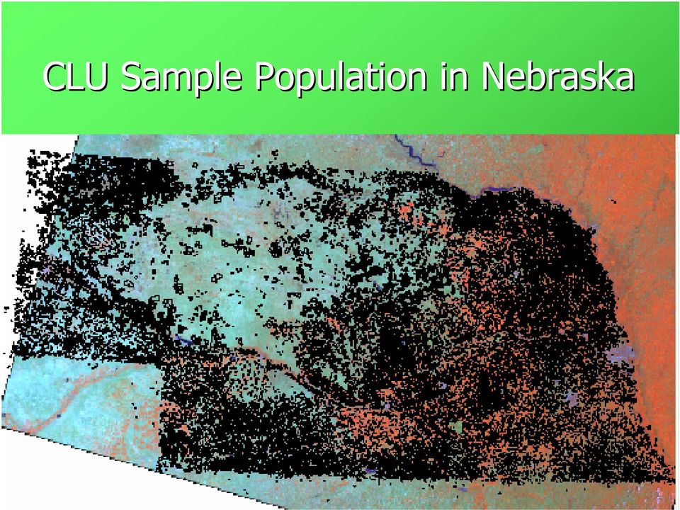
17 CLU Sample Population in Nebraska
18 Edit CLU s with ArcGIS Select fields with relationship Separate for training/testing Misses specialty/small acreage crops

19 New Program Updates Indian Space Research Organization ResourceSat-1 AWiFS sensor USDA/Farm Service Agency GeoSpatial Common Land Unit Administrative 578 data See5 CART software

20 See5 Methodology Summary See5 for derivation of decision tree classification rules Boosting & Smart Eliminate Imagine National Land Cover Dataset (NLCD) extension (USGS) See5 interface data prep Use of ancillary data Prior Cropland Data Layers to derive agricultural masks National Landcover Data Set (NLCD) Additional layers Canopy Impervious National Elevation Dataset (NED) Cloud masks Multiple dates of imagery used in application
 Cloud masks Multiple dates of imagery")
21 Ancillary Data sets Past Cropland Data Layers (multi-year) Agricultural mask created from past CDLs National Land Cover Data set 2001 Agricultural Mask Previous CDLs
22
23 Decision Tree Issues Pros Non parametric Continuous & thematic layers Large data volumes Data masking Repeatable/efficient Tolerant of outliers Literature Inexpensive Cons The trees created can be complex and difficult to interpret Somewhat a black box in operation Reliant on other software for data preparation and finishing
24 Acreage Program Results Nebraska 2005 TM vs. AWiFS
25
26 Kappa Statistics and Pixel Counts for Nebraska 2005 Classifier Accuracy
27 Regression Analysis from Sample Estimation Landsat TM Corn AWiFS Corn Slope of Acres/Pixels = Slope of Acres/Pixels = R 2 (11) =.927 R 2 (12) =.934 Slope(11) =.251 Slope(12) =.244 R 2 (11) =.834 R 2 (12) =.854 Slope(11) =.709 Slope(12) =.745
28 Nebraska 2005 State Level Estimates as % Over/Under Agricultural Statistics Board (ASB)
29 Nebraska 2005 State Level Estimates +/- 2% CVs (Coefficient of Variation) 20 Corn % Over/Under ASB Final Soybeans Wheat June Ag TM AWiFS Source of Estimate
30 Program Summary AWiFS TM outperforms Only marginally for cropland cover types State level assessments AWiFS has larger CV s AWiFS lower Kappa Useful for the NASS estimation program More frequent cloud-free coverage Very efficient to manage and process FSA Common Land Unit Adequate alternative to JAS for training/testing JAS segments necessary for estimation See5 Classification accuracy Handling of large datasets Repeatability Speed Need other commercial applications to process datasets
31
ArcGIS Agricultural Land Use Maps from the Mississippi Cropland Data Layer
 ArcGIS Agricultural Land Use Maps from the Mississippi Cropland Data Layer Fred L. Shore, Ph.D. Mississippi Department of Agriculture and Commerce Jackson, MS, USA [email protected] Rick Mueller
A Fresh Approach to Agricultural Statistics: Data Mining and Remote Sensing
 A Fresh Approach to Agricultural Statistics: Data Mining and Remote Sensing Abstract Darcy Miller, Jaki McCarthy, Audra Zakzeski National Agricultural Statistics Service 3251 Old Lee Highway, Fairfax,
Land Use/ Land Cover Mapping Initiative for Kansas and the Kansas River Watershed
 Land Use/ Land Cover Mapping Initiative for Kansas and the Kansas River Watershed Kansas Biological Survey Kansas Applied Remote Sensing Program April 2008 Previous Kansas LULC Projects Kansas LULC Map
U.S. Geological Survey Earth Resources Operation Systems (EROS) Data Center
 Data Center") U.S. Geological Survey Earth Resources Operation Systems (EROS) Data Center World Data Center for Remotely Sensed Land Data USGS EROS DATA CENTER Land Remote Sensing from Space: Acquisition to Applications
U.S. Geological Survey Earth Resources Operation Systems (EROS) Data Center World Data Center for Remotely Sensed Land Data USGS EROS DATA CENTER Land Remote Sensing from Space: Acquisition to Applications
OBJECT BASED IMAGE CLASSIFICATION AND WEB-MAPPING TECHNIQUES FOR FLOOD DAMAGE ASSESSMENT
 OBJECT BASED IMAGE CLASSIFICATION AND WEB-MAPPING TECHNIQUES FOR FLOOD DAMAGE ASSESSMENT Ejaz Hussain, KyoHyouk Kim, Jie Shan {ehussain, kim458, jshan}@ecn.purdue.edu Geomatics Engineering, School of Civil
Using Remote Sensing to Monitor Soil Carbon Sequestration
 Using Remote Sensing to Monitor Soil Carbon Sequestration E. Raymond Hunt, Jr. USDA-ARS Hydrology and Remote Sensing Beltsville Agricultural Research Center Beltsville, Maryland Introduction and Overview
APPLICATION OF MULTITEMPORAL LANDSAT DATA TO MAP AND MONITOR LAND COVER AND LAND USE CHANGE IN THE CHESAPEAKE BAY WATERSHED
 APPLICATION OF MULTITEMPORAL LANDSAT DATA TO MAP AND MONITOR LAND COVER AND LAND USE CHANGE IN THE CHESAPEAKE BAY WATERSHED S. J. GOETZ Woods Hole Research Center Woods Hole, Massachusetts 054-096 USA
Generation of Cloud-free Imagery Using Landsat-8
 Generation of Cloud-free Imagery Using Landsat-8 Byeonghee Kim 1, Youkyung Han 2, Yonghyun Kim 3, Yongil Kim 4 Department of Civil and Environmental Engineering, Seoul National University (SNU), Seoul,
Land Use/Land Cover Map of the Central Facility of ARM in the Southern Great Plains Site Using DOE s Multi-Spectral Thermal Imager Satellite Images
 Land Use/Land Cover Map of the Central Facility of ARM in the Southern Great Plains Site Using DOE s Multi-Spectral Thermal Imager Satellite Images S. E. Báez Cazull Pre-Service Teacher Program University
Using Remote Sensing Imagery to Evaluate Post-Wildfire Damage in Southern California
 Graham Emde GEOG 3230 Advanced Remote Sensing February 22, 2013 Lab #1 Using Remote Sensing Imagery to Evaluate Post-Wildfire Damage in Southern California Introduction Wildfires are a common disturbance
A KNOWLEDGE-BASED APPROACH FOR REDUCING CLOUD AND SHADOW ABSTRACT
 A KNOWLEDGE-BASED APPROACH FOR REDUCING CLOUD AND SHADOW Mingjun Song, Graduate Research Assistant Daniel L. Civco, Director Laboratory for Earth Resources Information Systems Department of Natural Resources
ANALYSIS OF FOREST CHANGE IN FIRE DAMAGE AREA USING SATELLITE IMAGES
 ANALYSIS OF FOREST CHANGE IN FIRE DAMAGE AREA USING SATELLITE IMAGES Joon Mook Kang, Professor Joon Kyu Park, Ph.D Min Gyu Kim, Ph.D._Candidate Dept of Civil Engineering, Chungnam National University 220
Supervised Classification workflow in ENVI 4.8 using WorldView-2 imagery
 Supervised Classification workflow in ENVI 4.8 using WorldView-2 imagery WorldView-2 is the first commercial high-resolution satellite to provide eight spectral sensors in the visible to near-infrared
A Web Service based U.S. Cropland Visualization, Dissemination and Querying System
 A Web Service based U.S. Cropland Visualization, Dissemination and Querying System Rick Mueller, Zhengwei Yang, and Dave Johnson USDA/National Agricultural Statistics Service Weiguo Han and Liping Di GMU/Center
Review for Introduction to Remote Sensing: Science Concepts and Technology
 Review for Introduction to Remote Sensing: Science Concepts and Technology Ann Johnson Associate Director [email protected] Funded by National Science Foundation Advanced Technological Education program [DUE
Spectral Response for DigitalGlobe Earth Imaging Instruments
 Spectral Response for DigitalGlobe Earth Imaging Instruments IKONOS The IKONOS satellite carries a high resolution panchromatic band covering most of the silicon response and four lower resolution spectral
SAMPLE MIDTERM QUESTIONS
 Geography 309 Sample MidTerm Questions Page 1 SAMPLE MIDTERM QUESTIONS Textbook Questions Chapter 1 Questions 4, 5, 6, Chapter 2 Questions 4, 7, 10 Chapter 4 Questions 8, 9 Chapter 10 Questions 1, 4, 7
Operational Space- Based Crop Mapping Protocols at AAFC A. Davidson, H. McNairn and T. Fisette.
 Operational Space- Based Crop Mapping Protocols at AAFC A. Davidson, H. McNairn and T. Fisette. Science & Technology Branch. Agriculture and Agri-Food Canada. 1. Introduction Space-Based Crop Mapping at
RESOLUTION MERGE OF 1:35.000 SCALE AERIAL PHOTOGRAPHS WITH LANDSAT 7 ETM IMAGERY
 RESOLUTION MERGE OF 1:35.000 SCALE AERIAL PHOTOGRAPHS WITH LANDSAT 7 ETM IMAGERY M. Erdogan, H.H. Maras, A. Yilmaz, Ö.T. Özerbil General Command of Mapping 06100 Dikimevi, Ankara, TURKEY - (mustafa.erdogan;
Remote Sensing and GIS Application In Change Detection Study In Urban Zone Using Multi Temporal Satellite
 Remote Sensing and GIS Application In Change Detection Study In Urban Zone Using Multi Temporal Satellite R.Manonmani, G.Mary Divya Suganya Institute of Remote Sensing, Anna University, Chennai 600 025
Cloud-based Geospatial Data services and analysis
 Cloud-based Geospatial Data services and analysis Xuezhi Wang Scientific Data Center Computer Network Information Center Chinese Academy of Sciences 2014-08-25 Outlines 1 Introduction of Geospatial Data
TerraColor White Paper
 TerraColor White Paper TerraColor is a simulated true color digital earth imagery product developed by Earthstar Geographics LLC. This product was built from imagery captured by the US Landsat 7 (ETM+)
Precision Farming Technology Systems and Federal Crop Insurance
 Risk Management Agency Precision Farming Technology Systems and Federal Crop Insurance This presentation highlights specific features of Risk Management Agency programs, policy and procedure and is not
WATER BODY EXTRACTION FROM MULTI SPECTRAL IMAGE BY SPECTRAL PATTERN ANALYSIS
 WATER BODY EXTRACTION FROM MULTI SPECTRAL IMAGE BY SPECTRAL PATTERN ANALYSIS Nguyen Dinh Duong Department of Environmental Information Study and Analysis, Institute of Geography, 18 Hoang Quoc Viet Rd.,
Document Control Sheet
 Document Control Sheet 1. Security Classification For Official Use only 2. Distribution NRSC / ISRO, Online Distribution Through Bhuvan Portal 3. Report / Document version (a) Issue no. 01 4. Report /
Resolutions of Remote Sensing
 Resolutions of Remote Sensing 1. Spatial (what area and how detailed) 2. Spectral (what colors bands) 3. Temporal (time of day/season/year) 4. Radiometric (color depth) Spatial Resolution describes how
Monitoring Global Crop Condition Indicators Using a Web-Based Visualization Tool
 Monitoring Global Crop Condition Indicators Using a Web-Based Visualization Tool Bob Tetrault, Regional Commodity Analyst, and Bob Baldwin, GIS Specialist, USDA, Foreign Agricultural Service, Washington,
Automatic land-cover map production of agricultural areas using supervised classification of SPOT4(Take5) and Landsat-8 image time series.
 and Landsat-8 image time series.") Automatic land-cover map production of agricultural areas using supervised classification of SPOT4(Take5) and Landsat-8 image time series. Jordi Inglada 2014/11/18 SPOT4/Take5 User Workshop 2014/11/18
Automatic land-cover map production of agricultural areas using supervised classification of SPOT4(Take5) and Landsat-8 image time series. Jordi Inglada 2014/11/18 SPOT4/Take5 User Workshop 2014/11/18
Improving global data on forest area & change Global Forest Remote Sensing Survey
 Improving global data on forest area & change Global Forest Remote Sensing Survey work by FAO and partners - Adam Gerrand, E. Lindquist, R. D Annunzio, M. Wilkie, FAO, - F. Achard et al. TREES team at
The Idiots Guide to GIS and Remote Sensing
 The Idiots Guide to GIS and Remote Sensing 1. Picking the right imagery 1 2. Accessing imagery 1 3. Processing steps 1 a. Geocorrection 2 b. Processing Landsat images layerstacking 4 4. Landcover classification
Land Cover Mapping of the Comoros Islands: Methods and Results. February 2014. ECDD, BCSF & Durrell Lead author: Katie Green
 Land Cover Mapping of the Comoros Islands: Methods and Results February 2014 ECDD, BCSF & Durrell Lead author: Katie Green About the ECDD project The ECDD project was run by Bristol Conservation & Science
APPLICATION OF GOOGLE EARTH FOR THE DEVELOPMENT OF BASE MAP IN THE CASE OF GISH ABBAY SEKELA, AMHARA STATE, ETHIOPIA
 APPLICATION OF GOOGLE EARTH FOR THE DEVELOPMENT OF BASE MAP IN THE CASE OF GISH ABBAY SEKELA, AMHARA STATE, ETHIOPIA Abineh Tilahun Department of Geography and environmental studies, Adigrat University,
SPOT Satellite Earth Observation System Presentation to the JACIE Civil Commercial Imagery Evaluation Workshop March 2007
 SPOT Satellite Earth Observation System Presentation to the JACIE Civil Commercial Imagery Evaluation Workshop March 2007 Topics Presented Quick summary of system characteristics Formosat-2 Satellite Archive
A GIS helps you answer questions and solve problems by looking at your data in a way that is quickly understood and easily shared.
 A Geographic Information System (GIS) integrates hardware, software, and data for capturing, managing, analyzing, and displaying all forms of geographically referenced information. GIS allows us to view,
Development of an Impervious-Surface Database for the Little Blackwater River Watershed, Dorchester County, Maryland
 Development of an Impervious-Surface Database for the Little Blackwater River Watershed, Dorchester County, Maryland By Lesley E. Milheim, John W. Jones, and Roger A. Barlow Open-File Report 2007 1308
Methods for Monitoring Forest and Land Cover Changes and Unchanged Areas from Long Time Series
 Methods for Monitoring Forest and Land Cover Changes and Unchanged Areas from Long Time Series Project using historical satellite data from SACCESS (Swedish National Satellite Data Archive) for developing
A remote sensing instrument collects information about an object or phenomenon within the
 Satellite Remote Sensing GE 4150- Natural Hazards Some slides taken from Ann Maclean: Introduction to Digital Image Processing Remote Sensing the art, science, and technology of obtaining reliable information
Effect of Alternative Splitting Rules on Image Processing Using Classification Tree Analysis
 Effect of Alternative Splitting Rules on Image Processing Using Classification Tree Analysis Michael Zambon, Rick Lawrence, Andrew Bunn, and Scott Powell Abstract Rule-based classification using classification
Advanced Image Management using the Mosaic Dataset
 Esri International User Conference San Diego, California Technical Workshops July 25, 2012 Advanced Image Management using the Mosaic Dataset Vinay Viswambharan, Mike Muller Agenda ArcGIS Image Management
Selecting the appropriate band combination for an RGB image using Landsat imagery
 Selecting the appropriate band combination for an RGB image using Landsat imagery Ned Horning Version: 1.0 Creation Date: 2004-01-01 Revision Date: 2004-01-01 License: This document is licensed under a
The USGS Landsat Big Data Challenge
 The USGS Landsat Big Data Challenge Brian Sauer Engineering and Development USGS EROS [email protected] U.S. Department of the Interior U.S. Geological Survey USGS EROS and Landsat 2 Data Utility and Exploitation
How To Map Land Cover In The Midatlantic Region
 ADVANCES IN LAND COVER CLASSIFICATION FOR APPLICATIONS RESEARCH: A CASE STUDY FROM THE MID-ATLANTIC RESAC Dmitry L. Varlyguin, Robb K. Wright, Scott J. Goetz, Stephen D. Prince Mid-Atlantic Regional Earth
Introduction to Imagery and Raster Data in ArcGIS
 Esri International User Conference San Diego, California Technical Workshops July 25, 2012 Introduction to Imagery and Raster Data in ArcGIS Simon Woo slides Cody Benkelman - demos Overview of Presentation
Some elements of photo. interpretation
 Some elements of photo Shape Size Pattern Color (tone, hue) Texture Shadows Site Association interpretation Olson, C. E., Jr. 1960. Elements of photographic interpretation common to several sensors. Photogrammetric
CLASSIFICATION OF AURANGABAD CITY USING HIGH RESOLUTION REMOTE SENSING DATA
 CLASSIFICATION OF AURANGABAD CITY USING HIGH RESOLUTION REMOTE SENSING DATA Kiran Bagade 1, Second Amol Vibhute 2, K.V. Kale 3 1 Student Department of Computer Science & IT, Dr. Babasaheb Ambedkar Marathwada
'Developments and benefits of hydrographic surveying using multispectral imagery in the coastal zone
 Abstract With the recent launch of enhanced high-resolution commercial satellites, available imagery has improved from four-bands to eight-band multispectral. Simultaneously developments in remote sensing
Remote Sensing Method in Implementing REDD+
 Remote Sensing Method in Implementing REDD+ FRIM-FFPRI Research on Development of Carbon Monitoring Methodology for REDD+ in Malaysia Remote Sensing Component Mohd Azahari Faidi, Hamdan Omar, Khali Aziz
GEOGRAPHIC INFORMATION SYSTEMS Lecture 20: Adding and Creating Data
 Adding Existing Data Into ArcGIS - there are many different ways to get data into ArcGIS GEOGRAPHIC INFORMATION SYSTEMS Lecture 20: Adding and Creating Data Add Data - normally we use the Add Data button
III THE CLASSIFICATION OF URBAN LAND COVER USING REMOTE SENSING
 The Dynamics of Global Urban Expansion 31 III THE CLASSIFICATION OF URBAN LAND COVER USING REMOTE SENSING 1. Overview and Rationale The systematic study of global urban expansion requires good data that
Earth Data Science in The Era of Big Data and Compute
 Earth Data Science in The Era of Big Data and Compute E. Lynn Usery U.S. Geological Survey [email protected] http://cegis.usgs.gov U.S. Department of the Interior U.S. Geological Survey Board on Earth Sciences
Monitoring Overview with a Focus on Land Use Sustainability Metrics
 Monitoring Overview with a Focus on Land Use Sustainability Metrics Canadian Roundtable for Sustainable Crops. Nov 26, 2014 Agriclimate, Geomatics, and Earth Observation Division (ACGEO). Presentation
Accuracy Assessment of Land Use Land Cover Classification using Google Earth
 American Journal of Environmental Protection 25; 4(4): 9-98 Published online July 2, 25 (http://www.sciencepublishinggroup.com/j/ajep) doi:.648/j.ajep.2544.4 ISSN: 228-568 (Print); ISSN: 228-5699 (Online)
RULE INHERITANCE IN OBJECT-BASED IMAGE CLASSIFICATION FOR URBAN LAND COVER MAPPING INTRODUCTION
 RULE INHERITANCE IN OBJECT-BASED IMAGE CLASSIFICATION FOR URBAN LAND COVER MAPPING Ejaz Hussain, Jie Shan {ehussain, jshan}@ecn.purdue.edu} Geomatics Engineering, School of Civil Engineering, Purdue University
UPPER COLUMBIA BASIN NETWORK VEGETATION CLASSIFICATION AND MAPPING PROGRAM
 UPPER COLUMBIA BASIN NETWORK VEGETATION CLASSIFICATION AND MAPPING PROGRAM The Upper Columbia Basin Network (UCBN) includes nine parks with significant natural resources in the states of Idaho, Montana,
Landsat Monitoring our Earth s Condition for over 40 years
 Landsat Monitoring our Earth s Condition for over 40 years Thomas Cecere Land Remote Sensing Program USGS ISPRS:Earth Observing Data and Tools for Health Studies Arlington, VA August 28, 2013 U.S. Department
MOTOR VEHICLE ACCIDENT MORTALITY
 Indicators of Health Status in MOTOR VEHICLE ACCIDENT MORTALITY Jointly produced to assist those seeking to improve health care in rural by The Office of Primary Care and Rural Health, Department of Public
Partitioning the Conterminous United States into Mapping Zones for Landsat TM Land Cover Mapping
 Partitioning the Conterminous United States into Mapping Zones for Landsat TM Land Cover Mapping Collin Homer Raytheon, EROS Data Center, Sioux Falls, South Dakota 605-594-2714 [email protected] Alisa Gallant
Michigan Tech Research Institute Wetland Mitigation Site Suitability Tool
 Michigan Tech Research Institute Wetland Mitigation Site Suitability Tool Michigan Tech Research Institute s (MTRI) Wetland Mitigation Site Suitability Tool (WMSST) integrates data layers for eight biophysical
Site-specific management at Bowles Farming Company. UC Davis Precision Ag Workshop 7/14/2010 Cannon Michael Bowles Farming Company, Inc.
 Site-specific management at Bowles Farming Company UC Davis Precision Ag Workshop 7/14/2010 Cannon Michael Bowles Farming Company, Inc. Bowles Farming Company, Inc. Family owned and operated 150+ years
APPLICATION OF TERRA/ASTER DATA ON AGRICULTURE LAND MAPPING. Genya SAITO*, Naoki ISHITSUKA*, Yoneharu MATANO**, and Masatane KATO***
 APPLICATION OF TERRA/ASTER DATA ON AGRICULTURE LAND MAPPING Genya SAITO*, Naoki ISHITSUKA*, Yoneharu MATANO**, and Masatane KATO*** *National Institute for Agro-Environmental Sciences 3-1-3 Kannondai Tsukuba
Data Processing Flow Chart
 Legend Start V1 V2 V3 Completed Version 2 Completion date Data Processing Flow Chart Data: Download a) AVHRR: 1981-1999 b) MODIS:2000-2010 c) SPOT : 1998-2002 No Progressing Started Did not start 03/12/12
EO based glacier monitoring
 EO based glacier monitoring THEMES 1. WGMS & GLIMS within GTN G: strategic set up 2. GlobGlacier & Glaciers_cci: EO based products 3. LDCM & Sentinel 2: future monitoring perspectives Frank Paul* Department
Nigerian Satellite Systems, and her Remote Sensing Data
 Nigerian Satellite Systems, and her Remote Sensing Data S. O. Mohammed, PhD (Director-General/Chief Executive) National Space Research & Development Agency (NASRDA) A Presentation at the 2010 International
Understanding Raster Data
 Introduction The following document is intended to provide a basic understanding of raster data. Raster data layers (commonly referred to as grids) are the essential data layers used in all tools developed
Multinomial Logistics Regression for Digital Image Classification
 Multinomial Logistics Regression for Digital Image Classification Dr. Moe Myint, Chief Scientist, Mapping and Natural Resources Information Integration (MNRII), Switzerland [email protected] KEY
Image Analysis CHAPTER 16 16.1 ANALYSIS PROCEDURES
 CHAPTER 16 Image Analysis 16.1 ANALYSIS PROCEDURES Studies for various disciplines require different technical approaches, but there is a generalized pattern for geology, soils, range, wetlands, archeology,
Cloud Detection for Sentinel 2. Curtis Woodcock, Zhe Zhu, Shixiong Wang and Chris Holden
 Cloud Detection for Sentinel 2 Curtis Woodcock, Zhe Zhu, Shixiong Wang and Chris Holden Background 3 primary spectral regions useful for cloud detection Optical Thermal Cirrus bands Legacy Landsats have
Monitoring of Arctic Conditions from a Virtual Constellation of Synthetic Aperture Radar Satellites
 DISTRIBUTION STATEMENT A. Approved for public release; distribution is unlimited. Monitoring of Arctic Conditions from a Virtual Constellation of Synthetic Aperture Radar Satellites Hans C. Graber RSMAS
Geospatial intelligence and data fusion techniques for sustainable development problems
 Geospatial intelligence and data fusion techniques for sustainable development problems Nataliia Kussul 1,2, Andrii Shelestov 1,2,4, Ruslan Basarab 1,4, Sergii Skakun 1, Olga Kussul 2 and Mykola Lavreniuk
SMEX04 Land Use Classification Data
 Notice to Data Users: The documentation for this data set was provided solely by the Principal Investigator(s) and was not further developed, thoroughly reviewed, or edited by NSIDC. Thus, support for
AERIAL PHOTOGRAPHS. For a map of this information, in paper or digital format, contact the Tompkins County Planning Department.
 AERIAL PHOTOGRAPHS What are Aerial Photographs? Aerial photographs are images of the land taken from an airplane and printed on 9 x9 photographic paper. Why are Aerial Photographs Important? Aerial photographs
Lake Monitoring in Wisconsin using Satellite Remote Sensing
 Lake Monitoring in Wisconsin using Satellite Remote Sensing D. Gurlin and S. Greb Wisconsin Department of Natural Resources 2015 Wisconsin Lakes Partnership Convention April 23 25, 2105 Holiday Inn Convention
Master Sampling Frame for Agriculture and Rural Statistics. Fred Vogel Gero Carletto The World Bank
 Master Sampling Frame for Agriculture and Rural Statistics Fred Vogel Gero Carletto The World Bank What are the strategic directions of the Global Strategy? Broadens Scope of Agricultural Statistics Adds
Adding Data from APFO s Public ArcGIS Server into ArcMap 10.x. The short instructions for accessing this service consist of stating that
 Adding Data from APFO s Public ArcGIS Server into ArcMap 10.x APFO provides the most current year of NAIP imagery, as well as satellite imagery for Hawaii, in a web service for public users. There are
2.3 Spatial Resolution, Pixel Size, and Scale
 Section 2.3 Spatial Resolution, Pixel Size, and Scale Page 39 2.3 Spatial Resolution, Pixel Size, and Scale For some remote sensing instruments, the distance between the target being imaged and the platform,
3D Model of the City Using LiDAR and Visualization of Flood in Three-Dimension
 3D Model of the City Using LiDAR and Visualization of Flood in Three-Dimension R.Queen Suraajini, Department of Civil Engineering, College of Engineering Guindy, Anna University, India, [email protected]
Preface. Ko Ko Lwin Division of Spatial Information Science University of Tsukuba 2008
 1 Preface Remote Sensing data is one of the primary data sources in GIS analysis. The objective of this material is to provide fundamentals of Remote Sensing technology and its applications in Geographical
VISUALIZATION OF A CROP SEASON THE INTEGRATION OF REMOTELY SENSED DATA AND SURVEY DATA
 VISUALIZATION OF A CROP SEASON THE INTEGRATION OF REMOTELY SENSED DATA AND SURVEY DATA Gail Wade GIS Analyst, Spatial Analysis Research Section George Hanuschak Chief, Geospatial Information Branch Research
Crop Drought Stress Monitoring by Remote Sensing (DROSMON) Overview. Werner Schneider
 Overview. Werner Schneider") Crop Drought Stress Monitoring by Remote Sensing (DROSMON) Overview Werner Schneider Institut of Surveying, Remote Sensing and Land Information Department of Landscape, Spatial and Infrastructure Sciences
Crop Drought Stress Monitoring by Remote Sensing (DROSMON) Overview Werner Schneider Institut of Surveying, Remote Sensing and Land Information Department of Landscape, Spatial and Infrastructure Sciences
Imagery. 1:50,000 Basemap Generation From Satellite. 1 Introduction. 2 Input Data
 1:50,000 Basemap Generation From Satellite Imagery Lisbeth Heuse, Product Engineer, Image Applications Dave Hawkins, Product Manager, Image Applications MacDonald Dettwiler, 3751 Shell Road, Richmond B.C.
SEMI-AUTOMATED CLOUD/SHADOW REMOVAL AND LAND COVER CHANGE DETECTION USING SATELLITE IMAGERY
 SEMI-AUTOMATED CLOUD/SHADOW REMOVAL AND LAND COVER CHANGE DETECTION USING SATELLITE IMAGERY A. K. Sah a, *, B. P. Sah a, K. Honji a, N. Kubo a, S. Senthil a a PASCO Corporation, 1-1-2 Higashiyama, Meguro-ku,
Mapping Solar Energy Potential Through LiDAR Feature Extraction
 Mapping Solar Energy Potential Through LiDAR Feature Extraction WOOLPERT WHITE PAPER By Brad Adams [email protected] DESIGN GEOSPATIAL INFRASTRUCTURE November 2012 Solar Energy Potential Is Largely
and satellite image download with the USGS GloVis portal
 Tutorial: NDVI calculation with SPRING GIS and satellite image download with the USGS GloVis portal Content overview: Downloading data from GloVis: p 2 Using SPRING GIS: p 11 This document is meant to
ENVI THE PREMIER SOFTWARE FOR EXTRACTING INFORMATION FROM GEOSPATIAL IMAGERY.
 ENVI THE PREMIER SOFTWARE FOR EXTRACTING INFORMATION FROM GEOSPATIAL IMAGERY. ENVI Imagery Becomes Knowledge ENVI software uses proven scientific methods and automated processes to help you turn geospatial
Remote Sensing and Land Use Classification: Supervised vs. Unsupervised Classification Glen Busch
 Remote Sensing and Land Use Classification: Supervised vs. Unsupervised Classification Glen Busch Introduction In this time of large-scale planning and land management on public lands, managers are increasingly
Nature Values Screening Using Object-Based Image Analysis of Very High Resolution Remote Sensing Data
 Nature Values Screening Using Object-Based Image Analysis of Very High Resolution Remote Sensing Data Aleksi Räsänen*, Anssi Lensu, Markku Kuitunen Environmental Science and Technology Dept. of Biological
Pipeline Routing using GIS and Remote Sensing Tobenna Opara Ocean Engineering Department University of Rhode Island [email protected].
 Pipeline Routing using GIS and Remote Sensing Tobenna Opara Ocean Engineering Department University of Rhode Island [email protected] Pipelines are utilized by the oil and gas industry to transport
Object-Oriented Approach of Information Extraction from High Resolution Satellite Imagery
 IOSR Journal of Computer Engineering (IOSR-JCE) e-issn: 2278-0661,p-ISSN: 2278-8727, Volume 17, Issue 3, Ver. IV (May Jun. 2015), PP 47-52 www.iosrjournals.org Object-Oriented Approach of Information Extraction