EO based glacier monitoring
|
|
|
- Morgan Walsh
- 10 years ago
- Views:
Transcription
1 EO based glacier monitoring THEMES 1. WGMS & GLIMS within GTN G: strategic set up 2. GlobGlacier & Glaciers_cci: EO based products 3. LDCM & Sentinel 2: future monitoring perspectives Frank Paul* Department of Geography, University of Zurich * with contributions from M. Zemp (WGMS) and A. Kääb (Oslo)

2 History of the international glacier monitoring Internationally coordinated glacier observation initiated in 1894 by the International Glacier Commission GTN G Steering Committee Combination of former ICSI services (PSFG, TTS/WGI) into the WGMS in 1986 Advisory Board Executive Board Since then WGMS continues to collect and publish standardised worldwide glacier data Glacier changes with time (glacier fluctuations) Spatial distribution of perennial surface ice (glacier inventories) Global Land Ice Measurements from Space World Glacier Monitoring Service US National Snow and Ice Data Center Today, the international glacier monitoring is coordinated by WGMS, NSIDC and GLIMS within the Global Terrestrial Network for Glaciers (GTN G)

3 GTN G: The structure behind it

4 GTN G: set up and goals In cooperation with NSIDC and GLIMS, the WGMS runs the Global Terrestrial Network for Glaciers (GTN G) as part of GTOS/GCOS for the UNFCCC. This network follows a multi level monitoring strategy, integrating in situ measurements, remote sensing and numerical modelling.

5 Observing strategy main goals of long term observations: process understanding model validation change detection impact assessments change detection: Haeberli et al. (2000) rate of change acceleration trends pre industrial variability change patterns integrated / tiered observing strategy Tier 1: multi component obs. system across environmental gradients Tier 2: process understanding and model calibration => extensive energy/mass balance, flow Tier 3: regional indicators => mass change (index stakes, photogrammetry, LIDAR) Tier 4: regional representativeness => cumulative length change of selected glaciers Tier 5: global coverage => inventories (remote sensing/geoinformatics)
 Tier 4: regional representativeness => cumulative length change of selected glaciers Tier 5: global coverage => inventories")
6 Gobal and regional glacier mass budgets WGMS (2008)

7 WGMS (2008) Global and regional front variations

8 Global glacier distribution (WGI)

9 WGMS data products

10 One stop portal on g.org FoG WGMS WGI WGMS / NSIDC GLIMS NSIDC glacierphoto NSDIC

11 ECVs & satellite contributions GCOS107 Radic & Hock Accuracy 3%, Resolution: 30 m, Precision: 0.01 km 2, Sensors: optical (Landsat) Raper & Braithwaite IPCC WGI vs. DCW
 Raper")
12 EO based products for glacier monitoring Area Glacier outlines (vector) from ratio image & manual editing Drainage divides & topographic parameters from DEM fusion Archived Landsat TM/ETM+ data with USGS L1T correction Elevation change Repeat altimetry in mostly Arctic regions for trend detection DEM differencing (geodetic mass balance) for entire glaciers freely available (SRTM, GDEM, USGS) and national DEMs Snow covered area threshold on TOA reflectance (requires topogr. correction) proxy for AAR and calibration of mass balance models Velocity fields InSAR, offset tracking (microw.), image matching (optical) averaging over weeks/years, requires good contrast glaciers in key regions, huge archives (PALSAR, ETM+ Pan)
 proxy for AAR and calibration of mass balance models Velocity fields InSAR, offset tracking (microw.")
13 AREA: Take a satellite image (Landsat)... scene from the USGS archive (South Georgia)

14 ... and convert it to outlines outlines (yellow) from Landsat ETM+ after editing

15 (this works also for tiny glaciers in the Alps) Mosaic of 10 Landsat TM scenes acquired in 2003

16 Change assessment: area and length
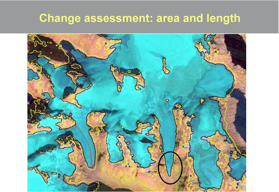
17 Change assessment: area and length most important: accurate orthorectification

18 SNOW: take a Landsat image & a DEM Topographically corrected TOA reflectance band 4 Snow covered area (white) after applying a threshold
 after applying a")
19 VOLUME: take DEMs from 2 points in time Zinal Randa Allalin Gorner Findelen Belvedere SRTM (2000) swisstopo (1985)
")
20 ... and determine overall volume change Silvretta Rhone Pl. Morte Aletsch Gries Basodino Forno Trient Gorner key method to assess the representativeness of the mass balance glaciers for the entire region

21 ELEVATION CHANGES: trend analysis from repeat altimetry (ICESat, RA 2)
22 VELOCITY: offset tracking from RADAR sensors optical image (Landsat ETM+)
23 VELOCITY: offset tracking from optical sensors
24 Area: precision of manual digitizing
25 Comparing Landsat with aerial photography automatic with Landsat TM 30 m rock fall manual digitizations
26 System context for glacier area
27 Snow reflectance & spectral bands
28 Swath width G Sentinel 2 Landsat ASTER
29 Processing levels & products
30 100 km tiles
31 Processing & distribution
32 Most critical issues (key concerns) Orthorectification L1B > L1C: SRTM or similar, SRTM improved Status of discussion and possible solutions L1C 100 km tiles Data granule size, seamless mosaicing tool (easy to use, batch possibility, collaborative ground segments) L1C UTM projection possibel solutions LDCM might be operational before, glovis already used, interest in Sentinel 2?
33 Othoprojection errors due to DTM errors Image plane H h Vertical DTM error h DTM Terrain R r R / H = r / h Map plane Horizontal distortion r
34 Getting global: EO Archives & DEMs The longest time series available is from Landsat 5 TM (for free at USGS)
35 PVASR: RR results (Landsat debris free) 90 m automatic with Landsat TM
36 PVASR: RR results (reference data) 90 m automatic with Landsat TM manual on Landsat TM
COMPARISON OF TM-DERIVED GLACIER AREAS WITH HIGHER RESOLUTION DATA SETS
 COMPARISON OF TM-DERIVED GLACIER AREAS WITH HIGHER RESOLUTION DATA SETS F. Paul, C. Huggel, A. Kääb, T. Kellenberger, M.Maisch Department of Geography, University of Zurich, Winterthurerstr. 190, 8057
5. GIS, Cartography and Visualization of Glacier Terrain
 5. GIS, Cartography and Visualization of Glacier Terrain 5.1. Garhwal Himalayan Glaciers 5.1.1. Introduction GIS is the computer system for capturing, storing, analyzing and visualization of spatial and
The USGS Landsat Big Data Challenge
 The USGS Landsat Big Data Challenge Brian Sauer Engineering and Development USGS EROS [email protected] U.S. Department of the Interior U.S. Geological Survey USGS EROS and Landsat 2 Data Utility and Exploitation
Cloud-based Geospatial Data services and analysis
 Cloud-based Geospatial Data services and analysis Xuezhi Wang Scientific Data Center Computer Network Information Center Chinese Academy of Sciences 2014-08-25 Outlines 1 Introduction of Geospatial Data
Glacier Mapping and Monitoring
 and Tobias Bolch TU Dresden, Universität Zürich D5P2a Optical and Thermal 20/06/2013 1 20/06/2013 1 Outline 1. s 2. Spectral Properties of s 3. of s a. Data Sources b. Automated mapping c. Postprocessing
High Resolution Information from Seven Years of ASTER Data
 High Resolution Information from Seven Years of ASTER Data Anna Colvin Michigan Technological University Department of Geological and Mining Engineering and Sciences Outline Part I ASTER mission Terra
White Paper. PlanetDEM 30. PlanetObserver 25/11/2014 - Update
 White Paper PlanetDEM 30 PlanetObserver 25/11/2014 - Update PlanetObserver France www.planetobserver.com [email protected] Tel. +33 4 73 44 19 00 1. Introduction PlanetObserver presents PlanetDEM
AUTOMATED DEM VALIDATION USING ICESAT GLAS DATA INTRODUCTION
 AUTOMATED DEM VALIDATION USING ICESAT GLAS DATA Mary Pagnutti Robert E. Ryan Innovative Imaging and Research Corp. Building 1103, Suite 140C Stennis Space Center, MS 39529 [email protected] [email protected]
Mapping Earth from Space Remote sensing and satellite images. Remote sensing developments from war
 Mapping Earth from Space Remote sensing and satellite images Geomatics includes all the following spatial technologies: a. Cartography "The art, science and technology of making maps" b. Geographic Information
Obtaining and Processing MODIS Data
 Obtaining and Processing MODIS Data MODIS is an extensive program using sensors on two satellites that each provide complete daily coverage of the earth. The data have a variety of resolutions; spectral,
Virtual constellations, time series, and cloud screening opportunities for Sentinel 2 and Landsat
 Virtual constellations, time series, and cloud screening opportunities for Sentinel 2 and Landsat Sentinel 2 for Science Workshop 20 22 May 2014 ESA ESRIN, Frascati (Rome), Italy 1 Part 1: Title: Towards
Annals of Glaciology 50(53) 2009 53
 2009 53") Annals of Glaciology 50(53) 2009 53 Challenges and recommendations in mapping of glacier parameters from space: results of the 2008 Global Land Ice Measurements from Space (GLIMS) workshop, Boulder, Colorado,
Annals of Glaciology 50(53) 2009 53 Challenges and recommendations in mapping of glacier parameters from space: results of the 2008 Global Land Ice Measurements from Space (GLIMS) workshop, Boulder, Colorado,
Earth Data Science in The Era of Big Data and Compute
 Earth Data Science in The Era of Big Data and Compute E. Lynn Usery U.S. Geological Survey [email protected] http://cegis.usgs.gov U.S. Department of the Interior U.S. Geological Survey Board on Earth Sciences
Landsat Monitoring our Earth s Condition for over 40 years
 Landsat Monitoring our Earth s Condition for over 40 years Thomas Cecere Land Remote Sensing Program USGS ISPRS:Earth Observing Data and Tools for Health Studies Arlington, VA August 28, 2013 U.S. Department
Methods for Monitoring Forest and Land Cover Changes and Unchanged Areas from Long Time Series
 Methods for Monitoring Forest and Land Cover Changes and Unchanged Areas from Long Time Series Project using historical satellite data from SACCESS (Swedish National Satellite Data Archive) for developing
How To Make An Orthophoto
 ISSUE 2 SEPTEMBER 2014 TSA Endorsed by: CLIENT GUIDE TO DIGITAL ORTHO- PHOTOGRAPHY The Survey Association s Client Guides are primarily aimed at other professionals such as engineers, architects, planners
TerraSAR X and TanDEM X satellite missions update & other activities Dana Floricioiu German Aerospace Center (DLR), Remote Sensing Technology
, Remote Sensing Technology") TerraSAR X and TanDEM X satellite missions update & other activities Dana Floricioiu German Aerospace Center (DLR), Remote Sensing Technology Institute, Oberpfaffenhofen, Germany PSTG 2 12 14 June 2012
TerraSAR X and TanDEM X satellite missions update & other activities Dana Floricioiu German Aerospace Center (DLR), Remote Sensing Technology Institute, Oberpfaffenhofen, Germany PSTG 2 12 14 June 2012
Satellite Snow Monitoring Activities Project CRYOLAND
 Satellite Snow Monitoring Activities Project CRYOLAND Background material for participants to the Workshop on European Snow Monitoring Perspectives, Darmstadt, 4-5 December 2012. CryoLand provides Snow,
Preface. Ko Ko Lwin Division of Spatial Information Science University of Tsukuba 2008
 1 Preface Remote Sensing data is one of the primary data sources in GIS analysis. The objective of this material is to provide fundamentals of Remote Sensing technology and its applications in Geographical
Global environmental information Examples of EIS Data sets and applications
 METIER Graduate Training Course n 2 Montpellier - february 2007 Information Management in Environmental Sciences Global environmental information Examples of EIS Data sets and applications Global datasets
RESOLUTION MERGE OF 1:35.000 SCALE AERIAL PHOTOGRAPHS WITH LANDSAT 7 ETM IMAGERY
 RESOLUTION MERGE OF 1:35.000 SCALE AERIAL PHOTOGRAPHS WITH LANDSAT 7 ETM IMAGERY M. Erdogan, H.H. Maras, A. Yilmaz, Ö.T. Özerbil General Command of Mapping 06100 Dikimevi, Ankara, TURKEY - (mustafa.erdogan;
ENVI THE PREMIER SOFTWARE FOR EXTRACTING INFORMATION FROM GEOSPATIAL IMAGERY.
 ENVI THE PREMIER SOFTWARE FOR EXTRACTING INFORMATION FROM GEOSPATIAL IMAGERY. ENVI Imagery Becomes Knowledge ENVI software uses proven scientific methods and automated processes to help you turn geospatial
Digital Remote Sensing Data Processing Digital Remote Sensing Data Processing and Analysis: An Introduction and Analysis: An Introduction
 Digital Remote Sensing Data Processing Digital Remote Sensing Data Processing and Analysis: An Introduction and Analysis: An Introduction Content Remote sensing data Spatial, spectral, radiometric and
SAMPLE MIDTERM QUESTIONS
 Geography 309 Sample MidTerm Questions Page 1 SAMPLE MIDTERM QUESTIONS Textbook Questions Chapter 1 Questions 4, 5, 6, Chapter 2 Questions 4, 7, 10 Chapter 4 Questions 8, 9 Chapter 10 Questions 1, 4, 7
Advanced Image Management using the Mosaic Dataset
 Esri International User Conference San Diego, California Technical Workshops July 25, 2012 Advanced Image Management using the Mosaic Dataset Vinay Viswambharan, Mike Muller Agenda ArcGIS Image Management
The RapidEye optical satellite family for high resolution imagery
 'Photogrammetric Week 01' D. Fritsch & R. Spiller, Eds. Wichmann Verlag, Heidelberg 2001. Scherer, Krischke 139 The RapidEye optical satellite family for high resolution imagery STEFAN SCHERER and MANFRED
APPLICATION OF TERRA/ASTER DATA ON AGRICULTURE LAND MAPPING. Genya SAITO*, Naoki ISHITSUKA*, Yoneharu MATANO**, and Masatane KATO***
 APPLICATION OF TERRA/ASTER DATA ON AGRICULTURE LAND MAPPING Genya SAITO*, Naoki ISHITSUKA*, Yoneharu MATANO**, and Masatane KATO*** *National Institute for Agro-Environmental Sciences 3-1-3 Kannondai Tsukuba
How To Use Inspire For Eo Data Processing
 INSPIREd computing for EO Based Services Paolo MANUNTA 1, Giulio CERIOLA 1, Jens STUTTE 1 1 Planetek Italia s.r.l Via Massaua 12 I-70132 Bari E-Mail: [email protected] Workshop Big Data Roma, 26/11/2013
DEM products from TerraSAR-X & TanDEM-X. Nora Meyer zu Erpen // 25.01.2011
 DEM products from TerraSAR- & TanDEM- Nora Meyer zu Erpen // 25.01.2011 GEO-Information Services within Astrium and EADS Airbus Eurocopter Cassidian Astrium Turnover 2009: 4.8 billion Staff 2009: 15,000*
Remote Sensing Method in Implementing REDD+
 Remote Sensing Method in Implementing REDD+ FRIM-FFPRI Research on Development of Carbon Monitoring Methodology for REDD+ in Malaysia Remote Sensing Component Mohd Azahari Faidi, Hamdan Omar, Khali Aziz
Remote sensing is the collection of data without directly measuring the object it relies on the
 Chapter 8 Remote Sensing Chapter Overview Remote sensing is the collection of data without directly measuring the object it relies on the reflectance of natural or emitted electromagnetic radiation (EMR).
TerraColor White Paper
 TerraColor White Paper TerraColor is a simulated true color digital earth imagery product developed by Earthstar Geographics LLC. This product was built from imagery captured by the US Landsat 7 (ETM+)
Notable near-global DEMs include
 Visualisation Developing a very high resolution DEM of South Africa by Adriaan van Niekerk, Stellenbosch University DEMs are used in many applications, including hydrology [1, 2], terrain analysis [3],
The premier software for extracting information from geospatial imagery.
 Imagery Becomes Knowledge ENVI The premier software for extracting information from geospatial imagery. ENVI Imagery Becomes Knowledge Geospatial imagery is used more and more across industries because
Opportunities for the generation of high resolution digital elevation models based on small format aerial photography
 Opportunities for the generation of high resolution digital elevation models based on small format aerial photography Boudewijn van Leeuwen 1, József Szatmári 1, Zalán Tobak 1, Csaba Németh 1, Gábor Hauberger
WATER BODY EXTRACTION FROM MULTI SPECTRAL IMAGE BY SPECTRAL PATTERN ANALYSIS
 WATER BODY EXTRACTION FROM MULTI SPECTRAL IMAGE BY SPECTRAL PATTERN ANALYSIS Nguyen Dinh Duong Department of Environmental Information Study and Analysis, Institute of Geography, 18 Hoang Quoc Viet Rd.,
Information Contents of High Resolution Satellite Images
 Information Contents of High Resolution Satellite Images H. Topan, G. Büyüksalih Zonguldak Karelmas University K. Jacobsen University of Hannover, Germany Keywords: satellite images, mapping, resolution,
A remote sensing instrument collects information about an object or phenomenon within the
 Satellite Remote Sensing GE 4150- Natural Hazards Some slides taken from Ann Maclean: Introduction to Digital Image Processing Remote Sensing the art, science, and technology of obtaining reliable information
Monitoring a Changing Environment with Synthetic Aperture Radar. Alaska Satellite Facility National Park Service Don Atwood
 Monitoring a Changing Environment with Synthetic Aperture Radar Don Atwood Alaska Satellite Facility 1 Entering the SAR Age 2 SAR Satellites RADARSAT-1 Launched 1995 by CSA 5.6 cm (C-Band) HH Polarization
STATE OF NEVADA Department of Administration Division of Human Resource Management CLASS SPECIFICATION
 STATE OF NEVADA Department of Administration Division of Human Resource Management CLASS SPECIFICATION TITLE PHOTOGRAMMETRIST/CARTOGRAPHER V 39 6.102 PHOTOGRAMMETRIST/CARTOGRAPHER II 33 6.110 PHOTOGRAMMETRIST/CARTOGRAPHER
ERDAS IMAGINE The world s most widely-used remote sensing software package
 ERDAS IMAGINE The world s most widely-used remote sensing software package ERDAS IMAGINE Geographic imaging professionals need to process vast amounts of geospatial data every day often relying on software
SPOT Satellite Earth Observation System Presentation to the JACIE Civil Commercial Imagery Evaluation Workshop March 2007
 SPOT Satellite Earth Observation System Presentation to the JACIE Civil Commercial Imagery Evaluation Workshop March 2007 Topics Presented Quick summary of system characteristics Formosat-2 Satellite Archive
'Developments and benefits of hydrographic surveying using multispectral imagery in the coastal zone
 Abstract With the recent launch of enhanced high-resolution commercial satellites, available imagery has improved from four-bands to eight-band multispectral. Simultaneously developments in remote sensing
A CONCEPT OUTLINE ESTABLISHING THE
 Updated 13 November 2009 A CONCEPT OUTLINE ESTABLISHING THE Philippine GIS Data Clearinghouse (PhilGIS) www.philgis.org Prepared by Al Tongco, Ph.D. Stillwater, Oklahoma, U.S.A. [email protected] Introduction
ENVIRONMENTAL MONITORING Vol. I - Remote Sensing (Satellite) System Technologies - Michael A. Okoye and Greg T. Koeln
 System Technologies - Michael A. Okoye and Greg T. Koeln") REMOTE SENSING (SATELLITE) SYSTEM TECHNOLOGIES Michael A. Okoye and Greg T. Earth Satellite Corporation, Rockville Maryland, USA Keywords: active microwave, advantages of satellite remote sensing, atmospheric
REMOTE SENSING (SATELLITE) SYSTEM TECHNOLOGIES Michael A. Okoye and Greg T. Earth Satellite Corporation, Rockville Maryland, USA Keywords: active microwave, advantages of satellite remote sensing, atmospheric
PIXEL-LEVEL IMAGE FUSION USING BROVEY TRANSFORME AND WAVELET TRANSFORM
 PIXEL-LEVEL IMAGE FUSION USING BROVEY TRANSFORME AND WAVELET TRANSFORM Rohan Ashok Mandhare 1, Pragati Upadhyay 2,Sudha Gupta 3 ME Student, K.J.SOMIYA College of Engineering, Vidyavihar, Mumbai, Maharashtra,
SEMI-AUTOMATED CLOUD/SHADOW REMOVAL AND LAND COVER CHANGE DETECTION USING SATELLITE IMAGERY
 SEMI-AUTOMATED CLOUD/SHADOW REMOVAL AND LAND COVER CHANGE DETECTION USING SATELLITE IMAGERY A. K. Sah a, *, B. P. Sah a, K. Honji a, N. Kubo a, S. Senthil a a PASCO Corporation, 1-1-2 Higashiyama, Meguro-ku,
Adaptation of High Resolution Ikonos Images to Googleearth for Zonguldak Test Field
 Adaptation of High Resolution Ikonos Images to Googleearth for Zonguldak Test Field Umut G. SEFERCIK, Murat ORUC and Mehmet ALKAN, Turkey Key words: Image Processing, Information Content, Image Understanding,
Imagery. 1:50,000 Basemap Generation From Satellite. 1 Introduction. 2 Input Data
 1:50,000 Basemap Generation From Satellite Imagery Lisbeth Heuse, Product Engineer, Image Applications Dave Hawkins, Product Manager, Image Applications MacDonald Dettwiler, 3751 Shell Road, Richmond B.C.
Review for Introduction to Remote Sensing: Science Concepts and Technology
 Review for Introduction to Remote Sensing: Science Concepts and Technology Ann Johnson Associate Director [email protected] Funded by National Science Foundation Advanced Technological Education program [DUE
FUSION OF INSAR HIGH RESOLUTION IMAGERY AND LOW RESOLUTION OPTICAL IMAGERY
 FUSION OF INSAR HIGH RESOLUTION IMAGERY AND LOW RESOLUTION OPTICAL IMAGERY J. Bryan Mercer a*, Dan Edwards a, Gang Hong b, Joel Maduck a, Yun Zhang b a Intermap Technologies Corp., Calgary, Canada, [email protected]
National Snow and Ice Data Center
 National Snow and Ice Data Center This data set (NSIDC-0484), part of the NASA Making Earth System Data Records for Use in Research Environments (MEaSUREs) Program, provides the first comprehensive, high-resolution,
Map World Forum Hyderabad, India Introduction: High and very high resolution space images: GIS Development
 Very high resolution satellite images - competition to aerial images Dr. Karsten Jacobsen Leibniz University Hannover, Germany [email protected] Introduction: Very high resolution images taken
CityGML goes to Broadway
 CityGML goes to Broadway Thomas H. Kolbe, Barbara Burger, Berit Cantzler Chair of Geoinformatics [email protected] September 11, 2015 Photogrammetric Week 2015, Stuttgart The New York City Open Data
How to calculate reflectance and temperature using ASTER data
 How to calculate reflectance and temperature using ASTER data Prepared by Abduwasit Ghulam Center for Environmental Sciences at Saint Louis University September, 2009 This instructions walk you through
Update on EUMETSAT ocean colour services. Ewa J. Kwiatkowska
 Update on EUMETSAT ocean colour services Ewa J. Kwiatkowska 1 st International Ocean Colour Science meeting, 6 8 May, 2013 EUMETSAT space data provider for operational oceanography Operational data provider
Managing Lidar (and other point cloud) Data. Lindsay Weitz Cody Benkelman
 Data. Lindsay Weitz Cody Benkelman") (and other point cloud) Data Lindsay Weitz Cody Benkelman Presentation Context What is lidar, and how does it work? Not this presentation! What can you do with lidar in ArcGIS? What does Esri recommend
(and other point cloud) Data Lindsay Weitz Cody Benkelman Presentation Context What is lidar, and how does it work? Not this presentation! What can you do with lidar in ArcGIS? What does Esri recommend
Guidelines for the compilation of glacier inventory data from digital sources
 Guidelines for the compilation of glacier inventory data from digital sources F. Paul, R.G. Barry, J.G. Cogley, H. Frey, W. Haeberli, A. Ohmura, C.S.L. Ommanney, B. Raup, A. Rivera, M. Zemp January 2010,
Compilation and Applications of Glacier Inventories using Satellite Data and Digital Terrain Information
 HOLGER FREY Compilation and Applications of Glacier Inventories using Satellite Data and Digital Terrain Information SCHRIFTENREIHE PHYSISCHE GEOGRAPHIE GLAZIOLOGIE UND GEOMORPHODYNAMIK 62 Herausgeber:
APPLICATION OF MULTITEMPORAL LANDSAT DATA TO MAP AND MONITOR LAND COVER AND LAND USE CHANGE IN THE CHESAPEAKE BAY WATERSHED
 APPLICATION OF MULTITEMPORAL LANDSAT DATA TO MAP AND MONITOR LAND COVER AND LAND USE CHANGE IN THE CHESAPEAKE BAY WATERSHED S. J. GOETZ Woods Hole Research Center Woods Hole, Massachusetts 054-096 USA
Resolutions of Remote Sensing
 Resolutions of Remote Sensing 1. Spatial (what area and how detailed) 2. Spectral (what colors bands) 3. Temporal (time of day/season/year) 4. Radiometric (color depth) Spatial Resolution describes how
U.S. Geological Survey Earth Resources Operation Systems (EROS) Data Center
 Data Center") U.S. Geological Survey Earth Resources Operation Systems (EROS) Data Center World Data Center for Remotely Sensed Land Data USGS EROS DATA CENTER Land Remote Sensing from Space: Acquisition to Applications
U.S. Geological Survey Earth Resources Operation Systems (EROS) Data Center World Data Center for Remotely Sensed Land Data USGS EROS DATA CENTER Land Remote Sensing from Space: Acquisition to Applications
3D VISUALIZATION OF GEOTHERMAL WELLS DIRECTIONAL SURVEYS AND INTEGRATION WITH DIGITAL ELEVATION MODEL (DEM)
") Presented at Short Course VII on Exploration for Geothermal Resources, organized by UNU-GTP, GDC and KenGen, at Lake Bogoria and Lake Naivasha, Kenya, Oct. 27 Nov. 18, 2012. GEOTHERMAL TRAINING PROGRAMME
Presented at Short Course VII on Exploration for Geothermal Resources, organized by UNU-GTP, GDC and KenGen, at Lake Bogoria and Lake Naivasha, Kenya, Oct. 27 Nov. 18, 2012. GEOTHERMAL TRAINING PROGRAMME
Appendix B. Introduction to Landslide Evaluation Tools Mapping, Remote Sensing, and Monitoring of Landslides
 Appendix B. Introduction to Landslide Evaluation Tools Mapping, Remote Sensing, and Monitoring of Landslides 66 The Landslide Handbook A Guide to Understanding Landslides Part 1. Mapping Maps are a useful
Big data and Earth observation New challenges in remote sensing images interpretation
 Big data and Earth observation New challenges in remote sensing images interpretation Pierre Gançarski ICube CNRS - Université de Strasbourg 2014 Pierre Gançarski Big data and Earth observation 1/58 1
EVALUATION OF AIRBORNE LIDAR DIGITAL TERRAIN MAPPING FOR HIGHWAY CORRIDOR PLANNING AND DESIGN
 Waheed Uddin Director, Center for Advanced Infrastructure Technology, Carrier Hall 203 The University of Mississippi, University, MS 38677-1848, USA [email protected] KEY WORDS: Terrain, mapping, airborne,
Deliverable 2.1: Multi-scale framework and indicators of hydromorphological processes and forms
 4 DELINEATION OF SPATIAL UNITS. 4.1 Regional Context: At this scale, no delineation is strictly necessary, since most catchments will fall within a single biogeographic region (various regionalisations
Introduction to GIS (Basics, Data, Analysis) & Case Studies. 13 th May 2004. Content. What is GIS?
 & Case Studies. 13 th May 2004. Content. What is GIS?") Introduction to GIS (Basics, Data, Analysis) & Case Studies 13 th May 2004 Content Introduction to GIS Data concepts Data input Analysis Applications selected examples What is GIS? Geographic Information
Introduction to GIS (Basics, Data, Analysis) & Case Studies 13 th May 2004 Content Introduction to GIS Data concepts Data input Analysis Applications selected examples What is GIS? Geographic Information
LANDSAT 8 Level 1 Product Performance
 Réf: IDEAS-TN-10-QualityReport LANDSAT 8 Level 1 Product Performance Quality Report Month/Year: January 2016 Date: 26/01/2016 Issue/Rev:1/9 1. Scope of this document On May 30, 2013, data from the Landsat
RS platforms. Fabio Dell Acqua - Gruppo di Telerilevamento
 RS platforms Platform vs. instrument Sensor Platform Instrument The remote sensor can be ideally represented as an instrument carried by a platform Platforms Remote Sensing: Ground-based air-borne space-borne
Appendix C - Risk Assessment: Technical Details. Appendix C - Risk Assessment: Technical Details
 Appendix C - Risk Assessment: Technical Details Page C1 C1 Surface Water Modelling 1. Introduction 1.1 BACKGROUND URS Scott Wilson has constructed 13 TUFLOW hydraulic models across the London Boroughs
LANDSAT 7 - GROUND SEGMENT ACTIVITIES AT THE GERMAN REMOTE SENSING DATA CENTER. Deutsches Fernerkundungsdatenzentrum (DFD) DLR (*)
 DLR (*)") LANDSAT 7 - GROUND SEGMENT ACTIVITIES AT THE GERMAN REMOTE SENSING DATA CENTER Günter Strunz (*), Hans-Dietrich Bettac (**), Jörg Gredel (*), Klaus-Dieter Reiniger (*) & Gunter Schreier (*) Deutsches Fernerkundungsdatenzentrum
LANDSAT 7 - GROUND SEGMENT ACTIVITIES AT THE GERMAN REMOTE SENSING DATA CENTER Günter Strunz (*), Hans-Dietrich Bettac (**), Jörg Gredel (*), Klaus-Dieter Reiniger (*) & Gunter Schreier (*) Deutsches Fernerkundungsdatenzentrum
Recent advances in Satellite Imagery for Oil and Gas Exploration and Production. DESK AND DERRICK APRIL 2016 PRESENTED BY GARY CREWS---RETIRED
 Recent advances in Satellite Imagery for Oil and Gas Exploration and Production. DESK AND DERRICK APRIL 2016 PRESENTED BY GARY CREWS---RETIRED Agenda Brief review of state of the applications in 2010 Basics
INVESTIGA I+D+i 2013/2014
 INVESTIGA I+D+i 2013/2014 SPECIFIC GUIDELINES ON AEROSPACE OBSERVATION OF EARTH Text by D. Eduardo de Miguel October, 2013 Introducction Earth observation is the use of remote sensing techniques to better
Core Imagery Product Guide. v. 2.0
 Core Imagery Product Guide v. 2.0 Disclaimer & Copyright Copyright 2014 DigitalGlobe, Inc. All rights reserved. The DigitalGlobe s Core Imagery Product Guide is purposely designed as a general guideline
MULTIPURPOSE USE OF ORTHOPHOTO MAPS FORMING BASIS TO DIGITAL CADASTRE DATA AND THE VISION OF THE GENERAL DIRECTORATE OF LAND REGISTRY AND CADASTRE
 MULTIPURPOSE USE OF ORTHOPHOTO MAPS FORMING BASIS TO DIGITAL CADASTRE DATA AND THE VISION OF THE GENERAL DIRECTORATE OF LAND REGISTRY AND CADASTRE E.ÖZER, H.TUNA, F.Ç.ACAR, B.ERKEK, S.BAKICI General Directorate
IMPERVIOUS SURFACE MAPPING UTILIZING HIGH RESOLUTION IMAGERIES. Authors: B. Acharya, K. Pomper, B. Gyawali, K. Bhattarai, T.
 IMPERVIOUS SURFACE MAPPING UTILIZING HIGH RESOLUTION IMAGERIES Authors: B. Acharya, K. Pomper, B. Gyawali, K. Bhattarai, T. Tsegaye ABSTRACT Accurate mapping of artificial or natural impervious surfaces
Contributions of the geospatial fields to monitoring sustainability of urban environments John Trinder. School of Civil and Environmental Engineering
 Contributions of the geospatial fields to monitoring sustainability of urban environments John Trinder School of Civil and Environmental Engineering 2 IMPACT OF HUMAN DEVELOPMENT Humans are modifying the
Data Management Framework for the North American Carbon Program
 Data Management Framework for the North American Carbon Program Bob Cook, Peter Thornton, and the Steering Committee Image courtesy of NASA/GSFC NACP Data Management Planning Workshop New Orleans, LA January
Relational GIS and Remote Sensing Database System for Al-Salt Area, Jordan
 American J. of Engineering and Applied Sciences 1 (4): 241-247, 2008 ISSN 1941-7020 2008 Science Publications Relational GIS and Remote Sensing Database System for Al-Salt Area, Jordan Eyad H.R. Fadda,
Dr. Rinaldo Wurglitsch Solution Development Manger
 Data Management Integrative End-To-End Geo Collection: From Sensor to GIS Dr. Rinaldo Wurglitsch Solution Development Manger Austrian Federal Railways The Austrian Federal Railways (de: Österreichische
China Earth Observation
 China High-resolution Earth Observation China Earth Observation System (CHEOS) and its Lastest Development The Earth Observation System and Data Center, CNSA 2014-2 Outlines 1 Introduction 2 The composition
The Status of Geospatial Information Management in China
 The Status of Geospatial Information Management in China Submitted by the National Administration of Surveying, Mapping and Geoinformation of China 1. Administration System The National Administration
Development of Method for LST (Land Surface Temperature) Detection Using Big Data of Landsat TM Images and AWS
 Detection Using Big Data of Landsat TM Images and AWS") Development of Method for LST (Land Surface Temperature) Detection Using Big Data of Landsat TM Images and AWS Myung-Hee Jo¹, Sung Jae Kim², Jin-Ho Lee 3 ¹ Department of Aeronautical Satellite System Engineering,
Development of Method for LST (Land Surface Temperature) Detection Using Big Data of Landsat TM Images and AWS Myung-Hee Jo¹, Sung Jae Kim², Jin-Ho Lee 3 ¹ Department of Aeronautical Satellite System Engineering,
METHODOLOGY FOR LANDSLIDE SUSCEPTIBILITY AND HAZARD MAPPING USING GIS AND SDI
 The 8th International Conference on Geo-information for Disaster Management Intelligent Systems for Crisis Management METHODOLOGY FOR LANDSLIDE SUSCEPTIBILITY AND HAZARD MAPPING USING GIS AND SDI T. Fernández
LIDAR and Digital Elevation Data
 LIDAR and Digital Elevation Data Light Detection and Ranging (LIDAR) is being used by the North Carolina Floodplain Mapping Program to generate digital elevation data. These highly accurate topographic
How To Monitor Sea Level With Satellite Radar
 Satellite Altimetry Wolfgang Bosch Deutsches Geodätisches Forschungsinstitut (DGFI), München email: [email protected] Objectives You shall recognize satellite altimetry as an operational remote sensing