Regional Atlas: Introduction to South Asia
|
|
|
- Noel Jacobs
- 9 years ago
- Views:
Transcription
1 Name Regional Atlas: Introduction to South Asia Study the map on page 593 of the textbook. 1. The Khyber Pass connects which two countries? CHAPTER What capital city is located at 80 E longitude? 3. What low mountains divide the Narmada River basin from the Indo-Gangetic plain? Study the maps on pages 593 and 595 of the textbook. 4. In which directions do the July monsoon rains move? 5. How does elevation contribute to the devastation caused by monsoon winds along the coast at the mouths of the Ganges River? 6. Compare the ecosystem and population density maps on pages 597 and 599 of the textbook. As India s population has increased, so has the number of endangered species. Many of these animals live in grasslands and rain forests. How would you explain the increase in the number of animals on India s endangered species list? Nomads move from place to place in search of water and grazing lands for their herds. Study the map of South Asia on page 601 of the textbook and the precipitation map on page 126 of The Nystrom Desk Atlas. 7. Where in South Asia are the largest areas of nomadic herding? 8. What is the rainfall in the areas of nomadic herding? 9. Study the language map on page 599 of the textbook. In which region of India are the Dravidian languages spoken? Mental Mapping Activities 109

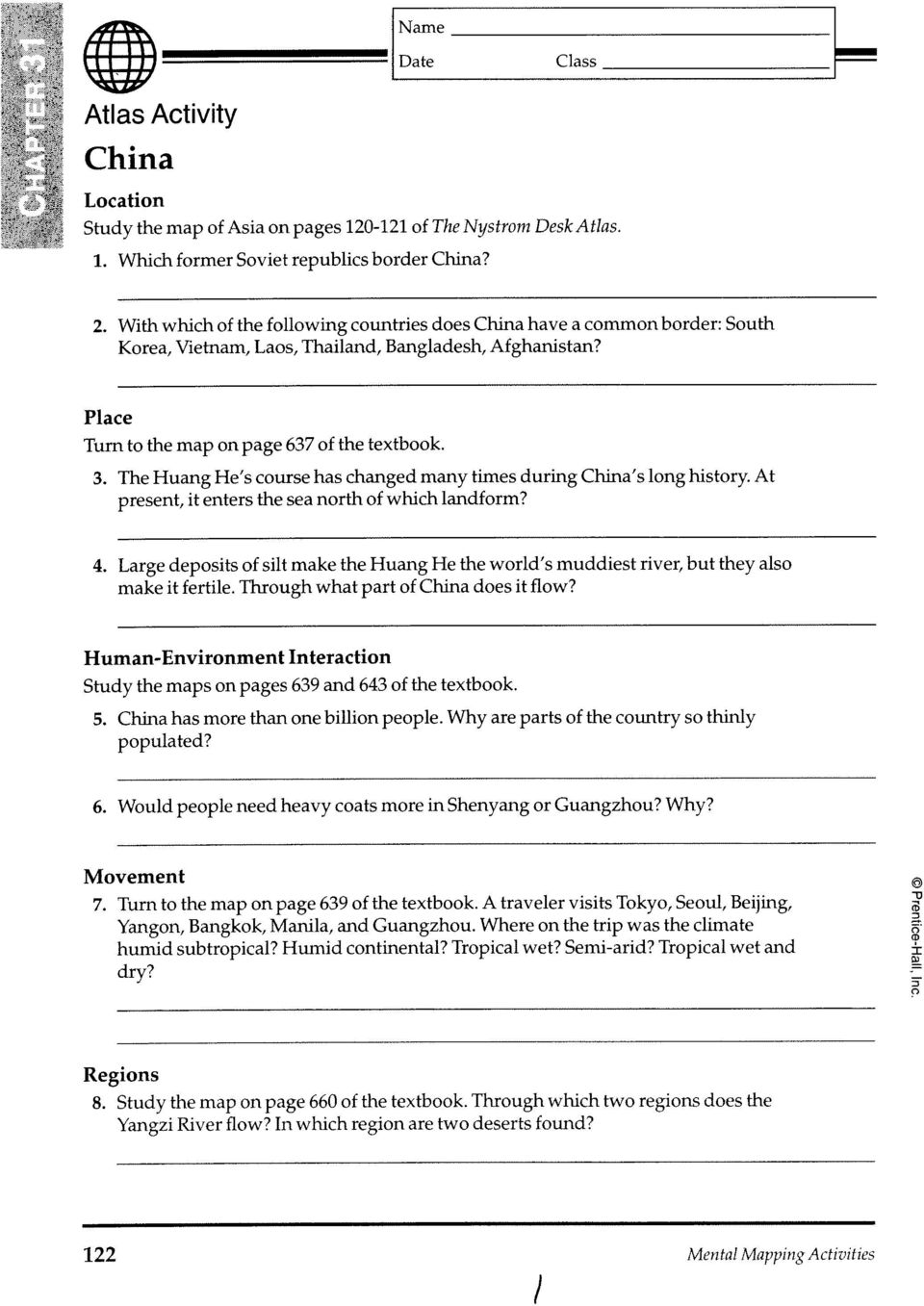
2 Name Regional Atlas: Introduction to East Asia and the Pacific World Study the maps on pages 635 and 637 of the textbook. 1. What sea separates South Korea from China? CHAPTER Name and describe the location of Australia s principal mountain range. 3. What country lies west of the Gulf of Tonkin? What is its capital? Study the political map on page 123 of The Nystrom Desk Atlas. 4. What country borders Brunei, Indonesia, and Thailand? 5. What two large islands does the Equator cross in the country of Indonesia? Study the balance of trade graphs on page 125 of the Nystrom atlas. 6. Which country exports a greater percentage of goods to the United States: South Korea or Japan? 7. What is the approximate dollar value of Japan s exports to the United States? What is the value of its imports from the United States? 8. Look at the bicycle pictogram on page 124 of the Nystrom atlas. How many more bicycles are in use than automobiles? Why might so many of China s urban population use bicycles in their daily travels? 9. Study the map on page 637 of the textbook. What are the three great desert regions of western Australia? Mental Mapping Activities 119

3
4 Name Japan and the Koreas Study the map on page 680 of the textbook. 1. Which bodies of water separate Korea from Japan? CHAPTER At what approximate longitude is Japan s capital city of Tokyo located? 3. What port city is near Tokyo? Study the maps on pages 639 and 641 of the textbook. 4. Compare the climate regions in Japan and South Korea. 5. Is there any region of tropical rain forest in North Korea? In Japan? In South Korea? 6. What are the ecosystems on the northernmost island of Japan? 7. Study the population density map on page 643 of the textbook. Why is land very expensive in Japan? 8. Turn to the maps on pages 121 and 125 of The Nystrom Desk Atlas. A merchant vessel in Manila harbor takes on a cargo of coconuts for Fuzhou, China, and a shipment of wood veneer for Pusan, South Korea. What is the most direct route the ship can take to deliver its cargo? Study the map of East Asia on page 125 of the Nystrom atlas. 9. What are the four main islands of Japan? 10. What is Japan s largest island? What island is farthest south?. Mental Mapping Activities 125

5 CHAPTER 33 Southeast Asia Name Study the map on page 700 of the textbook. 1. Which islands, once known as the Spice Islands, lie north and south of the Equator and between Celebes and New Guinea? 2. What capital cities lie along the Mekong River? 3. Turn to the map on page 123 of The Nystrom Desk Atlas. What is the name of the country formerly known as Burma? What peninsula extends south of its southern border? 4. Find the island of Java, Indonesia, on the maps on pages 637, 641, and 645 of the textbook. A large part of the tropical rain forest is now farmed for profit. How is this indicated on the map on page 645? 5. In the Nystrom atlas, study the map of Asia on pages and the shipping routes map on page 135. Why is the Strait of Malacca between Malaysia and Indonesia one of the most important shipping lanes in the world? Turn to the map on page 703 of the textbook. 6. What European power controlled the most islands in Southeast Asia and the Pacific world in 1914? 7. Which European country controlled Indochina in 1914? 8. Which country controlled the Philippines in 1914? 9. Which country in Southeast Asia was never a European colony? 128 Mental Mapping Activities

6

7

Week 1. Week 2. Week 3
 Week 1 1. What US city has the largest population? 2. Where is Aachen? 3. What is the capitol of Florida? 4. What is the longest mountain range in Spain? 5. What countries border Equador? Week 2 1. What
Geography at GISSV: An Introduction to the Curriculum
 Geography at GISSV: An Introduction to the Curriculum Classes Geography is taught for two hours per week in Grades 5-9. The only exception is in Grade 8, where class is taught for one hour per week for
Cement and clinker trade flows in Asia
 Cement and clinker trade flows in Asia Ad Ligthart Cement Distribution Consultants 19 June 2012 General overview Region includes Indian Ocean and Pacific Ocean islands (excl. Hawaii) Global cement and
Allows teachers to print reports for individual students or an entire class.
 Map and Globe Skills Developed by teachers and geography specialists, Map and Globe Skills provides the strategies, skills and practice your students need to develop a strong understanding of basic mapping
1. Incredible India. Shade the map on the next page, to show India s relief. The correct shading is shown on the final page! Incredible India India
 1. Incredible India Shade the map on the next page, to show India s relief. The correct shading is shown on the final page! Incredible India India The DCSF supported Action plan for Geography is delivered
Prentice Hall World Geography: Building a Global Perspective 2003 Correlated to: Arkansas Social Studies Curriculum Frameworks (Grades 9-12)
") Arkansas Social Studies Curriculum Frameworks (Grades 9-12) Strand 1: Time, Continuity, and Change Content Standard 1: Students will demonstrate an understanding of the chronology and concepts of history
Arkansas Social Studies Curriculum Frameworks (Grades 9-12) Strand 1: Time, Continuity, and Change Content Standard 1: Students will demonstrate an understanding of the chronology and concepts of history
Chapter 3 Communities, Biomes, and Ecosystems
 Communities, Biomes, and Ecosystems Section 1: Community Ecology Section 2: Terrestrial Biomes Section 3: Aquatic Ecosystems Click on a lesson name to select. 3.1 Community Ecology Communities A biological
Ch.1. Name: Class: Date: Matching
 Name: Class: Date: Ch.1 Matching Match each item with the correct statement below. a. technology e. democracy b. diffusion f. extended family c. exports g. interdependence d. climate 1. goods sent to markets
Climate Change Impacts in the Asia/Pacific Region
 Climate Change Impacts in the Asia/Pacific Region Global CC threat CC in the A/P region The Stern Review and IPCC 4 th Assessment Report both state that climate change will have adverse impact on people
ANNEX TABLES Table 1. Revenue by ICT Type Revenue * Share to Total Revenues Growth Rate ICT Type 2004 2005 2004 2005 (in percent)
") ANNEX TABLES Table 1. Revenue by Revenue * Share to Revenues 2004 2005 2004 2005 Contact Centers 32,904.1 54,295.1 44.4 49.4 65.0 Medical Transcription 236.7 466.2 0.3 0.4 97.0 Animation 694.2 939.1 0.9
ANNEX TABLES Table 1. Revenue by Revenue * Share to Revenues 2004 2005 2004 2005 Contact Centers 32,904.1 54,295.1 44.4 49.4 65.0 Medical Transcription 236.7 466.2 0.3 0.4 97.0 Animation 694.2 939.1 0.9
UNIT I INTRODUCTION. This unit deals with Location space relations and India s place in the world
 UNIT I INTRODUCTION This unit deals with Location space relations and India s place in the world CHAPTER INDIA LOCATION You have already seen the map of India in the previous classes. Now you closely examine
Chapter 18 Introduction to. A f r i c a
 Chapter 18 Introduction to A f r i c a Ch. 18:1 Landforms & Resources 1. Africa s shape & landforms are the result of its location in the southern part of the ancient supercontinent of. Pangaea Over thousands
Send all inquiries to: Glencoe/McGraw-Hill 8787 Orion Place Columbus, Ohio 43240-4027 ISBN 0-07-824996-1. Printed in the United States of America
 Copyright by The McGraw-Hill Companies, Inc. All rights reserved. Permission is granted to reproduce the material contained herein on the condition that such material be reproduced only for classroom use;
Temperature, Rainfall, and Biome Distribution Lab
 Temperature, Rainfall, and Biome Distribution Lab Welcome to your climatogram lab. In this lab you will investigate the relationship between the amount of rainfall and the variance of temperature and the
A Few Facts about Antarctica
 A Few Facts about Antarctica Antarctica is the continent that surrounds the South Pole, the southernmost point at the bottom of the earth. Antarctica is a continent because it is land that is covered by
Module 11: The Cruise Ship Sector. Destination #3
 Module 11: The Cruise Ship Sector Destination #3 Cruise Destinations Welcome to your third destination. Use the following resource article to learn about the different oceans and time zones. Seen from
Key Findings (preliminary): Asia Pacific Visitor Forecasts 2014-2018 Report
: Asia Pacific Visitor Forecasts 2014-2018 Report") Key Findings (preliminary): Asia Pacific Visitor Forecasts 2014-2018 Report Please Note The findings presented here are preliminary and as delivered at the ASEAN Tourism Forum, January 2014. Final checks
Key Findings (preliminary): Asia Pacific Visitor Forecasts 2014-2018 Report Please Note The findings presented here are preliminary and as delivered at the ASEAN Tourism Forum, January 2014. Final checks
The Prediction of Indian Monsoon Rainfall: A Regression Approach. Abstract
 The Prediction of Indian Monsoon Rainfall: Goutami Bandyopadhyay A Regression Approach 1/19 Dover Place Kolkata-7 19 West Bengal India [email protected] Abstract The present paper analyses the monthly
NATURAL REGIONS OF KENTUCKY
 NATURAL WONDERS As you travel around Kentucky taking pictures, you are excited by what you see. Kentucky offers diverse and amazing sights. The Six Regions In the West, you see the Mississippi River, the
Thailand Cross Border Logistics
 - 1 - Thailand Cross Border Logistics Title Author Thailand on regional transport logistics hub. ( Vis-à-vis neighboring countries.) (Some part of this essay come from Logistics HUB written by Tanit Sorat
Stage 4. Geography. Blackline Masters. By Karen Devine
 1 Devine Educational Consultancy Services Stage 4 Geography Blackline Masters By Karen Devine Updated January 2010 2 This book is intended for the exclusive use in NSW Secondary Schools. It is meant to
Prentice Hall World Geography: Building a Global Perspective 2007
 Prentice Hall World Geography: Building a Global Perspective 2007 Grades 9-12 C O R R E L A T E D T O Louisiana Grade-Level Expectations for World Geography Grades 9-12 Geography The World in Spatial Terms
GeoPuzzle Asia Teacher Resource Guide
 GeoPuzzle Asia Teacher Resource Guide Introduction This guide is designed for teachers and parents of children ages 4-12. Combining the assembling of the GeoPuzzle Asia with some of the following questions
defined largely by regional variations in climate
 1 Physical Environment: Climate and Biomes EVPP 110 Lecture Instructor: Dr. Largen Fall 2003 2 Climate and Biomes Ecosystem concept physical and biological components of environment are considered as single,
Key Development Trends in Supply Chain Management
 Key Development Trends in Supply Chain Management November 4, 2010 A member of the Li & Fung Group Three Key Supply Chain Challenges These Days 1. Unpredictable Customer Demand 2. Sophisticated Supply
Royal University o f of A gricultur gricultur Agricultur Graduate School Low carbon activities and re Low carbon activities and r sear
 Royal University of Agriculture Graduate School Low carbon activities and research by Royal University of Agriculture Present by : Mr. KIM Soben 29 th May, 2012 Contents 1. About RUA 2. Research and development
What Causes Climate? Use Target Reading Skills
 Climate and Climate Change Name Date Class Climate and Climate Change Guided Reading and Study What Causes Climate? This section describes factors that determine climate, or the average weather conditions
CGC1D1: Interactions in the Physical Environment Factors that Affect Climate
 Name: Date: Day/Period: CGC1D1: Interactions in the Physical Environment Factors that Affect Climate Chapter 12 in the Making Connections textbook deals with Climate Connections. Use pages 127-144 to fill
CSCAP MEMORANDUM NO. 24 Safety and Security of Vital Undersea Communications Infrastructure
 CSCAP MEMORANDUM NO. 24 Safety and Security of Vital Undersea Communications Infrastructure A Memorandum from the Council for Security Cooperation in the Asia Pacific (CSCAP) May 2014 Council for Security
World Map Lesson 4 - The Global Grid System - Grade 6+
 World Map Lesson 4 - The Global Grid System - Grade 6+ Activity Goal To use the global grid system of latitude and longitude to find specific locations on a world map. Materials Needed: A pencil, a ruler,
The IPCC Special Report on Managing the Risks of Extreme Events and Disasters to Advance Climate Change Adaptation
 The IPCC Special Report on Managing the Risks of Extreme Events and Disasters to Advance Climate Change Adaptation A changing climate leads to changes in extreme weather and climate events 2 How do changes
CLIMATE, WATER & LIVING PATTERNS THINGS
 CLIMATE, WATER & LIVING PATTERNS NAME THE SIX MAJOR CLIMATE REGIONS DESCRIBE EACH CLIMATE REGION TELL THE FIVE FACTORS THAT AFFECT CLIMATE EXPLAIN HOW THOSE FACTORS AFFECT CLIMATE DESCRIBE HOW CLIMATES
Directions: Arabian Peninsula Croatia India Asia Indonesia Papua New Guinea
 In this activity, students will use a variety of skills to complete the tasks, including close reading and comprehension abilities, researching, and mapping. The reading part of this activity requires
LEARNING THE LANDFORMS Grade Level: Third Presented by: Elizabeth Turcott, Endeavor Charter Academy, Springfield, Michigan Length of Unit: 14 lessons
 LEARNING THE LANDFORMS Grade Level: Third Presented by: Elizabeth Turcott, Endeavor Charter Academy, Springfield, Michigan Length of Unit: 14 lessons I. ABSTRACT This unit develops an understanding of
Goal 2: Achieve Universal Primary Education
 92 Goal 2: Achieve Universal Primary Education In eight economies in the region including a number from the Pacific, total net enrollment ratios in primary education are below 80%. Eleven economies including
Communities, Biomes, and Ecosystems
 Communities, Biomes, and Ecosystems Before You Read Before you read the chapter, respond to these statements. 1. Write an A if you agree with the statement. 2. Write a D if you disagree with the statement.
Summarize how Portugal built a trading empire
 Objectives Summarize how Portugal built a trading empire in. Analyze the rise of Dutch and Spanish dominance in the region. Understand how the decline of Mughal India affected European traders in the region.
3. The Buddha followed some Hindu ideas and changed others, but he did not consider himself to be a god.
 True / False Indicate whether the statement is true or false. 1. Like the ancient Greeks, Indian astronomers proposed the theory that the Earth was round and revolved around the sun. 2. During his time
Page 1 of 10. Story of the week. Teens fighting robots aboard a Maersk Line container ship? Latest offers. Tuesday 16 February 2010
 Page 1 of 10 Tuesday 16 February 2010 Story of the week Teens fighting robots aboard a Maersk Line container ship? If it sounds like science fiction, well it is! Maersk Line vessels laid up at Loch Striven,
Discovering World Geography WESTERN HEMISPHERE
 WESTERN HEMISPHERE Follow Lesson Correlations for Instructional strategies that encourage the development of critical thinking, problem solving and performance skills. Custom Book: Student Edition REFERENCE
2013 Annual Climate Summary for the Southeast United States
 Months of heavy rain forced the U.S. Army Corp of Engineers to open the spillways at Lake Hartwell, located at the headwaters of the Savannah River along the South Carolina-Georgia border, on July 9,.
PACIFIC CATASTROPHE RISK ASSESSMENT AND FINANCING INITIATIVE
 PACIFIC CATASTROPHE RISK ASSESSMENT AND FINANCING INITIATIVE NIUE SEPTEMBER 11 COUNTRY RISK PROFILE: NIUE Niue is expected to incur, on average,.9 million USD per year in losses due to earthquakes and
CONFEDERATION OF ASIA-PACIFIC CHAMBERS OF COMMERCE AND INDUSTRY (CACCI)
") CONFEDERATION OF ASIA-PACIFIC CHAMBERS OF COMMERCE AND INDUSTRY (CACCI) Policy Paper on Flexible Responses to Environmental Uncertainty and Infrastructure Resolved as of 3 rd October,. A. BACKGROUND 1.
CONFEDERATION OF ASIA-PACIFIC CHAMBERS OF COMMERCE AND INDUSTRY (CACCI) Policy Paper on Flexible Responses to Environmental Uncertainty and Infrastructure Resolved as of 3 rd October,. A. BACKGROUND 1.
Five Themes of Geography
 Five Themes of Geography Studying the geography of the entire world is a huge task. You can make that task easier by using the five themes of geography: location, regions, place, movement, and humanenvironment
Washington State Industry Outlook and Freight Transportation Forecast:
 Washington State Industry Outlook and Freight Transportation Forecast: Apple Industry Prepared for the Washington State Department of Transportation Freight Systems Division By Selmin Creamer Research
CSCAP MEMORANDUM No. 15 The Security Implications of Climate Change
 CSCAP MEMORANDUM No. 15 The Security Implications of Climate Change A Memorandum from the Council for Security Cooperation in the Asia Pacific (CSCAP) June 2010 CSCAP Memorandum No. 15 The Security Implications
WORLD REGIONAL GEOGRAPHY. By Brett Lucas
 WORLD REGIONAL GEOGRAPHY By Brett Lucas PACIFIC REALM AND POLAR Defining the Realm & Regions Defining the Realm Sea Hemisphere: seas cover nearly an entire hemisphere: Fragmented, culturally complex
International Flood Network
 International Flood Network Flood Devastation Increasing Floods are natural phenomena caused by rain, but flood damage is influenced by various social as well as natural factors. The scale and form of
Trend Analysis & Scenario Planning
 Trend Analysis & Scenario Planning Thinking about future infrastructure to support higher living standards June 2013 Hosted by NIAB members with the NIU team of Carrie Cooke, Richard Ward and Roger Fairclough
APEC Business Travel Card (ABTC)
") Page 1 of 2 APEC Business Travel Card (ABTC) Tuesday, 22 June 2010 03:59 Overview APEC is an organization that formed in 1989 in creating wider economic cooperation in Asian Pacific region. There are 20
Page 1 of 2 APEC Business Travel Card (ABTC) Tuesday, 22 June 2010 03:59 Overview APEC is an organization that formed in 1989 in creating wider economic cooperation in Asian Pacific region. There are 20
Coral Triangle Initiative (CTI) on Coral Reefs, Fisheries and Food Securities
 on Coral Reefs, Fisheries and Food Securities") 2008/MRCWG/022 Agenda Item: 10 Coral Triangle Initiative (CTI) on Coral Reefs, Fisheries and Food Securities Purpose: Information Submitted by: Indonesia 21 st Marine Resource Conservation Working Group
2008/MRCWG/022 Agenda Item: 10 Coral Triangle Initiative (CTI) on Coral Reefs, Fisheries and Food Securities Purpose: Information Submitted by: Indonesia 21 st Marine Resource Conservation Working Group
UNITED NATIONS Economic and Social Commission for Asia and the Pacific 53 member States 9 associate members
 UNITED NATIONS Economic and Social Commission for Asia and the Pacific 53 member States 9 associate members South and South-West Asia Afghanistan Bangladesh Bhutan India Iran Maldives Nepal Pakistan Sri
Busiest ports. Asian Tiger. Business friendly. Highest Trade/GDP Ratio. 4 th biggest financial centre
 Busiest ports Business friendly Asian Tiger Highest Trade/GDP Ratio 4 th biggest financial centre Singapore economy at a glance: Singapore is a global trading power. Its strategic geographical location,
U.S. Agriculture and International Trade
 Curriculum Guide I. Goals and Objectives A. Understand the importance of exports and imports to agriculture and how risk management is affected. B. Understand factors causing exports to change. C. Understand
Adjectives Using Ocean Facts
 GRACE Educational Curriculum OCEANS http://www.tsgc.utexas.edu/ Teachers Grades 3-5 Language Arts Adjectives Using Ocean Facts Background Information: Teaching students to use adjectives more effectively
Climate, Vegetation, and Landforms
 Climate, Vegetation, and Landforms Definitions Climate is the average weather of a place over many years Geographers discuss five broad types of climates Moderate, dry, tropical, continental, polar Vegetation:
Monitoring Phenology Activity
 Monitoring Phenology Activity Exploring the PhenoCam Locations Introduction In this activity students become familiar with the PhenoCam website and the network by comparing the images from diverse PhenoCam
These prices are include all brokers commission (2.00 USD/MT)
") Bulk Bitumen: While we have limited possibilities to provide Bulk Vessels, we have no limitation to provide Bulk Bitumen on FOB basis if you/your customer s are capable to arrange the Bulk Vessel. Please
Bulk Bitumen: While we have limited possibilities to provide Bulk Vessels, we have no limitation to provide Bulk Bitumen on FOB basis if you/your customer s are capable to arrange the Bulk Vessel. Please
6. Base your answer to the following question on the graph below, which shows the average monthly temperature of two cities A and B.
 1. Which single factor generally has the greatest effect on the climate of an area on the Earth's surface? 1) the distance from the Equator 2) the extent of vegetative cover 3) the degrees of longitude
Key Competitors to Western North American Log and Lumber Exporters
 Key Competitors to Western North American Log and Lumber Exporters Title line 1 Title line 2 in the Pacific Rim Name Bob Flynn Title, date Director, International Timber, RISI Mapping the Course, January
LNG Poised to Significantly Increase its Share of Global Gas Market David Wood February 2004 Petroleum Review p.38-39
 LNG Poised to Significantly Increase its Share of Global Gas Market David Wood February 2004 Petroleum Review p.38-39 For the past few years LNG has experienced high levels of activity and investment in
PORT OF NEWCASTLE 2014 ANNUAL TRADE REPORT
 PORT OF NEWCASTLE 2014 ANNUAL TRADE REPORT OUR VISION Port of Newcastle s vision is to maintain Newcastle s position as one of the leading and most efficient global scale coal export ports, and facilitate
Although greatly MOUNTAINS AND SEA BRITISH COLUMBIA S AWIDE RANGE OF. Environment. Old Forests. Plants. Animals
 BRITISH COLUMBIA is Canada s westernmost province. From island-dotted Pacific coast to spectacular Rocky Mountain peak, and from hot dry grassland to moist and majestic coastal forest, British Columbia
Physiography, Geography and Climate of Latin America (Lecture 3)
") Physiography, Geography and Climate of Latin America (Lecture 3) Natural Landmarks in Latin America World's longest and second highest mountain range, and the world's highest active volcanoes. Biggest
Physiography, Geography and Climate of Latin America (Lecture 3) Natural Landmarks in Latin America World's longest and second highest mountain range, and the world's highest active volcanoes. Biggest
Overview of Asian Insurance Markets
 Overview of Asian Insurance Markets Simon Walpole Session Number: TPS2 Joint IACA, IAAHS and PBSS Colloquium in Hong Kong www.actuaries.org/hongkong2012/ Market Ranking in Asia Notes: 1. Colored boxes
Horn of Africa: Threat Factors for Commercial Shipping and Forecast of Pirate Activity Through 2009
 Horn of Africa: Threat Factors for Commercial Shipping and Forecast of Pirate Activity Through 2009 Scope Note This assessment of factors affecting pirate success and the ability of commercial vessels
Tropical Rainforest. Abiotic Factors Amount of Water, Sunlight, Soil, Precipitation
 World Biomes A biome is an area of land that shares similar temperatures and precipitation. The observation of the temperature and precipitation over a period time make up a biome s climate. Each biome
Lao Human Resources for Community Health
 Lao Human Resources for Community Health A collaborative program of the Faculty of Medicine, University of Calgary, the Lao University of Health Sciences, and the Ministries of Education and Health, in
Trends in International Moving
 95 th ANNUAL CMSA CONVENTION MAY 2013 Trends in International Moving Terry Head, President International Association of Movers IAM Who are we? The largest international trade association and advocacy group
Present Status of Coastal Environmental Monitoring in Korean Waters. Using Remote Sensing Data
 Present Status of Coastal Environmental Monitoring in Korean Waters Using Remote Sensing Data Sang-Woo Kim, Young-Sang Suh National Fisheries Research & Development Institute #408-1, Shirang-ri, Gijang-up,
Burson-Marsteller Asia-Pacific. Social Media. #Infographics H1 2011. August 2011
 Burson-Marsteller Asia-Pacific Social Media #Infographics H1 2011 August 2011 twitter.com/bmasiapacific Burson-Marsteller.Asia facebook.com/bursonmarsteller.asia Welcome 1 Asia-Pacific 2 Australia 3 China
not to be republished NCERT MAJOR LANDFORMS OF THE EARTH
 6 You must have seen some of the landform features as shown in the Figure 6.1 below. You will notice that the surface of the earth is not the same everywhere. The earth has an infinite variety of landforms.
DIVERSITY & REACH CONNECTING COAL MARKETS
 DIVERSITY & REACH CONNECTING COAL MARKETS Trafigura is a leading independent thermal coal trader. We focus on sourcing, storing, blending and delivering coal to exact customer specifications across all
Lesson Overview. Biodiversity. Lesson Overview. 6.3 Biodiversity
 Lesson Overview 6.3 6.3 Objectives Define biodiversity and explain its value. Identify current threats to biodiversity. Describe how biodiversity can be preserved. THINK ABOUT IT From multicolored coral
Occupational Health in South and South East Asia. Prof Hemantha Wickramatillake University of Brunei Darussalam
 Occupational Health in South and South East Asia Prof Hemantha Wickramatillake University of Brunei Darussalam Working Population The active work-force comprises of approximately 630 million in the Region
Recent Developments of Shipping Finance. Arnold Wu Co-Head of Transportation Sector Investment Banking Asia-Pacific BNP Paribas
 Recent Developments of Shipping Finance Arnold Wu Co-Head of Transportation Sector Investment Banking Asia-Pacific BNP Paribas Recent Developments of Shipping Finance Basel III in focus Shipyard and ship
GLOBAL REGENTS REVIEW PACKET NUMBER TWO - PAGE 1 of 23 THIS IS GLOBAL REGENTS REVIEW PACKET NUMBER TWO
 GLOBAL REGENTS REVIEW PACKET NUMBER TWO - PAGE 1 of 23 THIS IS GLOBAL REGENTS REVIEW PACKET NUMBER TWO THE TOPICS OF STUDY IN THIS PACKET ARE: GEOGRAPHY IMPACTS HOW PEOPLE DEVELOP - This topic is divided
CURRENT BORDER SECURITY ISSUES
 CURRENT BORDER SECURITY ISSUES RI-Thailand RI-Vietnam RI-Philipina RI-India India RI-Malaysia RI-Singapura RI-Timor Leste RI-Australia ZEE RI-Australia CURRENT BORDER SECURITY ISSUES GENERAL Indonesia
EXPERT MEETING on. Geneva, 24-25 September 2007. Foreign Direct Investment in Vietnam. Ms. Le Hai Van
 EXPERT MEETING on COMPARING BEST PRACTICES FOR CREATING AN ENVIRONMENT CONDUCIVE TO MAXIMIZING DEVELOPMENT BENEFITS, ECONOMIC GROWTH AND INVESTMENT IN DEVELOPING COUNTRIES AND COUNTRIES WITH ECONOMIES
ASIA AND PACIFIC VEHICLE STANDARDS & FLEETS
 ASIA AND PACIFIC VEHICLE STANDARDS & FLEETS 14 vehicles per 1000 people (), up from 11 in 1990 Afghanistan Bangladesh Bhutan Brunei Darussalam Cambodia less than three years old. Importation of used vehicles
II. Related Activities
 (1) Global Cloud Resolving Model Simulations toward Numerical Weather Forecasting in the Tropics (FY2005-2010) (2) Scale Interaction and Large-Scale Variation of the Ocean Circulation (FY2006-2011) (3)
Communities, Biomes, and Ecosystems
 Chapter Test A CHAPTER 3 Communities, Biomes, and Ecosystems Part A: Multiple Choice In the space at the left, write the letter of the term or phrase that best answers each question Part B: Matching 1
LANDFORMS OF THE EARTH STD VIII
 LANDFORMS OF THE EARTH STD VIII 1) What do you understand by the term geomorphology? A) Geomorphology is the systematic study of the Earth s relief features. Geo means earth; morph meaning form and ology
The Implications of Global Production Chain
 The Implications of Global Production Chain Xiaoping Chen Nanyang Technological University CA-EAUI Summer School 2014 FTA in East Asia Workshop Korea University, Seoul Outline The Implications of Global
The Interconnectedness of Ancient Peoples Map Study Janet Cuenca Parkway Northeast Middle School St. Louis County, Missouri
 The Interconnectedness of Ancient Peoples Map Study Janet Cuenca Parkway Northeast Middle School St. Louis County, Missouri Level: Grade 7 Length of Unit: Intermittent days throughout the school year,
DIURNAL CYCLE OF CLOUD SYSTEM MIGRATION OVER SUMATERA ISLAND
 DIURNAL CYCLE OF CLOUD SYSTEM MIGRATION OVER SUMATERA ISLAND NAMIKO SAKURAI 1, FUMIE MURATA 2, MANABU D. YAMANAKA 1,3, SHUICHI MORI 3, JUN-ICHI HAMADA 3, HIROYUKI HASHIGUCHI 4, YUDI IMAN TAUHID 5, TIEN
Thailand s Great Undeveloped Resource
 Thailand s Great Undeveloped Resource INVESTMENT STRATEGY The primary goal of is to aggregate a significant land package targeting potash, at a very low cost of entry, 6 claims for a total of 96 sq. km.
The Changing Global Economy: The Implications and Opportunities for Transportation in Atlantic Canada
 The Changing Global Economy: The Implications and Opportunities for Transportation in Atlantic Canada Atlantic Provinces Transportation Forum St. John s, NL May 30, 2007 David Chaundy, Senior Economist,
Advice For the multiple-choice questions, completely fill in the circle alongside the appropriate answer(s).
.") SPECIMEN ASSESSMENT MATERIAL GCSE GEOGRAPHY Paper 1 Living with the physical environment Specimen Materials For this paper you must have: a pencil a ruler. Time allowed: 1 hour 30 minutes Instructions
SPECIMEN ASSESSMENT MATERIAL GCSE GEOGRAPHY Paper 1 Living with the physical environment Specimen Materials For this paper you must have: a pencil a ruler. Time allowed: 1 hour 30 minutes Instructions
SECTION 3 COMMUNITY PROFILE. Geography and the Environment
 SECTION 3 This section of the Plan provides a general overview of New Hanover County and its incorporated municipal jurisdictions. This information has been updated to reflect the community profile for
Foreign Taxes Paid and Foreign Source Income INTECH Global Income Managed Volatility Fund
 Income INTECH Global Income Managed Volatility Fund Australia 0.0066 0.0375 Austria 0.0045 0.0014 Belgium 0.0461 0.0138 Bermuda 0.0000 0.0059 Canada 0.0919 0.0275 Cayman Islands 0.0000 0.0044 China 0.0000
WEATHER, CLIMATE AND ADAPTATIONS OF ANIMALS TO CLIMATE
 7 WEATHER, CLIMATE AND ADAPTATIONS OF ANIMALS TO CLIMATE TEXTBOOK QUESTIONS AND ANSWERS Q.1. Why weather changes so frequently? Ans. All changes in the weather are caused by the sun. The movement of the
The current business context and future role of LNG in Europe. Ulco Vermeulen Executive Director Participations and Business Development
 The current business context and future role of LNG in Europe Ulco Vermeulen Executive Director Participations and Business Development EBC, Amsterdam, 31 May 2013 Agenda 1 Current situation LNG market