Introduction to Station Area Planning The Charlotte Story
|
|
|
- Martina Dennis
- 8 years ago
- Views:
Transcription
1 Introduction to Station Area Planning The Charlotte Story Boston 2009 Steve Hamwey - Sasaki Associates, Inc. Troy Russ - Glatting Jackson, Inc. October 31 st, 2009

2 Station Area Planning October 15th

3 History 1994: City of Charlotte approves Centers and Corridor Vision which guides future land use and development along transportation corridors 2000: Final EIS, TOD, and PE started 2002: Final design and construction 2007: South Corridor opens

4 Project South Corridor- 9.8 miles 13 stations Cost - approximately $475M Since housing units Civic buildings - ie, Bobcat Arena, Children's Learning Center, and Johnson and Wales

5 Since Opening in 2007 Ridership is 65% over projections Daily ridership is 14,000 (vs 9,100 projected) $1.87B in new investment and developments $525M in additional real estate tax revenues CATS has received federal approval to expand the system

6 Goals for TOD To encourage land use activities that increase ridership by increasing density of development within walking distance of a transit station. Develop plans which have flexibility and can be phased over time. Integrated with the Station Area design

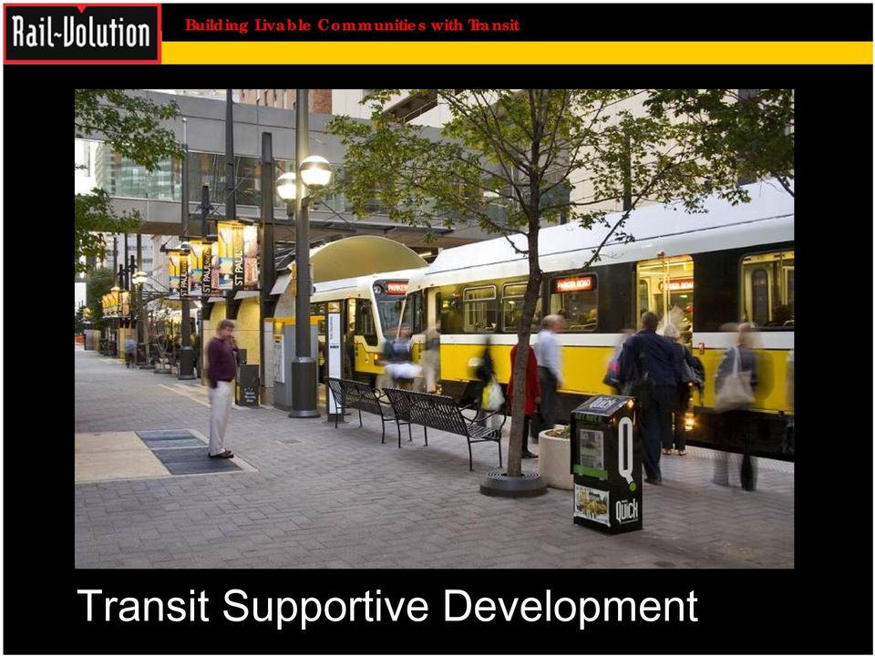
7 Transit Supportive Development
8 Why do we need planning principles? Charlotte adopted the Centers and Corridors Vision... Transit supportive design at the metro scale

9 Principles represent transit supportive design at the station area scale Transit Supportive Design Reduce time needed to walk to transit Decrease running time Time Walking to Transit Time Waiting for Transit Time Riding Transit Increase in headway frequency, therefore reducing time waiting for transit.

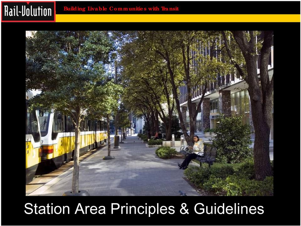
10 Station Area Principles & Guidelines
11 Land Use Mobility Community Design

12 Land Use Concentrate a mix of complementary, well integrated uses within walking distance of the transit station

13 Station Area Planning Principles Provide a mix of land uses complementary to light rail transit

14 Station Area Planning Principles Provide a mix of land uses complementary to light rail transit

15 Station Area Planning Principles Provide a mix of land uses complementary to light rail transit

16 Mobility Enhance the existing transportation network to promote good walking, bicycle and transit connections

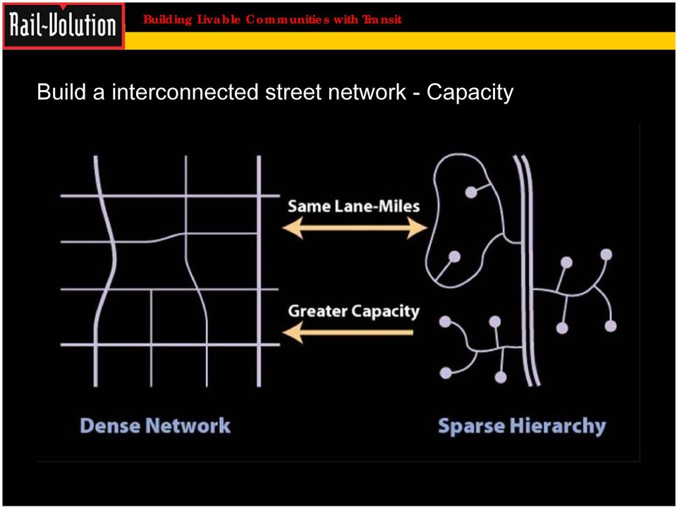
17 Build a interconnected street network - Capacity
18 Community Design Use urban design to enhance community identity of station areas and make them attractive, safe and convenient places

19 Treat the street as a public space

20 Treat the street as a public space

21 Treat the street as a public space
22 Treat the street as a public space
23 Transit & Land Use Integration Charlotte Process
24 Process The Station Location Refinement Process will be divided into three parts, each building on the results of the previous part. 1. Evaluate the spacing and service areas of the MIS-defined stations, and add, remove, or relocate stations; 2. Select specific parcel station locations; and 3. Document transit supportive station area measures and create baseline conditions for future analysis.
25 Station Location Methodology
26 Part 1 Evaluate MIS Station Spacing and Service Areas
27 Station Location Methodology The first step in the process will be evaluating each corridor's operational efficiency in serving the corridor. There are four measures that will be utilized. Two of the measures, operational spacing and effective service area, will expand analysis conducted in the MIS and measure station spacing and service characteristics. The third measure, TOD opportunities, will be used to document land development initiatives and opportunities that have arisen since the completion of the MIS. The final measure, other considerations, is intended to be a fatal flaw discussion regarding station locations and their implications.
28 Station Location Methodology Start with Adopted MIS Stations
29 Station Location Methodology Operational Spacing Analysis: This will be accomplished by testing the MIS-defined station spacing against optimal station spacing standards by mode of transit within urban and suburban locations (defined by both form and density). 1) LRT / BRT: Urban Areas - 1/2 mile spacing; Suburban Areas - 1 mile spacing 2) Commuter Rail: Urban Areas - 2 mile spacing; Suburban Areas - 5 mile spacing
30 Station Location Methodology Effective Service Area: The station area planning team will document the total area of land and land use category within a 10-minute drive of each station area using various travel times assigned to street classifications around each station. The assigned travel times will be: 10 mph for a local street, 15 mph for collector street, 25 mph for arterial street, and 45 mph for freeway. Future streets are defined by using the Adopted 2010 Thoroughfare Plan and known development opportunities.
31 Station Location Methodology TOD Opportunities: The total acreage of general transit oriented development opportunities within the actual 10-minute walk (one-half mile) will be measured for each proposed station location. Future streets are defined by using the Adopted 2010 Thoroughfare Plan and known development opportunities.
32 Station Location Methodology Develop options that shift stations to match station spacing standards, effectively serve the corridor, and support TOD opportunities.
33 Part 2 Select Station Sites
34 Station Location Methodology Determine station location: Parcel level station locations will be determined based on an integrated site selection process that utilized both operational and spatial considerations
35 Station Location Methodology Aerial Structures Grade Crossings Road & Track Realignments Engineering Requirements: These considerations will include both transit alignment (horizontal and vertical) and affected adjacent and intersecting roadway geometries.
36 Station Location Methodology Ridership: Ridership data for each station will be utilized to size the station and its facility needs.
37 Station Prototypes Park and Ride (5) I-485, Archdale, Tyvola, Woodlawn, Scaleybark Neighborhood (4) New Bern, East-West, Renselaer, Carson Walk Up (4) Convention Center, 2 nd Street, Downtown Transportation (CTC), 7 th Street
38 Station Location Methodology Ramp OCS Pole 270 Ft. (82.3 m) Station Canopy Tactile Warning Light Rail Vehicle R.O.W. Pedestrian Access Embedded Light Rail Track Ticket Vending Wind Screen/ Seating CSX Tracks Tie & Ballast Barrier Fencing Center Platform Station Adjacent to CSX Line Document Station Program and Functional Requirements: Station typologies and ridership information will be used to determine the necessary parcel size needed for each station. Potential land parcels will be evaluated for their ability to accommodate each station's programmed uses as well as each station's TOD needs and requirements.
39 Center Platform
40 Side Platform
41 Elevated Platform
42 Station Location Examples New Bern New Bern
43 Remount vs. New Bern Vacant & Under Utilized Land
44 SOUTH CORRIDOR New Bern Street Station Continue warehouse conversion to office Improve pedestrian character of South & Tryon Protect & enhance neighborhoods Improve station visibility & access to South Blvd. Potential Yard & Shop
45 NEW BERN Urban Design Plan Develop an urban neighborhood center. Protect existing neighborhoods. Convert under utilized industrial space into a mixed use office environment. Improve visibility of the LRT station.
46 NEW BERN Capital Improvements Create park as focal point of the station area. Enhance station core with streetscape and sidewalk improvements along Griffith Road, New Bern, Marsh, and South Boulevard. Create Pedestrian / Bikeway from South End to Woodlawn. Extend Old Pineville Road north from Scaleybark to Clanton Road. Require new streets as redevelopment occurs.
47 New Bern Station
48
49
50 I-485 I-485
51 Regional Location
52 The Study Area
53 Neighborhoods Sterling Neighborhood Pine Valley Neighborhood
54 Other Surrounding Uses
55 Parcels in Play
56 What will Come From this Plan? Establish a long-term vision for area Define needed land use changes Influence the form & design of coming development Identification of needed community infrastructure
57 What We Heard: Things you would like to change What s Your Vision: Things you value the most
58 Strengthening the Neighborhood
59 Access to Transit Transit
60 Key Connections Park Transit
61
62
63
64 CTC - Uptown
65
66 3 rd Street Station
67 7 th Street Station
68 CTC/Arena Station
69 platform viewing framing
70 Study Model
71
72
73 Lessons Learned Integrate TOD planner and Station Area designer Agency/City/ Stakeholder interaction and consensus with "intent" to implement Plan flexibility ( future unknown) Patience ( takes time)
74 Thank you
Light Rail Transit in Phoenix
 4. Presentation and Discussion: Phoenix Light Rail Implementation Wulf Grote Planning and Development Director, Phoenix Valley Metro Light Rail Transit in Phoenix Broadway Citizen s Task Force February
 Walkable Communities Florida Department of Transportation State Safety Office Pedestrian and Bicycle Program April 1995 www.dot.state.fl.us/safety Twelve Steps for an Effective Program Page 1 Twelve Steps
Draft Non Transportation Performance Measures Including Related Qualitative Assessment of Example Sections
 Draft Non Transportation Performance Measures Including Related Qualitative Assessment of Example Sections Phil Erickson Community Design + Architecture Mike Johnson HDR Engineering CTF Charrette Approach
S-11: Tacoma Link Extension to Tacoma Community College
 Project Number S-11 Subarea Pierce Primary Mode Light Rail Facility Type Corridor Length 3.65 miles Version ST Board Workshop Date Last Modified 11-25-2015 PROJECT AREA AND REPRESENTATIVE ALIGNMENT SHORT
Citizen Advisory Group Meeting #1 December 8, 2011 6:00 p.m.
 Citizen Advisory Group Meeting #1 December 8, 2011 6:00 p.m. Meeting Agenda 1. Background Information 2. Policy Framework 3. Plan Development Process 4. Public Input Results 5. Vision Statement 6. Group
Lincoln Downtown Master Plan Update
 Lincoln Downtown Master Plan Update Table of Contents Executive Summary........................................... 1 Complete Streets Framework.................................... 3 Promenade Creating
TCRP Report 153: Guidelines for Providing Access to Public Transportation Stations. Part 2: Station Typology and Mode of Access Planning Tool
 TCRP Report 153: Guidelines for Providing Access to Public Transportation Stations Part 2: Station Typology and Mode of Access Planning Tool Jamie Parks, AICP Kittelson & Associates, Inc. Acknowledgements
Review Public Input Report Jenn Toothaker. Approval of Meeting Summaries: May 21, May 23, May 30, & June 20, 2013 Meetings
 Call to the Audience Guidelines 2 Call to the Audience opportunities Must fill out participant card Participants called in the order cards are received 3 minutes allowed per participant CTF Facilitator
Alternatives to the Circ Project Prioritization Methodology Prepared for Circ Task Force July 28, 2011
 Alternatives to the Circ Project Prioritization Methodology Prepared for Circ Task Force July 28, 2011 CCRPC staff has developed a draft methodology described below and detailed in the attached pages for
Railyard Alternatives and I-280 Boulevard Feasibility Study. Planning Commission February 6, 2014
 Railyard Alternatives and I-280 Boulevard Feasibility Study Planning Commission February 6, 2014 Problem Statement Major pieces of new infrastructure are planned including: Downtown Rail Extension (DTX)
30 Years of Smart Growth
 30 Years of Smart Growth Arlington County s Experience with Transit Oriented Development in the Rosslyn-Ballston Metro Corridor A Presentation by the Arlington County Department of Community Planning,
Examples of Transportation Plan Goals, Objectives and Performance Measures
 Examples of Transportation Plan Goals, Objectives and Performance Measures The next step in the Long Range Transportation Plan (LRTP) process is to develop goals, objectives, and performance measures.
Near Westside Neighborhood and University Avenue Corridor Transportation Study. Public Workshop #2. September 12 and 23, 2013
 Near Westside Neighborhood and University Avenue Corridor Transportation Study Public Workshop #2 September 12 and 23, 2013 Presentation Outline: Brief Review of Study Scope, Background, and Current Conditions
HOW WILL PROGRESS BE MONITORED? POLICY AREA. 1. Implement the 2040 Growth Concept and local adopted land use and transportation plans
 PERFORMANCE MONITORING APPROACH OAR 660-044-0040(3)(e) directs Metro to identify performance measures and targets to monitor and guide implementation of the Climate Smart Strategy. The purpose of performance
I-90 ALLSTON INTERCHANGE PLACEMAKING STUDY Boston Redevelopment Authority
 I-90 ALLSTON INTERCHANGE PLACEMAKING STUDY Boston Redevelopment Authority The Cecil Group Stantec Nelson/Nygaard Task Force Presentation December 17, 2015 I-90 Allston Interchange Placemaking Study Agenda
BASSETT CREEK VALLEY MASTER PLAN OPEN HOUSE
 BASSETT CREEK VALLEY MASTER PLAN OPEN HOUSE February 23, 2006 PROJECT INTRODUCTION Project Area 230 acres $50 million estimated market value (approximately) 50 acres parkland 100 residences (estimated)
Eagle Commuter Rail Denver, Colorado Final Design (Based upon information received by FTA in November 2010)
") Eagle Commuter Rail Denver, Colorado Final Design (Based upon information received by FTA in November 2010) Summary Description Proposed Project: Electrified Commuter Rail 30.2 Miles, 13 Stations Total
Eagle Commuter Rail Denver, Colorado Final Design (Based upon information received by FTA in November 2010) Summary Description Proposed Project: Electrified Commuter Rail 30.2 Miles, 13 Stations Total
Guiding Principles. McCauley Area Focused Urban Design Plan. 1 Connect: Chinatown and Little Italy with downtown and surrounding areas
 McCauley Area Guiding Principles 1 Connect: Chinatown and Little Italy with downtown and surrounding areas 2 Strengthen: Cultural character in Chinatown and Little Italy 3 Develop: Strong East West pedestrian
How To Plan A City Of Mason
 Transportation Master Plan (TMP) for the City of Madison: Draft Scope of Work Briefing for Madison Area TPB/MPO June 6, 2012 TMP: Overview/Purpose Help Create Walkable, Bikeable, Livable City - Strengthen
STOP CONSOLIDATION TRANSIT STRATEGIES
 TRANSIT STRATEGIES STOP CONSOLIDATION Transit stops are the places where people access transit service, and greatly impact many elements of passengers transit experiences. They are typically thought of
Downtown Tampa Transportation Vision
 Downtown Tampa Transportation Vision Executive Summary August 1, 2006 Hillsborough County Metropolitan Planning Organization County Center, 18 th Floor Tampa, Florida 33602 813-272-5940 www.hillsboroughmpo.org
1. Land Use. Chapter 1: Land Use 1-1 Adopted 10/2/09 Amended 3/22/11, 8/16/11
 1. Land Use Minneapolis will develop and maintain a land use pattern that strengthens the vitality, quality and urban character of its downtown core, commercial corridors, industrial areas, and neighborhoods
EPA Technical Assistance for Sustainable Communities Building Blocks
 EPA Technical Assistance for Sustainable Communities Technical Assistance Tool: Complete Streets Deerfield Beach, Florida February 16, 2012 To: CC: Amanda Martinez, City of Deerfield Beach Roger Millar,
Schenk-Atwood Neighborhood Business District Master Plan
 Schenk-Atwood Neighborhood Business District Master Plan Prepared for the Schenk-Atwood Revitalization Association (SARA) and the City of Madison SCHREIBER/ANDERSON ASSOCIATES, INC. BEST Real Estate Group,
Sustainable urban mobility: visions beyond Europe. Brest. Udo Mbeche, UN-Habitat
 Sustainable urban mobility: visions beyond Europe 2 nd October 2013 Brest Udo Mbeche, UN-Habitat The Global Report for Human Settlements Published every two years under a UN General Assembly mandate. Aims
New Jersey SRTS Travel Plan Guide
 New Jersey SRTS Travel Plan Guide Prepared For: Funded By: Prepared By: New Jersey Department of Transportation Federal Highway Administration Alan M. Voorhees Transportation Center Edward J. Bloustein
Michael B. Hancock Mayor. October 31, 2014
 Michael B. Hancock Mayor City and County of Denver OFFICE OF THE MAYOR CITY AND COUNTY BUILDING DENVER, CO 80202-5390 TELEPHONE: (720) 865-9090 FAX: (720) 865-8787 TTY/ TTD: (720) 865-9010 October 31,
Proposed Service Design Guidelines
 Proposed Service Design Guidelines July 2015 I. Introduction During Phase II of the Reimagining CityBus project, feedback from public outreach and data analysis conducted during Phase I of the project
Tier 1 Strategies. WV Route 14 Corridor Management Plan
 1.1 1.2 1.3 1.4 Signal timing optimization system improvements. Improve geometry traffic control at high crash intersections. Construct intersection capacity improvement projects. Widen longer sections
ENGINEERING SOLUTIONS FOR DESIGNING YOUR SAFE ROUTES
 How to Get Started ENGINEERING SOLUTIONS FOR DESIGNING YOUR SAFE ROUTES Design Elements Selecting appropriate design treatments for school neighborhoods creates environments that address the needs of all
Chapter 5. Transportation. Decatur County Comprehensive Plan. Introduction. Goals and Objectives. Goal. Objectives. Goal.
 Chapter 5 Transportation Chapter 5: Transportation Introduction The transportation system forms the backbone of a community. I-74 connects Decatur County with the large metropolitan areas of Cincinnati
Addendum to the Arterial Transitway Corridors Study
 January 2013 1 Addendum to the Arterial Transitway Corridors Study The Arterial Transitway Corridors Study (ATCS) evaluated and prioritized arterial bus rapid transit (BRT) improvements to nine corridors
Chapter 9: Transportation
 Chapter 9: Transportation What is this chapter about? The goals and policies in this chapter convey the City s intent to: Create a coordinated, efficient, and more affordable multimodal transportation
ORANGE COUNTY TRANSPORTATION AUTHORITY. Final Long-Range Transportation Plan - Destination 2035. Attachment A
 ORANGE COUNTY TRANSPORTATION AUTHORITY Final Long-Range Transportation Plan - Destination 2035 Attachment A DESTINATION 2035 DESTINATION 2035 EXECUTIVE SUMMARY ATTACHMENT A Moving Toward a Greener Tomorrow
SCHOOL OF ARCHITECTURE & COMMUNITY DESIGN COLLEGE OF THE ARTS UNIVERSITY OF SOUTH FLORIDA
 SCHOOL OF ARCHITECTURE & COMMUNITY DESIGN COLLEGE OF THE ARTS UNIVERSITY OF SOUTH FLORIDA PROJECT OVERVIEW OVERVIEW The FCCD+R, in coordination with the FDOT District 7, are to facilitate numerous meetings
PINELLAS COUNTY COMPREHENSIVE PLAN
 PINELLAS COUNTY COMPREHENSIVE PLAN Future Land Use Map (FLUM) Category Descriptions and Rules Amended March 17, 2009 (Ordinance 09-17) Amended March 16, 2010 (Ordinance 10-18) Amended October 26, 2010
Los Angeles Union Station, CA Sustainable Neighborhood Assessment. April 22-23, 2014
 Los Angeles Union Station, CA Sustainable Neighborhood Assessment April 22-23, 2014 Sustainable Neighborhood Assessment Through the Sustainable Neighborhood Assessment Tool developed by Global future development
Topic 2 11/28/2012 Blocks & Street Network
 TOPIC 2 Blocks & Street Network Implementation Note: 1. Some recommendations are summarized in the tables herein. For complete recommendation language, please see the. 2. Recommendations referenced in
Proposed Program of High Capacity Transit Improvements City of Atlanta DRAFT
 I 20 West Heavy Rail Northside Drive Bus Rapid Contingent Multi Jurisdicitional Projects Atlanta Light Rail Clifton Light Rail * I 20 East Bus Rapid * Atlanta BeltLine Central Loop Irwin AUC Line Downtown
The financial plan was prepared in conjunction with the Technical Working Group. Refer to Table 3-1: Funding and Implementation Plan.
 3 Financial Plan The purpose of the financial plan is to identify funding options that would be likely sources of money to advance recommendations made by this study. The Capitol Region Transportation
DESIGN ASSISTANCE APPLICATION
 DESIGN ASSISTANCE APPLICATION for FY 2016 NEW RIVER MULTI USE PATH: PINNACLE PEAK ROAD TO HAPPY VALLEY ROAD CITY OF PEORIA APPLICATIONS ARE DUE VIA ONLINE SUBMITTAL BY 10:00 AM ON MONDAY, JUNE 29, 2015
Stone Way N Rechannelization: Before and After Study. N 34th Street to N 50th Street
 City of Seattle Department of Transportation Stone Way N Rechannelization: Before and After Study N 34th Street to N 50th Street May, 2010 INTRODUCTION Population density in Seattle is increasing within
APPENDIX F RIGHTS-OF-WAY PRESERVATION GUIDELINES
 Los Angeles County Metropolitan Transportation Authority (Metro) 2009 Transportation Improvement Program Call for Projects APPENDIX F RIGHTS-OF-WAY PRESERVATION GUIDELINES Los Angeles County Metropolitan
BIKEWAY TYPOLOGIES COMPLETE STREETS WORKSHOP JULY 2014. John Cock, Principal/Planner Alta Planning + Design
 BIKEWAY TYPOLOGIES COMPLETE STREETS WORKSHOP JULY 2014 John Cock, Principal/Planner Alta Planning + Design Alta Planning + Design Creating active communities where bicycling and walking are safe, healthy,
Goals & Objectives. Chapter 9. Transportation
 Goals & Objectives Chapter 9 Transportation Transportation MISSION STATEMENT: TO PROVIDE A TRANSPORTATION NETWORK CAPABLE OF MOVING PEOPLE AND GOODS EFFICIENTLY AND SAFELY. T he transportation system
Transportation Breakout Session. Curvie Hawkins Mark Rauscher Mike Sims Paul Moore
 Transportation Breakout Session Curvie Hawkins Mark Rauscher Mike Sims Paul Moore Curvie Hawkins Director of Planning Fort Worth Transportation Authority Fort Worth Transportation Authority The T Presented
IDOT Chicago - St. Louis High-Speed Rail Program Management
 1 www.idothsr.org www.connectthemidwest.com IDOT Chicago - St. Louis High-Speed Rail Program Management Lessons Learned: Sealing the Corridor For 110 MPH Operations Thomas W. Hunter Parsons Brinckerhoff
Evaluation Criteria and Mode Progression for RouteAhead Rapid Transit Projects
 Evaluation Criteria and Mode Progression for RouteAhead Rapid Transit Projects C2012-0684 ATTACHMENT 2 The RouteAhead draft 30-year rapid transit plan was developed in coordination with the Investing in
VISION, DESIGN PRINCIPLES & OVERALL PLANNING STRATEGY
 3 VISION, DESIGN PRINCIPLES & OVERALL PLANNING STRATEGY The overall planning strategy for the Bank Street CDP is to ensure that future development is undertaken in a coordinated and planned approach, supported
South Waterfront Area Dave Unsworth
 South Waterfront Area Dave Unsworth TriMet Capital Projects September 14, 2011 Presentation outline Background Partnering Agreements Project descriptions OHSU Portland Aerial Tram New Campus Portland Streetcar
Executive Summary. Transportation Needs CHAPTER. Existing Conditions
 CHAPTER 1 Executive Summary The City of Forest Grove Transportation System Plan (TSP) was updated to keep it consistent with recent growth trends in the city and other transportation planning efforts in
TRANSPORTATION SERVICE STANDARDS ELEMENT GOALS, OBJECTIVES & POLICIES
 TRANSPORTATION SERVICE STANDARDS ELEMENT GOALS, OBJECTIVES & POLICIES Background One of the most critical public services provided by a community is the community s transportation system. An effective
When is BRT the Best Option? 1:30 2:40 p.m.
 TRB/APTA 2004 Bus Rapid Transit Conference When is BRT the Best Option? 1:30 2:40 p.m. Paul Larrousse Director, National Transit Institute (NTI) (Moderator) TRB/APTA 2004 Bus Rapid Transit Conference Session
Overview of the Travel Demand Forecasting Methodology
 Overview of the Travel Demand Forecasting Methodology Prepared by the Central Transportation Planning Staff (CTPS) Authors: Scott A. Peterson, Manager Ian Harrington, Chief Planner March 29, 2008 1 OVERVIEW
Smart Growth and Airport Vicinity Planning
 Smart Growth and Airport Vicinity Planning APA National Conference, Los Angeles, April 2012 Mark Johnson, AICP, Ricondo & Associates, Inc. Ben Herman, FAICP, Clarion Associates, LLC Michael Armstrong,
CITY OF BRAMPTON STREET CORRIDOR MASTER PLAN
 1.0 INTRODUCTION... 1 1.1 Purpose of Document... 1 1.2 Master Plan Goal...1 1.3 Design Objectives... 2 1.4 Design Approach... 2 2.0 PROJECT SCOPE...2 2.1 City Context 2 2.2 Regional Context 2 3.0 DESIGN
Revere Beach Transit-Oriented Development Parcels Revere, Massachusetts. Design and Development Guidelines. Part Two.
 Revere Beach Transit-Oriented Development Parcels Revere, Massachusetts Design and Development Guidelines Request for Qualifications and Expressions of Interest with Preliminary Development Plans Part
Section ALTERNATIVES. 3. Alternatives
 Section 3 ALTERNATIVES 3. Alternatives 3.0 Alternatives The Springfield Rail Improvements Project Build Alternatives would utilize different routes. The No Build Alternative includes the continuation of
3 Tappan Zee Bridge Rehabilitation Options
 3 Tappan Zee Bridge Rehabilitation Options 3.1 Introduction This chapter describes possible options that rehabilitate and enhance the existing Tappan Zee Bridge. Four Rehabilitation Options have been developed:
Transportation & Planning Committee Thursday, April 23, 2015 12:00 1:30 p.m. Charlotte-Mecklenburg Government Center Room 280
 Transportation & Planning Committee Thursday, April 23, 2015 12:00 1:30 p.m. Charlotte-Mecklenburg Government Center Room 280 Committee Members: Staff Resource: Vi Lyles, Chair David Howard, Vice Chair
Strategic Regional Transit Plan
 Strategic Regional Transit Plan December 2008 Chapter 6: Run Time nalysis (Chapter 6 originally prepared October 2007) RUN TIME NLYSIS TLE OF CONTENTS 1.0 INTRODUCTION... 1 2.0 SCREEN TWO LTERNTIVES...
Market Analysis for Padre Boulevard Initiative in the Town of South Padre Island, TX
 Market Analysis for Padre Boulevard Initiative in the Town of South Padre Island, TX Prepared for Gateway Planning Group Spring 2010 TXP, Inc. 1310 South 1st Street; Suite 105 Austin, Texas 78704 (512)
CITY OF FLORENCE NEIGHBORHOOD REVITALIZATION STRATEGY SECOND PUBLIC MEETING
 CITY OF FLORENCE NEIGHBORHOOD REVITALIZATION STRATEGY SECOND PUBLIC MEETING Prepared for: City of Florence July 7th, 2014 AGENDA Review Feedback from First Community Meeting Present Catalytic Project Areas
5.0 FINANCIAL ANALYSIS AND COMPARISON OF ALTERNATIVES
 5.0 FINANCIAL ANALYSIS AND COMPARISON OF ALTERNATIVES 5.1 FINANCIAL ANALYSIS The cost of a transportation investment falls into two categories: capital costs, and operating and maintenance (O&M) costs.
SAN DIEGO - A BICYCLE FRIENDLY CITY
 SAN DIEGO - A BICYCLE FRIENDLY CITY MANY OPPORTUNITIES FOR IMPROVEMENT SUMMARY The designated bicycle paths and lanes in the City of San Diego (City) are often substandard because of their location and
Transportation Alternatives
 1 Transportation Alternatives Transportation alternatives involve a variety of components: Location Alternatives - when and where service is provided - general location as well as level of service on the
Questions and Answers about the Orange Bus/Rail Investment Plan
 Why are transit improvements needed? Questions and Answers about the Orange Bus/Rail Investment Plan The Triangle Region is now home to 1.5 million people. The U.S. Census and the 2035 Joint Long Range
Transportation Element
 Transportation Element Goal: To maintain and enhance mobility for residents and businesses through the creation and maintenance of a balanced system of transportation alternatives that: Provides a wide
THE IMPLICATIONS OF ALTERNATIVE GROWTH PATTERNS ON INFRASTRUCTURE COSTS
 City of Calgary THE IMPLICATIONS OF ALTERNATIVE GROWTH PATTERNS ON INFRASTRUCTURE COSTS REPORT APRIL 2, 2009 IBI GROUP REPORT City of Calgary EXECUTIVE SUMMARY Purpose of Report Calgary has seen record
A Bicycle Accident Study Using GIS Mapping and Analysis
 A Bicycle Accident Study Using GIS Mapping and Analysis Petra Staats, Graduate Assistant, Transportation Policy Institute, Rutgers University, New Brunswick, NJ, USA pstaats@eden.rutgers.edu Summary Surveys
APPENDIX F:TRIPLE BOTTOM LINE ANALYSIS
 APPENDIX F:TRIPLE BOTTOM LINE ANALYSIS Triple Bottom Line Analysis Map (TBLAM) Project or Decision: College Ave Corridor for FC Moves long range transportation plan for College Ave., for redevelopment
From Mobility to Accessibility: Addressing the Barrier Effect of Railway Infrastructure in Urban South Africa
 des s Publics From Mobility to Accessibility: Addressing the Barrier Effect of Railway Infrastructure in Urban South Africa Sisa Maboza Rail Planner Passenger Rail Agency of SA Contents des s Publics 1.
System Access Issue Paper (Draft)
") Regional Transit Long-Range Plan Update System Access Issue Paper (Draft) 401 South Jackson Street Seattle, WA 98104-2826 October, 2014 Sys tem Acc ess Iss ue Pape r (Dra ft) Contents 1 Executive Summary
Regional Transit Long-Range Plan Update System Access Issue Paper (Draft) 401 South Jackson Street Seattle, WA 98104-2826 October, 2014 Sys tem Acc ess Iss ue Pape r (Dra ft) Contents 1 Executive Summary
Jess Linn Principal Planner, Development Services Division Miami-Dade Regulatory and Economic Resources
 Eric Silva, AICP Assistant Director, Development Services Division Miami-Dade Regulatory and Economic Resources Albert Hernandez, P.E. Deputy Director, Planning and Engineering Miami-Dade Transit Jess
COUNTY OF ALBEMARLE PLANNING STAFF REPORT SUMMARY. Staff: Claudette Grant
 COUNTY OF ALBEMARLE PLANNING STAFF REPORT SUMMARY Project Name: ZMA 2013-00004 Hollymead Town Center Block VI Planning Commission Public Hearing: July 29, 2014 Staff: Claudette Grant Board of Supervisors
Florida Avenue Multimodal Transportation Study. June 19, 2013
 Florida Avenue Multimodal Transportation Study June 19, 2013 Today s Agenda Team & project introduction Project Timeline What you said Tools we use Mapped data and what clues it can provide Highlights
Attachment B Policy Audit Template
 Attachment B Policy Audit Template 5 6 7 8 9 0 Provide A Variety of Transportation Choices Provide A Variety of Transportation Choices Provide A Variety of Transportation Choices Encourage transit-oriented
Multi-Modal Corridor Degree of Complexity: High Cost/Benefit: High
 Multi-Modal Corridor Degree of Complexity: Cost/Benefit: Maintain the same level of service for Ensures continuous flow through the Might impact other transportation Consider road diet and/or different
Section 2 Alternatives
 Section 2 Alternatives 2.1 Introduction As part of the planning process, and in accordance with NEPA and FHWA guidelines, various alternatives were considered for meeting transportation needs within the
Appendix J Santa Monica Travel Demand Forecasting Model Trip Generation Rates
 Appendix J Santa Monica Travel Demand Forecasting Model Trip Generation Rates SANTA MONICA TRAVEL DEMAND FORECASTING MODEL TRIP GENERATION RATES SUBMITTED BY: 201 Santa Monica Blvd., Suite 500 Santa Monica,
The LYNX Transit Master Plan. METROPLAN Orlando Presentation
 2030 Paw Print: The LYNX Transit Master Plan D b 2010 December 2010 METROPLAN Orlando Presentation Project Partners Project Overview 18 Corridors Bridge between 5 Year Service Plan and Long Range Transportation
Industrial Suburban District Regulations City of St. Petersburg City Code Chapter 16, Land Development Regulations
 16.20.110 - Industrial Suburban District ( IS ) Figure REFERENCE Typical Buildings in the IS District Figure REFERENCE Site Plan of a typical development in the IS District Sections: 16.20.110.1 Composition
Technical Memorandum PERFORMANCE MEASURES. Prepared by:
 Technical Memorandum PERFORMANCE MEASURES Prepared by: March 2014 TABLE OF CONTENTS Executive Summary... 1 1. Introduction... 2 1.1 Performance Measures and the Public Sector... 2 1.2 National Focus: MAP
Evanston Main Street Station TOD Plan and Study. Appendix A.1: Station Area Existing Conditions
 Evanston Main Street Station TOD Plan and Study Appendix A.1: Station Area Existing Conditions EvanstonMainStreetStation TODPlanandStudy A 1 AppendixA.1: ExistingConditions Table of Contents Station Locations
to provide a framework within which the City Council and Mayor can evaluate and compare proposed uses of tax increment financing TIF; and
 Note: Minneapolis Tax Increment Financing Policy Proposed Amendment July 8, 2011; Revised October 12, 2011 Additions proposed in the July 8 version are indicated by underlining; deletions are indicated
College of Southern Maryland. Hughesville Transportation Study
 College of Southern Maryland Project Overview Existing Conditions Transit Service Land Use CSM Student Demographics Recommendations Methodology Transit Recommendations Transportation Demand Management
University of Missouri-St. Louis North Station
 University of Missouri-St. Louis North Station This station profile describes existing conditions around the UMSL North MetroLink Station. This is one of a set of profiles for each of the MetroLink System
Comprehensive Plan Policies that support Infill and Mixed Use
 Comprehensive Plan Policies that support Infill and Mixed Use Introduction A comprehensive plan provides a broad vision for the future growth of a community. It is often formulated using community visioning
BACKGROUND REPORT for the Peoria-Smith Station Area Plan
 BACKGROUND REPORT for the Peoria-Smith Station Area Plan Peoria-Smith station I-225 Corridor City of Aurora October, 2009 Acknowledgements Mayor Mayor Ed Tauer City of Aurora Planning Department Robert
Downtown Core Sub-district
 3-10 Land Use Downtown Core Sub-district District development will be most intense and most urban in character in the Downtown Core. The objective is to establish this area as a citywide and regional retail
DIVISION STREET CORRIDOR STRATEGY Arlington, Texas May 17, 2012
 DIVISION STREET CORRIDOR STRATEGY Arlington, Texas May 17, 2012 Project Review: DCAC Meeting #2 March 8, 2012 Reviewed stakeholder meetings Online survey findings Market Assessment Macro Market Factors,
Volume II Recommendations January 2006 City of Madison Comprehensive Plan
 2 LAND USE THE PLAN: GOALS, OBJECTIVES, POLICIES AND IMPLEMENTATION RECOMMENDATIONS Volume II Recommendations January 2006 TABLE OF CONTENTS Land Use Overview...2 1 Summary of Land Use Issues...2 2 Accommodating
Mayors Welcome Strong Surrey Votes Yes Coalition Support. Yes Vote Would Vastly Improve Transit and Transportation in Fast Growing City
 Mayors Welcome Strong Surrey Votes Yes Coalition Support Yes Vote Would Vastly Improve Transit and Transportation in Fast Growing City February 11, 2015 Vancouver, BC The Mayors Council on Regional Transportation
2010 Salida Community Priorities Survey Summary Results
 SURVEY BACKGROUND The 2010 Salida Community Priorities Survey was distributed in September in an effort to obtain feedback about the level of support for various priorities identified in the draft Comprehensive
Near West Side Comprehensive Plan Executive Summary (Revised) April 2004 City of Milwaukee DCD
 April 2004 City of Milwaukee DCD") Near West Side Comprehensive Plan Executive Summary (Revised) April 2004 City of Milwaukee DCD Boundaries The Near West Side Comprehensive Plan covers a broad area immediately west of Milwaukee s downtown.
Near West Side Comprehensive Plan Executive Summary (Revised) April 2004 City of Milwaukee DCD Boundaries The Near West Side Comprehensive Plan covers a broad area immediately west of Milwaukee s downtown.
Corridor Goals and Objectives
 Corridor Goals and Objectives This chapter presents the goals and objectives, developed by the Corridor Study Committee, that serve as the purpose and intent of the Corridor Plan. This plan covers a twenty
SYSTEMWIDE REQUIREMENTS
 SYSTEMWIDE REQUIREMENTS for the Peninsula Rail Program San Francisco to San Jose on the Caltrain Corridor Description of the Systemwide Context for the High Speed Train Project This document provides a
South Florida East Coast Corridor (SFECC) Projects. February 7, 2012
 Projects. February 7, 2012") Project Update to City of Ft. Lauderdale Central lbroward deast West ttransit it& South Florida East Coast Corridor (SFECC) Projects February 7, 2012 Transit Studies Building a network of premium transit.
Project Update to City of Ft. Lauderdale Central lbroward deast West ttransit it& South Florida East Coast Corridor (SFECC) Projects February 7, 2012 Transit Studies Building a network of premium transit.
Indianapolis SDAT. Neighborhood Restoration
 Neighborhood Restoration Working Toward a Sustainable Future live * work * play October 30 th, 2009 Message Hear concerns Build consensus Provide Recommendations Transition from Fragmentation/disconnect
South Carolina Multimodal Transportation Plan Vision, Goals, Objectives, and Performance Measures
 South Carolina Multimodal Transportation Plan Vision, Goals, Objectives, and Performance Measures Prepared for: Prepared by: June 2013 TABLE OF CONTENTS 1. Introduction... 1 1.1 Baseline Understanding...