South Waterfront Area Dave Unsworth
|
|
|
- Sharleen Regina McKenzie
- 8 years ago
- Views:
Transcription
1 South Waterfront Area Dave Unsworth TriMet Capital Projects September 14, 2011

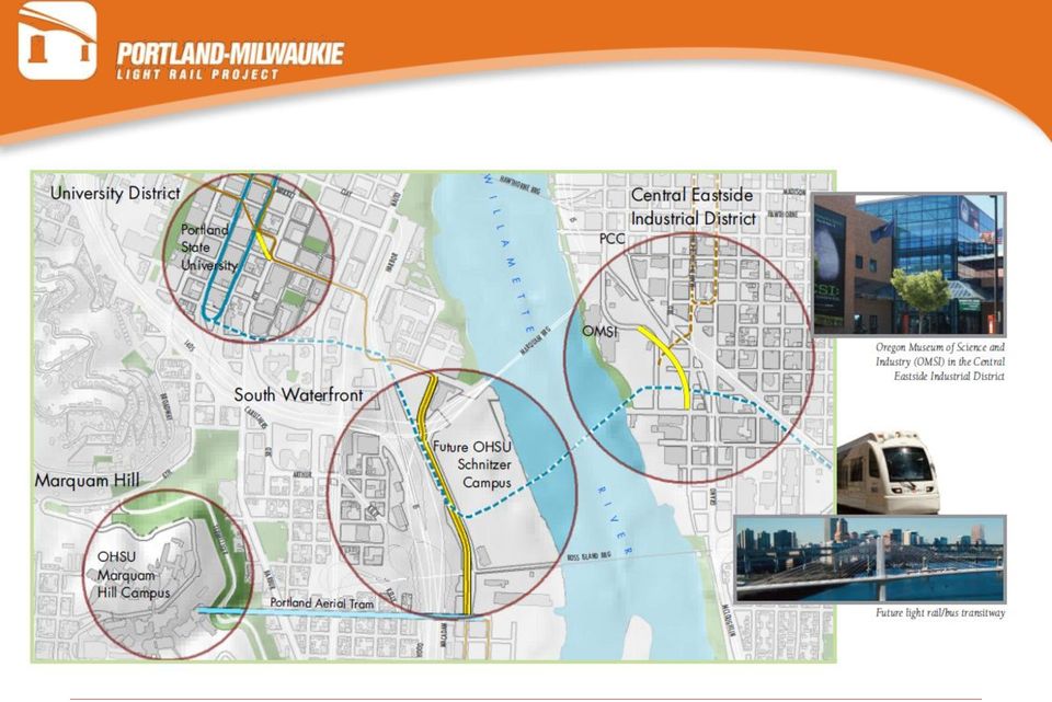
2 Presentation outline Background Partnering Agreements Project descriptions OHSU Portland Aerial Tram New Campus Portland Streetcar SW Moody Project Portland Parks Portland-Milwaukie Light Rail Project

3

4
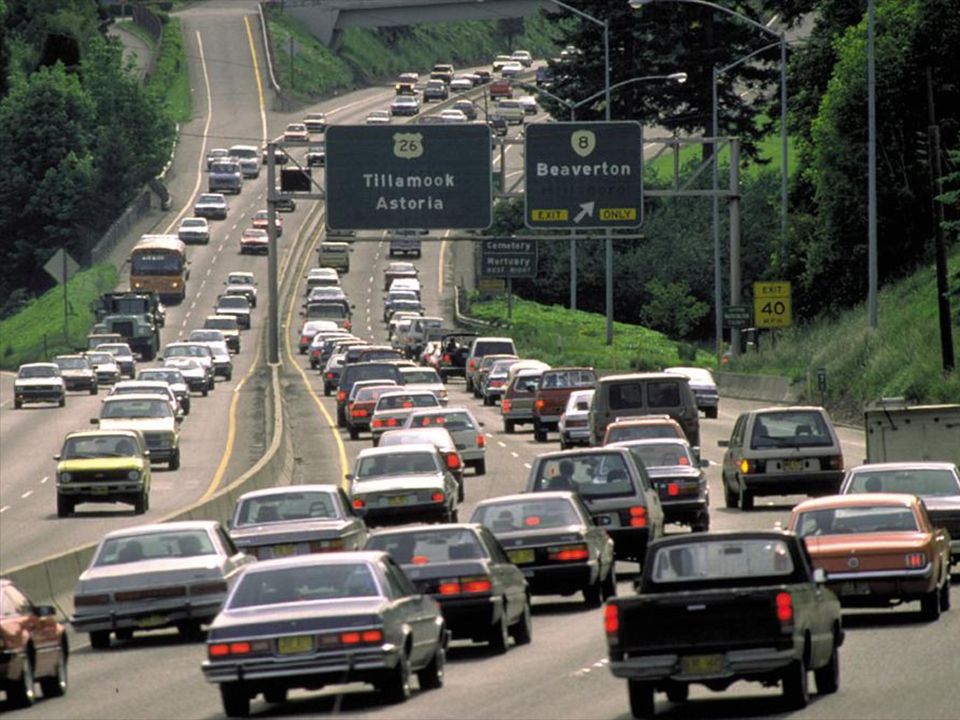
5 Pavin Paradise 1960 s freeways planned for everywhere Focused on getting people out of the city Significant costs


6 Highway Construction Has to be a better way Light Rail suggested Edmonton Calgary San Diego

7 Sprawl 1960 and 70 s significant growth Large agricultural and forest resources Conflict between uses Creation of an Urban Growth Boundary and comprehensive planning

8 Oregon Land Use Planning Comprehensive Planning Cities, Counties to prepare plans to address 19 Rules Urban growth Boundary Protection of open space, rivers and wetlands Transportation planning rule Debate on-going

9

10 2040 Growth Concept 1995 Significant public involvement Hold the Urban Growth Boundary Accentuate center and corridors Connect centers with high capacity transit

 Neighborhoods (single family residential areas to be protected) Town Center (downtown Lake")
11 2040 Growth Concept details Central City (Portland and including South Waterfront) Corridor (showing transit connection between Central City and downtown Lake Oswego) Neighborhoods (single family residential areas to be protected) Town Center (downtown Lake Oswego)
 Town Center (downtown")
12 District Connections

13
14 South Waterfront District Oregon Health & Science University Campus PSU and Downtown Portland South Waterfront District


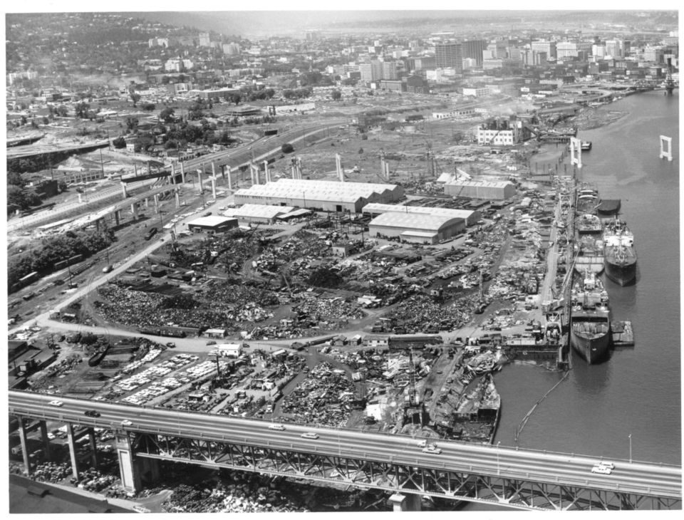
15 South Waterfront Largely underdeveloped and blighted land Identified as future core residential and employment area by 1988 Central City Plan Urban Renewal Area established in 1999


16 South Waterfront 130 acres within North Macadam URA Includes the 31-acre Central District Located within the 409-acre North Macadam Urban Renewal Area 1.2 miles of Willamette River frontage Immediately south of RiverPlace and part of the Central City Background

17 Challenges for Redevelopment of South Waterfront Brownfield area Heavy industrial history/ vacant lands/degraded riverbank Lack of infrastructure such as utilities, road network, etc. Lack of access to regional transportation system Constrained public funding Lack of development interest

18

19

20 South Waterfront North District

21 South Waterfront District New extension of Downtown Central District 5,000 jobs and 2,700 housing units District at Build-Out 10,000 jobs and 5,000 housing units
22 South Waterfront: Central District OHSU, NMI and PDC execute Development Agreement in 2003 Covered 31 acres 2,600 residential units (430 affordable units) 1.5m sf OHSU research/ clinical/education uses 5,000 new jobs Greenway improvements 2- acre neighborhood park
23 Financing Mix of public and private investment (OHSU, private developers, City) Total anticipated investment of over $2 billion at build-out. Early infrastructure primes the South Waterfront District for redevelopment. Phase 1 Investments $440 million in private investment $122 million in public projects (public & private sources) $70 million in public sources ($30.8 million of Tax Increment Financing) $52 million in private sources (Local Improvement District funds) City Construction Responsibilities Street Infrastructure Streetcar Tram Parks and Greenway South Waterfront Phase 1: Development Agreement
24 Street Infrastructure Start by providing key roadway access and laying out street system
25 Oregon Health Science University Portland Aerial Tram New Campus
26 OHSU Marquam Hill Campus Two Hospitals Regional Trauma Center Nursing School Medical School Numerous Clinics Research Facilities 11,000 Jobs Thousands of patients and visitors Located at the top of a hill with limited access
27 OHSU Marquam Hill Campus OHSU campus is built out OHSU is expanding and owned suburban site OHSU accepted a donation of 26 acres in SOWA area New Buildings planned Collaborative Life Science Building How to connect campuses?
28 New OHSU Schnitzer Campus
29 New OHSU Schnitzer Campus Ground breaking for two new buildings Oct 2011
30 South Waterfront and OHSU How to make the link?
31 Portland Aerial Tram
32 Portland Aerial Tram Transportation Capacity 900 people per hour per direction capacity Shuttle bus option only had capacity for 180 passengers per hour Travel Time 3 minutes regardless of surface traffic conditions Neighborhood Livability Lowest level of impact on the adjacent neighborhood due to lack of structures, noise and reduced number and frequency of vehicles required Maintenance and Safety Considerations Tram technology is the most reliable and mechanically simple of aerial technology Development Impacts Provides the economic spark for the South Waterfront District spurring redevelopment
33 Tram Operations Ridership 5,000 AWD 200 bikes 90% OHSU staff, students, patients 10% Public Riders Public Fare $4.00 round trip fare (per rider) Covers City contribution to Tram operations Additional valid fare instruments include: TriMet annual and monthly transit passes OHSU badges and OHSU courtesy tickets OHSU pays for OHSU riders (85% of total cost)
34 Who owns the Tram? The Portland Aerial Tram is part of Portland's public transportation system, and is owned by the city. Cost - $57M OHSU - $40 million City of Portland Urban Renewal - $8.5 million Local Improvement District - $5.6 million Developers - $2.5 million OHSU oversees operation of the Tram the city is responsible for the maintenance of the upper and lower stations and tower, and provides regulatory oversight.
35 Bicable Aerial Tram 2 Stationary track ropes per side 35
36 Bicable Aerial Tram 2 Stationary track ropes per side 1 Circulating haul rope 36
37 Bicable Aerial Tram 2 Stationary track ropes per side 1 Circulating haul rope 2 Cabins, 80 passengers each 12 Ton cabins 37
38 Bicable Aerial Tram 2 Stationary track ropes per side 1 Circulating haul rope 2 Cabins, 80 passengers each 12 Ton cabins 1,000,000 lbs. of force in tension 38
39 Construction Challenges Engineering/Constructability challenges Cantilevered structure, 1 Million Lbs of force, 160 feet in the air Tower with 3 inches of tolerance
40 Construction Challenges Constrained Construction Site Upper station site with 50 feet of footing between 2 hospital buildings
41 South Waterfront Development
42 South Waterfront Phase I 9 towers constructed 16-story OHSU Center for Health and Healing 21 and 24 story Meriwether Towers 31 story John Ross 22 story Atwater Place 31 story Ardea 22 story Rivera on the Park 30 story Mirabella 7- story Matisse
43
44
45
46 South Waterfront North District Two Property owners OHSU 26 acre Schnitzer Campus Ground breaking for first two buildings Zidell Realty 30 acre Significant Hazmat ($20m) Preparing for future development Barge building business to remain active


47 OHSU Schnitzer Campus 26 acres Zidell Realty 30 acres South Waterfront North District
48 New OHSU Schnitzer Campus
49 Portland Streetcar
50 Portland Streetcar
51 Portland Streetcar Owned by the City of Portland and operated in partnership with TriMet Streetcar is managed by Portland Office of Transportation City contracts with Portland Streetcar Inc. (nonprofit) to construct and operate streetcars Streetcar is staffed by a combination of City of Portland and TriMet employees with consulting staff from Portland Streetcar Inc.
52 Service began in 2001 locally funded Expanded to SOWA To SW Gibbs in 2006 To SW Lowell in 2007 Currently 4 miles (8 mile round trip) Portland Streetcar
53 Portland Streetcar Loop Project Small Starts approval 2009 Difficult discussion with related to user benefits and cost effectiveness 3.3 mile extension $157m Serves eastside and will cross new light rail bridge in Made in USA vehicles
54 Ridership Weekday 12,131 Sat 10,919 Sun 6,712
55 SW Moody Project
56 SW Moody Street Project rebuilds roadway and utilities to accommodate growth Converts single track streetcar to double track Adds capacity for bike and pedestrians Raise the roadway for LRT crossing and to allow brownfield redevelopment more effective (less digging into the ground for parking) Tiger I funding Completed by February 2012
57
58 Parks
59 City of Portland installed Elizabeth Caruthers Park in 2010 Future parks planned in Central district Greenway improvements shared between City and private developers. TriMet is investing $1m for environmental mitigation SOWA Parks
60 Central District Greenway
61 Portland-Milwaukie Light Rail Project
62 Project Overview 7.3-mile light rail extension Up to 25,500 weekday rides by 2030 Improved light rail, bus, streetcar, bike/ped and freight service Two Park & Ride lots Up to 460 bike spaces New multi-modal bridge Up to 14,000 jobs
63
64 Portland-Milwaukie Light Rail Bridge
65 Cable Stayed Bridge 1,720 feet long feet of vertical clearance Bus, light rail vehicles and future streetcar Two 14-foot bike/ped paths
66 Portland-Milwaukie Light Rail Bridge
67 South Waterfront Station
68 Soil re-use area
69
70 Dave Unsworth Deputy Project Director TriMet
Public. A history of public transit in Portland. trimet.org/history. Hilary Pfeifer. Meredith Dittmar. Melody Owen. Mark Richardson Smith
 Hilary Pfeifer Meredith Dittmar Public Transit A history of public transit in Portland Melody Owen Mark Richardson Smith Kristin Mitsu Shiga Chandra Bocci trimet.org/history Traveling through time Dear
Meeting Summary. Meeting Summary Contact: 1 Lauren Golden, Parametrix 503-963-7017
 North Macadam Transportation Development Strategy Scoping Team Meeting #1 Wednesday, May 9, 2007 Portland Building, 1120 SW 5th Ave. Blazed Alder Room, Third Floor 8:00 10:00 AM Meeting Summary Scoping
Executive Summary. Does a Streetcar Make Sense in Anaheim
 Does a Streetcar Make Sense in Anaheim Streetcar in Portland s Pearl District Anaheim s proposed streetcar compares well with national best practice in Portland, Seattle and Tampa where new streetcars
Chapter 9: Transportation
 Chapter 9: Transportation What is this chapter about? The goals and policies in this chapter convey the City s intent to: Create a coordinated, efficient, and more affordable multimodal transportation
Eagle Commuter Rail Denver, Colorado Final Design (Based upon information received by FTA in November 2010)
") Eagle Commuter Rail Denver, Colorado Final Design (Based upon information received by FTA in November 2010) Summary Description Proposed Project: Electrified Commuter Rail 30.2 Miles, 13 Stations Total
Eagle Commuter Rail Denver, Colorado Final Design (Based upon information received by FTA in November 2010) Summary Description Proposed Project: Electrified Commuter Rail 30.2 Miles, 13 Stations Total
Mid-Coast Corridor Transit Project San Diego, California New Starts Project Development (Rating Assigned November 2014)
") Mid-Coast Corridor Transit Project San Diego, California New Starts Project Development (Rating Assigned November 2014) Summary Description Proposed Project: Light Rail Transit 10.9 Miles, 9 Stations Total
Mid-Coast Corridor Transit Project San Diego, California New Starts Project Development (Rating Assigned November 2014) Summary Description Proposed Project: Light Rail Transit 10.9 Miles, 9 Stations Total
TCRP Report 153: Guidelines for Providing Access to Public Transportation Stations. Part 2: Station Typology and Mode of Access Planning Tool
 TCRP Report 153: Guidelines for Providing Access to Public Transportation Stations Part 2: Station Typology and Mode of Access Planning Tool Jamie Parks, AICP Kittelson & Associates, Inc. Acknowledgements
The financial plan was prepared in conjunction with the Technical Working Group. Refer to Table 3-1: Funding and Implementation Plan.
 3 Financial Plan The purpose of the financial plan is to identify funding options that would be likely sources of money to advance recommendations made by this study. The Capitol Region Transportation
Overview of the Travel Demand Forecasting Methodology
 Overview of the Travel Demand Forecasting Methodology Prepared by the Central Transportation Planning Staff (CTPS) Authors: Scott A. Peterson, Manager Ian Harrington, Chief Planner March 29, 2008 1 OVERVIEW
Florida s Transportation Visioning Summit Summary
 Florida s Transportation Visioning Summit Summary Introduction The Florida Department of Transportation (FDOT) convened Florida s Transportation Visioning Summit on December 17, 2014 in Lake Buena Vista.
30 Years of Smart Growth
 30 Years of Smart Growth Arlington County s Experience with Transit Oriented Development in the Rosslyn-Ballston Metro Corridor A Presentation by the Arlington County Department of Community Planning,
Goals & Objectives. Chapter 9. Transportation
 Goals & Objectives Chapter 9 Transportation Transportation MISSION STATEMENT: TO PROVIDE A TRANSPORTATION NETWORK CAPABLE OF MOVING PEOPLE AND GOODS EFFICIENTLY AND SAFELY. T he transportation system
Attachment B Policy Audit Template
 Attachment B Policy Audit Template 5 6 7 8 9 0 Provide A Variety of Transportation Choices Provide A Variety of Transportation Choices Provide A Variety of Transportation Choices Encourage transit-oriented
Downtown Tampa Transportation Vision
 Downtown Tampa Transportation Vision Executive Summary August 1, 2006 Hillsborough County Metropolitan Planning Organization County Center, 18 th Floor Tampa, Florida 33602 813-272-5940 www.hillsboroughmpo.org
2009-3. The Preservation of Local Truck Routes: A Primary Connection between Commerce and the Regional Freight Network
 2009-3 The Preservation of Local Truck Routes: A Primary Connection between Commerce and the Regional Freight Network July 2009 This Goods Movement Challenges and Opportunities Report was prepared jointly
Railyard Alternatives and I-280 Boulevard Feasibility Study. Planning Commission February 6, 2014
 Railyard Alternatives and I-280 Boulevard Feasibility Study Planning Commission February 6, 2014 Problem Statement Major pieces of new infrastructure are planned including: Downtown Rail Extension (DTX)
Light Rail Project. The Portland-Milwaukie. Connecting a metropolitan area, one segment at a time BY LESLIE FINNIGAN, SR/WA
 The Portland-Milwaukie Light Rail Project Connecting a metropolitan area, one segment at a time BY LESLIE FINNIGAN, SR/WA It has now been over a decade since the Portland-Milwaukie Light Rail Project (PMLR),
MEMORANDUM OF AGREEMENT Between THE CITY OF BALTIMORE And THE MID-ATLANTIC FEDERAL PARTNERSHIP FOR THE ENVIRONMENT
 MEMORANDUM OF AGREEMENT Between THE CITY OF BALTIMORE And THE MID-ATLANTIC FEDERAL PARTNERSHIP FOR THE ENVIRONMENT The Mid-Atlantic Federal Partnership for the Environment ( MAFPE ) and the City of Baltimore
Lents Town Center Mixed-Use Market Study Office Market Analysis Lents, Oregon
 Lents Town Center Mixed-Use Market Study Office Market Analysis Lents, Oregon Portland Development Commission January 2008 Draft Copy 9220 SW Barbur Boulevard Portland, Oregon 97219 503.636.1659 www.marketekinc.com
Chapter 13: Implementation Plan
 Chapter 13: 13.1. INTRODUCTION The purpose of the implementation chapter of the Comprehensive Plan is to set forth the actions that the City will take to ensure that the plans, programs and policies set
9 Best Practices in Transit. Best Practices in Transit Summary Transit First Bus Rapid Transit Urban Streetcars Light Rail
 9 Best Practices in Transit 9A 9B 9C 9D 9E Best Practices in Transit Summary Transit First Bus Rapid Transit Urban Streetcars Light Rail Seattle Urban Mobility Plan Best Practices Transit How can Seattle
Transportation Alternatives
 1 Transportation Alternatives Transportation alternatives involve a variety of components: Location Alternatives - when and where service is provided - general location as well as level of service on the
REINVENTING TRANSIT FROM A SOCIAL SERVICE TO A CRITICAL PUBLIC UTILITY
 REINVENTING TRANSIT FROM A SOCIAL SERVICE TO A CRITICAL PUBLIC UTILITY THE PRE 1950 PAST. Extensive networks for streetcars, trams and buses. Operated by the private sector through a system of franchises
Introduction to Station Area Planning The Charlotte Story
 Introduction to Station Area Planning The Charlotte Story Boston 2009 Steve Hamwey - Sasaki Associates, Inc. Troy Russ - Glatting Jackson, Inc. October 31 st, 2009 Station Area Planning October 15th History
Portland-Milwaukie Light Rail Transit Project. Growing Places
 Portland-Milwaukie Light Rail Transit Project Growing Places Portland-Milwaukie Light Rail Transit Project Table of Contents Preface: Neil McFarlane & Daniel W. Blocher 2 MAX Orange Line Station Areas
Salt Lake City Granary District. Transit Oriented, Mixed Use Development
 Salt Lake City Granary District Transit Oriented, Mixed Use Development Introduction Matt Dahl, Project Manager Redevelopment Agency of Salt Lake City The mission of the Redevelopment Agency of Salt Lake
Mid-Coast Corridor Transit Project San Diego, California New Starts Engineering (Rating Assigned November 2015)
") Mid-Coast Corridor Transit Project San Diego, California New Starts Engineering (Rating Assigned November 2015) Summary Description Proposed Project: Light Rail Transit 10.9 Miles, 9 Stations Total Capital
Mid-Coast Corridor Transit Project San Diego, California New Starts Engineering (Rating Assigned November 2015) Summary Description Proposed Project: Light Rail Transit 10.9 Miles, 9 Stations Total Capital
Examples of Transportation Plan Goals, Objectives and Performance Measures
 Examples of Transportation Plan Goals, Objectives and Performance Measures The next step in the Long Range Transportation Plan (LRTP) process is to develop goals, objectives, and performance measures.
Presentation to Community Task Force July 9, 2007
 Alternative Evaluation Results Presentation to Community Task Force July 9, 2007 Outline of Presentation Overview of alternative evaluation Alternative evaluation methodology Process and assumptions General
5.0 FINANCIAL ANALYSIS AND COMPARISON OF ALTERNATIVES
 5.0 FINANCIAL ANALYSIS AND COMPARISON OF ALTERNATIVES 5.1 FINANCIAL ANALYSIS The cost of a transportation investment falls into two categories: capital costs, and operating and maintenance (O&M) costs.
Light Rail Transit in Phoenix
 4. Presentation and Discussion: Phoenix Light Rail Implementation Wulf Grote Planning and Development Director, Phoenix Valley Metro Light Rail Transit in Phoenix Broadway Citizen s Task Force February
SOUTHWEST-TO-NORTHEAST TRANSPORTATION CORRIDOR STUDY
 DOCUMENT REVIEW 3.20.2015 TABLE OF CONTENTS INTRODUCTION... 1 SOUTHWEST-TO-NORTHEAST TRANSPORTATION CORRIDOR STUDY... 2 FORT WORTH PARK-AND-RIDE DEVELOPMENT STUDY... 4 JOHNSON COUNTY PASSENGER RAIL STUDY...
SYSTEMWIDE REQUIREMENTS
 SYSTEMWIDE REQUIREMENTS for the Peninsula Rail Program San Francisco to San Jose on the Caltrain Corridor Description of the Systemwide Context for the High Speed Train Project This document provides a
U.S. Department of Transportation Transportation Investment Generating Economic Recovery (TIGER) Grants
 Grants") U.S. Department of Transportation Transportation Investment Generating Economic Recovery (TIGER) Grants February 17, 2010 The U.S. Department of Transportation is proud to announce $1.5 billion in TIGER
U.S. Department of Transportation Transportation Investment Generating Economic Recovery (TIGER) Grants February 17, 2010 The U.S. Department of Transportation is proud to announce $1.5 billion in TIGER
Effect on structures. Uniform settlement - no concerns. Angular distortion - causes damage due to tensile strain
 Effect on structures Uniform settlement - no concerns Angular distortion - causes damage due to tensile strain 1/500 - safe limit for no cracking of buildings 1/150 - potential structural damage 36 37
How To Improve Service In Arundel
 Draft of Economic Development Strategy - Town of Arundel Chapter 3.3 - Infrastructure, Transportation and Zoning 1. Infrastructure The lack of infrastructure in Arundel could present significant problems
 Walkable Communities Florida Department of Transportation State Safety Office Pedestrian and Bicycle Program April 1995 www.dot.state.fl.us/safety Twelve Steps for an Effective Program Page 1 Twelve Steps
Section ALTERNATIVES. 3. Alternatives
 Section 3 ALTERNATIVES 3. Alternatives 3.0 Alternatives The Springfield Rail Improvements Project Build Alternatives would utilize different routes. The No Build Alternative includes the continuation of
SEPTEMBER 2015 SCOPE OF WORK. MONTGOMERY COUNTY PLANNING DEPARTMENT M-NCPPC MontgomeryPlanning.org
 SEPTEMBER 2015 SCOPE OF WORK MONTGOMERY COUNTY PLANNING DEPARTMENT M-NCPPC MontgomeryPlanning.org table of contents table of contents... 1 introduction... 2 planning context... 2 purpose of master plan...
Infrastructure and Growth Leadership Advisory Group Ideas and Approaches Survey
 Infrastructure and Growth Leadership Advisory Group Ideas and Approaches Survey In its second meeting, the Infrastructure and Growth Leadership Advisory Group expanded and refined the list of approaches/ideas
PORTLAND AERIAL TRAM Standard Operating Procedure Patient Users/Responsibilities
 PORTLAND AERIAL TRAM Standard Operating Procedure Patient Users/Responsibilities TRAM SOP03 Effective Date: December 14, 2007 Approved By: Portland Aerial Tram Executive Management Committee Revision Date:
Jess Linn Principal Planner, Development Services Division Miami-Dade Regulatory and Economic Resources
 Eric Silva, AICP Assistant Director, Development Services Division Miami-Dade Regulatory and Economic Resources Albert Hernandez, P.E. Deputy Director, Planning and Engineering Miami-Dade Transit Jess
Philadelphia County. Land Use and Growth Management Profile
 Philadelphia County is located in the southeastern corner of Pennsylvania and is bordered by the Pennsylvania counties of Delaware, Montgomery, and Bucks, and the New Jersey counties of Burlington, Camden,
9988 REDWOOD AVENUE PROJECT TRAFFIC IMPACT ANALYSIS. April 24, 2015
 9988 REDWOOD AVENUE PROJECT TRAFFIC IMPACT ANALYSIS April 24, 2015 Kunzman Associates, Inc. 9988 REDWOOD AVENUE PROJECT TRAFFIC IMPACT ANALYSIS April 24, 2015 Prepared by: Bryan Crawford Carl Ballard,
Mount Royal College Transit Service Plan
 Mount Royal College Transit Service Plan Background In 2007 November response to Council Report C2007-78 West LRT Alignment, Budget and Project Delivery, Council directed the Administration to report back
Narrative Response/Attachment 1 (WisDOT 2014-2018 TAP- Second Round Application ID-SWBP22)
") Narrative Response/Attachment 1 (WisDOT 2014-2018 TAP- Second Round Application ID-SWBP22) 2. For Bicycle and Pedestrian Projects: Clearly indicate the location, length, width, surface materials, and any
Narrative Response/Attachment 1 (WisDOT 2014-2018 TAP- Second Round Application ID-SWBP22) 2. For Bicycle and Pedestrian Projects: Clearly indicate the location, length, width, surface materials, and any
Comprehensive Plan Policies that support Infill and Mixed Use
 Comprehensive Plan Policies that support Infill and Mixed Use Introduction A comprehensive plan provides a broad vision for the future growth of a community. It is often formulated using community visioning
Agenda. } Beltline Study Background } PEL Basics } UW Survey Results } Strategy Development and Results } Next Steps
 Fall 2014 1 Agenda } Beltline Study Background } PEL Basics } UW Survey Results } Strategy Development and Results } Next Steps 2 Study Limits (University Avenue/US 14 to County N) 3 } Motor vehicle congestion
TRANSPORTATION SYSTEM IMPROVEMENTS
 TRANSPORTATION SYSTEM IMPROVEMENTS 3 INTRODUCTION s Transportation System Plan (TSP) guides and coordinates investment in the transportation network over the next 20 years. The plan carries out this responsibility
HOW WILL PROGRESS BE MONITORED? POLICY AREA. 1. Implement the 2040 Growth Concept and local adopted land use and transportation plans
 PERFORMANCE MONITORING APPROACH OAR 660-044-0040(3)(e) directs Metro to identify performance measures and targets to monitor and guide implementation of the Climate Smart Strategy. The purpose of performance
Legislative Fiscal Bureau One East Main, Suite 301 Madison, WI 53703 (608) 266-3847 Fax: (608) 267-6873
 266-3847 Fax: (608) 267-6873") Legislative Fiscal Bureau One East Main, Suite 301 Madison, WI 53703 (608) 266-3847 Fax: (608) 267-6873 February 16, 2010 TO: FROM: Members Joint Committee on Finance Bob Lang, Director SUBJECT: Governor's
Legislative Fiscal Bureau One East Main, Suite 301 Madison, WI 53703 (608) 266-3847 Fax: (608) 267-6873 February 16, 2010 TO: FROM: Members Joint Committee on Finance Bob Lang, Director SUBJECT: Governor's
Addendum to the Arterial Transitway Corridors Study
 January 2013 1 Addendum to the Arterial Transitway Corridors Study The Arterial Transitway Corridors Study (ATCS) evaluated and prioritized arterial bus rapid transit (BRT) improvements to nine corridors
Partnering for 21 st Century Prosperity
 Partnering for 21 st Century Prosperity UniversityCity, A Catalytic Local Project of Regional Significance FLORIDA INTERNATIONAL UNIVERSITY F L O R I D A I N T E R N A T I O N A L U N I V E R S I T Y F
BASSETT CREEK VALLEY MASTER PLAN OPEN HOUSE
 BASSETT CREEK VALLEY MASTER PLAN OPEN HOUSE February 23, 2006 PROJECT INTRODUCTION Project Area 230 acres $50 million estimated market value (approximately) 50 acres parkland 100 residences (estimated)
Corridor Goals and Objectives
 Corridor Goals and Objectives This chapter presents the goals and objectives, developed by the Corridor Study Committee, that serve as the purpose and intent of the Corridor Plan. This plan covers a twenty
Near West Side Comprehensive Plan Executive Summary (Revised) April 2004 City of Milwaukee DCD
 April 2004 City of Milwaukee DCD") Near West Side Comprehensive Plan Executive Summary (Revised) April 2004 City of Milwaukee DCD Boundaries The Near West Side Comprehensive Plan covers a broad area immediately west of Milwaukee s downtown.
Near West Side Comprehensive Plan Executive Summary (Revised) April 2004 City of Milwaukee DCD Boundaries The Near West Side Comprehensive Plan covers a broad area immediately west of Milwaukee s downtown.
Downtown South Salt Lake Redevelopment City of South Salt Lake
 Project Information LOCAL PLANNING RESOURCE PROGRAM 2015 Downtown South Salt Lake Redevelopment City of South Salt Lake Overview of Objectives: Building a downtown city center could be the most significant
12MAP-21, a funding and authorization bill to govern U.S. federal surface MONITORING IMPLEMENTATION AND PERFORMANCE
 MONITORING IMPLEMENTATION AND PERFORMANCE 12MAP-21, a funding and authorization bill to govern U.S. federal surface transportation spending, creates a data-driven, performance-based multimodal program
Waterstone Business Park
 Orange County, North Carolina Waterstone Business Park Parcel Size Price Location Zoning Topography Combined total of 47 acres (Parcel #5-22 acres, #7-25 acres) $74,545 per acre (Parcel #5), $32,880 per
 DANIEL T. SMITH, Jr. President EDUCATION Bachelor of Science, Engineering and Applied Science, Yale University, 1967 Master of Science, Transportation Planning, University of California, Berkeley, 1968
Portland Ecodistrict Pilot Program Evaluation
 Portland Ecodistrict Pilot Program Evaluation Report of Findings FEBRUARY 2015 2015 EcoDistricts. All Rights Reserved 1223 SW Washington St., Suite 200 Portland, OR 97205 TABLE OF CONTENTS Executive Summary
STOP CONSOLIDATION TRANSIT STRATEGIES
 TRANSIT STRATEGIES STOP CONSOLIDATION Transit stops are the places where people access transit service, and greatly impact many elements of passengers transit experiences. They are typically thought of
Flood Mitigation Strategy for the Milwaukee 30 th Street Corridor Redevelopment Program
 Flood Mitigation Strategy for the Milwaukee 30 th Street Corridor Redevelopment Program Eric Loucks, P.E., D.WRE Kumar Gali, P.E. June 4, 2015 Outline MMSD Service Area Problem and Challenges Solution
What we build today will create Denver s tomorrow. Signature development projects will strengthen our economy, create jobs and improve neighborhoods.
 Mayor Hancock s Vision for Building a World-Class City What we build today will create Denver s tomorrow. Signature development projects will strengthen our economy, create jobs and improve neighborhoods.
Arizona State University & City of Phoenix Partnership: Creating a Downtown Campus
 Arizona State University & City of Phoenix Partnership: Creating a Downtown Campus Raising Educational Attainment Location 2012 Population College Degree Income Scottsdale 223,514 51.9% $48,742 Chandler
Questions and Answers about the Orange Bus/Rail Investment Plan
 Why are transit improvements needed? Questions and Answers about the Orange Bus/Rail Investment Plan The Triangle Region is now home to 1.5 million people. The U.S. Census and the 2035 Joint Long Range
Public Meeting Oral Comments
 Public Meeting Oral Comments My name is Alan Atkinson. I'm here as a private landowner and developer in this area. There's three projects I'd like to mention briefly. The first one is Project 300549. It's
Oregon City Clackamas County Red Soils Campus
 Oregon City Clackamas County Red Soils Campus Clackamas County Red Soils Campus Oregon City The Clackamas County Red Soils Campus focus area is located in the City of Oregon City. It is situated approximately
The LYNX Transit Master Plan. METROPLAN Orlando Presentation
 2030 Paw Print: The LYNX Transit Master Plan D b 2010 December 2010 METROPLAN Orlando Presentation Project Partners Project Overview 18 Corridors Bridge between 5 Year Service Plan and Long Range Transportation
Transit Technology Alternatives
 Transit Technology Alternatives Fixed Guideway Systems (see http://www.apta.com/research/info/define/index.cfm) Heavy rail - HR Heavy Rail is a system that is totally separated from its surroundings and
CITY COUNCIL / PLANNING COMMISSION JOINT STUDY SESSION AGENDA REPORT
 CITY COUNCIL / PLANNING COMMISSION JOINT STUDY SESSION AGENDA REPORT MEETING DATE: SEPTEMBER 8, 2015 ITEM NUMBER: 1 SUBJECT: PROPOSED GENERAL PLAN LAND USE ALTERNATIVE FOR THE YEAR 2015-2025 GENERAL PLAN
History of the Interurban Railway System and Monroe Shops. Dallas Area Rapid Transit
 History of the Interurban Railway System and Monroe Shops Dallas Area Rapid Transit The first interurban system in Texas was built in 1901, by the Texas Traction Company. It was a 10-mile line from Sherman
Infrastructure & Growth Leadership Pillar Strategy Statements from Existing Plans Developing Florida s Strategic 5-Year Direction, 29 November 2011
 Infrastructure & Growth Leadership Pillar Strategy Statements from Existing Plans Developing Florida s Strategic 5-Year Direction, 29 November 2011 Key Themes Global trade infrastructure seaports, airports,
a GAO-01-984 GAO MASS TRANSIT Bus Rapid Transit Shows Promise Report to Congressional Requesters United States General Accounting Office
 GAO United States General Accounting Office Report to Congressional Requesters September 2001 MASS TRANSIT Bus Rapid Transit Shows Promise a GAO-01-984 Contents Letter 1 Results in Brief 2 Background
Wisconsin Department of Transportation Beltline Planning and Environmental Linkages Existing Conditions Report
 SECTION 5 TRANSIT 5.01 SUMMARY A. Summary The Madison metro area is served by an outstanding transit system for an area its size. Madison Metro s ridership increased 30 percent between 2005 and 2011 reaching
RDA Development Opportunities
 RDA Development Opportunities West Capitol Hill Development Opportunity Marmalade Block Development RDA hired Citiventure Associates to create a development strategy and implementation plan RDA property
Tier 1 Strategies. WV Route 14 Corridor Management Plan
 1.1 1.2 1.3 1.4 Signal timing optimization system improvements. Improve geometry traffic control at high crash intersections. Construct intersection capacity improvement projects. Widen longer sections
VANDERBILT COMPARISON
 Village of Vanderbilt Comparison One County, One Vision Master Plan (2000) 1 15 Improve recreation in Otsego County by assessing the availability and need to improve bike paths, county recreation facilities,
Proposed Service Design Guidelines
 Proposed Service Design Guidelines July 2015 I. Introduction During Phase II of the Reimagining CityBus project, feedback from public outreach and data analysis conducted during Phase I of the project
Downtown Vancouver Full Block For Sale 1.03 Acre Redevelopment Opportunity
 FOR SALE E Mill Plain & E Main Street, Vancouver, WA E 16th St Main St Columbia St Washington St E 15th St E Mill Plain Blvd Downtown Vancouver Full Block For Sale 1.03 Acre Redevelopment Opportunity $2,00,000
for the National Capital Transportation Element
 for the National Capital Transportation Element N A T I O N A L C A P I T A L P L A N N I N G C O M M I S S I O N for the National Capital for the National Capital 77 Federal Elements Transportation contents
CHAPTER 5-CMPO TRANSPORTATION VISION PLANS (2035 & BEYOND)
") Regional Transportation Plan 2035 28 CHAPTER 5-CMPO TRANSPORTATION VISION PLANS (2035 & BEYOND) The Cache Transportation Vision Plan shows roadway, bicycle, transit and pedestrian projects that attempt
Regional Transportation Plan 2035 28 CHAPTER 5-CMPO TRANSPORTATION VISION PLANS (2035 & BEYOND) The Cache Transportation Vision Plan shows roadway, bicycle, transit and pedestrian projects that attempt
Tier II FEIS Appendix G DEIS Comments and Responses Page G-158 SR 167 Puyallup to SR 509
 RESPONSE L06-003 WSDOT is coordinating with the Port on the Port's Expansion plans. The Taylor Road/SR 509 intersection is outside the scope of this EIS. The crossing at Alexander Avenue is still required,
CITY OF EL PASO: SUN METRO Legislative Update Briefing
 CITY OF EL PASO: SUN METRO Legislative Update Briefing Updated March 2014 OUR VISION The mission of Sun Metro is to provide a first-class public transportation service to all El Pasoans and visitors so
Portland State University looks for solutions as biking decline continues
 Portland State University looks for solutions as biking decline continues Bike commuting remains common at PSU, but it s dropping, and no one is sure why. (Photos: M.Andersen/BikePortland) In a trend that
ORANGE COUNTY TRANSPORTATION AUTHORITY. Final Long-Range Transportation Plan - Destination 2035. Attachment A
 ORANGE COUNTY TRANSPORTATION AUTHORITY Final Long-Range Transportation Plan - Destination 2035 Attachment A DESTINATION 2035 DESTINATION 2035 EXECUTIVE SUMMARY ATTACHMENT A Moving Toward a Greener Tomorrow
SUMMARY OF GROWTH & DEVELOPMENT TRENDS For THE CENTRAL AREA OF CHICAGO. The Parking Industry Labor Management Committee (PILMC)
") SUMMARY OF GROWTH & DEVELOPMENT TRENDS For THE CENTRAL AREA OF CHICAGO Prepared for The Parking Industry Labor Management Committee (PILMC) August 7, 2003 Prepared by Metro Transportation Group, Inc. 70
SUMMARY OF GROWTH & DEVELOPMENT TRENDS For THE CENTRAL AREA OF CHICAGO Prepared for The Parking Industry Labor Management Committee (PILMC) August 7, 2003 Prepared by Metro Transportation Group, Inc. 70
Southwest Light Rail Transit Minneapolis-St. Paul, Minnesota New Starts Project Development (Rating Assigned November 2014)
") Southwest Light Rail Transit Minneapolis-St. Paul, Minnesota New Starts Project Development (Rating Assigned November 2014) Summary Description Proposed Project: Light Rail Transit 15.7 Miles, 17 Stations
Southwest Light Rail Transit Minneapolis-St. Paul, Minnesota New Starts Project Development (Rating Assigned November 2014) Summary Description Proposed Project: Light Rail Transit 15.7 Miles, 17 Stations
FTP/SIS/FMTP Regional Workshop - Miami
 FTP/SIS/FMTP Regional Workshop - Miami September 24, 2015 FDOT District 6 Auditorium 1000 N.W. 111 Avenue Miami, Florida 33172 Meeting Highlights Welcome and Introductions Gus Pego, FDOT District 6 Secretary,
Appendix J Santa Monica Travel Demand Forecasting Model Trip Generation Rates
 Appendix J Santa Monica Travel Demand Forecasting Model Trip Generation Rates SANTA MONICA TRAVEL DEMAND FORECASTING MODEL TRIP GENERATION RATES SUBMITTED BY: 201 Santa Monica Blvd., Suite 500 Santa Monica,
Dallas-Fort Worth Area Major Transportation Projects
 Dallas-Fort Worth Area Major Transportation Projects Presented by: Jeffrey C. Neal Program Manager Transportation North Central Texas Council of Governments (NCTCOG) August 14, 2014 Texas Society of Professional
Los Angeles Metro Rapid
 Los Angeles Metro Rapid Why BRT In Los Angeles Public dissatisfied with slow bus service Average bus speeds had declined by 10% since late- 1980s LADOT found that 50% of the time a bus is in service it
The Role of Land Use and Transportation in Building Successful Sustainable Cities City of Vancouver
 The Role of Land Use and Transportation in Building Successful Sustainable Cities City of Vancouver Dr. Ann McAfee Co-Director of Planning, Vancouver Transportation & Land Use 1. Vancouver s Transportation
Wilmington to Newark Commuter Rail Improvement Project
 Wilmington to Newark Commuter Rail Improvement Project The Delaware Transit Corporation (DTC), a subsidiary of the Delaware Department of Transportation (DelDOT), is undertaking a rail capacity expansion
Chapter 5. Transportation. Decatur County Comprehensive Plan. Introduction. Goals and Objectives. Goal. Objectives. Goal.
 Chapter 5 Transportation Chapter 5: Transportation Introduction The transportation system forms the backbone of a community. I-74 connects Decatur County with the large metropolitan areas of Cincinnati
The mission of the Division of Transit Services is to provide an effective mix of public transportation services in Montgomery County.
 Transit Services MISSION STATEMENT The mission of the Division of Transit Services is to provide an effective mix of public transportation services in Montgomery County. BUDGET OVERVIEW The total approved
FINAL DRAFT FINAL DRAFT
 MovingDutchess2 Figure3 1.DutchessCounty withintheregion Chapter3 RegionalPerspective DutchessCountyislocatedatthecenteroftheHudsonValley, halfwaybetweennewyorkcityandalbany.itisatthe northernreachesofnewyorkcitycommutingdistance,yet
Introducing Light Rail Page 1 of 9
 Introducing Light Rail Page 1 of 9 Introducing Light Rail Page 2 of 9 Introduction History What is light rail? Light rail as an economic tool Application Why light rail? Vehicles Power supply Stations
Performance Goals and Objectives:
 Online Briefing Winter 2011 2012 Purpose: The purpose of the Project is to examine and recommend ways of introducing higher passenger train speeds on the Empire Corridor and ways to improve reliability,
University of Texas Continuing Legal Education April 1, 2011
 University of Texas Continuing Legal Education April 1, 2011 Mark White White & Smith, LLC 230 SW Main Street, Suite 209 Lees Summit MO 64063 (816) 221-8700 - phone (800) 756-2798 fax mwhite@planningandlaw.com