Monitoring and Forecasting Services for Observatory for Protected Areas (DOPA)
|
|
|
- Sharleen Booth
- 10 years ago
- Views:
Transcription
1 Monitoring and Forecasting Services for Biodiversity, the case of the Digital Observatory for Protected Areas (DOPA) G. Dubois, M. Schulz, J. Skøien, E. O Tuama, I. May, M. Balman, I. Fisher, C. Mills [email protected] Land Resource Management Unit, Institute for Environment & Sustainability Joint Research Centre

2 Outline Overview, retrospective, outlook Architectural concepts Components ehabitat especies

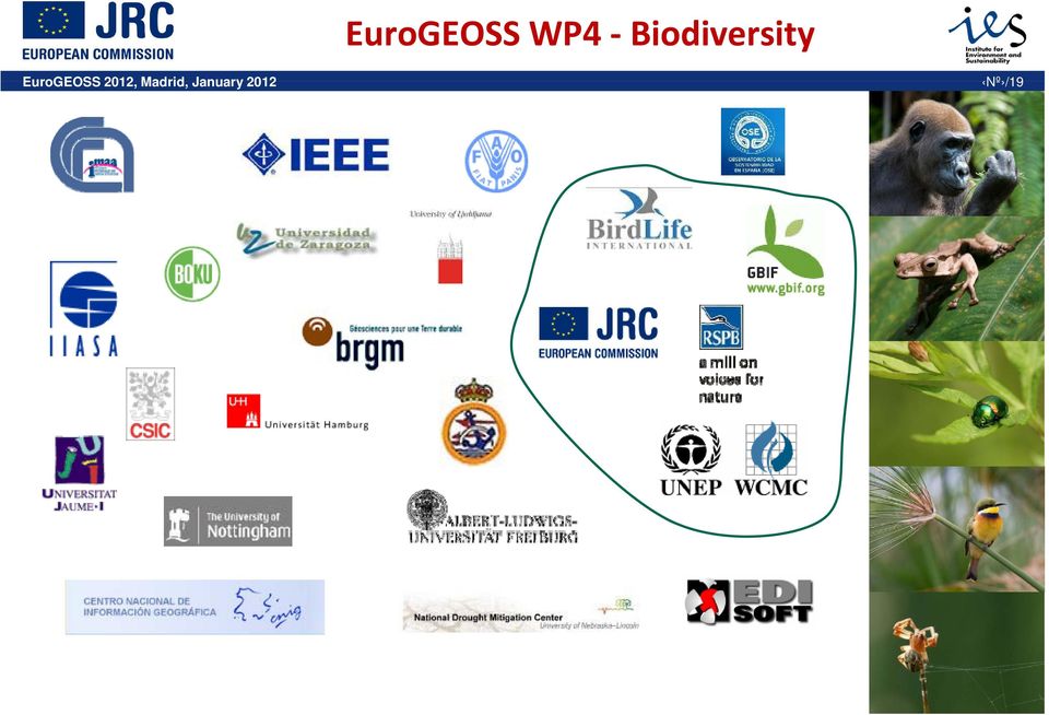
3 EuroGEOSS WP4 Biodiversity
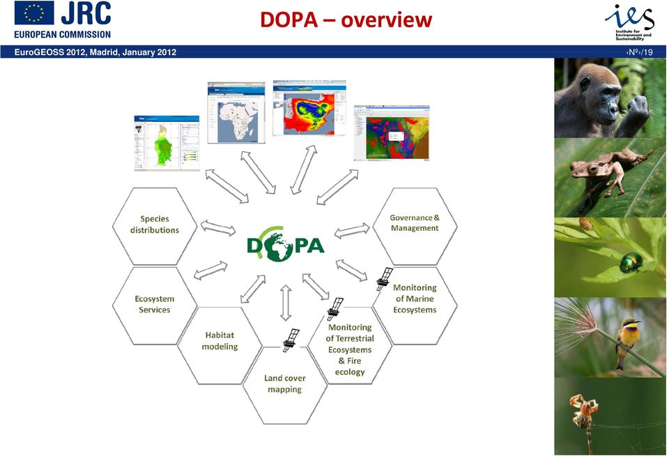
4 DOPA overview Digital Observatory for Protected Areas BIOPAMA DOPA is a set of distributed Web Services to Assess, Monitor, and Forecast Biodiversity i at the Global Scale

5 DOPA overview
6 DOPA retrospective The African Protected Areas Assessment Tool (APAAT) The purpose of the APAAT is to provide to decision makers an assessment of the state of African PAs andto prioritize them according to biodiversity values and threats so as to support decision making and fund allocation processes

7 DOPA retrospective The African Protected Areas Assessment Tool (APAAT) one time assessment static not easily reproducible restricted to Africa Reference: Hartley, A., Nelson, A., Mayaux, P. and Grégoire, J M. (2007). The Assessment of African Protected Areas. JRC Scientific and Technical Reports. Office for Official Publications of the European Communities, Luxembourg, EUR EN. 77p.

8 DOPA outlook Global coverage (near) real time modeling and analytics (near) 1 km resolution Protected Areas Habitats Ecological Monitoring i & Forecasting OGC WxS REST Species

9 Architectural concepts DOPA is a set of web services, of different flavours, that are ableto interoperate each discipline operates their specialized services (ehabitat, especies,...), accompanyingweb sites, sampleapplications applications and wikis transport and support documentation and should trigger and channel scientific discussion for each discipline use data provider services (IUCN, GBIF, Birdlife,...), where possible and acknowledge/propagate p g the use of their data in downstream services enable feedback of ground collected data (e.g. species absence in a protected area) use ofopen open standards, specifications andfree andopen source software to guarantee sustainability and secure project border crossing efforts
 use ofopen open standards, specifications andfree andopen source software to guarantee sustainability and secure project border crossing")
10 Component ehabitat Habitat modeling

11 Component ehabitat Similarity/probability modelling capacity accessible thru a web processing service. Main inputs: 1. One: reference or sample geometry (e.g. protected area (PA)), supplied asidof the World Database of Protected Areas (WDPA), Well known text (WKT), geometry URL (WFS GetFeature, KML, GeoJSON,...) 2. Multiple: indicator layers (e.g. Temperature, precipitation,...), supplied as Web Coverage Service URLs or GetRecordByID URLs (e.g. from EuroGEOSS Broker)
), supplied asidof the World Database of Protected Areas (WDPA), Well known text (WKT), geometry")
12 Component ehabitat: 1# use case Forecast climatic similarity of protected areas - Climatic data current and forecast GCM downscaled at - Different resolutions 1km to ~20 km - Climatic variables from Holdridge s lifezones

13 Component ehabitat: 1# use case Protected Area biot, annual precip., PET/Rainfall Nowcast

14 Component ehabitat: 1# use case Protected Area biot, annual precip., PET/Rainfall Forecast

15 Component ehabitat: 2# use case WEB20 Broker GBIF Density WMS + Filter IUCN Species RedList JSON Birdlife Range WMS + Filter GBIF Taxon REST Service

16 Component ehabitat: 2# use case

17 Component ehabitat: 3# use case Discoverable and runable thru EuroGEOSS Broker Sensible question? Reasonible indicators?

18 Component ehabitat: 3# use case Discoverable and runable thru EuroGEOSS Broker Sensible question? Reasonible indicators?

19 Component especies Species distribution
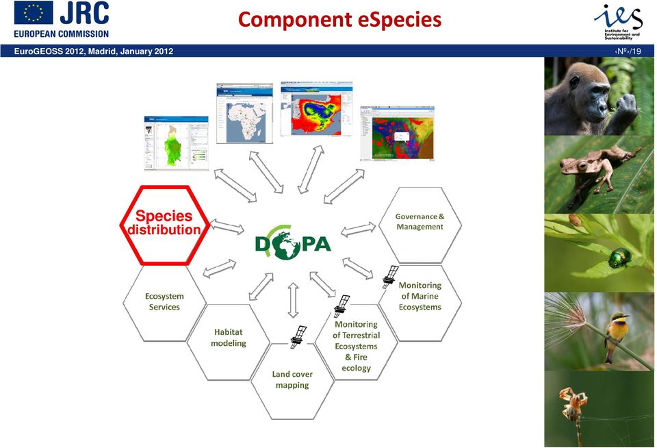
20 Component especies process species data to compute a number of indicators on species compositions, species richness andirreplaceability providing end users with means to give feedback on the presence/absence of species, e.g. in protected areas query species services withvarying premises, like occurrence at a certain point occurrence ina certain PA occurrence in any polygon filter by taxonomy provided as OGC WxS and REST services

21 Component especies: #1 use case
22 Component especies: #2 use case
23 Component especies: #2 use case
24 Component especies: #2 use case
25 Component especies: #2 use case Habitat Replaceability Index (HRI) APAAT currently pre-calculated, with the same algorithm as ehabitat uses, with these indicator layers: Elevation, Slope Cover percentage Tree, Herbaceous, Bare Max. NDVI, NDWI Holdridge variables (BioTemp, Prec, EP ratio)
26 ec europa eu/ Thank you for your attention.
RESPONSE FROM GBIF TO QUESTIONS FOR FURTHER CONSIDERATION
 RESPONSE FROM GBIF TO QUESTIONS FOR FURTHER CONSIDERATION A. Policy support tools and methodologies developed or used under the Convention and their adequacy, impact and obstacles to their uptake, as well
Standardized data sharing through an open-source Spatial Data Infrastructure: the Afromaison project
 Standardized data sharing through an open-source Spatial Data Infrastructure: the Afromaison project Yaniss Guigoz - University of Geneva/GRID-Geneva 1 EcoARM2ERA and AFROMAISON Why Afromaison in this
IBAT (Integrated Biodiversity Assessment Tool)
") IBAT (Integrated Biodiversity Assessment Tool) Martin Sneary, Manager Biodiversity Risk Assessment & Corporate Decision Support (based in Washington DC) Format of session Key sources of biodiversity information
IBAT (Integrated Biodiversity Assessment Tool) Martin Sneary, Manager Biodiversity Risk Assessment & Corporate Decision Support (based in Washington DC) Format of session Key sources of biodiversity information
The Role of Spatial Data in EU Agricultural Policy Analysis
 The Role of Spatial Data in EU Agricultural Policy Analysis Wolfgang Britz Institute for Food and Resource Economics, University Bonn Geospatial Open Source Hosting of Agriculture, Resource and Environmental
Required and Recommended Supporting Information for IUCN Red List Assessments
 Required and Recommended Supporting Information for IUCN Red List Assessments This is Annex 1 of the Rules of Procedure IUCN Red List Assessment Process 2013-2016 as approved by the IUCN SSC Steering Committee
National Inventory of Landscapes in Sweden
 Key messages Approaching the landscape perspective in monitoring experiences in the Swedish NILS program Johan Svensson, Future Forest Monitoring, 091112 Landscape level approaches are necessary to deal
Mapping standards for IUCN Red List assessments
 Mapping standards for IUCN Red List assessments And a few of the exceptions adopted by the Amphibian RLA The IUCN Red List of Threatened Species Purpose of including species maps on the Red List Visual
Environment Canada Data Management Program. Paul Paciorek Corporate Services Branch May 7, 2014
 Environment Canada Data Management Program Paul Paciorek Corporate Services Branch May 7, 2014 EC Data Management Program (ECDMP) consists of 5 foundational, incremental projects which will implement
Global environmental information Examples of EIS Data sets and applications
 METIER Graduate Training Course n 2 Montpellier - february 2007 Information Management in Environmental Sciences Global environmental information Examples of EIS Data sets and applications Global datasets
Processing Biological Data in i-marine
 Processing Biological Data in i-marine Gianpaolo Coro ISTI-CNR i-marine Workshop 14 & 15 May 2013, Bruxelles, Belgium Facilities and Experience - Summary We will show results about: Ecological Niche Modeling
World Data Center for Biodiversity and Ecology - ICSU WDC System. OAS/IABIN Protected Area Meeting January 23, 2007
 World Data Center for Biodiversity and Ecology - ICSU WDC System OAS/IABIN Protected Area Meeting January 23, 2007 WDCBE Partnerships ICSU World Data Center System USGS Host(s) - National Biological Information
Spatial Data Infrastructures - trends and impacts on society. Max Craglia Joint Research Centre Digital Earth and Reference Data Unit
 Spatial Data Infrastructures - trends and impacts on society Max Craglia Joint Research Centre Digital Earth and Reference Data Unit Outline Where we were 20 years ago Where we are now Where we are going
MONITORING OF HABITATS AT THE LEVEL OF A NATURA 2000 SITE MOHANA MOBILE AND WEB APP. Francisco Gutierres 1. May of 2016
 MONITORING OF HABITATS AT THE LEVEL OF A NATURA 2000 SITE MOHANA MOBILE AND WEB APP Francisco Gutierres 1 May of 2016 1 Ph.D. in Physical Geography, Institute of Geography Spatial Planning of the University
Ecosystem perspective on ORs & OCTs
 Workshop on the Application of an Ecosystem Approach for development of Sustainable Aquaculture in Europe s Outermost Regions and Overseas Countries and Territories Session 3: Stakeholders presentations
CDI/THREDDS Interoperability: the SeaDataNet developments. P. Mazzetti 1,2, S. Nativi 1,2, 1. CNR-IMAA; 2. PIN-UNIFI
 CDI/THREDDS Interoperability: the SeaDataNet developments P. Mazzetti 1,2, S. Nativi 1,2, 1. CNR-IMAA; 2. PIN-UNIFI Outline Interoperability Issues in SeaDataNet A broker solution for CDI/THREDDS interoperability
Call for Expressions of Interest: Contributing to the BIOPAMA Regional Observatory for Biodiversity and Protected Areas in West and Central Africa
 Call for Expressions of Interest: Contributing to the BIOPAMA Regional Observatory for Biodiversity and Protected Areas in West and Central Africa A. Overview Protected Areas and Biodiversity Observatory
Distributed Data Management in Internet Map Services
 Distributed Data Management in Internet Map Services Experiences from Lounaispaikka Thematic Atlas Antti Vasanen Regional Council of Southwest Finland Lounaispaikka Lounaispaikka is a regional non-profit
Vector Web Mapping Past, Present and Future. Jing Wang MRF Geosystems Corporation
 Vector Web Mapping Past, Present and Future Jing Wang MRF Geosystems Corporation Oct 27, 2014 Terms Raster and Vector [1] Cells and Pixel Geometrical primitives 2 Early 2000s From static to interactive
The importance of Lebanon for the migratory soaring birds & the flyway. April 2012. Bassima Khatib SPNL Assistant Director General
 The importance of Lebanon for the migratory soaring birds & the flyway April 2012 Bassima Khatib SPNL Assistant Director General Outline Who is SPNL? IBA programme Importance of Lebanon for migratory soaring
GLOBAL CLIMATE MONITOR
 FP7 INCO- 2011 7 INCO- LAB project 294947 https://swanproject.arizona.edu/ GLOBAL CLIMATE MONITOR Natalia Limones ([email protected]) José I. Alvarez ([email protected]) Juan M. Camarillo ([email protected])
African European Georesources Observation System
 African European Georesources Observation System Spatial Data Infrastructure (SDI) Dr. Andreas Barth, Bernd Torchala Beak, Germany Outline Project Overview AEGOS SDI data / services hardware / software
The ORIENTGATE data platform
 Seminar on Proposed and Revised set of indicators June 4-5, 2014 - Belgrade (Serbia) The ORIENTGATE data platform WP2, Action 2.4 Alessandra Nuzzo, Sandro Fiore, Giovanni Aloisio Scientific Computing and
Distributed Computing. Mark Govett Global Systems Division
 Distributed Computing Mark Govett Global Systems Division Modeling Activities Prediction & Research Weather forecasts, climate prediction, earth system science Observing Systems Denial experiments Observing
Nature Values Screening Using Object-Based Image Analysis of Very High Resolution Remote Sensing Data
 Nature Values Screening Using Object-Based Image Analysis of Very High Resolution Remote Sensing Data Aleksi Räsänen*, Anssi Lensu, Markku Kuitunen Environmental Science and Technology Dept. of Biological
Best Practice Network for SDI Nature Conservation TECHNOLOGICAL ASPECTS
 Best Practice Network for SDI Nature Conservation TECHNOLOGICAL ASPECTS Authors: Giorgio Saio, Carmelo Attardo Maria Cabello Giacomo Martirano Andrea Fiduccia, Stefano Turcato, Alina Kmiecik Monica De
The Role of Resource Assessment in Scaling Up Renewable Energy
 The Role of Resource Assessment in Scaling Up Renewable Energy Charging Ahead: Scaling Up Renewable Energy in the Developing World Nisha Thirumurthy October 27, 2015 NREL is a national laboratory of the
Monitoring for Conservation Planning and Management. Environmental Evaluators Forum EPA Headquarters, USA June 14 15, 2007
 Monitoring for Conservation Planning and Management Environmental Evaluators Forum EPA Headquarters, USA June 14 15, 2007 Key Types of Decisions Prioritization (where Status to allocate scarce conservation
Description and Testing of the Geo Data Portal: A Data Integration Framework and Web Processing Services for Environmental Science Collaboration
 Description and Testing of the Geo Data Portal: A Data Integration Framework and Web Processing Services for Environmental Science Collaboration Open-File Report 2011 1157 U.S. Department of the Interior
Assessing risks to ecosystems - a new global standard
 Assessing risks to ecosystems - a new global standard IUCN Ecosystem Red List Working Group David Keith et al. Major scientific challenges I. What is an ecosystem? II. When is an ecosystem extinct? disappearance
Mobilising Vegetation Plot Data: the National Vegetation Survey Databank. Susan Wiser April 2016 http://nvs.landcareresearch.co.nz
 Mobilising Vegetation Plot Data: the National Vegetation Survey Databank Susan Wiser April 2016 http://nvs.landcareresearch.co.nz Nationally Significant Databases and Collections http://natsigdc.landcareresearch.co.nz/natsigdc_list.html
Enabling embedded maps
 Enabling embedded maps Case: National geoportal of Finland Antti Rainio National Land Survey of Finland Trends: Web Services, Mapping Mashup, Open Source, Open Data Decentralised data s Service interfaces
How To Manage Protected Areas
 ECHOES FROM BARILOCHE: Conclusions, Recommendations and Action Guidelines The Second Latin American Congress on National Parks and other Protected Areas aimed to asses, value and project the contribution
Development of the open cadastre of protected areas in Ukraine
 Development of the open cadastre of protected areas in Ukraine Daria Svidzinska1, Oleksij Vasyliuk2, 3, Oleg Seliverstov4, Daria Shyriaieva1, 3, Anton Biatov5, 3, Dmytro Diadin7, Alevtyna Ponomarova4,
Week 7 - Geographic Analysis of Living Species
 G563 Quantitative Paleontology Department of Geological Sciences P. David Polly Week 7 - Geographic Analysis of Living Species The goal of this week s assignment is to learn to process geographic range
DATA FOR BIODIVERSITY SCENARIOS AND RELATED QUESTIONS IN WEST AFRICA
 Université NANGUI ABROGOUA West African Science Service Center on Climate Change and Adapted Land Use DATA FOR BIODIVERSITY SCENARIOS AND RELATED QUESTIONS IN WEST AFRICA Prof. Souleymane Konaté University
7th Framework Programme Theme 6 Environment (including climate change)
") 7th Framework Programme Theme 6 Environment (including climate change) «Environnement» et «Énergie» Programme D. Deybe DG RTD Environment Directorate 1 Cooperation Collaborative Research Ten themes 1.
7th Framework Programme Theme 6 Environment (including climate change) «Environnement» et «Énergie» Programme D. Deybe DG RTD Environment Directorate 1 Cooperation Collaborative Research Ten themes 1.
Quality Assessment for Geographic Web Services. Pedro Medeiros (1)
") Quality Assessment for Geographic Web Services Pedro Medeiros (1) (1) IST / INESC-ID, Av. Prof. Dr. Aníbal Cavaco Silva, 2744-016 Porto Salvo, [email protected] Abstract Being able to assess the
Quality Assessment for Geographic Web Services Pedro Medeiros (1) (1) IST / INESC-ID, Av. Prof. Dr. Aníbal Cavaco Silva, 2744-016 Porto Salvo, [email protected] Abstract Being able to assess the
European Soil Data Centre (ESDAC) Marc Van Liedekerke Land Management and Natural Harzards Unit
 Marc Van Liedekerke Land Management and Natural Harzards Unit") European Soil Data Centre (ESDAC) Marc Van Liedekerke Land Management and Natural Harzards Unit 1 Outline 1. What is ESDAC? 2. Requirements 3. Information providers; Inventory 4. ESDAC Repository 5. Implementation
European Soil Data Centre (ESDAC) Marc Van Liedekerke Land Management and Natural Harzards Unit 1 Outline 1. What is ESDAC? 2. Requirements 3. Information providers; Inventory 4. ESDAC Repository 5. Implementation
Cloud-based Geospatial Data services and analysis
 Cloud-based Geospatial Data services and analysis Xuezhi Wang Scientific Data Center Computer Network Information Center Chinese Academy of Sciences 2014-08-25 Outlines 1 Introduction of Geospatial Data
Greening REDD+ Challenges and opportunities for forest biodiversity conservation. Workshop summary
 Greening REDD+ Challenges and opportunities for forest biodiversity conservation Workshop summary D. Benick 1 *, S. Entenmann 2 *, T. Pistorius 1, C.B. Schmitt 2 1 Institute of Forest and Environmental
GARP. Genetic Algorithm for Rule-Set Prediction:
 GARP Genetic Algorithm for Rule-Set Prediction: machine-learning algorithm that creates ecological niche models for a species (Chen and Peterson 2000; Peterson 2001; Stockwell 1999). ecological niche of
Open Source Visualisation with ADAGUC Web Map Services
 Open Source Visualisation with ADAGUC Web Map Services Maarten Plieger Ernst de Vreede John van de Vegte, Wim Som de Cerff, Raymond Sluiter, Ian van der Neut, Jan Willem Noteboom 1 ADAGUC project Cooperative
The USGS Landsat Big Data Challenge
 The USGS Landsat Big Data Challenge Brian Sauer Engineering and Development USGS EROS [email protected] U.S. Department of the Interior U.S. Geological Survey USGS EROS and Landsat 2 Data Utility and Exploitation
 Mesoscale re-analysis of historical meteorological data over Europe Anna Jansson and Christer Persson, SMHI ERAMESAN A first attempt at SMHI for re-analyses of temperature, precipitation and wind over
DISMAR implementing an OpenGIS compliant Marine Information Management System
 DISMAR implementing an OpenGIS compliant Marine Information Management System Éamonn Ó T uama, Coastal & Marine Resources Centre, ERI, University College Cork. DISMAR DISMAR (Data Integration System for
Vulnerability Assessment of New England Streams: Developing a Monitoring Network to Detect Climate Change Effects
 Vulnerability Assessment of New England Streams: Developing a Monitoring Network to Detect Climate Change Effects National Water Quality Monitoring Council 2012 Meeting Britta Bierwagen, National Center
Note on Draft Progress Report Template
 Note on Draft Progress Report Template The Draft Progress Report template is provided as a guide to applicants on possible reporting requirements for the Biodiversity Fund. This actual report will be provided
JOINT RESEARCH CENTER. European Forest Data Center (EFDAC)
") Institute for Environment and Sustainability 1 JOINT RESEARCH CENTER European Forest Data Center (EFDAC) Gerimantas Gaigalas [email protected] BACKGROUND Institute for Environment and Sustainability
Institute for Environment and Sustainability 1 JOINT RESEARCH CENTER European Forest Data Center (EFDAC) Gerimantas Gaigalas [email protected] BACKGROUND Institute for Environment and Sustainability
Data interchange between Web client based task controllers and management information systems using ISO and OGC standards
 Data interchange between Web client based task controllers and management information systems using ISO and OGC standards Michael Nørremark 1*, Ole Jørgensen 1, Jens Bligaard 2 and Claus G. Sørensen 1
1.7.0 Floodplain Modification Criteria
 1.7.0 Floodplain Modification Criteria 1.7.1 Introduction These guidelines set out standards for evaluating and processing proposed modifications of the 100- year floodplain with the following objectives:
Leveraging Cloud-Based Mapping Solutions
 Leveraging Cloud-Based Mapping Solutions GeoAlberta October 28, 2014 Laura Kerssens Safe Software Agenda To the Cloud Using Basic Services Cloud Applications Web Services Cloud-Hosted Databases Real-time
Koen Verbist UNESCO International Hydrological Programme
 Koen Verbist UNESCO International Hydrological Programme Climate Risk Management Development of a Climate Risk Management system for the region, based on three pillars: 1. Identify Vulnerabilities and
CentropeSTATISTICS a Tool for Cross-Border Data Presentation Manfred Schrenk, Clemens Beyer, Norbert Ströbinger
 Manfred Schrenk, Clemens Beyer, Norbert Ströbinger (Dipl.-Ing. Manfred Schrenk, Multimediaplan.at, 2320 Schwechat, Austria, [email protected]) (Dipl.-Ing. Clemens Beyer, CORP Competence Center
CRMS Website Training March 2015
 CRMS Website Training March 2015 http://www.lacoast.gov/crms CWPPRA Restoration Program CWPPRA was congressionally funded in 1990 and mandated 20 years of restoration project monitoring CWPPRA program
Open data. Noordzeedagen. Gerard van der Kolff
 Open data Noordzeedagen Gerard van der Kolff Data growth and -storage, what s new? Predicting the future is difficult... ...and mostly fails. The Digital Disruption has already happened Worlds largest
Interactions between rodent borne diseases and climate, and the risks for public and animal health
 Interactions between rodent borne diseases and climate, and the risks for public and animal health Mare Lõhmus Climate centrum / SMS / KMF National Veterinary Institute Uppsala, Sweden The source of many
observation: the future Professor Ian Boyd, Chief Scientific Adviser, Defra
 Biodiversity and earth observation: the future for big data in the UK Professor Ian Boyd, Chief Scientific Adviser, Defra Introduction: Structure of presentation 1. Defra-network priorities iti for biodiversity
CRMS Website Training
 CRMS Website Training March 2013 http://www.lacoast.gov/crms Coastwide Reference Monitoring System - Wetlands CWPPRA Restoration Projects Congressionally funded in 1990 Multiple restoration techniques
GOSIC NEXRAD NIDIS NOMADS
 NOAA National Climatic Data Center GOSIC NEXRAD NIDIS NOMADS Christina Lief NOAA/NESDIS/NCDC GOSIC Program Manager NOAA/NESDIS/NCDC Asheville, NC 28801 GEOSS AIP Phase 2 Workshop September 25-26, 2008
Geospatial exploitation Products. GXP WebView. Powered by the GXP Platform
 Geospatial exploitation Products GXP WebView Powered by the GXP Platform Exploitation Capabilities GXP WebView Powered by the GXP Platform Detailed annotation (text, points, lines, and polygons) Distance,
Red-listed plants in semi-natural landscapes
 Red-listed plants in semi-natural landscapes Esgo Kuiper & Anders Bryn Norwegian Forest and Landscape Institute, PO Box 115, Raveien 9, NO-1431 Aas, Norway. Phone: +47 64948000, e-mail: [email protected]
San Francisco Bay Margin Conservation Decision Support System (DSS)
") San Francisco Bay Margin Conservation Decision Support System (DSS) Presented by Brian Fulfrost1, MS David Thomson2, MS 1 Brian Fulfrost and Associates 2 San Francisco Bay Bird Observatory Transitional
San Francisco Bay Margin Conservation Decision Support System (DSS) Presented by Brian Fulfrost1, MS David Thomson2, MS 1 Brian Fulfrost and Associates 2 San Francisco Bay Bird Observatory Transitional
ArcGIS Framework Plug-In: Extending the ArcGIS Desktop for ANSI Standard Framework Data to Support Government Decision Making
 ArcGIS Framework Plug-In: Extending the ArcGIS Desktop for ANSI Standard Framework Data to Support Government Decision Making Final Project Report October 28, 2008 Agreement Number Organization Project
The Biodiversity Information System for Europe - BISE -
 The Biodiversity Information System for Europe - BISE - Sabine Roscher Dominique Richard European Topic Centre Biological Diversity (ETC/BD) Meeting of the Group of experts on Protected Areas and ecological
Oklahoma s Open Source Spatial Data Clearinghouse: OKMaps
 Oklahoma s Open Source Spatial Data Clearinghouse: OKMaps Presented by: Mike Sharp State Geographic Information Coordinator Oklahoma Office of Geographic Information MAGIC 2014 Symposium April 28-May1,
GeoNetwork, The Open Source Solution for the interoperable management of geospatial metadata
 GeoNetwork, The Open Source Solution for the interoperable management of geospatial metadata Ing. Emanuele Tajariol, GeoSolutions Ing. Simone Giannecchini, GeoSolutions GeoSolutions GeoSolutions GeoNetwork
Piping Plover Distribution Modeling
 Piping Plover Distribution Modeling Scientific Name: Charadrius melodus Distribution Status: Migratory Summer Breeder State Rank: S2B Global Rank: G3 Inductive Modeling Model Created By: Joy Ritter Model
Choosing the right GIS framework for an informed Enterprise Web GIS Solution
 13 ANNUAL INTERNATIONAL CONFERENCE AND EXHIBITION ON GEOSPATIAL INFORMATION TECHNOLOGY AND APPLICATIONS Epicentre; Gurgaon, India; 19-21 January, 2010 Choosing the right GIS framework for an informed Enterprise
The importance of biodiversity monitoring
 The importance of biodiversity monitoring Sebastian Winkler IUCN Save Biodiversity! Regional Office for Europe 18 June 2009, London The 2010 Biodiversity Target: There are limits is hard to measure fails
Black Tern Distribution Modeling
 Black Tern Distribution Modeling Scientific Name: Chlidonias niger Distribution Status: Migratory Summer Breeder State Rank: S3B Global Rank: G4 Inductive Modeling Model Created By: Joy Ritter Model Creation
Monitoring the Critically Endangered Bird Species (White-shouldered Ibis) in Western Siem Pang Important Bird and Biodiversity Area (IBA)
 in Western Siem Pang Important Bird and Biodiversity Area (IBA)") Monitoring the Critically Endangered Bird Species (White-shouldered Ibis) in Western Siem Pang Important Bird and Biodiversity Area (IBA) Transboundary Biodiversity Landscapes (TBLs) Knowledge Meeting
Monitoring the Critically Endangered Bird Species (White-shouldered Ibis) in Western Siem Pang Important Bird and Biodiversity Area (IBA) Transboundary Biodiversity Landscapes (TBLs) Knowledge Meeting
Linking Sensor Web Enablement and Web Processing Technology for Health-Environment Studies
 Linking Sensor Web Enablement and Web Processing Technology for Health-Environment Studies Simon Jirka 1, Stefan Wiemann 2, Johannes Brauner 2, and Eike Hinderk Jürrens 1 1 52 North Initiative for Geospatial
NetCDF and HDF Data in ArcGIS
 2013 Esri International User Conference July 8 12, 2013 San Diego, California Technical Workshop NetCDF and HDF Data in ArcGIS Nawajish Noman Kevin Butler Esri UC2013. Technical Workshop. Outline NetCDF
Armenian State Hydrometeorological and Monitoring Service
 Armenian State Hydrometeorological and Monitoring Service Offenbach 1 Armenia: IN BRIEF Armenia is located in Southern Caucasus region, bordering with Iran, Azerbaijan, Georgia and Turkey. The total territory
Nowcasting: analysis and up to 6 hours forecast
 Nowcasting: analysis and up to 6 hours forecast Very high resoultion in time and space Better than NWP Rapid update Application oriented NWP problems for 0 6 forecast: Incomplete physics Resolution space
A Web Service based U.S. Cropland Visualization, Dissemination and Querying System
 A Web Service based U.S. Cropland Visualization, Dissemination and Querying System Rick Mueller, Zhengwei Yang, and Dave Johnson USDA/National Agricultural Statistics Service Weiguo Han and Liping Di GMU/Center
Protected Areas Resilient to Climate Change, PARCC West Africa
 Communication Strategy (PARCC Activity 4.2) Ver. 1. Protected Areas Resilient to Climate Change, PARCC West Africa 2011 Rapid Screening of Vulnerability Assessment Tools and Framework Proposal Executive