Choosing the right GIS framework for an informed Enterprise Web GIS Solution
|
|
|
- Anthony Haynes
- 10 years ago
- Views:
Transcription
1 13 ANNUAL INTERNATIONAL CONFERENCE AND EXHIBITION ON GEOSPATIAL INFORMATION TECHNOLOGY AND APPLICATIONS Epicentre; Gurgaon, India; January, 2010 Choosing the right GIS framework for an informed Enterprise Web GIS Solution Presented By Sneha Rao, Gurgaon, India. Jan 20, 2010 Co-authored By Sri Vinay,

2 Web GIS and its importance Web GIS is the obvious graduation of GIS on a distributed environment through a simple browser Enables organizations to share domain-specific rich and dynamic spatial information over the web Web GIS finds applications in a wide-range of internet based applications such as environmental sustainability indicators, global population predictions, water sustainability, hazard vulnerabilities, climate and disaster monitoring, education, banking, armed forces etc. Few examples of CIESIN Web GIS client applications:

3 Enterprise Web GIS framework An enterprise Web GIS framework applies a geographic approach for better decision making by comparison of existing spatial data sets with legacy and other existing sources. It is thus extremely important to understand the complexity of the Web GIS components and the various interactions and relationships between them when designing an enterprise solution Here below is a broad outline of design considerations: Architecture System Components Factors affecting system components Usability improvement Application of system

4 Multi-tier generic Client-server Web GIS Architecture

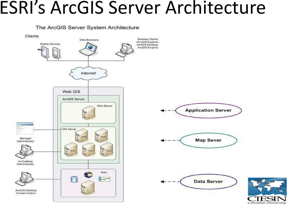
5 ESRI s ArcGIS Server Architecture
6 GeoServer Architecture

7 CIESIN s Enterprise Web GIS Architecture Implementation

8 Factors affecting Web GIS System Components Various factors affecting the overall system performance and responsiveness: Workflow Server performance Maintenance and Backward Compatibility Scalability Interoperability Data formats for publishing Total Cost of ownership Customization Network Bandwidth Capabilities

9 Server Performance: Response time: Thick v/s Thin Applications

10 Server Performance: Heap Memory Use of ArcGIS ADF Application Server

11 Server Performance: ArcGIS Server SOC v/s CPU Load

12 Server Performance: ArcGIS Server Rest v/s WMS service performance

13 Server Performance: WMS Service Performance: ArcGIS Server and GeoServer

14 Interoperability Service Capabilities ArcServer Geoserver 2.0 WCS compliant Fully compliant to WCS 1.0, 1.1 and Fully compliant with WCS 1.0 and 1.1 WFS compliant Fully compliant to WFS 1.0 and 1.1 (transactions) Fully compliant to WFS 1.0 and 1.1 (transactions and locking) WMS compliant Fully compliant to WMS and 1.3 Fully compliant to WMS Web map Output As JPEG, GIF, PNG, PDF, SVG, KML and GeoRSS As JPEG, GIF, PNG, PDF, SVG, KML and GeoRSS Projection on demand Geometry service enables sophisticated projection operations on applications that do not have the ability to perform such operations independently On the fly reprojection for WMS and WFS from a pool of hundreds of supported EPSG projections stored in a database SLD compliant Fully compliant to SLD 1.0 Full SLD support, to support map styles Filter encoding Fully compliant to Filter Encoding 1.0 and 1.1 Full Filter support on all data formats in WFS

15 Data Publishing Formats Service Data publishing format ArcServer Geoserver 2.0 Vector Data Map document (*.mxd) and Map service definition (*.msd) Shapefile - ESRI(tm) Shapefiles (*.shp) and directory of spatial files stored as a datastore Raster Data Raster dataset (from a geo-databases or file on disk), GeoTiff, BIL or layer file referencing a raster dataset or compiled image service definition (containing one or more raster datasets and defined processes) ArcGrid (coverage format), GeoTiff (Tagged Image File Format with Geographic information), Gtopo30 (coverage format), ImageMosaic (Image mosaicking plugin), WorldImage (raster file with a spatial data file) and Image pyramids Spatial database Database connection file (*.sde), personal and file geo-databases, map document referencing data from a versioned geodatabase PostGIS compliant with OpenGIS Simple Features Interface Standard (SFS), ArcSDE (*.sde), DB2 and Oracle Processing Tool Support for geoprocessing map document with a tool layer or toolbox (*.tbx) Not supported
, WorldImage (raster file with a spatial data file) and Image pyramids Spatial database Database connection file (*.")
16 Factors affecting usability experience of a Web GIS system Besides the functional components that affect the hardware and software decisions when designing an enterprise Web GIS solution. There are some important factors that affect the usability experience of a system: Thinner services with appropriate symbology Cached Layers Aggregating and Clustering Large Datasets

17 CONCLUSION Thanks Q & A?????

Choosing the right GIS framework for an informed Enterprise Web GIS Solution
 Choosing the right GIS framework for an informed Enterprise Web GIS Solution Written By Sneha Rao ([email protected]) and Sri Vinay ([email protected]) CIESIN, Columbia University & NASA New
The ORIENTGATE data platform
 Seminar on Proposed and Revised set of indicators June 4-5, 2014 - Belgrade (Serbia) The ORIENTGATE data platform WP2, Action 2.4 Alessandra Nuzzo, Sandro Fiore, Giovanni Aloisio Scientific Computing and
INTEROPERABLE IMAGE DATA ACCESS THROUGH ARCGIS SERVER
 INTEROPERABLE IMAGE DATA ACCESS THROUGH ARCGIS SERVER Qian Liu Environmental Systems Research Institute 380 New York Street Redlands, CA92373, U.S.A - [email protected] KEY WORDS: OGC, Standard, Interoperability,
Chapter 1: Introduction to ArcGIS Server
 Chapter 1: Introduction to ArcGIS Server At a high level you can think of ArcGIS Server as software that helps you take your geographic information and make it available to others. This data can be distributed
ArcGIS Server Implementation HIGHS and lows
 ArcGIS Server Implementation HIGHS and lows GIS-T March 2011 Eric Abrams Iowa DOT [email protected] Agenda The Problem Timeline Future Discussion/Questions The Problem - 2006 How does Iowa DOT integrate
Pennsylvania Geospatial Data Sharing Standards (PGDSS) V 2.5
 V 2.5") Submitted to: Pennsylvania Geospatial Data Sharing Standards (PGDSS) V 2.5 Spatial Data Migration Tools Report May 2, 2007 Table of Contents 1.0 Document Purpose...B-1 2.0 Overview of Spatial Data Migration
Submitted to: Pennsylvania Geospatial Data Sharing Standards (PGDSS) V 2.5 Spatial Data Migration Tools Report May 2, 2007 Table of Contents 1.0 Document Purpose...B-1 2.0 Overview of Spatial Data Migration
GIS Databases With focused on ArcSDE
 Linköpings universitet / IDA / Div. for human-centered systems GIS Databases With focused on ArcSDE Imad Abugessaisa [email protected] 20071004 1 GIS and SDBMS Geographical data is spatial data whose
Oklahoma s Open Source Spatial Data Clearinghouse: OKMaps
 Oklahoma s Open Source Spatial Data Clearinghouse: OKMaps Presented by: Mike Sharp State Geographic Information Coordinator Oklahoma Office of Geographic Information MAGIC 2014 Symposium April 28-May1,
Standardized data sharing through an open-source Spatial Data Infrastructure: the Afromaison project
 Standardized data sharing through an open-source Spatial Data Infrastructure: the Afromaison project Yaniss Guigoz - University of Geneva/GRID-Geneva 1 EcoARM2ERA and AFROMAISON Why Afromaison in this
UK Location Programme
 Location Information Interoperability Board Data Publisher How To Guide Understand the background to establishing an INSPIRE View Service using GeoServer DOCUMENT CONTROL Change Summary Version Date Author/Editor
SuperGIS Server 3.2 Standard Edition Specification
 SuperGIS Server 3.2 Standard Edition Specification 20140826 Specification 1. All of the services support SOAP (Simple Object Access Protocol). 2. Use map file created by SuperGIS Desktop as map services
Enterprise GIS Solutions to GIS Data Dissemination
 Enterprise GIS Solutions to GIS Data Dissemination ESRI International User Conference July 13 17, 2009 Wendy M. Turner Senior GIS Engineer & Program Manager Freedom Consulting Group, LLC Building the Enterprise
ArcGIS for Server Performance and Scalability-Testing and Monitoring Tools. Amr Wahba [email protected]
 ArcGIS for Server Performance and Scalability-Testing and Monitoring Tools Amr Wahba [email protected] Introductions Who are we? - ESRI Dubai Office Target audience - GIS administrators - DBAs - Architects
GeoServer, The Open Source Solution for the interoperable management of geospatial data
 GeoServer, The Open Source Solution for the interoperable management of geospatial data Ing. Andrea Aime, GeoSolutions Ing. Simone Giannecchini, GeoSolutions Founded in Italy in late 2006 Expertise GeoSolutions
ArcGIS. Server. A Complete and Integrated Server GIS
 ArcGIS Server A Complete and Integrated Server GIS ArcGIS Server A Complete and Integrated Server GIS ArcGIS Server enables you to distribute maps, models, and tools to others within your organization
MrSID Plug-in for 3D Analyst
 LizardTech MrSID Plug-in for 3D Analyst User Manual Copyrights Copyright 2009 2010 LizardTech. All rights reserved. Information in this document is subject to change without notice. The software described
Big Data Volume & velocity data management with ERDAS APOLLO. Alain Kabamba Hexagon Geospatial
 Big Data Volume & velocity data management with ERDAS APOLLO Alain Kabamba Hexagon Geospatial Intergraph is Part of the Hexagon Family Hexagon is dedicated to delivering actionable information through
A Hybrid Architecture for Mobile Geographical Data Acquisition and Validation Systems
 A Hybrid Architecture for Mobile Geographical Data Acquisition and Validation Systems Claudio Henrique Bogossian 1, Karine Reis Ferreira 1, Antônio Miguel Vieira Monteiro 1, Lúbia Vinhas 1 1 DPI Instituto
Web and Mobile GIS Applications Development
 Web and Mobile GIS Applications Development Presented by : Aamir Ali Manager Section Head (GIS Software Customization) Pakistan Space and Upper Atmosphere Research Commission (SUPARCO) Geographical Information
GIS AS A DECISION SUPPORT FOR SUPPLY CHAIN MANAGEMENT
 Paper Reference No.: PN-253 GIS AS A DECISION SUPPORT FOR SUPPLY CHAIN MANAGEMENT Sanjay Kumar 1 and Suneeta Agrawal 2 1. M. Tech. (GIS & Remote Sensing); GIS Cell; MNNIT, Allahabad, India (E-mail: [email protected])
VISUAL INSPECTION OF EO DATA AND PRODUCTS - OVERVIEW
 WMS services from the EUMETSAT real-time Image Gallery Uwe Voges (1), Michael Schick (2), Udo Einspanier (1) (1) con terra GmbH Martin-Luther-King-Weg 24, 48155, Münster, Germany EMail: (U.Voges U.Einspanier)@conterra.de
Web Map Service Architecture for Topographic Data in Finland
 Web Map Service Architecture for Topographic Data in Finland Teemu Sipilä National Land Survey of Finland Abstract. Since 2012 National Land Survey of Finland has been renewing its web map services and
GeoMedia Product Update. Title of Presentation. Lorilie Barteski October 15, 2008 Edmonton, AB
 Product Update Title of Presentation Lorilie Barteski Edmonton, AB Know the audience poll Existing /Pro users Version 6.1 Version 6.0 Version 5.2 or earlier Existing WebMap users Version 6.1 Version 6.0
ArcGIS Framework Plug-In: Extending the ArcGIS Desktop for ANSI Standard Framework Data to Support Government Decision Making
 ArcGIS Framework Plug-In: Extending the ArcGIS Desktop for ANSI Standard Framework Data to Support Government Decision Making Final Project Report October 28, 2008 Agreement Number Organization Project
An Esri White Paper August 2009 ArcGIS Server in Practice Series High-Capacity Map Services: A Use Case with CORINE Land-Cover Data
 An Esri White Paper August 2009 ArcGIS Server in Practice Series High-Capacity Map Services: A Use Case with CORINE Land-Cover Data Esri, 380 New York St., Redlands, CA 92373-8100 USA TEL 909-793-2853
ArcGIS Server in Practice Series: Best Practices for Creating an ArcGIS Server Web Mapping Application for Municipal/Local Government
 An Esri White Paper August 2009 ArcGIS Server in Practice Series: Esri, 380 New York St., Redlands, CA 92373-8100 USA TEL 909-793-2853 FAX 909-793-5953 E-MAIL [email protected] WEB www.esri.com Copyright 2009
ArcGIS for Server Performance and Scalability: Testing Methodologies. Andrew Sakowicz, [email protected] Frank Pizzi, fpizzi@esri.
 ArcGIS for Server Performance and Scalability: Testing Methodologies Andrew Sakowicz, [email protected] Frank Pizzi, [email protected] Introductions Target audience - GIS, DB, System administrators - Testers
Institute of Computational Modeling SB RAS
 Institute of Computational Modeling SB RAS ORGANIZATION OF ACCESS TO OBSERVATIONAL DATA USING WEB SERVICES FOR MONITORING SYSTEMS THE STATE OF THE ENVIRONMENT Kadochnikov Aleksey A. Russia, Krasnoyarsk
Interoperable Solutions in Web-based Mapping
 ISPRS SIPT IGU UCI CIG ACSG Table of contents Table des matières Authors index Index des auteurs Search Recherches Exit Sortir Interoperable Solutions in Web-based Mapping Marta Wojnarowska and Bridget
Five Steps to Better Performance
 Effective Web maps have a specific focus and are designed so users can interact with them to accomplish meaningful tasks. Five Steps to Better Performance Sample methodology for creating a great Web map
Publishing KML Services Tutorial
 Publishing KML Services Tutorial Copyright 1995-2010 Esri All rights reserved. Table of Contents Tutorial: Publishing a KML service............................ 3 Copyright 1995-2010 ESRI, Inc. All rights
GeoManitoba Spatial Data Infrastructure Update. Presented by: Jim Aberdeen Shawn Cruise
 GeoManitoba Spatial Data Infrastructure Update Presented by: Jim Aberdeen Shawn Cruise Organization Overview Manitoba Innovation Energy and Mines Business Transformation and Technology (BTT) Application
Creating Service Definition file while disconnected from the server
 Service Definition File Creating Service Definition file while disconnected from the server When disconnected from the server you will configure your service definition with no available connection to
Implementation of information system to respond to a nuclear emergency affecting agriculture and food products - Case of Morocco
 Centre National de l énergie des sciences et techniques nucléaires (CNESTEN-Morocco) Implementation of information system to respond to a nuclear emergency affecting agriculture and food products - Case
Performance and Scalability Best Practices in ArcGIS
 2013 Europe, Middle East, and Africa User Conference October 23-25, 2013 Munich, Germany Performance and Scalability Best Practices in ArcGIS Andrew Sakowicz [email protected] Introductions Target audience
13/10/2011. Data Integration and Interoperability. Gordon Sumerling & Maree Wilson
 Data Integration and Interoperability Gordon Sumerling & Maree Wilson 1 Agenda Seamless integration between GIS and CAD CAD Support in ArcGIS Using GIS Data in CAD Editing GIS Data in CAD Introduction
Data Integration for ArcGIS Users Data Interoperability. Charmel Menzel, ESRI Don Murray, Safe Software
 Data Integration for ArcGIS Users Data Interoperability Charmel Menzel, ESRI Don Murray, Safe Software Product overview Extension to ArcGIS (optional) Jointly developed with Safe Software Based on Feature
Spatial data models (types) Not taught yet
 Not taught yet") Spatial data models (types) Not taught yet A new data model in ArcGIS Geodatabase data model Use a relational database that stores geographic data A type of database in which the data is organized across
Spatial data models (types) Not taught yet A new data model in ArcGIS Geodatabase data model Use a relational database that stores geographic data A type of database in which the data is organized across
Leveraging Geospatial Information Across the Enterprise: Bentley s Flexible Geospatial Approach
 Leveraging Geospatial Information Across the Enterprise: Bentley s Flexible Geospatial Approach A Bentley White Paper Gijsbert Noordam Product Manager Nicolas Loubier Senior Product Manager July 2012 www.bentley.com
Enterprise Architectures for Large Tiled Basemap Projects. Tommy Fauvell
 Enterprise Architectures for Large Tiled Basemap Projects Tommy Fauvell Tommy Fauvell Senior Technical Analyst Esri Professional Services Washington D.C Regional Office Project Technical Lead: - Responsible
Using CAD Data in ArcGIS
 Esri International User Conference San Diego, California Technical Workshops July 27, 2012 Using CAD Data in ArcGIS Jeff Reinhart & Phil Sanchez Agenda Overview of ArcGIS CAD Support Using CAD Datasets
Leveraging Geospatial Information Across the Enterprise: Bentley s Flexible Geospatial Approach
 Leveraging Geospatial Information Across the Enterprise: Bentley s Flexible Geospatial Approach A Bentley White Paper Gijsbert Noordam Senior Consultant, Geospatial Center of Excellence www.bentley.com
ArcGIS Server Best Practices and Guidelines
 ArcGIS Server Best Practices and Guidelines NEARC 2007 ESRI Technical Session ESRI, Boston Agenda Components and Deployment OS User Groups and Directory Configuration Service Architectures GIS Security
ESRI Technical Certification Overview. Amy Daniels Instructor, Greenville Tech
 ESRI Technical Certification Overview Amy Daniels Instructor, Greenville Tech Why have certification by ESRI? It communicates your proficiency in ESRI software Similar to Microsoft Certification, it can
Chapter 6: Data Acquisition Methods, Procedures, and Issues
 Chapter 6: Data Acquisition Methods, Procedures, and Issues In this Exercise: Data Acquisition Downloading Geographic Data Accessing Data Via Web Map Service Using Data from a Text File or Spreadsheet
AN OPENGIS WEB MAP SERVER FOR THE ESA MULTI-MISSION CATALOGUE
 AN OPENGIS WEB MAP SERVER FOR THE ESA MULTI-MISSION CATALOGUE T. Westin a, *, C. Caspar b, L. Edgardh a, L. Schylberg c a Spacemetric AB, Tingsv 19, 19161 Sollentuna, Sweden - [email protected] b ESA Esrin,
DEVELOPMENT AND COMPARISON OF OPEN SOURCE BASED WEB GIS FRAMEWORKS ON WAMP AND APACHE TOMCAT WEB SERVERS
 DEVELOPMENT AND COMPARISON OF OPEN SOURCE BASED WEB GIS FRAMEWORKS ON WAMP AND APACHE TOMCAT WEB SERVERS Sonam Agrawal a, Rajan Dev Gupta b a GIS Cell, Motilal Nehru National Institute of Technology, Allahabad-211004,
ArcGIS Server Performance and Scalability Optimization and Testing. Andrew Sakowicz
 ArcGIS Server Performance and Scalability Optimization and Testing Andrew Sakowicz Objective Overview: - Key performance factors - Optimization techniques - Performance Testing Introduction Andrew Sakowicz
GEOG 482/582 : GIS Data Management. Lesson 10: Enterprise GIS Data Management Strategies GEOG 482/582 / My Course / University of Washington
 GEOG 482/582 : GIS Data Management Lesson 10: Enterprise GIS Data Management Strategies Overview Learning Objective Questions: 1. What are challenges for multi-user database environments? 2. What is Enterprise
What's new in gvsig Desktop 2.0
 What's new in gvsig Desktop 2.0 What are the novelties? 2.0 1.12 Migrating and building... Some examples... Please pardon our appearance during construction Pie and bar chart legends Table in layout 1.12
FME 2007 Release Giving Raster the Vector Treatment. By Mary Jo Wagner
 FME 2007 Release Giving Raster the Vector Treatment By Mary Jo Wagner Giving Raster the Vector Treatment By Mary Jo Wagner Spatial extract, transform and load (ETL) tools such as Safe Software s FME have
OPEN STANDARD WEB SERVICES FOR VISUALISATION OF TIME SERIES DATA OF FLOOD MODELS
 OPEN STANDARD WEB SERVICES FOR VISUALISATION OF TIME SERIES DATA OF FLOOD MODELS Barend Köbben FRMRC RPA 7 Workshop visualisations and flow simulations as flood risk communication tools
gvsig: Open Source GIS client. Spatial Data Infrastructure Client.
 Séminaire gvsig Rennes, 31 Mars 2006 gvsig: Open Source GIS client. Spatial Data Infrastructure Client. Luis W. Sevilla Gabriel Carrión Rico Martín García Hernández Francisco J. Peñarrubia Alvaro A. Anguix
Design Requirements for an AJAX and Web-Service Based Generic Internet GIS Client
 11th AGILE International Conference on Geographic Information Science 2008 Page 1 of 6 Design Requirements for an AJAX and Web-Service Based Generic Internet GIS Client Edward Nash 1, Peter Korduan 1,
Enterprise GIS Architecture Deployment Options. Andrew Sakowicz
 Enterprise GIS Architecture Deployment Options Andrew Sakowicz Audience Audience - Architects - Developers - Administrators - Project Managers Level: - Beginner / Intermediate Introduction Andrew Sakowicz
An Introduction to Open Source Geospatial Tools
 An Introduction to Open Source Geospatial Tools by Tyler Mitchell, author of Web Mapping Illustrated GRSS would like to thank Mr. Mitchell for this tutorial. Geospatial technologies come in many forms,
Bentley ArcGIS. Connector
 Bentley ArcGIS Connector Introduction ESRI, as a GIS software products company, and Bentley Systems, Incorporated, as a developer of solutions for architecture/engineering/construction (AEC) professionals,
Publishing geospatial data to the web using the EEA infrastructure
 Publishing geospatial data to the web using the EEA infrastructure *Note: Map Services should be published using the EEA Map Services Tick Sheet for guidance. Contact Sebastien Petit ([email protected])
Advanced Image Management using the Mosaic Dataset
 Esri International User Conference San Diego, California Technical Workshops July 25, 2012 Advanced Image Management using the Mosaic Dataset Vinay Viswambharan, Mike Muller Agenda ArcGIS Image Management
Basics on Geodatabases
 Basics on Geodatabases 1 GIS Data Management 2 File and Folder System A storage system which uses the default file and folder structure found in operating systems. Uses the non-db formats we mentioned
DISMAR implementing an OpenGIS compliant Marine Information Management System
 DISMAR implementing an OpenGIS compliant Marine Information Management System Éamonn Ó T uama, Coastal & Marine Resources Centre, ERI, University College Cork. DISMAR DISMAR (Data Integration System for
About As. In a team with the best. ESRI Bulgaria is the exclusive distributor of Esri Inc. for Bulgaria. Esri Inc.
 About As ESRI Bulgaria is an IT company, leader in the field of Geographic Information Systems (GIS) on the Bulgarian market. Offering the most advanced high-tech products, solutions and services, ESRI
Archival Challenges Associated with the Esri Personal Geodatabase and File Geodatabase Formats
 Geospatial Multistate Archive and Preservation Partnership (GeoMAPP) Archival Challenges Associated with the Esri Personal Geodatabase and File Geodatabase Formats December 6, 2011 Introduction Spatial
Cookbook 23 September 2013 GIS Analysis Part 1 - A GIS is NOT a Map!
 Cookbook 23 September 2013 GIS Analysis Part 1 - A GIS is NOT a Map! Overview 1. A GIS is NOT a Map! 2. How does a GIS handle its data? Data Formats! GARP 0344 (Fall 2013) Page 1 Dr. Carsten Braun 1) A
ArcGIS : Engineered for Interoperability
 ArcGIS : Engineered for Interoperability An ESRI White Paper January 2006 ESRI 380 New York St., Redlands, CA 92373 8100, USA TEL 909 793 2853 FAX 909 793 5953 E MAIL [email protected] WEB www.esri.com Copyright
A GIS helps you answer questions and solve problems by looking at your data in a way that is quickly understood and easily shared.
 A Geographic Information System (GIS) integrates hardware, software, and data for capturing, managing, analyzing, and displaying all forms of geographically referenced information. GIS allows us to view,
MD imap 2.0 THE NEXT GENERATION OF MARYLAND S ENTERPRISE GIS. Esri MUG Conference Baltimore, MD December 3, 2014 http://imap.maryland.
 THE NEXT GENERATION OF MARYLAND S ENTERPRISE GIS MD imap 2.0 Matt Sokol, GISP Senior GIS Analyst Maryland Department of Information Technology Geographic Information Office Julia Fischer, GISP Senior GIS
Contents. General Overview... 1-2 Common Work Flow... 3 Full Feature List... 4 Additional Information... 5. Website... GIS.Garafa.
 Contents Contents General Overview... 1-2 Common Work Flow... 3 Full Feature List... 4 Additional Information... 5 Website... GIS.Garafa.com 1 Ease of Use Traditional mobile software for data collection
How To Install The Arcgis For Inspire Server Extension On A Microsoft Gis For Inspire Server Extension (For Microsoft) On A Pc Or Macbook Or Ipa (For Macbook)
 On A Pc Or Macbook Or Ipa (For Macbook)") ArcGIS 10.2.1 for INSPIRE Server Extension Installation Guide Content 1 Introduction... 1 2 System Requirements... 1 3 Installation... 1 4 Software Authorization... 2 5 Changes to the System... 2 6 Performance
ArcGIS 10.2.1 for INSPIRE Server Extension Installation Guide Content 1 Introduction... 1 2 System Requirements... 1 3 Installation... 1 4 Software Authorization... 2 5 Changes to the System... 2 6 Performance
Getting Started With LP360
 Getting Started With LP360 10/30/2014 1 Contents What is LP360?... 3 System Requirements... 3 Installing LP360... 4 How to Enable the LP360 Extension... 4 How to Display the LP360 Toolbar... 4 How to Import
Data interchange between Web client based task controllers and management information systems using ISO and OGC standards
 Data interchange between Web client based task controllers and management information systems using ISO and OGC standards Michael Nørremark 1*, Ole Jørgensen 1, Jens Bligaard 2 and Claus G. Sørensen 1
A Web services solution for Work Management Operations. Venu Kanaparthy Dr. Charles O Hara, Ph. D. Abstract
 A Web services solution for Work Management Operations Venu Kanaparthy Dr. Charles O Hara, Ph. D Abstract The GeoResources Institute at Mississippi State University is leveraging Spatial Technologies and
ERDAS APOLLO 2009. How to manage/catalog/share Raster & vector data. ERDAS, Inc. A Hexagon Company. All Rights Reserved 1
 ERDAS APOLLO 2009 How to manage/catalog/share Raster & vector data ERDAS, Inc. A Hexagon Company. All Rights Reserved 1 Here we are; Again Leica Geosystems Geospatial Imaging is now ERDAS, Inc. ERDAS,
Analysis of the Free GIS Software Applications in respect to INSPIRE services and OGC standards
 Analysis of the Free GIS Software Applications in respect to INSPIRE services and OGC standards Authors: Francesco D'Alesio Peter Hopfgartner Paolo Viskanic June 2011 Executive Summary This document analyses
GIS Beyond the Basics: Web Maps and File Sharing Services
 GIS Beyond the Basics: Web Maps and File Sharing Services by Julie Coco, PE I. INTRODUCING WEB-BASED GIS SERVICES A GIS service, or Geoservice, provides a way to retrieve maps, images, or geoprocessing
ArcGIS Server Performance and Scalability Testing Methodologies. Andrew Sakowicz, Frank Pizzi
 ArcGIS Server Performance and Scalability Testing Methodologies Andrew Sakowicz, Frank Pizzi Target audience Testers Administrators (GIS, DBA, System) Developers Architects Level: Intermediate Outline
WP 3. Elaboration database Architecture Features (Software Architecture Document)
") Architecture Features (Software Architecture Document) o Best in class solution, using EC recommendations for IT in this field o Implementation based on free open source o Based on OGC standards, high
Architecture Features (Software Architecture Document) o Best in class solution, using EC recommendations for IT in this field o Implementation based on free open source o Based on OGC standards, high
Enabling embedded maps
 Enabling embedded maps Case: National geoportal of Finland Antti Rainio National Land Survey of Finland Trends: Web Services, Mapping Mashup, Open Source, Open Data Decentralised data s Service interfaces
MAY 18, 2015 ARCGIS 10.3.1 FOR SERVER FUNCTIONALITY MATRIX
 MAY 18, 2015 ARCGIS 10.3.1 FOR SERVER FUNCTIONALITY MATRIX Copyright 2015 Esri All rights reserved. Printed in the United States of America. The information contained in this document is the exclusive
County of Los Angeles. Chief Information Office Preferred Technologies for Geographic Information Systems (GIS) September 2014
 September 2014") County of Los Angeles Chief Information Office Preferred Technologies for Geographic Information Systems (GIS) September 2014 CIO Preferred Technologies for GIS This document lists the preferred Geographic
County of Los Angeles Chief Information Office Preferred Technologies for Geographic Information Systems (GIS) September 2014 CIO Preferred Technologies for GIS This document lists the preferred Geographic
ESRI and Xplore Technologies 2008 Mobile Government Demonstration Project Grant Program Final Report
 ESRI and Xplore Technologies 2008 Mobile Government Demonstration Project Grant Program Final Report Introduction and Project Purpose The ESRI and Xplore Technologies Mobile Government Demonstration Project
Editing Strategies for Enterprise Geodatabase
 Federal GIS Conference February 9 10, 2015 Washington, DC Editing Strategies for Enterprise Geodatabase Ty Fabling Esri Solution Engineer A Complete Platform Enabling GIS Everywhere Desktop Web Device
GIS Architecture and Data Management Practices Boone County GIS Created and Maintained by the Boone County Planning Commission GIS Services Division
 GIS Architecture and Data Management Practices Boone County GIS Created and Maintained by the Boone County Planning Commission June 2008 Background Boone County s GIS program has been in existence for
What is ArcGIS Comprised Of?
 ArcGIS Server 9.1 What is ArcGIS Comprised Of? ArcGIS Desktop Integrated suite of GIS applications ArcGIS Engine Embeddable developer components Server GIS ArcSDE, ArcIMS, ArcGIS Server Mobile GIS ArcPad
Investigating Hadoop for Large Spatiotemporal Processing Tasks
 Investigating Hadoop for Large Spatiotemporal Processing Tasks David Strohschein [email protected] Stephen Mcdonald [email protected] Benjamin Lewis [email protected] Weihe
 Development tools to create Web-GIS applications DbMAP ASJ the best solution to easily publish GIS data from existing spatial databases and distributed GIS data sources Easily designs, produces, and publishes
GeoMedia Smart Client
 GEOSPATIAL GeoMedia Smart Client Dynamically Jumpstart Your GIS GeoMedia Smart Client Is your geographic information system (GIS) at a gridlock, stuck in a department, limited to a few, contained and
Jozef Matula. Visualisation Team Leader IBL Software Engineering. 13 th ECMWF MetOps Workshop, 31 th Oct - 4 th Nov 2011, Reading, United Kingdom
 Visual Weather web services Jozef Matula Visualisation Team Leader IBL Software Engineering Outline Visual Weather in a nutshell. Path from Visual Weather (as meteorological workstation) to Web Server
Documentation of open source GIS/RS software projects
 Contract no. Workpackage Delivery Delivery Date 030776 WP1 D1.6 2007-07-02 CASCADOSS Development of a trans-national cascade training programme on Open Source GIS&RS Software for environmental applications
WFP Liberia Country Office
 1 Oscar Gobbato [email protected] [email protected] WFP Liberia Country Office GIS training - Summary Objectives 1 To introduce to participants the basic concepts and techniques in using Geographic
How To Use Gis
 Welcome Understanding Purpose Creating Relationships You A Global Community of GIS Professionals Changing the World Together Applying Geography Everywhere Your WORK Showcasing Your Web Apps Vision Applying