A Web Service based U.S. Cropland Visualization, Dissemination and Querying System
|
|
|
- Marsha Parrish
- 10 years ago
- Views:
Transcription

1 A Web Service based U.S. Cropland Visualization, Dissemination and Querying System Rick Mueller, Zhengwei Yang, and Dave Johnson USDA/National Agricultural Statistics Service Weiguo Han and Liping Di GMU/Center for Spatial Information Science and Systems TUgis11 March 24, 2011 nassgeodata.gmu.edu/cropscape

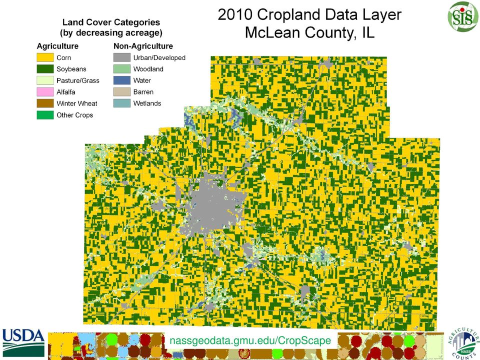
2 The Cropland Data Layer Census by Satellite Annually cover major program crops and regions Crops accurately geo-located Deliver in-season remote sensing acreage estimates NASS Official Reports Update planted area Reduce respondent burden Provide timely, accurate, useful estimates Measurable error Unbiased/independent/robust estimator State, District, County

3

4
5

6 CDL Visualization, Dissemination and Querying Needs Prior Dissemination Method: Online bulk FTP downloading via NRCS Geospatial Data Gateway Special request & delivery Printed maps CD/DVD delivery generated No online geospatial information access No geospatial crop visualization & browsing No geospatial query capability No geospatial online analytics NASS Needs Capabilities for on-line geospatial crop information access, geospatial query and online analytics via interactive maps Disseminate all data to decision makers and users via real time retrieval, processing and publishing over the web through standards-based geospatial web services

7 Solution - CropScape A web service based interactive map visualization, dissemination and querying system for U.S. cropland No burden on users No client software development & installation No special software tools needed Equitable cropland information access, automatic and timely delivery, geospatial navigation, retrieval, queries and dissemination Collaboration with George Mason University/ Center for Spatial Information Science and Systems

8
9 Technology Under the Hood Open Standard Geospatial Information Science Technology Adoption of specifications and standards from the OGC Sensor Web Enabled initiative: WFS, WCS, CSW, WMS, WPS etc. Re-using of SEPSeb Processing Service (WPS) Web Service Based Service Oriented Architecture Service Integration Support of workflows: BPEL execution engine Re-use all algorithms published in WPS GeoBrain Technology(GMU developed) Open, standards compliant, interoperable, distributed, web GIS Re-use functions/algorithms developed in GeoBrain
 Open, standards compliant,")
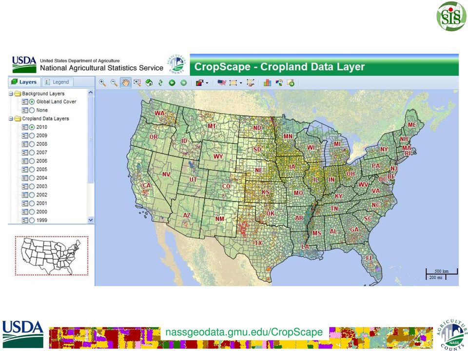
10 CropScape Functions Select any historical CDL by state and year circa 1997 Zoom in/out & Pan Search by county and year Sub-setting by state, county, and year Sub-setting for any area of interest by a bounding box Re-projecting data to a user specified map projection Albers, Geographic, UTM Download the CDL subset in GeoTiff format Exporting selected CDL subset to Google Earth (KML)

11 CropScape Functions Cont. Online pixel counting & acreage statistics Online statistics graphing/charting Maps showing the change of crop types for a state, county, or any area specified between any two years of CDL On-the-fly single/multi crop map generation, display and download Web service implemented Geospatial query statistics data delivery CDL map AOI data delivery


12 CropScape Defined Visual Tools Point Query Stats/Change/Download AOI Query Layer/Legend Map Overview


13 Select AOI State County ASD


14 Pie/Histogram/Graphic CropScape Stats Pixel counting is usually downward biased when compared to official estimates. Counting pixels and multiplying by the area of each pixel will result in biased area estimates and should be considered raw numbers needing bias correction. Official crop acreage estimates at the state and county level are available at


15 CropScape Change Analysis


16 CropScape Download & Export Preview and Download Specify Years and Projection

17 CropScape w/ Google Earth

18 Web Service Examples 1) 2) ps=19015&commcode= Year: 2008 State: IA County: Boone Commodity: Corn For Grain Planted: Harvested: Yield: Production: Service a) Service b)


19 CropScape Metrics

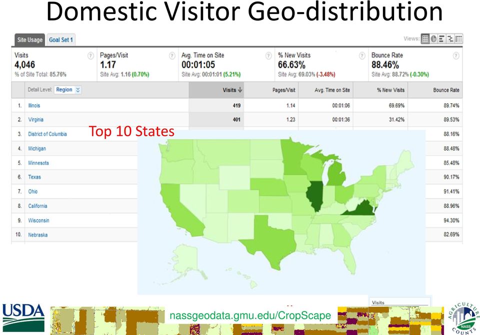
20 Domestic Visitor Geo-distribution Top 10 States All 50 States
21 CropScape Future Improvements Additional GIS layers watershed, congressional districts, roads Multi-year crop acreage statistical change graphics for state, county, or area Change analysis mapping Map production/printing services More analysis functions
22 CropScape Summary State of the art CDL visualization, querying and dissemination tool Interactive geospatial statistical analysis tools Online/interactive analytics, charting and mapping Geospatial information access, navigation CDL map and statistical result retrieval and dissemination web services Open geospatial standards compliant
23 Thank you! Spatial Analysis Research Section USDA/NASS R&D Division
ArcGIS Framework Plug-In: Extending the ArcGIS Desktop for ANSI Standard Framework Data to Support Government Decision Making
 ArcGIS Framework Plug-In: Extending the ArcGIS Desktop for ANSI Standard Framework Data to Support Government Decision Making Final Project Report October 28, 2008 Agreement Number Organization Project
ArcGIS Agricultural Land Use Maps from the Mississippi Cropland Data Layer
 ArcGIS Agricultural Land Use Maps from the Mississippi Cropland Data Layer Fred L. Shore, Ph.D. Mississippi Department of Agriculture and Commerce Jackson, MS, USA [email protected] Rick Mueller
Oklahoma s Open Source Spatial Data Clearinghouse: OKMaps
 Oklahoma s Open Source Spatial Data Clearinghouse: OKMaps Presented by: Mike Sharp State Geographic Information Coordinator Oklahoma Office of Geographic Information MAGIC 2014 Symposium April 28-May1,
GXP WebView GEOSPATIAL EXPLOITATION PRODUCTS (GXP )
") GEOSPATIAL EXPLOITATION PRODUCTS (GXP ) GXP WebView A Web-based, full-resolution image viewing tool for visualization, annotation, measurement, and publishing providing access to remote data from any location.
GEOSPATIAL EXPLOITATION PRODUCTS (GXP ) GXP WebView A Web-based, full-resolution image viewing tool for visualization, annotation, measurement, and publishing providing access to remote data from any location.
What s new in Carmenta Server 4.2
 What s new in Carmenta Server 4.2 A complete solution for cost-effective visualisation and distribution of GIS data through web services Carmenta Server provides cost-effective technology for building
Geospatial exploitation Products. GXP WebView. Powered by the GXP Platform
 Geospatial exploitation Products GXP WebView Powered by the GXP Platform Exploitation Capabilities GXP WebView Powered by the GXP Platform Detailed annotation (text, points, lines, and polygons) Distance,
INTEROPERABLE IMAGE DATA ACCESS THROUGH ARCGIS SERVER
 INTEROPERABLE IMAGE DATA ACCESS THROUGH ARCGIS SERVER Qian Liu Environmental Systems Research Institute 380 New York Street Redlands, CA92373, U.S.A - [email protected] KEY WORDS: OGC, Standard, Interoperability,
The ORIENTGATE data platform
 Seminar on Proposed and Revised set of indicators June 4-5, 2014 - Belgrade (Serbia) The ORIENTGATE data platform WP2, Action 2.4 Alessandra Nuzzo, Sandro Fiore, Giovanni Aloisio Scientific Computing and
BLACKBRIDGE SATELLITE IMAGERY THROUGH CLOUD COMPUTING
 BLACKBRIDGE SATELLITE IMAGERY THROUGH CLOUD COMPUTING Jason Setzer Cloud Product Manager Slide 1 THE RAPID EYE CONSTELLATION 5 Identical Satellites in same obit Up to 5 million km² collected daily 1 billion
There are various ways to find data using the Hennepin County GIS Open Data site:
 Finding Data There are various ways to find data using the Hennepin County GIS Open Data site: Type in a subject or keyword in the search bar at the top of the page and press the Enter key or click the
Web-based spatio-temporal visualization and analysis of the Siberian Earth System Science Cluster (SIB-ESS-C)
") Web-based spatio-temporal visualization and analysis of the Siberian Earth System Science Cluster (SIB-ESS-C) Roman Gerlach Supervisor: Prof. C. Schmullius (Dept. of Geography, Friedrich-Schiller-University
Web-based spatio-temporal visualization and analysis of the Siberian Earth System Science Cluster (SIB-ESS-C) Roman Gerlach Supervisor: Prof. C. Schmullius (Dept. of Geography, Friedrich-Schiller-University
Figure 2: System Flow Diagram for Workflow Management
 5. WORKFLOW MANAGEMENT The developed system EASKB uses the open source content management system called Drupal ([2]). A Content Management System - CMS is a tool that enables many user friendly features
CURSO Inspire INSPIRE. SPEAKER: Pablo Echamendi Lorente. JEUDI 23/ THURSDAY 23 rd W S V : G E O S P A T I A L D A T A A C C E S S
 CURSO Inspire JEUDI 23/ THURSDAY 23 rd SPEAKER: Pablo Echamendi Lorente WS 5 SCHEDULE WMS OVERVIEW ACTIONS OGC SPECIFICATIONS OTHER SERVICES OVERVIEW proposal: Member States shall establish and operate
Big Data Volume & velocity data management with ERDAS APOLLO. Alain Kabamba Hexagon Geospatial
 Big Data Volume & velocity data management with ERDAS APOLLO Alain Kabamba Hexagon Geospatial Intergraph is Part of the Hexagon Family Hexagon is dedicated to delivering actionable information through
A Fresh Approach to Agricultural Statistics: Data Mining and Remote Sensing
 A Fresh Approach to Agricultural Statistics: Data Mining and Remote Sensing Abstract Darcy Miller, Jaki McCarthy, Audra Zakzeski National Agricultural Statistics Service 3251 Old Lee Highway, Fairfax,
Standardized data sharing through an open-source Spatial Data Infrastructure: the Afromaison project
 Standardized data sharing through an open-source Spatial Data Infrastructure: the Afromaison project Yaniss Guigoz - University of Geneva/GRID-Geneva 1 EcoARM2ERA and AFROMAISON Why Afromaison in this
Gram Panchayat & Ward Boundary Delineation and Assets mapping
 Gram Panchayat & Ward Boundary Delineation and Assets mapping For Rural Development Department & State Election Commission, Govt. of Maharashtra MAHARASHTRA REMOTE SENSING APPLICATIONS CENTRE Autonomous
Open Source Visualisation with ADAGUC Web Map Services
 Open Source Visualisation with ADAGUC Web Map Services Maarten Plieger Ernst de Vreede John van de Vegte, Wim Som de Cerff, Raymond Sluiter, Ian van der Neut, Jan Willem Noteboom 1 ADAGUC project Cooperative
SuperGIS Server 3.2 Standard Edition Specification
 SuperGIS Server 3.2 Standard Edition Specification 20140826 Specification 1. All of the services support SOAP (Simple Object Access Protocol). 2. Use map file created by SuperGIS Desktop as map services
UK Location Programme
 Location Information Interoperability Board Data Publisher How To Guide Understand the background to establishing an INSPIRE View Service using GeoServer DOCUMENT CONTROL Change Summary Version Date Author/Editor
VISUALIZATION OF A CROP SEASON THE INTEGRATION OF REMOTELY SENSED DATA AND SURVEY DATA
 VISUALIZATION OF A CROP SEASON THE INTEGRATION OF REMOTELY SENSED DATA AND SURVEY DATA Gail Wade GIS Analyst, Spatial Analysis Research Section George Hanuschak Chief, Geospatial Information Branch Research
Web and Mobile GIS Applications Development
 Web and Mobile GIS Applications Development Presented by : Aamir Ali Manager Section Head (GIS Software Customization) Pakistan Space and Upper Atmosphere Research Commission (SUPARCO) Geographical Information
Sextant. Spatial Data Infrastructure for Marine Environment. C. Satra Le Bris, E. Quimbert, M. Treguer
 Sextant On-Line information system for marine geographical information E. Quimbert, M. Bellouis, F. Lecuy, M. Treguer Centre de Bretagne BP 70, Plouzané 29280 France E-mail: [email protected] Sextant
Environment Canada Data Management Program. Paul Paciorek Corporate Services Branch May 7, 2014
 Environment Canada Data Management Program Paul Paciorek Corporate Services Branch May 7, 2014 EC Data Management Program (ECDMP) consists of 5 foundational, incremental projects which will implement
MSDI: Workflows, Software and Related Data Standards
 MSDI: Workflows, Software and Related Data Standards By Andy Hoggarth October 2009 Introduction Leveraging SDI principles for hydrographic operational efficiency French INFRAGEOS example (SHOM - Service
GIS AS A DECISION SUPPORT FOR SUPPLY CHAIN MANAGEMENT
 Paper Reference No.: PN-253 GIS AS A DECISION SUPPORT FOR SUPPLY CHAIN MANAGEMENT Sanjay Kumar 1 and Suneeta Agrawal 2 1. M. Tech. (GIS & Remote Sensing); GIS Cell; MNNIT, Allahabad, India (E-mail: [email protected])
How To Use Gis
 Welcome Understanding Purpose Creating Relationships You A Global Community of GIS Professionals Changing the World Together Applying Geography Everywhere Your WORK Showcasing Your Web Apps Vision Applying
ArcGIS. Server. A Complete and Integrated Server GIS
 ArcGIS Server A Complete and Integrated Server GIS ArcGIS Server A Complete and Integrated Server GIS ArcGIS Server enables you to distribute maps, models, and tools to others within your organization
GeoNetwork, The Open Source Solution for the interoperable management of geospatial metadata
 GeoNetwork, The Open Source Solution for the interoperable management of geospatial metadata Ing. Emanuele Tajariol, GeoSolutions Ing. Simone Giannecchini, GeoSolutions GeoSolutions GeoSolutions GeoNetwork
smespire - Exercises for the Hands-on Training on INSPIRE Network Services April 2014 Jacxsens Paul SADL KU Leuven
 smespire - Exercises for the Hands-on Training on INSPIRE Network Services April 2014 Jacxsens Paul SADL KU Leuven These exercises aim at people who already have some basic knowledge of INSPIRE Network
Keystone Image Management System
 Image management solutions for satellite and airborne sensors Overview The Keystone Image Management System offers solutions that archive, catalogue, process and deliver digital images from a vast number
Vision. South Pacific GIS/RS Conference 2015 11/17/2015. Applying Geography Everywhere. Applying Geography Everywhere
 South Pacific GIS/RS Conference 2015 Applying Geography Everywhere Jithen (J) Singh Eagle Technology Group Ltd (Esri New Zealand) Suva, Fiji Vision Applying Geography Everywhere 1 GIS Is Evolving A Whole
Choosing the right GIS framework for an informed Enterprise Web GIS Solution
 13 ANNUAL INTERNATIONAL CONFERENCE AND EXHIBITION ON GEOSPATIAL INFORMATION TECHNOLOGY AND APPLICATIONS Epicentre; Gurgaon, India; 19-21 January, 2010 Choosing the right GIS framework for an informed Enterprise
Metadata for Data Discovery: The NERC Data Catalogue Service. Steve Donegan
 Metadata for Data Discovery: The NERC Data Catalogue Service Steve Donegan Introduction NERC, Science and Data Centres NERC Discovery Metadata The Data Catalogue Service NERC Data Services Case study:
Version 3.0, April 16, 2012, updated for ArcGIS 10.0 Produced by the Geographic Information Network of Alaska http://www.gina.alaska.
 Using the AlaskaMapped Web Services in ESRI ArcGIS Version 3.0, April 16, 2012, updated for ArcGIS 10.0 Produced by the Geographic Information Network of Alaska http://www.gina.alaska.edu AlaskaMapped
 Development tools to create Web-GIS applications DbMAP ASJ the best solution to easily publish GIS data from existing spatial databases and distributed GIS data sources Easily designs, produces, and publishes
The use of Semantic Web Technologies in Spatial Decision Support Systems
 The use of Semantic Web Technologies in Spatial Decision Support Systems Adam Iwaniak Jaromar Łukowicz Iwona Kaczmarek Marek Strzelecki The INSPIRE Conference 2013, 23-27 June Wroclaw University of Environmental
Smart Cities require Geospatial Data Providing services to citizens, enterprises, visitors...
 Cloud-based Spatial Data Infrastructures for Smart Cities Geospatial World Forum 2015 Hans Viehmann Product Manager EMEA ORACLE Corporation Smart Cities require Geospatial Data Providing services to citizens,
http://opendata.comune.fi.it
 The Environmental Observation Web and its Service Applications within the Future Internet OPENDATA IN CITY OF FLORENCE Gianluca Vannuccini Head of the IT Infrastructure Development Office IT Department
Managing a Geographic Database From Mobile Devices Through OGC Web Services
 Managing a Geographic Database From Mobile Devices Through OGC Web Services Nieves R. Brisaboa 1, Miguel R. Luaces 1, Jose R. Parama 1, and Jose R. Viqueira 2 1 Database Laboratory, University of A Coruña,
DEVELOPMENT OF REAL-TIME TRACKING & LOG MANAGEMENT SYSTEM USING FREE AND OPEN SOURCE SOFTWARE
 DEVELOPMENT OF REAL-TIME TRACKING & LOG MANAGEMENT SYSTEM USING FREE AND OPEN SOURCE SOFTWARE Daisuke Yoshida and Venkatesh Raghavan Graduate School for Creative Cities, Osaka City University 3-3-138 Sugimoto,
An Esri White Paper June 2011 ArcGIS for INSPIRE
 An Esri White Paper June 2011 ArcGIS for INSPIRE Esri, 380 New York St., Redlands, CA 92373-8100 USA TEL 909-793-2853 FAX 909-793-5953 E-MAIL [email protected] WEB esri.com Copyright 2011 Esri All rights reserved.
Secure your GIS. Protecting GIS applications suites. camptocamp / 9. septembre 2010 / www.camptocamp.com / [email protected]
 Secure your GIS Protecting GIS applications suites camptocamp / 9. septembre 2010 / www.camptocamp.com / [email protected] Outline - Camptocamp SA - Introduction Green field Heterogenous FOSS applications
Design Requirements for an AJAX and Web-Service Based Generic Internet GIS Client
 11th AGILE International Conference on Geographic Information Science 2008 Page 1 of 6 Design Requirements for an AJAX and Web-Service Based Generic Internet GIS Client Edward Nash 1, Peter Korduan 1,
ishare in the Cloud Service Definition v5.0
 Service Definition v5.0 An overview of ishare in the Cloud ishare is an end to end Enterprise GIS for public sector comprising a spatial data warehouse, rich functionality browser based GIS including editing
Institute of Computational Modeling SB RAS
 Institute of Computational Modeling SB RAS ORGANIZATION OF ACCESS TO OBSERVATIONAL DATA USING WEB SERVICES FOR MONITORING SYSTEMS THE STATE OF THE ENVIRONMENT Kadochnikov Aleksey A. Russia, Krasnoyarsk
2009 CAP Grant Kickoff USGS, Reston, VA May 21, 2009
 Leveraging GOS Map and Data Services for Search and Rescue Operations using NASA WorldWind Open Source 3D Visualization Platform Nadine Alameh, Ph.D. MobiLaps LLC 2009 CAP Grant Kickoff USGS, Reston, VA
Web-based Participatory GIS with data collection on the field: a prototype architecture in two and three dimensions
 8 Convegno Nazionale del Gruppo di Geologia Informatica Sezione della Società Geologica Italiana Chiavenna (SO), 17-19 giugno 2013 Ex Convento dei Cappuccini, Via Molinanca DICA Laboratorio di Geomatica
GOSIC NEXRAD NIDIS NOMADS
 NOAA National Climatic Data Center GOSIC NEXRAD NIDIS NOMADS Christina Lief NOAA/NESDIS/NCDC GOSIC Program Manager NOAA/NESDIS/NCDC Asheville, NC 28801 GEOSS AIP Phase 2 Workshop September 25-26, 2008
EXPLORING AND SHARING GEOSPATIAL INFORMATION THROUGH MYGDI EXPLORER
 EXPLORING AND SHARING GEOSPATIAL INFORMATION THROUGH MYGDI EXPLORER Subashini Panchanathan Malaysian Centre For Geospatial Data Infrastructure ( MaCGDI ) Ministry of National Resources and Environment
Implementation of information system to respond to a nuclear emergency affecting agriculture and food products - Case of Morocco
 Centre National de l énergie des sciences et techniques nucléaires (CNESTEN-Morocco) Implementation of information system to respond to a nuclear emergency affecting agriculture and food products - Case
AN INTEGRATED SOLUTION FOR MANAGING EXPLORATION DATA
 www.wipro.com AN INTEGRATED SOLUTION FOR MANAGING EXPLORATION DATA Sandipan Chakraborti, Senior Architect ENU Table of Contents 03... Introduction 04... Lack of Holistic View 06... Figure 1: Conceptual
OGC at KNMI: Current use and plans Available products
 OGC at KNMI: Current use and plans Available products Maarten Plieger KNMI R&D Ernst de Vreede, John van de Vegte, Wim Som de Cerff, Ian van der Neut, Raymond Sluiter, Jan Willem Noteboom Contents 1. ADAGUC
Linking Sensor Web Enablement and Web Processing Technology for Health-Environment Studies
 Linking Sensor Web Enablement and Web Processing Technology for Health-Environment Studies Simon Jirka 1, Stefan Wiemann 2, Johannes Brauner 2, and Eike Hinderk Jürrens 1 1 52 North Initiative for Geospatial
Distributed System Architectures, Standardization, and Web-Service Solutions in Precision Agriculture
 1 Distributed System Architectures, Standardization, and Web-Service Solutions in Precision Agriculture KATJA POLOJÄRVI Oulu University of Applied Sciences, School of Renewable Natural Resources, Oulu,
Geospatially Enabling the World: The Convergence of Geospatial and Architectural and Engineering Design
 Geospatially Enabling the World: The Convergence of Geospatial and Architectural and Engineering Design Geoff Zeiss Director of Technology Autodesk Map Middle East Dubai 2007 1 Overview Geospatial inflection
From Geoportal to Spatial Data Service Platform. Jani Kylmäaho National Land Survey of Finland Development Centre
 From Geoportal to Spatial Data Service Platform Jani Kylmäaho National Land Survey of Finland Development Centre 29.6.2012 Introduction National Land Survey of Finland - 1900 employees Development Centre
OPEN STANDARD WEB SERVICES FOR VISUALISATION OF TIME SERIES DATA OF FLOOD MODELS
 OPEN STANDARD WEB SERVICES FOR VISUALISATION OF TIME SERIES DATA OF FLOOD MODELS Barend Köbben FRMRC RPA 7 Workshop visualisations and flow simulations as flood risk communication tools
Watershed Ecosystem & Restoration Services (WERS Mapping Application) User s Guide
 User s Guide") Watershed Ecosystem & Restoration Services (WERS Mapping Application) User s Guide CONTACT Site Administrators: David Gillum, GISP, AACO, OIT Rick Fisher, AACO, WERS [email protected] [email protected]
Watershed Ecosystem & Restoration Services (WERS Mapping Application) User s Guide CONTACT Site Administrators: David Gillum, GISP, AACO, OIT Rick Fisher, AACO, WERS [email protected] [email protected]
GEOSPATIAL DIGITAL ASSET MANAGEMENT A SOLUTION INTEGRATING IMAGERY AND GIS WHERE WILL ALL THE PIXELS GO?(AND HOW WILL WE EVER FIND THEM?
 GEOSPATIAL DIGITAL ASSET MANAGEMENT A SOLUTION INTEGRATING IMAGERY AND GIS WHERE WILL ALL THE PIXELS GO?(AND HOW WILL WE EVER FIND THEM?) Dr. Joan Lurie, GCC, Inc. 30 West 61 st Street, Apt 9A New York,
U.S. Geological Survey Earth Resources Operation Systems (EROS) Data Center
 Data Center") U.S. Geological Survey Earth Resources Operation Systems (EROS) Data Center World Data Center for Remotely Sensed Land Data USGS EROS DATA CENTER Land Remote Sensing from Space: Acquisition to Applications
U.S. Geological Survey Earth Resources Operation Systems (EROS) Data Center World Data Center for Remotely Sensed Land Data USGS EROS DATA CENTER Land Remote Sensing from Space: Acquisition to Applications
Advanced Image Management using the Mosaic Dataset
 Esri International User Conference San Diego, California Technical Workshops July 25, 2012 Advanced Image Management using the Mosaic Dataset Vinay Viswambharan, Mike Muller Agenda ArcGIS Image Management
INSPIRE in practice: Experiences with INSPIRE data and services
 INSPIRE in practice: Experiences with INSPIRE data and services Peter Parslow Principal Geographic Information Architect June 2014: ISO TC211 Standards in Practice workshop What s INSPIRE? European Commission
Arches: An Open Source GIS for the Inventory and Management of Immovable Cultural Heritage
 Arches: An Open Source GIS for the Inventory and Management of Immovable Cultural Heritage David Myers 1, Alison Dalgity 1, Ioannis Avramides 2, and Dennis Wuthrich 3 1 The Getty Conservation Institute,
Jozef Matula. Visualisation Team Leader IBL Software Engineering. 13 th ECMWF MetOps Workshop, 31 th Oct - 4 th Nov 2011, Reading, United Kingdom
 Visual Weather web services Jozef Matula Visualisation Team Leader IBL Software Engineering Outline Visual Weather in a nutshell. Path from Visual Weather (as meteorological workstation) to Web Server
HydroDesktop Overview
 HydroDesktop Overview 1. Initial Objectives HydroDesktop (formerly referred to as HIS Desktop) is a new component of the HIS project intended to address the problem of how to obtain, organize and manage
EUMETSAT EO Portal. End User Image Access using OGC WMS/WCS services. EUM/OPS/VWG/10/0095 Issue <1> <14/01/2010> Slide: 1
 EUMETSAT EO Portal End User Image Access using OGC WMS/WCS services Slide: 1 Overview Introduction: status of data access and visualization EUMETSAT datasets Architecture Web Map Service implementation
Product Navigator User Guide
 Product Navigator User Guide Table of Contents Contents About the Product Navigator... 1 Browser support and settings... 2 Searching in detail... 3 Simple Search... 3 Extended Search... 4 Browse By Theme...
OBJECT BASED IMAGE CLASSIFICATION AND WEB-MAPPING TECHNIQUES FOR FLOOD DAMAGE ASSESSMENT
 OBJECT BASED IMAGE CLASSIFICATION AND WEB-MAPPING TECHNIQUES FOR FLOOD DAMAGE ASSESSMENT Ejaz Hussain, KyoHyouk Kim, Jie Shan {ehussain, kim458, jshan}@ecn.purdue.edu Geomatics Engineering, School of Civil
GEOCOM PROJECT INTEGRATING DATA & TECHONOLOGIES
 GEOCOM PROJECT INTEGRATING DATA & TECHONOLOGIES Lucio Colaiacomo Chief Technology Officer [email protected] Rationale for the project Providing support through our domain background & tech. expertise
DataTube: web services voor data
 DataTube: web services voor data Gerben de Boer Onno van de Akker Gerrit Hendriksen Deltares, Matroos Deltares, FEWS Deltares, NHI FEWS & Matroos: database > viewers VIEWER client 3 rd party viewer Matroos
SuperGeo Rugged Personal GIS Solution - Mobile GIS Expert Specification
 SuperGeo Rugged Personal GIS Solution - Mobile GIS Expert Specification Mobile GIS Expert is one of SuperGeo s Rugged Personal GIS Solutions, which includes Getac PS535 Rugged GPS PND and SuperPad 2.1
Outlook for the 2013 U.S. Farm Economy
 Outlook for the 213 U.S. Farm Economy Kevin Patrick Farm and Rural Business Branch Resource and Rural Economics Division Highlights Net farm income in 213 forecast: $128.2 billion Net cash income in 213
VITO Centre of Image Processing
 07/11/2013 VITO Centre of Image Processing Towards an Improved Scientific Exploitation of EO Data Sources in Support of Vegetation Monitoring Erwin Goor, VITO nv Outline» Introduction» The role & and objectives
Web Mapping technologies for the valorization of slow tourism: the Via Regina project
 Web Mapping technologies for the valorization of slow tourism: the Via Regina project Maria Antonia Brovelli, Candan Eylul Kilsedar, Marco Minghini, Giorgio Zamboni Politecnico di Milano (DICA) Laboratorio
Intergraph Geospatial Portfolio 2013
 W H A T S N E W? Intergraph Geospatial Portfolio 2013 Photogrammetry LPS ImageStation Remote Sensing ERDAS IMAGINE GIS GeoMedia Server GeoMedia WebMap GeoMedia Smart Client ERDAS APOLLO Geospatial SDI
Visualizing Historical Agricultural Data: The Current State of the Art Irwin Anolik (USDA National Agricultural Statistics Service)
") Visualizing Historical Agricultural Data: The Current State of the Art Irwin Anolik (USDA National Agricultural Statistics Service) Abstract This paper reports on methods implemented at the National Agricultural
Visualizing Historical Agricultural Data: The Current State of the Art Irwin Anolik (USDA National Agricultural Statistics Service) Abstract This paper reports on methods implemented at the National Agricultural
The Big Data Integration and Analytics Revolution in Agricultural Finance, Risk, and Insurance
 The Big Data Integration and Analytics Revolution in Agricultural Finance, Risk, and Insurance Joshua D. Woodard Assistant Professor and Zaitz Faculty Fellow in Agribusiness and Finance Dyson School of
Portal for ArcGIS. Satish Sankaran Robert Kircher
 Portal for ArcGIS Satish Sankaran Robert Kircher ArcGIS A Complete GIS Data Management Planning & Analysis Field Mobility Operational Awareness Constituent Engagement End to End Integration Collect, Organize,
Making MAGIC with Your Data: Interactive Maps, Map Mashups, and Data Visualization Tools
 Making MAGIC with Your Data: Interactive Maps, Map Mashups, and Data Visualization Tools Michael Howser Connecticut State Data Center Coordinator & Undergraduate Education & GIS Librarian What is the Connecticut
Enterprise GIS Solutions to GIS Data Dissemination
 Enterprise GIS Solutions to GIS Data Dissemination ESRI International User Conference July 13 17, 2009 Wendy M. Turner Senior GIS Engineer & Program Manager Freedom Consulting Group, LLC Building the Enterprise
GeoMedia Product Update. Title of Presentation. Lorilie Barteski October 15, 2008 Edmonton, AB
 Product Update Title of Presentation Lorilie Barteski Edmonton, AB Know the audience poll Existing /Pro users Version 6.1 Version 6.0 Version 5.2 or earlier Existing WebMap users Version 6.1 Version 6.0
A FRAMEWORK OF WEB-BASED SERVICE SYSTEM FOR SATELLITE IMAGES AUTOMATIC ORTHORECTIFICATION
 A FRAMEWORK OF WEB-BASED SERVICE SYSTEM FOR SATELLITE IMAGES AUTOMATIC ORTHORECTIFICATION Jiaojiao Tian, Xinming Tang, Huabin Wang Key Laboratory of Geo-informatics of State Bureau of Surveying and Mapping,
VISUAL INSPECTION OF EO DATA AND PRODUCTS - OVERVIEW
 WMS services from the EUMETSAT real-time Image Gallery Uwe Voges (1), Michael Schick (2), Udo Einspanier (1) (1) con terra GmbH Martin-Luther-King-Weg 24, 48155, Münster, Germany EMail: (U.Voges U.Einspanier)@conterra.de
THE SPATIAL DATA INFRASTRUCTURE OF SPAIN AS AN EXAMPLE OF SUCCESS IN EUROPE
 THE SPATIAL DATA INFRASTRUCTURE OF SPAIN AS AN EXAMPLE OF SUCCESS IN EUROPE Julio Mezcua-Rodríguez ([email protected]) Instituto Geográfico Nacional (National Geographic Institute). General Ibañez Ibero,
AN OPENGIS WEB MAP SERVER FOR THE ESA MULTI-MISSION CATALOGUE
 AN OPENGIS WEB MAP SERVER FOR THE ESA MULTI-MISSION CATALOGUE T. Westin a, *, C. Caspar b, L. Edgardh a, L. Schylberg c a Spacemetric AB, Tingsv 19, 19161 Sollentuna, Sweden - [email protected] b ESA Esrin,