TERRAIN GUIDE OF CHENNAI CITY
|
|
|
- Julianna Williamson
- 7 years ago
- Views:
Transcription
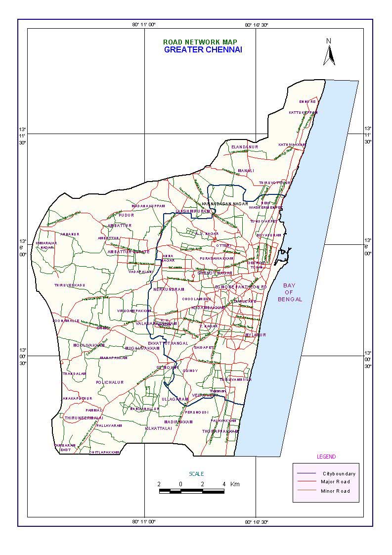
1 TERRAIN GUIDE OF CHENNAI CITY Introduction Chennai and its suburbs constituting the Chennai Metropolitan Area (CMA) are constantly plagued by water shortage. Rapid growth in population, coupled with irregular spells of monsoons has further intensified the problem in the past couple of years. The population of Chennai is expected to cross 4.5 million by the end of The city at the moment requires 848 million litres per day (MLD). Whereas the public system was able to supply only 433 MLD. The balance of nearly 50% of the daily consumption is met through private wells and borewells (groundwater). As a result of this unplanned large scale extraction of groundwater the water table in the city is depleting at an alarming rate causing serious quality problems. Hence it becomes essential to sustain the available limited groundwater sources through rainwater harvesting. To design a proper rainwater harvesting system for groundwater recharge, parameters such as Geology, Hydrogeology and Hydrometeorology is required. As the Geology of Chennai city is highly complex and heterogeneous in nature, rainwater harvesting systems designed without considering the local hydro geological set up will not yield the desired results. The present study is to bring out an over view of the sub terrain configuration in Chennai city based on which terrain specific water harvesting systems can be designed. CITY AT A GLANCE Location Chennai District is bounded by North Latitudes and and east Longitudes and and forms part of survey of India Topographical Maps Nos. 66 C / 4 & and 66 D 1 and 5. The Geographical area of Chennai district is Sq. km and the extent of Chennai Metropolitan Area is 1170 Sq. km. (Refer Base map)
2 Land use and Administration.
3 The Forest Cover in Chennai district is only 300 ha (1.8 percent) and the rest 98.2 per cent of the areas is used for industrial purposes. The residential areas can be grouped as Prime residential, Commerical, mixed residential and slum areas. Presentely there are five taluks in the district, namely (i) Purasavalkam Perambur (ii) Fort Tondiarpet (iii) Mambalam- Guindy (iv) Mylapore Triplicane (v) Egmore - Nungambakkam Profile of Chennai Metropolitan area (Part) - General Features Statistics. 1. Location Chennai city and part of Tambaram taluk. 2. Total area 174 sq km. 3. Population lakh (city) 65.0 L (Metropolitan area) 4. Major rivers traversing the area Adyar and Cooum, Otteri nullah. 5. Canal Buckingham canal 6. Mean Annual Rainfall (50 yr) 1320 mm 7. Cooum and Adyar basin Rainfall 50% dependability SW NE Annual Population density 24,231 persons / sq km. 9. Geology Crystalline basement rock, Upper Gondwanas, Tertiary and Recent to Sub Recent Alluvium. 10. Terrain slope 1: Forest cover hectare (1.5% of the total area under forest) 12. Cultivable waste 3,48,497 hectare (8,60,788 acres) 13. Cultivable Fallow 9,55,507 hectare (23,60,102 acres) 14. Other fallow 11,10,728 hectare (27,43,498 acres) Total - 24,14,732 hectares (59,64,388 acres) 15. Sewerage generation 540 mld (city only) 16. Garbage generation 3000 tones/ day. (2400 tones biodegradable in city only) 17. Corporation roads 302 km 18. Bus route& interior roads 1900 km 19. Total vehicle population 13,00,000 (2001 approx) 20. Industries in Chennai 770 (as on 2000) 21. Coastline 22 km (city only) 22. Water supply during normal RF 78 lit per capita a day (LPCD) 313 mld 23. During drought period 127 mld 32 LPCD. (Based on Tamil Nadu Land Use Board statistics).
4
5 GEOMORPHOLOGY Chennai district forms parts of Tamilnadu costal plains. Major part of the district is having flat topography with very gentle slope towards east. The altitude of land surface varies from 10 m above MSL in the west to sea level in the east. Fluvial, Marine transgression and regression and neo tectonic activity resulted in various present land forms. Meandering streams with small sand bars are present along the course of Adayar River. The river shows some sharp angular trends in its course which may be the indication of the hidden structural features below. The pediment and buried pediment in Guindy area in and around the reserved forest, are the only areas where the geological system is less disturbed while the other areas are completely disturbed by built up areas with large scale human interference and pollution. The number of water bodies existed in the district in the early period of this century were filled up with garbage, ( eg Valluvar kottam areas) transported sand and clay ( number of small ponds). The sand dunes and beach ridges were also converted into residential areas and as a result the natural landform got altered. Marina beach is the most natural beach in the world with a width varying from 150m to 600 m and a length of 5.6Km, also encroached by human activity. The marshy land and lagoon existing north of Adayar river are also transformed into build up areas. Theosophical Society, located on the banks of Adayar river mouth is the only area with wellpreserved natural coastal morphology, sand dunes, beach ridges, flora etc. DRAINAGE Adayar river originates at the confluence (Thiruneermalai) of two streams that drain the upstream area of Chembarambakkam tank. It is a small river of 42km length and a catchment of 800 sq.km. The river carries flow all through 365 days of a year with an Average discharge of MCM/ year at Kathipara cause way. It drains the southern part of the district and remains flooded during monsoon. During the high tides, the back waters from the Bay of Bengal enter inland upto 3-4 km. Cooum is the other main river flowing through the middle part of district and carries only drainage water which is highly polluted. It originates from the surplus flow of the cooum tank in Tiruvallore taluk and also from the tanks enroute which discharge their surplus water into the river during flood season. The flow of Cooum river at Korattur is 40.2 MCM/year for an average duration of 31 days in a year. The number of days of maximum flow are 78 in & and the maximum discharge was 25.4 MCM in a day (on ). Otteri Nulla is another small stream flowing in the northern part of the city. Buckingham canal is the main man-made channel used for navigational purposes in the area north of Ennore, but acts as sewerage carrier in the city.(refer drainage map of Chennai)

6
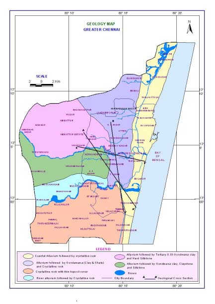
7 There were about 162 small ponds and tanks in North Chennai north of Cooum river, 20 ponds and tanks in central Chennai between Cooum and Adyar and 17 to the south of Adayar river. Of these 35 were temple tanks. These tanks acted as major recharge structures for the city area. But constant depletion of water table, encroachment of catchment and diversion of inlets has made most of these water bodies dry. HYDROMETEOROLOGY Climate Chennai district enjoys a tropical climate with mean annual temperature of 24.3 o c{min} to 32.9 o c(max). the hottest and driest part of the year is April May Temperature rise to 41.2 o c, the extremes recorded are 13.9 o c and 45 o c. The lowest temperatures recorded in the range of 18.1 o c to 25.9 o c are in January. The humidity is usually in the range of 58 to 84% and sea-breeze in the evening hours is a blessing to combat the high temperature and humidity during summer months. The weather stations are located at Meenambakkam and Nungambakkam. Rainfall The North East monsoon during the months of October, November and December chiefly contributes the rainfall for the district. Most of the precipitation occurs in the form of one or two cyclones caused due to depressions in Bay of Bengal. The southwest monsoon rainfall is highly erratic and summer rains are negligible. The average annual rainfall of the district is in the range of to mm. The analysis of rainfall pattern at Nungambakkam and Mennambakkam indicate a wide variation within short distances and also from year to year. The frequency of mild drought is noticed at 21 years in the last 90 years duration, which means mild drought is expected once in 4 years. With precipitation of 0 to -25% The moderate drought (-25 to -50%) is experienced only in 8 years(9%) in the 90 years period and severe drought is very rare. The average annual rainfall in the district is higher than the state average and rainy days are also distributed throughout the year and 4 to 10 days rain in June to December is common. GEOLOGY AND STRUCTURE Chennai district is underlain by various geological formations from the ancient Archaeans to the Recent Alluvium. (Refer Geology Map). The geological formations of the district can be grouped into three units, namely (i) Archaean crystalline rocks (ii) Consolidated Gondwana and Tertiary sediments and (iii) Recent alluvium. Most of the geological formations are concealed since overlain by the alluvial materials excepting for a few exposures of crystalline rocks like charnockites along the railway track in Guindy area
8
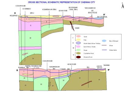
9 Archaean Crystallines The Archaean crystalline rocks of the district comprise chiefly of charnockites, gneisses, and associated basic and ultra basic intrusives. The charnockites represent the major rock type in the area extending from Saidapet to Ramapuram. The charnockites also constitute the residual hills around Pallavaram, St.Thomas Mount, Vandalur. The crystalline rocks are weathered and jointed /fractured. The degree and depth of weathering varies from place to place and thickness of weathered mantle varies from less than a metre to about 12m in the district. There are more than two sets of joints in the crystalline rocks. The successful borewells drilled tapping the deeper fractured aquifers in Saidapet, Adyar, Kasturba Nagar, Gandhi Nagar and Ashok Nagar revealed the existence of fracturing down to depths of 60m below ground level. Near the War Memorial 2km south of Adayar river borewells encountered fractures down to 60m. A basic dyke of 30m width has recently been noticed on the southern side of Velachery lake and extends over 200m. Gondwana and Tertiary Sediments The Gondwana rocks are seen along the Adyar river bed outside Chennai, but no exposures are observed in the city. The Gondwana sediments are represented by sandstones, shales and clays. The shales and clays are highly consolidated. The Goundwana shales are exposed in Adayar river near Ramavaram and the Gondwana-crystalline contact (refer cross section-1) is a probable fault contact concealed by alluvium. The Gondwana shales are jointed/fractured and their thickness varies from 24m in Kilpauk, 20m in Ashok nagar and 130m in Koyambedu. The Tertiary sandstones are reddish brown to grayish white and white in colours friable and mottled. The occurrence of Tertiaries in Chennai is not well demarcated. However. the Tertiary sediments seem to have been of limited thickness and often difficult to distinguish between compact alluvial sands during drilling. Recent Alluvium The alluvium covers the major part of the district, but for the localized crystalline pockets in south Chennai in Gandhi Mandapam Saidapet Railway Station area. The alluvium consists of sand, silt and clay. The thickness of alluvium varies from place to place and a maximum of 28m is encountered in North Chennai near Perambur. Kilpauk water works area has 24m thick alluvium. Sub-Surface Geology The sub-surface basement configuration in Chennai district could not be precisely evolved due to paucity of data. Based on the lithological data collected from
10 various Government and Private agencies engaged in the construction of bore wells in Chennai district, the geological succession in the Madras district was prepared. The presence of Gondwana shale is established in T. Nagar, kodambakkam and Nungambakkam areas.. Basement high is noticed near Ashok Pillar and Jafferkhanpet areas. Basement high is also noticed in Villiwakkam area. The crystalline rocks are directly encountered below alluvium in Teynampet, Saidapet, Adayar and Velachery areas. The presence of thick black clay followed by fossil bed (old lagoon probably) and then crystalline rocks below 6m depth is a common feature in the vast stretch between Lattice Bridge road to Velacherry. (Refer Cross Sections 1 and 2) Tectonics The presence of fault in crystalline basements is clear at Sterling road and at Nandyambakkam. The crystalline rock ridge running parallel to mount road has separated the district into two basins, southern basin shallow without Gondwana sediments. The northern side has extensive Gondwana sediments beneath the alluvium. The presence of bedding joints, shears and micro-folding are indicative of the extensive tectonic disturbance in the past Gondwana period. The recurrence of marine transgressions and regressions were inferred from the thick black marine clay beds (thickness 14m in Ashok Nagar) encountered in Gondwana shales. The presence of highly erratic thickness of sand and silt layers could be fluvial in origin.the coastal areas have sand dunes and beach ridges, resulting from the recent marine and fluvial interaction.the presence of the Thick shell bed below 2m clay in low grounds of Taramani, Velacherry is indicative of Old lagoon and marine regression activity.
11 HYDROGEOLOGY
12 Ground Water in Chennai district occurs in all the geological formations viz. the Archaean crystallines, Gondwanas, Tertiary and alluvium and is developed by means of ring wells, dug wells, filter point wells, bore wells and tube wells. Ground water availability of the various geological formations were described briefly below: Ground Water in Archaean Crystallines The Southern part of the district is underlain by the crystalline rocks and the occurrence of ground water is essentially limited to the weathered mantle and fracturing rocks. These hard rocks aquifers are heterogeneous in nature and the water bearing characteristics like weathering and fracturing vary very widely both laterally and vertically. (Refer Depth to hard Rock)Ground water occur under the water table conductions. The thickness of weathering is only 4 to 6 m in Raj Bhavan area and in other areas the soil cover is extensive. In Velacherry areas there is a sheet of black clay over crystalline rocks. The bore wells located in Velacheerry area are giving moderate yield and the yield of well varies from 0.5 to 1 m³ / day depending on the topography and thickness of weathering. Many wells are dry in summer months due to limited thickness of productive zones or over development. There are number of borewells in the city piercing the top 10 to 15 m thick alluvial cover and penetrate the crystalline rocks. Prominent fractures zone are reported in Sri Ram Colony Ashok Nagar area. However failure of many bore wells in Velacherry, Adambakkam, Nanganallur and Chrompet areas may be due to the absence of potential fractures. The Depth to basement map shows the occurrence of hard rock in Chennai city. The basement is shallow in south Chennai (adambakkam and south) and is at deeper depths 100m in north Chennai. The occurenec of hard rock in coastal areas is at an average depth of 25m lying beneath the coastal alluvium. In north Chennai the alluvium is followed by shale. Groundwater in Gondwana Groundwater occurs under water table conditions in the Gondwana sandstones. The Shales and clays are consolidated and fractured and act like weathered crystallines. Moderate yields of 0.5 to 1 lps are obtained in borewells drilled in Ashok Nagar Kodambakkam area. The top unproductive alluvium is cased and DTH drilling is undertaken in Gondwana sediments. The fractures and bedding joints within sandstones and shale contribute moderate quality of water. The presence of iron bearing clay lenses contributes iron content to the groundwater. Groundwater in Tertiaries The presence of Tertiary sandstone and shale are not clearly demarcated in Chennai city area. Ground water occur under unconfined conduction. The granular zones below the Kankar layer in the depth range of 20 to 28 m in Poes Garden probably represent the tertiary sandstone. Groundwater in Alluvium
13 Ground water occurs under water table conduction in the porous alluvial formation. Gravel coarse to fine sands, clays and silty clays constitute the alluvial material and of these, the gravels and sand forms potential aquifers. The alluvium deposited by Adayar, Cooum and Koratalaiyar are limited in thickness from 10 to 28 m. (Refer Depth to Sedimentary Map). The thickness of alluvium is highly erratic and the eroded surface of Gondwana basin is filled with clays of lagoon deposits or estuarine deposits and the fluvial action by rivers have deposited very irregular lenses of sand and silt layers. The beach sands in Tiruvanmiyur belt had yielded high in the past. The yield has considerably reduced due to constant water table depletion. The depth to sedimentary map prepared shows the occurrence and depth of sedimentary formations which is inclusive of Tertiary, Gondwana and alluvium. Individual sections prepared area wise gives the various formation encountered in the borewells drilled in these areas.

14
15 WATER LEVEL FLUCTUATION Over exploitation coupled with limited recharge to groundwater has caused constant depletion of water table in Chennai city and its environs. Open dugwells which were
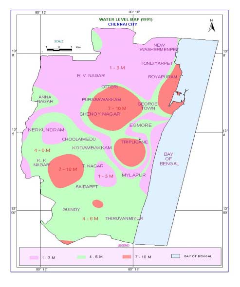
16 the major groundwater extraction structures almost vanished from madras landscape, drilling of deeper borewells and frequent borewell failures were the indicators of constant water table depletion. The depletion of water table in coastal areas has resulted in seawater intrusion causing irreparable damage to the coastal aquifers. Borewells drilled in Triplicane, Royapettah, Besant nagar areas has already started yielding brackish water with very high TDS( ppm). In order to get an idea of the change water table in Chennai city, water table maps were prepared using the observation well data for 1991 and 2002 (Refer water level maps of 1991 and 2002). The map prepared for the year 2002 shows the extension of red polygon (ie., depth to water table between 7m and 10m ) extending in all directions with more predominance in north Chennai and coastal areas. GROUNDWATER QUALITY Because of the heterogeneous nature of the formations, quality of groundwater changes both seasonally and depth-wise. This may be due to the depositional environment, pollution and over development of groundwater. Analysis of shallow aquifers in an around Chennai indicates that the groundwater is alkaline in general with PH values ranging from 7.8 to 9.0. Many pockets have high chloride and sulphate making the water unsuitable for drinking purposes. Groundwater quality is good in select pockets like Besant Nagar, Kotturpuram, Annanagar, Kilpauk and parts of Nungambakkam. Excess iron is noticed in a number of pockets like Adyar, Shastri Nagar, K.K. Nagar, Ashok Nagar, Raja Annamalaipuram and Mylapore. The Buckingham canal constructed at sea level for navigation has resulted in seawater intrusion in the freshwater sediments. The intrusion of seawater due to over development of alluvial aquifer system is noticed in north Chennai. Floating lenses of freshwater and brackish water zones were observed in the Thiruvanmiyur Covalam belt, which are the potential freshwater aquifers in dunes. The same is harnessed extensively resulting in local groundwater mining in Besant Nagar, Thiruvanmuyur, Kottivakkam, Neelangarai area and there is a danger of seawater intrusion locally. The presences of number of industrial units in Guindy and Ambattur area and in north Chennai area add to the pollution of groundwater. Generally dilution of groundwater by artificial recharge will help in improving the water quality by reducing the concentration of salts.
17

18
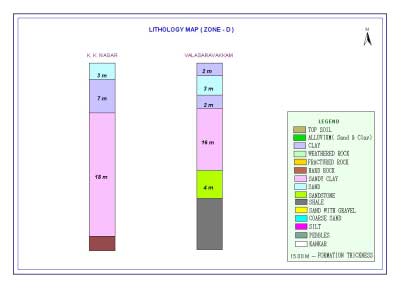
19 RECOMMENDED RWH STRUCTURES FOR GROUNDWATER RECHARGE In the coastal areas and in parts of north Chennai where the top soil is alluvium, shallow recharge wells of 3-4ft in diameter and depth up to 10ft is sufficient to harvest the roof top water. In the hard rock terrain in South Chennai where the top soil is followed by weathered and fractured rock shallow wells of 3-4ft in diameter and depth up to the weathered rock (loose rock) is suitable to harvest the rainwater. An in well bore of 4.5 in diameter drilled in the bottom of the well up to fractured rock (up to 60ft) will increase the water intake capacity of structure. In the Gondwana terrain where the top soil is clayey shallow recharge wells of 3-4ft in diameter and depth up to sandy strata would be ideal. The depth to sandy formation varies from place to place. In Annanagar the depth to alluvium is at around 20ft below ground level. An in well bore well inside the recharge well drilled to the full depth of the sandy bed and provided with slotted casing will facilitate down ward percolation of harvested rainwater. In locations where sufficient space is not available then percolation bore pits can be made. The dimension of the percolation pits should be 2ft x 2ft x 2ft provided with 9 brick work and bottom of the pit left unplastered. A bore of 8 can be drilled inside the pit up to porous formation and provided with slotted PVC casing. The intake capacity of percolation bore pit is much less when compared to recharge wells. In order to get an idea of the depth of porous formation at different location within the city the sub surface lithology for selected locations in given in the lithology map. (Refer Lithology Map and Zonewise Lithology)
20

21
22

23
WILLOCHRA BASIN GROUNDWATER STATUS REPORT 2009-10
 WILLOCHRA BASIN GROUNDWATER STATUS REPORT 2009-10 SUMMARY 2009-10 The Willochra Basin is situated in the southern Flinders Ranges in the Mid-North of South Australia, approximately 50 km east of Port Augusta
Climate change impacts on city of Gdansk and its vicinity (Vistula Delta, Poland)
") Final International ASTRA Conference Espoo, 10-11 December, 2007 Climate change impacts on city of Gdansk and its vicinity (Vistula Delta, Poland) Dorota Kaulbarsz, Zbigniew Kordalski, Wojciech Jeglinski
Final International ASTRA Conference Espoo, 10-11 December, 2007 Climate change impacts on city of Gdansk and its vicinity (Vistula Delta, Poland) Dorota Kaulbarsz, Zbigniew Kordalski, Wojciech Jeglinski
Predicting Seismic Vulnerable Zones using GIS. Outline of the presentation. Objectives. Risk Mapping Overview Factor Maps. Three levels of Zonation
 Predicting Seismic Vulnerable Zones using GIS by K.S.A. Dinesh Kumar Research Scholar, Anna University & Lecturer in Civil Engineering Dept. National Institute of Technical Teachers Training & Research
How To Map A Lake In The North Of The Holland (Fiji)
") 1. Hydrogelogical mapping Jiri Sima Aim of HG map Groundwater and rocks qualitative permeability and quantitative potential of rock units aquifers / aquitards / aquiclides Water points (spatial distribution
1. Hydrogelogical mapping Jiri Sima Aim of HG map Groundwater and rocks qualitative permeability and quantitative potential of rock units aquifers / aquitards / aquiclides Water points (spatial distribution
Ground Water in the Piedmont and Blue Ridge Provinces of North Carolina
 Ground Water in the Piedmont and Blue Ridge Provinces of North Carolina Prepared by: R.L. Huffman Extension Agricultural Engineering Specialist Published by: North Carolina Cooperative Extension Service
BENIN SUMMARY PROJECT SITE. Methodology
 BENIN SUMMARY PROJECT SITE Methodology Cotonou City whose population was estimated at approximately 700,000 inhabitants according to the general census on population and human settlement conducted in February
Development of Rural Drinking Water Security Plan A Case Study from Raipur Block, Bhilwara District, Rajasthan
 Development of Rural Drinking Water Security Plan A Case Study from Raipur Block, Bhilwara District, Rajasthan Dr. B. K. Bhadra Scientist/Engr. SF Regional Remote Sensing Centre (RRSC-W) NRSC/ISRO, Dept.
CHAPTER - X WATER HARVERSTING AND RECHARGING IN HARD ROCK AREAS
 CHAPTER - X WATER HARVERSTING AND RECHARGING IN HARD ROCK AREAS CHAPTER X WATER HARVERSTING AND RECHARGING IN HARD ROCK AREAS 10.0 CONCEPTUAL FRAME WORK From a technical stand point, though hard rock areas
Chapter 9: Water, Hydrology and Drainage Land West of Uttoxeter
 Chapter 9: Water, Hydrology and Drainage Land West of Uttoxeter ENVIRONMENTAL STATEMENT: VOLUME 1 9.1 INTRODUCTION 9.1.1 This Chapter considers the effects of the Project on surface water and groundwater
How To Prepare A Geotechnical Study For A Trunk Sewer Project In Lincoln, Nebraska
 APPENDIX B Geotechnical Engineering Report GEOTECHNICAL ENGINEERING REPORT Preliminary Geotechnical Study Upper Southeast Salt Creek Sanitary Trunk Sewer Lincoln Wastewater System Lincoln, Nebraska PREPARED
GROUND WATER INFORMATION BOOKLET CHITRADURGA DISTRICT, KARNATAKA
 GOVERNMENT OF INDIA MINISTRY OF WATER RESOURCES CENTRAL GROUND WATER BOARD GROUND WATER INFORMATION BOOKLET CHITRADURGA DISTRICT, KARNATAKA MOLAKALMURU CHITRADURGA CHALLAKERE HOLALKERE HIRIYUR HOSDURGA
Dr S.K. GUPTA Scientist D Central Ground Water Board. 25 th FEB. 2014
 GROUND WATER SCENARIO AND MANAGEMENT OPNTIONS IN NCR, DELHI Dr S.K. GUPTA Scientist D Central Ground Water Board 25 th FEB. 2014 National Capital Region, Delhi National Capital Region Sl No State District
WEATHERING, EROSION, AND DEPOSITION PRACTICE TEST. Which graph best shows the relative stream velocities across the stream from A to B?
 NAME DATE WEATHERING, EROSION, AND DEPOSITION PRACTICE TEST 1. The diagram below shows a meandering stream. Measurements of stream velocity were taken along straight line AB. Which graph best shows the
AADHAR CENTRE DETAILS
 1 Zonal Office, Zone 1 TH Road, Thiruvottiyur, Chennai 19 Asst. Exe. Engineer. Junior Engineer. Unit- 3 9445190103 2 Zone 1 Tiruvottiyur Division Office, Zone 1, Ward 2 Ennore, Chennai 57 Asst. Exe. Engineer.,
PRSENTATION ON DRAINAGE SYSTEM DELHI 25.07.2014 EAST DELHI MUNICIPAL CORPORATION
 PRSENTATION ON DRAINAGE SYSTEM OF DELHI EAST DELHI MUNICIPAL CORPORATION 25.07.2014 MAP OF DELHI SHOWING MCD s, NDMC & DCB ABOUT DELHI DELHI MANIFESTS UNCONTROLLED URBANISATION POPULATION INDUSTRIALISATION
Vulnerability Assessment
 Vulnerability Assessment VULNERABILITY As used in this report, vulnerability refers to the sensitivity of groundwater to contamination, and is determined by intrinsic characteristics of the aquifer. It
Groundwater Flooding: a UK Perspective
 Groundwater Flooding: a UK Perspective David Macdonald British Geological Survey Maclean Building Crowmarsh Gifford Wallingford OX10 8BB Tel 01491 838800 NERC All rights reserved Talk outline Definition
Earth Science. River Systems and Landforms GEOGRAPHY 1710. The Hydrologic Cycle. Introduction. Running Water. Chapter 14.
 Earth Science GEOGRAPHY 1710 River Systems and Landforms DAVID R. SALLEE Robert W. Christopherson Charlie Thomsen Chapter 14 Introduction Rivers and streams are dynamic systems that continually adjust
Course Plan Day 1: Introduction and Overview Hydrology & Fluvial Geomorphology Day 2: Fieldwork on the Braid Burn Alan Jones
 Course Plan Day 1: Introduction and Overview Hydrology & Fluvial Geomorphology Alan Jones E:mail: Alan.Jones@ed.ac.uk Water cycle Globally & Locally River shapes and forms River behaviour Closer look at
MCLAREN VALE PWA GROUNDWATER LEVEL AND SALINITY STATUS REPORT 2009 10
 MCLAREN VALE PWA GROUNDWATER LEVEL AND SALINITY STATUS REPORT 2009 10 SUMMARY 2009 10 The McLaren Vale PWA is located approximately 35 km south of Adelaide. It is a regional-scale resource for which groundwater
Flash Flood Science. Chapter 2. What Is in This Chapter? Flash Flood Processes
 Chapter 2 Flash Flood Science A flash flood is generally defined as a rapid onset flood of short duration with a relatively high peak discharge (World Meteorological Organization). The American Meteorological
All sediments have a source or provenance, a place or number of places of origin where they were produced.
 Sedimentary Rocks, Processes, and Environments Sediments are loose grains and chemical residues of earth materials, which include things such as rock fragments, mineral grains, part of plants or animals,
7) A clastic sedimentary rock composed of rounded to subrounded gravel is called a A) coal. B) shale. C) breccia.
 A clastic sedimentary rock composed of rounded to subrounded gravel is called a A) coal. B) shale. C) breccia.") Please read chapters 10 and 5 CHAPTER 5 Sedimentary Rocks 1) Sedimentary rocks A) form by compaction and cementation of loose sediment. B) are widespread on the continents and ocean floor. C) are common
Please read chapters 10 and 5 CHAPTER 5 Sedimentary Rocks 1) Sedimentary rocks A) form by compaction and cementation of loose sediment. B) are widespread on the continents and ocean floor. C) are common
4 Water supply description
 4 Water supply description A description of the drinking-water system is equally applicable to large utilities with piped distribution systems, piped and non-piped community supplies, including handpumps
Catchment Scale Processes and River Restoration. Dr Jenny Mant Jenny@therrc.co.uk. The River Restoration Centre therrc.co.uk
 Catchment Scale Processes and River Restoration Dr Jenny Mant Jenny@therrc.co.uk The River Restoration Centre therrc.co.uk 3 Main Catchment Elements Hydrology Energy associated with the flow of water affects
Watershed Works Manual
 National Rural Employment Guarantee Act Watershed Works Manual DRAINAGE LINE TREATMENT: GABION STRUCTURE Baba Amte Centre for People s Empowerment Samaj Pragati Sahayog September 2006 Drainage Line Treatment:
Chennai, India - ACWW Triennial Conference September 26 -October 2 2013
 Chennai, India nd Chennai, India - ACWW Triennial Conference September 26 -October 2 2013 The Society of Daughters Mary Immaculate and collaboration (DMI) is an apostolic life for women. DMI was founded
Influence of various factors on the fluctuation of groundwater level in hard rock terrain and its importance in the assessment of groundwater
 Journal of Geology and Mining Research Vol. 3(11) pp. 305-317, November 2011 Available online at http://www.academicjournals.org/jgmr ISSN 2006-9766 2011 Academic Journals Full Length Research Paper Influence
FLOOD RISK ASSESSMENT AND DRAINAGE STRATEGY
 FLOOD RISK ASSESSMENT AND DRAINAGE STRATEGY London Rd. WATERLOOVILE FOR McCarthy & Stone Ltd. July 2010 Such Salinger Peters Ltd 30558-1- Flood Risk Assessment & Drainage Strategy Contents Paragraph Page
Water Resources Development and Management in India - An Overview
 Water Resources Development and Management in India - An Overview A presentation by U. N. Panjiar Secretary to the Government of India This presentation Water resources scenario in India Water governance
EXPLAINING GROUNDWATER AND WATER WELLS
 EXPLAINING GROUNDWATER AND WATER WELLS This document aims to provide a non-technical description of groundwater: how it occurs, how it moves underground, and the basic principles behind constructing and
WATER CONSERVATION TECHNICAL BRIEFS
 WATER CONSERVATION TECHNICAL BRIEFS TB 2 Rainwater Harvesting and Artificial Recharge to Groundwater SAI Platform August 2009 This document has been produced for internal information purposes only among
Deserts, Wind Erosion and Deposition
 Deserts, Wind Erosion and Deposition By definition, a desert has less than 10 in (25 cm) of precipitation per year. Deserts occur at 30 o and 60 o in regions of descending air. Deserts can be hot or cold.
Hydrogeology Experiment on Surface-Groundwater Interactions: How Do Our Actions Affect Water Quantity and Quality?
 Name: Period: Hydrogeology Experiment on Surface-Groundwater Interactions: How Do Our Actions Affect Water Quantity and Quality? Purpose/Objective: Students will learn how groundcover influences surface
Proposed Construction of Basement Flood Risk Assessment. 35 Edwardes Square London W8 6HH
 Proposed Construction of Basement Flood Risk Assessment 35 Edwardes Square London W8 6HH 1 Introduction This FRA has been carried out in accordance with the National Planning Policy Statement (NPPF), the
APPENDIX F. RESIDENTIAL WATER QUALITY PLAN: ALLOWABLE BMP OPTIONS
 APPENDIX F. RESIDENTIAL WATER QUALITY PLAN: ALLOWABLE BMP OPTIONS The following section provides descriptions, advantages, limitations, and schematics of allowable best management practices (BMPs) for
How Did These Ocean Features and Continental Margins Form?
 298 10.14 INVESTIGATION How Did These Ocean Features and Continental Margins Form? The terrain below contains various features on the seafloor, as well as parts of three continents. Some general observations
NATURAL RESOURCES & NATURAL FEATURES
 A3 NATURAL RESOURCES & NATURAL FEATURES INTRODUCTION This chapter will discuss the topography, geology, soils, and other natural features found in Casco Township. The identification of the natural features
THE ECOSYSTEM - Biomes
 Biomes The Ecosystem - Biomes Side 2 THE ECOSYSTEM - Biomes By the end of this topic you should be able to:- SYLLABUS STATEMENT ASSESSMENT STATEMENT CHECK NOTES 2.4 BIOMES 2.4.1 Define the term biome.
6. Base your answer to the following question on the graph below, which shows the average monthly temperature of two cities A and B.
 1. Which single factor generally has the greatest effect on the climate of an area on the Earth's surface? 1) the distance from the Equator 2) the extent of vegetative cover 3) the degrees of longitude
Global Water Resources
 Global Water Resources Highlights from assessment activities over the past two decades, which are used to establish present and future water trends, reveal that: 1. Freshwater resources are unevenly distributed,
Chapter 18 Introduction to. A f r i c a
 Chapter 18 Introduction to A f r i c a Ch. 18:1 Landforms & Resources 1. Africa s shape & landforms are the result of its location in the southern part of the ancient supercontinent of. Pangaea Over thousands
Ground-Water-Level Monitoring and the Importance of Long-Term Water-Level Data U.S. Geological Survey Circular 1217
 Ground-Water-Level Monitoring and the Importance of Long-Term Water-Level Data U.S. Geological Survey Circular 1217 by Charles J. Taylor William M. Alley Denver, Colorado 2001 U.S. DEPARTMENT OF THE INTERIOR
Settlement of Foundations on Expansive Clays Due to Moisture Demand of Trees CIGMAT 2008
 Settlement of Foundations on Expansive Clays Due to Moisture Demand of Trees CIGMAT 2008 Kenneth E. Tand, P.E. Practicing Geotechnical Engineer FRIEND OR FOE Trees are our friends. They extract carbon
Pre- FEASIBILITY REPORT
 Pre- FEASIBILITY REPORT In Respect Of JHILIMINDA SAND BED OVER 20.30 ACRES OR 8.215 HA IN VILLAGE JHILIMINDA, ATTABIRA TAHASIL OF BARGARH DISTRICT, ODISHA (For the Financial Year-2015-16 to 2019-20) Prepared
GLOSSARY OF TERMS CHAPTER 11 WORD DEFINITION SOURCE. Leopold
 CHAPTER 11 GLOSSARY OF TERMS Active Channel The channel that contains the discharge Leopold where channel maintenance is most effective, sediment are actively transported and deposited, and that are capable
Geography Gr 10 to Gr 12
 Gr 10 to Gr 12 From Grade 10 to Grade 12 the subject of is offered in The NSC stream at the DSJ. In this regard the school has to follow the requirements and syllabii of the CAPS document for as set out
Rocks & Minerals. 10. Which rock type is most likely to be monomineralic? 1) rock salt 3) basalt 2) rhyolite 4) conglomerate
 rock salt 3) basalt 2) rhyolite 4) conglomerate") 1. Of the Earth's more than 2,000 identified minerals, only a small number are commonly found in rocks. This fact indicates that most 1) minerals weather before they can be identified 2) minerals have
1. Of the Earth's more than 2,000 identified minerals, only a small number are commonly found in rocks. This fact indicates that most 1) minerals weather before they can be identified 2) minerals have
NJ650.1404 Interception Drainage
 NJ650.1404 Interception Drainage Interception drainage is used to intercept surface and subsurface water. The investigation, planning, and construction of surface interception drains follow the requirements
Georgia Performance Standards Framework for Science Grade 6. Unit Organizer: Water in Earth s Processes. (Approximate Time: 5-6 Weeks)
") The following instructional plan is part of a GaDOE collection of Unit Frameworks, Performance Tasks, examples of Student Work, and Teacher Commentary. Many more GaDOE approved instructional plans are
The following instructional plan is part of a GaDOE collection of Unit Frameworks, Performance Tasks, examples of Student Work, and Teacher Commentary. Many more GaDOE approved instructional plans are
SOAK UP YOUR STORMWATER
 SOAK UP YOUR STORMWATER This booklet explains how you can apply soakage on your property to achieve efficient disposal of stormwater. The following information on soakage is intended as a guide only. All
DOÑA ANA COUNTY DESIGN STORM CRITERIA GUIDELINES FOR COMMERCIAL AND RESIDENTIAL SITES. Run-off Analysis Methods
 DOÑA ANA COUNTY DESIGN STORM CRITERIA GUIDELINES FOR COMMERCIAL AND RESIDENTIAL SITES Run-off Analysis Methods This document sets forth the minimum design, technical criteria and specifications for the
< SUBSURFACE DAMS TO AUGMENT GROUNDWATER STORAGE IN BASEMENT TERRAIN FOR HUMAN SUBSISTENCE BRAZILIAN EXPERIENCE >
 CASE PROFILE COLLECTION No 5 < SUBSURFACE DAMS TO AUGMENT GROUNDWATER STORAGE IN BASEMENT TERRAIN FOR HUMAN SUBSISTENCE BRAZILIAN EXPERIENCE > Stephen Foster September 2002 TASK MANAGERS: Gabriel Azevedo
APPLICATION OF GEOSPATIAL TECHNOLOGIES FOR SUSTAINABLE ENVIRONMENTAL MANAGEMENT
 APPLICATION OF GEOSPATIAL TECHNOLOGIES FOR SUSTAINABLE NATURAL RESOURCES AND ENVIRONMENTAL MANAGEMENT IN MALAYSIA By James Dawos Mamit, Ph.D. Deputy Minister Ministry of Natural Resources and Environment,
Review of Groundwater Vulnerability Assessment Methods Unsaturated Zone. Dept. of Earth Sciences University of the Western Cape
 Review of Groundwater Vulnerability Assessment Methods Unsaturated Zone Dept. of Earth Sciences University of the Western Cape Background Sililo et al. (2001) Groundwater contamination depends on: Intrinsic
RESTORATION AND ENHANCEMENT OF SOUTHERN CALIFORNIA LAGOONS
 RESTORATION AND ENHANCEMENT OF SOUTHERN CALIFORNIA LAGOONS by Hany Elwany, Ph.D. Scripps Institution of Oceanography Headwaters to Oceans Conference 25 October 2003 CE Ref #03-22 San Diego County Lagoons
Pre- FEASIBILITY REPORT
 Pre- FEASIBILITY REPORT In Respect Of SRIPURA SAND BED-BOVER 35.25 ACRES OR 14.265 HA IN VILLAGE SRIPURA, JHARSUGUDA TAHASIL OF JHARSUGUDA DISTRICT, ODISHA (For the Financial Year-2015-16 to 2019-20) Prepared
Guidelines For Sealing Groundwater Wells
 Guidelines For Sealing Groundwater Wells Government of Newfoundland and Labrador Department of Environment and Conservation Water Resources Management Division Government of Newfoundland and Labrador Department
Water & Climate Review
 Water & Climate Review 1. The cross section below shows the direction of air flowing over a mountain. Points A and B are at the same elevation on opposite sides of the mountain. 4. The graph below shows
(http://www.molevalley.gov.uk/media/pdf/c/r/srfa_-_updated_jnauary_2012.pdf
 Possible Submission about Water and Flooding (See maps 3a and 3b) From Mole Valley Local Development Framework: Strategic Flood Risk Assessment Update 2012 (http://www.molevalley.gov.uk/media/pdf/c/r/srfa_-_updated_jnauary_2012.pdf
SUSTAINABLE URBAN DRAINAGE SYSTEMS
 overflow can lead into a permeable conveyance system to increase further the benefit and reduce the need for pipe systems. Pollutant removal rates have been shown to be high, with some pollutants being
SLOPE AND TOPOGRAPHY
 SLOPE AND TOPOGRAPHY What are Slope and Topography? Slope and topography describe the shape and relief of the land. Topography is a measurement of elevation, and slope is the percent change in that elevation
1. Michigan Geological History Presentation (Michigan Natural Resources)
") 1. Michigan Geological History Presentation (Michigan Natural Resources) The Michigan Geological History Presentation provides an overview of the approximately 3 billion years of Earth Processes that the
1. Michigan Geological History Presentation (Michigan Natural Resources) The Michigan Geological History Presentation provides an overview of the approximately 3 billion years of Earth Processes that the
INFORMATION SHEET ORDER NO. R5-2011-XXXX TRIANGLE ROCK PRODUCTS, INC. FLORIN ROAD AGGREGATE PLANT SACRAMENTO COUNTY
 ORDER NO. R5-2011-XXXX INFORMATION SHEET Background Triangle Rock, Inc. (Discharger) submitted a Report of Waste Discharge (RWD) on 23 August 2010. The Discharger is expanding the mining operations at
Chapter 2 Brief Overview of the Yamuna River Basin and Issues
 Chapter 2 Brief Overview of the Yamuna River Basin and Issues Abstract This chapter presents the current status of the Yamuna river basin as well as brief description of its catchments. This chapter also
COCHIN CITY PROFILE. 1. Location and Regional Setting
 COCHIN CITY PROFILE 1. Location and Regional Setting Cochin City is in the Ernakulam District of Kerala, the state formed by the merger of the former kingdoms of Travancore, Cochin and Malabar (which was
CHAPTER - VI FLOOD DAMAGES
 CHAPTER - VI FLOOD DAMAGES 6.1 General Generally flood is defined as an unusually high stage in a river normally the level at which the river overflows its banks and inundates the adjoining area. In other
Climate, Vegetation, and Landforms
 Climate, Vegetation, and Landforms Definitions Climate is the average weather of a place over many years Geographers discuss five broad types of climates Moderate, dry, tropical, continental, polar Vegetation:
Geologic History Review
 1. The climate that existed in an area during the early Paleozoic Era can best be determined by studying (1) the present climate of the area (2) recorded climate data of the area since 1700 (3) present
Responding to the challenges
 WATER PROOFING THE WEST STAGE ONE MOVING TOWARDS A WATER SENSITIVE CITY Adrian Sykes Strategic Infrastructure Executive Officer, City of Charles Sturt Woodville, Adelaide, South Australia Abstract This
Basic Soil Erosion and Types
 Basic Soil Erosion and Types 2015 Wisconsin Lakes Convention Stacy Dehne DATCP Engineer Types of Soil Erosion Rain drop or splash erosion: Erosion preceded by the destruction of the crumb structure due
Lars-Göran Gustafsson, DHI Water and Environment, Box 3287, S-350 53 Växjö, Sweden
 Alternative Drainage Schemes for Reduction of Inflow/Infiltration - Prediction and Follow-Up of Effects with the Aid of an Integrated Sewer/Aquifer Model Introduction Lars-Göran Gustafsson, DHI Water and
High-resolution seismic reflection to image hydrogeologic sequences Richard D. Miller* and Jianghai Xia, Kansas Geological Survey
 Richard D. Miller* and Jianghai Xia, Kansas Geological Survey Introduction High-resolution seismic reflection has been successfully used to delineate preferential pathways within groundwater systems that
Description of Simandou Archaeological Potential Model. 13A.1 Overview
 13A Description of Simandou Archaeological Potential Model 13A.1 Overview The most accurate and reliable way of establishing archaeological baseline conditions in an area is by conventional methods of
2. PRE-FEASIBILITY REPORT
 2. PRE-FEASIBILITY REPORT 2.1 Executive Summary The proposed project is Building stone quarry having lease area of 1.214 ha and falls under Category- A as per EIA Notification 2006 and its amendments of
PRESENTATION. Improving the performance of Public Water Utilities A case study of Bangalore N.C. MUNIYAPPA, Chairman, BWSSB LOCATION MAP OF BANGALORE
 Arabian Sea Mumbai KARNATAKA Delhi Chennai Nepal Calcutta Bay of Bengal PRESENTATION Improving the performance of Public Water Utilities A case study of Bangalore By N.C. MUNIYAPPA, Chairman, BWSSB LOCATION
Ground Water Surveys and Investigation
 Ground Water Surveys and Investigation By Gautam Mahajan ASHISH PUBLISHING HOUSE 8/81, PUNJABI BAGH, NEW DELHI-110 026 - Contents Preface List of Abbrivations (v) (vii) 1.1 1.2 1.3 1.4 1.5 1.6 1.7 1.7.1
River Basin Management in Croatia
 River Basin Management in Croatia 2. INTERNATIONAL RIVER BASIN MANAGEMENT HIGH LEVEL SYMPOSIUM Cappadocia/NEVŞEHİR, Turkey 16-18 April 2013 2 Water sector responsibilities are shared among: Croatian Parliament
Geotechnical Investigation using Standard Penetration Test (SPT) in Rangamati, Bandarban and Khagrachari Towns
 in Rangamati, Bandarban and Khagrachari Towns") 1. Introduction 1.1 Scope of Work The Asian Disaster Preparedness Centre (ADPC) is implementing the project Seismic Hazard and Vulnerability Mapping for Rangamati, Bandarban and Khagrachari Municipality.
1. Introduction 1.1 Scope of Work The Asian Disaster Preparedness Centre (ADPC) is implementing the project Seismic Hazard and Vulnerability Mapping for Rangamati, Bandarban and Khagrachari Municipality.
2. PRE-FEASIBILITY REPORT
 2. PRE-FEASIBILITY REPORT 2.1 Executive Summary The proposed project is Building stone quarry having lease area of 0.809 ha and falls under Category- A as per EIA Notification 2006 and its amendments of
NAJAFGARH DRAIN-SAMPLING AND ANALYSIS
 Dr. Anamika Paul* Preeti Jain* Kartikey Handa* NAJAFGARH DRAIN-SAMPLING AND ANALYSIS Abstract: Over the past years, due to rapid industrialization and advanced agricultural activities environmental deterioration
WEST LONDON PIPELINE AND STORAGE LIMITED AND UNITED KINGDOM OIL PIPELINES LIMITED
 WEST LONDON PIPELINE AND STORAGE LIMITED AND UNITED KINGDOM OIL PIPELINES LIMITED WLPS BUNCEFIELD REBUILD Flood Risk Assessment Green Lane Hemel Hempstead Hertfordshire HP2 7HZ September 2009 Prepared
Agricultural & Farm Development - The Planning Issues
 Agricultural & Farm Development - The Planning Issues Generally, smaller developments of an agricultural or forestry nature are exempt, however, larger developments do require planning permission. In addition,
SOUTHWEST FLORIDA WATER MANAGEMENT DISTRICT RESOURCE REGULATION TRAINING MEMORANDUM
 SOUTHWEST FLORIDA WATER MANAGEMENT DISTRICT RESOURCE REGULATION TRAINING MEMORANDUM DATE: December 04, 1996 This document is subject to change. If in doubt, verify current status with Technical Services
Chapter 3 Communities, Biomes, and Ecosystems
 Communities, Biomes, and Ecosystems Section 1: Community Ecology Section 2: Terrestrial Biomes Section 3: Aquatic Ecosystems Click on a lesson name to select. 3.1 Community Ecology Communities A biological
P02 Calibration of Density Driven Flow Model for the Freshwater Lens beneath the North Sea Island Borkum by Geophysical Data
 P02 Calibration of Density Driven Flow Model for the Freshwater Lens beneath the North Sea Island Borkum by Geophysical Data H. Sulzbacher (LIAG), H. Wiederhold* (LIAG), M. Grinat (LIAG), J. Igel (LIAG),
Hardness Comparisons
 Hardness Comparisons Hardness Adapted from: An original Creek Connections activity. Creek Connections, Box 10, Allegheny College, Meadville, Pennsylvania 16335. Grade Level: all Duration: 50 minutes Setting:
NUMERICAL ANALYSIS OF SEEPAGE THROUGH EMBANKMENT DAMS (CASE STUDY: KOCHARY DAM, GOLPAYEGAN)
") NUMERICAL ANALYSIS OF SEEPAGE THROUGH EMBANKMENT DAMS (CASE STUDY: KOCHARY DAM, GOLPAYEGAN) *Reza Naghmehkhan Dahande 1 and Ahmad Taheri 2 1 Department of Civil Engineering-Water Management, Islamic Azad
NUMERICAL ANALYSIS OF SEEPAGE THROUGH EMBANKMENT DAMS (CASE STUDY: KOCHARY DAM, GOLPAYEGAN) *Reza Naghmehkhan Dahande 1 and Ahmad Taheri 2 1 Department of Civil Engineering-Water Management, Islamic Azad
1 in 30 year 1 in 75 year 1 in 100 year 1 in 100 year plus climate change (+30%) 1 in 200 year
 1 in 200 year") Appendix C1 Surface Water Modelling 1 Overview 1.1 The Drain London modelling was designed to analyse the impact of heavy rainfall events across each London borough by assessing flow paths, velocities
Appendix C1 Surface Water Modelling 1 Overview 1.1 The Drain London modelling was designed to analyse the impact of heavy rainfall events across each London borough by assessing flow paths, velocities
DESCRIPTION OF STORMWATER STRUCTURAL CONTROLS IN MS4 PERMITS
 DESCRIPTION OF STORMWATER STRUCTURAL CONTROLS IN MS4 PERMITS Phase I MS4 permits require continuous updating of the stormwater system inventory owned and operated by the MS4. They also include inspection
FREDERICK SHERRELL LTD
 FREDERICK SHERRELL LTD CONSULTING ENGINEERING GEOLOGISTS AND GEOTECHNICAL ENGINEERS 66 WEST STREET TAVISTOCK DEVON PL19 8AJ Your Ref: Our Ref: 2962.NS.JR Telephone: 01822 612915 Facsimile: 01822 617394
Basements and Deep Building Construction Policy 2014
 Basements and Deep Building Construction Policy 2014 APPROVAL Council / CEO 27 October 2014 VERSION NO: Version 1.0 TRIM REF: 14/67838 REVIEW 30/10/2019 RESPONSIBLE EXECUTIVE General Manager City Assets
8 Spring water tapping. Andrew Tayong
 8 Spring water tapping Andrew Tayong 8 Spring water tapping 8.1 Introduction Springs are found mainly in mountainous or hilly ter-rain. A spring may be defined as a place where a na-tural outflow of groundwater
Groundwater Potential of Basement Aquifers in Part of Southwestern Nigeria
 American International Journal of Contemporary Research Vol. 3 No. 3; March 2013 Groundwater Potential of Basement Aquifers in Part of Southwestern Nigeria Yinusa Ayodele Asiwaju-Bello Department of Marine
What are the controls for calcium carbonate distribution in marine sediments?
 Lecture 14 Marine Sediments (1) The CCD is: (a) the depth at which no carbonate secreting organisms can live (b) the depth at which seawater is supersaturated with respect to calcite (c) the depth at which
Climate Change and Infrastructure Planning Ahead
 Climate Change and Infrastructure Planning Ahead Climate Change and Infrastructure Planning Ahead Infrastructure the physical facilities that support our society, such as buildings, roads, railways, ports
UNIT I INTRODUCTION. This unit deals with Location space relations and India s place in the world
 UNIT I INTRODUCTION This unit deals with Location space relations and India s place in the world CHAPTER INDIA LOCATION You have already seen the map of India in the previous classes. Now you closely examine
Outlet stabilization structure
 Overview of Sedimentation and Erosion Control Practices Practice no. 6.41 Outlet stabilization structure Erosion at the outlet of channels, culverts, and other structures is common, and can cause structural
BASIN MANAGEMENT OBJECTIVES CHEROKEE SUBINVENTORY UNIT
 BASIN MANAGEMENT OBJECTIVES CHEROKEE SUBINVENTORY UNIT Butte County Water Advisory Committee Member John Scott Contact Information Phone Number: (530) 533-8394 Email Address: john_lewis_scott@msn.com Description
Chippenham Surface Water Management Plan Intermediate Assessment of Groundwater Flooding Susceptibility
 Chippenham Surface Water Management Plan Intermediate Assessment of Groundwater Flooding Susceptibility Phase 1 & 2 November 2011 Prepared for Revision Schedule Surface Water Management Plan Intermediate