FLOOD RISK ASSESSMENT AND DRAINAGE STRATEGY
|
|
|
- Russell Lane
- 9 years ago
- Views:
Transcription
1 FLOOD RISK ASSESSMENT AND DRAINAGE STRATEGY London Rd. WATERLOOVILE FOR McCarthy & Stone Ltd. July 2010 Such Salinger Peters Ltd

2 Flood Risk Assessment & Drainage Strategy Contents Paragraph Page 1. Introduction 3 2. Topography 3 3. Watercourses, Flood Levels & Flood Risk 3 4. Emergency Access Route 4 5. Foul Water Drainage 4 6. Surface Water Drainage 5 7. Flood Defence Consent 5 8. Code for Sustainable Housing 5 9. Conclusions & Recommendations 6 Appendices Appendix 1 Topographic Survey and Sewer Record Appendix 2 - Photographs Appendix 3 Site Plan Appendix 4 Environment Agency Pro-Forma

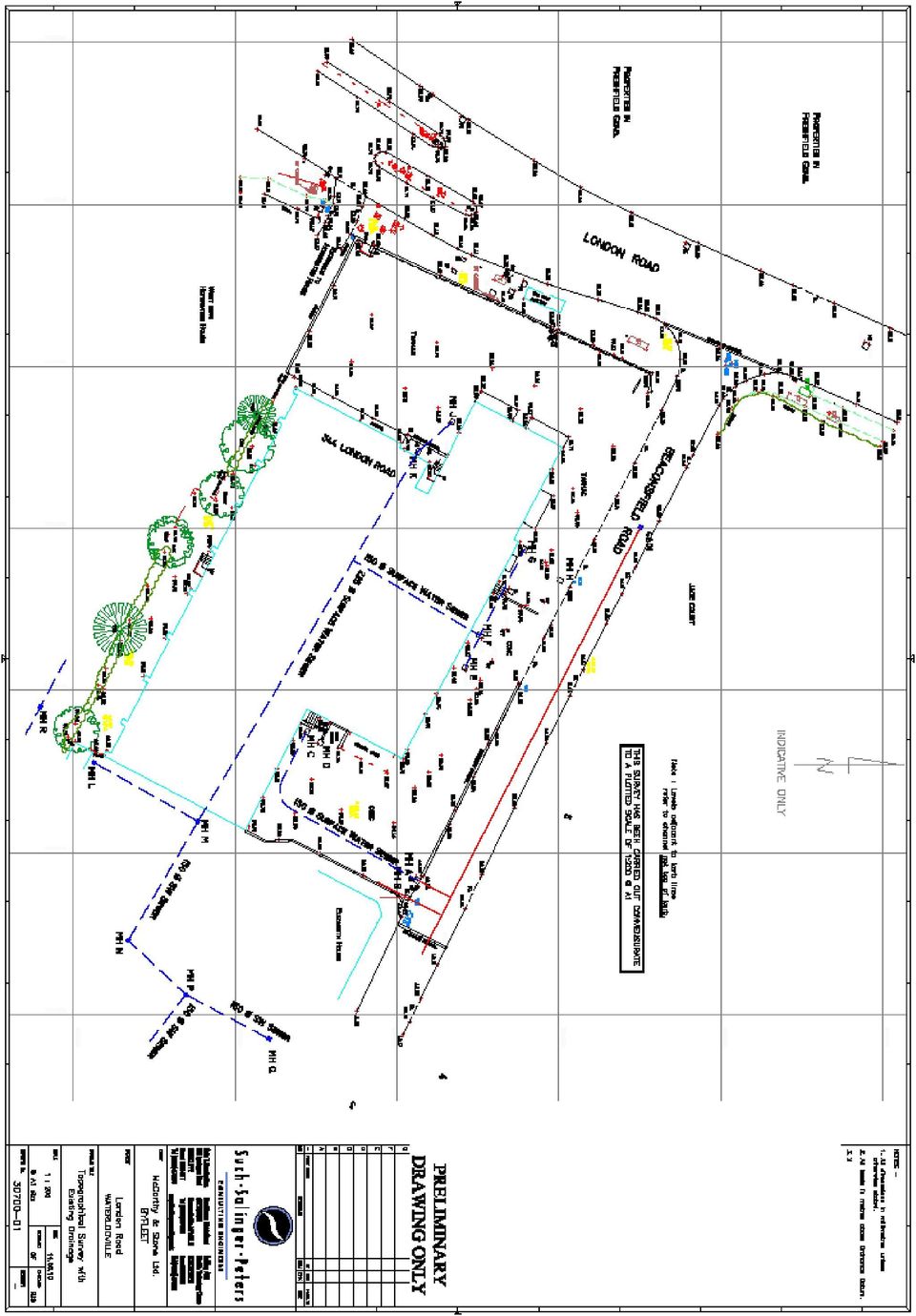
3 Flood Risk Assessment & Drainage Strategy 344 London Road, WATERLOOVILLE 1. Introduction: 1.1 Such Salinger Peters have been instructed to produce a site specific Flood Risk Assessment (FRA) for the proposed redevelopment of this site. This report has been prepared in accordance with Planning Policy Statement 25: Development & Flood Risk (PPS25). 1.2 The site lies in the centre of Waterlooville with a frontage onto London Road (A3). It currently comprises a Jewsons retail depot. 1.3 The proposal is to develop the site with a block of 38 Cat II Retirement Flats for the elderly. 1.4 The flood mapping published by the Environment Agency (EA) and also in the Partnership for Urban South Hampshire (PUSH) Strategic Flood Risk Assessment (SFRA) shows the site to lie in Zone 1 outside the 1 in 1000 year tidal and fluvial flood zones even when the possible impact of climate change is taken into account. 1.5 We have included the following information in this report: A topographic survey to Ordnance Datum. An assessment of possible sources of flooding. A strategy for foul and surface water drainage. A standard Environmental Agency flood risk pro-forma is attached in Appendix 3 2. Topography: 2.1 The site has been surveyed to Ordnance Datum based on GPS and shows that the site has a fall from west to east of approximately 2.8m. 2.2 A topographic survey of the site is attached to this report in Appendix The site is bounded to the north by Beaconsfield Road where the existing main site entrance is located. To the east of the site is a block of flats called Elizabeth House and to the west is London Road, a main thoroughfare (A3). South of the site is a previous McCarthy and Stone development, Homewater House. 3. Watercourses, Flood levels & Flood Risk: 3.1 E.A. flood mapping from their website, supported by the PUSH SFRA shows the site to be in Zone 1 with a Low Probability of flooding. The nearest watercourse is 250m to the east of the site 3.2 The Strategic FRA has no reports of flood incidents in this area. 3.3 Possible sources of flood risk are as follows:

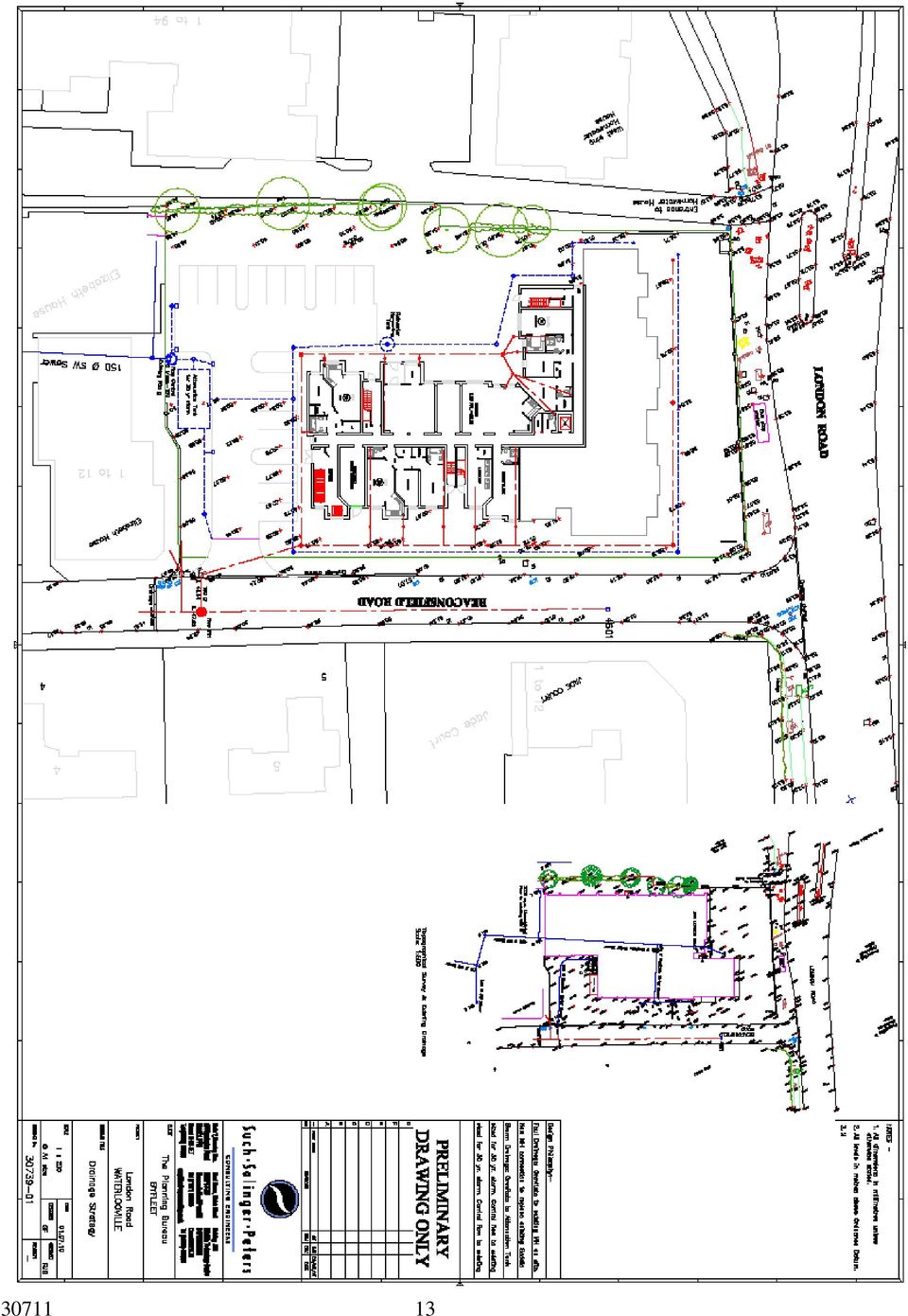
4 A Surface Water: Flooding from Surface Water would take the form of excess runoff from impermeable areas. There are no separate surface water sewers in London or Beaconsfield Road. Beaconsfield Road is a cul-de-sac and falls approx 3.75m away from the junction with London Road. A drainage channel at the junction prevents runoff from London Road entering the cul-de-sac. There are a further two drainage channels at the end of the road to capture highway run-off. The front gardens of Nos. 2 & 3 Beaconsfield Rd. are laid with gravel and a gully is seen outside No. 3 indicating that these properties have suffered flooding in the past. The existing Jewsons site was almost 100 % impermeable and run-off from the concrete hard standing would have contributed to the problem, especially if the channels were not regularly maintained. The proposed Finished Floor Level for the lower ground floor of the new building is 50.69m AOD. The lowest site level on Beaconsfield Road is 49.69m AOD so ground water entering the new building is not considered a risk. B C Ground water: Flooding from groundwater could occur if the natural water table rises above ground level. Groundwater was not encountered during the site investigation s exploratory boreholes to a depth of 6.45m. Sewers: Flooding from sewers could occur through blockages, collapse or overloading. Southern Water operates the public foul sewer in Beaconsfield Road and had provided no reports of flooding incidents from local sewers at the time of writing. 3.4 We conclude that there is no significant risk of surface water, groundwater or sewer flooding the building during a 1 in 100 yr. flood event, including an allowance for climate change. 4. Emergency Access Route: 4.1 PPS 25 requires that consideration is given to the access for emergency vehicles during an extreme flood event however in this case we consider the site to be not at risk and have not pursued this issue. 5. Foul Water Drainage: 5.1 The site is served by a 150 Ø public foul sewer in Beconsfield Road, owned and operated by Southern Water. Flows to the sewer from the proposed development will increase by approx. 0.6 l/sec. based on the average occupancy of retirement flats. 5.2 The new building will discharge its foul effluent to the existing on site manhole as shown on drawing A new manhole will be built in the road to replace the existing saddle connection to the public sewer

5 6. Surface Water Drainage: 6.1 The surface water run-off from the proposed development will be designed in accordance with Sustainable Urban Drainage (SUDS) guidelines. Guidelines are published by CIRIA and the EA. 6.2 The existing site has an impermeable area of 3000 m 2 from a total of 3209 m 2 (i.e. 93%) The proposed development reduces the impermeable area to 1557 m 2 (48%). 6.3 The existing site produced a total peak flow of 41.7 l/sec. from a 50mm intensity storm. The surface water drained to a 150 Ø off site sewer and to the road. The slotted concrete drainage channels used on the boundary are not very efficient in heavy storms and it is assumed that this would not have helped the flooding issues at the bottom of the road. This possible issue will be reduced as all rainwater on site will be captured and not allowed to run to the highway. 6.4 A small area of roof drained to a soakaway that had failed and was recorded to be full of water many days after any rainfall. The site investigation records the sub strata as London Clay where soakaways will not be an efficient form of drainage. 6.5 We recommend that a positive drainage system should be designed to deal with a storm of a 1 in 30 year return period, plus an allowance for climate change as per Sewers for Adoption 6 th Edition but with additional storage to cater for a 100 year event by allowing temporary ponding of the car park. 6.6 The discharge will be controlled by reducing the flow to 5 l/sec. and providing an Attenuation Tank to store the excess. Based on calculations for the worst storm scenario (short, sharp summer storm) a storage tank of 24 m 2 is required. This will be placed under the car park as shown on drawing The volume of water discharged will be further reduced by the addition of a rainwater harvesting tank that will allow external water usage for the development. 7. Flood Defence Consent 7.1 The development does not require any works, in or close to a listed water course; therefore Flood Risk Consent is not required. 8.0 Code for Sustainable Housing 8.1 The site lies in Flood Zone 1 and should therefore qualify for two credits under the Code for Sustainable Homes

6 9. Conclusions & Recommendations: 9.1 We have demonstrated that the developed site is in Zone 1 with a low probability of surface water flooding. We have also considered other possible sources of flooding and concluded that the risk is low. 9.2 The foul water drainage from the new development will discharge to the 150 Ø public sewer in Beaconsfield Road owned and operated by Southern Water. 9.3 The new development will have a surface water system designed in accordance with Sustainable Urban Drainage Principles.The solution is likely to include an attenuation tank and a control to 5 l/sec. before draining to the existing surface water sewer running through the site. 9.4 The annual peak surface water flow rate will be reduced from 41.7 l/sec. to 5 l/sec. and the discharge volumes halved. G. Fairbrass

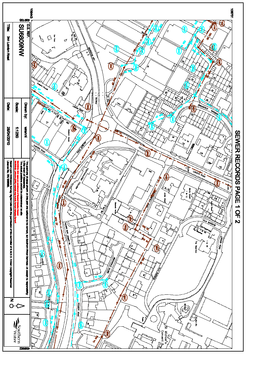
7 Appendix 1 Topographic Survey Sewer Record & EA Map

8
9

10 Appendix 2 Photographs Junction London Rd./ Beaconsfield Rd. showing Drainage Channel Second Channel at lower site boundary

11 Channel between site & highway Failed Soakaway

12 Appendix 3 Site Plan

13
14 Appendix 3 E.A Pro-Forma 1 Development description and location 1a. What type of development is proposed and where will it be located? Retirement Flats in a residential area 1b. What is its vulnerability classification? MORE VULNERABLE 1c. Is the proposed development consistent with the Local Development Documents? YES 1d. Please provide evidence that the Sequential Test or Exception Test has been applied in the selection of this site for this development type? 2. Definition of the flood hazard 2a. What sources of flooding could affect the site? SEE SECTION 3.0 2b. For each identified source, describe how flooding would occur, with reference to any historic records wherever these are available. SEE SECTION 3.0 2c. What are the existing surface water drainage arrangements for the site? Unrestricted run-off to surface water sewer & Highway 3. Probability 3a Which flood zone is the site within? ZONE 1 3b If there is a Strategic Flood Risk Assessment covering this site, what does it show? NO RISK OF FLOODING 3c What is the probability of the site flooding taking account of the contents of the SFRA and of any further sitespecific assessment? LOW 3d What are the existing rates and volumes of run-off generated by the site? 4. Climate change 4a How is flood risk at the site likely to be affected by climate change? NOT APPRECIABLY 5. Detailed development proposals 5a Please provide details of the development layout, referring to the relevant drawings. See appendix 2 5b Where appropriate, demonstrate how land-uses most sensitive to flood damage have been placed in areas within the site that are at least risk of flooding. N/A 6. Flood risk management measures 6a. How will the site be protected from flooding, including the potential impacts of climate change, over the development s lifetime? SUDS SYSTEM TO BE WELL MAINTAINED 7. Off site impacts 7a How will you ensure that your proposed development and the measures to protect your site from flooding will not increase flood risk elsewhere? SURFACE WATER RUN-OFF MANAGED BY SUDS SCHEME 7b How will you prevent run-off from the completed development causing an impact elsewhere? SUDS SCHEME WILL NOT ALLOW ANY SURFACE WATER RUNOFF FROM SITE 8. Residual risks 8a What flood-related risks will remain after you have implemented the measures to protect the site from flooding? NONE 8b How, and by whom, will these risks be managed over the lifetime of the development? N/A

15 Issuing office: Suite 7, Brearley House 278 Lymington Road Highcliffe, Christchurch. Dorset BH23 5ET Other offices at: Moat House Welsh Street Chepstow NP16 5LR and A32 Winfrith Technology Centre Dorchester Dorset DT2 8DH

WEST LONDON PIPELINE AND STORAGE LIMITED AND UNITED KINGDOM OIL PIPELINES LIMITED
 WEST LONDON PIPELINE AND STORAGE LIMITED AND UNITED KINGDOM OIL PIPELINES LIMITED WLPS BUNCEFIELD REBUILD Flood Risk Assessment Green Lane Hemel Hempstead Hertfordshire HP2 7HZ September 2009 Prepared
Development at 2 St Albans Road, Kingston, London, KT25HQ
 Development at SuDS Report. Prepared for: Report prepared by: Dave Alonso Divine Ideas (UK) ltd Date: August 2015 Project/Issue number: Appendices Attached: 1510/01/SuDS A, B & C Divine Ideas (UK) Ltd
Recommendations for future developments
 C Recommendations for future developments C.1 Reducing flood risk through site layout and design C.1.1 C.1.2 Flood risk should be considered at an early stage in deciding the layout and design of a site
Taylor Wimpey UK Ltd. December 2007
 Taylor Wimpey UK Ltd December 2007 QM Issue/revision Issue 1 Revision 1 Revision 2 Revision 3 Remarks Draft For Planning Date 3 August 2007 20 December 2007 Prepared by D Gooding P Barton Signature Checked
Proposed Residential Development Land off Cody Road Waterbeach Cambridgeshire. Flood Risk Assessment
 Land off Cody Road Waterbeach Cambridgeshire Cedar Barn, White Lodge, Walgrave, Northampton, NN6 9PY T: F: E: W: 01604 781811 01604 781999 [email protected] jppuk.net Proposed Residential Development Land
DRAINAGE MANAGEMENT PLAN. HERTFORDSHIRE RESIDUAL WASTE TREATMENT PLANT Hertfordshire County Council
 DRAINAGE MANAGEMENT PLAN HERTFORDSHIRE RESIDUAL WASTE TREATMENT PLANT Hertfordshire County Council EMPLOYER: Veolia Environmental Services (UK) Plc Veolia House 154A Pentonville Road London N1 9PE Copy
Flood Risk Assessment and Drainage Impact Assessment: Planning Guidance for Developers
 Flood Risk Assessment and Drainage Impact Assessment: Planning Guidance for Developers Development and Regeneration Services Glasgow City Council 229 George Street Glasgow G1 1QU May 2011 1. Introduction...-
Chapter 9: Water, Hydrology and Drainage Land West of Uttoxeter
 Chapter 9: Water, Hydrology and Drainage Land West of Uttoxeter ENVIRONMENTAL STATEMENT: VOLUME 1 9.1 INTRODUCTION 9.1.1 This Chapter considers the effects of the Project on surface water and groundwater
Vital Earth Composting Facility Flood Risk and Drainage Statement
 Vital Earth Flood Risk and Drainage Statement Final December 2011 Prepared for Vital Earth Ltd Revision Schedule Flood Risk and Drainage Statement December 2011 Rev Date Details Prepared by Reviewed by
Proposed Re-development, At 321 London Road, Wyberton. Flood Risk Assessment - Revised
 Proposed Re-development, At 321 London Road, Wyberton Flood Risk Assessment - Revised Prepared By: C Mason C.Eng M.I.C.E May 2015 Contents Page No. 1. Introduction 2 2. Site Description 2 3. Flood Hazard
Newbiggin House Farm,
 Newbiggin House Farm, Near Waberthwaite Flood Investigation Report 32 Flood Event 30/8/2012 Cumbria County Council Version Undertaken by Reviewed by Approved by Date Preliminary Colin Parkes Anthony Lane
FLOOD RISK AND SURFACE WATER DRAINAGE ASSESSMENT HILLHOUSE RESTORATION SITE, OFF JAMESON ROAD, THORNTON CLEVELEYS ON BEHALF OF NPL ESTATES
 FLOOD RISK AND SURFACE WATER DRAINAGE ASSESSMENT HILLHOUSE RESTORATION SITE, OFF JAMESON ROAD, THORNTON CLEVELEYS ON BEHALF OF NPL ESTATES Integra Consulting Engineers Limited NS / 2543 Fountain House
Granville Road Estate, London Borough of Barnet. Flood Risk Assessment and Drainage Strategy August 2014. New Granville LLP
 Granville Road Estate, London Borough of Barnet Flood Risk Assessment and Drainage Strategy August 2014 New Granville LLP Document History JOB NUMBER: 237 DOCUMENT REF: Granville Road FRA REVISIONS: Final
London Borough of Waltham Forest LOCAL FLOOD RISK MANAGEMENT STRATEGY. Summary Document
 LOCAL FLOOD RISK MANAGEMENT STRATEGY Summary Document October 2013 Local Flood Risk Management Strategy Summary 1 Introduction 2 Partner responsibilities 3 What do we know about flooding in the borough?
Littleport Co-located Schools
 Littleport Co-located Schools February 2015 Morgan Sindall Littleport Co-located Schools 330763 BNI BSE 003 C P:\Cambridge\Murdoch\EST\PROJECTS\330763 Littleport Co-located Schools\12.0 Documents\12.2
FLOOD RISK RECENT TRENDS AND POLICY RESPONSES
 FLOOD RISK RECENT TRENDS AND POLICY RESPONSES DEVELOPING WESTMINSTER S LOCAL PLAN Booklet No. 2 LDF Consultation - CMP Revision November 2013 INTRODUCTION CLLR ROBERT DAVIS Westminster is at risk of flooding
Planning, Health and Environment Division
 18 Planning, Health and Environment Division A Planning Guide to Sustainable Drainage Systems Introduction Working in co-operation with the Environment Agency, Severn Trent Water Ltd., the Highway Authority
Proposed Construction of Basement Flood Risk Assessment. 35 Edwardes Square London W8 6HH
 Proposed Construction of Basement Flood Risk Assessment 35 Edwardes Square London W8 6HH 1 Introduction This FRA has been carried out in accordance with the National Planning Policy Statement (NPPF), the
East Riding of Yorkshire Council
 East Riding of Yorkshire Council Lead Local Flood Authority Interim Standing Advice Revision A - April 2015 1. Introduction From April 2015 the Lead Local Flood Authority (LLFA) became a statutory consultee
Cambridge House, Henry Street, Bath BA1 1UR
 Flood Risk Assessment Cambridge House, Henry Street, Bath BA1 1UR For Full Planning application to BANES Council June 2011 Introduction This report is prepared as requested by B&NES to accompany the planning
Action plans for hotspot locations - Ash Study
 Appendix 9 Action plans for hotspot locations - Ash Study Ash Vale North 1. Local evidence indicates the culvert could not discharge during December 2013 because the outlet was blocked on the western side
Land to the rear of the Black Bull Public House Flood Risk Assessment March 10, 2014 Version 1.0 Ref: RAB 148
 Land to the rear of the Black Bull Public House Flood Risk Assessment March 10, 2014 Ref: RAB 148 Lindsey Phillips Turnbull Tweedale Ltd 61 Oaken Lanes Codsall South Staffordshire WV8 2AW R A B C O N S
Essex County Council Flood Investigation Report
 Essex County Council Stock City of Chelmsford Rev Date Details Author Checked and Approved By 01 February 2015 Draft report for stakeholder consultation Ed Clarke Flood Investigation Engineer Lucy Shepherd
Pollution Control NEW! NEW! Stormwater Attenuation Systems Sustainable Urban Drainage Solutions for Domestic & Commercial Applications. klargester.
 Pollution Control NEW! NEW! Stormwater Attenuation Systems Sustainable Urban Drainage Solutions for Domestic & Commercial Applications klargester.com Stormwater Attenuation Systems Sustainable Urban Drainage
Bolton s Flood Risk Management Strategy
 Bolton s Flood Risk Management Strategy www.bolton.gov.uk Public Summary Bolton s Flood Risk Management Strategy Public Summary Introduction Over 5.5 million properties in England and Wales are at risk
Introduction. The vision of the West Yorkshire Combined Authority (WYCA) Flood Risk Partnership
 Flood Risk Partnership") WYCA SuDS Guidance Introduction As part of the government s continuing commitment to protect people and property from flood risk, the Department for Communities and Local Government and the Department
WYCA SuDS Guidance Introduction As part of the government s continuing commitment to protect people and property from flood risk, the Department for Communities and Local Government and the Department
Strategic Flood Risk Assessment Update 2015
 Strategic Flood Risk Assessment Update 2015 On behalf of Contents Glossary... iv Executive Summary... 1 1 Introduction... 4 1.1 Overview... 4 1.2 Future Development in Lewisham Borough... 5 2 SFRA Approach...
FLOOD RISK ASSESSMENT
 SEVERN ROAD RESOURCE RECOVERY CENTRE FLOOD RISK ASSESSMENT REF 402.0036.00374 September 2009 Severn Road Resource Recovery Centre Ref: 402-0036-00374 Viridor Waste Management i PPS25 Flood Risk Assessment
INFRASTRUCTURE, FLOOD PROTECTION AND REMEDIATION. Infrastructure Flood Protection Remediation Policies
 INFRASTRUCTURE, FLOOD PROTECTION AND REMEDIATION Infrastructure Flood Protection Remediation Policies DRAFT POOLBEG PLANNING SCHEME 196 FIGURE 9.1: UTILITIES WAYLEAVES Electricity Cables 8m Wayleave for
Strategic Flood Risk Assessment
 local development framework Strategic Flood Risk Assessment LOCAL DEVELOPMENT FRAMEWORK ROYAL BOROUGH OF KINGSTON UPON THAMES Level 1 and 2 April 2011 Contents Executive Summary 5 Part 1 - Aiding Planning
2 ND SEPTEMBER 2014. Report of the Bi-Borough Executive Director for Transport and Technical Services
 London Borough of Hammersmith & Fulham COMMUNITY SAFETY, ENVIRONMENT & RESIDENTS SERVICES POLICY & ACCOUNTABILITY COMMITTEE 2 ND SEPTEMBER 2014 SURFACE WATER MANAGEMENT PLAN (SWMP) Report of the Bi-Borough
1.2 This technical note provides a preliminary investigation into the Flood Risk and provides outline drainage strategies.
 ODYSSEY MARKIDES TECHNICAL NOTE PROJECT : CHAILEY HOUSE, BLEWBURY JOB NO. : 14-216 NOTE TITLE : PRELIMINARY FLOODING AND DRAIANGE AUTHOR : STEVEN ROOTH APPROVED : ANDREAS MARKIDES DATE : 02/09/2014 1.0
SUSTAINABLE URBAN DRAINAGE SYSTEMS
 overflow can lead into a permeable conveyance system to increase further the benefit and reduce the need for pipe systems. Pollutant removal rates have been shown to be high, with some pollutants being
Flood Risk & Surface Water Management. Page 1 of 20
 Page 1 of 20 Flood Risk & Surface Water Management Flood Risk & Surface Water Management and the Planning Process Introduction The purpose of this document is to increase awareness of the potential of
BUILDING SURVEYING 313021
 BUILDING SURVEYING 313021 Session topic SUDS - Sustainable Urban Drainage Systems Session objectives To examine various Sustainable Urban Drainage Systems (SUDS) for managing rainwater run-off and discuss
Urban Flood Modelling
 Urban Flood Modelling Adrian J Saul Pennine Water Group Department of Civil and Structural Engineering University of Sheffield [email protected] 1 Need for Integrated Urban Drainage within an integrated
1 in 30 year 1 in 75 year 1 in 100 year 1 in 100 year plus climate change (+30%) 1 in 200 year
 1 in 200 year") Appendix C1 Surface Water Modelling 1 Overview 1.1 The Drain London modelling was designed to analyse the impact of heavy rainfall events across each London borough by assessing flow paths, velocities
Appendix C1 Surface Water Modelling 1 Overview 1.1 The Drain London modelling was designed to analyse the impact of heavy rainfall events across each London borough by assessing flow paths, velocities
Guidance Notes: GARDEN FLOODING
 Page 1 of 7 Guidance Notes: GARDEN FLOODING If you are unsure about anything within these notes then please contact the Flood Risk Management (FRM) team using the details at the end of this document. Water
Chapter 2 Spatial Portrait
 15 November 2013 Dear Julie Fylde Local Plan to 2030 Part 1 Preferred Options Thank you for the opportunity to meet with you on 9 October in respect of the above mentioned document. As discussed at the
Building over or close to a public sewer
 Building over or close to a public sewer thameswater.co.uk/developerservices thameswater.co.uk/developerservices 1 Questions and answers Did you know Thames Water is legally responsible for more than 100,000
Anglian Water Services Limited. Sustainable drainage systems (SUDS) adoption manual
 adoption manual") Anglian Water Services Limited i towards sustainable water stewardship Sustainable drainage systems (SUDS) adoption manual Anglian Water Services Limited 1 Tomorrow s forecast is more frequent, more violent
Anglian Water Services Limited i towards sustainable water stewardship Sustainable drainage systems (SUDS) adoption manual Anglian Water Services Limited 1 Tomorrow s forecast is more frequent, more violent
Guidance on the use of sustainable drainage systems (SUDS) and an overview of the adoption policy introduced by
 and an overview of the adoption policy introduced by") Guidance on the use of sustainable drainage systems (SUDS) and an overview of the adoption policy introduced by Easy guide to Sustainable drainage systems 02 Contents Page Introduction 05 Purpose of this
Guidance on the use of sustainable drainage systems (SUDS) and an overview of the adoption policy introduced by Easy guide to Sustainable drainage systems 02 Contents Page Introduction 05 Purpose of this
Thames Water key Messages for London Borough of Ealing 25 th October 2005
 Thames Water key Messages for London Borough of Ealing 25 th October 2005 Item 1: Drainage & ownership The area of drainage is complex. Thames Water, the Local Authority, the Environment Agency and property
The application site is on the edge of flood zones 1 and 2 with flood zone boundary cutting across part of the southern boundary of the site.
 Flood Risk Assessment Erection of Masjid/ Place of Worship, extended car parking following demolition of 11a Grafton Street & boundary treatment Land adjacent 11/ 11a Grafton Street, Preston, PR1 8JB 0723/
Development enquiry request
 Development enquiry request Water supply and/or drainage capacity assessment for a proposed development NOTE: Please ensure all relevant sections of the application are completed and refer to the attached
Issue: 2 Adopted by Council: 20/02/07. Directorate of Environment and Regeneration Planning Services
 Issue: 2 Adopted by Council: 20/02/07 Directorate of Environment and Regeneration Planning Services LOCAL PLANNIING GUIIDANCE NOTE NO..19:: SUSTAIINABLE DRAIINAGE SYSTEMS Background The provision of adequate
Flood Evacuation Strategy Hawkins Lane, Burton on Trent
 Flood Evacuation Strategy Hawkins Lane, Burton on Trent Tesco Stores Ltd 10-Apr-14 Issue and Revision Record Rev Date Changes Originator Checker Approver - 10.09.10 N/A BS GB NK A 10.04.14 Amended to suit
(http://www.molevalley.gov.uk/media/pdf/c/r/srfa_-_updated_jnauary_2012.pdf
 Possible Submission about Water and Flooding (See maps 3a and 3b) From Mole Valley Local Development Framework: Strategic Flood Risk Assessment Update 2012 (http://www.molevalley.gov.uk/media/pdf/c/r/srfa_-_updated_jnauary_2012.pdf
Flood Risk Assessment Breakspear House, Hemel Hempstead. Kier Property. October 08
 Flood Risk Assessment Breakspear House, Hemel Hempstead. Kier Property October 08 Prepared by:... Approved by:... Simon Marcos Keith Searle Principal Engineer Associate Director Flood Risk Assessment Rev
Strategic Flood Risk Assessment (SFRA) Level 1
 Level 1") Strategic Flood Risk Assessment (SFRA) December 2007 (Final Issue) London Borough of Brent Brent House 349 High Road, Wembley Middlesex HA9 6BZ EXECUTIVE SUMMARY Introduction 1. The London Borough of Brent
Strategic Flood Risk Assessment (SFRA) December 2007 (Final Issue) London Borough of Brent Brent House 349 High Road, Wembley Middlesex HA9 6BZ EXECUTIVE SUMMARY Introduction 1. The London Borough of Brent
London Borough of Merton Local Flood Risk Management Strategy
 Local Flood Risk Management Strategy Summary 2014-2020 Introduction In response to the severe flooding across large parts of England and Wales in summer 2007, the Government has recently enacted the Flood
Household customer. Wastewater flooding guidelines. www.thameswateruk.co.uk
 Household customer Wastewater flooding guidelines www.thameswateruk.co.uk We are very sorry that you have recently suffered wastewater flooding to your property. This leaflet has been designed to answer
London Borough of Newham. Local Flood Risk Management Strategy
 London Borough of Newham Local Flood Risk Management Strategy Version 5, September 2015 Local Flood Risk Management Strategy for the London Borough of Newham Document Management: Version Control Title:
Flood Risk Management in Southwark
 Flood Risk Management in Southwark 1 Presented to Borough & Bankside Community Council 25 th April 2012 By Flood and Drainage Team Agenda Item 11 IN BRIEF Background Legislation What have we done? What
89 Avenue Road GP Ltd. Functional Servicing and Stormwater Management Report for 89 Avenue Road Re-Development City of Toronto
 89 Avenue Road GP Ltd. Functional Servicing and Stormwater Management Report for 89 Avenue Road Re-Development City of Toronto Prepared By: R.J. Burnside & Associates Limited 6990 Creditview Road, Unit
Groundwater Flooding in Brighton and Hove City (February 2014)
") Section 19 Flood Investigations Report Groundwater Flooding in Brighton and Hove City (February 2014) May 2014 Revision Schedule Rev Date Details Author Checked and Approved by 1 April 2014 M Moran N Fearnley
Section 19 Flood Investigations Report Groundwater Flooding in Brighton and Hove City (February 2014) May 2014 Revision Schedule Rev Date Details Author Checked and Approved by 1 April 2014 M Moran N Fearnley
Creating the environment for business
 1. Introduction 1.1 Introduction to Water Cycle Strategies (WCS) 1.1.1 Background The water cycle describes the pathways and processes through which water moves through the natural and built environment,
Development Management Report
 Committee and Date Central Planning Committee 5 th April 2012 Item 13 Public Development Management Report Responsible Officer: Stuart Thomas email: [email protected] Tel: 01743 252665 Fax:
To prevent increased stormwater runoff entering Council s drainage system and causing overloading of the system that in turn might cause flooding.
 Background & Issues To provide guidelines and requirements for Developers, the Community and the Shire s Planning and Sustainability officers for connection to the Shire s Stormwater Drainage Disposal
Designed and produced by geo-graphicsdesign.com DP 300 3/02
 Designed and produced by geo-graphicsdesign.com DP 300 3/02 Guidance for Developers and Regulators Purpose This booklet is produced on behalf of the North East Scotland Flooding Advisory Group and is intended
Managing Surface Water Flooding in Paddock Wood Briefing note - June 2011
 Managing Surface Water Flooding in Paddock Wood Briefing note - June 2011 Information for Editors What is the reason for this initiative? 1. Legal Requirements The main drivers are the Flood Risk Regulations
SUSTAINABLE DRAINAGE IN LEEDS Supplementary Guidance No. 22 JULY 2004
 SUSTAINABLE DRAINAGE IN LEEDS Supplementary Guidance No. 22 JULY 2004 BACKGROUND This guidance provides information for developers on the use of sustainable drainage techniques in new developments. It
LONDON INFRASTRUCTURE PLAN 2050 BUILDING A BIGGER AND BETTER LONDON
 LONDON INFRASTRUCTURE PLAN 2050 BUILDING A BIGGER AND BETTER LONDON GROWTH We estimate that London s population became bigger than ever in February 2015. We reached a population of 8.6 million people,
Sustainable Drainage Systems (SUDS) A guide for developers
 A guide for developers") Sustainable Drainage Systems (SUDS) A guide for developers We are the Environment Agency. It s our job to look after your environment and make it a better place for you, and for future generations. Your
Sustainable Drainage Systems (SUDS) A guide for developers We are the Environment Agency. It s our job to look after your environment and make it a better place for you, and for future generations. Your
ENVIRONMENTAL STATEMENT: VOLUME 2 APPENDICES 11.1 TO 11.3
 NORTH LONDON WASTE AUTHORITY NORTH LONDON HEAT AND POWER PROJECT ENVIRONMENTAL STATEMENT: VOLUME 2 APPENDICES 11.1 TO 11.3 AD06.02 NORTH LONDON WASTE AUTHORITY NORTH LONDON HEAT AND POWER PROJECT ENVIRONMENTAL
London Borough of Croydon Local Flood Risk Management Strategy
 London Borough of Croydon Local Flood Risk Management Strategy Summary 2014-2020 Introduction In response to the severe flooding across large parts of England and Wales in summer 2007, the Government has
Stormwater Management Functional Servicing Report
 Stormwater Management Functional Servicing Report Part of Lot 12, Concession 10 Township of Cavan Monaghan Ian Cameron Rural Subdivision Engage Project No. 14016 Engage Engineering Ltd. January 7, 2015
NEW DEVELOPMENT AND EMERGENCY FLOOD PLANS
 23 NEW DEVELOPMENT AND EMERGENCY FLOOD PLANS Turn page Northamptonshire Flood Toolkit This guidance has been developed to support applicants and developers who are required or encouraged to produce and
Renfrewshire Strategic Flood Risk Assessment
 Background Report Renfrewshire Strategic Flood Risk Assessment 16 Renfrewshire Local Development Plan Main Issues Report December 2011 Renfrewshire Local Development Plan Background Report X Renfrewshire
R enfrewshire Local Plan. Safe Environment. Page. Flooding & Sustainable Urban Drainage 163 Contaminated Land 175 Noise 177 Major-Accident Hazards 179
 R enfrewshire Local Plan Safe Environment Page Flooding & Sustainable Urban Drainage 163 Contaminated Land 175 Noise 177 Major-Accident Hazards 179 16 Flooding and Sustainable Urban Drainage OVERVIEW Flooding
approval of matters specified in conditions; and The Town and Country Planning (Development Management Procedure) (Scotland) Regulations 2013
 (Scotland) Regulations 2013") Application for: planning permission; planning permission in principle; further applications; approval of matters specified in conditions; and mineral workings (if the planning authority do not have a
Application for: planning permission; planning permission in principle; further applications; approval of matters specified in conditions; and mineral workings (if the planning authority do not have a
HIGHWAYS. Drainage design on M25 motorway widening project (J16 - J23) Brijesh Vats
 Brijesh Vats") Drainage design on M25 motorway widening project (J16 - J23) 76 Brijesh Vats Drainage Engineer Highways & Transportation Abstract Drainage design on the M25 motorway comprises complex drainage networks
Drainage design on M25 motorway widening project (J16 - J23) 76 Brijesh Vats Drainage Engineer Highways & Transportation Abstract Drainage design on the M25 motorway comprises complex drainage networks
VEHICLE CROSSOVER INFORMATION PACK
 VEHICLE CROSSOVER INFORMATION PACK CONTENTS Introduction Section A Section B Section C Section D Section E Criteria for approving a vehicle crossover application (Diagrams to demonstrate measurement criteria)
The Planning System and Flood Risk Management Guidelines for Planning Authorities
 The Planning System and Flood Risk Management Guidelines for Planning Authorities Technical Appendices November 2009 Government of Ireland 2009 BAILE ÁTHA CLIATH ARNA FHOILSIÚ AG OIFIG AN tsoláthair Le
Groundwater Flooding: a UK Perspective
 Groundwater Flooding: a UK Perspective David Macdonald British Geological Survey Maclean Building Crowmarsh Gifford Wallingford OX10 8BB Tel 01491 838800 NERC All rights reserved Talk outline Definition
16. Storm water drainage
 16. Storm water drainage There are three principal ways to dispose of rainwater from roofs, courtyards and paved areas: storm water sewers, soakaways and collection in storage tanks. Storm water sewers,
London Borough of Barking & Dagenham Strategic Flood Risk Assessment (SFRA) Level 1
 Level 1") April 2008 London Borough of Barking & Dagenham Town Hall 1 Town Square Barking IG11 7LU (This page is intentionally left blank) April 2008 ii EXECUTIVE SUMMARY Introduction 1. The London Borough of Barking
April 2008 London Borough of Barking & Dagenham Town Hall 1 Town Square Barking IG11 7LU (This page is intentionally left blank) April 2008 ii EXECUTIVE SUMMARY Introduction 1. The London Borough of Barking
STAFF REPORT TO COMMITTEE OF THE WHOLE
 STAFF REPORT TO COMMITTEE OF THE WHOLE DATE: November 7 2012 TO: FROM: SUBJECT: ATTACHMENT(S): COMMITTEE OF THE WHOLE GINA LAYTE-LISTON, SUPERVISOR, WASTEWATER Stormwater Management Funding Strategy None
CITY OF VAUGHAN SCHEDULE O LOT GRADING DESIGN FOR RESIDENTIAL DEVELOPMENT
 Page 1 CITY OF VAUGHAN SCHEDULE O LOT GRADING DESIGN FOR RESIDENTIAL DEVELOPMENT CIVIC CENTRE 2141 MAJOR MACKENZIE DRIVE MAPLE ONTARIO L6A 1T1 905-832-2281 Page 2 SECTION 1 - GENERAL OBJECTIVES To provide
Managing sewer flood risk
 Managing sewer flood risk J. Ryu 1 *, D. Butler 2 1 Environmental and Water Resource Engineering, Department of Civil and Environmental Engineering, Imperial College, London, SW7 2AZ, UK 2 Centre for Water
Basements and Deep Building Construction Policy 2014
 Basements and Deep Building Construction Policy 2014 APPROVAL Council / CEO 27 October 2014 VERSION NO: Version 1.0 TRIM REF: 14/67838 REVIEW 30/10/2019 RESPONSIBLE EXECUTIVE General Manager City Assets
Product 4 (Detailed Flood Risk) for: Sam Murray (Amey) Site: Land at Kingsnorth Reference: KSL151125 KR79 Date: 30 th November 2015.
 for: Sam Murray (Amey) Site: Land at Kingsnorth Reference: KSL151125 KR79 Date: 30 th November 2015.") Product 4 (Detailed Flood Risk) for: Sam Murray (Amey) Site: Land at Kingsnorth Reference: KSL151125 KR79 Date: 30 th November 2015 Contents Flood Map Confirmation Flood Map Extract Model Output Data Data
Product 4 (Detailed Flood Risk) for: Sam Murray (Amey) Site: Land at Kingsnorth Reference: KSL151125 KR79 Date: 30 th November 2015 Contents Flood Map Confirmation Flood Map Extract Model Output Data Data
London Borough of Bexley. Bexley Strategic Flood Risk Assessment Level-1. Bexley SFRA Level-1 Report. August 2010
 London Borough of Bexley Bexley Strategic Flood Risk Assessment Level-1 Bexley SFRA Level-1 Report Copyright and Non-Disclosure Notice The contents and layout of this report are subject to copyright owned
Your guide to sewer flooding
 Your guide to sewer flooding We re here to help 2 Severn Trent Water Your guide to sewer flooding This leaflet has been produced to give you further information on: What causes sewer flooding Who is responsible
Polypipe Continuing Professional Development. Rainwater Harvesting In The Sustainable Environment
 Polypipe Continuing Professional Development Rainwater Harvesting In The Sustainable Environment Introduction to Polypipe Terrain Aims and Objectives The Sustainable Environment The Concept of Rainwater