Basic Soil Erosion and Types
|
|
|
- Chad Gardner
- 7 years ago
- Views:
Transcription
1 Basic Soil Erosion and Types 2015 Wisconsin Lakes Convention Stacy Dehne DATCP Engineer

2

3

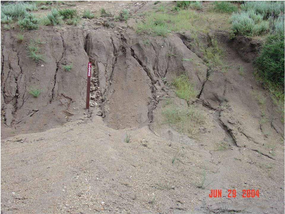
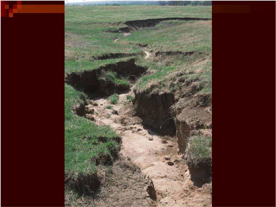
4 Types of Soil Erosion Rain drop or splash erosion: Erosion preceded by the destruction of the crumb structure due to the impact of falling raindrop on the surface of soil is termed as splash erosion. Sheet erosion: It is the fairly uniform removal of soil in thin layers from the land surface, often scarcely perceptible, especially when caused by wind. Areas where loose, shallow topsoil overlies compact soil are most susceptible to sheet erosion. Rill erosion: A form of water erosion in which numerous very small and more or less straight channels are produced; the channels get obliterated by ordinary use. It can be removed by normal tillage operations. Gully erosion: A form of water erosion in which gullies are produced by combination of unattended rills. Stream bank erosion: Stream banks are eroded by water either flowing over the sides of a stream or scouring at the base. It is aggravated by removal of vegetation, over grazing or cultivation near the stream banks.

5

6

7

8

9
10
11

12 Slope angle and length affects runoff generated when rain falls to the surface. Examine the diagram below showing the relationship between hill slope position, runoff, and erosion. Figure Hill slope position, runoff & erosion

13 Soil Types Ability to resist erosion forces

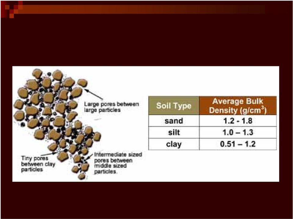
14 Soil Has Different Properties From: Geologic Origin Composition Chemical and Physical Erosion based on: Cohesive (clay) vs. Non cohesive (sand) Density and Particle Size Permeability and Change due to COMPACTION Strength Tensile, Shear, Bearing Capacity Water Table and Saturation Vegetation and Roots

15 Geologic Origin Parent Material character and chemical composition of the parent material plays an important role in determining soil properties Glaciers, Floods, and Water Movement As glaciers pushed, they act like giant bulldozers pushing soil ahead of them. Glacial till or drift deposits resulted many tens or even hundreds of miles from where the soils were first formed. Water is also very important in moving soils. As rivers flow, they transport soil particles along. If soil is washed into a river, the smallest particles will be carried the furthest by the water as they weigh the least. Heavier particles, such as sand, will be dropped earlier. Soils dropped around streams are termed alluvial. Soils deposited in lakes are called 'lacustrine', soils deposited by rivers 'riverine' and by sea 'marine' alluvial soils

16 Composition Percent Silt, Clay, Sand, Gravel Uniform or Poorly Graded Layered Horizontally or Diagonally Densely Packed or Loose Particle Sizes

17 Chemical and Physical Properties ph, Conductivity, Calcium Carbonate and plant survival Soil Structure Susceptibility of soil to sheet and rill erosion by water Plasticity Index Water Content

18

19

20
21
22 Vegetation Holds Soil Turf Grass 4.0 Ft 16 Ft
23
24 Erosion Depends on Soil Properties Highly Erodible Lands (Parent Material) Cohesive Clays or Non-cohesive sands Densely Packed or Loose Materials Permeability and Water Movement (seeps) How Soils perform under loading (structures) Effective stress and water table fluctuations
25
26
27
28
29
30 Various Techniques or Combinations of Techniques to Help Soils Prevent Erosion Natural Shoreline Native Plantings Biolog w/ Plantings Branch Box Breakwater Brush Mattress Live Fascine Branch Packing Vegetated Geogrid Rock Riprap Rock Riprap w/ Live Stakes; vegetated riprap Demo/Experimental
31 Biolog 3 YEAR OLD BIOLOG
32 Techniques Brush Mattress
33 Techniques Live Fascine
34 Branchbox Breakwater
35 Techniques Branch Packing
36 Techniques Vegetated Geogrid
37 Vegetated Riprap
38
39 Case Studies (1) Problem ID & Techniques used
40
41
42
43
44 Case Studies (1) Problem ID & Techniques Used, cont
45 Case Studies (1) Design Standards & Lessons Learned
46 Case Studies (2) Problem ID & Techniques Used
47 Case Studies (2) Design Standards & Lessons Learned
48 Case Studies (3) Problem ID & Techniques Used
49
50 Case Studies (3) Design Standards & Lessons Learned
51 Upland Runoff Erosion Factor
52
53
54
55
56
57 ShoreMax Product
58 Questions?
WEATHERING, EROSION, AND DEPOSITION PRACTICE TEST. Which graph best shows the relative stream velocities across the stream from A to B?
 NAME DATE WEATHERING, EROSION, AND DEPOSITION PRACTICE TEST 1. The diagram below shows a meandering stream. Measurements of stream velocity were taken along straight line AB. Which graph best shows the
Igneous rocks formed when hot molten material (magma) cools and hardens (crystallizes).
 cools and hardens (crystallizes).") Objectives You will learn about how the land of North Dakota was formed. Introduction North Dakota is a wonderful place to live. Have you ever though about how it was formed? To answer that question, you
Objectives You will learn about how the land of North Dakota was formed. Introduction North Dakota is a wonderful place to live. Have you ever though about how it was formed? To answer that question, you
5-Minute Refresher: WEATHERING AND EROSION
 5-Minute Refresher: WEATHERING AND EROSION Weathering and Erosion Key Ideas Weathering is the wearing away of the surface of rock, soil, and minerals into smaller pieces. Example of weathering: Wind and
Various options are discussed below.these low cost, low impact interventions can also be applied as general erosion control methods.
 Week 10 River Hydraulics Rehabilitating Urban Waterways (From http://hubpages.com/hub/river-bank-erosion-control-methods) See also the resources placed on Moodle. Water channels should be viewed as a resource
8/18/2014. Chapter 9: Erosion and Deposition. Section 1 (Changing Earth s Surface) 8 th Grade. Weathering
 8 th Grade. Weathering") Section 1 (Changing Earth s Surface) Weathering the chemical and physical processes that break down rock at Earth s surface Chapter 9: Erosion and Deposition 8 th Grade Mechanical weathering when rock
Section 1 (Changing Earth s Surface) Weathering the chemical and physical processes that break down rock at Earth s surface Chapter 9: Erosion and Deposition 8 th Grade Mechanical weathering when rock
Ecosystems One or more communities in an area and the abiotic factors, including water, sunlight, oxygen, temperature, and soil.
 7-4.1 Summarize the characteristics of the levels of organization within ecosystems (including populations, communities, habitats, niches, and biomes). Taxonomy level: 2.4-B Understand Conceptual Knowledge
Topic 8: Open Channel Flow
 3.1 Course Number: CE 365K Course Title: Hydraulic Engineering Design Course Instructor: R.J. Charbeneau Subject: Open Channel Hydraulics Topics Covered: 8. Open Channel Flow and Manning Equation 9. Energy,
Course Plan Day 1: Introduction and Overview Hydrology & Fluvial Geomorphology Day 2: Fieldwork on the Braid Burn Alan Jones
 Course Plan Day 1: Introduction and Overview Hydrology & Fluvial Geomorphology Alan Jones E:mail: Alan.Jones@ed.ac.uk Water cycle Globally & Locally River shapes and forms River behaviour Closer look at
Earth Science Landforms, Weathering, and Erosion Reading Comprehension. Landforms, Weathering, and Erosion
 Reading Comprehension Name 1 How many people have been to the Rocky Mountains or the Grand Canyon? When people go to visit these natural wonders, they may not realize that it took millions of years for
WEATHERING, EROSION, and DEPOSITION REVIEW
 WEATHERING, EROSION, and DEPOSITION REVIEW Weathering: The breaking up of rock from large particles to smaller particles. a) This Increases surface area of the rock which speeds the rate of chemical weathering.
Understanding Erosion. Revised Universal Soil Loss Equation
 Understanding Erosion with the Revised Universal Soil Loss Equation Towards a Better Understanding of the What, Why & How Erosion is a process of detachment and transport of soil particles by erosive forces.
Travel Time. Computation of travel time and time of concentration. Factors affecting time of concentration. Surface roughness
 3 Chapter 3 of Concentration and Travel Time Time of Concentration and Travel Time Travel time ( T t ) is the time it takes water to travel from one location to another in a watershed. T t is a component
Soils, Foundations & Moisture Control
 Soils, Foundations & Moisture Control Soil The top loose layer mineral and/or organic material on the surface of the Earth that serves as a natural medium for the growth of plants and support for the foundations
Recommended Resources: The following resources may be useful in teaching
 Unit D: Controlling Pests and Diseases in the Orchard Lesson 1: Managing and Controlling Pests of Fruit and Nut Crops Student Learning Objectives: Instruction in this lesson should result in students achieving
The concepts developed in this standard include the following: Oceans cover about 70% of the surface of the Earth.
 Name Date Grade 5 SOL 5.6 Review Oceans Made by SOLpass - www.solpass.org solpass100@comcast.net Reproduction is permitted for SOLpass subscribers only. The concepts developed in this standard include
RIPRAP From Massachusetts Erosion and Sediment Control Guidelines for Urban and Suburban Areas http://www.mass.gov/dep/water/laws/policies.
 RIPRAP From Massachusetts Erosion and Sediment Control Guidelines for Urban and Suburban Areas http://www.mass.gov/dep/water/laws/policies.htm#storm Definition: A permanent, erosion-resistant ground cover
Flash Flood Science. Chapter 2. What Is in This Chapter? Flash Flood Processes
 Chapter 2 Flash Flood Science A flash flood is generally defined as a rapid onset flood of short duration with a relatively high peak discharge (World Meteorological Organization). The American Meteorological
Mud in the Water. www.agclassroom.org/ok. Oklahoma Academic Standards. Objective. Background. Resources Needed. Activities
 Mud in the Water Objective Students will learn about soil erosion and water pollution by building a demonstration model from pop bottles and observing the movement of pollutants from soil into water. Background
CITY UTILITIES DESIGN STANDARDS MANUAL
 CITY UTILITIES DESIGN STANDARDS MANUAL Book 2 (SW) SW9 June 2015 SW9.01 Purpose This Chapter provides information for the design of open channels for the conveyance of stormwater in the City of Fort Wayne.
Neversink River East Branch
 Neversink River East Branch Management Unit 10 Summary of Post-Flood Recommendations Intervention Level Full restoration of the stream reach including the eroding bank site between Station 38380 and Station
FROM SEDIMENT INTO SEDIMENTARY ROCK. Objectives. Sediments and Sedimentation
 FROM SEDIMENT INTO SEDIMENTARY ROCK Objectives Identify three types of sediments. Explain where and how chemical and biogenic sediments form. Explain three processes that lead to the lithification of sediments.
WEPP MODEL APPLICATIONS FOR EVALUATIONS OF BEST MANAGEMENT PRACTICES
 WEPP MODEL APPLICATIONS FOR EVALUATIONS OF BEST MANAGEMENT PRACTICES D.C. FLANAGAN 1, W.J. ELLIOT 2, J.R. FRANKENBERGER 3, C. HUANG 4 1 USDA-Agricultural Research Service, National Soil Erosion Research
Carbonate Rock Formation
 Limestone, dolomite (or dolostone), and marble are often collectively referred to as carbonate rocks because the main mineral is calcite. The chemical name of calcite is calcium carbonate. Limestone, dolomite,
All sediments have a source or provenance, a place or number of places of origin where they were produced.
 Sedimentary Rocks, Processes, and Environments Sediments are loose grains and chemical residues of earth materials, which include things such as rock fragments, mineral grains, part of plants or animals,
Sedimentary Rocks. Find and take out 11B-15B and #1 From Egg Carton
 Sedimentary Rocks Find and take out 11B-15B and #1 From Egg Carton Erosion Erosion is a natural process where rocks and soil are Broken and Moved We will focus on 4 types of erosion; Wind, Rain, Ice and
Characteristics of Sedimentary Rocks
 Characteristics of Sedimentary Rocks Deposited at the earth s surface by wind, water, glacier ice, or biochemical processes Typically deposited in strata (layers) under cool surface conditions. This is
Weathering, Erosion, and Soils. Weathering and Erosion. Weathering and Erosion
 Weathering, Erosion, and Soils 1 The Grand Canyon, a landscape shaped by weathering and erosion 2 Weathering vs. erosion Types of weathering Physical Chemical Rates of weathering and erosion Climate Rock
Communities, Biomes, and Ecosystems
 Communities, Biomes, and Ecosystems Before You Read Before you read the chapter, respond to these statements. 1. Write an A if you agree with the statement. 2. Write a D if you disagree with the statement.
Index. protection. excavated drop inlet protection (Temporary) 6.50.1 6.51.1. Block and gravel inlet Protection (Temporary) 6.52.1
 6.50.1 6.51.1. Block and gravel inlet Protection (Temporary) 6.52.1") 6 Index inlet protection excavated drop inlet protection (Temporary) 6.50.1 HARDWARE CLOTH AND GRAVEL INLET PROTECTION Block and gravel inlet Protection (Temporary) sod drop inlet protection ROCK DOUGHNUT
6 Index inlet protection excavated drop inlet protection (Temporary) 6.50.1 HARDWARE CLOTH AND GRAVEL INLET PROTECTION Block and gravel inlet Protection (Temporary) sod drop inlet protection ROCK DOUGHNUT
PILE FOUNDATIONS FM 5-134
 C H A P T E R 6 PILE FOUNDATIONS Section I. GROUP BEHAVIOR 6-1. Group action. Piles are most effective when combined in groups or clusters. Combining piles in a group complicates analysis since the characteristics
Emergency Spillways (Sediment basins)
") Emergency Spillways (Sediment basins) DRAINAGE CONTROL TECHNIQUE Low Gradient Velocity Control Short-Term Steep Gradient Channel Lining Medium-Long Term Outlet Control Soil Treatment Permanent [1] [1]
Emergency Spillways (Sediment basins) DRAINAGE CONTROL TECHNIQUE Low Gradient Velocity Control Short-Term Steep Gradient Channel Lining Medium-Long Term Outlet Control Soil Treatment Permanent [1] [1]
2 Wind Erosion and Deposition
 CHAPTER 3 2 Wind Erosion and Deposition SECTION Agents of Erosion and Deposition BEFORE YOU READ After you read this section, you should be able to answer these questions: How can wind erosion shape the
Outlet stabilization structure
 Overview of Sedimentation and Erosion Control Practices Practice no. 6.41 Outlet stabilization structure Erosion at the outlet of channels, culverts, and other structures is common, and can cause structural
Earth Science. River Systems and Landforms GEOGRAPHY 1710. The Hydrologic Cycle. Introduction. Running Water. Chapter 14.
 Earth Science GEOGRAPHY 1710 River Systems and Landforms DAVID R. SALLEE Robert W. Christopherson Charlie Thomsen Chapter 14 Introduction Rivers and streams are dynamic systems that continually adjust
Welded Mesh Gabions and Mattresses River Protection Design Guide HY-TEN GABION SOLUTIONS Dunstall Hill Trading Estate, Gorsebrook Road,
 Welded Mesh Gabions and Mattresses River Protection Design Guide HY-TEN GABION SOLUTIONS Dunstall Hill Trading Estate, Gorsebrook Road, Wolverhampton, WV6 0PJ Tel 01902 712200 Fax 01902 714096 e-mail sales@hy-tengabions.com
6. Base your answer to the following question on the graph below, which shows the average monthly temperature of two cities A and B.
 1. Which single factor generally has the greatest effect on the climate of an area on the Earth's surface? 1) the distance from the Equator 2) the extent of vegetative cover 3) the degrees of longitude
GLOSSARY OF TERMS CHAPTER 11 WORD DEFINITION SOURCE. Leopold
 CHAPTER 11 GLOSSARY OF TERMS Active Channel The channel that contains the discharge Leopold where channel maintenance is most effective, sediment are actively transported and deposited, and that are capable
Science of Life Explorations
 Science of Life Explorations Student Scientists: What do Plants Need for Growth? Introduction Do you ever wonder why grass grows, flowers bloom, and fruits blossom and ripen? It is because they are getting
Water & Climate Review
 Water & Climate Review 1. The cross section below shows the direction of air flowing over a mountain. Points A and B are at the same elevation on opposite sides of the mountain. 4. The graph below shows
How to Build a Rain Garden at Your Home
 How to Build a Rain Garden at Your Home Virginia gets an average of 45.22 inches of rain a year. Rain that runs off your roof or patio can flow into a sewer pipe, stream or groundwater. Why not put it
ENVIRONMENTAL CODE OF PRACTICE FOR CONCRETE BATCH PLANT & ROCK WASHING OPERATIONS
 ENVIRONMENTAL CODE OF PRACTICE FOR CONCRETE BATCH PLANT & ROCK WASHING OPERATIONS PREPARED BY: DEPARTMENT OF ENVIRONMENT AND LANDS INDUSTRIAL ENVIRONMENTAL ENGINEERING DIVISION APRIL 16, 1992 - TABLE OF
PART TWO GEOSYNTHETIC SOIL REINFORCEMENT. Martin Street Improvements, Fredonia, Wisconsin; Keystone Compac Hewnstone
 GEOSYNTHETIC SOIL REINFORCEMENT Martin Street Improvements, Fredonia, Wisconsin; Keystone Compac Hewnstone DESIGN MANUAL & KEYWALL OPERATING GUIDE GEOSYNTHETIC SOIL REINFORCEMENT Keystone retaining walls
The students will be working in and alongside the stream, so safety is a consideration. Suitable sites should have the following characteristics:
 Measuring Stream Banks: Height and Slope Stream bank heights and slopes are of interest because they yield information relevant to bank erosion and stability. A high, steep bank is likely to be unstable
Basic Hydrology. Time of Concentration Methodology
 Basic Hydrology Time of Concentration Methodology By: Paul Schiariti, P.E., CPESC Mercer County Soil Conservation District What is the Time of Concentration? The time it takes for runoff to travel from
Settlement of Foundations on Expansive Clays Due to Moisture Demand of Trees CIGMAT 2008
 Settlement of Foundations on Expansive Clays Due to Moisture Demand of Trees CIGMAT 2008 Kenneth E. Tand, P.E. Practicing Geotechnical Engineer FRIEND OR FOE Trees are our friends. They extract carbon
Introduction to Rainwater Harvesting. Department of Biological and Agricultural Engineering Texas A&M University
 Introduction to Rainwater Harvesting Department of Biological and Agricultural Engineering Texas A&M University Rainfall in your watershed What is a watershed? An area of land that drains to a common point
Climate, Vegetation, and Landforms
 Climate, Vegetation, and Landforms Definitions Climate is the average weather of a place over many years Geographers discuss five broad types of climates Moderate, dry, tropical, continental, polar Vegetation:
Permeable Pavement Construction Guide
 Permeable Pavement Construction Guide Permeable pavement at Olympic Park, Waitakere Final Construction result What are permeable pavements? Permeable pavements are hard surface paving systems that reduce
GEOTECHNICAL ENGINEERING FORMULAS. A handy reference for use in geotechnical analysis and design
 GEOTECHNICAL ENGINEERING FORMULAS A handy reference for use in geotechnical analysis and design TABLE OF CONTENTS Page 1. SOIL CLASSIFICATION...3 1.1 USCS: Unified Soil Classification System...3 1.1.1
Rocks & Minerals. 10. Which rock type is most likely to be monomineralic? 1) rock salt 3) basalt 2) rhyolite 4) conglomerate
 rock salt 3) basalt 2) rhyolite 4) conglomerate") 1. Of the Earth's more than 2,000 identified minerals, only a small number are commonly found in rocks. This fact indicates that most 1) minerals weather before they can be identified 2) minerals have
1. Of the Earth's more than 2,000 identified minerals, only a small number are commonly found in rocks. This fact indicates that most 1) minerals weather before they can be identified 2) minerals have
SUSTAINABLE URBAN DRAINAGE SYSTEMS
 overflow can lead into a permeable conveyance system to increase further the benefit and reduce the need for pipe systems. Pollutant removal rates have been shown to be high, with some pollutants being
DOÑA ANA COUNTY DESIGN STORM CRITERIA GUIDELINES FOR COMMERCIAL AND RESIDENTIAL SITES. Run-off Analysis Methods
 DOÑA ANA COUNTY DESIGN STORM CRITERIA GUIDELINES FOR COMMERCIAL AND RESIDENTIAL SITES Run-off Analysis Methods This document sets forth the minimum design, technical criteria and specifications for the
Rain Gardens: Designing your Landscape to Protect Aquatic Resources. Curtis Hinman WSU Extension Faculty Watershed Ecologist chinman@wsu.
 Rain Gardens: Designing your Landscape to Protect Aquatic Resources Curtis Hinman WSU Extension Faculty Watershed Ecologist chinman@wsu.edu Basic Design Characteristics Shallow landscaped depressions that
Sediment and Sedimentary Rocks
 Page 1 of 10 EENS 1110 Tulane University Physical Geology Prof. Stephen A. Nelson Sediment and Sedimentary Rocks This page last updated on 15-Sep-2015 Sedimentary Rocks Rivers, oceans, winds, and rain
1. A student found a sample of a solid material that was gray, shiny and made of all the same material. What category does this sample best fit?
 Grade 4 Standard 3 Unit Test A Earth Materials Multiple Choice 1. A student found a sample of a solid material that was gray, shiny and made of all the same material. What category does this sample best
Siting and settlement: The most important way to protect shelter from floods is to build in a place that is unlikely to be flooded.
 Siting and settlement: The most important way to protect shelter from floods is to build in a place that is unlikely to be flooded. Key Messages Shelters and settlements should be sited above the highest
Post-Wildfire Clean-Up and Response in Houston Toad Habitat Best Management Practices
 Post-Wildfire Clean-Up and Response in Houston Toad Habitat Best Management Practices Purpose The purpose of this document is to provide guidance and recommendations for minimizing potential impacts to
Geomorphology is the Study of Landforms. Usually by Erosion, Transportation and Deposition
 Geomorphology is the Study of Landforms and the Processes that t Create Them, Usually by Erosion, Transportation and Deposition Fluvial = running water, rivers and floodplains Glacial = flowing ice in
When Water Comes to Town What Happens
 W When Water Comes to Town What Happens hen it rains, stormwater either seeps into the ground or flows away depending on the kind of surface upon which it lands. Water infiltrates pervious ground surfaces
INDIRECT METHODS SOUNDING OR PENETRATION TESTS. Dr. K. M. Kouzer, Associate Professor in Civil Engineering, GEC Kozhikode
 INDIRECT METHODS SOUNDING OR PENETRATION TESTS STANDARD PENETRATION TEST (SPT) Reference can be made to IS 2131 1981 for details on SPT. It is a field edtest to estimate e the penetration e resistance
How To Check For Scour At A Bridge
 Case Studies Bridge Scour Inspection and Repair Edward P. Foltyn, P.E. Senior Hydraulic Engineer ODOT Bridge Unit 2013 PNW Bridge Inspectors Conference April 2013 REFERENCES Stream Stability at Highway
Part 7 GEOTEXTILE FILTER FABRICS
 Part 7 GEOTEXTILE FILTER FABRICS Well Screens Slotted casings are normally employed as well screens within the aquifers being taped by water wells. The width of the slots should allow 50 to 60% of the
Erosion Control Blanket (ECB)
") Erosion Control Blanket (ECB) Practice Description To aid in controlling erosion on critical areas by providing a protective cover made of straw, jute, wood or other plant fibers; plastic, nylon, paper
Erosion Control Blanket (ECB) Practice Description To aid in controlling erosion on critical areas by providing a protective cover made of straw, jute, wood or other plant fibers; plastic, nylon, paper
Water Clean- up Crew. Learn about water quality and how to solve different water quality problems. Time Needed 1 hour
 Water Clean- up Crew Learn about water quality and how to solve different water quality problems Time Needed 1 hour Ages 4 th to 6 th Season Any Materials aluminum trays, tape, tin foil, sponges, clay,
GUIDELINES FOR SOIL FILTER MEDIA IN BIORETENTION SYSTEMS (Version 2.01) March 2008
 March 2008") GUIDELINES FOR SOIL FILTER MEDIA IN BIORETENTION SYSTEMS (Version 2.01) March 2008 The following guidelines for soil filter media in bioretention systems have been prepared on behalf of the Facility for
GUIDELINES FOR SOIL FILTER MEDIA IN BIORETENTION SYSTEMS (Version 2.01) March 2008 The following guidelines for soil filter media in bioretention systems have been prepared on behalf of the Facility for
CHAPTER 5 OPEN CHANNEL HYDROLOGY
 5.4 Uniform Flow Calculations 5.4.1 Design Charts CHAPTER 5 OPEN CHANNEL HYDROLOGY Following is a discussion of the equations that can be used for the design and analysis of open channel flow. The Federal
Sand and Silt Removal from Salmonid Streams
 Sand and Silt Removal from Salmonid Streams Stream bank erosion Poor land use practices Sources of Sand and Silt Impacts of Sand and Silt Interstitial spaces infilled Little or no flow through the streambed
ENCE 4610 Foundation Analysis and Design
 This image cannot currently be displayed. ENCE 4610 Foundation Analysis and Design Shallow Foundations Total and Differential Settlement Schmertmann s Method This image cannot currently be displayed. Strength
Stabilenka HUESKER. and Separation. Engineering with Geosynthetics SKER HUESKER HUESKER HUESKER HUESKERHUES
 HUESKER Engineering with Geosynthetics rhuesker HUESKER HUESKER HUESKER HUESKER HUESKERr rhuesker HUESKER Woven HUESKER HUESKER Fabrics HUESKER HUESKERr SKER HUESKER HUESKER HUESKER HUESKERHUES rhuesker
Gettysburg Adams Chamber of Commerce Storm Water Management
 Gettysburg Adams Chamber of Commerce Storm Water Management Table of Contents Section 1 Section 2 Section 3 Section 4 Section 5 Section 6 Section 7 Introduction Understanding Location and Landscape 2.1
Ride the Rock Cycle. Suggested Goals: Students will gain an understanding of how a rock can move through the different stages of the rock cycle.
 Illinois State Museum Geology Online http://geologyonline.museum.state.il.us Ride the Rock Cycle Grade Level: 5 6 Purpose: To teach students that the rock cycle, like the water cycle, has various stages
Sedimentary Rocks, Depositional Environments and Stratigraphy
 Sedimentary Rocks, Depositional Environments and Stratigraphy The Nature of Sedimentary Rocks Sedimentary rocks are composed of: Fragments of other rocks (detrital or clastic) Chemical precipitates Organic
NJ650.1404 Interception Drainage
 NJ650.1404 Interception Drainage Interception drainage is used to intercept surface and subsurface water. The investigation, planning, and construction of surface interception drains follow the requirements
Porous Pavement Alternatives Cost Analysis
 Porous Pavement Alternatives Cost Analysis Prepared by Century West Engineering for Metro This cost analysis compares the construction costs of six different types of pavement for three different scenarios.
BRIDGE SCOUR INVESTIGATION: DEVELOPING A SCREENING AND HYDRAULIC VULNERABILITY RATING SYSTEM FOR BRIDGES B.HERON 1 & C.BOWE 2
 BRIDGE SCOUR INVESTIGATION: DEVELOPING A SCREENING AND HYDRAULIC VULNERABILITY RATING SYSTEM FOR BRIDGES B.HERON 1 & C.BOWE 2 1 O Connor Sutton Cronin Consulting Engineers, Dublin, Ireland 2 Iarnród Éireann,
What are the controls for calcium carbonate distribution in marine sediments?
 Lecture 14 Marine Sediments (1) The CCD is: (a) the depth at which no carbonate secreting organisms can live (b) the depth at which seawater is supersaturated with respect to calcite (c) the depth at which
What is Soil Survey?
 What is Soil Survey? Soil Survey is a systematic examination, description, classification, and mapping of the soils in a given area. Brady and Weil. 1996 Who Produces Soil Survey Cooperative effort between
BMP 6.7.3: Soil Amendment & Restoration
 BMP 6.7.3: Soil Amendment & Restoration Soil amendment and restoration is the process of improving disturbed soils and low organic soils by restoring soil porosity and/or adding a soil amendment, such
Sedimentary Rock Formation Models. 5.7 A Explore the processes that led to the formation of sedimentary rock and fossil fuels.
 Sedimentary Rock Formation Models 5.7 A Explore the processes that led to the formation of sedimentary rock and fossil fuels. The Formation Process Explained Formation of these rocks is one of the important
Module 7 (Lecture 24 to 28) RETAINING WALLS
 RETAINING WALLS") Module 7 (Lecture 24 to 28) RETAINING WALLS Topics 24.1 INTRODUCTION 24.2 GRAVITY AND CANTILEVER WALLS 24.3 PROPORTIONING RETAINING WALLS 24.4 APPLICATION OF LATERAL EARTH PRESSURE THEORIES TO DESIGN 24.5
Module 7 (Lecture 24 to 28) RETAINING WALLS Topics 24.1 INTRODUCTION 24.2 GRAVITY AND CANTILEVER WALLS 24.3 PROPORTIONING RETAINING WALLS 24.4 APPLICATION OF LATERAL EARTH PRESSURE THEORIES TO DESIGN 24.5
The Characteristics of Clay. Table of Contents
 The Characteristics of Clay Table of Contents Preview...2 Objectives...2 Readings...2 Introduction...3 Structure of clay minerals...3 Physical features...3 Mineralogical features...4 A. Basic structure
Vegetative Filter Strips
 9.10 VEGETATIVE FILTER STRIPS A vegetative filter strip is a stable, evenly graded area that removes pollutants from stormwater runoff through filtration and biological uptake. In order to provide pollutant
WHAT YOU NEED TO KNOW ABOUT LIVING NEAR INDIANA COAL MINES
 WHAT YOU NEED TO KNOW ABOUT LIVING NEAR INDIANA COAL MINES Who Should Read This Guide? Home Buyers/Owners Lending Institutions Landowners Developers Local Officials Construction Design Realtors Companies
How fast water travels through soils?
 How fast water travels through soils? Subject Area(s) Earth and Space Associated Unit Associated Lesson Header Image 1 ADA Description: Perspective sight illustrating a dam used to retain water for supplying
Final Report. Dixie Creek Restoration Project. Funded by Plumas Watershed Forum
 Final Report Dixie Creek Restoration Project Funded by Plumas Watershed Forum Plumas Corporation January 2009 1 Background FR-CRM staff presented this project to the Dixie Valley Landowners Association
LOW INTEREST LOANS FOR AGRICULTURAL CONSERVATION
 LOW INTEREST LOANS FOR AGRICULTURAL CONSERVATION LILAC MANUAL LOW INTEREST LOANS FOR AGRICULTURAL CONSERVATION TABLE OF CONTENTS Introduction... 3 General Eligibility... 4 Specific Eligibility Criteria
1. Michigan Geological History Presentation (Michigan Natural Resources)
") 1. Michigan Geological History Presentation (Michigan Natural Resources) The Michigan Geological History Presentation provides an overview of the approximately 3 billion years of Earth Processes that the
1. Michigan Geological History Presentation (Michigan Natural Resources) The Michigan Geological History Presentation provides an overview of the approximately 3 billion years of Earth Processes that the
Sediment Supply and the Upland-Stream Connection. Brian Bledsoe Department of Civil and Environmental Engineering Colorado State University
 Sediment Supply and the Upland-Stream Connection Brian Bledsoe Department of Civil and Environmental Engineering Colorado State University Overview The sediment system (with an eye towards hillslope processes
Homeowner s Guide to Maintaining a Sewage Treatment System
 Homeowner s Guide to Maintaining a Sewage Treatment System Warren County Combined Health District 416 South East Street Lebanon, OH 45036 513-695-1220 Sewage Treatment Systems Septic Tank and Soil Absorption
Riprap-lined Swale (RS)
") Riprap-lined Swale (RS) Practice Description A riprap-lined swale is a natural or constructed channel with an erosion-resistant rock lining designed to carry concentrated runoff to a stable outlet. This
Riprap-lined Swale (RS) Practice Description A riprap-lined swale is a natural or constructed channel with an erosion-resistant rock lining designed to carry concentrated runoff to a stable outlet. This
720 Contour Grading. General. References. Resources. Definitions
 720 Contour Grading General Contour grading directs water to a desired point, prevents erosion, provides noise deflection, provides visual fit of the facility into the landscape, and protects desirable
An Online School for Weather. www.srh.noaa.gov/jetstream/atmos/ll_whatacycle_aquifers.pdf
 JetStream An Online School for Weather Aquifers Aquifers Aquifers 1 3 5 Aquifers Aquifers Aquifers 2 4 6 /atmos/ll_whatacycle_aquifers.pdf There are over 35 lesson plans in the National Weather Service
The Hydrologic Cycle. precipitation evaporation condensation transpiration infiltration surface runoff transport groundwater water table.
 The Hydrologic Cycle Page 1 of 1 Name Directions: The hydrologic cycle consists of the processes that change and move water through the earth s system. Use the terms below to label the hydrologic cycle.
STORM WATER MANAGEMENT HANDBOOK FOR CONSTRUCTION ACTIVITIES
 STORM WATER MANAGEMENT HANDBOOK FOR CONSTRUCTION ACTIVITIES Prepared by City of Houston Harris County Harris County Flood Control District 2006 Edition NOTICE TO USERS The Storm Water Management Handbook
Failing Culverts Structural Problems & Economic Considerations
 Failing Culverts Structural Problems & Economic Considerations Al Tenbusch, President, Tenbusch, Inc. Brian Dorwart, Senior Associate, Brierley Associates Albert F. Tenbusch, Engineer, Tenbusch, Inc. June
APPLICATION PROCESS FOR LAND DISTURBING PERMIT
 PREFACE: APPLICATION PROCESS FOR LAND DISTURBING PERMIT The property owner, developer and designated planners and engineers shall review the general development plans and detailed plans of the Local Issuing
Chicago s Garden Roofs and Drainage / Water Retention
 Chicago s Garden Roofs and Drainage / Water Retention Chicago s Garden Roofs Learning Objectives To understand how Garden Roofs slow water drainage, and why it s important Why Do Garden Roofs Make Sense
The rock cycle. Introduction. What are rocks?
 The rock cycle This Revision looks at the three types of rock: sedimentary, igneous and metamorphic. It looks at how they are formed, the weathering of rocks and the way one form of rock turns into another,
Scheduling Maintenance for Infiltration Basins and Trenches
 Visual Inspection for Infiltration Practices Visual inspection is a rapid assessment procedure for qualitatively evaluating the functionality of a stormwater best management practice (BMP). Visual inspections
Hydrogeology Experiment on Surface-Groundwater Interactions: How Do Our Actions Affect Water Quantity and Quality?
 Name: Period: Hydrogeology Experiment on Surface-Groundwater Interactions: How Do Our Actions Affect Water Quantity and Quality? Purpose/Objective: Students will learn how groundcover influences surface