GROUND WATER INFORMATION BOOKLET CHITRADURGA DISTRICT, KARNATAKA
|
|
|
- Helena Riley
- 9 years ago
- Views:
Transcription
1 GOVERNMENT OF INDIA MINISTRY OF WATER RESOURCES CENTRAL GROUND WATER BOARD GROUND WATER INFORMATION BOOKLET CHITRADURGA DISTRICT, KARNATAKA MOLAKALMURU CHITRADURGA CHALLAKERE HOLALKERE HIRIYUR HOSDURGA SOUTH WESTERN REGION BANGALORE AUGUST 2007

2 FOREWORD Ground water contributes to about eighty percent of the drinking water requirements in the rural areas, fifty percent of the urban water requirements and more than fifty percent of the irrigation requirements of the nation. Central Ground Water Board has decided to bring out district level ground water information booklets highlighting the ground water scenario, its resource potential, quality aspects, recharge discharge relationship, etc., for all the districts of the country. As part of this, Central Ground Water Board, South Western Region, Bangalore, is preparing such booklets for all the 27 districts of Karnataka state, of which six of the districts fall under farmers distress category. The Chitradurga district Ground Water Information Booklet has been prepared based on the information available and data collected from various state and central government organisations by several hydro-scientists of Central Ground Water Board with utmost care and dedication. This booklet has been prepared by Dr. Anant Kumar Ars, Assistant Hydrogeologist, under the guidance of Dr. K.Md. Najeeb, Superintending Hydrogeologist, Central Ground Water Board, South Western Region, Bangalore. I take this opportunity to congratulate them for the diligent and careful compilation and observation in the form of this booklet, which will certainly serve as a guiding document for further work and help the planners, administrators, hydrogeologists and engineers to plan the water resources management in a better way in the district. Sd/- (T.M.HUNSE) Regional Director

3 Sl. No CHITRADURGA DISTRICT AT A GLANCE Items Statistics General Information (i) Geographical area (sq. km.) 8388 (ii) Administrative Division (as in ) (a) Number of Taluks (b) Number of Panchayats/ Villages 6 (Challakere, Chitradurga, Hiriyur, Holalkere, Hosadurga & Molkalmuru) 185 Gram Panchayats & 1059 villages (iii) Population (as per 2001 Census) 15,10,227 Geomorphology (i) Major physiographic units (ii) Major Drainage Undulating plains, interspersed with sporadic ranges, isolated low ranges of rocky hills. Krishna main basin. Vedavathi, Janagahalli, Swarnamukhi & yakanahalli Nalla sub basin. 3. Land Use (sq. km.) (i) Forest area (ha) 73,719 (ii) Net area sown (ha) 4,69, Major soil types Deep & shallow black soil, Mixed red & black soil, Red 5. Loamy & sandy soil. Irrigation by different sources (Areas & Numbers of structures) (as per Third Census of Minor Irrigation Schemes ) (i) Dug wells ha & 2314 No. of dug wells (ii) a. Shallow tube wells (a) ha & No. of shallow tube wells. b. Deep tube wells (b) 425 ha & 1 No. of deep tube well.
 (i) Forest area (ha) 73,719 (ii) Net area sown (ha) 4,69,837 4.")
4 (iii) Other sources: (a) Lift Irrigation Schemes (a) ha & 106 No. of Lift irrigation schemes. 6. (b) Surface Flow Irrigation (b) ha & 157 No. of Surface flow irrigation schemes. Number of ground water monitoring wells of Central Ground Water Board (as on ) (i) Dug wells 47 (ii) Piezometers Predominant Geological Formations Charnokite, gneisses & unclassified crystallines, slates, phyllites, schists & granite. 8. Hydrogeology (i) Major water bearing formation Gneiss & Granites (weathered & fractured) (ii) Pre-monsoon depth to water level during May 2006 (in mbgl) 0.15 to (iii) Post monsoon depth to water level during 2006 (in mbgl) 2.75 to (iv) Long term water level trend in 10 years ( ) (a) Pre monsoon; May 1997 May 2006 (m/year) (a) In 5 NHS water levels show rising trend within the range to & in 5 NHS water levels show falling trend within the range 0.02 to (b) Post monsoon; Nov Nov (m/year) Ground water exploration by Central Ground Water Board (as on ) (i) Number of wells drilled (EW, OW, PZ, SH, Total) (b) In 5 NHS water levels show rising trend within the range 0.08 to & in 6 NHS water levels show falling trend within the range to EW; 12 PZ (ii) Depth Range (mbgl) 32.6 to 200 (iii) Discharge (litres per second) 0.04 to (iv) Transmissivity (m 2 /day) 2.37 to 75.88
 Major water bearing formation Gneiss & Granites (weathered & fractured) (ii) Pre-monsoon depth to water level during May 2006 (in mbgl) 0.15 to 15.")
5 Ground water quality (i) Presence of chemical constituents more than permissible Fluoride & Nitrate limit Dynamic ground water resource (2004) (in mcm) (i) Annual replenishable ground water resource (ham) (ii) Net Annual Ground Water Draft (ham) (iii) Projected demand for domestic & industrial uses upto (ham) (iv) Stage of ground water development (%) 103 Awareness & Training activity (i) Mass awareness programmes organized (a) Date (b) Place Dallara Bhavan, Challakere taluk. (ii) Water management Training Programmes organized (a) Date 19 th & 20 th January 2005 (b) Place Zilla Panchayat office, Chitradurga Artificial recharge & rainwater harvesting (i) Projects completed by CGWB (No. & amount spent) Nil (ii) Projects under technical guidance of CGWB Nil Ground water control & Regulation (i) Number of OE blocks 2 (Chitradurga & Holalkere) (ii) Number of Critical blocks 2 (Challakere & Hiriyur) (iii) Number of blocks notified Nil
 (iv) Stage of ground water development (%) 103 Awareness & Training activity (i) Mass awareness programmes organized (a) Date 30.03.05 (b) Place Dallara Bhavan, Challakere taluk.")
6 CHITRADURGA DISTRICT 1.0 Introduction In general the rainfall in the district during the last decade ( ) was higher than long-term normal rainfall. However, the district faced deficit rainfall continuously from 2002 to It was reported that a total of 101 farmers have committed suicide in the district between of which 45 suicides are reported to be due to crop failure. The highest number of suicides due to crop failure is reported during & respectively, which incidentally happens to be the lowest rainfall year in the last decade (Table 1). The taluk-wise details of the suicide of farmers in the district as reported by the agriculture commissioner is mentioned in Table 1. Chitradurga district covers a geographical area of 8388 sq.kms and comprises six taluks (Figure 1). It receives low to moderate rainfall and is one of the drought prone districts in the state. Normal annual rainfall varies between 668mm in Holalkere in western part to 457mm in Chellakere, in the northeastern part. Major part of the district lies in Krishna basin and is drained by Vedavathi River. The reservoir is built across the Vedavathi River near Vanivilaspura, in Hiriyur taluk. The canal network provides irrigation facilities to the farmers in Hiriyur taluk and for a few villages situated outside the taluk limit as well. The other streams are Janagahalli, Chikhagari, Swarnamukhi, Garain and Nayakanahalli halla(figure 2). Agriculture is mainly dependent on the timely and adequate rainfall in the district. However, the district is drained mainly by the Vedavathi River. Across Vedavathi river and its tributaries, the following irrigation projects are commissioned; (1) Vanivilas Sagara, (2) Gayathri Reservoir, (3) Rangayanadurga Reservoir and (4) Narayanapura Anicut. In addition to the above, there are about 300 tanks in the district providing irrigation facilities to small stretches of lands. The area is generally gently sloping from southwest to east. The drainage density varies from 0.72 to 1.70 km/km 2 and general ground elevation ranges from about 500 m amsl to 800 m amsl. Central Ground Water Board has carried out Systematic Hydrogeological Surveys during Ground water resource evaluation was carried out under Vedavathi River Basin Project during Reappraisal hydrogeological surveys were carried out during and exploratory drilling during & and continued during in the district. Thirty numbers of bore wells were drilled, by CGWB, through out sourcing, for water supply in the hardcore villages of Chellakere, Holalkere & Chitradurga. All these works in the district have brought out an upto-date status of ground water development scenario and ground water potential of the district.
.")
7 Table 1: Data on suicide of farmers Total Sl. no Taluks Total cases reported Due to Crop loss Due to other reasons Total cases reported Due to Crop loss Due to other reasons Total cases reported Due to Crop loss Due to other reasons Total cases reported Due to Crop loss Due to other reasons Total cases reported Due to Crop loss Due to other reason 1 Challakere Chitradurga Hiriyur Holalkere Hosadurga Molakalmuru Total

8

9

10 2.0 Rainfall The normal annual rainfall in the district based on 30years is 574mm. However, in the last decade ( ) the district received an average annual rainfall of 631.7mm. Further analysis of rainfall data (Table 2) indicate that the there was deficient rainfall in the years 2003, whereas the year 2005 received excess rainfall. The taluks of Chellakere & Chitradurga faced deficit rainfall in the years of 2002 & 2004 as well, most of the other taluks had deficit rainfall during two successive years 2002 and Post-monsoon rainfall had failed in the district during 2001 and During the year 2003 the pre- and post-monsoon season, rainfall had failed. Rainfall is lowest in Challakere taluk and highest in Hosadurga taluk. Table 2.Taluk wise annual rainfall (in mm) Year Challakere Chitradurga Hiriyur Holalkere Hosadurga Molkalmur Average Geomorphology & soil type Soil types of the district comprise deep & shallow black soil, mixed red & black soil, red loamy & sandy soil. Physiographically the district comprises of undulating plains, interspersed with sporadic ranges and isolated low ranges of rocky hills. 4.0Ground water Scenario 4.1 Hydrogeology Groundwater occurs under phreatic condition in the weathered rock formations of the Peninsular Gneissic Group of rocks comprising of Granites, gneisses and schist (Figure 3). The thickness of weathered zone varies from less than a meter near hill slopes and higher altitudes to about 39 m. in valleys and topographic low areas.

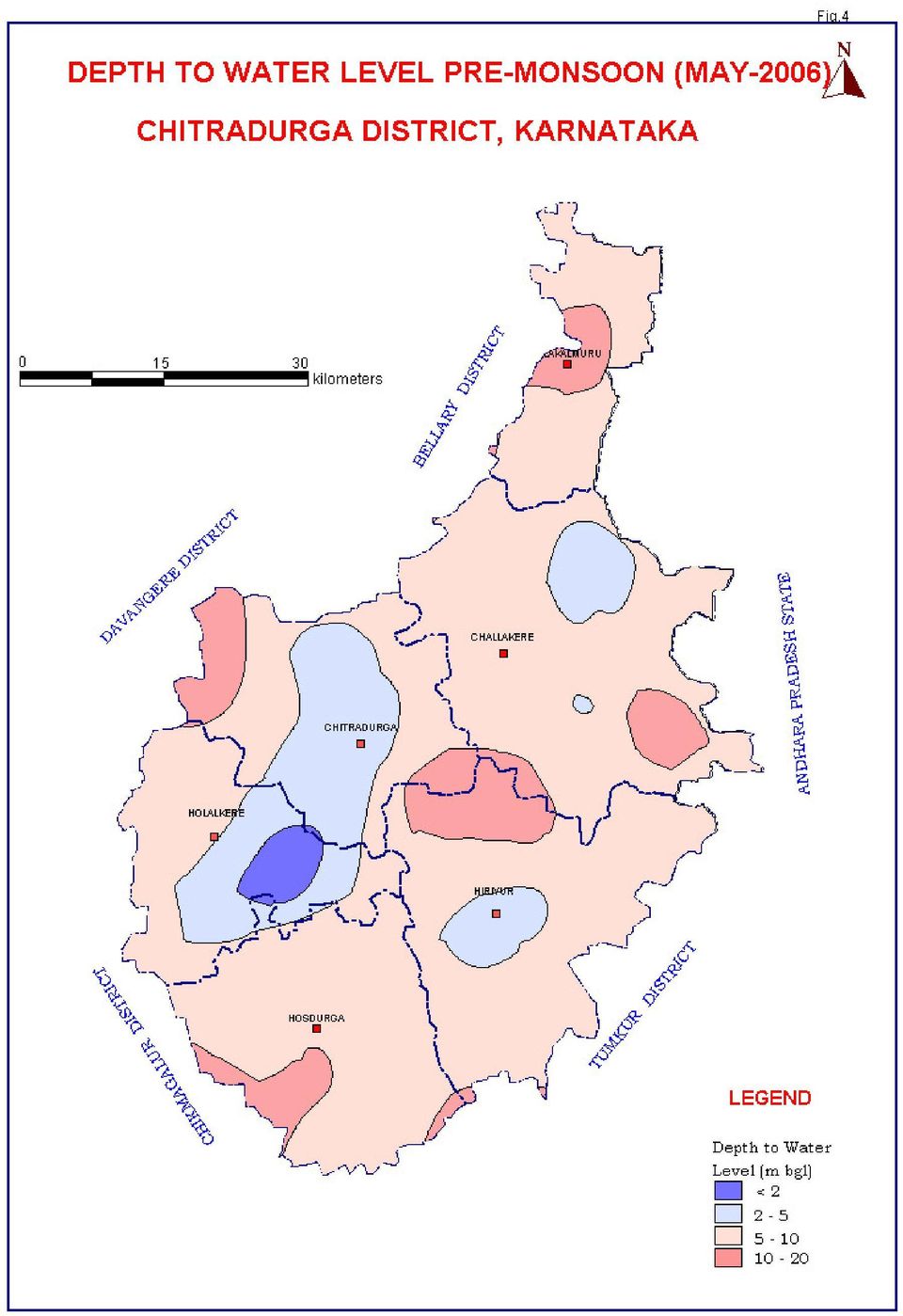
11

12 At depth, the groundwater occurs in the fractures and fault zone of these crystalline rocks under semi-confined to confined conditions. The main source of ground water occurring in the district is through precipitation and return flow from applied irrigation. In Molakalmur taluk, granites, granitic-gneisses and amphibolitegneisses are the main water bearing formations. Ground water exploration reveals the existence of 3 to 5 potential fracture zones having a thickness of 1 to 10 m. between the depths of 30 to 200 mbgl. In Molakalmur taluk exploratory bore wells were drilled from a minimum depth of mbgl to a maximum of 200 mbgl. Depth of weathered zone ranges from 12.3m to 24 mbgl.yeild ranges from<1.0 to 7.1lps.Transmisivity ranges from 9.84 m 2 /day to m 2 /day. Specific Capacity ranges from 9.84 lpm/m to lpm/m During May 2006 (pre-monsoon) the minimum depth to water level and maximum depth to water level are 9.77and 12.68mbgl respectively (Figure 4). During November 2006 (post-monsoon) water levels range from to to16.05 mbgl (Figure 5). Seasonal fluctuation of ground water level varies from 2.91m to5.77m. In Chitradurga taluk fractured granitic-gneisses, gneisses and hornblende-schists are the main water bearing formations. Ground water exploration reveals that aquifers are encountered between the depths of 15 mbgl and 192 mbgl. In Chitradurga taluk bore wells were drilled from a minimum depth of mbgl to a maximum of 200 mbgl. Depth of weathered zone range from 5.52m to 2.61mbgl.Yeild ranges from 0.04 to 5.42 lps. Transmissivity ranges from 2.37 to 40.84m 2 /day. Specific capacity ranges from 4.53 to lpm/m draw down. Ground water occurs within the weathered and fractured rocks under water-table conditions and semi-confined conditions. During May 2006 (pre-monsoon season) the minimum and maximum depth to water level are 2.43 and mbgl respectively (Figure 4). During November 2006 (post-monsoon) water level ranges from 2.75 to mbgl (Figure 5). Seasonal water-level fluctuation varies from 1.38 m to 1.86 m In Holalkere taluk, gneisses, schists and greywackes are the main water bearing formations. Ground water occurs within the weathered and fractured rocks. Ground water occurs under water-table condition and semi-confined condition. Ground water exploration reveals that aquifers were encountered between 25 mbgl to 169 mbgl. In Holalkere taluk bore wells were drilled from a minimum depth of mbgl to a maximum of 200mbgl. Depth of weathered zone ranges from 11.5 to 30.3 mbgl. Yield ranges from 0.04 to 6.3 lps.

13
14

15 During May 2006 (pre-monsoon season) the minimum depth to water level and maximum water level are 0.15 to 7.54 mbgl respectively (Figure 4). During November 2006 (Post- monsoon) water level ranged from 4.25 to mbgl (Figure 5). Seasonal ground water level fluctuation varied from 0.34m to 3.37m. In Challakere taluk, gneisses, granitic-gneisses and amphibolites are the main water bearing formations. Ground water occurs within the weathered and fractured rocks. Ground water exploration reveals that aquifer systems are encountered from depth15.4 mbgl to mbgl. In Challakere taluk bore wells were drilled from a minimum depth of mbgl to maximum of 200 mbgl. Depth of weathered zone range from 5.32 to mbgl. Yield ranges from 0.21 to 8.23lps. Transmissivity ranges from34.50 to m 2 /day. During May 2006 (pre-monsoon season) the minimum depth to water level and maximum water level are 3.2 mbgl and 7.13 mbgl respectively (Figure 4). During November 2006 (Post- monsoon) water level ranged from 3.6mbgl to 16.1mbg (Figure 5). Seasonal Ground water level fluctuation varies from 1.5 m to 4.21m. In Hosadurga taluk granitic-gneisses, and schists are the main water bearing formations. Ground water occurs within the weathered and fractured granitic-gneisses and schists under water-table condition and semi-confined condition. In Hosadurga taluk bore wells were drilled from a minimum depth of 64 mbgl to a maximum of 200.1mbgl. Depth of weathered zone ranges from 6.0mbgl to 27.0 mbgl. Yield ranges from 0.64 to 5.5 lps. Transmissivity ranges from 0.5 m 2 /day to m 2 /day. Storativity ranges from0.07 to During May 2006 (pre-monsoon season) the minimum and maximum depths to water level are 4.74 mbgl and mbgl respectively (Figure 4). During November 2006 (post-monsoon) depth to water level ranged from 2.75 to 8.15 mbgl (Figure 5). Seasonal water- level fluctuation varies from 2.65 m to 3.37m. In Hiriyur taluk, granitic-gneisses and schists are the main water bearing formations. Ground water occurs within the weathered and fractured granitic-gneisses and schists under water table condition and semi-confined condition. In Hiriyur taluk bore wells were drilled from a minimum depth of 60 mbgl to a maximum of 88.90mbgl. Depth of weathered zone ranges from 1.6 mbgl to mbgl. Yield ranges from 1.11 lps to 4.54 lps. Transmissivity ranges from 4.44 m 2 /day to 83.7 m 2 /day. During May 2006 (pre-monsoon season) the minimum and maximum depths to water levels were 7.56 and mbgl respectively (Figure 4). During November 2006 (Post-monsoon) water level ranged from 4.2

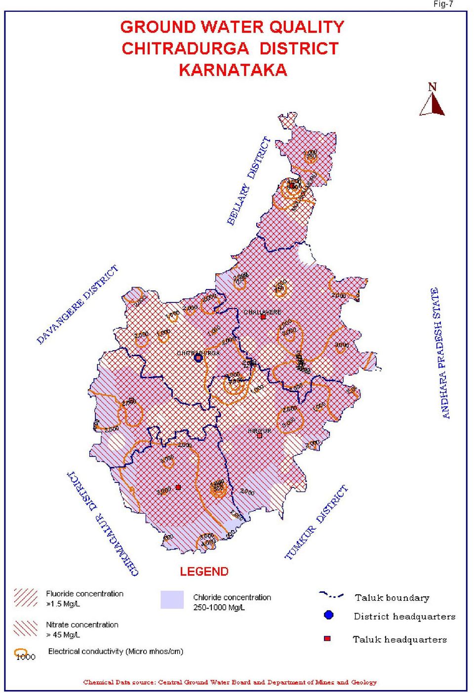
16 to 8.63 mbgl (Figure 5). Seasonal ground water level fluctuation varies from 2.61m to 3.17m. 4.2 Ground Water Resources The resource estimation and categorization is carried out as per the recommendations of GEM-97. As per ground water resource estimation studies (GEM-97), the district is over exploited with a groundwater draft of ham as against the available resource of ham thus the stage of ground water development in the district is 103% (Annexure 1). Major part of the district is falling under overexploited category (Figure 6). However, some parts of the district fall in parts of safe watershed where there is scope for further development. In Holalkere taluk, a small part in the southeast is safe where further ground water development can be taken up. In Challakere taluk, northern half and a small part in the south are over-exploited and rest of the areas is under semi-critical category. In Chitradurga taluk the major part is falling under over-exploited category except a small part in southeast which is under Semi-critical. In Hosdurga, except the western part, which falls under critical category the rest of the taluk is safe and there is scope for ground water development. Molakalmuru taluk, falls under safe category except a small portion on the south, which is over exploited. In Hiriyur taluk, the central part is overexploited and the rest of the area is under semi-critical category. 4.3 Ground Water Quality Ground Water Quality in the district is generally potable and suitable for irrigation and domestic purposes. Electrical conductivity of ground water in general, ranges from 380 to more than 5200 micro mhos /cm at 25 C (Figure 7). The ph value in general ranges from 7.14 to In general ground water is of Carbonate and Bicarbonate type. Chloride varies from 17 mg/l to 1688 mg/l. Fluoride ranges from 0.2 mg/l to 3.6 mg/l. Nitrate ranges from 1 to 530 mg/l. The SAR ranges from 1.1 to 19.5 (Figure 7). 4.4 Status of Ground Water Development Generally, the ground water development in the district is by dug well, dug cum-bore well and bore well. The dug wells for irrigation use are mostly rectangular with dimension ranges of 4m x 6m and 10m x 14m. The depth of these wells ranges from 9m to 15m and some cases at the bottom of the dug well, one or two bore wells are constructed. In addition to this bore well irrigation is also common. The borewells range in depth from 60m to 200m with diameter of 148mm to 165mm. The yield of these bore wells varies from >1 to about 10 lps.
. Major part of the district is falling under overexploited category (Figure 6).")
17

18
19 The stage of groundwater development in the district is quite high. In Chellakere taluk 52% of the area falls under semi critical and 47% under over exploited category. The stage of development of groundwater for the taluk is 110%. In Chitrdurga taluk 27% of the area falls under semi critical and 73% under over exploited category. The stage of groundwater development for the taluk is 127%, which is the highest in the district.. In Hiriyur taluk 68% of the area falls under semi critical and 32% under over exploited category. The stage of groundwater development for the taluk is 104%.. In Holalkere taluk 15% of the area falls under safe and 85% under over exploited category. The stage of development of groundwater for the taluk is 125%.. In Hosadurga taluk 74% of the area falls under safe and 22% under over exploited category. The stage of development of groundwater for the taluk is 79%. In Molakalmuru taluk 91% of the area falls under safe and 9% under over exploited category. The stage of development of groundwater for the taluk is 46% and is the least for the district indicating scope for further development. 5.0 Ground Water Management Strategy 5.1 Ground Water Development Based on the annual ground water availability for future irrigation use, it is proposed that the ground water development structure viz, dug well, dug cum bore wells and bore wells can be constructed in those areas falling under safe & semi critical category. Location of structure may be decided based on local hydro geological condition and topography of the area, after scientific surveys. Dug wells are the ideal structures in weathered rocks. The diameter may be 4.5 to 5m and depth between 15 & 20 m. Bore well from the bottom of dug wells may be constructed to tap the weathered and fractured zone where ever feasible based on hydro geological considerations. These may be drilled up to a depth of 40 to 80m with a dia of extension bore wells in he range of 100 to 152 mm. Bore wells of 152 mm diameter can be constructed from the surface by lowering the casing pipe up to the semi weathered formation and leaving rest of bore well naked. The depth of bore wells in the range of 60 m to 200 m yielding between 2 lps to 10 lps or more can be drilled after scientific investigations for locating the sites 5.2 Water Conservation & Artificial Recharge As per the resource assessment data, major part of the district is falling under over-exploited and critical category. The stage of groundwater development in the district is more than 100%, which requires immediate intervention by way of conservation and artificial recharge to ground water in order to arrest the declining trend in water level. Artificial recharge to ground water through percolation tank, check dams and nalla bunds are the apt solution to mitigate the water scarcity in plain land of the district. The district is blessed with more than 320

20 tanks, of which 20 are large with atchkat of more than 200ha, while 146 are having atchkat of ha and the rest are having atchkat of 4 to 40ha. Many of these tanks are silted and dried up. The rejuvenation of these tanks by desilting and construction of additional percolation tanks will help in recharging the phreatic zone. It is the most practical solution to prolong the onset of drought. Subsurface dykes are suitable along river course, wherever the thickness of the alluvium is more. 6.0 Awareness & Training activity Mass Awareness program was held at Dallara Bhavana, Challakere, Chitradurga district on As a part of the programme, a technical session was also arranged. Documentaries on Artificial recharge Schemes and Rain water harvesting with case studies and quality of ground water were shown. Tips on Rain Water Harvesting were given by the members of self-help and user groups, particularly by Sthree Shakti. Working models of Artificial recharge Schemes and Rain Water Harvesting were exhibited. About 300 Representatives from State Govt., educational institutions and farmer community and NGOs participated in the programme. Water Management Training Programme was held at Zilla Panchayath office, Chitradurga, during 19th and 20th January The Chief guest released the training module. 7.0 Recommendations The district is drought prone and dug wells dry up in extreme summer. To cope up with the situation, the existing dugwells may be deepened and deep dugwells may be converted into dug-cum-borewells to increase the yield. Artificial recharge to ground water through percolation tank structures are the apt solution to mitigate the water scarcity in the district since more than 320 tanks are available through out the district. The rejuvenation of the existing tanks by desilting and construction of additional percolation tanks will help in recharging the phreatic zone. It is one of the most practical solutions to prolong the onset of drought. Large number of abandoned bore wells/dug well can be used to recharge the aquifer utilizing the surplus surface runoff available during rainy days. Selections of site for bore well should be done only on scientific methods as the yield of bore wells are site specific. Further, bore wells in the district have limited scope as a permanent solution to mitigate the drought situation especially for agriculture purposes.

21 Annexure 1. TALUKWISE GROUND WATER RESOURCES OF CHITRADURGA DISTRICT, KARNATAKA AS ON 31ST MARCH 2004 Total Annual GW Recharge Net Annual GW Availability Existing gross GW draft for irrigation Existing gross GW draft for domestic and industrial water supply Existing gross GW draft for all uses Allocation for domestic and industrial use for next 25 years Net GW availability form future irrigation development Average crop water requirement Balance GW irrigation potential available Safe (% area) Semi-critical (%area) Critical (% area) Over-exploited (% area) Stage of development (%) Taluk Challakere Chitradurga Hiriyur Holalkere Hosdurga Molakalmuru
Development of Rural Drinking Water Security Plan A Case Study from Raipur Block, Bhilwara District, Rajasthan
 Development of Rural Drinking Water Security Plan A Case Study from Raipur Block, Bhilwara District, Rajasthan Dr. B. K. Bhadra Scientist/Engr. SF Regional Remote Sensing Centre (RRSC-W) NRSC/ISRO, Dept.
Dr S.K. GUPTA Scientist D Central Ground Water Board. 25 th FEB. 2014
 GROUND WATER SCENARIO AND MANAGEMENT OPNTIONS IN NCR, DELHI Dr S.K. GUPTA Scientist D Central Ground Water Board 25 th FEB. 2014 National Capital Region, Delhi National Capital Region Sl No State District
GOVERNMENT OF INDIA MINISTRY OF WATER RESOURCES CENTRAL GROUND WATER BOARD GROUND WATER INFORMATION BOOKLET KOPPAL DISTRICT, KARNATAKA
 GOVERNMENT OF INDIA MINISTRY OF WATER RESOURCES CENTRAL GROUND WATER BOARD GROUND WATER INFORMATION BOOKLET KOPPAL DISTRICT, KARNATAKA SOUTH WESTERN REGION BANGALORE DECEMBER 2008 FOREWORD Ground water
Influence of various factors on the fluctuation of groundwater level in hard rock terrain and its importance in the assessment of groundwater
 Journal of Geology and Mining Research Vol. 3(11) pp. 305-317, November 2011 Available online at http://www.academicjournals.org/jgmr ISSN 2006-9766 2011 Academic Journals Full Length Research Paper Influence
CHAPTER - X WATER HARVERSTING AND RECHARGING IN HARD ROCK AREAS
 CHAPTER - X WATER HARVERSTING AND RECHARGING IN HARD ROCK AREAS CHAPTER X WATER HARVERSTING AND RECHARGING IN HARD ROCK AREAS 10.0 CONCEPTUAL FRAME WORK From a technical stand point, though hard rock areas
WILLOCHRA BASIN GROUNDWATER STATUS REPORT 2009-10
 WILLOCHRA BASIN GROUNDWATER STATUS REPORT 2009-10 SUMMARY 2009-10 The Willochra Basin is situated in the southern Flinders Ranges in the Mid-North of South Australia, approximately 50 km east of Port Augusta
Domestic Policy Framework on Adaptation to Climate Change in Water Resources: Case Study for India. Working Together to Respond to Climate Change
 Domestic Policy Framework on Adaptation to Climate Change in Water Resources: Case Study for India Working Together to Respond to Climate Change WATER ACCOUNTING OF INDIA S TOTAL WATER RESOURCES Unutilizable
GROUND WATER BROCHURE
 For Official Use Only CENTRAL GROUND WATER BOARD MINISTRY OF WATER RESOURCES GOVERNMENT OF INDIA GROUND WATER BROCHURE CHITTOOR DISTRICT, ANDHRA PRADESH SOUTHERN REGION HYDERABAD September 2013 CENTRAL
Chapter 2 Brief Overview of the Yamuna River Basin and Issues
 Chapter 2 Brief Overview of the Yamuna River Basin and Issues Abstract This chapter presents the current status of the Yamuna river basin as well as brief description of its catchments. This chapter also
WATER RESOURCES OF MAHARASHTRA STATE The geographical area of the state is 30.7Mha. Cultivable area is 22.5 Mha.(73%GA). Out of this 40% area is
. Out of this 40% area is") WATER RESOURCES OF MAHARASHTRA STATE The geographical area of the state is 30.7Mha. Cultivable area is 22.5 Mha.(73%GA). Out of this 40% area is drought prone. About 7% area is flood prone. The highly
WATER RESOURCES OF MAHARASHTRA STATE The geographical area of the state is 30.7Mha. Cultivable area is 22.5 Mha.(73%GA). Out of this 40% area is drought prone. About 7% area is flood prone. The highly
< SUBSURFACE DAMS TO AUGMENT GROUNDWATER STORAGE IN BASEMENT TERRAIN FOR HUMAN SUBSISTENCE BRAZILIAN EXPERIENCE >
 CASE PROFILE COLLECTION No 5 < SUBSURFACE DAMS TO AUGMENT GROUNDWATER STORAGE IN BASEMENT TERRAIN FOR HUMAN SUBSISTENCE BRAZILIAN EXPERIENCE > Stephen Foster September 2002 TASK MANAGERS: Gabriel Azevedo
WATER CONSERVATION TECHNICAL BRIEFS
 WATER CONSERVATION TECHNICAL BRIEFS TB 2 Rainwater Harvesting and Artificial Recharge to Groundwater SAI Platform August 2009 This document has been produced for internal information purposes only among
BASIN MANAGEMENT OBJECTIVES CHEROKEE SUBINVENTORY UNIT
 BASIN MANAGEMENT OBJECTIVES CHEROKEE SUBINVENTORY UNIT Butte County Water Advisory Committee Member John Scott Contact Information Phone Number: (530) 533-8394 Email Address: [email protected] Description
NREGA for Water Management
 National Rural Employment Guarantee Act NREGA for Water Management 30 th October, 2009 Dr. Rita Sharma Secretary to Government of India Ministry of Rural Development NREGA objective supplement wage-employment
DRAFT MODEL BILL FOR THE CONSERVATION, PROTECTION AND REGULATION OF GROUNDWATER
 DRAFT MODEL BILL FOR THE CONSERVATION, PROTECTION AND REGULATION OF GROUNDWATER Preamble Recognising the unitary nature of water and the integration of surface water and groundwater; Recognizing that natural
Water Resources Development and Management in India - An Overview
 Water Resources Development and Management in India - An Overview A presentation by U. N. Panjiar Secretary to the Government of India This presentation Water resources scenario in India Water governance
4 Water supply description
 4 Water supply description A description of the drinking-water system is equally applicable to large utilities with piped distribution systems, piped and non-piped community supplies, including handpumps
Ground-Water-Level Monitoring and the Importance of Long-Term Water-Level Data U.S. Geological Survey Circular 1217
 Ground-Water-Level Monitoring and the Importance of Long-Term Water-Level Data U.S. Geological Survey Circular 1217 by Charles J. Taylor William M. Alley Denver, Colorado 2001 U.S. DEPARTMENT OF THE INTERIOR
Water Resource. 1 Initiating and Sustaining Water Sector Reforms : A Synthesis World Bank in collaboration with the Government of India, Ministry of
 WATER RESOURCES OF INDIA by Kalipada Chatterjee Climate Change Centre Development Alternatives Introduction Water is essential for human civilisation, living organisms, and natural habitat. It is used
How To Map A Lake In The North Of The Holland (Fiji)
") 1. Hydrogelogical mapping Jiri Sima Aim of HG map Groundwater and rocks qualitative permeability and quantitative potential of rock units aquifers / aquitards / aquiclides Water points (spatial distribution
1. Hydrogelogical mapping Jiri Sima Aim of HG map Groundwater and rocks qualitative permeability and quantitative potential of rock units aquifers / aquitards / aquiclides Water points (spatial distribution
U. Vellaiappan 1 * Sr. Project Executive DHAN Foundation Madurai -625 016,Tamilnadu, INDIA Email: [email protected] ABSTRACT
 FARMPOND WITH DRIP IRRIGATION AND OTHER CONVERGENCE SCHEMES SUPPORTS RAINFED AGRICULTURE AS VIABLE FARMING - AN EXPERIENCE OF ORIVAYAL WATERSHED IN RAMANATHAPURAM DISTRICT OF TAMINNADU IN INDIA U. Vellaiappan
STATE OF VERMONT AGENCY OF NATURAL RESOURCES DEPARTMENT OF ENVIRONMENTAL CONSERVATION WASTE MANAGEMENT DIVISION SOLID WASTE MANAGEMENT PROGRAM
 STATE OF VERMONT AGENCY OF NATURAL RESOURCES DEPARTMENT OF ENVIRONMENTAL CONSERVATION WASTE MANAGEMENT DIVISION SOLID WASTE MANAGEMENT PROGRAM Solid Waste Management Program Waste Management Division 103
THE GREAT RUAHA RIVER PROFILE
 THE GREAT RUAHA RIVER PROFILE By Willie Mwaruvanda A Paper presented at the Clivet Project Inception Workshop,Blue Pearl Hotel Ubungo Plaza, Dar es Salaam 27 th November, 2009. 1 The Rufiji Basin Tanzania
MCLAREN VALE PWA GROUNDWATER LEVEL AND SALINITY STATUS REPORT 2009 10
 MCLAREN VALE PWA GROUNDWATER LEVEL AND SALINITY STATUS REPORT 2009 10 SUMMARY 2009 10 The McLaren Vale PWA is located approximately 35 km south of Adelaide. It is a regional-scale resource for which groundwater
Ground Water in the Piedmont and Blue Ridge Provinces of North Carolina
 Ground Water in the Piedmont and Blue Ridge Provinces of North Carolina Prepared by: R.L. Huffman Extension Agricultural Engineering Specialist Published by: North Carolina Cooperative Extension Service
Hydrogeology Experiment on Surface-Groundwater Interactions: How Do Our Actions Affect Water Quantity and Quality?
 Name: Period: Hydrogeology Experiment on Surface-Groundwater Interactions: How Do Our Actions Affect Water Quantity and Quality? Purpose/Objective: Students will learn how groundcover influences surface
Water Management by Panchayat Raj institutions in Alappuzha District
 Water Management by Panchayat Raj institutions in Alappuzha District Introduction 3.3.1 Water is one of the most important physical requirements of human beings. Communities and individuals use water resources
GUIDELINES FOR REPAIR, RENOVATION AND RESTORATION
 GUIDELINES FOR REPAIR, RENOVATION AND RESTORATION OF WATER BODIES WITH DOMESTIC SUPPORT Government of India Ministry of Water Resources 2009 I N D E X CONTENTS PAGE NO. 1. Introduction 1 2. Basic Features
COMPREHENSIVE PLAN SECTION B, ELEMENT 4 WATER RESOURCES. April 20, 2010 EXHIBIT 1
 COMPREHENSIVE PLAN SECTION B, ELEMENT 4 WATER RESOURCES April 20, 2010 EXHIBIT 1 ELEMENT 4 WATER RESOURCES TABLE OF CONTENTS 4.1 INTRODUCTION 4.2 GOALS AND POLICIES 4.2.A General Goals and Policies 1 4.2.B
COST AND PERFORMANCE REPORT
 COST AND PERFORMANCE REPORT Pump and Treat of Contaminated Groundwater at the United Chrome Superfund Site Corvallis, Oregon September 1998 Prepared by: SITE INFORMATION Identifying Information: United
ESSENTIAL COMPONENTS OF WATER-LEVEL MONITORING PROGRAMS. Selection of Observation Wells
 ESSENTIAL COMPONENTS OF WATER-LEVEL MONITORING PROGRAMS Before discussing the uses and importance of long-term water-level data, it is useful to review essential components of a water-level monitoring
LDPCSD Water Supply Emergency Response Plan Status Update 2-4-15
 LDPCSD Water Supply Emergency Response Plan Status Update 2-4-15 1 EMERGENCY OVERVIEW The Lake Don Pedro Community Services District (LDPCSD) provides domestic potable water service to 1450 connections
GROUNDWATER CONDITIONS
 GROUNDWATER CONDITIONS IN THE NORTHERN SACRAMENTO VALLEY LOCAL MANAGEMENT OF WATER RESOURCES IN THE NORTHERN SACRAMENTO VALLEY MEETING DECEMBER 16, 2011 KELLY STATON, SENIOR ENGINEERING GEOLOGIST, GROUNDWATER
PRESENTATION. Improving the performance of Public Water Utilities A case study of Bangalore N.C. MUNIYAPPA, Chairman, BWSSB LOCATION MAP OF BANGALORE
 Arabian Sea Mumbai KARNATAKA Delhi Chennai Nepal Calcutta Bay of Bengal PRESENTATION Improving the performance of Public Water Utilities A case study of Bangalore By N.C. MUNIYAPPA, Chairman, BWSSB LOCATION
An Investigation of Groundwater Quality and Its Suitability to Irrigated Agriculture in Coimbatore District, Tamil Nadu, India A GIS Approach
 An Investigation of Groundwater Quality and Its Suitability to Irrigated Agriculture in Coimbatore District, Tamil Nadu, India A GIS Approach Balachandar. D 1, Sundararaj P. 1, Rutharvel Murthy K. 1 Kumaraswamy
Module 1. Principles of Water Resources Engineering. Version 2 CE IIT, Kharagpur
 Module 1 Principles of Water Resources Engineering Lesson 2 Concepts for Planning Water Resources Development Instructional Objectives On completion of this lesson, the student shall be able to know: 1.
PRSENTATION ON DRAINAGE SYSTEM DELHI 25.07.2014 EAST DELHI MUNICIPAL CORPORATION
 PRSENTATION ON DRAINAGE SYSTEM OF DELHI EAST DELHI MUNICIPAL CORPORATION 25.07.2014 MAP OF DELHI SHOWING MCD s, NDMC & DCB ABOUT DELHI DELHI MANIFESTS UNCONTROLLED URBANISATION POPULATION INDUSTRIALISATION
GOVERNMENT OF KARNATAKA SCHEMES FOR RURAL DEVELOPMENT AND PANCHAYAT RAJ
 GOVERNMENT OF KARNATAKA SCHEMES FOR RURAL DEVELOPMENT AND PANCHAYAT RAJ 1. SCHEMES OF DEPARTMENT OF RURAL DEVELOPMENT & PANCHAYAT RAJ For more details, please visit http://rdpr.kar.nic.in/ Sl No Name of
Ground Water Surveys and Investigation
 Ground Water Surveys and Investigation By Gautam Mahajan ASHISH PUBLISHING HOUSE 8/81, PUNJABI BAGH, NEW DELHI-110 026 - Contents Preface List of Abbrivations (v) (vii) 1.1 1.2 1.3 1.4 1.5 1.6 1.7 1.7.1
Burnt River Black River and Gull River Flood Contingency Plan
 Burnt River Black River and Gull River Flood Contingency Plan Objective: The objective of this plan is to preplan and prepare for flooding events in the Burnt River, Black River and Gull River area of
VILLAGE WATER SECURITY PLAN
 VILLAGE WATER SECURITY PLAN UPPER KITAM AND MIDDLE KITAM GRAM PANCHAYAT WARD Manpur Kitam Gram Panchayat Unit Gram Vikas Kendra, Namchi, South Sikkim April 2014 Contents Introduction 03 Village Profile
THE ECOSYSTEM - Biomes
 Biomes The Ecosystem - Biomes Side 2 THE ECOSYSTEM - Biomes By the end of this topic you should be able to:- SYLLABUS STATEMENT ASSESSMENT STATEMENT CHECK NOTES 2.4 BIOMES 2.4.1 Define the term biome.
Landslide Hazard Zonation Mapping Using GIS
 1 Weerasinghe K. M. 1 Landslide Hazard Zonation Mapping Using GIS Abstract: The central highlands of Sri Lanka comprising 20% of the total land area of the country is often threatened by landslides. The
SWAT INPUT DATA:.GW CHAPTER 24
 CHAPTER 24 SWAT INPUT DATA:.GW SWAT partitions groundwater into two aquifer systems: a shallow, unconfined aquifer which contributes return flow to streams within the watershed and a deep, confined aquifer
4 th WORLD WATER FORUM. Risk Management in the Iullemeden Aquifer System. 4th World Water Forum, Mexico 2006
 4 th WORLD WATER FORUM Risk Management in the Iullemeden Aquifer System Mexico, Marsh 17 th, 2006 GEOGRAPHIC OVERVIEW IAS OVERVIEW Countries : Mali, Niger, Nigeria Mali Area : 525 000 km² Mali : 31000
London Borough of Waltham Forest LOCAL FLOOD RISK MANAGEMENT STRATEGY. Summary Document
 LOCAL FLOOD RISK MANAGEMENT STRATEGY Summary Document October 2013 Local Flood Risk Management Strategy Summary 1 Introduction 2 Partner responsibilities 3 What do we know about flooding in the borough?
Definition and Categorization of Small-scale Water Infrastructure
 Definition and Categorization of Small-scale Water Infrastructure Aidan Senzanje, Timoth E Simalenga and Jabulani Jiyane Technical Brief No. 01 February 2012 ACKNOWLEDGEMENTS This study was funded by Consultative
2. Mahatma Gandhi National Rural Employment Guarantee Act (MGNREGA)
") 2. Mahatma Gandhi National Rural Employment Guarantee Act (MGNREGA) I. Background Evolving the design of the wage employment programmes to more effectively fight poverty, the Central Government formulated
2. Mahatma Gandhi National Rural Employment Guarantee Act (MGNREGA) I. Background Evolving the design of the wage employment programmes to more effectively fight poverty, the Central Government formulated
Drought in the Czech Republic in 2015 A preliminary summary
 Drought in the Czech Republic in 2015 A preliminary summary October 2015, Prague DISCLAIMER All data used in this preliminary report are operational and might be a subject of change during quality control.
CHAPTER 9 CONCLUSIONS AND RECOMMENDED MITIGATION
 CHAPTER 9 CONCLUSIONS AND RECOMMENDED MITIGATION 9.1 Conclusions Based on the stability cross-sections down the SE flank of Snodgrass Mountain, most landslides on low- to moderate-gradient slopes have
Planning Resource Guide. Climate Change Adaptation through Land Use Planning
 Planning Resource Guide Climate Change Adaptation through Land Use Planning i The new Provincial Planning regulation continues to promote sound land use planning and express the provincial interest in
EU China River Basin Management Programme
 Ministry of Water Resources Ministry of Environmental Protection EU China River Basin Management Programme Technical Report 075 Water Resource Supply Security Strategy Analysis Ben Piper, Zhang Wang and
GROUNDWATER RESOURCES MANAGEMENT IN SAUDI ARABIA
 GROUNDWATER RESOURCES MANAGEMENT IN SAUDI ARABIA Walid A. Abderrahman Professor, Water Resources Management President, Saudi Water Association Special Presentation at Water Conservation Workshop Khober,
Lars-Göran Gustafsson, DHI Water and Environment, Box 3287, S-350 53 Växjö, Sweden
 Alternative Drainage Schemes for Reduction of Inflow/Infiltration - Prediction and Follow-Up of Effects with the Aid of an Integrated Sewer/Aquifer Model Introduction Lars-Göran Gustafsson, DHI Water and
APPLICATION OF GEOSPATIAL TECHNOLOGIES FOR SUSTAINABLE ENVIRONMENTAL MANAGEMENT
 APPLICATION OF GEOSPATIAL TECHNOLOGIES FOR SUSTAINABLE NATURAL RESOURCES AND ENVIRONMENTAL MANAGEMENT IN MALAYSIA By James Dawos Mamit, Ph.D. Deputy Minister Ministry of Natural Resources and Environment,
Chapter 9: Water, Hydrology and Drainage Land West of Uttoxeter
 Chapter 9: Water, Hydrology and Drainage Land West of Uttoxeter ENVIRONMENTAL STATEMENT: VOLUME 1 9.1 INTRODUCTION 9.1.1 This Chapter considers the effects of the Project on surface water and groundwater
Climate change impacts on city of Gdansk and its vicinity (Vistula Delta, Poland)
") Final International ASTRA Conference Espoo, 10-11 December, 2007 Climate change impacts on city of Gdansk and its vicinity (Vistula Delta, Poland) Dorota Kaulbarsz, Zbigniew Kordalski, Wojciech Jeglinski
Final International ASTRA Conference Espoo, 10-11 December, 2007 Climate change impacts on city of Gdansk and its vicinity (Vistula Delta, Poland) Dorota Kaulbarsz, Zbigniew Kordalski, Wojciech Jeglinski
River Basin Management in Croatia
 River Basin Management in Croatia 2. INTERNATIONAL RIVER BASIN MANAGEMENT HIGH LEVEL SYMPOSIUM Cappadocia/NEVŞEHİR, Turkey 16-18 April 2013 2 Water sector responsibilities are shared among: Croatian Parliament
CHECK DAMS A WATER HARVESTING TECHNIQUE FOR SUSTAINABLE AGRICULTURAL DEVELOPMENT
 CHECK DAMS A WATER HARVESTING TECHNIQUE FOR SUSTAINABLE AGRICULTURAL DEVELOPMENT STUDY TEAM 1. Mr. Barry Underwood 2. Dr. (Mrs.) Sulbha Khanna 3. Ms. Meenakshi G. Angadi 4. Mr. Vishnubhai Patel 5. Mr.
GUIDELINES FOR THE CONTINUATION OF SCHEME ON REPAIR, RENOVATION AND RESTORATION (RRR) OF WATER BODIES IN XII TH PLAN
 OF WATER BODIES IN XII TH PLAN") GUIDELINES FOR THE CONTINUATION OF SCHEME ON REPAIR, RENOVATION AND RESTORATION (RRR) OF WATER BODIES IN XII TH PLAN Government of India Ministry of Water Resources October, 2013 I N D E X PARA NO. CONTENTS
GUIDELINES FOR THE CONTINUATION OF SCHEME ON REPAIR, RENOVATION AND RESTORATION (RRR) OF WATER BODIES IN XII TH PLAN Government of India Ministry of Water Resources October, 2013 I N D E X PARA NO. CONTENTS
Vulnerability Assessment
 Vulnerability Assessment VULNERABILITY As used in this report, vulnerability refers to the sensitivity of groundwater to contamination, and is determined by intrinsic characteristics of the aquifer. It
FARM A SYST Farmstead Assessment System. Drinking Water Well Condition
 G3536 1W FARM A SYST Farmstead Assessment System Worksheet #1 Assessing the Risk of Groundwater Contamination from Why should I be concerned? Drinking Water Well Condition About 95 percent of this country
Water Recycles poster
 Water Recycles poster The "Water ReCycles" poster is designed for students of all ages. It shows the natural water cycle and humans influence on water resources. Raincloud illustration The raincloud in
2x800 MW Thermal Power Project Near Village Paraspani, Tehsil Pathargama, Godda- District By Adani Power (Jharkhand) Limited
 Limited") (IV) Proposed Terms of Reference for EIA Studies Project Category Project Proponent Location Paraspani Thermal Power Plant (2x800 MW) Coal based Thermal Power Project A [1(d) Thermal Power Plant 500 MW]
(IV) Proposed Terms of Reference for EIA Studies Project Category Project Proponent Location Paraspani Thermal Power Plant (2x800 MW) Coal based Thermal Power Project A [1(d) Thermal Power Plant 500 MW]
Description of Simandou Archaeological Potential Model. 13A.1 Overview
 13A Description of Simandou Archaeological Potential Model 13A.1 Overview The most accurate and reliable way of establishing archaeological baseline conditions in an area is by conventional methods of
Newsletter #5: Groundwater In The National Water Balance
 Email not displaying correctly? View it in your browser. Newsletter #5: Groundwater In The National Water Balance How Much Groundwater Does South Africa Have? This fundamental question was the title of
Local Water Supply, Sanitation and Sewage
 Local Water Supply, Sanitation and Sewage Country Report Turkey November 2005 "This report has been produced with the assistance of the European Union. The contents of this document is the sole responsibility
Flash Flood Science. Chapter 2. What Is in This Chapter? Flash Flood Processes
 Chapter 2 Flash Flood Science A flash flood is generally defined as a rapid onset flood of short duration with a relatively high peak discharge (World Meteorological Organization). The American Meteorological
Hydrogeological characteristics of Deccan trap formations of India
 Hard Rock Hydrosysteins (Proceedings of Rabat Symposium S2, May 1997). IAHS Publ. no. 241, 1997 75 Hydrogeological characteristics of Deccan trap formations of India B. B. S. SINGHAL Department of Earth
Settlement of Foundations on Expansive Clays Due to Moisture Demand of Trees CIGMAT 2008
 Settlement of Foundations on Expansive Clays Due to Moisture Demand of Trees CIGMAT 2008 Kenneth E. Tand, P.E. Practicing Geotechnical Engineer FRIEND OR FOE Trees are our friends. They extract carbon
How To Conduct An Environmental Impact Assessment
 Proposed Terms of Reference for EIA studies 1. Introduction The proposed expansion of Bulk Drugs & Intermediates manufacturing unit by M/s. Sri Krishna Pharmaceuticals Limited (Unit V). is located at Plot
Water Resource Plan 2015 (Summary Report) Ensuring customers have clear, fresh, safe drinking water to 2040 and beyond
 Ensuring customers have clear, fresh, safe drinking water to 2040 and beyond") () Ensuring customers have clear, fresh, safe drinking water to 2040 and beyond November 2014 Overview Our Water Resource Plan sets out our strategy to secure the reliable supply of drinking water to
() Ensuring customers have clear, fresh, safe drinking water to 2040 and beyond November 2014 Overview Our Water Resource Plan sets out our strategy to secure the reliable supply of drinking water to
(http://www.molevalley.gov.uk/media/pdf/c/r/srfa_-_updated_jnauary_2012.pdf
 Possible Submission about Water and Flooding (See maps 3a and 3b) From Mole Valley Local Development Framework: Strategic Flood Risk Assessment Update 2012 (http://www.molevalley.gov.uk/media/pdf/c/r/srfa_-_updated_jnauary_2012.pdf
edms 5. THAILAND 5.1 Water Resources Management Policies and Actions
 5. THAILAND 5.1 Water Resources Management Policies and Actions In Thailand, the Office of Natural Resources and Environmental Policy and Planning issued the State of Environment Report 2004, which has
The Alternatives of Flood Mitigation in The Downstream Area of Mun River Basin
 The Alternatives of Flood Mitigation in The Downstream Area of Mun River Basin Dr.Phattaporn Mekpruksawong 1, Thana Suwattana 2 and Narong Meepayoong 3 1 Senior Civil Engineer, Office of Project Management,
Optimizing Water Resources Allocation System and Improving Water Resources Supply Capacity
 Optimizing Water Resources Allocation System and Improving Water Resources Supply Capacity Zhang Shiwei Department of Planning and Programming Ministry of Water Resources, P.R.China May. 2015 Contents
EXPLAINING GROUNDWATER AND WATER WELLS
 EXPLAINING GROUNDWATER AND WATER WELLS This document aims to provide a non-technical description of groundwater: how it occurs, how it moves underground, and the basic principles behind constructing and
Frequently Asked Questions (FAQs) on Hydropower
 on Hydropower") Frequently Asked Questions (FAQs) on Hydropower What are the advantages of Hydropower? A renewable source of energy - saves scarce fuel reserves. Non-polluting and hence environment friendly. Long life
Frequently Asked Questions (FAQs) on Hydropower What are the advantages of Hydropower? A renewable source of energy - saves scarce fuel reserves. Non-polluting and hence environment friendly. Long life
Climate Change and Infrastructure Planning Ahead
 Climate Change and Infrastructure Planning Ahead Climate Change and Infrastructure Planning Ahead Infrastructure the physical facilities that support our society, such as buildings, roads, railways, ports
Type of Sewer Systems. Solomon Seyoum
 Type of Sewer Systems Solomon Seyoum 0 Learning objectives Upon completion of this lecture, the participants will be able to differentiate between types of sewer systems and discuss different aspects of
City of Fort Collins Water Supply and Demand Management Policy
 City of Fort Collins Water Supply and Demand Management Policy The City of Fort Collins Water Supply and Demand Management Policy provides a foundational framework for water supply and demand management
Roosevelt Water Conservation District ROOSEVELT WATER CONSERVATION DISTRICT
 ROOSEVELT WATER CONSERVATION DISTRICT RESPONSE TO ARIZONA POWER AUTHORITY REQUEST FOR INFORMATION DATED SEPTEMBER 12, 2012 PRESENTED OCTOBER 24, 2012 RWCD is an irrigation district that was established
Technology Fact Sheet for Mitigation B. Small Hydropower Technology i 1. Introduction 1.1. Historical - All over the World, hydropower sector is
 Technology Fact Sheet for Mitigation B. Small Hydropower Technology i 1. Introduction 1.1. Historical - All over the World, hydropower sector is playing a great role in economic development since the last
Presentation from the 2013 World Water Week in Stockholm
 Presentation from the 2013 World Water Week in Stockholm www.worldwaterweek.org The Author(s), all rights reserved www.siwi.org Restoration of ecosystem by reallocation of water resources in Shiyanghe
Guidelines For Sealing Groundwater Wells
 Guidelines For Sealing Groundwater Wells Government of Newfoundland and Labrador Department of Environment and Conservation Water Resources Management Division Government of Newfoundland and Labrador Department
CALIFORNIA AMERICAN WATER LOS ANGELES DISTRICT 2009 GENERAL RATE CASE CHAPTER: 1 INTRODUCTION AND SUMMARY OF APPLICATION
 DISCUSSION OF INFORMATION PRESENTED IN THIS CHAPTER This chapter contains information regarding the operation of the Los Angeles District of California American Water as well as tables that summarize the
Chapter 18 Introduction to. A f r i c a
 Chapter 18 Introduction to A f r i c a Ch. 18:1 Landforms & Resources 1. Africa s shape & landforms are the result of its location in the southern part of the ancient supercontinent of. Pangaea Over thousands
GUIDELINES FOR THE CONTINUATION OF SCHME ON REPAIR, RENOVATION AND RESTORATION (RRR) OF WATER BODIES IN XII TH PLAN
 OF WATER BODIES IN XII TH PLAN") GUIDELINES FOR THE CONTINUATION OF SCHME ON REPAIR, RENOVATION AND RESTORATION (RRR) OF WATER BODIES IN XII TH PLAN Government of India Ministry of Water Resources October, 2013 I N D E X PARA NO. CONTENTS
GUIDELINES FOR THE CONTINUATION OF SCHME ON REPAIR, RENOVATION AND RESTORATION (RRR) OF WATER BODIES IN XII TH PLAN Government of India Ministry of Water Resources October, 2013 I N D E X PARA NO. CONTENTS
Insurance environment in India: Bottlenecks and opportunities for a cost effective insurance products. Srinivasa Rao Gattineni
 Insurance environment in India: Bottlenecks and opportunities for a cost effective insurance products Srinivasa Rao Gattineni Rainfall variability is dominant due to the presence of the Monsoon (seasonal
NATIONAL WATER POLICY (2012)
") Government of India Ministry of Water Resources NATIONAL WATER POLICY (2012) 1. PREAMBLE 1.1 A scarce natural resource, water is fundamental to life, livelihood, food security and sustainable development.
Government of India Ministry of Water Resources NATIONAL WATER POLICY (2012) 1. PREAMBLE 1.1 A scarce natural resource, water is fundamental to life, livelihood, food security and sustainable development.
AQUIFER STORAGE RECOVERY
 AQUIFER STORAGE RECOVERY This continuing education unit has been created to acquaint the reader with the topic of Aquifer Storage Recovery. The International School of Well Drilling gratefully acknowledges
Water Statistics in Brazil: an Overview
 Water Statistics in Brazil: an Overview By Judicael Clevelario Junior, Valdir Neves, Paula Terezina Tudesco Macedo de Oliveira Valéria Grace Costa Pedro Amendola Roberval M. Rocha Júlio Jorge Gonçalves
Ponds- Planning, Design, Construction
 United States Department of Agriculture Soil Conservation Service Agriculture Handbook Number 590 Ponds- Planning, Design, Construction This handbook describes the requirements for building a pond. It