APPLICATION OF GEOSPATIAL TECHNOLOGIES FOR SUSTAINABLE ENVIRONMENTAL MANAGEMENT
|
|
|
- Daniel Lindsey
- 7 years ago
- Views:
Transcription
1 APPLICATION OF GEOSPATIAL TECHNOLOGIES FOR SUSTAINABLE NATURAL RESOURCES AND ENVIRONMENTAL MANAGEMENT IN MALAYSIA By James Dawos Mamit, Ph.D. Deputy Minister Ministry of Natural Resources and Environment, Malaysia 1

2 Total Land Area: 330,290 sq. km 13 States & 3 Federal Territories Sabah Peninsular Sarawak 2

3 For identifying abundance and locations of natural resources. For determining strategic plan and sound management practices for extraction of natural resources. For identifying impacts of exploitation of natural resources on environmental health. For expedient and quick decisions and actions. 3

4 Natural Resources in Malaysia 4

5 Mineral Resource Forest Resource Water Resource 5

6 Peninsular Malaysia: mil. ha. Sabah: mil. ha. Sarawak: mil. ha. Total: mil. ha. Permanent Forest Reserve: mil. ha. Peninsular mil. ha., Sabah mil. ha., Sarawak mil. ha. 6

7 Mangrove Forest Beach/Littoral Forest Peat Swamp Forest Lowland Mixed Dipterocarp Forest Hill Mixed Dipterocarp Forest Montane and Sub- Montane Forest 7

8 Forest Industry contributed USD6.73 bil. to GDP and availed job opportunities to 500,000 Malaysians in

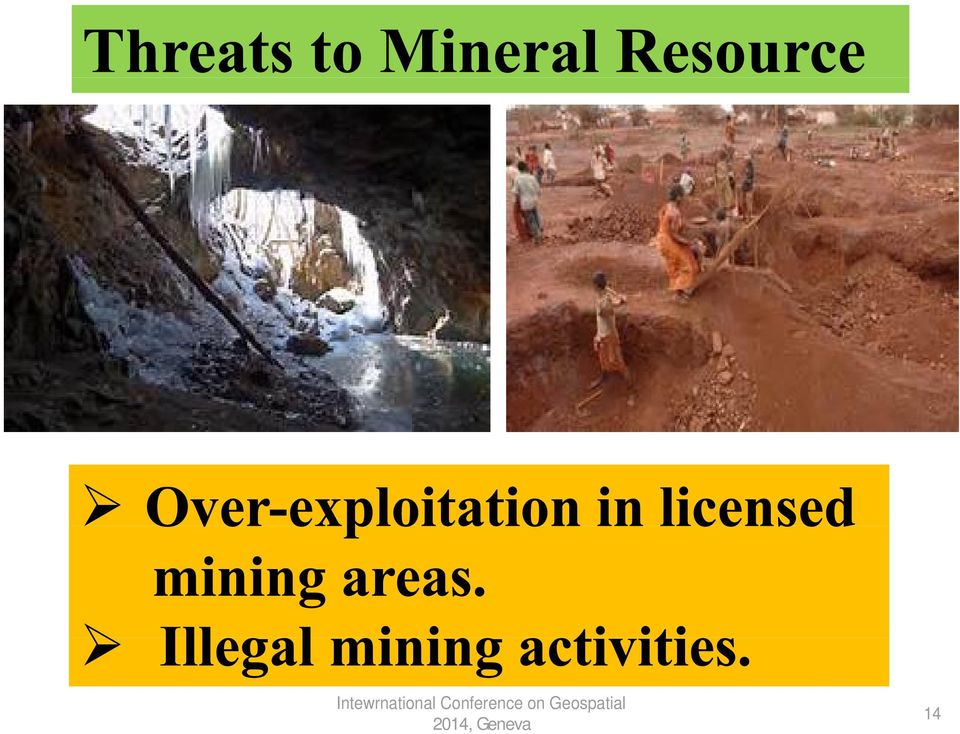
9 Over-exploitation in licensed concession areas Illegal Forest Harvesting: 647 cases till 2013, Incurring losses USD10.91 mil. 9

10 Remoteness and Inaccessibility 10

11 Metals: Bauxite Gold Ilmenite Iron Ore Manganese Rare Earth Rutile Tin Silver Struverite Zirkon Non-Metals: Rock Aggregates Clay Coal Feldspar Kaolinite Limestone Mica Sand and Gravels Silica Sand 11

12 Silica Sand 155,800,000 m/tons Kaolinite 117,180,000 m/tons Coal 970,570,000 m/tons Iron Ores 50,000,00 m/tons 12

13 Industry Performance: Mining and Quarrying Sector contributed USD2.09 bil. or 1.06% to GDP in mines in 2011 Intewrnational Conference on 7,053 Geospatial workers 13

14 14
15 Most valuable natural asset to humans 15

16 Annual Rainfall: 990 bil. m 3 Surface Runoff: 566 bil. m 3 Evapo-transpiration: 360 bil. m 3 Groundwater Recharge: 64 bil. m 3 Surface Artificuial Storage: 25 bil. m 3 (Dams) Groundwater Storage: 5,000 bil. m 3 (Aquifers) 16

17 Climate Change Unplanned developments Uncontrolled physical activities by individuals and groups Unethical actions Polluted and Degraded Quality 17

18 Current River Water Pollution: Out of 464 rivers, 59% clean 34% polluted 7% severely polluted 18

19 Putative relationship between forests and rainfall, i.e., decline in forest cover causes disruption in rainfall regimes (4% decline). Soil is less protected from torrential rains in denuded areas, causing severe surface run-offs and erosion. Much higher daily variation in ground temperature in denuded areas. Biodiversity loss. 19

20 Impact of Forest Exploitation on Hydrological System High river sedimentation loads and turbidity; landslides can increase river sediment loads by 5- to 50-fold directly after logging. Elevated sediment loads impair fish habitat, heighten flood risk downstream, alter river-flow direction and speed, and increase costs of treatment for potable water Supplies. 20

21 Discharge of mine effluent into rivers. Seepage from tailings and waste rock impoundments. Sedimentation of rivers caused by poorly built roads during exploration and mine construction. Various chemicals for processing finely ground ore-tailings discharfed into rivers. 21
22 Remoteness and Inaccessibility: How Intewrnational and Conference what on Geospatial to do??? 22
23 Geospatial technology is an essential component of Natural Resources Management Tools, as natural resources are directly affected by changes in the shape and extent of the proposed disturbances. 23
24 The methods used for the measurement, analysis and visualization of features and phenomena that occur on Earth. Three commonly used technologies: Global Positioning Systems (GPS) Geographical Information Systems (GIS) Remote Sensing (RS) 24
25 Geospatial technologies provide the means to integrate diverse datasets based on their geospatial attributes, thus allowing for holistic analysis. Geospatial technologies make it possible to observe remote and inaccessible places, thus making accurate and timely spatially distributed datasets readily available (eg., open burning). 25
26 USES GPS is a network of 2 dozens satellites, transmitting signals to GPS receivers, allowing them to determine location, direction and speed. Geodetic control for surveying, engineering, mapping Cadastr Intewrnational Conference survey on Geospatial 26
27 Forest Resource and Environment: Land area and coverage, soil types, species composition, topography, hydrography, infrastructure, rainfall. Mineral Resource: Land area, soil chemistry, topography, rock formations and physical properties. Water Resource: Hydrography, aquifers and ground water, topography. 27
28 Science and Techniques of obtaining geospatial information about a phenomenon without in contact with it (e.g., flood) 28
29 RS Applications for Natural Resources Management FORESTRY: MINING: WATER Identifying forest types and Species Identifying rock formations RESOURCE: Determination of water Estimating timber and minerals Estimating boundaries and surface areas volume and yield mineral reserves Mapping of floods ENVIRONMENT: Monitoring and flood plains land degradation and pollution, water pollution, air pollution, open burning, impact of natural disasters 29
30 Over-exploitation. Non-compliance to Forest Management Plan and Logging Prescriptions, such as prescribed uration of logging, cutting cycle, tree size. 30
31 State of Sarawak Scenario 31
32 Determining productivity, safety hazard issues, compliance to laws and regulations, adherence to work Plans. 32
33 Determining quantity and quality 33
34 Knowledge, represented by using and analysing a series of geospatial information datasets. Geospatial information that are the sum of our intepretation and synthesis of datasets. We cannot provide relevant geospatial information without fundamental datasets, including interrelationship between these datasets, the management of datasets, and the means of accessing and distributing those datasets. 34
35 Land degradation, Natural disasters, Biodiversity loss. Water Quality: 59% clean, 34% polluted, 7% severly polluted. Terrestrial Ecosystem Inland Water Aquatic Ecosystem 35
36 Using Geospatial Information to Develop Integrated Management Plan for Natural Resources and Environment Geospatial technologies are used for inventory, delineation and mapping of natural resources: Production Forests Protected Areas and Wetlands Wildlife Reserves Mining Sites and Mineral Reserves Water Resource and Pollution 36
37 Utilization of Geospatial Technologies is based on: Types of information to be delivered Users needs 37
38 Geospatial Technologies are vital for Sustainable Management of Natural Resources and the Environment for purposes of expedient and accurate decision-making 38
39 39
THE NATURAL RESOURCES AND ENVIRONMENT ORDINANCE (CAP. 84 - LAWS OF SARAWAK, 1958 Ed.)
") THE NATURAL RESOURCES AND ENVIRONMENT ORDINANCE (CAP. 84 - LAWS OF SARAWAK, 1958 Ed.) THE NATURAL RESOURCES AND ENVIRONMENT (PRESCRIBED ACTIVITIES) ORDER, 1994 (Made under section 11A(1)) (Incorporating
THE NATURAL RESOURCES AND ENVIRONMENT ORDINANCE (CAP. 84 - LAWS OF SARAWAK, 1958 Ed.) THE NATURAL RESOURCES AND ENVIRONMENT (PRESCRIBED ACTIVITIES) ORDER, 1994 (Made under section 11A(1)) (Incorporating
Elizabeth Curmi, Keith Richards, Richard Fenner, Julian.M Allwood, Bojana Bajželj and Grant M. Kopec
 A new representation of integrated management of water resources: Sankey diagrams that link water sources and services for humans and nature at different scales Elizabeth Curmi, Keith Richards, Richard
Unit 6: Homework Questions
 1. The most sustainable type of development is: A) dispersed development B) compact development C) satellite development D) corridor development E) strip development 2. Urban sprawl is synonymous with
WATER AND DEVELOPMENT Vol. II - Types Of Environmental Models - R. A. Letcher and A. J. Jakeman
 TYPES OF ENVIRONMENTAL MODELS R. A. Letcher and A. J. Jakeman Centre for Resource and Environmental Studies, The Australian National University, Australia Keywords: environmental models, environmental
How To Map A Lake In The North Of The Holland (Fiji)
") 1. Hydrogelogical mapping Jiri Sima Aim of HG map Groundwater and rocks qualitative permeability and quantitative potential of rock units aquifers / aquitards / aquiclides Water points (spatial distribution
1. Hydrogelogical mapping Jiri Sima Aim of HG map Groundwater and rocks qualitative permeability and quantitative potential of rock units aquifers / aquitards / aquiclides Water points (spatial distribution
Restoration Planning and Development of a Restoration Bank
 Restoration Planning and Development of a Restoration Bank Black Creek Pioneer Village, South Theatre 8:30 a.m. to 3:30 p.m. Habitat Restoration and Environmental Monitoring Projects Section Restoration
Environmental Law Enforcement in Zimbabwe. Farai Michael Nyahwa
 Environmental Law Enforcement in Zimbabwe By Farai Michael Nyahwa Presentation Breakdown Institutional Arrangement for Environmental Law Enforcement in Zimbabwe Major Environmental Issues of Concern In
Water Forever: South West Margaret River Forum
 Questions from the MRREC 1. How much water is currently being taken from each well/bore and region in the South West? This is a question for the water regulator the Department of Water. Please note information
Responding to the Challenges of Water Security: the VIII Phase of the International Hydrological Programme 2014-2021
 3rd UNECWAS Annual Seminar 21st of August, TUT Responding to the Challenges of Water Security: the VIII Phase of the International Hydrological Programme 2014-2021 Blanca Jimenez-Cisneros Director of the
Revising the Nantahala and Pisgah Land Management Plan Preliminary Need to Change the Existing Land Management Plan
 Revising the Nantahala and Pisgah Land Management Plan Preliminary Need to Change the Existing Land Management Plan Throughout the Plan 1. There is a fundamental need for the revised plan to address how
4. Environmental Impacts Assessment and Remediation Targets
 4. Environmental Impacts Assessment and Remediation Targets 4.1 Environmental Impacts Significant additional development in the Alder Creek watershed is not anticipated at this time; however, there are
APPENDIX I (See Paragraph -6) FORM I
 FORM I") APPENDIX I (See Paragraph -6) FORM I (I) Basic Information: Sl.. Item Details 1 Name of the project/s Removal of sand from Sand bar SB-G2 2 S.. in the schedule G 3 Proposed capacity / area/length / tonnage
APPENDIX I (See Paragraph -6) FORM I (I) Basic Information: Sl.. Item Details 1 Name of the project/s Removal of sand from Sand bar SB-G2 2 S.. in the schedule G 3 Proposed capacity / area/length / tonnage
Global Water Resources
 Global Water Resources Highlights from assessment activities over the past two decades, which are used to establish present and future water trends, reveal that: 1. Freshwater resources are unevenly distributed,
FOUR RIVERS RESTORATION PROJECT
 MLTM Republic of Korea Making Every Drop Count International Workshop on Integrated Urban Water Management WATER & GREEN GROWTH FOUR RIVERS RESTORATION PROJECT Office of National River Restoration, Korea
Amherst County Public Schools. AP Environmental Science Curriculum Pacing Guide. College Board AP Environmental Science Site
 Amherst County Public Schools AP Environmental Science Curriculum Pacing Guide College Board AP Environmental Science Site REV: 8/12 1 st 9 weeks AP Objectives Energy Resources and Consumption A. Energy
BLACK/HARMONY/FAREWELL CREEK WATERSHED EXISTING CONDITIONS REPORT CHAPTER 12 - STORMWATER MANAGEMENT
 Harmony Creek subwatershed Harmony Creek subwatershed BLACK/HARMONY/FAREWELL CREEK WATERSHED EXISTING CONDITIONS REPORT CHAPTER 12 - STORMWATER MANAGEMENT April 2011 TABLE OF CONTENTS 1.0 INTRODUCTION...
4 th WORLD WATER FORUM. Risk Management in the Iullemeden Aquifer System. 4th World Water Forum, Mexico 2006
 4 th WORLD WATER FORUM Risk Management in the Iullemeden Aquifer System Mexico, Marsh 17 th, 2006 GEOGRAPHIC OVERVIEW IAS OVERVIEW Countries : Mali, Niger, Nigeria Mali Area : 525 000 km² Mali : 31000
2x800 MW Thermal Power Project Near Village Paraspani, Tehsil Pathargama, Godda- District By Adani Power (Jharkhand) Limited
 Limited") (IV) Proposed Terms of Reference for EIA Studies Project Category Project Proponent Location Paraspani Thermal Power Plant (2x800 MW) Coal based Thermal Power Project A [1(d) Thermal Power Plant 500 MW]
(IV) Proposed Terms of Reference for EIA Studies Project Category Project Proponent Location Paraspani Thermal Power Plant (2x800 MW) Coal based Thermal Power Project A [1(d) Thermal Power Plant 500 MW]
Missouri Regions Shaped by Land Forms and Geology
 Missouri Regions Shaped by Land Forms and Geology Lesson Abstract Summary: MO GLE: Subject Areas: The students will use various resources to compare and contrast the geology of each Missouri region to
Michigan Wetlands. Department of Environmental Quality
 Department of Environmental Quality Wetlands are a significant component of Michigan s landscape, covering roughly 5.5 million acres, or 15 percent of the land area of the state. This represents about
Checklist for Reviewing Technical Programs and Procedures
 Checklist for Reviewing Technical Programs and Procedures Attachment 9 to KQAP A. Soil Survey 1) Does the official soil survey meet the needs of the internal and external customers? 2) Is there a method
LYNDE CREEK WATERSHED EXISTING CONDITIONS REPORT CHAPTER 12 - STORMWATER MANAGEMENT
 Whitby CLOCA Whitby CLOCA LYNDE CREEK WATERSHED EXISTING CONDITIONS REPORT CHAPTER 12 - STORMWATER MANAGEMENT June 2008 TABLE OF CONTENTS 1.0 INTRODUCTION... 3 2.0 STUDY AREA AND SCOPE... 4 3.0 METHODOLOGY...
FLOOD PROTECTION AND ECOSYSTEM SERVICES IN THE CHEHALIS RIVER BASIN. May 2010. Prepared by. for the. 2010 by Earth Economics
 FLOOD PROTECTION AND ECOSYSTEM SERVICES IN THE CHEHALIS RIVER BASIN May 2010 Prepared by for the Execubve Summary The Chehalis Basin experienced catastrophic flooding in 2007 and 2009. In response, the
Climate Change: A Local Focus on a Global Issue Newfoundland and Labrador Curriculum Links 2010-2011
 Climate Change: A Local Focus on a Global Issue Newfoundland and Labrador Curriculum Links 2010-2011 HEALTH Kindergarten: Grade 1: Grade 2: Know that litter can spoil the environment. Grade 3: Grade 4:
CIESIN Columbia University
 Conference on Climate Change and Official Statistics Oslo, Norway, 14-16 April 2008 The Role of Spatial Data Infrastructure in Integrating Climate Change Information with a Focus on Monitoring Observed
Technology For Adaptation. Forestry Conservation Management. Dr. Javier Aliaga Lordemann
 Technology For Adaptation. Forestry Conservation Management Dr. Javier Aliaga Lordemann Forests has more carbon store than the currently carbon free atmosphere. By contrast, are important sources of emissions
3. The submittal shall include a proposed scope of work to confirm the provided project description;
 QIN Shoreline Master Program Project Summary The Shoreline Master Program (SMP) development process for the Quinault Indian Nation (QIN) includes the completion of inventory and analysis report with corresponding
Recognizing Wetlands. For additional information contact your local U.S. Army Corps of Engineers office. Pitcher plant.
 US Army Corps of Engineers For additional information contact your local U.S. Army Corps of Engineers office. 1998 Edition Recognizing Wetlands Pitcher plant The information presented here will help you
Survey and Mapping Activities in Vietnam *
 UNITED NATIONS E/CONF.100/CRP.1 ECONOMIC AND SOCIAL COUNCIL Eighteenth United Nations Regional Cartographic Conference for Asia and the Pacific Bangkok, 26-29 October 2009 Item 7(a) of the provisional
A Developer s Guide: Watershed-Wise Development
 A Developer s Guide: Watershed-Wise Development Environmental Protection What is a watershed? It does not matter how far away you build from a creek, lake, or the ocean, you are in a watershed. Another
COMPREHENSIVE PLAN SECTION B, ELEMENT 4 WATER RESOURCES. April 20, 2010 EXHIBIT 1
 COMPREHENSIVE PLAN SECTION B, ELEMENT 4 WATER RESOURCES April 20, 2010 EXHIBIT 1 ELEMENT 4 WATER RESOURCES TABLE OF CONTENTS 4.1 INTRODUCTION 4.2 GOALS AND POLICIES 4.2.A General Goals and Policies 1 4.2.B
PRESIDENCY UNIVERSITY CORE MODULE SYLLABUS FOR ENVIRONMENTAL STUDIES FOR UNDER GRADUATE COURSES OF ALL BRANCHES OF HIGHER EDUCATION
 PRESIDENCY UNIVERSITY CORE MODULE SYLLABUS FOR ENVIRONMENTAL STUDIES FOR UNDER GRADUATE COURSES OF ALL BRANCHES OF HIGHER EDUCATION Unit 1 : Multidisciplinary nature of environmental studies Definition,
ERP: Willamette-Ecosystem Services Project
 ERP: Willamette-Ecosystem Services Project Presented by Iris Goodman to NAS Sustainability R&D Forum October 17-18, 2007 Conserving ecosystem services through proactive decision-making making Linking Human
PRESENTATION 2 MAJOR ENVIRONMENTAL PROBLEMS
 UNEP GLOBAL JUDGES PROGRAMME APPLICATION OF ENVIRONMENTAL LAW BY NATIONAL COURTS AND TRIBUNALS PRESENTATION 2 MAJOR ENVIRONMENTAL PROBLEMS OUTLINE OF PRESENTATION A) Major environmental issues B) Responses
Oregon. Climate Change Adaptation Framework
 Oregon Climate Change Adaptation Framework Oregon Environmental Quality Commission Climate Change Adaptation Framework Presentation at a glance: Purposes of the framework Participating agencies Climate
Ecosystems One or more communities in an area and the abiotic factors, including water, sunlight, oxygen, temperature, and soil.
 7-4.1 Summarize the characteristics of the levels of organization within ecosystems (including populations, communities, habitats, niches, and biomes). Taxonomy level: 2.4-B Understand Conceptual Knowledge
Ecological Restoration of a Brackish Marsh at Parcel 11, Estate Carolina, St. John
 Ecological Restoration of a Brackish Marsh at Parcel 11, Estate Carolina, St. John Gary Ray, Ph.D. Virgin Forest Restorations For Coral Bay Community Council Aerial of Parcel 11 Brackish Marsh Ecological
.FOR. Forest inventory and monitoring quality
 .FOR Forest inventory and monitoring quality FOR : the asset to manage your forest patrimony 2 1..FOR Presentation.FOR is an association of Belgian companies, created in 2010 and supported by a university
Birmingham City University / Students Union Aspects and Impacts Register. Waste. Impacts description
 Birmingham City University / Students Union and Impacts Register Waste Production of non - hazardous waste Production of hazardous waste Storage of non - hazardous waste Potential for waste to be disposed
Federal Research and Development in South Dakota
 Chapter 43 Federal Research and Development in South Dakota Approximately $39 million of federal R&D funds are spent each year in South Dakota. South Dakota ranks 52nd among the 5 states, District of Columbia,
Belmont Forum Collaborative Research Action on Mountains as Sentinels of Change
 Belmont Forum Collaborative Research Action on Mountains as Sentinels of Change 1. Background and rationale Mountains exist in many regions of the world and are home to a significant fraction of the world
Tailings Management at Porgera
 Tailings Management at Porgera The Porgera mine operates under a comprehensive permit issued by the Government of Papua New Guinea (PNG). Under this permit, the Porgera Joint Venture (PJV) is required
Environmental Science
 Environmental Science UNIT I: Introduction to Environmental Science The student will demonstrate the ability to use scientific skills necessary to identify and analyze environmental issues. a. Define environmental
MINING AND WATER POLLUTION
 MINING AND WATER POLLUTION Water is essential to life on our planet. A prerequisite of sustainable development must be to ensure uncontaminated streams, rivers, lakes and oceans. There is growing public
GLOBAL CIRCULATION OF WATER
 Global Circulation of Water MODULE - 8A 27 GLOBAL CIRCULATION OF WATER More than three-fourths of the earth s surface is covered by water. Water is an odorless, tasteless, substance than can naturally
MANAGING WETLANDS IN ACCRA, GHANA
 MANAGING WETLANDS IN ACCRA, GHANA African Regional Workshop Cities, Ecosystems and Biodiversity Nairobi, 21 September 2006 Side Event at the Africities Summit (18-24 September 2006) BY Samuel Kwame Anku
Accelerated Master of Geographic Information Science. School of Forest Resources and Environmental Science
 Accelerated Master of Geographic Information Science School of Forest Resources and Environmental Science Contacts: Andrew J. Storer, Associate Dean Michael D. Hyslop, MGIS Coordinator Overview The accelerated
Summary of Credit Suisse s Sector Policies and Guidelines
 ccc Summary of Credit Suisse s Sector Policies and Guidelines CONTENT INTRODUCTION SUMMARY OF FORESTRY AND AGRIBUSINESS POLICY SUMMARY OF MINING POLICY SUMMARY OF OIL AND GAS POLICY SUMMARY OF CONTROVERSIAL
TERMS OF REFERENCE FOR THE RAPID EIA STUDY
 TERMS OF REFERENCE FOR THE RAPID EIA STUDY 1 SUMMARY OF EIA METHODOLOGY STEP I : SCOPING OF THE ASSESSMENT Own with prevailing regulatory setting and criteria Identification of Environmental Assessment
Living & Working Managing Natural Resources and Waste
 Living & Working Managing Natural Resources and Waste 5.13 Managing Natural Resources and Waste Background 5.13.1 This chapter focuses on how we manage resources within the AONB. It includes renewable
ENVIRONMENT MANAGEMENT PLAN
 ENVIRONMENT MANAGEMENT PLAN LIMESTONE 1. INTRODUCTION: The proposed Bagdhara Limestone area, near Village- Bagdhara, Taluka- Jamjodhpur and District-Jamnagar, Gujarat has been granted to Dipakkumar Anantray
Development of Rural Drinking Water Security Plan A Case Study from Raipur Block, Bhilwara District, Rajasthan
 Development of Rural Drinking Water Security Plan A Case Study from Raipur Block, Bhilwara District, Rajasthan Dr. B. K. Bhadra Scientist/Engr. SF Regional Remote Sensing Centre (RRSC-W) NRSC/ISRO, Dept.
GLOSSARY OF TERMS CHAPTER 11 WORD DEFINITION SOURCE. Leopold
 CHAPTER 11 GLOSSARY OF TERMS Active Channel The channel that contains the discharge Leopold where channel maintenance is most effective, sediment are actively transported and deposited, and that are capable
Proposed Terms of Reference for EIA studies
 1 Proposed Terms of Reference for EIA studies Base line data collection will be collected for the Post-Monsoon season 2016 (September to November 2016) in study area and 10 kms radius from project site.
DEQ Response to Comments regarding the Public Notice for a Coal Mining Project in the Panther Creek watershed In Craig and Nowata Counties.
 DEQ Response to Comments regarding the Public Notice for a Coal Mining Project in the Panther Creek watershed In Craig and Nowata Counties. There were 10 comments received in response to an April 14, 2014
GIS Database Template for Environmental Management of Mining in Indonesia
 Journal of Geographic Information System, 2012, 4, 62-70 http://dx.doi.org/10.4236/jgis.2012.41009 Published Online January 2012 (http://www.scirp.org/journal/jgis) GIS Database Template for Environmental
Report on Assessment of Funding support for Biodiversity Conservation in India
 Report on Assessment of Funding support for Biodiversity Conservation in India INTRODUCTION Biodiversity conservation is ingrained in Indian ethos. Strategies and p l a n s for conservation and sustainable
Geospatial Software Solutions for the Environment and Natural Resources
 Geospatial Software Solutions for the Environment and Natural Resources Manage and Preserve the Environment and its Natural Resources Our environment and the natural resources it provides play a growing
KITSAULT MINE PROJECT ENVIRONMENTAL ASSESSMENT. Section 24.0. Summary of Commitments
 KITSAULT MINE PROJT ENVIRONMENTAL ASSESSMENT Section 24.0 Summary of s VE51988 KITSAULT MINE PROJT ENVIRONMENTAL ASSESSMENT SUMMARY OF COMMITMENTS TABLE OF CONTENTS TABLE OF CONTENTS... 24-I 24.0 SUMMARY
Panel Remarks by Mr Mmboneni Muofhe, GEO Principal Alternate, Deputy Director General, Department of Science and Technology, South Africa
 UNGGIM- HLF, 20 22 April 2016, Addis Ababa, Ethiopia Session 1: Land Information for Sustainable Development Sub- Session: Addressing challenges confronting countries 20 April 2016: 15h45 17h00 Panel Remarks
INFORMATION SHEET ORDER NO. R5-2011-XXXX TRIANGLE ROCK PRODUCTS, INC. FLORIN ROAD AGGREGATE PLANT SACRAMENTO COUNTY
 ORDER NO. R5-2011-XXXX INFORMATION SHEET Background Triangle Rock, Inc. (Discharger) submitted a Report of Waste Discharge (RWD) on 23 August 2010. The Discharger is expanding the mining operations at
ASSESSMENT AND MANAGEMENT OF CONTAMINATED SITES IN FLOOD DISASTER IN SERBIA 2014
 Ministry of Agriculture and Environmental Protection Serbian Environmental Protection Agency ASSESSMENT AND MANAGEMENT OF CONTAMINATED SITES IN FLOOD DISASTER IN SERBIA 2014 Dragana Vidojević Head of Indicators
A Correlation of Environmental Science Your World, Your Turn 2011
 A Correlation of Your World, Your Turn 2011 To Ohio s New Learning Standards for Science, 2011, High School Science Inquiry and Application Course Content INTRODUCTION This document demonstrates how Pearson,
STATE UNIVERSITY OF NEW YORK COLLEGE OF TECHNOLOGY CANTON, NEW YORK COURSE OUTLINE ESCI 101 - INTRODUCTION TO ENVIRONMENTAL SCIENCE
 STATE UNIVERSITY OF NEW YORK COLLEGE OF TECHNOLOGY CANTON, NEW YORK COURSE OUTLINE ESCI 101 - INTRODUCTION TO ENVIRONMENTAL SCIENCE Prepared By: Rajiv Narula, Ph.D. SCHOOL OF SCIENCE, HEALTH, AND CRIMINAL
Appendix J Online Questionnaire
 Appendix J Online Questionnaire In accordance with the Paperwork Reduction Act, this questionnaire was approved by the Office of Management and Budget (OMB). The OMB control number and expiration date
Wetland Vocabulary Organizer
 Wetland Vocabulary Organizer Vocabulary Word Definition Wetland Picture Species Nutrients Sediment Groundwater Habitat Vocabulary Word Wetland Wetland Vocabulary Organizer Key Definition is an area that,
Sustainability Brief: Water Quality and Watershed Integrity
 Sustainability Brief: and Watershed Integrity New Jersey depends on water resources for the health of our people, the strength of our economy, and the vitality of our ecosystems. The quality of our water
Catchment Scale Processes and River Restoration. Dr Jenny Mant Jenny@therrc.co.uk. The River Restoration Centre therrc.co.uk
 Catchment Scale Processes and River Restoration Dr Jenny Mant Jenny@therrc.co.uk The River Restoration Centre therrc.co.uk 3 Main Catchment Elements Hydrology Energy associated with the flow of water affects
PROPOSAL FOR HOUSTON COUNTY BAN ON SILICA SAND MINING / PROCESSING ACTIVITY. Introduction and Assumptions
 PROPOSAL FOR HOUSTON COUNTY BAN ON SILICA SAND MINING / PROCESSING ACTIVITY Introduction and Assumptions 1. The existing section 27 Mineral Extraction of the Zoning Ordinance would remain and continue
National Environment Awareness Campaign(NEAC) 2014-2015. Theme
 2014-2015. Theme") National Environment Awareness Campaign(NEAC) 2014-2015. Theme COMBATING DESERTIFICATION, LAND DEGRADATION AND DROUGHT Background Note Desertification is about land degradation: the loss of the land s
National Environment Awareness Campaign(NEAC) 2014-2015. Theme COMBATING DESERTIFICATION, LAND DEGRADATION AND DROUGHT Background Note Desertification is about land degradation: the loss of the land s
GROUNDWATER MONITORING AND DATA MANAGEMENT IN THE MEDITERRANEAN REGION. Marrakech, May 2005
 GROUNDWATER MONITORING AND DATA MANAGEMENT IN THE MEDITERRANEAN REGION Marrakech, May 2005 WATER RESOURCES IN THE MEDITERRANEAN REGION Water resources are limited, fragile and threatened Different conditions
A Self Assessment to Address Climate Change Readiness in Your Community Midwest Region
 A Self Assessment to Address Climate Change Readiness in Your Community Midwest Region 0 Climate Change Readiness Index A Self Assessment to Address Climate Change Readiness in Your Community Communities
Flood Zone Investigation by using Satellite and Aerial Imagery
 Flood Zone Investigation by using Satellite and Aerial Imagery Younes Daneshbod Islamic Azad University-Arsanjan branch Daneshgah Boulevard, Islamid Azad University, Arsnjan, Iran Email: daneshbod@gmail.com
ENVIRONMENT ACT PROPOSED TERMS OF REFERENCE FOR PUBLIC REVIEW AND COMMENT NOVA SCOTIA DEPARTMENT OF TRANSPORTATION AND PUBLIC WORKS
 ENVIRONMENT ACT PROPOSED TERMS OF REFERENCE FOR PUBLIC REVIEW AND COMMENT NOVA SCOTIA DEPARTMENT OF TRANSPORTATION AND PUBLIC WORKS Beaver Bank Bypass Highway 101 to the Beaver Bank Road Halifax County,
action plan water for life water for life action plan 1
 action plan water for life water for life action plan 1 ISBN 978-0-7785-7672-3 November 2009 2 water for life action plan TABLE OF CONTENTS Introduction 3 Alberta Water Council renewal recommendations
Long Term Challenges for Tidal Estuaries
 A view from a former tidal river manager expert with experience from 6 decades living at, with and from the Tidal River Elbe chairman of the European Interreg Project TIDE (Tidal River Development) Land
Natural Resource-Based Planning*
 Natural Resource-Based Planning* Planning, when done well, is among the most powerful tools available to communities. A solid plan, based on good natural resource information, guides rational land-use
How To Plan A Buffer Zone
 Backyard Buffers Protecting Habitat and Water Quality What is a buffer? A buffer (also called a riparian buffer area or zone) is the strip of natural vegetation along the bank of a stream, lake or other
World Small Hydropower Development Report 2013
 World Small Hydropower Development Report 2013 www.smallhydroworld.org MALAYSIA Disclaimer Published in 2013 by United Nations Industrial Development Organization (UNIDO) and International Center on Small
Water Resource. 1 Initiating and Sustaining Water Sector Reforms : A Synthesis World Bank in collaboration with the Government of India, Ministry of
 WATER RESOURCES OF INDIA by Kalipada Chatterjee Climate Change Centre Development Alternatives Introduction Water is essential for human civilisation, living organisms, and natural habitat. It is used
REQUEST FOR PROPOSAL (RFP) For Consultancy Services
 For Consultancy Services") National Environment & Planning Agency 10 & 11 Caledonia Avenue, Kingston 5, Jamaica W.I. Tel: (876) 754-7540 Fax: (876) 754-7595-6, toll free help-line: 1-888-991-5005 Website: http://www.nepa.gov.jm
National Environment & Planning Agency 10 & 11 Caledonia Avenue, Kingston 5, Jamaica W.I. Tel: (876) 754-7540 Fax: (876) 754-7595-6, toll free help-line: 1-888-991-5005 Website: http://www.nepa.gov.jm
RESTORING streams to reduce flood loss
 RESTORING streams to reduce flood loss Flood Loss Reduction the Natural Way Flood disasters have become a regular Floods can devastate local occurrence. One in your community may have communities. threatened
DISASTER RISK DETECTION AND MANAGEMENT COURSES SETUP SCENARIO AT MAKERERE UNIVERSITY. Makerere University
 DISASTER RISK DETECTION AND MANAGEMENT COURSES SETUP SCENARIO AT MAKERERE UNIVERSITY CASE OF THE DEPARTMENT OF GEOGRAPHY Derek Muhwezi 2 MISSION OF THE DEPARTMENT To provide and promote quality education,
Industrial Water Use in the United States. U.S. Department of the Interior U.S. Geological Survey
 Industrial Water Use in the United States Methods, Status, t and Trends U.S. Department of the Interior U.S. Geological Survey Water withdrawals by category Livestock Self-Supplied Supplied Domestic Public
Water Recycles poster
 Water Recycles poster The "Water ReCycles" poster is designed for students of all ages. It shows the natural water cycle and humans influence on water resources. Raincloud illustration The raincloud in
Earth from all angles
 Urban landscapes Urban Landscape refers to the landscape of an urban area; a built city or cityscape. It encompasses the built environment and is designed by people rather than nature. An urban area has
Journal of Theoretics Vol.3-5
 Journal of Theoretics Vol.3-5 DEVELOPMENT OF A COMPUTER-AIDED SYSTEM FOR ENVIRONMENTAL COMPLIANCE AUDITING Authors: Nazar M. Zaki , Mohd Daud Faculty of Engineering, University Putra
THE GREAT RUAHA RIVER PROFILE
 THE GREAT RUAHA RIVER PROFILE By Willie Mwaruvanda A Paper presented at the Clivet Project Inception Workshop,Blue Pearl Hotel Ubungo Plaza, Dar es Salaam 27 th November, 2009. 1 The Rufiji Basin Tanzania
Integrated Restoration Prioritization
 Integrated Restoration Prioritization Habitat Restoration and Environmental Monitoring Projects Section Restoration Services Division Definition Restoration Prioritization is a process of combining various
Flooding Fast Facts. flooding), seismic events (tsunami) or large landslides (sometime also called tsunami).
, seismic events (tsunami) or large landslides (sometime also called tsunami).") Flooding Fast Facts What is a flood? Flooding is the unusual presence of water on land to a depth which affects normal activities. Flooding can arise from: Overflowing rivers (river flooding), Heavy rainfall
Flooding Fast Facts What is a flood? Flooding is the unusual presence of water on land to a depth which affects normal activities. Flooding can arise from: Overflowing rivers (river flooding), Heavy rainfall
Impact of water harvesting dam on the Wadi s morphology using digital elevation model Study case: Wadi Al-kanger, Sudan
 Impact of water harvesting dam on the Wadi s morphology using digital elevation model Study case: Wadi Al-kanger, Sudan H. S. M. Hilmi 1, M.Y. Mohamed 2, E. S. Ganawa 3 1 Faculty of agriculture, Alzaiem
STATEMENT OF JOSEPH G. PIZARCHIK, DIRECTOR OFFICE OF SURFACE MINING RECLAMATION AND ENFORCEMENT U.S. DEPARTMENT OF THE INTERIOR BEFORE THE
 STATEMENT OF JOSEPH G. PIZARCHIK, DIRECTOR OFFICE OF SURFACE MINING RECLAMATION AND ENFORCEMENT U.S. DEPARTMENT OF THE INTERIOR BEFORE THE COMMITTEE ON ENVIRONMENT AND PUBLIC WORKS U.S. SENATE ON THE IMPLICATIONS
The Bachelor of Science program in Environmental Science is a broad, science-based
 The Bachelor of Science program in Environmental Science is a broad, science-based curriculum designed to prepare students for a variety of environmentally-related technical careers, as well as for graduate
4 Water supply description
 4 Water supply description A description of the drinking-water system is equally applicable to large utilities with piped distribution systems, piped and non-piped community supplies, including handpumps
Physical Stock Accounts for Water 1
 Physical Stock Accounts for Water 1 Environmental accounting Statistics New Zealand is working with a number of government and other agencies to produce a range of statistical measures regarding the natural
APPENDIX I. (See Paragraph-6) FORM 1
 FORM 1") APPENDIX I (See Paragraph-6) FORM 1 (I) Basic Information S.. Item Details 1. Name of the Project/s Dankari Granite Black Stone Quarry 2. Sl. in the schedule Sairat case no- 91/ 12-13 3. Proposed capacity
APPENDIX I (See Paragraph-6) FORM 1 (I) Basic Information S.. Item Details 1. Name of the Project/s Dankari Granite Black Stone Quarry 2. Sl. in the schedule Sairat case no- 91/ 12-13 3. Proposed capacity
Aquatic Ecosystems Restoration
 Presenter s name Aquatic Ecosystems Restoration Lessons Learned from Asian Development Bank Operations Qingfeng Zhang, Senior Water Resources Engineer Asian Development Bank This Presentation will discuss
Aiding the Hydro-scheme development process. Web-links to useful information sources
 Aiding the Hydro-scheme development process. Web-links to useful information sources Web-pages are in bold. These pages aim at providing developers, land-owners, decision makers and advisors with a collation
INDONESIA - LAW ON WATER RESOURCES,
 Environment and Development Journal Law LEAD INDONESIA - LAW ON WATER RESOURCES, 2004 VOLUME 2/1 LEAD Journal (Law, Environment and Development Journal) is a peer-reviewed academic publication based in
How To Manage Water Resources
 NB: Unofficial translation; legally binding texts are those in Finnish and Swedish Ministry of the Environment, Finland Government Decree on Water Resources Management (1040/2006) Given in Helsinki on