OGC at KNMI: Current use and plans Available products
|
|
|
- Joel Terry
- 10 years ago
- Views:
Transcription
1 OGC at KNMI: Current use and plans Available products Maarten Plieger KNMI R&D Ernst de Vreede, John van de Vegte, Wim Som de Cerff, Ian van der Neut, Raymond Sluiter, Jan Willem Noteboom

2 Contents 1. ADAGUC 2.OGC WMS standard 3.Internal applications (2) 4.External applications (5) 5.KNMI Data Centre 6.Viewer 2.0 preview 7.Plans: WMS / INSPIRE

3 ADAGUC Cooperative project finished end of 2008 Demonstration project OGC webservices (WMS,WCS) for data in NetCDF4/HDF5 files Web portal: Layers from several services Download data through WCS interface WMS/WCS service component ADAGUC Product Standard for metadata; storage in NetCDF4/CF Demo site: A good start! Atmospheric Data Access for the Geospatial User Community 3

4 Web Map Services: From data to images + NetCDF Data (big, 5.5Gb) PNG images (small, 180Kb) Combined geographically 4 Data from MSGCPP:

5 WMS Client: KNMI WMS viewer WMS GetMap WMS GetCapabilities WMS GetLegendGraphic WMS GetFeatureInfo 5 Data from Globemission: NOx emissions from GOME-2

6 WMS Requests - overview GetCapabilities GetMap GetLegendGraphic GetFeatureInfo 6

7 Satellite and radar for 16 December

8 8
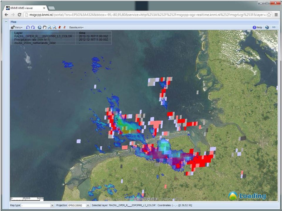
9 9

10 ADAGUC web service component - (Server, C++) Serves WMS on NetCDF4 and KNMI-HDF5 data files Multidim support! time, elevation, thresholds Visualize Data OGC Web Map Service: Field data: Models, radar, satellite incl. RGB Swath data: SCIAMACHY, ASCAT and point data Styling: contouring, shading, wind barbs, wind vectors; GetFeatureInfo Get info for a location as PNG, XML, GML or JSON Get Data OGC Web Coverage Service Subset, project and export data to several GIS formats Access of data through OpenDAP (remote netcdf) 10

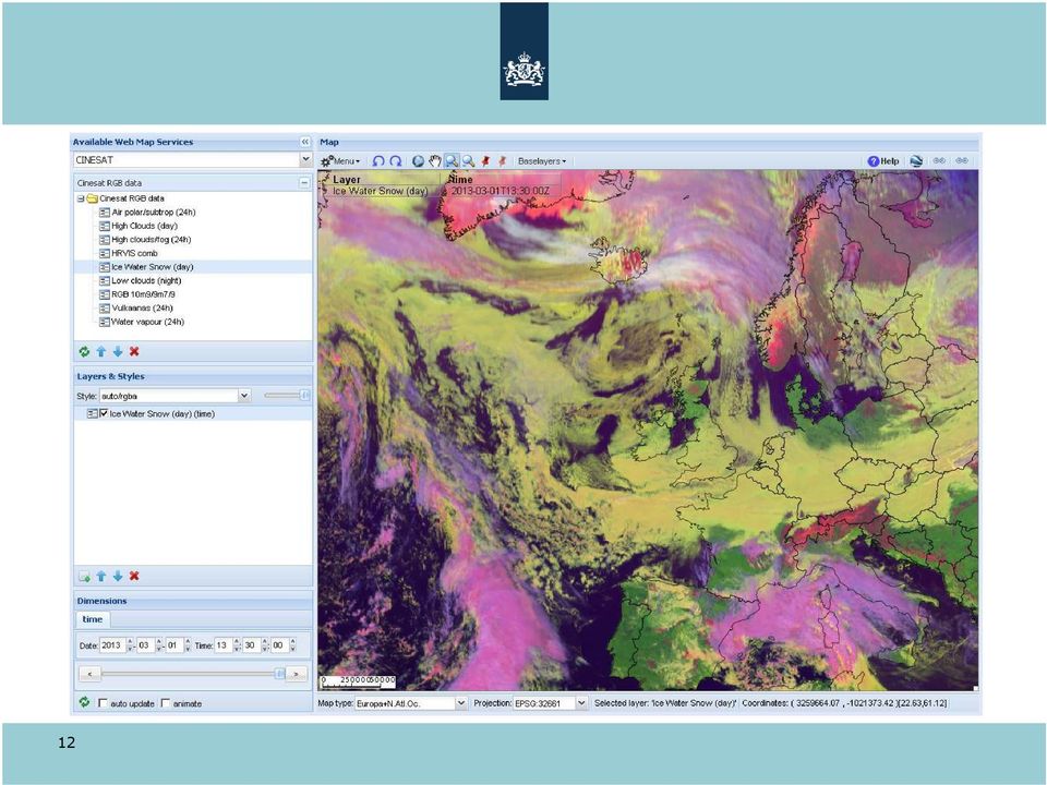
11 ADAGUC web viewer component - (Viewer) WMS portal based on ExtJS 3 (Working on ExtJS 4) Display legends, select styles, select dimensions Mapping component is plain JavaScript Enables download/manipulation from WCS services Portals main purpose: A simple way of combining layers from various WMS services. In space and time Visible via with demonstration data (including realtime rain radar products) 11

12 12
13 Internal applications: GLAMEPS Local area model ensemble, running at ECMWF with 54 members. GRIB data conversion to CF-NETCDF4 Map visualisation of individual member data, ensemble mean/standard deviation and probabilites of exceedance. Extra features: timeseries display plume graph s wind roses statistical bar charts Data for plume graphs etc is delivered by GetFeatureInfo in JSON or XML. Portal may prove to be be too spartan (or generic) 13

14 14
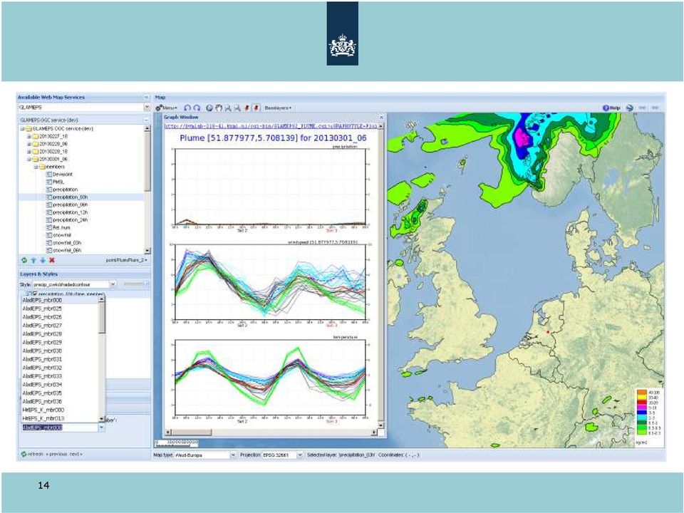
15 15

16 Internal applications: GPS project Make weather data available anywhere, Dutch maritime services for a start. Data: GRIB converted to CF-NETCDF Uses ADAGUC WMS as data resource Generate on-the-fly map products Raw data accessible via GetFeatureInfo in PHP, JavaScript and Python (GML, JSON) Custom timeseries based on JSON in PHP Single configuration for maps and data services 16
")
17 External applications: MSG CPP MSG Cloud Physical Properties Part of EUMETSAT CM-SAF Web portal for viewing of MSGCPP products Real-time data and archived data Basic ADAGUC portal Various methods of access : WMS, WCS, OpenDAP, FTP 17

18 External applications: Globemission Embedded ADAGUC viewer Controlled by hyperlinks Product selection Date selection Local ADAGUC server for WMS OMI and GOME2 NOx data Displays remote WMS services Offered by ncwms 18

19 External applications: ENES climate4impact portal ENES Portal Interface for the Climate Impact Communities Currently a working prototype: access and visualize CMIP5 data ~3Pb 19

20 External applications: EURO4M European Reanalysis and Observations for Monitoring Climate Indicator Bulletins with graphics and maps Maps are prepared in a mapeditor using WMS MediaWiki with embedded ADAGUC portal component accessing WMS services. 20

21 External applications: KNMI Data Centre Storage, catalogisation and publication of data and metadata All sorts of data Accent on metadata and searchability Preview of NetCDF4 (and HDF5) data with ADAGUC viewer component and web service as WMS CSW Catalog server (GeoNetworks) Connected to nationaalgeoregister 21
22 Data NMDC KNMI + Deltares + 1. De Bilt: KNMI Cloud condensed water path, product from Meteosat weather satellite 2. Delft: TNO/Deltares Dutch Continental Shelf grainsize map 3. Delft: TNO/Deltares MV100 digital depth/elevation model 4. Delft: Rijkswaterstaat operational continentel shelf model 1. De Bilt: KNMI Neerslagradar (alleen WMS ) 2. De Bilt: KNMI Cloud water content, product from Meteosat weather satellite 3. Delft: TNO/Deltares Dutch Continental Shelf grainsize map 2 4. Delft: TNO/Deltares MV100 digital depth/elevation model
23 Preview: Viewer 2.0 with ExtJS4 and WebMapJS 23
24 24 Simpler product selection
25 25 Simpler map and projection selection
26 WebMapJS component fully decoupled from ExtJS4 26
27 WebMapJS component API usage 27
28 28 Researchers can make their own viewers
29 29 Less buttons same functionality!
30 Plans: 30 ADAGUC components are widely applicable; development continues Update ADAGUC to WMS and support INSPIRE view services Stronger decoupling of mapping component and portal: light embeddable WMS viewer with API (JQuery based) Refactor portal: ExtJS4, multiple map windows, cleaner code WMC support in portal Increase usability for operational applications Workshop Application of ADAGUC service and portal : a 3 day hands-on workshop in June (mainly aimed at developers) Opensource repository available soon!
Open Source Visualisation with ADAGUC Web Map Services
 Open Source Visualisation with ADAGUC Web Map Services Maarten Plieger Ernst de Vreede John van de Vegte, Wim Som de Cerff, Raymond Sluiter, Ian van der Neut, Jan Willem Noteboom 1 ADAGUC project Cooperative
MSG Cloud Physical Properties retrieval and visualization
 MSG Cloud Physical Properties retrieval and visualization Jan Fokke Meirink Maarten Plieger John van de Vegte The MSG-CPP Project Goal: Provide an operational service for all products that are derived
DataTube: web services voor data
 DataTube: web services voor data Gerben de Boer Onno van de Akker Gerrit Hendriksen Deltares, Matroos Deltares, FEWS Deltares, NHI FEWS & Matroos: database > viewers VIEWER client 3 rd party viewer Matroos
EUMETSAT EO Portal. End User Image Access using OGC WMS/WCS services. EUM/OPS/VWG/10/0095 Issue <1> <14/01/2010> Slide: 1
 EUMETSAT EO Portal End User Image Access using OGC WMS/WCS services Slide: 1 Overview Introduction: status of data access and visualization EUMETSAT datasets Architecture Web Map Service implementation
VISUAL INSPECTION OF EO DATA AND PRODUCTS - OVERVIEW
 WMS services from the EUMETSAT real-time Image Gallery Uwe Voges (1), Michael Schick (2), Udo Einspanier (1) (1) con terra GmbH Martin-Luther-King-Weg 24, 48155, Münster, Germany EMail: (U.Voges U.Einspanier)@conterra.de
ADAGUC & PyTROLL. Maarten Plieger Ernst de Vreede. Application of polar orbiter products in weather forecasting Using open source tools and standards
 Application of polar orbiter products in weather forecasting Using open source tools and standards ADAGUC & PyTROLL Maarten Plieger Ernst de Vreede Royal Netherlands Meteorological Institute (KNMI) R&D
Model examples Store and provide Challenges WCS and OPeNDAP Recommendations. WCS versus OPeNDAP. Making model results available through the internet.
 Making model results available through the internet. Fedor Baart, Gerben de Boer, Wim de Haas, Gennadiy Donchyts, Marc Philippart, Maarten Plieger September 14, 2011 Introduction Fedor Baart PhD thesis:
NetCDF and HDF Data in ArcGIS
 2013 Esri International User Conference July 8 12, 2013 San Diego, California Technical Workshop NetCDF and HDF Data in ArcGIS Nawajish Noman Kevin Butler Esri UC2013. Technical Workshop. Outline NetCDF
The ORIENTGATE data platform
 Seminar on Proposed and Revised set of indicators June 4-5, 2014 - Belgrade (Serbia) The ORIENTGATE data platform WP2, Action 2.4 Alessandra Nuzzo, Sandro Fiore, Giovanni Aloisio Scientific Computing and
Open data. Noordzeedagen. Gerard van der Kolff
 Open data Noordzeedagen Gerard van der Kolff Data growth and -storage, what s new? Predicting the future is difficult... ...and mostly fails. The Digital Disruption has already happened Worlds largest
Jozef Matula. Visualisation Team Leader IBL Software Engineering. 13 th ECMWF MetOps Workshop, 31 th Oct - 4 th Nov 2011, Reading, United Kingdom
 Visual Weather web services Jozef Matula Visualisation Team Leader IBL Software Engineering Outline Visual Weather in a nutshell. Path from Visual Weather (as meteorological workstation) to Web Server
 Integrated Data Viewer (IDV) a visualization framework Yuan Ho Unidata Program Center Boulder, CO Presentation Outline Integrated Data Viewer (IDV) overview The IDV features IDV examples and customized
Data Visualization Using Web GIS Software
 Data Visualization Using Web GIS Software Tuomas Peltonen Radiation and Nuclear Safety Authority (STUK), Finland NKS NordDSS Workshop, Copenhagen, 1.-2.10.2009 RADIATION AND NUCLEAR SAFETY AUTHORITY Preface
PART 1. Representations of atmospheric phenomena
 PART 1 Representations of atmospheric phenomena Atmospheric data meet all of the criteria for big data : they are large (high volume), generated or captured frequently (high velocity), and represent a
CLOUD BASED N-DIMENSIONAL WEATHER FORECAST VISUALIZATION TOOL WITH IMAGE ANALYSIS CAPABILITIES
 CLOUD BASED N-DIMENSIONAL WEATHER FORECAST VISUALIZATION TOOL WITH IMAGE ANALYSIS CAPABILITIES M. Laka-Iñurrategi a, I. Alberdi a, K. Alonso b, M. Quartulli a a Vicomteh-IK4, Mikeletegi pasealekua 57,
The distribution of marine OpenData via distributed data networks and Web APIs. The example of ERDDAP, the message broker and data mediator from NOAA
 The distribution of marine OpenData via distributed data networks and Web APIs. The example of ERDDAP, the message broker and data mediator from NOAA Dr. Conor Delaney 9 April 2014 GeoMaritime, London
Norwegian Satellite Earth Observation Database for Marine and Polar Research http://normap.nersc.no USE CASES
 Norwegian Satellite Earth Observation Database for Marine and Polar Research http://normap.nersc.no USE CASES The NORMAP Project team has prepared this document to present functionality of the NORMAP portal.
What s new in Carmenta Server 4.2
 What s new in Carmenta Server 4.2 A complete solution for cost-effective visualisation and distribution of GIS data through web services Carmenta Server provides cost-effective technology for building
Vision. South Pacific GIS/RS Conference 2015 11/17/2015. Applying Geography Everywhere. Applying Geography Everywhere
 South Pacific GIS/RS Conference 2015 Applying Geography Everywhere Jithen (J) Singh Eagle Technology Group Ltd (Esri New Zealand) Suva, Fiji Vision Applying Geography Everywhere 1 GIS Is Evolving A Whole
Scientific Data Management and Dissemination
 Federal GIS Conference February 9 10, 2015 Washington, DC Scientific Data Management and Dissemination John Fry Solution Engineer, Esri [email protected] Agenda Background of Scientific Data Management through
Standardized data sharing through an open-source Spatial Data Infrastructure: the Afromaison project
 Standardized data sharing through an open-source Spatial Data Infrastructure: the Afromaison project Yaniss Guigoz - University of Geneva/GRID-Geneva 1 EcoARM2ERA and AFROMAISON Why Afromaison in this
How To Use Gis
 Welcome Understanding Purpose Creating Relationships You A Global Community of GIS Professionals Changing the World Together Applying Geography Everywhere Your WORK Showcasing Your Web Apps Vision Applying
Web-based spatio-temporal visualization and analysis of the Siberian Earth System Science Cluster (SIB-ESS-C)
") Web-based spatio-temporal visualization and analysis of the Siberian Earth System Science Cluster (SIB-ESS-C) Roman Gerlach Supervisor: Prof. C. Schmullius (Dept. of Geography, Friedrich-Schiller-University
Web-based spatio-temporal visualization and analysis of the Siberian Earth System Science Cluster (SIB-ESS-C) Roman Gerlach Supervisor: Prof. C. Schmullius (Dept. of Geography, Friedrich-Schiller-University
INSPIRE Dashboard. Technical scenario
 INSPIRE Dashboard Technical scenario Technical scenarios #1 : GeoNetwork catalogue (include CSW harvester) + custom dashboard #2 : SOLR + Banana dashboard + CSW harvester #3 : EU GeoPortal +? #4 :? + EEA
smespire - Exercises for the Hands-on Training on INSPIRE Network Services April 2014 Jacxsens Paul SADL KU Leuven
 smespire - Exercises for the Hands-on Training on INSPIRE Network Services April 2014 Jacxsens Paul SADL KU Leuven These exercises aim at people who already have some basic knowledge of INSPIRE Network
GOSIC NEXRAD NIDIS NOMADS
 NOAA National Climatic Data Center GOSIC NEXRAD NIDIS NOMADS Christina Lief NOAA/NESDIS/NCDC GOSIC Program Manager NOAA/NESDIS/NCDC Asheville, NC 28801 GEOSS AIP Phase 2 Workshop September 25-26, 2008
Metadata for Data Discovery: The NERC Data Catalogue Service. Steve Donegan
 Metadata for Data Discovery: The NERC Data Catalogue Service Steve Donegan Introduction NERC, Science and Data Centres NERC Discovery Metadata The Data Catalogue Service NERC Data Services Case study:
Design Requirements for an AJAX and Web-Service Based Generic Internet GIS Client
 11th AGILE International Conference on Geographic Information Science 2008 Page 1 of 6 Design Requirements for an AJAX and Web-Service Based Generic Internet GIS Client Edward Nash 1, Peter Korduan 1,
MyOcean Copernicus Marine Service Architecture and data access Experience
 MyOcean Copernicus Marine Service Architecture and data access Experience Sophie Besnard CLS, Toulouse, France February 2015 MyOcean Story MyOcean Challenge & Success MyOcean Service MyOcean System MyOcean
HELCOM Data and Map Service. User Manual
 HELCOM Data and Map Service User Manual Version 2.2 - February 2015 1 Table of contents 1. General Information... 3 1.1 Background... 3 1.2 Technical requirements... 3 1.3 Contact... 3 2. Accessing HELCOM
Oklahoma s Open Source Spatial Data Clearinghouse: OKMaps
 Oklahoma s Open Source Spatial Data Clearinghouse: OKMaps Presented by: Mike Sharp State Geographic Information Coordinator Oklahoma Office of Geographic Information MAGIC 2014 Symposium April 28-May1,
DISMAR implementing an OpenGIS compliant Marine Information Management System
 DISMAR implementing an OpenGIS compliant Marine Information Management System Éamonn Ó T uama, Coastal & Marine Resources Centre, ERI, University College Cork. DISMAR DISMAR (Data Integration System for
Overview of Data Visualization Tools. (Submitted by the Secretariat) Summary and Purpose of Document
 Summary and Purpose of Document") WORLD METEOROLOGICAL ORGANIZATION COMMISSION FOR BASIC SYSTEMS OPEN PROGRAMME AREA GROUP ON INTEGRATED OBSERVING SYSTEMS EXPERT TEAM ON SATELLITE UTILIZATION AND PRODUCTS SCOPE-Nowcasting Ad-hoc Steering
WORLD METEOROLOGICAL ORGANIZATION COMMISSION FOR BASIC SYSTEMS OPEN PROGRAMME AREA GROUP ON INTEGRATED OBSERVING SYSTEMS EXPERT TEAM ON SATELLITE UTILIZATION AND PRODUCTS SCOPE-Nowcasting Ad-hoc Steering
The Arctic Observing Network and its Data Management Challenges Florence Fetterer (NSIDC/CIRES/CU), James A. Moore (NCAR/EOL), and the CADIS team
, James A. Moore (NCAR/EOL), and the CADIS team") The Arctic Observing Network and its Data Management Challenges Florence Fetterer (NSIDC/CIRES/CU), James A. Moore (NCAR/EOL), and the CADIS team Photo courtesy Andrew Mahoney NSF Vision What is AON? a
The Arctic Observing Network and its Data Management Challenges Florence Fetterer (NSIDC/CIRES/CU), James A. Moore (NCAR/EOL), and the CADIS team Photo courtesy Andrew Mahoney NSF Vision What is AON? a
From Geoportal to Spatial Data Service Platform. Jani Kylmäaho National Land Survey of Finland Development Centre
 From Geoportal to Spatial Data Service Platform Jani Kylmäaho National Land Survey of Finland Development Centre 29.6.2012 Introduction National Land Survey of Finland - 1900 employees Development Centre
Data and data product visualization in EMODNET Chemistry
 Data and data product visualization in EMODNET Chemistry Alexander Barth (1), Giorgio Santinelli (2), Gerrit Hendriksen (2), Jean-Marie Beckers (1) (1) University of Liège (Belgium), (2) Deltares (Netherlands)
Satellite Products and Dissemination: Visualization and Data Access
 Satellite Products and Dissemination: Visualization and Data Access Gregory Leptoukh GES DISC, NASA GSFC Dana Ostrenga GES DISC, NASA GSFC Introduction The Goddard Earth Sciences Data and Information Services
INTEROPERABLE IMAGE DATA ACCESS THROUGH ARCGIS SERVER
 INTEROPERABLE IMAGE DATA ACCESS THROUGH ARCGIS SERVER Qian Liu Environmental Systems Research Institute 380 New York Street Redlands, CA92373, U.S.A - [email protected] KEY WORDS: OGC, Standard, Interoperability,
Analysis of Climatic and Environmental Changes Using CLEARS Web-GIS Information-Computational System: Siberia Case Study
 Analysis of Climatic and Environmental Changes Using CLEARS Web-GIS Information-Computational System: Siberia Case Study A G Titov 1,2, E P Gordov 1,2, I G Okladnikov 1,2, T M Shulgina 1 1 Institute of
DISMAR: Data Integration System for Marine Pollution and Water Quality
 DISMAR: Data Integration System for Marine Pollution and Water Quality T. Hamre a,, S. Sandven a, É. Ó Tuama b a Nansen Environmental and Remote Sensing Center, Thormøhlensgate 47, N-5006 Bergen, Norway
CURSO Inspire INSPIRE. SPEAKER: Pablo Echamendi Lorente. JEUDI 23/ THURSDAY 23 rd W S V : G E O S P A T I A L D A T A A C C E S S
 CURSO Inspire JEUDI 23/ THURSDAY 23 rd SPEAKER: Pablo Echamendi Lorente WS 5 SCHEDULE WMS OVERVIEW ACTIONS OGC SPECIFICATIONS OTHER SERVICES OVERVIEW proposal: Member States shall establish and operate
Version 3.0, April 16, 2012, updated for ArcGIS 10.0 Produced by the Geographic Information Network of Alaska http://www.gina.alaska.
 Using the AlaskaMapped Web Services in ESRI ArcGIS Version 3.0, April 16, 2012, updated for ArcGIS 10.0 Produced by the Geographic Information Network of Alaska http://www.gina.alaska.edu AlaskaMapped
J9.6 GIS TOOLS FOR VISUALIZATION AND ANALYSIS OF NEXRAD RADAR (WSR-88D) ARCHIVED DATA AT THE NATIONAL CLIMATIC DATA CENTER
 ARCHIVED DATA AT THE NATIONAL CLIMATIC DATA CENTER") J9.6 GIS TOOLS FOR VISUALIZATION AND ANALYSIS OF RADAR (WSR-88D) ARCHIVED DATA AT THE NATIONAL CLIMATIC DATA CENTER Steve Ansari * STG Incorporated, Asheville, North Carolina Stephen Del Greco NOAA National
J9.6 GIS TOOLS FOR VISUALIZATION AND ANALYSIS OF RADAR (WSR-88D) ARCHIVED DATA AT THE NATIONAL CLIMATIC DATA CENTER Steve Ansari * STG Incorporated, Asheville, North Carolina Stephen Del Greco NOAA National
Webservices Technological Evolutions. Peter Bogaert University of Ghent (Belgium) E Governement Academy 8 Geoservices 15 februari 2006 Kortrijk.
 E Governement Academy 8 Geoservices 15 februari 2006 Kortrijk.") Webservices Technological Evolutions Peter Bogaert University of Ghent (Belgium) Van Mainframe naar een gedistribueerd GIS Geographic Informationsystems From mainframe to distributed systems by means of
Webservices Technological Evolutions Peter Bogaert University of Ghent (Belgium) Van Mainframe naar een gedistribueerd GIS Geographic Informationsystems From mainframe to distributed systems by means of
Publishing geospatial data to the web using the EEA infrastructure
 Publishing geospatial data to the web using the EEA infrastructure *Note: Map Services should be published using the EEA Map Services Tick Sheet for guidance. Contact Sebastien Petit ([email protected])
A Web Service based U.S. Cropland Visualization, Dissemination and Querying System
 A Web Service based U.S. Cropland Visualization, Dissemination and Querying System Rick Mueller, Zhengwei Yang, and Dave Johnson USDA/National Agricultural Statistics Service Weiguo Han and Liping Di GMU/Center
GIS AS A DECISION SUPPORT FOR SUPPLY CHAIN MANAGEMENT
 Paper Reference No.: PN-253 GIS AS A DECISION SUPPORT FOR SUPPLY CHAIN MANAGEMENT Sanjay Kumar 1 and Suneeta Agrawal 2 1. M. Tech. (GIS & Remote Sensing); GIS Cell; MNNIT, Allahabad, India (E-mail: [email protected])
Neues vom QGIS Server und QGIS-Webclient
 FOSSGIS 2012 Neues vom QGIS Server und QGIS-Webclient Pirmin Kalberer Sourcepole AG, Pfäffikon SZ www.sourcepole.ch Über Sourcepole > QGIS > Core dev. & Project Steering Commitee > Printing, QGIS Server,
Analysis of the Free GIS Software Applications in respect to INSPIRE services and OGC standards
 Analysis of the Free GIS Software Applications in respect to INSPIRE services and OGC standards Authors: Francesco D'Alesio Peter Hopfgartner Paolo Viskanic June 2011 Executive Summary This document analyses
2009 CAP Grant Kickoff USGS, Reston, VA May 21, 2009
 Leveraging GOS Map and Data Services for Search and Rescue Operations using NASA WorldWind Open Source 3D Visualization Platform Nadine Alameh, Ph.D. MobiLaps LLC 2009 CAP Grant Kickoff USGS, Reston, VA
Data Management in support of Climate Services @ MeteoSwiss
 Eidgenössisches Departement des Innern EDI Bundesamt für Meteorologie und Klimatologie MeteoSchweiz Data Management in support of Climate Services @ MeteoSwiss Estelle Grueter, Heike Kunz (MeteoSwiss)
What's new in gvsig Desktop 2.0
 What's new in gvsig Desktop 2.0 What are the novelties? 2.0 1.12 Migrating and building... Some examples... Please pardon our appearance during construction Pie and bar chart legends Table in layout 1.12
Final Report - HydrometDB Belize s Climatic Database Management System. Executive Summary
 Executive Summary Belize s HydrometDB is a Climatic Database Management System (CDMS) that allows easy integration of multiple sources of automatic and manual stations, data quality control procedures,
Título/Title: Mejoras y avances conseguidos en el Atlas SPINCAM para el año 2014. WP3 Datos y sistemas de información
 Título/Title: Mejoras y avances conseguidos en el Atlas SPINCAM para el año 2014 Actividad en el plan de trabajo WP3 Datos y sistemas de información Autor: Fecha: Reunión: PAIS: Ecuador INSTITUCIÓN: CPPS
Sextant. Spatial Data Infrastructure for Marine Environment. C. Satra Le Bris, E. Quimbert, M. Treguer
 Sextant On-Line information system for marine geographical information E. Quimbert, M. Bellouis, F. Lecuy, M. Treguer Centre de Bretagne BP 70, Plouzané 29280 France E-mail: [email protected] Sextant
The THREDDS Data Repository: for Long Term Data Storage and Access
 8B.7 The THREDDS Data Repository: for Long Term Data Storage and Access Anne Wilson, Thomas Baltzer, John Caron Unidata Program Center, UCAR, Boulder, CO 1 INTRODUCTION In order to better manage ever increasing
Scott Moore, Esri April 4, 2016 2016 Intermountain, Great Falls, MT
 Create Great Web Apps No Coding Required Scott Moore, Esri April 4, 2016 2016 Intermountain, Great Falls, MT Agenda Product overview Web AppBuilder for ArcGIS tour What s New November 2015 ArcGIS Online
DATA ACCESS AT EUMETSAT
 1 EUM/OPS/VWG/15/793789 v1a DATA ACCESS AT EUMETSAT Copernicus Climate Data Store Workshop ECMWF 3-6 March 2015 Harald Rothfuss Overview of Presentation 1. Introduction to EUMETSAT 2. EUMETSAT Data Access
Primary author: Kaspar, Frank (DWD - Deutscher Wetterdienst), [email protected]
, Frank.Kaspar@dwd.de") Primary author: Kaspar, Frank (DWD - Deutscher Wetterdienst), [email protected] Co-authors: Johannes Behrendt (DWD - Deutscher Wetterdienst), Klaus-Jürgen Schreiber (DWD - Deutscher Wetterdienst) Abstract
Primary author: Kaspar, Frank (DWD - Deutscher Wetterdienst), [email protected] Co-authors: Johannes Behrendt (DWD - Deutscher Wetterdienst), Klaus-Jürgen Schreiber (DWD - Deutscher Wetterdienst) Abstract
MSDI: Workflows, Software and Related Data Standards
 MSDI: Workflows, Software and Related Data Standards By Andy Hoggarth October 2009 Introduction Leveraging SDI principles for hydrographic operational efficiency French INFRAGEOS example (SHOM - Service
WCS 2.0 Extension for netcdf-cf; CSW and THREDDS Interoperability
 GEOSS Workshop XLIII: Sharing Climate Information & Knowledge NCAR Center Green, Boulder Colorado, 23 Sept 2011, 8:00am 5:30pm WCS 2.0 Extension for netcdf-cf; CSW and THREDDS Interoperability S.Nativi
GeoNetwork User Manual
 GeoNetwork User Manual Release 2.10.4-0 GeoNetwork July 06, 2015 Contents 1 Preface 3 1.1 About this Project..................................... 3 1.2 License Information....................................
Interoperable Solutions in Web-based Mapping
 ISPRS SIPT IGU UCI CIG ACSG Table of contents Table des matières Authors index Index des auteurs Search Recherches Exit Sortir Interoperable Solutions in Web-based Mapping Marta Wojnarowska and Bridget
OPEN STANDARD WEB SERVICES FOR VISUALISATION OF TIME SERIES DATA OF FLOOD MODELS
 OPEN STANDARD WEB SERVICES FOR VISUALISATION OF TIME SERIES DATA OF FLOOD MODELS Barend Köbben FRMRC RPA 7 Workshop visualisations and flow simulations as flood risk communication tools
Data management and archiving
 Data management and archiving for COP / GOP / D_PHASE 4 th COPS Workshop 25./26.09. 2006 Stuttgart Claudia Wunram Hannes Thiemann 25.-26.09.06 / 1 Data archive Long term data archive for COPS, GOP and
Institute of Computational Modeling SB RAS
 Institute of Computational Modeling SB RAS ORGANIZATION OF ACCESS TO OBSERVATIONAL DATA USING WEB SERVICES FOR MONITORING SYSTEMS THE STATE OF THE ENVIRONMENT Kadochnikov Aleksey A. Russia, Krasnoyarsk
Figure 2: System Flow Diagram for Workflow Management
 5. WORKFLOW MANAGEMENT The developed system EASKB uses the open source content management system called Drupal ([2]). A Content Management System - CMS is a tool that enables many user friendly features
Portal Version 1 - User Manual
 Portal Version 1 - User Manual V1.0 March 2016 Portal Version 1 User Manual V1.0 07. March 2016 Table of Contents 1 Introduction... 4 1.1 Purpose of the Document... 4 1.2 Reference Documents... 4 1.3 Terminology...
WP 3. Elaboration database Architecture Features (Software Architecture Document)
") Architecture Features (Software Architecture Document) o Best in class solution, using EC recommendations for IT in this field o Implementation based on free open source o Based on OGC standards, high
Architecture Features (Software Architecture Document) o Best in class solution, using EC recommendations for IT in this field o Implementation based on free open source o Based on OGC standards, high
CentropeSTATISTICS a Tool for Cross-Border Data Presentation Manfred Schrenk, Clemens Beyer, Norbert Ströbinger
 Manfred Schrenk, Clemens Beyer, Norbert Ströbinger (Dipl.-Ing. Manfred Schrenk, Multimediaplan.at, 2320 Schwechat, Austria, [email protected]) (Dipl.-Ing. Clemens Beyer, CORP Competence Center
CDI/THREDDS Interoperability: the SeaDataNet developments. P. Mazzetti 1,2, S. Nativi 1,2, 1. CNR-IMAA; 2. PIN-UNIFI
 CDI/THREDDS Interoperability: the SeaDataNet developments P. Mazzetti 1,2, S. Nativi 1,2, 1. CNR-IMAA; 2. PIN-UNIFI Outline Interoperability Issues in SeaDataNet A broker solution for CDI/THREDDS interoperability
Leveraging Cloud-Based Mapping Solutions
 Leveraging Cloud-Based Mapping Solutions GeoAlberta October 28, 2014 Laura Kerssens Safe Software Agenda To the Cloud Using Basic Services Cloud Applications Web Services Cloud-Hosted Databases Real-time
PDOK Kaart, the Dutch Mapping API
 PDOK Kaart, the Dutch Mapping API Haico van der Vegt*, Leo van der Sluijs* * Cadastre, Land Registry and Mapping Agency of the Netherlands Abstract. PDOK (public services on the map) is a partnership of
Baudouin Raoult, Iryna Rozum, Dick Dee
 ECMWF contribution to the EU funded CHARME Project: A Significant Event Viewer tool Matthew Manoussakis Baudouin Raoult, Iryna Rozum, Dick Dee 5th Workshop on the use of GIS/OGC standards in meteorology
ArcGIS Platform. An Integrated System. Portal
 Platform An Integrated System Portal An Integrated Web GIS Platform Knowledge Workers Executive Access Public Engagement Work Anywhere Enterprise Integration Providing Mapping, Analysis, Data Management,
Web and Mobile GIS Applications Development
 Web and Mobile GIS Applications Development Presented by : Aamir Ali Manager Section Head (GIS Software Customization) Pakistan Space and Upper Atmosphere Research Commission (SUPARCO) Geographical Information
Web Map Context Service for Adaptive Geospatial Data Visualization
 Web Map Context Service for Adaptive Geospatial Data Visualization Miloš Bogdanović, Danilo Vulović, Leonid Stoimenov INTRODUCTION Faculty of Electronic Engineering, University of Niš, Serbia {milos.bogdanovic,
13.2 THE INTEGRATED DATA VIEWER A WEB-ENABLED APPLICATION FOR SCIENTIFIC ANALYSIS AND VISUALIZATION
 13.2 THE INTEGRATED DATA VIEWER A WEB-ENABLED APPLICATION FOR SCIENTIFIC ANALYSIS AND VISUALIZATION Don Murray*, Jeff McWhirter, Stuart Wier, Steve Emmerson Unidata Program Center, Boulder, Colorado 1.
GeoNetwork, The Open Source Solution for the interoperable management of geospatial metadata
 GeoNetwork, The Open Source Solution for the interoperable management of geospatial metadata Ing. Emanuele Tajariol, GeoSolutions Ing. Simone Giannecchini, GeoSolutions GeoSolutions GeoSolutions GeoNetwork
DKAN. Data Warehousing, Visualization, and Mapping
 DKAN Data Warehousing, Visualization, and Mapping Acknowledgements We d like to acknowledge the NuCivic team, led by Andrew Hoppin, which has done amazing work creating open source tools to make data available
HYCOM Meeting. Tallahassee, FL
 HYCOM Data Service An overview of the current status and new developments in Data management, software and hardware Ashwanth Srinivasan & Jon Callahan COAPS FSU & PMEL HYCOM Meeting Nov 7-9, 7 2006 Tallahassee,
The ORIENTGATE data platform
 Research Papers Issue RP0195 December 2013 The ORIENTGATE data platform SCO Scientific Computing and Operations Division By Alessandra Nuzzo University of Salento and Scientific Computing and Operations
SRS BIO OPTICAL WORKFLOW
 SRS BIO OPTICAL WORKFLOW Version 2.0 22 nd March 2013 Data Workflows emii, the data management facility for IMOS, has developed workflows for each IMOS sub facility to describe the flow of IMOS data from
How To Use The Alabama Data Portal
 113 The Alabama Metadata Portal: http://portal.gsa.state.al.us By Philip T. Patterson Geological Survey of Alabama 420 Hackberry Lane P.O. Box 869999 Tuscaloosa, AL 35468-6999 Telephone: (205) 247-3611
Team Members: Christopher Copper Philip Eittreim Jeremiah Jekich Andrew Reisdorph. Client: Brian Krzys
 Team Members: Christopher Copper Philip Eittreim Jeremiah Jekich Andrew Reisdorph Client: Brian Krzys June 17, 2014 Introduction Newmont Mining is a resource extraction company with a research and development
SuperGIS Server 3.2 Standard Edition Specification
 SuperGIS Server 3.2 Standard Edition Specification 20140826 Specification 1. All of the services support SOAP (Simple Object Access Protocol). 2. Use map file created by SuperGIS Desktop as map services
HydroDesktop Overview
 HydroDesktop Overview 1. Initial Objectives HydroDesktop (formerly referred to as HIS Desktop) is a new component of the HIS project intended to address the problem of how to obtain, organize and manage
100% NO CODING NO DEVELOPING IMMEDIATE BUSINESS -25% -70% UNLIMITED SCALABILITY DEVELOPMENT TIME SOFTWARE STABILITY
 100% UNLIMITED SCALABILITY TOTAL COST OF OWNERSHIP -25% +50% EFFICENCY INCREASE -70% +65% DEVELOPMENT TIME SOFTWARE STABILITY NO CODING NO DEVELOPING IMMEDIATE BUSINESS FlexyGo Rapid Application Builder