Vision. South Pacific GIS/RS Conference /17/2015. Applying Geography Everywhere. Applying Geography Everywhere
|
|
|
- Lucas Casey
- 8 years ago
- Views:
Transcription
1 South Pacific GIS/RS Conference 2015 Applying Geography Everywhere Jithen (J) Singh Eagle Technology Group Ltd (Esri New Zealand) Suva, Fiji Vision Applying Geography Everywhere 1
 Suva, Fiji Vision Applying")
2 GIS Is Evolving A Whole New Pattern Is Emerging Collaborative 3D Analytics Visualization Apps Applications Implementation Open Configurable Agile Easier Ready to Use Crowdsourcing Sensors Scientific Data Field Survey Real-Time Remote Sensing UAVs Content GPS Social Media Virtualization Technology Big Data Smart Devices Consumerization IoT Cloud Integrating Many Innovations Web GIS Empowers GIS Professionals Expanding Your Impact Across the Organization Knowledge Workers Executives Casual Users GIS Professionals Open Data Community Providing Everyone the Geographic Advantage 2

3 ArcGIS An Integrated Web GIS Platform Desktop Web Device Identity Security Portal Providing Mapping, Analysis, Data Management, and Collaboration Server Online Content and Services Available on the Open Web and On-Premises Real-Time Security Interoperability 3D Quality Usability Performance Administration Identity Mapping Editing Our WORK Location Analytics Standards Creating Useful Technology and Supporting Our Users 3

4 Desktop Applying Geography Everywhere Desktop Professional GIS Web GIS Desktop 4

5 Desktop Professional GIS ArcMap ArcGIS Pro Desktop Professional GIS ArcMap continues to be a current and important product for us. ArcMap ArcGIS Pro ArcGIS Pro is a part of Desktop Desktop ArcMap and ArcGIS Pro - Separate install - Imports MXDs, SXDs, and 3DDs - Models and Python Scripts Files DBMS Server Cloud Basic, Standard, and Advanced Levels 5

6 Desktop Professional GIS Coming ArcMap Desktop ArcGIS Pro Apps Web GIS (Online/Portal) New and Improved Geoprocessing Space-Time Modeling Image Processing LAS Tools Customization of Pro More Analytics & 3D Drone Support Mobile Map Packages Better Metadata Concurrent Pro Licensing Providing Mapping, Visualization, Editing, and Analysis... Simplifying and Improving Web GIS Applying Geography Everywhere 6

7 Portals Transforming how we work Smart Mapping Data-driven web cartography and data exploration 7

8 Analysis Cloud-based analysis for everyone Open Data Integrated Workflows to Share Geospatial and Tabular Data opendata.arcgis.com 8

9 A World of Apps Applying Geography Everywhere A World of Apps We Build Apps 9

10 Apps Making ArcGIS Available Everywhere Navigator Field Workforce ArcGIS for AutoCAD Office Maps for Office Public Open Data Story Maps Explorer ArcGIS Earth Collector Survey123 Mobile (Connected & Disconnected) Configurable Solutions That Work Together Dashboard Photo Survey Crowdsourcing Easy, Focused, and Ready-to-Use App Builders Enabling App Creation Web App Templates Web AppBuilder AppStudio Widgets (Apple, Android, Windows, Linux) HTML5/JavaScript Native Apps Providing Easy, Configurable, and Extensible Tools Design Once, Run Everywhere... 10
 HTML5/JavaScript Native Apps Providing Easy, Configurable, and Extensible Tools Design Once, Run")
11 Open ArcGIS Platform Applying Geography Everywhere Open Platform Ensuring Data and System Interoperability Standards GML WCS KML WMS SQL CSW WFS OPENDAP SOAP WMTS IFC SLD NetCDF GeoPackage WPS LAS REST Industry Formats WaterML Web Scene (I3S) Imagery OLEDB DXF Hadoop CityGML DBMS COLLADA AIXM DWG DGN OneGeology INSPIRE FileGDB Shapefiles Extensible Architecture Open Software Interoperability Open-Source Integration Embeddable Open APIs Open-Source Libraries Open Data... Integrated Into Thousands of Systems 11

12 Amplify Your GIS Imagine the possibilities Portal South Pacific GIS/RS Conference 2015 Questions & Discussion? Suva, Fiji 12

13 HAIRY BERRIES AND FREAKEN FLIES! APPLYING GEOGRAPHY EVERYWHERE SOUTH PACIFIC GIS/RS CONFERENCE

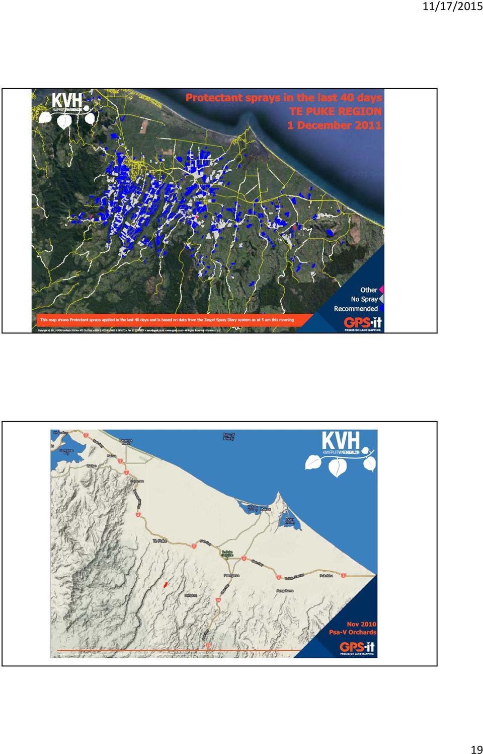
14 2905 Kiwifruit Orchards throughout NZ canopy hectares Average Size = 3.87 ha 14

15 Basically One Big Orchard 15

16

17 11/17/

18 18

19 19
20
21 21
22 22
23 23
24 24
25 25
26 26
27 27
How To Use Gis
 Welcome Understanding Purpose Creating Relationships You A Global Community of GIS Professionals Changing the World Together Applying Geography Everywhere Your WORK Showcasing Your Web Apps Vision Applying
Welcome Esri Classified User Symposium
 Welcome Esri Classified User Symposium Understanding Purpose Creating Relationships Special Achievement in GIS (SAG) Award Applying Geography Everywhere Your WORK Cartography Aeronautical Topographic Nautical
ArcGIS Platform. An Integrated System. Portal
 Platform An Integrated System Portal An Integrated Web GIS Platform Knowledge Workers Executive Access Public Engagement Work Anywhere Enterprise Integration Providing Mapping, Analysis, Data Management,
MSDI Open Forum Building a Maritime Spatial Data Infrastructure Are the principles at odds with strategies for delivery?
 MSDI Open Forum Building a Maritime Spatial Data Infrastructure Are the principles at odds with strategies for delivery? Rafael Ponce Global Maritime Business Development Manager, Esri Inc. Tuesday, March
ArcGIS. Server. A Complete and Integrated Server GIS
 ArcGIS Server A Complete and Integrated Server GIS ArcGIS Server A Complete and Integrated Server GIS ArcGIS Server enables you to distribute maps, models, and tools to others within your organization
ArcGIS Pro. James Tedrick, Esri
 ArcGIS Pro James Tedrick, Esri What you already know Why ArcGIS PRO? Vision The next generation ArcGIS desktop application for the GIS community who need a clean and comprehensive user experience which
Intro to Web App Builder. Mark Scott, Solutions Engineer, Esri County Government Team mscott@esri.com
 Intro to Web App Builder Mark Scott, Solutions Engineer, Esri County Government Team mscott@esri.com The ArcGIS Platform enables Web GIS Enabling GIS Everywhere Desktop Web Device Simple Integrated Open
Essential Mapping Apps
 Essential Mapping Apps 74% of adults use their smartphone to look at maps or other information based on their current location (of the 58% that own a smart phone) Pew Research Center Maps for Directions
Web and Mobile GIS Applications Development
 Web and Mobile GIS Applications Development Presented by : Aamir Ali Manager Section Head (GIS Software Customization) Pakistan Space and Upper Atmosphere Research Commission (SUPARCO) Geographical Information
SuperGIS Server 3.2 Standard Edition Specification
 SuperGIS Server 3.2 Standard Edition Specification 20140826 Specification 1. All of the services support SOAP (Simple Object Access Protocol). 2. Use map file created by SuperGIS Desktop as map services
Introduction to Web AppBuilder for ArcGIS: JavaScript Apps Made Easy
 Introduction to Web AppBuilder for ArcGIS: JavaScript Apps Made Easy OKSCAUG Pamela Kersh September 22, 2015 The ArcGIS Platform enables Web GIS Enabling GIS Everywhere Desktop Web Device Simple Integrated
Network Analysis with ArcGIS Online
 Federal GIS Conference February 9 10, 2015 Washington, DC Network Analysis with ArcGIS Online Matt Kennedy Topics Online versus on-premise network analysis services How to access online services How to
Petroleum Web Applications to Support your Business. David Jacob & Vanessa Ramirez Esri Natural Resources Team
 Petroleum Web Applications to Support your Business David Jacob & Vanessa Ramirez Esri Natural Resources Team Agenda Petroleum Web Apps to Support your Business The ArcGIS Location Platform Introduction
Editing Strategies for Enterprise Geodatabase
 Federal GIS Conference February 9 10, 2015 Washington, DC Editing Strategies for Enterprise Geodatabase Ty Fabling Esri Solution Engineer A Complete Platform Enabling GIS Everywhere Desktop Web Device
Enterprise GIS Solutions to GIS Data Dissemination
 Enterprise GIS Solutions to GIS Data Dissemination ESRI International User Conference July 13 17, 2009 Wendy M. Turner Senior GIS Engineer & Program Manager Freedom Consulting Group, LLC Building the Enterprise
MAY 18, 2015 ARCGIS 10.3.1 FOR SERVER FUNCTIONALITY MATRIX
 MAY 18, 2015 ARCGIS 10.3.1 FOR SERVER FUNCTIONALITY MATRIX Copyright 2015 Esri All rights reserved. Printed in the United States of America. The information contained in this document is the exclusive
Raise of hands on anyone whos used the Flex or Silverlight Application Builders?
 Raise of hands on whos used the Beta for Web Application Builder? Raise of hands on anyone whos done any web development? Raise of hands on anyone whos used the Flex or Silverlight Application Builders?
ArcGIS Web Mapping. Sam Berg, esri sberg@esri.com
 ArcGIS Web Mapping Sam Berg, esri sberg@esri.com Agenda ArcGIS and WebMaps The APIs ArcGIS for Flex Viewer ArcGIS for Silverlight Builder ArcGIS for Sharepoint ArcGIS Application Templates ArcGIS Runtime
An Esri White Paper June 2011 ArcGIS for INSPIRE
 An Esri White Paper June 2011 ArcGIS for INSPIRE Esri, 380 New York St., Redlands, CA 92373-8100 USA TEL 909-793-2853 FAX 909-793-5953 E-MAIL info@esri.com WEB esri.com Copyright 2011 Esri All rights reserved.
THE FAST TRACK TO BUILDING SMART COMMUNITIES BENEFITING FROM THE SMALL MUNICIPAL AND COUNTY GOVERNMENT ENTERPRISE AGREEMENT
 THE FAST TRACK TO BUILDING SMART COMMUNITIES BENEFITING FROM THE SMALL MUNICIPAL AND COUNTY GOVERNMENT ENTERPRISE AGREEMENT GIS: A Foundation for Building Smart Communities A Better Way to Build a GIS
Mobile GIS Guide. About The Author. Getting your mobile GIS project off the ground
 About The Author Matt Sheehan is a mobile GIS pioneer. He and his staff at WebMapSolutions have been providing clients with mobile GIS solutions since the earliest days of smartphones and tablets. We live
Making Your Mobile Workforce More Efficient
 ArcGIS for Mobile Making Your Mobile Workforce More Efficient What Is Mobile GIS? Mobile geographic information system (GIS) technology extends GIS beyond the office and allows organizations to make accurate,
Esri GIS Mobile Solutions. John Sharrard jsharrard@esri.com
 Esri GIS Mobile Solutions John Sharrard jsharrard@esri.com If I had asked people what they wanted, they would have said faster horses. Henry Ford Trend: Increase demand for location services Pew Research
Data Integration for ArcGIS Users Data Interoperability. Charmel Menzel, ESRI Don Murray, Safe Software
 Data Integration for ArcGIS Users Data Interoperability Charmel Menzel, ESRI Don Murray, Safe Software Product overview Extension to ArcGIS (optional) Jointly developed with Safe Software Based on Feature
Lecture 8. Online GIS
 Lecture 8 Online GIS Lecture 8: Outline I. Online GIS 1. Google Earth 2. MSN Live Maps II. Open Source GIS III. ArcGIS Server and the ESRI suite of online software utility options IV. Advanced Data Mining
Portal for ArcGIS. Satish Sankaran Robert Kircher
 Portal for ArcGIS Satish Sankaran Robert Kircher ArcGIS A Complete GIS Data Management Planning & Analysis Field Mobility Operational Awareness Constituent Engagement End to End Integration Collect, Organize,
Note: Hands On workshops are Bring Your Own Laptop (BYOL), unless otherwise noted. Some workshops are Bring Your Own Mobile Device(BYOD).
, unless otherwise noted. Some workshops are Bring Your Own Mobile Device(BYOD).") 2015 MN GIS/LIS Consortium Pre Conference Workshops The Minnesota GIS/LIS Consortium is pleased to offer a diverse list of workshops on Wednesday, October 7th, 2015 at the DECC, Duluth, Minnesota Charting
2015 MN GIS/LIS Consortium Pre Conference Workshops The Minnesota GIS/LIS Consortium is pleased to offer a diverse list of workshops on Wednesday, October 7th, 2015 at the DECC, Duluth, Minnesota Charting
Data Fusion Centers. Transforming Public Safety Information into Actionable Knowledge
 Data Fusion Centers Transforming Public Safety Information into Actionable Knowledge Defining Geospatial Data Fusion Homeland security relies on fusion the ability to capture and analyze data from multiple
Scott Moore, Esri April 4, 2016 2016 Intermountain, Great Falls, MT
 Create Great Web Apps No Coding Required Scott Moore, Esri April 4, 2016 2016 Intermountain, Great Falls, MT Agenda Product overview Web AppBuilder for ArcGIS tour What s New November 2015 ArcGIS Online
Getting your app together with Web AppBuilder for ArcGIS
 Getting your app together with Web AppBuilder for ArcGIS Walter Simonazzi Walter Simonazzi Session path What is Web AppBuilder for ArcGIS? Web AppBuilder for ArcGIS tour What s new? July 2015 Demos Community
GIS and Mapping Solutions for Developers. ESRI Developer Network (EDN SM)
") GIS and Mapping Solutions for Developers ESRI Developer Network (EDN SM) GIS and Mapping Solutions for Developers If you are a software developer looking for an effective way to bring geographic and mapping
GIS and Mapping Solutions for Developers ESRI Developer Network (EDN SM) GIS and Mapping Solutions for Developers If you are a software developer looking for an effective way to bring geographic and mapping
Big Data and Analytics: Getting Started with ArcGIS. Mike Park Erik Hoel
 Big Data and Analytics: Getting Started with ArcGIS Mike Park Erik Hoel Agenda Overview of big data Distributed computation User experience Data management Big data What is it? Big Data is a loosely defined
GeoMedia Product Update. Title of Presentation. Lorilie Barteski October 15, 2008 Edmonton, AB
 Product Update Title of Presentation Lorilie Barteski Edmonton, AB Know the audience poll Existing /Pro users Version 6.1 Version 6.0 Version 5.2 or earlier Existing WebMap users Version 6.1 Version 6.0
Configuring and Extending ArcGIS Solutions Web Applications
 Esri Developer Summit March 8 11, 2016 Palm Springs, CA Configuring and Extending ArcGIS Solutions Web Applications Allison Muise & Mike Tschudi ArcGIS Solutions? ArcGIS as a Platform Simple, Open, and
Conservation Workshop ArcGIS Explorer
 Conservation Workshop ArcGIS Explorer Bern Szukalski bszukalski@esri.com Topics for this session Introduction Overview of features Using ArcGIS Explorer effectively New features & capabilities Customization
Standardized data sharing through an open-source Spatial Data Infrastructure: the Afromaison project
 Standardized data sharing through an open-source Spatial Data Infrastructure: the Afromaison project Yaniss Guigoz - University of Geneva/GRID-Geneva 1 EcoARM2ERA and AFROMAISON Why Afromaison in this
NetCDF and HDF Data in ArcGIS
 2013 Esri International User Conference July 8 12, 2013 San Diego, California Technical Workshop NetCDF and HDF Data in ArcGIS Nawajish Noman Kevin Butler Esri UC2013. Technical Workshop. Outline NetCDF
SUMMER SCHOOL ON ADVANCES IN GIS
 SUMMER SCHOOL ON ADVANCES IN GIS Six Workshops Overview The workshop sequence at the UMD Center for Geospatial Information Science is designed to provide a comprehensive overview of current state-of-the-art
ArcGISSM. Online. The Mapping Platform for Your Organization
 ArcGISSM Online The Mapping Platform for Your Organization ArcGIS Online is a cloud-based platform for making and sharing maps, apps, and other geographic data and content. Knowledge Workers Policy Makers
Esri Maps for Office, SharePoint & Dynamics CRM. Tony Howser Sentha Sivabalan Scott Ball
 Esri Maps for Office, SharePoint & Dynamics CRM Tony Howser Sentha Sivabalan Scott Ball Agenda Location Analytics Esri Maps for - SharePoint - Office - Dynamics CRM Pricing Road Map Q & A Evolving the
MD imap 2.0 THE NEXT GENERATION OF MARYLAND S ENTERPRISE GIS. Esri MUG Conference Baltimore, MD December 3, 2014 http://imap.maryland.
 THE NEXT GENERATION OF MARYLAND S ENTERPRISE GIS MD imap 2.0 Matt Sokol, GISP Senior GIS Analyst Maryland Department of Information Technology Geographic Information Office Julia Fischer, GISP Senior GIS
About As. In a team with the best. ESRI Bulgaria is the exclusive distributor of Esri Inc. for Bulgaria. Esri Inc.
 About As ESRI Bulgaria is an IT company, leader in the field of Geographic Information Systems (GIS) on the Bulgarian market. Offering the most advanced high-tech products, solutions and services, ESRI
Creating Service Definition file while disconnected from the server
 Service Definition File Creating Service Definition file while disconnected from the server When disconnected from the server you will configure your service definition with no available connection to
ERDAS APOLLO 2009. How to manage/catalog/share Raster & vector data. ERDAS, Inc. A Hexagon Company. All Rights Reserved 1
 ERDAS APOLLO 2009 How to manage/catalog/share Raster & vector data ERDAS, Inc. A Hexagon Company. All Rights Reserved 1 Here we are; Again Leica Geosystems Geospatial Imaging is now ERDAS, Inc. ERDAS,
Welcome to Esri's Software Export Control Classification Number (ECCN) Matrix
 Matrix") Welcome to Esri's Software Export Control Classification Number (ECCN) Matrix Updated September 30, 2015 This portion of the Esri web site is to provide information regarding the export control classification
Welcome to Esri's Software Export Control Classification Number (ECCN) Matrix Updated September 30, 2015 This portion of the Esri web site is to provide information regarding the export control classification
The ORIENTGATE data platform
 Seminar on Proposed and Revised set of indicators June 4-5, 2014 - Belgrade (Serbia) The ORIENTGATE data platform WP2, Action 2.4 Alessandra Nuzzo, Sandro Fiore, Giovanni Aloisio Scientific Computing and
AV-18 Introduction of the GIS Integration
 Slide 1 AV-18 Introduction of the GIS Integration Authors Victor Lough Dan Marsillo Geoff Tarcha social.invensys.com @InvensysOpsMgmt / #SoftwareRevolution /InvensysVideos /InvensysOpsMgmt /company/invensys
Building and Deploying Web Applications
 Building and Deploying Web Applications Dal Hunter and Jeff Shaner Friday, Nov 6 10:30-12:00 Agenda Product overview Web AppBuilder for ArcGIS tour What s New July 2015 ArcGIS Online update Customization
Network Analysis with Python. Deelesh Mandloi
 Deelesh Mandloi Slides and code samples from this demo theater http://esriurl.com/uc15nawpy Topics ArcGIS Network Analyst extension and concepts Network analysis using ArcGIS Online Network analysis using
Leveraging Cloud-Based Mapping Solutions
 Leveraging Cloud-Based Mapping Solutions GeoAlberta October 28, 2014 Laura Kerssens Safe Software Agenda To the Cloud Using Basic Services Cloud Applications Web Services Cloud-Hosted Databases Real-time
Geospatially Enabling the World: The Convergence of Geospatial and Architectural and Engineering Design
 Geospatially Enabling the World: The Convergence of Geospatial and Architectural and Engineering Design Geoff Zeiss Director of Technology Autodesk Map Middle East Dubai 2007 1 Overview Geospatial inflection
13/10/2011. Data Integration and Interoperability. Gordon Sumerling & Maree Wilson
 Data Integration and Interoperability Gordon Sumerling & Maree Wilson 1 Agenda Seamless integration between GIS and CAD CAD Support in ArcGIS Using GIS Data in CAD Editing GIS Data in CAD Introduction
Oklahoma s Open Source Spatial Data Clearinghouse: OKMaps
 Oklahoma s Open Source Spatial Data Clearinghouse: OKMaps Presented by: Mike Sharp State Geographic Information Coordinator Oklahoma Office of Geographic Information MAGIC 2014 Symposium April 28-May1,
Big Data Volume & velocity data management with ERDAS APOLLO. Alain Kabamba Hexagon Geospatial
 Big Data Volume & velocity data management with ERDAS APOLLO Alain Kabamba Hexagon Geospatial Intergraph is Part of the Hexagon Family Hexagon is dedicated to delivering actionable information through
MobileMap and Spatial Content Management: Integrating Field Data Collection, Document Management and Enterprise GIS for Natural Resources
 MobileMap and Spatial Content Management: Integrating Field Data Collection, Document Management and Enterprise GIS for Natural Resources BRIAN GRASS MASON, BRUCE & GIRARD The Mobile Revolution Proliferation
ArcGIS Viewer for Silverlight An Introduction
 Esri International User Conference San Diego, California Technical Workshops July 26, 2012 ArcGIS Viewer for Silverlight An Introduction Rich Zwaap Agenda Background Product overview Getting started and
Chapter 1: Introduction to ArcGIS Server
 Chapter 1: Introduction to ArcGIS Server At a high level you can think of ArcGIS Server as software that helps you take your geographic information and make it available to others. This data can be distributed
Microsoft and Esri - Together in Singapore
 icrosoft Esri >> Giving you the power to think and plan geographically Contents partners since 1986 02 Increase productivity 04 inspire Creativity 06 Organize Information 08 Go Mobile 10 ENCouraGE Awareness
Making Your Mobile Workforce More Efficient
 ArcGIS for Mobile Making Your Mobile Workforce More Efficient What Is Mobile GIS? Mobile geographic information system (GIS) technology extends GIS beyond the office and allows organizations to make accurate,
Deploy. Friction-free self-service BI solutions for everyone Scalable analytics on a modern architecture
 Friction-free self-service BI solutions for everyone Scalable analytics on a modern architecture Apps and data source extensions with APIs Future white label, embed or integrate Power BI Deploy Intelligent
How To Use Arcgis For Free On A Gdb 2.2.2 (For A Gis Server) For A Small Business
 For A Small Business") Esri Middle East and Africa User Conference December 10 12 Abu Dhabi, UAE Understanding ArcGIS in Virtualization and Cloud Environments Marwa Mabrouk Powerful GIS capabilities Delivered as Web services
Esri Middle East and Africa User Conference December 10 12 Abu Dhabi, UAE Understanding ArcGIS in Virtualization and Cloud Environments Marwa Mabrouk Powerful GIS capabilities Delivered as Web services
Step 1 Preparation and Planning
 Its daunting starting any GIS Web or Mobile project. Where does one begin? This 3 step guide should help you get past your project inertia and start things moving rapidly forward. Step 1 Preparation and
County of Los Angeles. Chief Information Office Preferred Technologies for Geographic Information Systems (GIS) September 2014
 September 2014") County of Los Angeles Chief Information Office Preferred Technologies for Geographic Information Systems (GIS) September 2014 CIO Preferred Technologies for GIS This document lists the preferred Geographic
County of Los Angeles Chief Information Office Preferred Technologies for Geographic Information Systems (GIS) September 2014 CIO Preferred Technologies for GIS This document lists the preferred Geographic
Using Mobile GIS Technology Tools to Support Asset Management and System Operations
 Using Mobile GIS Technology Tools to Support Asset Management and System Operations Andrew Baranowski GISP, CDM Smith June 08, 2015 SFLUC 2015 Boca Raton, SFLUC FL Presentation 2015 Boca Raton, FL We are
A Comprehensive Review of Self-Service Data Visualization in MicroStrategy. Vijay Anand January 28, 2014
 A Comprehensive Review of Self-Service Data Visualization in MicroStrategy Vijay Anand January 28, 2014 Speaker Bio Vijay Anand Product Manager Vijay Anand is a Product Manager for Self-Service and High
PRIVACY AWARE ACCESS CONTROL FOR CLOUD-BASED DATA PLATFORMS
 www.openi-ict.eu Open-Source, Web-Based, Framework for Integrating Applications with Social Media Services and Personal Cloudlets PRIVACY AWARE ACCESS CONTROL FOR CLOUD-BASED DATA PLATFORMS Open-Source,
A New Cloud-based Deployment of Image Analysis Functionality
 243 A New Cloud-based Deployment of Image Analysis Functionality Thomas BAHR 1 and Bill OKUBO 2 1 Exelis Visual Information Solutions GmbH, Gilching/Germany thomas.bahr@exelisvis.com 2 Exelis Visual Information
Choosing the right GIS framework for an informed Enterprise Web GIS Solution
 13 ANNUAL INTERNATIONAL CONFERENCE AND EXHIBITION ON GEOSPATIAL INFORMATION TECHNOLOGY AND APPLICATIONS Epicentre; Gurgaon, India; 19-21 January, 2010 Choosing the right GIS framework for an informed Enterprise
Managing Bathymetry in the Cloud with GIS
 Esri Maritime Professional Services GEBCO Science Day Tuesday, October 4, 2011 Managing Bathymetry in the Cloud with GIS Timothy Kearns & Beata Van Esch Overview The challenges of bathymetry in GIS - What
AN INTEGRATED SOLUTION FOR MANAGING EXPLORATION DATA
 www.wipro.com AN INTEGRATED SOLUTION FOR MANAGING EXPLORATION DATA Sandipan Chakraborti, Senior Architect ENU Table of Contents 03... Introduction 04... Lack of Holistic View 06... Figure 1: Conceptual
Rocket CorVu NG. Rocket. Independence from Engineering. Powerful Data Visualization for Critical Decision-Making. brochure
 Rocket CorVu NG Powerful Data Visualization for Critical Decision-Making With Rocket CorVu NG, Business Intelligence (BI) technical users create applications that unlock the power of data to arm users
Advanced Image Management using the Mosaic Dataset
 Esri International User Conference San Diego, California Technical Workshops July 25, 2012 Advanced Image Management using the Mosaic Dataset Vinay Viswambharan, Mike Muller Agenda ArcGIS Image Management
An ESRI White Paper October 2009 ESRI Geoportal Technology
 An ESRI White Paper October 2009 ESRI Geoportal Technology ESRI 380 New York St., Redlands, CA 92373-8100 USA TEL 909-793-2853 FAX 909-793-5953 E-MAIL info@esri.com WEB www.esri.com Copyright 2009 ESRI
Introduce Web3D Development and Visualization. Moxie Zhang Esri R&D Center Beijing
 Introduce Web3D Development and Visualization Moxie Zhang Esri R&D Center Beijing Web Scene Desktop Web Device New in ArcGIS Online and Portal Web Scene Mash-up of 3D / 2D layers Web Scene Viewer and
Technologies Enabling the Evolution of a Smart City. Brad Schmidt, Intergraph Canada
 Technologies Enabling the Evolution of a Smart City Brad Schmidt, Intergraph Canada AGENDA The Smart City Key Challenges Facing Cities Technology Challenges Smart Sensor Integration Smart Apps Smart Data
Publishing geospatial data to the web using the EEA infrastructure
 Publishing geospatial data to the web using the EEA infrastructure *Note: Map Services should be published using the EEA Map Services Tick Sheet for guidance. Contact Sebastien Petit (Sebastien.Petit@eea.europa.eu)
Visualize your World. Democratization i of Geographic Data
 Visualize your World Democratization i of Geographic Data Session Agenda Google GEO Solutions - More than just a Map Enabling our Government Customers- Examples Summary & Invite to Learn More About Google
Esri Training. Prepare to Innovate. Instructor-Led Courses Course Catalog
 Esri Training Prepare to Innovate 2015 Esri Instructor-Led Courses Course Catalog Dear Colleague: The latest release of ArcGIS transforms how geographic information will be accessed and managed by geographic
IoT Forum London Denise McKenzie 17 June 2014
 SensorThings & other OGC standards for IOT IoT Forum London Denise McKenzie 17 June 2014 Copyright 2014 Open Geospatial Consortium Who am I? Executive Director Communications & Outreach Open Geospatial
Mobile Solutions in ArcGIS. Justin Fan
 Mobile Solutions in ArcGIS Justin Fan Agenda Introducing Mobile GIS Esri Mobile GIS solutions Selecting the right Mobile GIS solution Resources Q&A Introducing Mobile GIS What is Mobile GIS? Extends the
Emerging Trends in SDI.
 Emerging Trends in SDI. Jeanne Foust ESRI gsdi 1 Spatial Data Infrastructure TRENDS GIS use continues to rapidly grow. Recognition Of GIS As Critical Infrastructure growing. Alignment of SDI and National
Leveraging Geospatial Information Across the Enterprise: Bentley s Flexible Geospatial Approach
 Leveraging Geospatial Information Across the Enterprise: Bentley s Flexible Geospatial Approach A Bentley White Paper Gijsbert Noordam Product Manager Nicolas Loubier Senior Product Manager July 2012 www.bentley.com
Portal for ArcGIS: An Introduction
 2013 Esri Mid-Atlantic User Conference December 10-11 Baltimore, MD Portal for ArcGIS: An Introduction Derek Law Esri, Redlands Agenda Web GIS Deployment patterns Portal for ArcGIS overview Security Integration
Intergraph Geospatial Portfolio 2013
 W H A T S N E W? Intergraph Geospatial Portfolio 2013 Photogrammetry LPS ImageStation Remote Sensing ERDAS IMAGINE GIS GeoMedia Server GeoMedia WebMap GeoMedia Smart Client ERDAS APOLLO Geospatial SDI
Copyright 2013 Splunk Inc. Introducing Splunk 6
 Copyright 2013 Splunk Inc. Introducing Splunk 6 Safe Harbor Statement During the course of this presentation, we may make forward looking statements regarding future events or the expected performance
ESRI Mobile GIS Solutions Overview. Shane Clarke ESRI
 ESRI Mobile GIS Solutions Overview Shane Clarke ESRI Agenda Overview of mobile GIS ESRI mobile GIS Solutions Selecting a mobile GIS solution Q & A 2 Mobile GIS Overview 3 What is mobile GIS? Extension
What's new in gvsig Desktop 2.0
 What's new in gvsig Desktop 2.0 What are the novelties? 2.0 1.12 Migrating and building... Some examples... Please pardon our appearance during construction Pie and bar chart legends Table in layout 1.12
Business Intelligence with SAP BusinessObjects - Analytics Roadmap Venkatesh Vaidyanathan SAP LABS Thomas B Kuruvilla SAP LABS SESSION CODE: 0808
 Business Intelligence with SAP BusinessObjects - Analytics Roadmap Venkatesh Vaidyanathan SAP LABS Thomas B Kuruvilla SAP LABS SESSION CODE: 0808 LEARNING POINTS Trends impacting the Business Users and
Developing Business Intelligence and Data Visualization Applications with Web Maps
 Developing Business Intelligence and Data Visualization Applications with Web Maps Introduction Business Intelligence (BI) means different things to different organizations and users. BI often refers to
Virtualization of ArcGIS Pro. An Esri White Paper December 2015
 An Esri White Paper December 2015 Copyright 2015 Esri All rights reserved. Printed in the United States of America. The information contained in this document is the exclusive property of Esri. This work
Converting GIS Datasets into CAD Format
 Ball State University Libraries GIS Research and Map Collection Converting GIS Datasets into CAD Format Author: Angela Gibson, 6/13/2014 Overview: One of the most common requests from students is for GIS
Quick Start Guide to. ArcGISSM. Online
 Quick Start Guide to ArcGISSM Online ArcGIS Online Quick Start Guide ArcGIS SM Online is a cloud-based mapping platform for organizations. Users get access to dynamic, authoritative content to create,
BIRT ihub 3. 2013 Actuate Customer Days. Wow that looks good! Jeff Morris & Mark Gamble
 BIRT ihub 3 Wow that looks good! Jeff Morris & Mark Gamble SF Nov7 - UK Nov12 - DE Nov13 - FR Nov14 - SG Nov19 - JP Nov22 - NY Dec4 2013 Actuate Customer Days Actuate BIRT ihub 3 Focus Areas Simplified,
Five Steps to Better Performance
 Effective Web maps have a specific focus and are designed so users can interact with them to accomplish meaningful tasks. Five Steps to Better Performance Sample methodology for creating a great Web map
Portal. from the trenches!
 from the trenches! Deployment Patterns Scaling and High Availability Reference Implementations Common Challenges Extending Engagement patterns Esri UC 2014 Technical Workshop for ArcGIS Technology Transfer
Developing Apps with the ArcGIS Runtime SDK for Android. Ben Ramseth Esri Inc. Instructor Technical Lead
 Developing Apps with the ArcGIS Runtime SDK for Android Ben Ramseth Esri Inc. Instructor Technical Lead Ben Ramseth Instructor Technical Lead Esri Inc USA, Charlotte, NC bramseth@esri.com @EsriMapNinja
Enabling Geospatial Data Access via Education: A MAGIC Approach
 Enabling Geospatial Data Access via Education: A MAGIC Approach Michael Howser Undergraduate Education & GIS Librarian Connecticut State Data Center Associate Director How it all began Initial Driving
Making MAGIC with Your Data: Interactive Maps, Map Mashups, and Data Visualization Tools
 Making MAGIC with Your Data: Interactive Maps, Map Mashups, and Data Visualization Tools Michael Howser Connecticut State Data Center Coordinator & Undergraduate Education & GIS Librarian What is the Connecticut
WILLAMALANE PARK AND RECREATION DISTRICT. Springfield, Oregon GIS ASSET MANAGEMENT IN A PARK AND RECREATION DISTRICT ESRI USER CONFERENCE JULY 2014
 WILLAMALANE PARK AND RECREATION DISTRICT Springfield, Oregon GIS ASSET MANAGEMENT IN A PARK AND RECREATION DISTRICT ESRI USER CONFERENCE JULY 2014 SESSION GOALS Share our process of implementing and developing
ArcGIS Server Implementation HIGHS and lows
 ArcGIS Server Implementation HIGHS and lows GIS-T March 2011 Eric Abrams Iowa DOT Eric.abrams@dot.iowa.gov Agenda The Problem Timeline Future Discussion/Questions The Problem - 2006 How does Iowa DOT integrate