WCS 2.0 Extension for netcdf-cf; CSW and THREDDS Interoperability
|
|
|
- Anabel Freeman
- 9 years ago
- Views:
Transcription
1 GEOSS Workshop XLIII: Sharing Climate Information & Knowledge NCAR Center Green, Boulder Colorado, 23 Sept 2011, 8:00am 5:30pm WCS 2.0 Extension for netcdf-cf; CSW and THREDDS Interoperability S.Nativi (CNR IIA ESSI-lab)

2 Rationale } Improve interoperability to share Climate information } Extend well-adopted Geospatial standards to support climate datasets } Broker well-adopted Climate data tools and make them interoperable Extend standards Broker tools

3 CF-netCDF extension for WCS 2.0 } Mapped CF-netCDF to ISO data model } Extended OGC standards to support CF-netCDF } WCS 2.0 } WFS } SOS } Extend standards Broker tools

4 Approach netcdf data model [OGC ] CF conventions for netcdf [NASA standard ] [OGC 11-??]

5 OGC CF-netCDF specification } Extend netcdf data model adopting the Climate and Forecast (CF) conventions } netcdf (network Common Data Form) ver. 3.0 file format } CF (Climate and Forecast) conventions ver. 1.6 } multi-dimensional Discrete Sampling Geometries (i.e. CF Sampling Geometries types)
")
6 CF-netCDF Data Model extension CF Variable and Standard Attributes

7 Sampling Geometries (Feature Collections) Context
")
8 Mapping Rules CF-netCDF entity ISO Coverage entity CF-netCDF data model specification [OGC 11-??]

9 A unique Data Model for three Views field or coverage feature or boundary data observation or specimen

10 Approach [ISO 19123] [OGC 11-???] [OGC ] CF-netCDF data model NetCDF Binary Encoding Extension NetCDF Classic and 64- bit Offset Format WCS 2.0 [OGC r3] [OGC ] [OGC r1] GML Application Schema for Coverages

11 Content } CF-netCDF data model mapping onto the WCS 2.0 data model } WCS 2.0 service model extensions for CF-netCDF encoding } Possible binary and XML-based encoding formats returned by a getcoverage request

12 Mapping Rules CF-netCDF entity ISO Coverage entity GML Coverage entity GML entity CF-netCDF data model specification [OGC 11-??] WCS 2.0 CF-netCDF extension

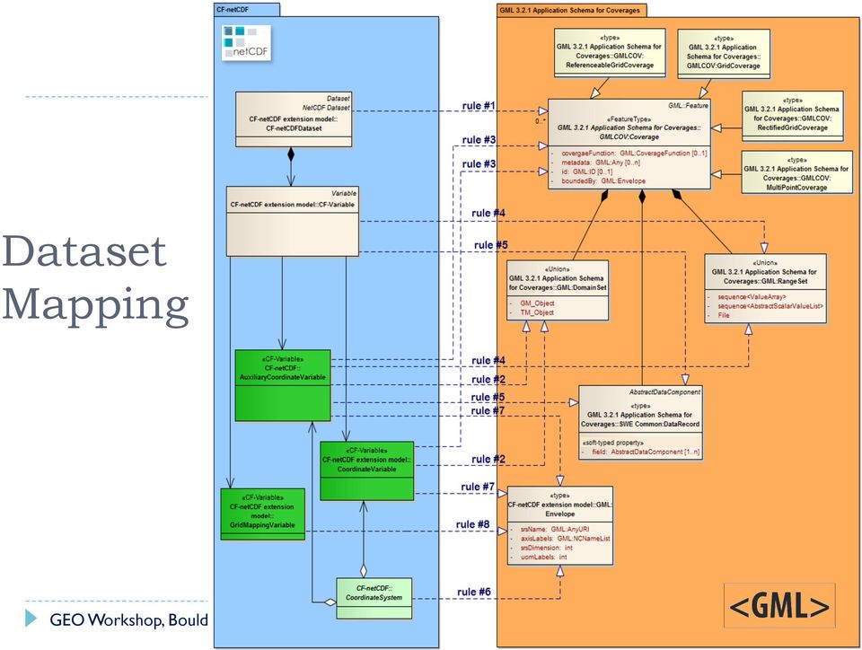
13 Dataset Mapping
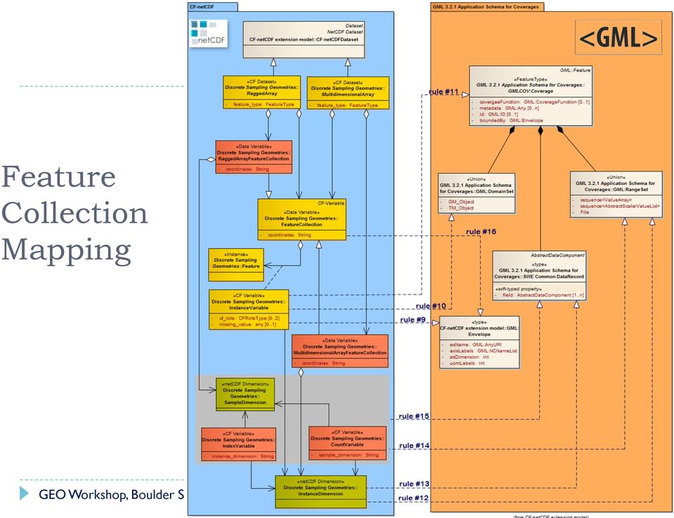
14 Feature Collection Mapping
15 GetCoverage response } CF-netCDF data encoding structure returned by a successful request shall implement a Discrete Coverage File realized according to this specific model

16 Broker Climate data tools } Extended the CSW by adding distribution and mediation } Broker THREDDS/OPeNDAP and make it accessible through OGC CSW (OpenSearch-GEO and OAI- PMH) Extend standards Broker tools
 Extend standards")
17 TDS: an Inventory and Access services } TDS published services: } TDS inventory service } WCS, WMS, } TDS accessed resources: } NetCDF files and folders } GRIB2, HDF, } OPeNDAP resources TDS Inventory/nc/ISO (NOAA) OGC WCS OGC WMS
 OGC")
18 From Inventory/Access to Catalog service } GI-cat published services } CSW } OpenSearch } OAI-PMH } } GI-cat accessed resources: } THREDDS inventory service } WCS, WMS (WFS, WPS, SOS) } NetCDF, ncml } CSW OpenSearch OAI-PMH TDS Inventory/ncISO WCS WMS
 } NetCDF, ncml } CSW OpenSearch OAI-PMH TDS")
19 OGC CS-W General Functional Model CatalogService 1 Discovery +describerecordtype() +gerdomain() +present() +query() Mandatory Manager Session BrokeredAccess +harvestrecords() +transaction() +cancel() +close() +initialize() +status() +order() } CS-W functionalities } Mandatory capabilities } offline order } Discovery Metadata Query & Present (e.g. getrecords, getrecordsbyid, describerecord) Optional capabilities } Session (e.g. initialize, close, status) } Management (e.g. harvest, transaction)
 Optional capabilities } Session (e.g. initialize, close, status) } Management (e.g. harvest, transaction)")
20 Extended Functional Model introducing Distribution & Mediation } Extended model for a Mediation Catalog service (Catalog Broker) } Extended functionalities Mediation GI-Cat Catalog Service 1 Discovery getcontent getmetadata query Mandatory Session Messaging Persistency Distribution Mediation & Access commit init login logout rollback publish subscribe unsubscribe purge store add remove getmapping setmapping Stateful behavior Transaction Asynchronous interaction Caching Federation of new service instances Mapping heterogeneous service modesl to the federation one

21 Profilers Common Data Model Distributor Harversters Accessors OWS Accessors OpenSearch Asynchronous messaging CS- W AP Accessors CS- W(T)/ ISO AP CS-W/ ebrim-cim AP CS-W/ ebrim-eo AP ISO 19115, , Extensions (eb- RIM/CIM /EO, GBIF, SWE). GBIF Accessor OpenSearch Accessor THREDDS/ OPeNDAP Accessor CDI Accessor ESRI CSW OAI- PMH Accessor GeoRSS Accessor OAI-PMH empowered by Extended Interface RIM- EO, RIM- CIM, ISO Local Repositories netcdf Accessor
22 Thank you for your attention! Stefano Nativi:
23 CF-netCDF Dataset Mapping to ISO19123:CV_DiscreteCoverage
24 CF-netCDF SamplingGeometries Mapping to ISO19123:CV_DiscreteCoverage
25 Serve CF-netCDF datasets } Mapping CF-netCDF data model to the ISO Coverage model } The CF extension to the netcdf core model } Extend WCS 2.0 Standard Interface to serve CF-NetCDF datasets } The CF-netCDF encoding format extension to OGC WCS 2.0 Data Model Service Interface protocol Operations Encoding schema Payload Data Model
CDI/THREDDS Interoperability: the SeaDataNet developments. P. Mazzetti 1,2, S. Nativi 1,2, 1. CNR-IMAA; 2. PIN-UNIFI
 CDI/THREDDS Interoperability: the SeaDataNet developments P. Mazzetti 1,2, S. Nativi 1,2, 1. CNR-IMAA; 2. PIN-UNIFI Outline Interoperability Issues in SeaDataNet A broker solution for CDI/THREDDS interoperability
The Arctic Observing Network and its Data Management Challenges Florence Fetterer (NSIDC/CIRES/CU), James A. Moore (NCAR/EOL), and the CADIS team
, James A. Moore (NCAR/EOL), and the CADIS team") The Arctic Observing Network and its Data Management Challenges Florence Fetterer (NSIDC/CIRES/CU), James A. Moore (NCAR/EOL), and the CADIS team Photo courtesy Andrew Mahoney NSF Vision What is AON? a
The Arctic Observing Network and its Data Management Challenges Florence Fetterer (NSIDC/CIRES/CU), James A. Moore (NCAR/EOL), and the CADIS team Photo courtesy Andrew Mahoney NSF Vision What is AON? a
Web-based spatio-temporal visualization and analysis of the Siberian Earth System Science Cluster (SIB-ESS-C)
") Web-based spatio-temporal visualization and analysis of the Siberian Earth System Science Cluster (SIB-ESS-C) Roman Gerlach Supervisor: Prof. C. Schmullius (Dept. of Geography, Friedrich-Schiller-University
Web-based spatio-temporal visualization and analysis of the Siberian Earth System Science Cluster (SIB-ESS-C) Roman Gerlach Supervisor: Prof. C. Schmullius (Dept. of Geography, Friedrich-Schiller-University
PART 1. Representations of atmospheric phenomena
 PART 1 Representations of atmospheric phenomena Atmospheric data meet all of the criteria for big data : they are large (high volume), generated or captured frequently (high velocity), and represent a
Standardized data sharing through an open-source Spatial Data Infrastructure: the Afromaison project
 Standardized data sharing through an open-source Spatial Data Infrastructure: the Afromaison project Yaniss Guigoz - University of Geneva/GRID-Geneva 1 EcoARM2ERA and AFROMAISON Why Afromaison in this
NetCDF and HDF Data in ArcGIS
 2013 Esri International User Conference July 8 12, 2013 San Diego, California Technical Workshop NetCDF and HDF Data in ArcGIS Nawajish Noman Kevin Butler Esri UC2013. Technical Workshop. Outline NetCDF
Spatial Data Infrastructures - trends and impacts on society. Max Craglia Joint Research Centre Digital Earth and Reference Data Unit
 Spatial Data Infrastructures - trends and impacts on society Max Craglia Joint Research Centre Digital Earth and Reference Data Unit Outline Where we were 20 years ago Where we are now Where we are going
The ORIENTGATE data platform
 Seminar on Proposed and Revised set of indicators June 4-5, 2014 - Belgrade (Serbia) The ORIENTGATE data platform WP2, Action 2.4 Alessandra Nuzzo, Sandro Fiore, Giovanni Aloisio Scientific Computing and
GeoNetwork, The Open Source Solution for the interoperable management of geospatial metadata
 GeoNetwork, The Open Source Solution for the interoperable management of geospatial metadata Ing. Simone Giannecchini, GeoSolutions Ing. Emanuele Tajariol, GeoSolutions Outline GeoNetwork Introduction
Metadata for Data Discovery: The NERC Data Catalogue Service. Steve Donegan
 Metadata for Data Discovery: The NERC Data Catalogue Service Steve Donegan Introduction NERC, Science and Data Centres NERC Discovery Metadata The Data Catalogue Service NERC Data Services Case study:
GeoNetwork, The Open Source Solution for the interoperable management of geospatial metadata
 GeoNetwork, The Open Source Solution for the interoperable management of geospatial metadata Ing. Emanuele Tajariol, GeoSolutions Ing. Simone Giannecchini, GeoSolutions GeoSolutions GeoSolutions GeoNetwork
GOSIC NEXRAD NIDIS NOMADS
 NOAA National Climatic Data Center GOSIC NEXRAD NIDIS NOMADS Christina Lief NOAA/NESDIS/NCDC GOSIC Program Manager NOAA/NESDIS/NCDC Asheville, NC 28801 GEOSS AIP Phase 2 Workshop September 25-26, 2008
OGC at KNMI: Current use and plans Available products
 OGC at KNMI: Current use and plans Available products Maarten Plieger KNMI R&D Ernst de Vreede, John van de Vegte, Wim Som de Cerff, Ian van der Neut, Raymond Sluiter, Jan Willem Noteboom Contents 1. ADAGUC
EED Task Order. Contract: NNG10HP02C Contractor: Raytheon Task Type:
 EED Task Order Title: Studies CMR Phase 0 No-Cost Extension Task Number: 9 Rev 15 Originator: Marinelli Effective Date: Dec 11, 2013 ESDIS POC: Marinelli Task Estimate Cost and Maximum Available Fee Estimate
The THREDDS Data Repository: for Long Term Data Storage and Access
 8B.7 The THREDDS Data Repository: for Long Term Data Storage and Access Anne Wilson, Thomas Baltzer, John Caron Unidata Program Center, UCAR, Boulder, CO 1 INTRODUCTION In order to better manage ever increasing
The ORIENTGATE data platform
 Research Papers Issue RP0195 December 2013 The ORIENTGATE data platform SCO Scientific Computing and Operations Division By Alessandra Nuzzo University of Salento and Scientific Computing and Operations
INTEROPERABLE IMAGE DATA ACCESS THROUGH ARCGIS SERVER
 INTEROPERABLE IMAGE DATA ACCESS THROUGH ARCGIS SERVER Qian Liu Environmental Systems Research Institute 380 New York Street Redlands, CA92373, U.S.A - [email protected] KEY WORDS: OGC, Standard, Interoperability,
THREDDS. THematic Real-time Environmental Distributed Data Services. Connecting people, documents and data
 THREDDS THematic Real-time Environmental Distributed Data Services Connecting people, documents and data Ben Domenico, John Caron, Ethan Davis, Robb Kambic, Stefano Nativi Unidata Program Center and University
Open Source Visualisation with ADAGUC Web Map Services
 Open Source Visualisation with ADAGUC Web Map Services Maarten Plieger Ernst de Vreede John van de Vegte, Wim Som de Cerff, Raymond Sluiter, Ian van der Neut, Jan Willem Noteboom 1 ADAGUC project Cooperative
SeaDataNet pan-european infrastructure for ocean and marine data management and its relation to EMODNet and GEOSS
 SeaDataNet pan-european infrastructure for ocean and marine data management and its relation to EMODNet and GEOSS By Dick M.A. Schaap MARIS SeaDataNet Technical Coordinator Madrid Spain, 26 January 2012,
Access to ESPON Database by third- party applications An expertise on the potentialities of web services for accessing the ESPON metadata and data
 Access to ESPON Database by third- party applications An expertise on the potentialities of web services for accessing the ESPON metadata and data UNEP/GRID- Geneva 27/06/2013 ABOUT THIS DOCUMENT A technical
Catalogue or Register? A Comparison of Standards for Managing Geospatial Metadata
 Catalogue or Register? A Comparison of Standards for Managing Geospatial Metadata Gerhard JOOS and Lydia GIETLER Abstract Publication of information items of any kind for discovery purposes is getting
Scientific Data Management and Dissemination
 Federal GIS Conference February 9 10, 2015 Washington, DC Scientific Data Management and Dissemination John Fry Solution Engineer, Esri [email protected] Agenda Background of Scientific Data Management through
GIS Initiative: Developing an atmospheric data model for GIS. Olga Wilhelmi (ESIG), Jennifer Boehnert (RAP/ESIG) and Terri Betancourt (RAP)
, Jennifer Boehnert (RAP/ESIG) and Terri Betancourt (RAP)") GIS Initiative: Developing an atmospheric data model for GIS Olga Wilhelmi (ESIG), Jennifer Boehnert (RAP/ESIG) and Terri Betancourt (RAP) Unidata seminar August 30, 2004 Presentation Outline Overview
GIS Initiative: Developing an atmospheric data model for GIS Olga Wilhelmi (ESIG), Jennifer Boehnert (RAP/ESIG) and Terri Betancourt (RAP) Unidata seminar August 30, 2004 Presentation Outline Overview
DEVELOPMENT OF THE INTEGRATING AND SHARING PLATFORM OF SPATIAL WEBSERVICES
 DEVELOPMENT OF THE INTEGRATING AND SHARING PLATFORM OF SPATIAL WEBSERVICES Lan Xiaoji 1,2 Lu Guonian 1 Zhang Shuliang 1 Shi Miaomiao 1 Yin Lili 1 1. Jiangsu Provincial Key Lab of GIS Science, Nanjing Normal
Model examples Store and provide Challenges WCS and OPeNDAP Recommendations. WCS versus OPeNDAP. Making model results available through the internet.
 Making model results available through the internet. Fedor Baart, Gerben de Boer, Wim de Haas, Gennadiy Donchyts, Marc Philippart, Maarten Plieger September 14, 2011 Introduction Fedor Baart PhD thesis:
Introduction to Geospatial Web Services
 Geospatial Web Services Introduction to Geospatial Web Services An introduction and inventory of geospatial web services and their importance to interoperability in the geospatial domain. vers. 20100604
An Esri White Paper June 2011 ArcGIS for INSPIRE
 An Esri White Paper June 2011 ArcGIS for INSPIRE Esri, 380 New York St., Redlands, CA 92373-8100 USA TEL 909-793-2853 FAX 909-793-5953 E-MAIL [email protected] WEB esri.com Copyright 2011 Esri All rights reserved.
Nevada NSF EPSCoR Track 1 Data Management Plan
 Nevada NSF EPSCoR Track 1 Data Management Plan August 1, 2011 INTRODUCTION Our data management plan is driven by the overall project goals and aims to ensure that the following are achieved: Assure that
DATA ACCESS AT EUMETSAT
 1 EUM/OPS/VWG/15/793789 v1a DATA ACCESS AT EUMETSAT Copernicus Climate Data Store Workshop ECMWF 3-6 March 2015 Harald Rothfuss Overview of Presentation 1. Introduction to EUMETSAT 2. EUMETSAT Data Access
Sextant. Spatial Data Infrastructure for Marine Environment. C. Satra Le Bris, E. Quimbert, M. Treguer
 Sextant On-Line information system for marine geographical information E. Quimbert, M. Bellouis, F. Lecuy, M. Treguer Centre de Bretagne BP 70, Plouzané 29280 France E-mail: [email protected] Sextant
WCS as a Download Service for Big (and Small) Data
 Data") WCS as a Download Service for Big (and Small) Data INSPIRE 2013 Florence, Italy, 2013-jun-25 Peter Baumann 1, Stephan Meissl 2, Alan Beccati 1 1 Jacobs University rasdaman GmbH, Bremen, Germany 2 EOX GmbH,
WCS as a Download Service for Big (and Small) Data INSPIRE 2013 Florence, Italy, 2013-jun-25 Peter Baumann 1, Stephan Meissl 2, Alan Beccati 1 1 Jacobs University rasdaman GmbH, Bremen, Germany 2 EOX GmbH,
REACCH PNA Data Management Plan
 REACCH PNA Data Management Plan Regional Approaches to Climate Change (REACCH) For Pacific Northwest Agriculture 875 Perimeter Drive MS 2339 Moscow, ID 83844-2339 http://www.reacchpna.org [email protected]
13.2 THE INTEGRATED DATA VIEWER A WEB-ENABLED APPLICATION FOR SCIENTIFIC ANALYSIS AND VISUALIZATION
 13.2 THE INTEGRATED DATA VIEWER A WEB-ENABLED APPLICATION FOR SCIENTIFIC ANALYSIS AND VISUALIZATION Don Murray*, Jeff McWhirter, Stuart Wier, Steve Emmerson Unidata Program Center, Boulder, Colorado 1.
National Geothermal Data System and Global Geosciences Data Integration
 National Geothermal Data System and Global Geosciences Data Integration Lee Allison, AZGS Stephen Richard, AZGS Arlene Anderson, US DOE David Cuyler, US DOE & Sandia Natl Lab NERC 2008 Outline Rational
The NERC DataGrid (NDG)
") The NERC DataGrid (NDG) Roy Lowry on behalf of the NDG, BADC and BODC. Ray Cramer, Marta Gutierrez, Kerstin Kleese Van Dam, Venkatasiva Kondapalli, Susan Latham, Bryan Lawrence, Kevin O Neill, Ag Stephens,
The NERC DataGrid (NDG) Roy Lowry on behalf of the NDG, BADC and BODC. Ray Cramer, Marta Gutierrez, Kerstin Kleese Van Dam, Venkatasiva Kondapalli, Susan Latham, Bryan Lawrence, Kevin O Neill, Ag Stephens,
System Requirements for Archiving Electronic Records PROS 99/007 Specification 1. Public Record Office Victoria
 System Requirements for Archiving Electronic Records PROS 99/007 Specification 1 Public Record Office Victoria Version 1.0 April 2000 PROS 99/007 Specification 1: System Requirements for Archiving Electronic
GIS Data Models for INSPIRE and ELF
 GIS Data Models for INSPIRE and ELF Paul Hardy Roberto Lucchi EuroSDR/ELF Copenhagen Data Modelling and Model Driven Implementation of Data Distribution 28 Jan 2015 ArcGIS for INSPIRE Extends ArcGIS for
Building integration environment based on OAI-PMH protocol. Novytskyi Oleksandr Institute of Software Systems NAS Ukraine [email protected].
 Building integration environment based on OAI-PMH protocol Novytskyi Oleksandr Institute of Software Systems NAS Ukraine [email protected] Roadmap What is OAI-PMH? Requirements for infrastructure Step by
EUMETSAT EO Portal. End User Image Access using OGC WMS/WCS services. EUM/OPS/VWG/10/0095 Issue <1> <14/01/2010> Slide: 1
 EUMETSAT EO Portal End User Image Access using OGC WMS/WCS services Slide: 1 Overview Introduction: status of data access and visualization EUMETSAT datasets Architecture Web Map Service implementation
Adding Big Earth Data Analytics to GEOSS
 Research funded through EU FP7 283610 EarthServer European Scalable Earth Science Service Environment Adding Big Earth Data Analytics to GEOSS GEO IX Plenary Foz do Iguacu, 2012-nov-20 Peter Baumann, Stefano
Steve Ansari *, Stephen Del Greco, Brian Nelson, and Helen Frederick NOAA National Climatic Data Center, Asheville, North Carolina 2.
 11.4 THE SEVERE WEATHER DATA INVENTORY (SWDI): SPATIAL QUERY TOOLS, WEB SERVICES AND DATA PORTALS AT NOAA S NATIONAL CLIMATIC DATA CENTER (NCDC) Steve Ansari *, Stephen Del Greco, Brian Nelson, and Helen
A standards-based open source processing chain for ocean modeling in the GEOSS Architecture Implementation Pilot Phase 8 (AIP-8)
") NATO Science & Technology Organization Centre for Maritime Research and Experimentation (STO-CMRE) Viale San Bartolomeo, 400 19126 La Spezia, Italy A standards-based open source processing chain for ocean
NATO Science & Technology Organization Centre for Maritime Research and Experimentation (STO-CMRE) Viale San Bartolomeo, 400 19126 La Spezia, Italy A standards-based open source processing chain for ocean
NOMADS. Jordan Alpert, Jun Wang NCEP/NWS. Jordan C. Alpert [email protected]. where the nation s climate and weather services begin
 An Application for High Availability NOMADS Jordan Alpert, Jun Wang NCEP/NWS Jordan C. Alpert [email protected] DMIT Workshop, Silver Spring, MD 8/13-14//2009 where the nation s climate and weather
Standards Required to Support XML-Based B2B Integration
 Standards Required to Support XML-Based B2B Integration A conceptual model for understanding XML convergence Companies across all industries are realizing the fundamental benefits of using the Internet
CERN Document Server
 CERN Document Server Document Management System for Grey Literature in Networked Environment Martin Vesely CERN Geneva, Switzerland GL5, December 4-5, 2003 Amsterdam, The Netherlands Overview Searching
StormSurgeViz: A Visualization and Analysis Application for Distributed ADCIRC-based Coastal Storm Surge, Inundation, and Wave Modeling
 : A Visualization and Analysis Application for Distributed ADCIRC-based Coastal Storm Surge, Inundation, and Wave Modeling Brian Blanton Renaissance Computing Institute University of North Carolina at
GEOCOM PROJECT INTEGRATING DATA & TECHONOLOGIES
 GEOCOM PROJECT INTEGRATING DATA & TECHONOLOGIES Lucio Colaiacomo Chief Technology Officer [email protected] Rationale for the project Providing support through our domain background & tech. expertise
VISUAL INSPECTION OF EO DATA AND PRODUCTS - OVERVIEW
 WMS services from the EUMETSAT real-time Image Gallery Uwe Voges (1), Michael Schick (2), Udo Einspanier (1) (1) con terra GmbH Martin-Luther-King-Weg 24, 48155, Münster, Germany EMail: (U.Voges U.Einspanier)@conterra.de
 Integrated Data Viewer (IDV) a visualization framework Yuan Ho Unidata Program Center Boulder, CO Presentation Outline Integrated Data Viewer (IDV) overview The IDV features IDV examples and customized
Structure? Integrated Climate Data Center How to use the ICDC? Tools? Data Formats? User
 Integrated Climate Data Center? Data Formats?? Tools???? visits Structure???? User Contents Which Data Formats do we offer? What is the Structure of our data center? Which Tools do we provide? Our Aims
GetLOD - Linked Open Data and Spatial Data Infrastructures
 GetLOD - Linked Open Data and Spatial Data Infrastructures W3C Linked Open Data LOD2014 Roma, 20-21 February 2014 Stefano Pezzi, Massimo Zotti, Giovanni Ciardi, Massimo Fustini Agenda Context Geoportal
Data-Intensive Science and Scientific Data Infrastructure
 Data-Intensive Science and Scientific Data Infrastructure Russ Rew, UCAR Unidata ICTP Advanced School on High Performance and Grid Computing 13 April 2011 Overview Data-intensive science Publishing scientific
Data Management Perspective for an International Arctic Observing Network: Preserving the Legacy Promoting Exchange
 Data Management Perspective for an International Arctic Observing Network: Preserving the Legacy Promoting Exchange James A. Moore 1 Molly McCammon 2 Rob Bochenek 3 1 National Center for Atmospheric Research,
MEETING TOMORROW S EARTH OBSERVATION CHALLENGES _ WHITE PAPER
 MEETING TOMORROW S EARTH OBSERVATION CHALLENGES _ WHITE PAPER CONTENTS I. INTRODUCTION 3 II. CHALLENGES FOR TOMORROW S EARTH OBSERVATION APPLICATIONS 4 III. CONNECT, VISUALIZE, ANALYZE, ACT: LUCIAD AS
MultiMimsy database extractions and OAI repositories at the Museum of London
 MultiMimsy database extractions and OAI repositories at the Museum of London Mia Ridge Museum Systems Team Museum of London [email protected] Scope Extractions from the MultiMimsy 2000/MultiMimsy
ArcGIS Framework Plug-In: Extending the ArcGIS Desktop for ANSI Standard Framework Data to Support Government Decision Making
 ArcGIS Framework Plug-In: Extending the ArcGIS Desktop for ANSI Standard Framework Data to Support Government Decision Making Final Project Report October 28, 2008 Agreement Number Organization Project
A Big Picture for Big Data
 Supported by EU FP7 SCIDIP-ES, EU FP7 EarthServer A Big Picture for Big Data FOSS4G-Europe, Bremen, 2014-07-15 Peter Baumann Jacobs University rasdaman GmbH [email protected] Our Stds Involvement
African European Georesources Observation System
 African European Georesources Observation System Spatial Data Infrastructure (SDI) Dr. Andreas Barth, Bernd Torchala Beak, Germany Outline Project Overview AEGOS SDI data / services hardware / software
Pan-European infrastructure for management of marine and ocean geological and geophysical data
 Pan-European infrastructure for management of marine and ocean geological and geophysical data By Dick M.A. Schaap Geo-Seas Technical Coordinator March 2010 Supported by the European Commission FP7 - Research
Interoperable Solutions in Web-based Mapping
 ISPRS SIPT IGU UCI CIG ACSG Table of contents Table des matières Authors index Index des auteurs Search Recherches Exit Sortir Interoperable Solutions in Web-based Mapping Marta Wojnarowska and Bridget
The distribution of marine OpenData via distributed data networks and Web APIs. The example of ERDDAP, the message broker and data mediator from NOAA
 The distribution of marine OpenData via distributed data networks and Web APIs. The example of ERDDAP, the message broker and data mediator from NOAA Dr. Conor Delaney 9 April 2014 GeoMaritime, London
GIS AS A DECISION SUPPORT FOR SUPPLY CHAIN MANAGEMENT
 Paper Reference No.: PN-253 GIS AS A DECISION SUPPORT FOR SUPPLY CHAIN MANAGEMENT Sanjay Kumar 1 and Suneeta Agrawal 2 1. M. Tech. (GIS & Remote Sensing); GIS Cell; MNNIT, Allahabad, India (E-mail: [email protected])
Parallel storage, mining and visualization of environmental data archives
 Parallel storage, mining and visualization of environmental data archives Mikhail Zhizhin, Dmitry Medvedev, Alexey Poyda, Dmitry Mishin and Sergei Berezin Space Research Institute and Geophysical Center
GEOG 482/582 : GIS Data Management. Lesson 10: Enterprise GIS Data Management Strategies GEOG 482/582 / My Course / University of Washington
 GEOG 482/582 : GIS Data Management Lesson 10: Enterprise GIS Data Management Strategies Overview Learning Objective Questions: 1. What are challenges for multi-user database environments? 2. What is Enterprise
Research Data Collection Data Management Plan
 Research Data Collection Data Management Plan This document records the whole process of the data collections, including pre- preparation data,
Databases & Data Infrastructure. Kerstin Lehnert
 + Databases & Data Infrastructure Kerstin Lehnert + Access to Data is Needed 2 to allow verification of research results to allow re-use of data + The road to reuse is perilous (1) 3 Accessibility Discovery,