MAREMED kick off meeting
|
|
|
- Raymond Cooper
- 10 years ago
- Views:
Transcription
1 MAREMED kick off meeting MEDITERRANEAN BASIN (Italy) Spatial Planning Department Orietta Gattulli economic management Marino Fiorito computer service center 22 June 2010 REGION PROVENCE-ALPES-CÔTE D AZUR - MARSEILLE

2 Liguria Region in the Mediterranean Basin

3 Liguria at a glance Savona Genova La Spezia Imperia 4 Provinces (Imperia, Savona, Genova, La Spezia) 235 Total municipalities 63 Costal municipalities Genova regional capital town Land area: sq. km

4 Coastal physical characteristics: 40% beaches 21% high coast 14% coastal defense structures 12% embankment 8% rocky shoreline 5% river mouths Erosion, Pollution, conflicts among users: maritime transportations, can be occasion for to marine pollution; illegal waste discharge and, oil spill, affect biodiversity conservation, fishery resources, and tourist use of our coast Extreme meteorological events: Floodings, landslides, sea storms Geographical data Population: Inhabitants (2008) 1000 inhabitants/sq. km on the coastal area 70 inhabitants/sq. km inland Core activity: ports, tertiary, industry, tourism
 1000 inhabitants/sq. km on the coastal area 70 inhabitants/sq.")
5 Region s ports distribution LOANO VARAZZE CELLE SAVONA VADO LIGURE FINALE LIGURE ARENZANO GENOVA GE-NERVI CAMOGLI PORTOFINO RAPALLO SANTA MARGHERITA LIGURE CHIAVARI LAVAGNA FRAMURA SESTRI LEVANTE LEVANTO MONTEROSSO AL MARE VERNAZZA ALASSIO ISOLA - GALLINARA LERICI PORTOVENERE AMEGLIA LA SPEZIA SANREMO OSPEDALETTI BORDIGHERA SAN LORENZO AL MARE SANTO STEFANO AL MARE RIVA LIGURE TAGGIA ANDORA SAN BARTOLOMEO AL MARE DIANO MARINA IMPERIA 49 Marinas 15 Smaller marinas 3 major Commercial port areas

6 Region s competencies on the coast TERRITORIAL AND URBAN PLANNING MARINE AND COASTAL ENVIRONMENT COASTAL DEFENCE MARITIME PUBLIC DOMAIN PORTS FISHERY AND AQUACOLTURE TOURISM PROTECTED AREAS AND BIODIVERSITY

7 Region s structure involved in the project Dipartimento Pianificazione Territoriale, Urbanistica Aree Demaniali Marittime Dipartimento Ambiente Ecosistema Costiero Dipartimento Agricoltura, Turismo e Cultura Produzioni Agroalimentari Dipartimento Trasporti, Porti, Lavori pubblici ed edilizia Porti e Logistica

8 Governance and Budget Political representant and offices: no political representant no office dedicated to maritime affairs several offices follow the different aspects but usually there is a good relationship among them. To have had a comprehensive Plan as the Piano della Costa was useful for building a common attitude towards the coastal matters. Budget: there is no possibility to identify the budget categories affected to the maritime affairs. International policy: according with the importance of his maritime cluster Liguria has a particular activity in the international relationship related with shipping, maritime transportation, shipyard activities, maritime professions.

9 Regional Information System regional RDBMS intranet Territorial Planning data SiCoast data Maritime works Beaches PMD Coastline evolution web services wms / wfs internet

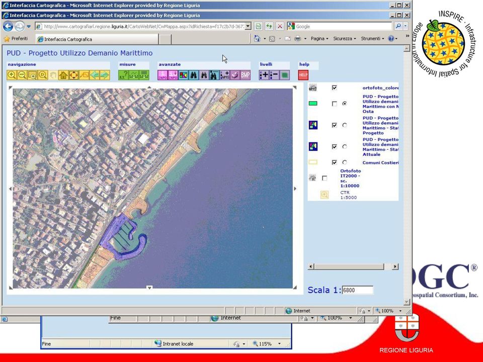
10 Websites and public data

11 Client http Alpha Ms 2003 sever IIS 6 Asp Php Gis Ms 2003 sever Apache Mapserver Php intranet Presentation logic, Application logic Client wms/wfs Alpha Data for alphanumeric applications Oracle 10g Gis Spatial data Data Management The intranet: geodata

12 Client http Alpha Ms 2003 sever IIS 6 Asp Php Gis Ms 2003 sever Apache Mapserver Php intranet Presentation logic, Application logic Client wms/wfs Alpha Data for alphanumeric applications Oracle 10g Gis Spatial data Data Management The Intranet: Alpha data

13 All public data: Coast public data: Environment public data: Alpha Data for alphanumeric applications Oracle 10g Client http Gis Spatial data internet Data Management Client wms/wfs Geo Web Ms 2003 IIS 6 Mapsever Image web Asp /.Net Presentation logic, Application logic Public data

14 Client http Alpha Ms 2003 sever IIS 6 Asp Gis Ms 2003 sever Apache Mapserver Php intranet Presentation logic, Application logic Client wms/wfs Alpha Data for alphanumeric applications Oracle 10g Client http Gis Spatial data internet Data Management Client wms/wfs Geo Web Ms 2003 IIS 6 Mapsever Image web Asp /.Net Presentation logic, Application logic

15 Website of Regione Liguria exposes its map layers trough WMS and WFS (only for authorized users) service. Users can access at WMS / WFS services trough internet and add them to their maps, one by one

16 only for authorized users

17
18 MAREMED Kick off meeting THANK YOU

The cycling routes project of Liguria
 The cycling routes project of Liguria Dipartimento Programmi Regionali, Porti,Trasporti, Lavori Pubblici ed Edilizia Settore Pianificazione e valutazione interventi Eurovelo and BicItalia Liguria is only
Progress of SIGC -Coastal Geographical Information System
 Progress of SIGC -Coastal Geographical Information System Filippo D Ascola, Angela Barbano ISPRA -Istituto Superiore per la Protezione e la Ricerca Ambientale Dip.to Tutela Acque Interne e Marine - Servizio
Climate change impacts on city of Gdansk and its vicinity (Vistula Delta, Poland)
") Final International ASTRA Conference Espoo, 10-11 December, 2007 Climate change impacts on city of Gdansk and its vicinity (Vistula Delta, Poland) Dorota Kaulbarsz, Zbigniew Kordalski, Wojciech Jeglinski
Final International ASTRA Conference Espoo, 10-11 December, 2007 Climate change impacts on city of Gdansk and its vicinity (Vistula Delta, Poland) Dorota Kaulbarsz, Zbigniew Kordalski, Wojciech Jeglinski
Figure 2: System Flow Diagram for Workflow Management
 5. WORKFLOW MANAGEMENT The developed system EASKB uses the open source content management system called Drupal ([2]). A Content Management System - CMS is a tool that enables many user friendly features
A.P.I.C.E. Common Mediterranean strategy and local practical Actions for the mitigation of Port, Industries and Cities Emissions
 A.P.I.C.E. Common Mediterranean strategy and local practical Actions for the mitigation of Port, Industries and Cities Emissions The study area of Venice ARPA Veneto and Veneto Region Kick off meeting
INFRASTRUCTURE: Examples from Brazil
 INTERNATIONAL APPLICATIONS OF GREEN INFRASTRUCTURE: Examples from Brazil October 12, 2011 Webinar Conservation Leadership Network The Conservation Fund Denise Levy Denise Levy Environmental Safeguards
Porto La Spezia, Italia. the sustainable regeneration of an urban waterfront JM Tomás Llavador, architect
 Porto La Spezia, Italia the sustainable regeneration of an urban waterfront JM Tomás Llavador, architect Londres Paris Madrid La Spezia Roma portovenere sciacchetrà cinque-terre lerici Lerici, 1933 Fillia
ON JANUARY 7TH, 2012, THE COSTA CONCORDIA DEPARTED FROM THE PORT OF SAVONA TO
 ON JANUARY 7TH, 2012, THE COSTA CONCORDIA DEPARTED FROM THE PORT OF SAVONA TO BEGIN AN 8 DAY CRUISE IN THE MEDITERRANEAN SEA WITH EXPECTED RETURN IN SAVONA ON JANUARY 14TH. ON JANUARY 13TH AT 20:18 LOCAL
Cinque Terre Frequently asked questions
 www.coastalwalking.com 2014 Page 1 Cinque Terre Frequently asked questions Where is Cinque Terre located? Cinque Terre is located in the northwest of Italy. It is a part of Liguria, one of the 20 regions
A DAY FOR CARTOGRAPHIC SYSTEMS TO MANAGE COASTAL ZONES
 A DAY FOR CARTOGRAPHIC SYSTEMS TO MANAGE COASTAL ZONES Coastal and maritime data: common heritage, a capital to be shared, a challenge for innovation in Europe 10th December 2009 Provence-Alpes-Côte d
Project for the development of the Cultural Heritage of Axis 4 of the POR FESR 2007-2013 LIGURIA HERITAGE. www.liguriaheritage.it
 Project for the development of the Cultural Heritage of Axis 4 of the POR FESR 2007-2013 LIGURIA HERITAGE www.liguriaheritage.it LIGURIA HERITAGE www.liguriaheritage.it Liguria Heritage: an original project
Observing and Monitoring the Visitor Use in Marine Protected Areas 1
 Observing and Monitoring the Visitor Use in Marine Protected Areas 1 Tourism as an opportunity Tourism is a source of employment and foreign currencies, and greatly contributes to economic development
SMART PORT PROJECT. SMART PORT PROJECT T1. Description of Med ports current situation
 Blue Energies in the Mediterranean Sea MARSEILLE 10-11 December 2014 ROUND-TABLE II INVESTING IN THE MEDITERRANEAN POTENTIAL FOR MARINE RENEWABLE ENERGIES SMART PORT PROJECT SMART PORT PROJECT Gustavo
Program of the Event THREE DAYS OF WELLNESS, GASTRONOMY AND ITALIAN LIFESTYLE FOR YACHT CAPTAINS & OWNERS IN THE WONDERFUL LIGURIAN RIVIERA SETTING
 In partnership with present THREE DAYS OF WELLNESS, GASTRONOMY AND ITALIAN LIFESTYLE FOR YACHT CAPTAINS & OWNERS IN THE WONDERFUL LIGURIAN RIVIERA SETTING Program of the Event «We would like to thank you
The Application of Law on Pollution Control towards Marine Biodiversity Conservation in Malaysia
 2011 International Conference on Environment and BioScience IPCBEE vol.21 (2011) (2011) IACSIT Press, Singapore The Application of Law on Pollution Control towards Marine Biodiversity Conservation in Malaysia
Advanced Electronic Not Invasive Buoy-Field System. System Description and Application
 Advanced Electronic Not Invasive Buoy-Field System System Description and Application What is MarPark MarPark is an innovative mooring system, based on electronic and not invasive buoys, studied for a
Liguria - Love at First Sight
 Liguria - Love at First Sight Vernazza - La Spezia (Bryan Reinhart/Masterfile) Seaside emotions Art Settings History Trail Scents and flavours Sports itineraries A sea of gardens Seaside emotions Sea Gourmet
Experiences in the application of Espoo Convention Spain
 Environmental Impact Assessment in Spain Experiences in the application of Espoo Convention Spain Aurora Hernando Garcinuño Subdirección General de Evaluación Ambiental Ministerio de Medio Ambiente y Medio
GENOA - IMPERIA - SAVONA - VADO LIGURE GIOIA TAURO - CROTONE - VIBO VALENTIA P&I
 Services we provide Ferpandi S.r.l. was established in Genoa in the early 1980 s committed to provide P&I Clubs and their members with the highest level of service by a team of qualified persons with a
coastal routes in Liguria
 15 coastal routes in Liguria In these places beside the sea San Remo, Bordighera, Alassio, Albenga, Varigotti, Finale Ligure, Spotorno, Bergeggi... and more still Portofino, Santa Margherita, Sestri Levante,
SECTION 10.0 MANAGEMENT UNIT 5: HORNSEA
 10.1 Summary Information 10.1.1 Location SECTION 10.0 MANAGEMENT UNIT 5: HORNSEA The limits of Management Unit 5, a 2.9km stretch of shoreline fronting the town of Hornsea on the Holderness coast, are
Country overview and assessment
 2. BULGARIA This country fiche provides a comprehensive overview and assessment of climate change adaptation in Bulgaria. After detailing the vulnerability of Bulgaria s coastal zones, the responsibility
CUBA CONFRONTING CLIMATE CHANGE
 CUBA CONFRONTING CLIMATE CHANGE CUBA: Main Characteristics Total population: 11.2 millions Length of the Island of Cuba: 1,200 Km. Maximum Width: 191 Km. Minimum Width: 31 Km. More than 4,000 islands and
Coastal Erosion Risk Mitigation Strategies applied in a Small Island Developing State: The Barbados Model
 Coastal Erosion Risk Mitigation Strategies applied in a Small Island Developing State: The Barbados Model BY Dr. Leo Brewster, Director Coastal Zone Management Unit, Barbados Presented At UNFCCC Expert
Survey and Mapping Activities in Vietnam *
 UNITED NATIONS E/CONF.100/CRP.1 ECONOMIC AND SOCIAL COUNCIL Eighteenth United Nations Regional Cartographic Conference for Asia and the Pacific Bangkok, 26-29 October 2009 Item 7(a) of the provisional
THE LIVORNO PLATFORM
 THE LIVORNO PLATFORM Operational capabilities of the Livorno transport and logistics platform the infrastructures and services, intangible assets, the main development projects The Port of Livorno Livorno
Implementation of Almada s Adaptation Strategy: a multi-level approach.
 Implementation of Almada s Adaptation Strategy: a multi-level approach. Nuno Lopes, Sara Dionísio, Patrícia Silva & Catarina Freitas Head of the Environmental Studies and Management Division Sustainable
DISASTER RISK DETECTION AND MANAGEMENT COURSES SETUP SCENARIO AT MAKERERE UNIVERSITY. Makerere University
 DISASTER RISK DETECTION AND MANAGEMENT COURSES SETUP SCENARIO AT MAKERERE UNIVERSITY CASE OF THE DEPARTMENT OF GEOGRAPHY Derek Muhwezi 2 MISSION OF THE DEPARTMENT To provide and promote quality education,
Nenad Mladineo. Marko Mladineo. Marin Stosic
 Nenad Mladineo University of Split, Faculty of Civil Engineering, Architecture and Geodesy, Croatia [email protected] Marko Mladineo University of Split, Faculty of Electrical Engineering, Mechanical,
2015 -- H 5478 S T A T E O F R H O D E I S L A N D
 LC00 01 -- H S T A T E O F R H O D E I S L A N D IN GENERAL ASSEMBLY JANUARY SESSION, A.D. 01 H O U S E R E S O L U T I O N CREATING THE RHODE ISLAND HOUSE COMMISSION ON ECONOMIC RISK DUE TO FLOODING AND
DISMAR implementing an OpenGIS compliant Marine Information Management System
 DISMAR implementing an OpenGIS compliant Marine Information Management System Éamonn Ó T uama, Coastal & Marine Resources Centre, ERI, University College Cork. DISMAR DISMAR (Data Integration System for
Basque-South Landes Coast EFF Group
 Overview of the territory Basque-South Landes Coast EFF Group Summary of the strategy The candidature is being led by the Bayonne maritime area Local Fishing Committee in partnership with the two regions
Prevention Pollution by Garbage from Ships in China. E Hailiang Deputy Director Maritime Safety Administration People s s Republic of China
 Prevention Pollution by Garbage from Ships in China E Hailiang Deputy Director Maritime Safety Administration People s s Republic of China 1 General Ship source garbage has been identified as one of the
THEMATIC GROUP STRATEGIC PLANNING AND TOURISM
 THEMATIC GROUP STRATEGIC PLANNING AND TOURISM Sergio Di Paolo, city of Genoa Sofia, July 2007 qmatters of language and concepts qmatters of experience and exchange (Genova, Istanbul, Oran) The territorial
Climate Change in Coastal Florida: Economic Impacts of Sea Level Rise
 Climate Change in Coastal Florida: Economic Impacts of Sea Level Rise CLIMTE CHNGE IN COSTL FLORID: ECONOMIC IMPCTS OF SE LEVEL RISE Context Global warming is expected to cause: Sea level rise Increased
Maritime Safety and Security
 Maritime Safety and Security - A Priority Area of the EU Strategy for the Baltic Sea Region Actions and activities in the Baltic Sea Region to secure a leading role in maritime safety and security The
Overview of Water Management in Turkey
 Overview of Water Management in Turkey The Istanbul Metropolitan Area case Selmin Burak Environmental Engineer Ph.D. Istanbul University, Institute of Marine Sciences&Management sburak@istanbul istanbul.edu.tr
U l t i m a t e e f f i c i e n c y D re D ging
 1 Ultimate efficiency Dredging We have a deep attitude. 2 Ultimate efficiency 3 Growth of global population, tourism, transportation of people and goods together with increased awareness of the need to
The Provincial Plan (PTC) is a general spatial planning tool approved in 2002 an actually under the decennial revision set by law.
 is a general spatial planning tool approved in 2002 an actually under the decennial revision set by law.") The Province of Genoa is a Public Authority acting at an intermediate level between municipalities and Liguria Region, and incorporates the territory of 67 municipalities. The main role is promoting and
The Province of Genoa is a Public Authority acting at an intermediate level between municipalities and Liguria Region, and incorporates the territory of 67 municipalities. The main role is promoting and
AMESD/MESA & GMES and Africa
 AMESD/MESA & GMES and Africa Jolly Wasambo AUC-REA Outline Background MESA: objective and expected results Thematic actions & services Some concerns about natural resources Land degradation Loss of soil
Practical Information for Participants
 Union for the Mediterranean High Level Conference on the financing of the future Trans-Mediterranean Transport Network (TMN-T) 'Porto di Roma' (Civitavecchia), 9 & 10 December 2014 Practical Information
ENVIRONMENTAL IMPACT ASSESSMENT PROCESS PROPOSED PHASE 2 EXPANSION OF THE TRANSNET IRON ORE HANDLING FACILITY, SALDANHA
 ENVIRONMENTAL IMPACT ASSESSMENT PROCESS PROPOSED PHASE 2 EXPANSION OF THE TRANSNET IRON ORE HANDLING FACILITY, SALDANHA BACKGROUND INFORMATION DOCUMENT 1 BACKGROUND Transnet Limited s (Transnet) existing
Regions of Portugal - Madeira
 Regions of - Area Why? The archipelago is made up of the following islands, Porto Santo, Desertas (three uninhabited Islands: Deserta Grande, Bugio and Ilhéu Chão) and the Nature Reserve of Selvagens has
no-entry only research and monitoring activities no-take zones incorporates other non-extractive uses
 Seaflower Biosphere Reserve Country: COLUMBIA Project Overview Columbia declared the archipelago of San Andres, Old Providence, and Santa Catalina a biosphere reserve called the Seaflower Biosphere Reserve.
Agua Hedionda Creek Flood Plain Information; Department of Army, Los Angeles District,
 Bibliography Agua Hedionda Creek Flood Plain Information; Department of Army, Los Angeles District, California and Maps. US Army Corps of Engineers July 1973 pg. 24 Aqua Hedionda Lagoon Foundation Framework
Tourist mature destinations as complex spaces. Notes about the elaboration process of an atlas of Costa del Sol
 Tourist mature destinations as complex spaces. Notes about the elaboration process of an atlas of Costa del Sol Sergio J. Reyes Corredera Universidad de Málaga, ETS Arquitectura, Málaga, España. e-mail:
EUROPEAN WATER RESOURCES AND POLICY
 EUROPEAN WATER RESOURCES AND POLICY What is the current water situation? The current water situation in Europe, according to a European Commission brochure, is described as: 20% of all surface water in
Development of a Dainish infrastructure for spatial information (DAISI) Brande-Lavridsen, Hanne; Jensen, Bent Hulegaard
 Brande-Lavridsen, Hanne; Jensen, Bent Hulegaard") Aalborg Universitet Development of a Dainish infrastructure for spatial information (DAISI) Brande-Lavridsen, Hanne; Jensen, Bent Hulegaard Published in: NORDGI : Nordic Geographic Information Publication
Aalborg Universitet Development of a Dainish infrastructure for spatial information (DAISI) Brande-Lavridsen, Hanne; Jensen, Bent Hulegaard Published in: NORDGI : Nordic Geographic Information Publication
2 nd Black Sea Stakeholders Conference Sofia, 24th March 2015 Background paper
 2 nd Black Sea Stakeholders Conference Sofia, 24th March 2015 Background paper Context... 2 EU IMP Blue Growth... 3 Recent developments of the EU IMP in the Black Sea... 4 Blue economy... 4 Marine knowledge...
Masters of Safety & Security. EUCISE2020 Industry Day Brussels September 23, 2015 SIGNALIS Presentation
 Masters of Safety & Security EUCISE2020 Industry Day Brussels September 23, 2015 SIGNALIS Presentation Ability to offer an end-to-end solution C2 Software & System Integration Electronics RADARS Sonars
Creating Green Jobs within the Environment and Culture sector.
 Creating Green Jobs within the Environment and Culture sector. Matilda Skosana Environmental Programmes (ILO Definition): 1. DEFINITION OF GREEN JOB. Jobs are green when they help reduce negative environmental
How to do it Manual No. 3: ArcMap10 in Remote Desktop mode and Landgate slip files. Jeremy Green
 How to do it Manual No. 3: ArcMap10 in Remote Desktop mode and Landgate slip files Jeremy Green Report Department of Maritime Archaeology No. 268 2010 Getting started with ArcInfo10 The ArcInfo10 exists
Philippines: ECO-TOWN FRAMEWORK
 Green Growth Initiatives in the Philippines: Demonstration of the ECO-TOWN FRAMEWORK Republic Act 9729 Climate Change Act of 2009 Acknowledge that local government units are the frontline agencies in the
Kristina Veidemane, Baltic Environmental Forum Panevezys, 12.05.2015
 Priority 2 Protection and restoration of biodiversity and soil and promotion of ecosystem services, including through Natura 2000, and green infrastructure Kristina Veidemane, Baltic Environmental Forum
OPRC Level II CONTINGENCY PLANNING, RESPONSE MANAGEMENT AND ORGANIZATION
 OPRC Level II CONTINGENCY PLANNING, RESPONSE MANAGEMENT AND ORGANIZATION Outline 1. Purpose and types of plans 2. Structure of a contingency plan 3. The response organization 4. Escalation of the response
A Shared Data Infrastructure (SDI) for integrated coastal management in the Mediterranean and Black Sea Basins
 for integrated coastal management in the Mediterranean and Black Sea Basins") A Shared Data Infrastructure (SDI) for integrated coastal management The ICZM Protocol and the INSPIRE Directive The ICZM Protocol and the INSPIRE Directive Every day we access an enormous and continuous
A Shared Data Infrastructure (SDI) for integrated coastal management The ICZM Protocol and the INSPIRE Directive The ICZM Protocol and the INSPIRE Directive Every day we access an enormous and continuous
GIS TECHNOLOGY FOR COASTAL MANAGEMENT: HISTORICAL EVOLUTION OF THE SOUTHERN MARCHE COASTLINE AND MONITORING OF SAN BENEDETTO DEL TRONTO BEACH (AP)
") GIS TECHNOLOGY FOR COASTAL MANAGEMENT: HISTORICAL EVOLUTION OF THE SOUTHERN MARCHE COASTLINE AND MONITORING OF SAN BENEDETTO DEL TRONTO BEACH (AP) A. Acciarri, G. Di Pancrazio, G. Pasquini UNIVERSITY OF
GIS TECHNOLOGY FOR COASTAL MANAGEMENT: HISTORICAL EVOLUTION OF THE SOUTHERN MARCHE COASTLINE AND MONITORING OF SAN BENEDETTO DEL TRONTO BEACH (AP) A. Acciarri, G. Di Pancrazio, G. Pasquini UNIVERSITY OF
G3-Giornate Giovani GNRAC Quartiere Fieristico di Ferrara, 21 Settembre 2012
 3 SALONE SULLA TUTELA DELLA COSTA COAST PROTECTION EXHIBITION 2 ND EDITION G3-Giornate Giovani GNRAC Quartiere Fieristico di Coastal vulnerability assessment to climate change. CVI Index application to
Ranking Analysis. file://c:\programmi\web CEO\Cache\WCSE\{5CD4ADC5-1EEA-4D77-BB59-10F64F4F2CB4}\WCSE_report.htm
 Pagina 1 di 5 Ranking Analysis Description: This report shows the positions of your website in the search engine results For: Centroprestiti (http://www.centroprestiti.it/) Created on: at 15.23.28 Profile:
Institute of Computational Modeling SB RAS
 Institute of Computational Modeling SB RAS ORGANIZATION OF ACCESS TO OBSERVATIONAL DATA USING WEB SERVICES FOR MONITORING SYSTEMS THE STATE OF THE ENVIRONMENT Kadochnikov Aleksey A. Russia, Krasnoyarsk
Women who are Moving Ohio into a Prosperous New World. Ohio s Maritime Vision
 Women who are Moving Ohio into a Prosperous New World Ohio s Maritime Vision Presented by: Rose Ann DeLeón Director of Government Relations and Federal Affairs Cleveland-Cuyahoga County Port Authority
http://opendata.comune.fi.it
 The Environmental Observation Web and its Service Applications within the Future Internet OPENDATA IN CITY OF FLORENCE Gianluca Vannuccini Head of the IT Infrastructure Development Office IT Department
Permanent Secretary Office of Environmental Services Lagos State Ministry of the Environment At. Dar es Salaam, Tanzania
 By Permanent Secretary Office of Environmental Services Lagos State Ministry of the Environment At Dar es Salaam, Tanzania 1 LAGOS STATE WITHIN THE CONTEXT OF THE 36NOS FEDERATING STATES OF NIGERIA LAGOS
Arctic for the Future. Sergei Tambiev. Action for the Protection of the Arctic Marine Environment www.npa-arctic.ru
 Arctic for the Future Marine Debris: Cleanup Experience in the Russian Arctic Sergei Tambiev Russian Federation Support to the National Programme of Action for the Protection of the Arctic Marine Environment
ROSE CREEK WATERSHED HYDROLOGIC, HYDRAULIC, SEDIMENT TRANSPORT, AND GEOMORPHIC ANALYSES TASK 1 EXISTING DATA AND INFORMATION SUMMARY REPORT BACKGROUND
 ROSE CREEK WATERSHED HYDROLOGIC, HYDRAULIC, SEDIMENT TRANSPORT, AND GEOMORPHIC ANALYSES TASK 1 EXISTING DATA AND INFORMATION SUMMARY REPORT BACKGROUND The Rose Creek Watershed (RCW) consists of three planning
Space radar technologies for oil spills management, detection of illegal fishing and logging activities
 Space radar technologies for oil spills management, detection of illegal fishing and logging activities VIGISAT The French satellite ground receiving station VIGISAT 2009 know today, live better tomorrow
ARIMNet 2 Call 2014-15
 Coordination of the Agricultural Research In the Mediterranean Area Call i text ARIMNet 2 Call 2014-15 SUBMISSION Pre-proposal by December 1 st, 2014 Full Proposal by May 11 th 2015 on http://arimnet-call.eu/
An INSPIRE integrate approach to Environmental Analysis
 An INSPIRE integrate approach to Environmental Analysis C. Cipolloni, C. Iadanza, M. Pantaloni, A. Trigila ISPRA Geological Survey of Italy Main Objectives Implementation of a geo-hazard scenario for different
Training Program on Urban Climate Change Resilience 20-22 April, 2015 Database Management System for coastal cities
 Training Program on Urban Climate Change Resilience 20-22 April, 2015 Database Management System for coastal cities Rozita Singh, Research Associate, Sustainable Habitat Division, TERI Why Data? Infrastructure
Makah Tribe January 28, 2010
 PROGRESS REPORT ON PROJECT NWIFC 09 EPA PSP 408: -The pollution sources of Cape Flattery: possible interactions between atmosphere, ocean, and local dump (7/1/2009-12/31/2009) By Makah Tribe January 28,
4 th WORLD WATER FORUM. Risk Management in the Iullemeden Aquifer System. 4th World Water Forum, Mexico 2006
 4 th WORLD WATER FORUM Risk Management in the Iullemeden Aquifer System Mexico, Marsh 17 th, 2006 GEOGRAPHIC OVERVIEW IAS OVERVIEW Countries : Mali, Niger, Nigeria Mali Area : 525 000 km² Mali : 31000
Climate Change Impacts in the Asia/Pacific Region
 Climate Change Impacts in the Asia/Pacific Region Global CC threat CC in the A/P region The Stern Review and IPCC 4 th Assessment Report both state that climate change will have adverse impact on people
CHAPTER 372-68 WAC WATER POLLUTION CONTROL AND ABATEMENT PLANS FOR SEWAGE DRAINAGE BASINS
 CHAPTER 372-68 WAC WATER POLLUTION CONTROL AND ABATEMENT PLANS FOR SEWAGE DRAINAGE BASINS Last Update: 6/8/88 WAC 372-68-010 Authority. 372-68-020 Purpose. 372-68-030 Definitions. 372-68-040 Planning guide.
INTEGRATED NATIONAL ADAPTATION PILOT República de Colombia INAP
 INTEGRATED NATIONAL ADAPTATION PILOT INAP Ecosystem Based Adaptation High Mountain Ecosystems Angela Andrade Technical Coordinator INAP Klaus Schutze Páez Coordinator Comp B CLIMATE CHANGE IN COLOMBIA
Okaloosa RESTORE Advisory Committee
 Data Collection Form Part A: Project Information (To be completed by all Proposers) Okaloosa RESTORE Advisory Committee Approved by the Okaloosa RESTORE Advisory Committee: December 4, 2014 Okaloosa County,
Maritime Domain Management System
 Maritime Domain Management System A member of the SRT plc group www.srt-marinesystems.com 1 Who is SRT Marine System Solutions? The global leaders in maritime domain VTS, VMS technologies, products and
Dwejra A Coastal Nature Park
 Dwejra A Coastal Nature Park Introduction Dwejra is an important and very popular site in the Maltese Islands found on the North West coast of the island of Gozo. The site is famous for it natural beauty