GIS TECHNOLOGY FOR COASTAL MANAGEMENT: HISTORICAL EVOLUTION OF THE SOUTHERN MARCHE COASTLINE AND MONITORING OF SAN BENEDETTO DEL TRONTO BEACH (AP)
|
|
|
- Pauline Fowler
- 8 years ago
- Views:
Transcription
 A. Acciarri, G. Di Pancrazio, G.")
1 GIS TECHNOLOGY FOR COASTAL MANAGEMENT: HISTORICAL EVOLUTION OF THE SOUTHERN MARCHE COASTLINE AND MONITORING OF SAN BENEDETTO DEL TRONTO BEACH (AP) A. Acciarri, G. Di Pancrazio, G. Pasquini UNIVERSITY OF CAMERINO School of Science and Technology Geology Division


2 Study area Conero Mount PESARO NE ANCONA E SE -The whole Marche coastline has a length of ca. 172 km: 28 km of cliff coast and 144 km of beaches SAN BENEDETTO D.T. - The study area has a length of ca. 74 km - Orientation NNO-SSE Tronto River - Normally the littoral sediment drift goes from S to N

3 RASTER DATA Catasto Gregoriano IGM Topografic Maps Ortofotocarta Regionale Aerial Photos RAF flight GRID VECTORIAL DATA CTR Shorelines Defense works Sampling sites Information layers Bathymetric Maps DEM RELATED TABLES Sedimentological analysis Beach profiles METADATA Accessorial data of instruments Cronology of events Data informations

4 Steps of study 1) Finding of previous maps Maps Years Catasto Gregoriano 1835 e 1874 Carta Topografica d Italia IGM 1892/94 e 1948/53 Foto aeree Volo Raf 1943/45 Ortofotocarta regionale Carta tecnica Regionale 2000 Foto aeree 2000 e ) Co-georeferencing and analysis of maps with the software ESRI ArcGis 9.3 3) Data processing, based on techniques of spatial analysis as DSAS (Digital Shoreline Analisys System 3.2), allowed to evaluate changes in shoreline position for each time interval
 Data processing, based on techniques of spatial analysis as DSAS (Digital Shoreline Analisys System 3.")
5 Digital Shoreline Analisys System - DSAS - The Digital Shoreline Analysis System (DSAS) is a GIS-based software computing rate-ofchange statistics from multiple historic shoreline positions. It is also useful for computing rates of change for any other fluctuation problem involving clearly identified feature positions at discrete times. DSAS generates transects casted perpendicular to the baseline with a user-specified spacing alongshore. Transect/shoreline intersections along this baseline are then used to calculate rate-of-change statistics.

6 19 th century

7 20th century

8 With of river mouths (m) Wooded areas (ha) Wooded areas variations Years

9 DECREASE Shoreline variations (m) INCREASE Porto Recanati Beach (MC) Musone R Physiographic Unit 2 Musone R. mouth - Potenza R. mouth Groyns1930 Potenza R Scossicci Beach Porto Recanati Beach Transect numbers

10 DECREASE Shoreline variations (m) INCREASE Porto Recanati Beach (MC) Physiographic Unit 2 Musone R. mouth - Potenza R. mouth F. Musone Scossicci Beach GROYNS 1930 Porto Recanati Beach Potenza R. Transect numbers

11 DECREASE Shoreline variations (m) INCREASE Porto Recanati Beach (MC) Physiographic Unit 2 Musone R. mouth - Potenza R. mouth F. Musone Scossicci Beach Potenza R. BREAKWATERS 1960 GROYNS 1930 Porto Recanati Beach Transect numbers

12 DECREASE Shoreline variations(m) INCREASE Porto Recanati Beach (MC) Physiographic Unit 2 Musone R. mouth - Potenza R. mouth F. Musone Scossicci Beach Potenza R. BREAKWATERS 1960 GROYNS 1930 Porto Recanati Beach Transect numbers

13 Porto Recanati Beach (MC) VIEW TO NORTH The development of the most of the beaches in the Marche Region matches with this evolutionary trend: in fact, over 67% (116 km out of 172 km) of the regional coastline is presently protected by some kind of defense works VIEW TO SOUTH

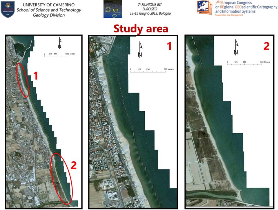
14 Monitoring of San Benedetto del Tronto beach (AP)

15 Study area
16 Issues related to erosion December 2008 January 2012

17 Monitoring of S. Benedetto del Tronto coastline: Geographical information system for data management ESRI ArcGIS 9.3 upgradability integration multidisciplinary creation of thematic maps previous data vectorial and raster data Multitemporality & Storage

 Sedimentological analysis FINE")
18 Monitoring of S.Benedetto del Tronto coastline 1) Sedimentological analysis FINE SAND 2) GPS survey of the coastline 3) Bathymetric survey
 GPS survey of the")

19 GPS survey of the coastline

20 GPS survey of the coastline

21 Bathymetric survey
22 Possible causes of erosion
23 Possible causes of erosion
24 Conclusions A complete and homogeneous database has been realized. It allows to obtain a multidisciplinary, multitemporal and multiscale analysis. The historical evolution analysis of the coastline is the first step to set up a beach monitoring, aimed to individuate the possible erosion processes and planning future events.
25 THANK YOU FOR ATTENTION Working group: Prof. Carlo Bisci Prof. Gino Cantalamessa Ing. Giorgio Di Pancrazio
ArcGIS Data Models Practical Templates for Implementing GIS Projects
 ArcGIS Data Models Practical Templates for Implementing GIS Projects GIS Database Design According to C.J. Date (1995), database design deals with the logical representation of data in a database. The
Progress of SIGC -Coastal Geographical Information System
 Progress of SIGC -Coastal Geographical Information System Filippo D Ascola, Angela Barbano ISPRA -Istituto Superiore per la Protezione e la Ricerca Ambientale Dip.to Tutela Acque Interne e Marine - Servizio
Applications of GIS and Web delivery of coastal monitoring data in shoreline management
 Applications of GIS and Web delivery of coastal monitoring data in shoreline management Bradbury AP, Cooper T and Mason TE Channel Coastal Observatory, UK Abstract Effective planning and implementation
Martin County Coastal GIS Program St Lucie Inlet Planning Tool
 Martin County Coastal GIS Program St Lucie Inlet Planning Tool Alexandra Carvalho, Ph.D., GISP Kathy Fitzpatrick, P.E. Jessica Garland Martin County, Florida Presentation Overview County Coastal Programs
REGIONAL SEDIMENT MANAGEMENT: A GIS APPROACH TO SPATIAL DATA ANALYSIS. Lynn Copeland Hardegree, Jennifer M. Wozencraft 1, Rose Dopsovic 2 INTRODUCTION
 REGIONAL SEDIMENT MANAGEMENT: A GIS APPROACH TO SPATIAL DATA ANALYSIS Lynn Copeland Hardegree, Jennifer M. Wozencraft 1, Rose Dopsovic 2 ABSTRACT: Regional sediment management (RSM) requires the capability
Managing Bathymetry in the Cloud with GIS
 Esri Maritime Professional Services GEBCO Science Day Tuesday, October 4, 2011 Managing Bathymetry in the Cloud with GIS Timothy Kearns & Beata Van Esch Overview The challenges of bathymetry in GIS - What
GEOGRAPHIC INFORMATION SYSTEMS CERTIFICATION
 GEOGRAPHIC INFORMATION SYSTEMS CERTIFICATION GIS Syllabus - Version 1.2 January 2007 Copyright AICA-CEPIS 2009 1 Version 1 January 2007 GIS Certification Programme 1. Target The GIS certification is aimed
Using LIDAR to monitor beach changes: Goochs Beach, Kennebunk, Maine
 Geologic Site of the Month February, 2010 Using LIDAR to monitor beach changes: Goochs Beach, Kennebunk, Maine 43 o 20 51.31 N, 70 o 28 54.18 W Text by Peter Slovinsky, Department of Agriculture, Conservation
Remote Sensing, GPS and GIS Technique to Produce a Bathymetric Map
 Remote Sensing, GPS and GIS Technique to Produce a Bathymetric Map Mark Schnur EES 5053 Remote Sensing Fall 2007 University of Texas at San Antonio, Department of Earth and Environmental Science, San Antonio,
An adaptive approach to monitor the Shoreline changes in ICZM framework: A case study of Chennai coast
 Indian Journal of Geo-Marine Sciences Vol. 43 (7), July 2014, pp. 1266-1271 An adaptive approach to monitor the Shoreline changes in ICZM framework: A case study of Chennai coast R. S. Kankara *, S. Chenthamil
An Initial Assessment of the Impacts of Sea Level Rise to the California Coast
 An Initial Assessment of the Impacts of Sea Level Rise to the California Coast Photo by D. Revell 2/23/08 California Coastal Records Project Dr. David Revell and Matt Heberger, P.E. Dr. Peter Gleick, Bob
Geology 12 Syllabus House, Fall 2010
 INSTRUCTOR INFORMATION Dr. Martha House; Office E210B; Office hours posted at office; Voice (626) 585-7026; Email mahouse@pasadena.edu REQUIRED MATERIALS: Textbook Essentials of Oceanography (Thurman and
Predicting Coastal Hazards: A Southern California Demonstration
 Predicting Coastal Hazards: A Southern California Demonstration Patrick Barnard United States Geological Survey Coastal and Marine Geology Team Santa Cruz, CA Southern California Multi-hazards Demonstration
Open-File Report 2006-1219. Cheryl J. Hapke, David Reid, Bruce M. Richmond, Peter Ruggiero and Jeff List
 National Assessment of Shoreline Change Part 3: Historical Shoreline Change and Associated Coastal Land Loss Along Sandy Shorelines of the California Coast Cheryl J. Hapke, David Reid, Bruce M. Richmond,
Shoreline Change Prediction Model for Coastal Zone Management in Thailand
 Journal of Shipping and Ocean Engineering 2 (2012) 238-243 D DAVID PUBLISHING Shoreline Change Prediction Model for Coastal Zone Management in Thailand Siriluk Prukpitikul, Varatip Buakaew, Watchara Keshdet,
SECTION 10.0 MANAGEMENT UNIT 5: HORNSEA
 10.1 Summary Information 10.1.1 Location SECTION 10.0 MANAGEMENT UNIT 5: HORNSEA The limits of Management Unit 5, a 2.9km stretch of shoreline fronting the town of Hornsea on the Holderness coast, are
Coastal Erosion Hazard Monitoring on the South Shore of Long Island, New York Joseph J. Tanski 1 and Barry Pendergrass 2
 Abstract Coastal Erosion Hazard Monitoring on the South Shore of Long Island, New York Joseph J. Tanski 1 and Barry Pendergrass 2 The Atlantic Coast of New York Erosion Monitoring Program (ACNYMP), initiated
SHOALS Toolbox: Software to Support Visualization and Analysis of Large, High-Density Data Sets
 SHOALS Toolbox: Software to Support Visualization and Analysis of Large, High-Density Data Sets by Jennifer M. Wozencraft, W. Jeff Lillycrop, and Nicholas C. Kraus PURPOSE: The Coastal and Hydraulics Engineering
A GIS helps you answer questions and solve problems by looking at your data in a way that is quickly understood and easily shared.
 A Geographic Information System (GIS) integrates hardware, software, and data for capturing, managing, analyzing, and displaying all forms of geographically referenced information. GIS allows us to view,
Introduction to GIS (Basics, Data, Analysis) & Case Studies. 13 th May 2004. Content. What is GIS?
 & Case Studies. 13 th May 2004. Content. What is GIS?") Introduction to GIS (Basics, Data, Analysis) & Case Studies 13 th May 2004 Content Introduction to GIS Data concepts Data input Analysis Applications selected examples What is GIS? Geographic Information
Introduction to GIS (Basics, Data, Analysis) & Case Studies 13 th May 2004 Content Introduction to GIS Data concepts Data input Analysis Applications selected examples What is GIS? Geographic Information
Why Demographic Data are not Up to the Challenge of Measuring Climate Risks, and What to do about it. CIESIN Columbia University
 UN Conference on Climate Change and Official Statistics Oslo, Norway, 14-16 April 2008 Why Demographic Data are not Up to the Challenge of Measuring Climate Risks, and What to do about it CIESIN Columbia
Effects of Florida Under a 10 Meter Sea Level Rise
 Effects of Florida Under a 10 Meter Sea Level Rise Chance B. Murray Dec. 7 2009 I. Goal Assess the effects a 10 meter sea level rise would have on Florida. Mission: Determine the length of Florida s coastline
The Integration of Hydrographic and Oceanographic Data in a Marine Geographic Information System U.S. Hydro 2015
 The Integration of Hydrographic and Oceanographic Data in a Marine Geographic Information System U.S. Hydro 2015 Karen Hart CARIS USA Oceanography and Hydrography Defined Oceanography: The branch of Earth
Digital Orthophoto Production In the Desktop Environment 1
 Digital Orthophoto Production In the Desktop Environment 1 By Dr. Roy A. Welch and Thomas R. Jordan Digital orthophotos are proving suitable for a variety of mapping, GIS and environmental monitoring tasks.
DISASTER DISASTER MANAGEMENT CRISIS INFORMATICS GIS IN DIFFEERENT STAGES OF DISASTER MANAGEMENT
 APPLICATION OF GIS AND REMOTE SENSING IN DISASTER PRONE AREAS: A CASE STUDY IN COASTAL KERALA DISASTER Disaster is an unpleasant event than occurs with little or no warning which results in economic disruption,
About As. In a team with the best. ESRI Bulgaria is the exclusive distributor of Esri Inc. for Bulgaria. Esri Inc.
 About As ESRI Bulgaria is an IT company, leader in the field of Geographic Information Systems (GIS) on the Bulgarian market. Offering the most advanced high-tech products, solutions and services, ESRI
Final Project Report
 CURTIN UNIVERSITY OF TECHNOLOGY Department of Applied Geology Western Australia School of Mines Applied Sedimentology, Coastal and Marine Geoscience Group GERALDTON EMBAYMENTS COASTAL SEDIMENT BUDGET STUDY
Large-scale multi-agency strategic beach monitoring of the South-East Coast of England provision of data and analytical tools.
 Large-scale multi-agency strategic beach monitoring of the South-East Coast of England provision of data and analytical tools. Prof. Andrew Bradbury*; Dr Travis Mason*; and Peter Barter + *Channel Coastal
Analyzing Radon Risk Using Geographic Information System (GIS) Software. Ü Radon and GIS
 Software. Ü Radon and GIS") Analyzing Radon Risk Using Geographic Information System (GIS) Software Ü Radon and GIS Introduction Radon testing data is submitted by licensees to the Illinois Emergency Management Agency One way they
Analyzing Radon Risk Using Geographic Information System (GIS) Software Ü Radon and GIS Introduction Radon testing data is submitted by licensees to the Illinois Emergency Management Agency One way they
Geography. Geography B. Curriculum Planner GCSE 2012. Version 1 October 2012
 Geography GCSE 2012 Geography B Curriculum Planner Version 1 October 2012 www.ocr.org.uk/gcse2012 INTRODUCTION This plan is not deemed to be prescriptive, it is one suggested route through the specification.
Introduction to GIS. http://libguides.mit.edu/gis
 Introduction to GIS http://libguides.mit.edu/gis 1 Overview What is GIS? Types of Data and Projections What can I do with GIS? Data Sources and Formats Software Data Management Tips 2 What is GIS? 3 Characteristics
G3-Giornate Giovani GNRAC Quartiere Fieristico di Ferrara, 21 Settembre 2012
 3 SALONE SULLA TUTELA DELLA COSTA COAST PROTECTION EXHIBITION 2 ND EDITION G3-Giornate Giovani GNRAC Quartiere Fieristico di Coastal vulnerability assessment to climate change. CVI Index application to
METHODOLOGY FOR LANDSLIDE SUSCEPTIBILITY AND HAZARD MAPPING USING GIS AND SDI
 The 8th International Conference on Geo-information for Disaster Management Intelligent Systems for Crisis Management METHODOLOGY FOR LANDSLIDE SUSCEPTIBILITY AND HAZARD MAPPING USING GIS AND SDI T. Fernández
MAIN_SNP_TOPO.dgm_2m
 Seite 1 von 7 MAIN_SNP_TOPO.dgm_2m SDE Raster Dataset Tags dgm_2m, dgm_gr_snp, dgm1177bis1258, dtm4, lomb_dtm_20, dem2_5_apb, dhm10, dem20_apb, dsm2_voralberg, dsm10_tirol Summary There is no summary for
December 19, 2014. Donna Macalle-Holly Lake Hopatcong Foundation 37 Nolan s Point Park Road Lake Hopatcong, NJ 07849. Dear Ms.
 Biology Department Drew University 36 Madison Avenue Madison, New Jersey 07940 Lisa Jordan Assistant Professor, Environmental Studies e. ljordan@drew.edu p. 973.408.3740 drew.edu/ess December 19, 2014
The Use of Geographic Information Systems in Risk Assessment
 The Use of Geographic Information Systems in Risk Assessment With Specific Focus on the RiVAMP Methodology Presented by Nadine Brown August 27, 2012 Climate Studies Group Mona Climate Change Workshop Presentation
Ocean Engineering, Surveying and Mapping Services
 Ocean Engineering, Surveying and Mapping Services FUGRO PELAGOS, INC. Fugro collects and interprets data related to the earth s surface and the soils and rocks beneath. It provides advice based on the
Sextant. Spatial Data Infrastructure for Marine Environment. C. Satra Le Bris, E. Quimbert, M. Treguer
 Sextant On-Line information system for marine geographical information E. Quimbert, M. Bellouis, F. Lecuy, M. Treguer Centre de Bretagne BP 70, Plouzané 29280 France E-mail: sextant@ifremer.fr Sextant
Illinois Coastal Management Program 2011
 4 Coastal Erosion Assessment and Planning The Lake Michigan coast is a dynamic setting influenced by waves, ice, and changing lake levels. The potential for coastal erosion exists along nearly the entire
1. Executive Summary
 1. Executive Summary 1.1. The character of the coast of Wales is defined by continuous change, erosion and accretion, a dynamism that will increase in the future with climate change driven sea level rise
What is GIS? Geographic Information Systems. Introduction to ArcGIS. GIS Maps Contain Layers. What Can You Do With GIS? Layers Can Contain Features
 What is GIS? Geographic Information Systems Introduction to ArcGIS A database system in which the organizing principle is explicitly SPATIAL For CPSC 178 Visualization: Data, Pixels, and Ideas. What Can
MAREMED kick off meeting
 MAREMED kick off meeting MEDITERRANEAN BASIN (Italy) Spatial Planning Department Orietta Gattulli economic management Marino Fiorito computer service center 22 June 2010 REGION PROVENCE-ALPES-CÔTE D AZUR
AQUITAINE COAST (FRANCE)
") AQUITAINE COAST (FRANCE) Contact: Jean Christophe LE BRETON Anne GUCHAN Conseil Regional d Aquitaine 14 Rue François de Sourdis 33077 Bordeaux (CEDEX) 10 Tel: +34 055 757 83 06 Fax: +34 055 656 38 06 e-mail:
AQUITAINE COAST (FRANCE) Contact: Jean Christophe LE BRETON Anne GUCHAN Conseil Regional d Aquitaine 14 Rue François de Sourdis 33077 Bordeaux (CEDEX) 10 Tel: +34 055 757 83 06 Fax: +34 055 656 38 06 e-mail:
Introduction to GIS. Dr F. Escobar, Assoc Prof G. Hunter, Assoc Prof I. Bishop, Dr A. Zerger Department of Geomatics, The University of Melbourne
 Introduction to GIS 1 Introduction to GIS http://www.sli.unimelb.edu.au/gisweb/ Dr F. Escobar, Assoc Prof G. Hunter, Assoc Prof I. Bishop, Dr A. Zerger Department of Geomatics, The University of Melbourne
Toma Danila Dragos. National Institute for Earth Physics Romania
 Toma Danila Dragos National Institute for Earth Physics Romania Before: evaluate the hazard and risk, be prepared for worst case scenario Natural or antropic disaster After: quickly evaluate the situation
The Coast of Crystal Cove Orange County, California
 The Coast of Crystal Cove Orange County, California by Hany Elwany, Ph.D. Scripps Institution of Oceanography Megan Hamilton, M.Sc. Coastal Environments Robert Robinson Dept. of Parks & Recreation Headwaters
GIT Geology and Information Technology 8a Riunione del Gruppo di Geologia informatica Sezione della Società Geologica Italiana
 Mauro De Donatis Open Source Mobile GIS tools for teaching and learning field mapping techniques: an educational resource or just a breaking of conventions (and the bane of your existence)? Università
Data access and management
 B Data access and management CONTENTS B.1 Introduction... B-1 B.2 Data requirements and availability... B-1 B.3 Data access... B-2 B.4 Overall procedures... B-2 B.5 Data tools and management... B-4 Appendix
The Geosites of the province of Venice
 The Geosites of the province of Venice A. Vitturi, V. Bassan, A. Bondesan, C. Levorato Department of Soil Defence Geological Survey Italian Society of Environmental Geology 1 The data base The data base,
BEACH NOURISHMENT COMBINED WITH SIC VERTICAL DRAIN IN MALAYSIA.
 BEACH NOURISHMENT COMBINED WITH SIC VERTICAL DRAIN IN MALAYSIA. Claus Brøgger 1 and Poul Jakobsen 2 The present paper presents measurements and results from a three year full scale Pilot Project with the
COASTAL DAMAGE INSPECTION SOUTHWEST VITI LEVU, FIJI AFTER CYCLONE SINA
 COASTAL DAMAGE INSPECTION SOUTHWEST VITI LEVU, FIJI AFTER CYCLONE SINA Brendan J. Holden SOPAC Technical Secretariat July 1992 SOPAC Technical Report 148 Prepared for: South Pacific Applied Geoscience
Understanding Raster Data
 Introduction The following document is intended to provide a basic understanding of raster data. Raster data layers (commonly referred to as grids) are the essential data layers used in all tools developed
CONTINUING EROSION IN SOUTHEASTERN COASTAL MISSISSIPPI - POINT AUX CHENES BAY, WEST GRAND BAY, MIDDLE BAY, GRANDE BATTURE ISLANDS: 1995-1997
 Summary of a Poster Presented at the: Sixty-Second Annual Meeting of the Mississippi Academy of Sciences in Biloxi, Mississippi February 26-27, 1998 ===============================================================
2 Context to erosion projections used in the ESC
 Halcrow Group Limited Lyndon House, 62 Hagley Road, Edgbaston, Birmingham B16 8PE tel 0121 456 2345 fax 0121 456 1569 halcrow.com Technical note Project LLWR ESC Technical Queries Date 11 December 2012
Introduction to Geographic Information Systems. A brief overview of what you need to know before learning How to use any GIS software packages
 Introduction to Geographic Information Systems A brief overview of what you need to know before learning How to use any GIS software packages 1 What is GIS? More than map-making software GIS is a system
Creation of Soil Liquefaction Susceptibility Maps for San Luis Obispo & Marin Counties using Geographic Information Systems.
 Creation of Soil Liquefaction Susceptibility Maps for San Luis Obispo & Marin Counties using Geographic Information Systems. Amelia M. Lowman December 2009 Dr. Lynn E. Moody Adviser Earth and Soil Sciences
Regione Lazio Italy Direzione Regionale Ambiente e Cooperazione tra i Popoli
 Overview What is BEACHEMED-e Operation? The Sub-project OBSEMEDI The new European Projects EURIOMCODE 2 Main Features of Beachmed-e Operation Regional Framework Operation of INTERREGIIIC South Zone EU
Institute of Natural Resources Departament of General Geology and Land use planning Work with a MAPS
 Institute of Natural Resources Departament of General Geology and Land use planning Work with a MAPS Lecturers: Berchuk V.Y. Gutareva N.Y. Contents: 1. Qgis; 2. General information; 3. Qgis desktop; 4.
SHOALS Toolbox: Software to Support Visualization and Analysis of Large, High-Density Data Sets
 SHOALS Toolbox: Software to Support Visualization and Analysis of Large, High-Density Data Sets by Jennifer M. Wozencraft, W. Jeff Lillycrop, and Nicholas C. Kraus PURPOSE: The Coastal and Hydraulics Engineering
CIESIN Columbia University
 Conference on Climate Change and Official Statistics Oslo, Norway, 14-16 April 2008 The Role of Spatial Data Infrastructure in Integrating Climate Change Information with a Focus on Monitoring Observed
SITE INVESTIGATIONS OF THE BEACH EROSION PROBLEM AT MAHO BEACH, ST. MAARTEN
 SITE INVESTIGATIONS OF THE BEACH EROSION PROBLEM AT MAHO BEACH, ST. MAARTEN Performed February 2003 Performed by: Dr. Lee E. Harris, Ph.D., P.E. Associate Professor of Ocean Engineering & Oceanography
Spatially Enabling SharePoint
 www.environment.gov.au/ssd Spatially Enabling SharePoint Renee Bartolo Program Leader, Spatial Sciences and Data Integration Supervising Scientist - working to protect the environment from the impacts
Applying GIS in seismic hazard assessment and data integration for disaster management
 Applying GIS in seismic hazard assessment and data integration for disaster management Rumiana Vatseva, Dimcho Solakov, Emilia Tcherkezova, Stela Simeonova, Petya Trifonova National Institute of Geophysics,
WHAT IS GIS - AN INRODUCTION
 WHAT IS GIS - AN INRODUCTION GIS DEFINITION GIS is an acronym for: Geographic Information Systems Geographic This term is used because GIS tend to deal primarily with geographic or spatial features. Information
INSTITUTE OF HUMAN RESOURSE ADVANCEMENT (IHRA) UNIVERSITY OF COLOMBO. M. Sc. in Geoinformatics 2014/2015
 UNIVERSITY OF COLOMBO. M. Sc. in Geoinformatics 2014/2015") INSTITUTE OF HUMAN RESOURSE ADVANCEMENT (IHRA) UNIVERSITY OF COLOMBO Introduction M. Sc. in Geoinformatics 2014/2015 Course Conducted by the -IHRA, University of Colombo The Master of Science in Geoinformatics
INSTITUTE OF HUMAN RESOURSE ADVANCEMENT (IHRA) UNIVERSITY OF COLOMBO Introduction M. Sc. in Geoinformatics 2014/2015 Course Conducted by the -IHRA, University of Colombo The Master of Science in Geoinformatics
Mount Laurel Township MUA Hydrant Maintenance Program. Using ArcPad to Track Hydrant Flow Testing and Flushing procedures
 Mount Laurel Township MUA Hydrant Maintenance Program Using ArcPad to Track Hydrant Flow Testing and Flushing procedures What is the Mount Laurel MUA? The Mount Laurel Township, Municipal Utilities Authority
For St. Kitts, this would be an investment of approximately US$100 million
 35 Policies Leading to Vulnerability Example: Seaside (Beachfront) Tourism Policy Of 77,438 accommodation rooms built in the Commonwealth Caribbean it is estimated that well over 65 per cent are in coastal
What is GIS. What is GIS? University of Tsukuba. What do you image of GIS? Copyright(C) ESRI Japan Corporation. All rights reserved.
 ESRI Japan Corporation. All rights reserved.") What is GIS University of Tsukuba Graduate School of Life and Environmental Science April 21 st, 2011 What is GIS? What do you image of GIS? Gas Insulated Switch Groupe Interventional Speciale Geographic
What is GIS University of Tsukuba Graduate School of Life and Environmental Science April 21 st, 2011 What is GIS? What do you image of GIS? Gas Insulated Switch Groupe Interventional Speciale Geographic
A METHODOLOGY FOR GIS INTERFACING OF MARINE DATA
 A METHODOLOGY FOR GIS INTERFACING OF MARINE DATA Proceedings of GIS PLANET 98: International Conference and Exhibition on Geographic Information, Lisbon, Portugal, 7-11 September 1998 Vasilis Valavanis,
VGIS HANDBOOK PART 2 - STANDARDS SECTION D METADATA STANDARD
 VGIS HANDBOOK PART 2 - STANDARDS SECTION D Vermont Geographic Information System Standard History November 15, 1989 version 1a - Section A: Digitizing Data adopted by Policy Advisory Board January, 1991
GIS Initiative: Developing an atmospheric data model for GIS. Olga Wilhelmi (ESIG), Jennifer Boehnert (RAP/ESIG) and Terri Betancourt (RAP)
, Jennifer Boehnert (RAP/ESIG) and Terri Betancourt (RAP)") GIS Initiative: Developing an atmospheric data model for GIS Olga Wilhelmi (ESIG), Jennifer Boehnert (RAP/ESIG) and Terri Betancourt (RAP) Unidata seminar August 30, 2004 Presentation Outline Overview
GIS Initiative: Developing an atmospheric data model for GIS Olga Wilhelmi (ESIG), Jennifer Boehnert (RAP/ESIG) and Terri Betancourt (RAP) Unidata seminar August 30, 2004 Presentation Outline Overview
DRAFT. Shoreline adaptation alternatives development to determine flood reduction potential and project costs
 Scope of Services Phase 1A: Flood Damage Assessment Economic Analysis of the Delaware Bay Shoreline Adaptation Alternatives Task Order No. 1A Structures/Affected Property Inventory January 13, 2011 Johnson,
Utilizing satellite-based information for disaster risk assessment- why and how?
 Utilizing satellite-based information for disaster risk assessment- why and how? Peeranan Towashiraporn ADPC Session 1, UN International Conference on Space-based Technologies for Disaster Management September
Christian J. Stewart, Christian J. Stewart Consulting James G. Duyndam, Christian J. Stewart Consulting Mark N. Law, Christian J. Stewart Consulting
 COASTAL ZONE GIS DATABASE DEVELOPMENT, VISUALIZATION AND DISTRIBUTION IN THE GREAT LAKES - THE LAKE MICHIGAN POTENTIAL DAMAGES STUDY AND THE LOWER GREAT LAKES EROSION STUDY Christian J. Stewart, Christian
Coastal Erosion Risk Mitigation Strategies applied in a Small Island Developing State: The Barbados Model
 Coastal Erosion Risk Mitigation Strategies applied in a Small Island Developing State: The Barbados Model BY Dr. Leo Brewster, Director Coastal Zone Management Unit, Barbados Presented At UNFCCC Expert
VENETOREGION ROAD NETWORK ROAD MAPPING LASER SCANNING FACILITY MANAGEMENT
 VENETOREGION ROAD NETWORK ROAD MAPPING LASER SCANNING FACILITY MANAGEMENT ing. Augusto Burchi burchi@sitecoinf.it Siteco profile Italian software house specialized in GIS and RDBMS dedicated to Road networks
Hazards of the Jamaican Coastline ERODING BEACHES: A RESPONSE TO RISING SEA LEVEL?
 Hazards of the Jamaican Coastline ERODING BEACHES: A RESPONSE TO RISING SEA LEVEL? This is the fourth in a series of articles on Hazards of the Jamaican Coastline contributed by the Marine Geology Unit,
The Marine Protected Area Inventory
 The Marine Protected Area Inventory New pictures Jordan Gass, Hugo Selbie and Charlie Wahle ESRI Ocean Forum November 6, 2013 Outline What is the MPA Inventory? Purpose Data How it s used Future directions
A Bayesian Network to Predict Vulnerability to Sea-Level Rise: Data Report
 7 A Bayesian Network to Predict Vulnerability to Sea-Level Rise: Data Report Data Series 2011 601 U.S. Department of the Interior U.S. Geological Survey Cover. Cover caption goes here A Bayesian Network
L Aquila, 22 Ottobre The 2008 SDI: a knowledge based system Venice, 21-23 March 2011. Cartogra. SIT e la C
 1 afia Palazzo Franchetti Venice Italy International Conference Data Dt Flow From Space to Earth Applications and interoperability The SDI: a knowledge based system Maurizio De Gennaro, Silvano De Zorzi,
NASA DEVELOP s 3-D Visualizations and Remote Sensing Applications. NASA DEVELOP, a student-led project headquartered at NASA Langley, allows
 Abstract NASA DEVELOP, a student-led project headquartered at NASA Langley, allows students to demonstrate remote-sensing techniques that are used to create visualizations, which aid communities in solving
GIS: Geographic Information Systems A short introduction
 GIS: Geographic Information Systems A short introduction Outline The Center for Digital Scholarship What is GIS? Data types GIS software and analysis Campus GIS resources Center for Digital Scholarship
EARTHQUAKE DISASTER GIS AND SPATIAL-TEMPORAL PATTERN OF EARTHQUAKE DISASTERS IN CHINA1
 EARTHQUAKE DISASTER GIS AND SPATIAL-TEMPORAL PATTERN OF EARTHQUAKE DISASTERS IN CHINA1 Mao Feng 1 and Ma Jin feng 2 and Zhou Wen sheng 3 1 Professor,School of Architecture,Tsinghua University, BeiJing.
Minnesota Department of Natural Resources \mn_dnr \mn_dnr\spatial \mn_dnr\tabular \mn_dnr\metadata
 INDEX OF GIS SPATIAL DATA, TABULAR DATA, AND METADATA ASSOCIATED WITH REPORT 380, AGGREGATE RESOURCE POTENTIAL PARTS OF NORTHERN ST. LOUIS AND LAKE COUNTIES, MN. Project of the Minnesota Department of
Section E2 Coastal Engineering: Reconstruction Management and Mitigation
 271 Section E2 Coastal Engineering: Reconstruction Management and Mitigation 272 Objectives To familiarize the assessor with the process that should be followed in organizing any reconstruction efforts.
Reading Questions. Lo and Yeung, 2007: 2 19. Schuurman, 2004: Chapter 1. 1. What distinguishes data from information? How are data represented?
 Reading Questions Week two Lo and Yeung, 2007: 2 19. Schuurman, 2004: Chapter 1. 1. What distinguishes data from information? How are data represented? 2. What sort of problems are GIS designed to solve?
KEY WORDS: Geoinformatics, Geoinformation technique, Remote Sensing, Information technique, Curriculum, Surveyor.
 CURRICULUM OF GEOINFORMATICS INTEGRATION OF REMOTE SENSING AND GEOGRAPHICAL INFORMATION TECHNOLOGY Kirsi VIRRANTAUS*, Henrik HAGGRÉN** Helsinki University of Technology, Finland Department of Surveying
Digital Cadastral Maps in Land Information Systems
 LIBER QUARTERLY, ISSN 1435-5205 LIBER 1999. All rights reserved K.G. Saur, Munich. Printed in Germany Digital Cadastral Maps in Land Information Systems by PIOTR CICHOCINSKI ABSTRACT This paper presents
Create a folder on your network drive called DEM. This is where data for the first part of this lesson will be stored.
 In this lesson you will create a Digital Elevation Model (DEM). A DEM is a gridded array of elevations. In its raw form it is an ASCII, or text, file. First, you will interpolate elevations on a topographic
Quality Assurance Reviews of Hydraulic Models Developed for the Central Valley Floodplain Evaluation and Delineation Program
 Quality Assurance Reviews of Hydraulic Models Developed for the Central Valley Floodplain Evaluation and Delineation Program Techniques Applied and Lessons Learned Seth Ahrens, P.E., CFM Selena Forman,
Location Analytics across Curriculum: Lessons from a Business School
 Location Analytics across Curriculum: Lessons from a Business School Avijit Sarkar, James Pick, Steven Moore University of Redlands Esri Education GIS Conference San Diego CA July 2015 Location Analytics
ITALIAN SPATIAL DATA INFRASTRUCTURE
 Il Sistema Informativo Catastale: una risorsa per le politiche di governo del territorio Roma, 10-11 dicembre 2008 ITALIAN SPATIAL DATA INFRASTRUCTURE Elettra Cappadozzi National Centre for ICT in the
Metadata for Big River Watershed Geologic and Geomorphic Data
 Metadata for Big River Watershed Geologic and Geomorphic Data Metadata are descriptions and information regarding compiled data. This appendix contains the metadata that describes the compiled data used
Technology Trends In Geoinformation
 Technology Trends In Geoinformation Dato Prof. Sr Dr. Abdul Kadir Bin Taib Department of Survey and Mapping Malaysia (JUPEM) Email: drkadir@jupem.gov.my www.jupem.gov.my NGIS 2008 3 rd. National GIS Conference
Island County, Washington REQUEST FOR PROPOSALS (RFP) GIS Data Inventory Update for Shoreline Compliance
 GIS Data Inventory Update for Shoreline Compliance") Island County, Washington REQUEST FOR PROPOSALS (RFP) GIS Data Inventory Update for Shoreline Compliance Send Proposal Packages to: Tess Cooper, Critical Area Planner Island County Planning and Community
Island County, Washington REQUEST FOR PROPOSALS (RFP) GIS Data Inventory Update for Shoreline Compliance Send Proposal Packages to: Tess Cooper, Critical Area Planner Island County Planning and Community
Geographic Information Systems (GIS) @ GIS at UCSD. Here to help you explore our world
 @ GIS at UCSD. Here to help you explore our world") Geographic Information Systems (GIS) @ GIS at UCSD Here to help you explore our world GIS at UCSD what it is and what it means to you Tracey Hughes UCSD GIS Coordinator 2006 Image from Google Earth An
Geographic Information Systems (GIS) @ GIS at UCSD Here to help you explore our world GIS at UCSD what it is and what it means to you Tracey Hughes UCSD GIS Coordinator 2006 Image from Google Earth An
GIT Geology and Information Technology
 Luca Fallati Università degli Studi di Milano-Bicocca: MaRHE Marine Research and High Educational Centre Land Use Changes (LUC) in developing countries are: - faster and widespread; - often not surveyed
MAPPING THE ST. FRANCIS DAM OUTBURST FLOOD WITH GEOGRAPHIC INFORMATION SYSTEMS
 MAPPING THE ST. FRANCIS DAM OUTBURST FLOOD WITH GEOGRAPHIC INFORMATION SYSTEMS J. David Rogers Kevin James Department of Geological Engineering University of Missouri-Rolla St. Francis Dam was a 200-ft
A Case Study Documenting the Dubai Coastal Zone Monitoring Programme An International Example.
 A Case Study Documenting the Dubai Coastal Zone Monitoring Programme An International Example. prepared in the framework of the MESSINA project December 2005 Project part-financed by the European Union
Using Spatial Statistics In GIS
 Using Spatial Statistics In GIS K. Krivoruchko a and C.A. Gotway b a Environmental Systems Research Institute, 380 New York Street, Redlands, CA 92373-8100, USA b Centers for Disease Control and Prevention;